Embed Size (px)
Citation preview
AC Transit East Bay Bus Rapid Transit Projectin Alameda County
Final Environmental Impact Statement/Environmental Impact ReportPursuant to
National Environmental Policy Act of 1969, §102 (42 U.S.C. §4332); Federal Transit Laws (49 U.S.C. §5301(e), §5323(b) and §5324(b)); National Historic Preservation Act of 1966, §106 (16 U.S.C. §470f); 40 CFR Parts 1500-1508; 23 CFR Part 771; Executive Order 12898
(Environmental Justice); and California Environmental Quality Act, PRC 21000 et seq.; and the State of California CEQA Guidelines, California Administrative Code, 15000 et seq.
by the U.S. Department of Transportation/Federal Transit Administrationand the Alameda Contra Costa Transit District
Historic Property Survey Report (HPSR)First Addendum
November 2010
Separate File-ASR
Separate File-HPIER
Separate File
Separate File

Lake Merritt
ColiseumComplex
University of CaliforniaBerkeley
BERKELEYBERKELEY
OAKLANDOAKLAND
SANSANLEANDROLEANDRO
HIGHST.
MacARTHUR
MARINA BLVD.
HALCYON DR.
BANCROFT AVE.
BA
NC
RO
FT AVE.
35TH AVE.FRUITV
ALEAVE.
LINCOLN AVE.
FOOTHILL
73RDAVE.
SEMINARYAVE.
98TH AVE.
DAVIS ST.
14TH AVE.
PARK BLVD.
OAKLAND
AVE.
ALCATRAZAVE.
UNIVERSITY AVE.
GILMAN ST.
ST.
COLL
EGE
AVE.
MARKETST.
7THBROADWAY PIEDMONT
FOO
THILL BLVD.
MANDELA
PKWY.
HO
LLIS
ST.
ASHBY
DWIGHT WY.
SAN
PA
BLO
AVE
.
STANFORD AVE.
E. 14
TH
ST.
23RD
AVE.
SIXT
H
S
T.
M. L
. KIN
G J
R. W
Y.
TELE
GRA
PH
AVE
.
U.P.R.R..
U.P.R.R..U.P.R.R.
U.P
.R.R
.
14THST.
AVE.
ST.
HESP
ERIA
NBL
VD.
MacAR
THU
RB
LVD.
FRWY.
BROADWAY TER.
MORAGA
HEGE
NBER
GER
RD.
AVE.
SAC
RAM
ENTO
ST.
ADELIN
EW. GRAND
AV
E.
AVE.
GRAND AVE
.
FRWY.
WAR
REN
INTERNATIONALBLVD.
BLVD.
AVE.
HORE
ES
LAK
580
580
580
580
238
185
185
13
24
13
123
123
13
Inner Harbor
San LeandroBay
S a n F r a n c i s c o
B a y
ALAMEDAALAMEDA
HAYWARDHAYWARD
SHAT
TUC
K
11 THST.
12 THST.
JACKSON ST.
OX
FOR
D S
T.
BANCROFT WAY
OaklandInternational
Airport
40 THMacARTHURBLVD.
AV
E.
DURANT AVE.
20 THST.
580
Redwood
Regional
Park
Anthony Chabot
Robert SibleyVolcanic Reg.
Preserve
24
Knowland Park
SNAKE
CANYONRD.
RD.
SHEP
HERD
Park
GOLF LINKS
RD.
SKYLIN
E
BLVD.
Regional
/E. 14
THS
T.
S a n F r a n c i s c o
B a y
Lake Merritt
ColiseumComplex
University of CaliforniaBerkeley
BERKELEYBERKELEY
OAKLANDOAKLAND
SANSANLEANDROLEANDRO
HIGHST.
MacARTHUR
MARINA BLVD.
HALCYON DR.
BANCROFT AVE.
BA
NC
RO
FT AVE.
35TH AVE.FRUITV
ALEAVE.
LINCOLN AVE.
FOOTHILL
73RDAVE.
SEMINARYAVE.
98TH AVE.
DAVIS ST.
14TH AVE.
PARK BLVD.
OAKLAND
AVE.
ALCATRAZAVE.
UNIVERSITY AVE.
GILMAN ST.
ST.
COLL
EGE
AVE.
MARKETST.
7THBROADWAY PIEDMONT
FOO
THILL BLVD.
MANDELA
PKWY.
HO
LLIS
ST.
ASHBY
DWIGHT WY.
SAN
PA
BLO
AVE
.
STANFORD AVE.
E. 14
TH
ST .
23RD
AVE.
SIXT
H
S
T.
M. L
. KIN
G J
R. W
Y.
TELE
GRA
PH
AVE
.
U.P.R.R..
U.P.R.R..U.P.R.R.
U.P
.R.R
.
14THST.
AVE.
ST.
HESP
ERIA
NBL
VD.
MacAR
THU
RB
LVD.
FRWY.
BROADWAY TER.
MORAGA
HEGE
NBER
GER
RD.
AVE.
SAC
RAM
ENTO
ST.
ADELIN
EW. GRAND
AV
E.
AVE.
GRAND AVE
.
FRWY.
WAR
REN
INTERNATIONALBLVD.
BLVD.
AVE.
HORE
ES
LAK
580580
580580
580580
580580
238238
185185
185185
1313
2424
1313
123123
123123
1313
Inner Harbor
San LeandroBay
S a n F r a n c i s c o
B a y
ALAMEDAALAMEDA
HAYWARDHAYWARD
SHAT
TUC
K
SHAT
TUC
K
11 THST.
12 THST.
JACKSON ST.
OX
FOR
D S
T.
BANCROFT WAY
OaklandInternational
Airport
40 THMacARTHURBLVD.
AV
E.
DURANT AVE.
20 THST.
580580
Redwood
Regional
Park
Anthony Chabot
Robert SibleyVolcanic Reg.
Preserve
2424
Knowland Park
SNAKE
CANYONRD.
RD.
SHEP
HERD
Park
GOLF LINKS
RD.
SKYLIN
E
BLVD.
Regional
/E. 14
THS
T.
S a n F r a n c i s c o
B a y
PROJECT LOCATIONMap 1
AC Transit East Bay BRT Project
FEIS/R Project
Terminus
DEIS/R Alignment Option
ColiseumComplex
SANSANLEANDROLEANDRO
HIGHST.
MacARTHUR
HALCYON DR.
BANCROFT AVE.
BA
NC
RO
FT AVE.
35TH AVE.FRUITV
ALEAVE.
LINCOLN AVE.
FOOTHILL
73RDAVE.
SEMINARYAVE.
98TH AVE.
DAVIS ST.
14TH AVE.
THILL BLVD.
23RD
AVE.
U.P.R
.R..
U.P.R
.R.
HESP
ERIA
NBL
VD.
MacA
RTH
UR
BLVD
.
FRWY.
HEGE
NBER
GER
RD.
FRW
Y.
BLVD.
580
580
580
238
Inner Harbor
San LeandroBay
ALAMEDAALAMEDA
HAYWARDHAYWARD
OaklandInternationalAirport
185580
580
580
S a n F r a n c i s c oB a y
ALAMEDAALAMEDA
185
Knowland Park
Redwood
Regional
Park
GOLF LINKS
RD.
SKYLIN
E
BLVD.Anthony
ParkR
egional
INTERNATIONAL BLVD./ 14 thST.
Chabot
E. 14
TH
ST.
ColiseumComplex
SANSANLEANDROLEANDRO
HIGHST.
MacARTHUR
HALCYON DR.
BANCROFT AVE.
BA
NC
RO
FT AVE.
35TH AVE.FRUITV
ALEAVE.
LINCOLN AVE.
FOOTHILL
73RDAVE.
SEMINARYAVE.
98TH AVE.
DAVIS ST.
14TH AVE.
THILL BLVD.
23RD
AVE.
U.P.R
.R..
U.P.R
.R.
HESP
ERIA
NBL
VD.
MacA
RTH
UR
BLVD
.
FRWY.
HEGE
NBER
GER
RD.
FRW
Y.
BLVD.
580580
580580
580580
238238
Inner Harbor
San LeandroBay
ALAMEDAALAMEDA
HAYWARDHAYWARD
OaklandInternationalAirport
185185580580
580580
580580
S a n F r a n c i s c oB a y
ALAMEDAALAMEDA
185185
Knowland Park
Redwood
Regional
Park
GOLF LINKS
RD.
SKYLIN
E
BLVD.Anthony
ParkR
egional
INTERNATIONAL BLVD./ 14 thST.
Chabot
E. 14
TH
ST.
7777
112112
N
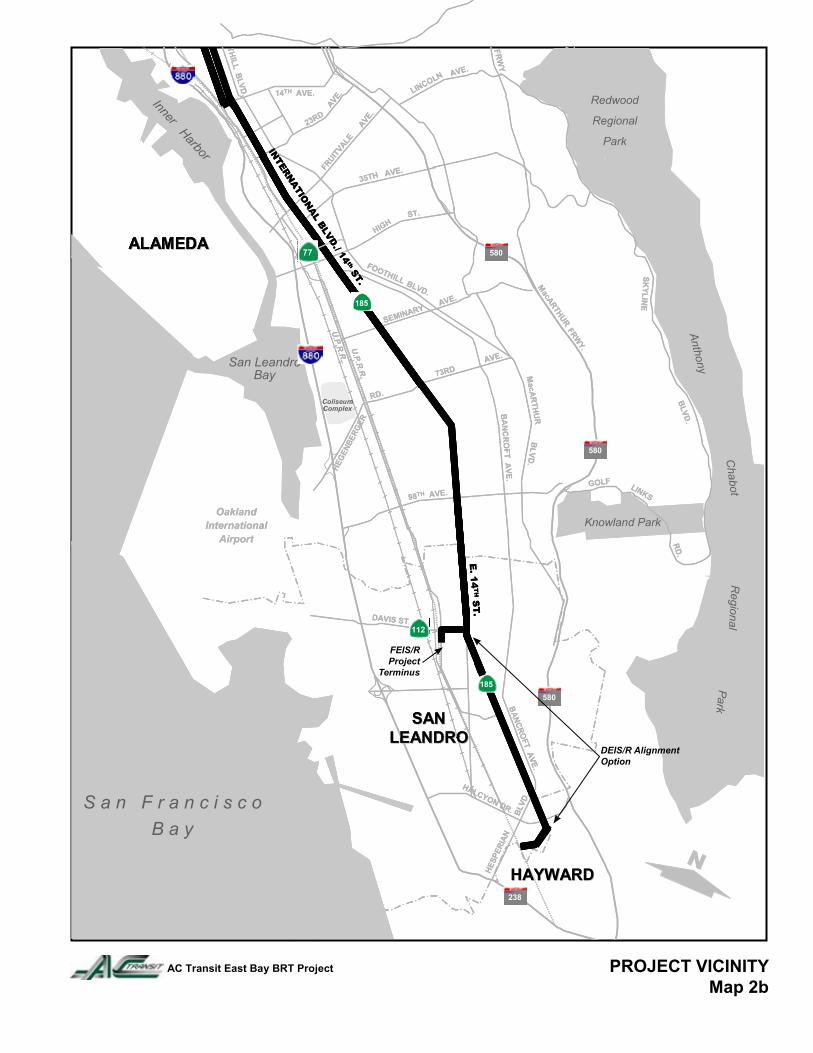
PROJECT VICINITYMap 2b
AC Transit East Bay BRT Project
FEIS/R Project
Terminus
DEIS/R Alignment Option
1
SUMMARY OF FINDINGS
The purpose of this document is to request concurrence from the State Office of Historic Preservation with regard to determinations of National Register eligibility or ineligibility for evaluated cultural resources and to document a proposed finding of “No Historic Properties Affected. The Alameda County (AC) Transit District proposes to upgrade bus service to a high-level express service, known as East Bay Bus Rapid Transit (EBBRT) along an approximately 18-mile arterial corridor through the cities of Berkeley, Oakland, San Leandro, California (Maps 1, 2a-2b). (Corridor length to BayFair BART is 18 miles; corri-dor length of revised project for FEIS terminating at San Leandro BART is 14.4 miles.) In 2004-2005, Archaeological/Historical Consultants carried out an archaeological survey and prepared an Archaeological Survey Report to encompass proposed alternative routes for the EBBRT Project (Baker 2005). At the same time JRP Historical Consulting carried out an historic property survey and prepared an Historic Properties Inventory and Evaluation Report (JRP Historical Consulting 2005). In 2010 final decisions have been made about project alternatives and a Preferred Alternative for the project was chosen. An Addendum Archaeological Survey Report (ASR) and Addendum Historic Properties Inventory and Evaluation Report (HRIER) were prepared in 2010 to address cultural resources in the new Area of Potential Effect (APE) that were not included in the 2005 reports. One new prehistoric archaeological site and 102 historical resources (i.e., those buildings, groups of buildings or structures that were constructed in or before 1965) are addressed in the addendum reports. Prehistoric archaeological site, P-01-010808, located in downtown Oakland in a deeply buried context, was recorded in 2006 based on newspaper accounts. It has not been formally evaluated because of its context. It can, however, be considered eligible or potentially eligible for the National Register under Criterion D, information potential, for purposes of the present undertaking only, if it is protected from any potential effects by the establishment and enforcement of an Environmentally Sensitive Area (ESA), in which cultural values are protected from adverse effects. The area of this site—Broadway between 13th and 14th Streets in Oakland, California—should be delineated as an ESA. An ESA action plan, probably involving archaeological monitoring during construction, should be developed for this and all other sites in the Preferred Alternative (see Baker 2005 for discussion of other areas of archaeological sensitivity). Of the 102 historical resources in the new alignment, eight are listed in the National Register or have been determined eligible for the National Register, or appear eligible for listing in the National Register. These properties are historical resources for the purposes of CEQA. The new APE also includes fourteen resources that do not appear to be eligible for the National Register but are listed or eligible for listing in a local register of historic resources; therefore they are considered historical resources for the purposes of CEQA. The remaining 80 survey population resources did not appear to meet the criteria
2
for listing in the National Register, nor do they appear to be historical resources for the purposes of CEQA. The Addendum ASR and Addendum HPIER are attached as Appendix 4 and Appendix 5 respectively. PROJECT LOCATION, DESCRIPTION, AND AREA OF POTENTIAL EFFECTS Project Location The project is located in the cities of Berkeley, Oakland, and San Leandro in Alameda County, California (Map 1). It is found on USGS 7.5’ Quadrangles Oakland West, Oakland East, and San Leandro.
In general from north to south, the Preferred Alternative begins in Downtown Berkeley, proceeds along the south side of the UC Berkeley campus to Telegraph Avenue, then along Telegraph Avenue to Downtown Oakland, then along International Boulevard to San Leandro. In San Leandro, the alignment runs along East 14th Street to Davis Street, then San Leandro Boulevard to San Leandro BART, on the west edge of downtown (Maps 1, 2a, 2b).
General Project Description
The Alameda County (AC) Transit District proposes to upgrade bus service to a high-level express service, known as Bus Rapid Transit (BRT) along an approximately 18-mile arterial corridor through the cities of Berkeley, Oakland, San Leandro, and portions of unincorporated Alameda County in the San Francisco Bay Area of California (See Maps 1, 2a-2b). The purpose of the AC Transit East Bay BRT Project is to improve existing fixed-route bus services in the study corridor and to increase transit ridership by providing faster transit travel times and attractive modern passenger facilities. The project will encompass both service and facilities improvements within the limits of existing public roadway rights-of-way to enhance bus service and encourage ridership along the Berkeley/Oakland/San Leandro corridor. Service improvements will include:
• Enhanced bus traffic signal priority through at-grade intersections; • Higher frequency bus service during most periods; • Off-vehicle, self service fare payment; • Enhanced “real time” passenger information systems at stations; • Level boarding of vehicles at stations; and • Faster, more reliable vehicle operations and thereby shorter passenger trip times.
Facilities improvements will include:
• Dedicated BRT travel lanes or BRT priority lanes in most areas;
3
• 47 passenger stations with full amenities, including shelters and benches, communications systems, ticket vending machines, lighting, and security/safety surveillance at key locations;
• BRT traffic control devices at signalized intersections; • Equipment and facilities performance monitoring systems; • Landscaping where space allows along the BRT transitway; and • Other roadway and pedestrian access improvements, primarily in station areas but
also at selected other locations where needed for the integration of BRT facilities. Physical impacts from the project will be within the project right-of-way, including the construction of 47 stations, and within the limits of present streets and sidewalks. BRT stations would be constructed either in the street median or along the outside curb – the latter designated as “curbside” stations. Median stations would serve transitways constructed in the middle of the street and would therefore not be affected by curb and sidewalk activities (e.g. parking maneuvers and pedestrian traffic).
The typical design width for median stations is 10 feet. Passenger access ramps would connect the platforms to pedestrian crosswalks at nearby intersections, sloping no more than 8 percent in conformance with the design requirements of ADA for the mobility impaired. A median station has two platforms, one serving each direction of travel. All stations would be on the right side of the transitway for right-side vehicle boarding.
Curbside stations would be integrated into existing facilities, such as sidewalks and pedestrian plazas, and platforms would extend into the street to serve BRT buses operating in the outside, or curbside, travel lane. Stations would typically be eight feet wide (e.g. extend out from the curb eight feet) and also a minimum of 10 inches above the top of the street pavement at the platform edge.
Vertical impacts from construction will generally be shallow except for areas of new utility emplacement.
For the purposes of description and analysis, the overall East Bay BRT project alignment has been divided into 11 segments. These segments were developed based on jurisdictional boundaries, neighborhood boundaries (specifically in Oakland), and sections with common design features. Segments and projected construction impacts are summarized below:
1. Berkeley: Shattuck Avenue to Telegraph Avenue; Telegraph Avenue from Bancroft Way/Blake Street to Woolsey Avenue.
No lane alterations or roadway improvements are proposed. To preserve reliability of BRT service in Oakland and San Leandro, and to provide convenience for Berkeley riders, intersections along the alignment will be upgraded with traffic signal prioritization (TSP).
2. North Oakland – Temescal and MacArthur: Telegraph Avenue from Woolsey Avenue to MacArthur Boulevard.
In this segment, buses would operate in center-running dedicated BRT lanes on Telegraph Avenue from the Berkeley/Oakland city limit at Woolsey to MacArthur
4
Boulevard. Southbound BRT begins just north of 66th Street. Northbound BRT ends just north of 65th Street and transitions to bus service in Berkeley.
There are six stations proposed in this segment, at the following locations, north to south:
• Telegraph Avenue at 65th Street (Alcatraz station) • Telegraph Avenue at McAuley/59th Street (59th Street station) • Telegraph Avenue at 55th Street (55th Street station) • Telegraph Avenue at 47th/48th Street (Temescal station) • Telegraph Avenue at 43rd Street (43rd Street station) • Telegraph Avenue at 39th Street (39th Street station)
The existing signal at 66th Street would be removed and a new traffic signal is proposed at 55th Street.
3. North Oakland – Pill Hill and Grand Avenue: Telegraph from MacArthur Boulevard to 20th Street/Uptown Transit Center.
This segment would remain generally consistent with the previous segment, with buses operating in center-running dedicated BRT lanes along Telegraph Avenue from MacArthur Boulevard to 20th Street.
There are four stations proposed in this segment, at the following locations, north to south:
• Telegraph Avenue at 36th Street (36th Street station) • Telegraph Avenue at 32nd/Hawthorne (Pill Hill station) • Telegraph Avenue at 29th Street (29th Street station) • Telegraph Avenue at 24th Street (Koreatown station)
New traffic signals are proposed at Hawthorne and Sycamore Streets. Pedestrian-only signals would be provided at both legs of 24th Street, near the Koreatown station. Leading into the Uptown station, a BRT-only signal phase would be provided at Telegraph and Broadway.
4. Central Oakland – Downtown and Chinatown: 20th Street to Lake Merritt, via 11th and 12th Streets. At 20th Street, both northbound and southbound BRT operates in mixed flow lanes between Telegraph and Broadway Avenues. At Broadway, the alignment shifts south. Southbound and northbound BRT operates in mixed flow lanes between 20th and 11th/12th Streets, with the exception of a northbound dedicated center-running lane that provides a left-turn movement onto 20th Street for buses only. Eleventh and 12th Streets would operate as a one-way pair, with the eastbound movement on 11th and the westbound movement on 12th. Each leg has a side-running dedicated BRT lane from Broadway Avenue to Oak Street. Past Oak Street, the dedicated BRT lanes transition to mixed flow lanes through the Lake Merritt area to 1st Avenue. There are five stations proposed in this segment, at the following locations, north to south:
5
• 20th Street at Telegraph/Broadway Avenue (Uptown station) • Broadway Avenue at 14th Street (14th Street station) • 11th/12th at Broadway Avenue (City Center station) • 11th/12th at Harrison Street (Harrison station) • 11th/12th at Madison Street (Madison station)
A new traffic signal is proposed at 11th Street and Alice Street. Through the Lake Merritt area, roadway improvements are proposed separate from this project, as part of the Lake Merritt Master Plan.
5. East Oakland – East Lake: International Boulevard from 1st Avenue to 14th Avenue.
The East Oakland segment picks up at 1st Avenue, with the eastbound BRT movement continuing along East 12th Street, and the westbound movement along International Boulevard. Both are accommodated in dedicated side-running BRT lanes. There are three proposed stations in this segment, at the following locations, north to south:
• International Boulevard/East 12th Street at 2nd Avenue (2nd Avenue station) • International Boulevard/East 12th Street at 5th Avenue (5th Avenue station) • International Boulevard/East 12th Street at 10th Avenue (10th Avenue station)
6. East Oakland – San Antonio: International Boulevard from 14th Avenue to 23rd Avenue. From the southbound alignment on East 12th street, the BRT turns north; operating in a shared BRT lane along 14th Avenue and for one block south of the intersection 14th Avenue/International Boulevard. At 15th Avenue, both northbound and southbound BRT operates in center-running dedicated BRT lanes. This continues through 23rd Avenue. There are two stations proposed in this segment, at the following locations, north to south:
• International Boulevard/East 12th Street at 14th Avenue (14th Avenue station) • International Boulevard at 20th Avenue (20th Avenue station)
7. East Oakland – Fruitvale: International Boulevard from 23rd Avenue to 42nd Avenue/SR 185. The East Oakland – The Fruitvale segment runs on International Boulevard from 23rd Avenue to 42nd Avenue/SR 185. There are five stations proposed in this segment, at the following locations, north to south:
• International Boulevard at Miller Avenue (23rd Avenue station) • International Boulevard at Mitchell Avenue (27th Avenue station) • International Boulevard at 31st Avenue (31st Avenue station)
6
• International Boulevard at 34th Avenue (Fruitvale station) • International Boulevard at 39th Avenue (39th Avenue station)
At 36th Avenue a landscaped median island is introduced and runs to 41st Avenue. New pedestrian signals would be installed at Miller Avenue, Mitchell Street, 28th, and 39th Avenues; and the intersections of 24th, 31st, and 36th Avenues would be pedestrian-only signals. 8. East Oakland – Central East: International Boulevard from 42nd Avenue to 73rd Avenue/Hegenberger Road. This segment continues on International Boulevard from 42nd Avenue to 73rd Avenue/Hegenberger Road. There are six stations proposed at the following locations, north to south:
• International Boulevard at High Street (High Street station) • International Boulevard at 48th Avenue (48th Avenue station) • International Boulevard at 54th Avenue (54th Avenue station) • International Boulevard at 58th Avenue (Seminary station) • International Boulevard at 66th Avenue (66th Avenue station) • International Boulevard at 72nd Avenue (72nd Avenue station)
New traffic signals would be installed at 50th, 52nd, 54th, 55th, and 57th Avenues. A new pedestrian signal would be installed at 48th Avenue. 9. East Oakland – Elmhurst: International Boulevard from 73rd Avenue/Hegenberger Road to Durant Avenue. This final Oakland segment continues on International Boulevard from 73rd Avenue/Hegenberger Road to Durant Avenue on the San Leandro border. Near Bristol Boulevard, International Boulevard is also knows as East 14th Street. There are six proposed stations in this segment at the following locations, north to south:
• International Boulevard at 78th Avenue (78th Avenue station) • International Boulevard at 82nd Avenue (82nd Avenue station) • International Boulevard at 87th Avenue (87th Avenue station) • International Boulevard at 94th Avenue (94th Avenue station) • International Boulevard at 99th Avenue (99th Avenue station) • International Boulevard at 104th Avenue (104th Avenue station)
New traffic signals would be installed at 78th, 81st, 92nd, and 100th Avenues. An existing traffic signal would be removed at 103rd Avenue. 82nd Avenue (west leg), Auseon/87th Avenue, and 99th Avenue would be a pedestrian only signal.
10. San Leandro North: International Boulevard/East 14th Street from Durant Avenue to Georgia Way.
7
The San Leandro – North Segment begins at Durant Avenue and continues to Georgia Way. BRT runs on dedicated lanes in this segment. There is one station proposed at the following locations:
• East 14th Street at Durant Avenue (Durant station)
New traffic signals would be installed at Bellview Drive and Sunnyside Drive, with a southbound bus queue jump leading into Sunnyside Drive
11. San Leandro – Civic Center and San Leandro BART: International Boulevard to Davis; to San Leandro BART. Beginning at Georgia Way, BRT would operate in mixed flow lanes alongside vehicular traffic. This configuration would continue to Davis Street, where the alignment would shift west along Davis and south again on San Leandro Boulevard, ending at the San Leandro BART station. There are four stations proposed in this segment, from north to south:
• East 14th Street at Georgia Way (Georgia Way station) • East 14th Street at Begier/Lorraine (Begier station) • Davis Street at Hays Street (Downtown San Leandro station) • San Leandro BART (San Leandro BART station)
Service from San Leandro BART to Bay Fair BART will be provided by an extension of the Route 99 bus, which currently runs from Bay Fair BART south to Hayward BART. Route 99 service will follow the current Route 1 alignment from San Leandro BART to Bay Fair BART. No physical improvements are proposed to be made to existing stops in this segment. Area of Potential Effect (APE) The APE for archaeology is the area of direct impact. It includes the project right-of-way along the corridor from downtown Berkeley to the San Leandro BART station as described above under Alignment. It is generally contained within current sidewalks, curbs and roadway (see APE for Archaeology, Figures 1-52 – Appendix 2). With regard to the APE for historical resources, the methodology for the original APE (JRP Historical Consulting 2005) was consistent with general cultural resource practices at that time and included those properties that would be subject to direct or indirect effects of the proposed project. In general, the original APE took in parcels immediately adjacent to new BRT stations, at locations where there were proposed alterations to existing sidewalks and curb-lines, or at locations of proposed construction of new traffic signals. The current standard practices for establishing an APE for BRT projects do not include parcels at all of these locations. These actions are no longer considered to pose an effect upon historic properties outside of the right-of-way because such construction would not cause a change in the character or setting of historic properties. Therefore, the only proposed project action that is assumed to have potential change to the setting of a
8
historic architectural resource is the construction of a BRT station. The new areas of potential effect covered by this Addendum HRIER includes adjacent parcels at all newly proposed BRT stations, even those completely within the existing curb-lines, because their construction will affect the over-all streetscape in each location, and may have the potential to obstruct the view of historic resources at their locations. In “downtown” locations of Berkeley or Oakland the new areas of potential effect was set to take in parcels on both sides of the street at BRT locations to account for the streetscape. In mixed residential/commercial areas (such as along Telegraph Avenue or along International Boulevard) the new areas of potential effect were set to take in parcels on the side of the street where the BRT station is to be located (see Architectural APE, Maps 3-54 – Appendix 3). CONSULTING PARTIES AND PUBLIC PARTICIPATION Interested parties were contacted for this project in 2005 through notification letters (Baker 2005; JRP Historical Consulting 2005). SUMMARY OF IDENTIFICATION EFFORTS Archaeological Research For the original Positive Archaeological Survey Report Archaeological/Historical Consultants researched and prepared prehistoric, ethnographic, and historic overviews (Baker 2005). The reader is referred to the 2005 report for details. The Northwest Information Center of the California Historical Resources Information Center at Sonoma State University, Rohnert Park, was contacted on February 25, 2010 for updated information on recorded archaeological sites and relevant reports submitted since the original 2005 record search (Baker 2010). The APE for the proposed project had not changed significantly for archaeological survey purposes from that described in Baker (2005) and is entirely included within the original record search, which included a study area up to one-half mile on either side of the project alignment. Only one prehistoric archaeological site—P-01-010808—had been newly recorded since 2005. This site, located in downtown Oakland, was recorded based on reports found in the San Francisco Chronicle dated July 1, 1928 and the Oakland Tribune dated May 23, 1967 (Schwartz 2006). The 1928 San Francisco Chronicle article (July 1, 1928) reported that a human burial was found during excavation for an elevator shaft in the basement of the Easton Building at 13th Street and Broadway. Bones were found approximately one foot beneath the concrete floor. In 1967 a “huge 50 pound mortar”, approximately 20” x 18” in size, was found during excavation of the 12th Street BART station. It was located between 13th and 14th Streets at about nine feet below street elevation (Oakland Tribune, May 23, 1967:8; Schwartz 2006).
9
The Northwest Information Center subsequently assigned the same site number to the two finds, apparently because their close proximity indicated the presence of one buried archaeological site (see Schwartz 2006). This location of the burial, however, is apparently the same as that of P-01-000042 (Ala-22), a number assigned quite some time ago to the Easton Building burial (Baker 2005:20). No archaeological sites within the project area are currently listed on the National Register of Historic Places (http://www.nps.gov/history/NR/research, accessed November 2010) or the California Register of Historical Resources and list of California Historical Landmarks (http://ohp.parks.ca.gov, accessed November 2010). Historic Research For the Addendum HPIE Report, JRP Historical Consulting conducted research in property records through First American Real Estate Solutions (FARES) commercial database, and also reviewed current and historic topographic and property maps, Alameda County assessment records, historic aerial photographs, and other documents including the results of previous documentation of historic properties (JRP Historical Consulting 2005). This determined which buildings, groups of buildings, structures, and objects would be studied in more detail as resources that appeared to have been built in or before 1965. JRP also undertook property-specific research for individual resources in both archival and published records. JRP staff conducted this research, both in conjunction with the fieldwork and after the field surveys were completed, between February and May 2010 and in October 2010. Research was conducted at California State Library, Sacramento; Shields Library, University of California, Davis; Caltrans Transportation Library, Sacramento; Caltrans District 4 Maps and Plans Office, Oakland; Alameda County Assessor’s Office, Alameda County Public Works Maps and Files Room (Hayward); Alameda County Building Permits; Berkeley Architectural Heritage Association; Berkeley Historical Society; Berkeley History Room, Berkeley Public Library; Environmental Design Library, University of California, Berkeley; Earth Sciences Map Library, University of California, Berkeley; City of Berkeley, Permit Service Center; Oakland Cultural Heritage Survey, Oakland Building Services-Permit Center, Oakland History Room, Main Oakland Library; San Leandro History Room, San Leandro Main Library, and City of San Leandro Planning Office and Permit Center. As part of the process to identify historic resources within the APE, JRP reviewed existing information from previous surveys. JRP reviewed the National Register, California Register, California Historical Landmarks, and the California Points of Historic Interest lists to assess the location of known historic properties within the APE. JRP also examined previous historic resource inventory and evaluation surveys and reports. Given that there has long been a strong historic preservation presence in Oakland, JRP found many historic resource inventory and evaluation records on properties within the APE. JRP located most of the previous studies at Oakland Cultural Heritage Survey.
10
Addendum Cultural Resources Surveys Archaeological Survey The survey methodology for the original APE for the BRT project was and is consistent with general cultural resources practices. The 2004-2005 archaeological survey included an on-foot inspection of the APE for archaeology within all alternative alignments for the project, including the Preferred Alternative discussed in the Addendum Archaeological Survey Report (Baker 2005. The BRT project will be mainly constructed within existing streets, with most proposed construction between curbs. In addition, the project alignment passes through a highly built environment with little open space adjacent to the alignment. Nevertheless, the streetscape includes open parkways, open tree planting areas, adjacent lawns and planters, and occasionally a vacant lot. Aside from the record search which pinpointed already recorded sites and historic areas, the only way to determine if sensitive locations existed within or adjacent to the project alignment was to walk the alignment and inspect adjacent open areas. Both sides of the entire length of the proposed alternative alignments, including the Preferred Alternative, were inspected on foot in 2004-2005. Sidewalk cuts for tree plantings, planters, parkways, adjacent yards, and, where possible, adjacent vacant lots were inspected for evidence of cultural modification, including shell, midden soil, lithic debitage, groundstone, and historic artifacts and features. In addition, the locations of nearby previously reported sites were intensively inspected. The detailed results of the 2004-2005 archaeological survey are reported in Baker (2005). All areas within the APE of the Preferred Alignment were inspected in 2005. No additional archaeological survey was deemed necessary for this Addendum ASR (Baker 2010 – see Appendix 4, this HPSR). Historic Property Survey Although resources evaluated for the National Register and California Register programs are usually 50 years old or older, the addendum historic property survey included all resources within the APE that were 45 years old or older as of 2010 to account for the passage of time between the period of project review and project completion. Buildings, structures, and objects determined to have been built in 1966 or later and which did not meet the exacting requirements for recently constructed buildings as specified in National Register Criteria Consideration G, were considered non-historic and required no further study (JRP Consulting 2010; see Appendix 5, this HPSR). Of the 133 parcels within the new APE, 102 contain survey population resources, i.e. buildings, group of buildings, structures or objects constructed in or before 1965. Eleven parcels contained buildings or structures constructed in or after 1966 and twenty properties were vacant at the time of the survey. In keeping with the guidance and
11
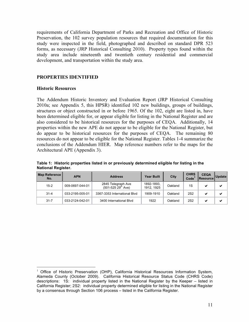
requirements of California Department of Parks and Recreation and Office of Historic Preservation, the 102 survey population resources that required documentation for this study were inspected in the field, photographed and described on standard DPR 523 forms, as necessary (JRP Historical Consulting 2010). Property types found within the study area include nineteenth and twentieth century residential and commercial development, and transportation within the study area. PROPERTIES IDENTIFIED Historic Resources The Addendum Historic Inventory and Evaluation Report (JRP Historical Consulting 2010a; see Appendix 5, this HPSR) identified 102 new buildings, groups of buildings, structures or object constructed in or before 1965. Of the 102, eight are listed in, have been determined eligible for, or appear eligible for listing in the National Register and are also considered to be historical resources for the purposes of CEQA. Additionally, 14 properties within the new APE do not appear to be eligible for the National Register, but do appear to be historical resources for the purposes of CEQA. The remaining 80 resources do not appear to be eligible for the National Register. Tables 1-4 summarize the conclusions of the Addendum HIER. Map reference numbers refer to the maps for the Architectural APE (Appendix 3). Table 1: Historic properties listed in or previously determined eligible for listing in the National Register. Map Reference
No. APN Address Year Built City CHRS Code1
CEQA Resource Update
15-2 009-0697-044-01 2845 Telegraph Ave (501-525 29th Ave)
1892-1893, 1912, 1925 Oakland 1S
31-4 033-2195-005-01 3367-3353 International Blvd 1909-1910 Oakland 2S2
31-7 033-2124-042-01 3400 International Blvd 1922 Oakland 2S2
1 Office of Historic Preservation (OHP), California Historical Resources Information System, Alameda County (October 2009). California Historical Resource Status Code (CHRS Code) descriptions: 1S: individual property listed in the National Register by the Keeper – listed in California Register; 2S2: individual property determined eligible for listing in the National Register by a consensus through Section 106 process – listed in the California Register.
12
Table 2: Historic properties that appear to be eligible for listing in the National Register. Map Reference
No. APN Address Year Built City CHRS Code2
CEQA Resource Update
09-2 014-1221-002-07 5427-5429 Telegraph Ave 1933 Oakland 3S
15-3 009-0697-049 2831 Telegraph Ave ca. 1895 Oakland 3S
20-1 002-0071-001 250 10th St 1853-1976 Oakland 3S
22-1 020-0125-007 1247 5th Ave (449 International Blvd) ca. 1910 Oakland 3S
36-3 041-3848-004-01 5701-5725 International Blvd 1927 Oakland 3B
Table 3: Historic properties that do not appear eligible for listing in the National Register but are of local interest. Map Reference
No. APN Address Year Built City CHRS Code3
CEQA Resource Update
11-4 013-1095-005 4301-4305 Telegraph Ave 1924 Oakland 5S2, 6Z 11-5 013-1097-028-01 4216-4238 Telegraph Ave 1924 Oakland 5S2, 6Z 17-1 008-0649-008 466-472 20th Street 1913, 1950 Oakland 5S2, 6Z 28-1 020-0153-010 2336 International Blvd 1880c Oakland 5S2, 6Z 28-2 020-0153-009-01 2338-2344 International Blvd 1926 Oakland 5B, 6Z 31-1 033-2195-002 3313-3315 International Blvd 1908-1909 Oakland 5S2, 6Z 31-2 033-2195-003 3323-3333 International Blvd 1908-1909 Oakland 5S2, 6Z 31-5 033-2196-021-05 3401-3407 International Blvd 1928 Oakland 5B, 6Z 31-6 033-2196-003-02 3419 International Boulevard 1915 Oakland 5D2,
5S2, 6Z 31-9 033-2124-040 3416-3418 International Blvd 1908 Oakland 5S2, 6Z 31-10 033-2124-039 3420-3422 International Blvd 1924 Oakland 5D2, 6Z 32-5 033-2157-004-04 3851-3871 International Blvd 1927 Oakland 5S2, 6Z 34-3 035-2361-026 4810 International Blvd 1925 Oakland 5S2, 6Z 44-5 044-4967-003 9415 International Blvd 1923-1924 Oakland 5B, 6Z
2 Office of Historic Preservation (OHP), CHRS Code descriptions: 3S: appears eligible for the California Register as an individual property. 3 Office of Historic Preservation (OHP). CHRS Code descriptions: 5B: locally significant (listed, eligible or appears eligible) both individually and as a contributor to a district that is locally listed, designated, determined eligible or appears eligible; 5D2: appears to be a contributor to a district that appears eligible for local listing or designation; 5S2: individual property that is eligible for local listing or designation; 6Z: found ineligible for National Register, California Register, or local designation.
13
Table 4: Historic properties that do not appear eligible for listing in the National Register, are not of local interest, and do not appear to be historical resources for the purposes of CEQA.
Map Reference No. APN Address Year Built City CHRS
Code4 CEQA
Resource Update
01-1 055-1886-004 2241 Durant Ave 1911-1920 Berkeley 6Z 01-2 055-1887-001 2298 Durant Ave 1901 Berkeley 6Z 04-1 054-1713-001-
01 2700 Regent Street 1965 Berkeley 6Z
04-2 054-1712-006-01 2455 Stuart Street 1957, 1980 Berkeley 6Z
04-3 054-1714-006 2716 Telegraph Avenue 1904 Berkeley 6Z 04-4 054-1714-007 2718 Telegraph Avenue 1962 Berkeley 6Z 04-5 054-1714-008 2407-2411 Ward Street 1924 Berkeley 6Z 04-6 054-1716-001 2730 Telegraph Avenue 1958 Berkeley 6Z 05-1 052-1577-001-
01 3000 Telegraph Ave 1957 Berkeley 6Z 06-1 016-1424-017 6511-6515 Telegraph Ave 1953-1954 Oakland 6Z 06-2 016-1424-018 6501-6505 Telegraph Ave 1909 Oakland 6Z 06-3 016-1424-019-
02 6435-6437 Telegraph Ave 1908 Oakland 6Z 06-4 016-1415-026 6436 Telegraph Ave 1925 Oakland 6Z 07-1 016-1386-014-
01 5928 Telegraph Ave 1907 Oakland 6Z 07-2 015-1383-005 5939 Telegraph Ave 1950 Oakland 6Z 08-1 016-1386-012-
03 5914 Telegraph Ave 1908 Oakland 6Z 08-2 016-1386-011 5900 Telegraph Ave 1912 Oakland 6Z 08-3 016-1386-011 490 59th St 1906 Oakland 6Z 08-4 015-1383-006 5929-5931 Telegraph Ave 1908, 1928 Oakland 6Z 08-5 015-1383-007 5915 Telegraph Ave 1957 Oakland 6Z 09-1 014-1221-027-
01 5447 Telegraph Ave 1904-1913 Oakland 6Z, 6Y
10-1 013-1156-003-01 4725-4727 Telegraph Ave 1906 Oakland 6Z, 6Y
10-10 013-1150-019-02 495-497 48th Street 1904 Oakland 6Z
10-2 013-1156-004 4721-4723 Telegraph Ave 1914 Oakland 6Z 10-3 013-1156-004 4720 Shattuck Ave ca. 1911 Oakland 6Z
4 Office of Historic Preservation (OHP). CHRS Code descriptions: 6Z: found ineligible for National Register, California Register, or local designation through survey evaluation; 6L: determined ineligible for the National Register by consensus through Section 106 process – not evaluated for the California Register of local listing. [OHP, Technical Assistance Bulletin # 8: User’s Guide to the California Historical Resource Status Codes and Historic Resource Inventory Directory.]
14
Map Reference No. APN Address Year Built City CHRS
Code4 CEQA
Resource Update
10-4 013-1156-005 4715 Telegraph Ave 1956 Oakland 6Z 10-5 013-1156-006 4704-4706 Shattuck Ave 1897 Oakland 6Z 10-6 013-1156-006 4707 Telegraph Ave 1909 Oakland 6Z 10-7 013-1156-007 4701-4703 Telegraph Ave 1907 Oakland 6Z 10-8 013-1150-019-
02 4760-4770 Telegraph Ave 1904 Oakland 6Z
10-9 013-1150-019-02 4744-4750 Telegraph Ave 1904 Oakland 6Z
11-1 013-1095-002 4343-4345 Telegraph Ave 1934 Oakland 6Z 11-2 013-1095-004-
01 4311-4315 Telegraph Ave 1951 Oakland 6Z
11-3 013-1095-004-01 4307 Telegraph Ave 1965 Oakland 6Z
15-1 009-0699-012-01 2900-2914 Telegraph Ave 1922 Oakland 6Z
25-1 020-0142-005-02; 020-0142-
005-03 1350 International Blvd 1957 Oakland 6Z
25-2 020-0115-001 1401 International Blvd 1930 Oakland 6Z 26-1 020-0109-001 2001-2003 International
Boulevard ca. 1940 Oakland 6Z 26-2 020-0109-002 2009 International Blvd 1932 Oakland 6Z 26-3 020-0109-003 2015-2017 International Blvd ca. 1890 Oakland 6Z 26-4 020-0149-010 2040-2048 International Blvd 1926 Oakland 6Z 28-3 020-0153-008 2348-2352 International Blvd 1913 Oakland 6Z 28-4 020-0104-002 2411 International Blvd 1920 Oakland 6Z 29-1 025-0713-012 2750-2758 International Blvd ca. 1923 Oakland 6Z 31-11 033-2124-038 3428-3432 International Blvd 1910 Oakland 6Z 31-12 033-2124-037-
01 3444 International Blvd 1961 Oakland 6Z 31-3 033-2195-004 3347-3349 International Blvd 1909-1910 Oakland 6Z 31-8 033-2124-041-
03 3410 International Blvd 1924 Oakland 6Z 32-1 033-2138-015 3842-3846 International Blvd 1912 Oakland 6Z, 6Y 32-2 033-2138-015 3846 International Blvd 1906 Oakland 6Z 32-3 033-2138-014-
01 3848-3852 International Blvd 1919 Oakland 6Z
32-4 033-2138-014-01 3860-3872 International Blvd 1908 Oakland 6Z
34-1 034-2256-001 4801-4805 International Blvd 1922 Oakland 6Z 34-2 035-2360-017 4774- 4778 International
Blvd 1908 Oakland 6Z 34-4 035-2361-025 4814 International Blvd 1946 Oakland 6Z 34-5 034-2256-003 4819 International Blvd 1940 Oakland 6Z 34-6 034-2256-004-
01 4825 International Blvd 1920c,1946 Oakland 6Z
15
Map Reference No. APN Address Year Built City CHRS
Code4 CEQA
Resource Update
36-1 035-2366-022-03 5424 International Blvd 1912, 1946 Oakland 6Z
36-2 034-2275-008 5337 International Blvd 1922 Oakland 6Z 36-4 038-3234-016 5730-5732 International Blvd 1911 Oakland 6Z 36-5 038-3234-015 5744-5746 International Blvd 1920 Oakland 6Z 38-1 041-4054-005 1208 65th Ave 1939-1941 Oakland 6Z 43-1 043-4581-013-
01 8650-8654 International Blvd 1923 Oakland 6Z 43-2 043-4581-011 8670 International Blvd 1949 Oakland 6Z 43-3 042-4252-006 8629 International Blvd 1946 Oakland 6Z 43-4 042-4252-007 8633-8639 International Blvd 1946 Oakland 6Z 44-1 046-5422-019-
02 9328-9334 International Blvd ca. 1897-1905 Oakland 6Z
44-2 046-5422-017-02
9340 & 9348 International Blvd ca. 1893 Oakland 6Z
44-3 044-4967-001 9401-9403 International Blvd ca. 1905-1910 Oakland 6Z
44-4 044-4967-002 9409 International Blvd 1937 Oakland 6Z 48-1 076-0271-017-
04 110 E 14th St 1940, 1946 San Leandro 6Z
48-2 076-0276-028 464 E 14th St 1948 San Leandro 6Z
48-3 076-0276-027 484-496 E 14th St ca. 1918-1922
San Leandro 6Z
48-4 075-0181-004 445 E 14th St ca. 1938-1946
San Leandro 6Z
48-5 075-0181-005 455-459 E 14th St 1928-1946 San Leandro 6Z
48-6 075-0181-006 471 E 14th St 1945 San Leandro 6Z
48-7 075-0181-007 485 E 14th St 1941 San Leandro 6Z
48-8 075-0181-008 497-499 E 14th St 1933 San Leandro 6Z
49-1 076-0414-033 852 E 14th St 1910 San Leandro 6Z
49-2 076-0414-032 858 E 14th St ca. 1912 San Leandro 6Z
Archaeological Resources Only one new archaeological site has been recorded within the APE for the Preferred Alternative since 2005: P-01-010808. This site number has been given to the locations of two prehistoric remains found in close proximity. One is a large prehistoric mortar found on Broadway nine feet below street level during excavation of the 12th Street BART Station in 1967. The other is a prehistoric human burial found in 1928 at 13th and Broadway one foot
16
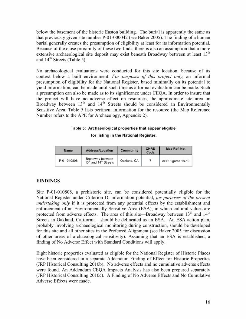
below the basement of the historic Easton building. The burial is apparently the same as that previously given site number P-01-000042 (see Baker 2005). The finding of a human burial generally creates the presumption of eligibility at least for its information potential. Because of the close proximity of these two finds, there is also an assumption that a more extensive archaeological site deposit may exist beneath Broadway between at least 13th and 14th Streets (Table 5). No archaeological evaluations were conducted for this site location, because of its context below a built environment. For purposes of this project only, an informal presumption of eligibility for the National Register, based minimally on its potential to yield information, can be made until such time as a formal evaluation can be made. Such a presumption can also be made as to its significance under CEQA. In order to insure that the project will have no adverse effect on resources, the approximate site area on Broadway between 13th and 14th Streets should be considered an Environmentally Sensitive Area. Table 5 lists pertinent information for the resource (the Map Reference Number refers to the APE for Archaeology, Appendix 2).
Table 5: Archaeological properties that appear eligible
for listing in the National Register.
Name Address/Location Community CHRS Code
Map Ref. No.
P-01-010808 Broadway between 13th and 14th Streets Oakland, CA 7
ASR Figures 18-19
FINDINGS Site P-01-010808, a prehistoric site, can be considered potentially eligible for the National Register under Criterion D, information potential, for purposes of the present undertaking only if it is protected from any potential effects by the establishment and enforcement of an Environmentally Sensitive Area (ESA), in which cultural values are protected from adverse effects. The area of this site—Broadway between 13th and 14th Streets in Oakland, California—should be delineated as an ESA. An ESA action plan, probably involving archaeological monitoring during construction, should be developed for this site and all other sites in the Preferred Alignment (see Baker 2005 for discussion of other areas of archaeological sensitivity). Assuming that an ESA is established, a finding of No Adverse Effect with Standard Conditions will apply. Eight historic properties evaluated as eligible for the National Register of Historic Places have been considered in a separate Addendum Finding of Effect for Historic Properties (JRP Historical Consulting 2010b). No adverse effects and no cumulative adverse effects were found. An Addendum CEQA Impacts Analysis has also been prepared separately (JRP Historical Consulting 2010c). A Finding of No Adverse Effects and No Cumulative Adverse Effects were made.
17
REFERENCES Baker, Suzanne 2005 Positive Archaeological Survey Report for the Alameda-Contra Costa Transit District’s East Bay Bus Rapid Transit Project in Berkeley, Oakland, and San Leandro. Prepared for Parsons, San Francisco. JRP Historical Consulting 2005 Historic Properties Inventory and Evaluation: AC Transit East Bay Bus Rapid Transit Project. Submitted to Parsons, San Francisco. JRP Historical Consulting 2010a Draft Addendum Historic Properties Inventory and Evaluation: AC Transit East Bay Bus Rapid Transit Project. Vols. 1 and 2. Submitted to Kimley-Horn and Associates, Inc., Oakland. 2010b Draft Addendum Finding of Effect, AC Transit East Bay Bus Rapid Transit Project. Submitted to Kimley-Horn and Associates, Inc. Oakland. 2010c Draft Addendum CEQA Impacts Analysis, AC Transit East Bay Bus Rapid Transit Project. Submitted to Kimley-Horn and Associates, Inc. Oakland. Oakland Tribune 1967 (May 23) “Old Jar Found in Subway Trench.” On file, Northwest Information Center, California Historic Resources Information System, Sonoma State University, Rohnert Park, CA. San Francisco Chronicle 1928 (July 1) “Burial Ground of Indians Believed Found in Oakland. On file, Northwest Information Center, California Historic Resources Information System, Sonoma State University, Rohnert Park, CA. Schwartz, Richard 2006 Archaeological Site Record, P-01-010808. On file, Northwest Information Center, California Historic Resources Information System, Sonoma State University, Rohnert Park, CA.