Embed Size (px)
Citation preview

Abstract Booklet

2015 ILRS Technical Workshop
1 GNSS session A: Synergy of SLR and GNSS Data Products 1.1 ITRF2014: Preliminary results and ILRS contribution
Z. Altamimi, P. Rebischung, L. Métivier, X. Collilieux
1.2 SLR on GPS III Thomas Johnson
1.3 GLONASS-M Satellite Geometry and Attitude Models for Precise GNSS Data Processing R. Fatkulin, S. Revnivykh, V. Mitrikas, V. Pasynkov
1.4 SLR measurements and their importance for Galileo W. Enderle, D. Navarro-Reyes, F. Gonzalez, E. Schoenemann, R. Zandbergen
1.5 SLR global tracking of Beidou and its needs for SLR Xiaoya Wang, Xiaogong Hu, Bing He, Qunhe Zhao, Bin Wu, Zhongping Zhang
1.5b Role of SLR on QZSS operation Yoshimi Ohshima
1.6 SLR data usage in the verification of GLONASS data processing methods. IAC PNT analysis of GLONASS SLR data in LARGE experiment. V. Glotov, A. Pafnutyev, M. Zynkovsky, V. Mitrikas
1.7 Using SLR for GNSS orbit model validation C. Flohrer, T. Springer, M. Otten, C. Garcia Serrano, F. Dilssner, W. Enderle, E. Schönemann
1.8 Orbit Validation On Navigation Satellites Using Satellite Laser Ranging Gang Zhao, Xuhua Zhou
1.9 Systematic effects in SLR measurements to GNSS satellites K. Sośnica, R. Dach, D. Thaller, A. Maier, D. Arnold, L. Prange, A. Jäggi
1.10 SLR in the framework of the EGSIEM project A. Maier , A. Sušnik , D. Arnold , K. Sosnica , U. Meyer , R. Dach , A. Jäggi
1.11 Phases Ambiguities Resolution Combining Precise Point Positioning (PPP) and SBAS Augmentation Methods Noureddine Kheloufi
1.12 Satellite radio laser ranging stations for GNSS application: requirements for technical characteristics and methods of their implementation M.A. Sadovnikov, V.D. Shargorodskiy
1.13 POD improvements of GNSS satellites through the measurements of their non-gravitational accelerations by means of an onboard accelerometer D. M. Lucchesi, E. Fiorenza, C. Lefevre, M. Lucente, C. Magnafico, R. Peron, F. Santoli and V. A. Iafolla
1.14 An SLR campaign on Galileo satellites 5 and 6 for a test of the gravitational redshift P. Delva , F. Deleflie , P. Exertier and S. Loyer

2015 ILRS Technical Workshop
2 GNSS session B: ILRS Network Performance and Improvement 2.1 Summary of Results from ILRS GNSS Tracking Campaigns
C. Noll , M. Pearlman, M. Torrence
2.2 Preliminary results of Russian laser ranging network performance in the third GNSS tracking campaign Pasynkov V.V., Sadovnikov M.A., Shargorodskiy V.D., Zhukov A.N.
2.3 Recent SLR tracking improvements at Herstmonceux G.Appleby, C.Potter, J.Rodriguez, R.Sherwood, V.Smith, T.Shoobridge, M.Wilkinson.
2.4 Maximizing the output of SLR station Graz: Tracking 140 targets Georg Kirchner, Franz Koidl
2.5 Theoretical Performance of NASA’s SGSLR System Ranging to GNSS Satellites John Degnan
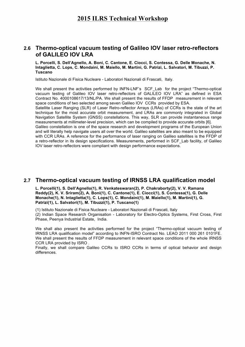
2.6 Thermo-optical vacuum testing of Galileo IOV laser retro-reflectors of GALILEO IOV LRA L. Porcelli, S. Dell’Agnello, A. Boni, C. Cantone, E. Ciocci, S. Contessa, G. Delle Monache, N. Intaglietta, C. Lops, C. Mondaini, M. Maiello, M. Martini, G. Patrizi, L. Salvatori, M. Tibuzzi, P. Tuscano
2.7 Thermo-optical vacuum testing of IRNSS LRA qualification model L. Porcelli, S. Dell’Agnello, R. Venkateswaran, P. Chakraborty, V. V. Ramana Reddy, K. V. Sriram, A. Boni, C. Cantone, E. Ciocci, S. Contessa, G. Delle Monache, N. Intaglietta, C. Lops, C. Mondaini, M. Maiello, M. Martini, G. Patrizi, L. Salvatori, M. Tibuzzi, P. Tuscano
2.8 Retroreflector Array for an Eccentric Orbit D. Arnold
2.9 The COPERNICUS Sentinel-3 mission J. Fernández, F. Ayuga , P. Féménias , H. Peter
2.10 INRRI-EDM/2016: the First Laser Retroreflector Payload on Mars Delle Monache G.,Dell’Agnello S., Vittori R., Porcelli L., Tibuzzi M., Boni A., Intaglietta N., Salvatori L., Tuscano P., Ciocci E., Martini M., Contessa S., Patrizi G., Mondaini C., Lops C., Maiello M., Bianco G., Cantone C.

2015 ILRS Technical Workshop
3 Space Debris session 3.1 Laser ranging initiatives at ESA in support of operational needs and space surveillance
and tracking T. Flohrer, H. Krag
3.2 Light Curve Measurements with Single Photon Counters at Graz SLR Georg Kirchner, Franz Koidl, Michael Steindorfer, Wang Peiyuan
3.3b Zimmerwald Laser Observations to Determine Attitude States of Space Debris T. Schildknecht, J-N. Pittet, J. Silha, M. Prohaska, M. Ploner
3.4 Orbital Debris Laser Ranging Station Stuttgart D. Hampf, W. Riede, P. Wagner, F. Sproll, L. Humbert
3.5 The Application of Superconducting Nanowire Single-photon detector in Laser Ranging and Preliminary Measuring Results Zhang Zhongping,Meng Wendong,Wu Zhibo,Zhang Haifeng,Li Pu,Deng Huarong
3.6 Review of Solid State Photon Counters for Laser Tracking of Orbital Space Debris I. Prochazka, J. Kodet, J. Blazej, G. Kirchner , F. Koidl
3.7 MORAL: Alt-Azimuth one meter class mount for SLR N.Bellini, S.Naldi, D.Rastelli, M.Valdatta
3.8 SP-DART: Single-Photon Detection, Alignment and Reference Tool Georg Kirchner, Franz Koidl, Michael Steindorfer, Wang Peiyuan
3.8b Space Debris Tracking in Changchun Observatory DONG Xue, Han Xingwei, Fan Cunbo, SONG Qingli
3.8c Space Debris Ranging Data Orbit Determination LIANG Zhipeng, LIU Chengzhi, FAN Cunbo, HAN Xingwei
4 Time Transfer session 4.1 All Optical Time and Frequency Distribution for Space Geodesy
U. Schreiber , J. Kodet , J. Eckl , G. Herold , G. Kronschnabl , C. Plötz , A.Neidhardt
4.2 Why Geodesy Needs Time! Anja Schlicht
4.3 Requirements on SLR System for Participation in ELT and Future Laser Time Transfer Experiments I. Prochazka , J. Kodet , J. Blazej
4.4 Collation and transfer of time scales with sub-nanosecond accuracy by laser range and pseudo-range measurements V.D. Shargorodskiy, M.V. Baryshnikov, M.A. Sadovnikov,
4.5 Synchronization of distant Laser stations thanks to Time Transfer by Laser Link : Proposal for a dedicated campaign A. Belli , P. Exertier , E. Samain , C.Courde , J.M.Torre , F. Vernotte
4.6 Satellite Quantum Communications exploiting SLR at MLRO

2015 ILRS Technical Workshop
G. Vallone, D. Dequal, M. Tomasin, F. Vedovato, M. Schiavon, V. Luceri, G. Bianco and P. Villoresi
5 System Biases session A: Analytic Results 5.1 Systematic range error 2014-2015
T. Otsubo
5.2 Impact of range biases on global reference frames H. Mueller, M. Blossfeld
5.3 ILRS Stations' range biases revealed by a 20-year analysis of LAGEOS observations 1993-2014 G.M.Appleby, J.C. Rodriguez Perez
6 System Biases session B: station issues 6.1 Improving the Local Ties of a Fundamental Station by a Multi-Technique Ground
Target J. Kodet , U. Schreiber , J. Eckl , G. Herold , G. Kronschnabl , C. Plötz , A.Neidhardt , S. Mähler , T. Schüler , T. Klügel
6.2 Single Photon Tracking under difficult Condition J. J. Eckl , K. U. Schreiber
6.3 Analysis of Yunnan Observatories' 1.2m Telescope Laser Ranging System Biases Li Zhulian,Zhai Dongsheng,Fu Honglin,Li Rongwang,Li Yuqiang,He Shaohui,Zhang Yuncheng,Xiong Yaoheng
6.4 SLR Station Biases Ivan Prochazka

2015 ILRS Technical Workshop
1 GNSS session A: Synergy of SLR and GNSS Data Products Chairs: E. Pavlis, D. Thaller, C. Noll, V. Glotov
1.1 ITRF2014: Preliminary results and ILRS contribution Z. Altamimi, P. Rebischung, L. Métivier, X. Collilieux
IGN France The ITRF2014 is expected to be more robust and accurate than past ITRF versions, by precisely modeling and estimating non-linear station motions, including periodic signals and post-seismic deformation following major Earthquakes. The paper highlights some preliminary results of the ITRF2014, evaluates the performance of the ILRS contribution, and assesses the level of agreement between terrestrial local tie measurements and space geodesy estimates, focussing on SLR-GNSS co-locations.
1.2 SLR on GPS III Thomas Johnson
National Geospatial-Intelligence Agency After years of efforts, the US Air Force Space Command agreed to allow satellite laser ranging to GPS III satellites to support new geodetic requirements. This presentation will review these geodetic requirements, the status of the Laser Retro-reflector Array development, plans for integration, needed studies, thoughts on schedules, and level of ILRS support. Fortunately, the scientific community has plenty of time to plan for GPS III and how best achieve the 1 mm reference frame through the support of GNSS and other missions.

2015 ILRS Technical Workshop
1.3 GLONASS-M Satellite Geometry and Attitude Models for Precise GNSS Data Processing R. Fatkulin(1), S. Revnivykh(1), V. Mitrikas(2), V. Pasynkov(3)
(1) ISS-RESHETNEV Corporation (2) IAC PNT TsNIImash (3) NPK SPP GLONASS constellation is based on Glonass-M satellite and will continue to keep such status up to end of this decade. The geometry and attitude model of the satellites are critical information for the processing of data from GLONASS constellation in precise orbit and clock determination and precise point positioning (PPP) applications. The presentation gives inputs on the main parameters for Glonass-M satellite, which are used at the data processing and monitoring centers: spacecraft body frame, and labeling of the principal spacecraft axes; spacecraft body geometry and dimensions; position of the on-board antenna phase center relative to the satellite center of mass; laser retroreflector array coordinates. The introduced data are so called ˜design parameters’ to be used as a priori data and must be a subject of further refinement during GNSS and SLR data processing and ground calibration. The satellite attitude model obtained based on long-term data processing of the global network. This model properly suites to the actual satellite behavior to be applied for precise calculations. The introduced data shall be also updated when a satellite structure changed.
1.4 SLR measurements and their importance for Galileo W. Enderle(1), D. Navarro-Reyes(2), F. Gonzalez(2), E. Schoenemann(1), R. Zandbergen(1)
(1) ESA / European Space Operations Centre (ESOC), Darmstadt, Germany (2) ESA / European Space Research and Technology Centre (ESTEC), Noordwijk, The Netherlands This presentation by the European Space Agency will demonstrate the importance of SLR measurements for ESA and in particular for the Galileo project, to independently validate operational products. SLR measurements are used routinely in the frame of the Orbit Validation Facility (OVF), which is part of the Time and Geodesy Validation Facility (TGVF) of Galileo. The OVF is responsible for the generation of the Galileo Terrestrial Reference Frame (GTRF) and the provision of Galileo validation products such as orbit and clock solutions of the highest possible accuracy. SLR measurements offer the possibility to independently validate the L-band based orbit and clock products and to reveal remaining orbit and clock modelling problems. Thus, SLR measurements are very well suited for the development, analysis and validation of satellite force models. In this presentation SLR measurements will be used to demonstrate the correlation of radial orbit and clock errors and, referring to the work of Flohrer et al., to prove the validity of the Galileo Box-Wing model, which is used to correct for the effect of the solar radiation pressure acting on the satellite surface. Finally the presentation will address the differences between Galileo IOV and FOC satellites and give an overview of the next steps in the Galileo development and different upcoming ESA studies, for which the availability of SLR measurements would mean a great benefit.

2015 ILRS Technical Workshop
1.5 SLR global tracking of Beidou and its needs for SLR Xiaoya Wang, Xiaogong Hu, Bing He, Qunhe Zhao, Bin Wu, Zhongping Zhang
Shanghai Astronomical Observatory, Chinese Academy of Sciences There are 16 satellites in service since the first Beidou experimental satellite launched in 2007. They are all installed by laser reflector array and tracked by SLR. What can SLR do for Beidou? First of all it is used to provide an evaluation of Beidou orbits based on microwave measurements. On the one hand we can know the GNSS orbit accuracy by SLR observation; on the other hand we can choose better orbit determination method and better models such as solar pressure, phase center models and so on. The second one is GNSS needs TRF and EOP. SLR can make an important role for TRF and EOP. Especially the addition of more good GNSS there are more new sites which needs high accuracy position and velocity. Most of them are determined only based on GNSS. For consistence they should be imported in the 4-technique combined processing and give a better results. Moreover, more good GNSS can provide a better TRF and EOP. The third one is to check system errors between different techniques. This is more important for new GNSS systems. For co-location sites there are some different residuals which show we miss some errors in data analysis. The fourth one is SLR can provide optical orbits. It is useful for orbit cross check with GNSS microwave orbits. Certainly, SLR could provide more products such as gravity information, geocentric motion and so on. They are also important for GNSS and other applications. But we still need pay attention on SLR global tracking on Beidou. There are less SLR observation and tracking which lead to less accuracy and applications.
1.6 SLR data usage in the verification of GLONASS data processing methods. IAC PNT analysis of GLONASS SLR data in LARGE experiment. V. Glotov, A. Pafnutyev, M. Zynkovsky, V. Mitrikas
IAC PNT Center, Central Institute of Machine Building, Korolev, Moscow region The presentation contains results of the IAC PNT analysis of GLONASS SCs laser ranging data, obtained in the frame of the LARGE experiment, including the period of the 3rd intensive observation campaign held from 10.08.2015 to 16.10.2015. Possible directions of further research regarding the consistency of laser and radio measurements results are proposed.

2015 ILRS Technical Workshop
1.7 Using SLR for GNSS orbit model validation C. Flohrer, T. Springer, M. Otten, C. Garcia Serrano, F. Dilssner, W. Enderle, E. Schönemann
Navigation Support Office, ESOC ESOC’s Navigation Support Office provides services and products related to GNSS systems in support to ESA missions and European customers. With our software NAPEOS we process the various GNSS systems (Galileo, GPS, GLONASS, BeiDou, QZSS) for highly accurate orbit and clock estimation and prediction. As official ILRS analysis center we also contribute routinely to the ILRS products and to ILRS reprocessing activities. As part of our research activities we are steadily trying to improve existing GNSS orbit models and to develop new models as new GNSS systems arise. SLR data is an important tool to validate our models with an independent measurement. We use it, e.g., for the validation of our reprocessed orbit series when contributing to the IGS reprocessing activities applying the latest models. One of the challenges for precise orbit modelling of new GNSS constellations is the modelling of the solar radiation pressure. A mis-modelling of this surface force acting on the satellites causes periodic orbit errors of several centimetres. As the epoch-wise estimated satellite clocks tend to absorb orbit model deficiencies the clock products are affected as well. To model the SRP forces sufficiently a very good knowledge of the satellites surface properties and geometry as well as the attitude behaviour (during transition modes and eclipses) is needed. If this information is not or only insufficient available, SLR observations are very valuable means to investigate the satellites’ in-orbit behaviour. We developed satellite-type specific box-wing models for the various GNSS constellations. We generated orbit time series for the GPS, GLONASS, BeiDou and QZSS satellites using GNSS data from the ESA and the MGEX tracking network and applying the different box-wing models. We will demonstrate the usage of SLR data for the validation of the different orbit series. Emphasis is given to box-wing model improvements verified by SLR data. We will also address the potential benefit of using dedicated SLR tracking scenarios for attitude model validation.
1.8 Orbit Validation On Navigation Satellites Using Satellite Laser Ranging Gang Zhao, Xuhua Zhou
Shanghai Astronomical Observatory Satellite Laser Ranging (SLR) has been applied as an independent way of external validation on the orbits obtained by other satellite Precise Orbit Determination (POD) means. In this report, we showed the results of SLR validation on multi-year orbits of navigation satellites including GPS, Galileo and Chinese BeiDou, summarized the space-time distribution characteristics of SLR residuals and discussed their possible reasons.

2015 ILRS Technical Workshop
1.9 Systematic effects in SLR measurements to GNSS satellites K. Sośnica(1,2), R. Dach(2), D. Thaller(3), A. Maier(2), D. Arnold(2), L. Prange(2), A. Jäggi(2)
(1) Institute of Geodesy and Geoinformatics, Wrocław University of Environmental and Life Sciences, Poland (2) Astronomical Institute, University of Bern, Switzerland, (3) Federal Agency for Cartography and Geodesy, Frankfurt/Main, Germany Satellite Laser Ranging (SLR) to GNSS satellites provides valuable information about the accuracy and quality of GNSS satellite orbits, e.g., by detecting degradations of the orbits due to deficiencies in the modeling of solar radiation pressure. However, SLR observations are biased by various systematic effects, such as the satellite signature effect, which is defined as a spread of optical pulse signals due to reflections from multiple reflectors. In case of multi-photon SLR stations observing GLONASS-M satellites the satellite signature effect causes variations of mean SLR residuals of up to 15 mm for observations between nadir angles of 0 degrees and 14 degrees. For single-photon SLR stations this effect does not exceed 1 mm. We study a dependency of the SLR residuals on the size, shape, and number of corner cubes in laser retroreflectors and various types of detectors used at SLR stations. Finally, we show that the coating of retroreflectors may also introduce some systematics in SLR observations to GNSS satellites and that thus a proper handling of all systematic effects in SLR observations to GNSS satellites is indispensable in order to achieve a high-quality co-location of satellite geodetic techniques in space.
1.10 SLR in the framework of the EGSIEM project A. Maier (1), A. Sušnik (1), D. Arnold (1), K. Sosnica (2), U. Meyer (1), R. Dach (1), A. Jäggi (1)
(1) Astronomical Institute of the University of Bern, Switzerland (2) Institute of Geodesy and Geoinformatics, Wroclaw University of Environmental and Life Sciences, Poland The European Gravity Service for the Improved Emergency Management(EGSIEM) is a Horizon2020 project. Within its framework, monthly gravity field solutions from the Gravity Recovery and Climate Experiment (GRACE) mission shall be derived at different centers. These solutions will be compared and combined. The resulting combined gravity field product will provide complementary information to traditional products for flood and drought monitoring and forecasting. Satellite Laser Ranging (SLR) plays a role in this project for several reasons. The first aspect involves the validation of GNSS orbits, which are computed at the Astronomical Institute of the University of Bern (AIUB), using SLR data. To ensure a consistent set of GNSS orbits, a reprocessing campaign was initiated. The reprocessed products are based on the new Empirical CODE Orbit Model (ECOM), which is used for all orbit products generated at the Center for Orbit Determination in Europe (CODE) from January 4, 2015 onwards. An in-depth validation of these orbits is crucial since the kinematic orbits of GRACE will be based on them. The second aspect concerns gravity field modeling. Since the very low-degree gravity field coefficients derived from GRACE data are degraded by aliasing, SLR to geodetic satellites will be used as well. For the combination of GRACE and SLR data at the normal equation level, a consistent processing in terms of background models and processing standards is essential. The third aspect is based on the fact that the gravity field product delivered by the EGSIEM consortium will include GRACE and SLR data. It is thus desirable to establish a reference frame based on both GNSS data and SLR observations. For this purpose it is planned to analyze SLR measurements to GNSS satellites equipped with a retroreflector array and to estimate common parameters such as station coordinates and geocenter coordinates from a combined set of SLR and GNSS data. The presentation will give an overview of all SLR aspects involved in the EGSIEM project. First results that are available so far are presented as well.

2015 ILRS Technical Workshop
1.11 Phases Ambiguities Resolution Combining Precise Point Positioning (PPP) and SBAS Augmentation Methods Noureddine Kheloufi
Centre des techniques spatiales- CTS , 31200 Arzew- Algeria In geodesy the accuracy of coordinates determination and network adjustment is very important, that's why instead of being limited to the classic GPS positioning, we deal in this work with the Precise Point Positioning (PPP) method. It is based not only on GPS observations where the accuracy, availability and reliability are dependent on the number of visible satellites (GDOP), but on the integration of the augmentation systems using all EGNOS constellation. Profiting both on precise orbit and clock data provided by the Constellation and the augmentation system SBAS (Satellite-Based Augmentation Systems) we employ hereafter a number of satellites and ground stations whose positions are known with high accuracy to partially correct or mitigate the positioning errors.
1.12 Satellite radio laser ranging stations for GNSS application: requirements for technical characteristics and methods of their implementation M.A. Sadovnikov, V.D. Shargorodskiy
JC «RPC «PSI», Moscow, Russia Satellite radio laser ranging stations for GNSS application: requirements for technical characteristics and methods of their implementation The authors have examined basic problems of creating a new generation SLR station which performs both laser ranging and laser and radio pseudo-ranging to the GNSS spacecrafts. The authors have explained basic means to achieve the following parameters of radio laser stations: accuracy and production rate of range and pseudo-range measurements in the interests of extended GNSS support as regards to monitoring and increase of ephemeris-and-time data accuracy, as well as implementation of a precision time transfer. The authors have established a list of requirements for technical characteristics of the radio laser stations necessary to complete target measurement and functional tasks. The authors have examined methods and technical means to achieve the above-mentioned requirements by the example of construction of the radio laser station «Tochka». The authors have presented their ideas on how to use measurement data collected by the radio laser stations in the interests of GNSS support, time transfer systems, as well as of space geodesy and geodynamics.

2015 ILRS Technical Workshop
1.13 POD improvements of GNSS satellites through the measurements of their non-gravitational accelerations by means of an onboard accelerometer D. M. Lucchesi(1), E. Fiorenza(1), C. Lefevre(1), M. Lucente(1), C. Magnafico(1), R. Peron(1), F. Santoli(1) and V. A. Iafolla(2)
(1) Istituto di Astrofisica e Planetologia Spaziali (IAPS) – Istituto Nazionale di Astrofisica (INAF), Italy (2) Assist in Gravitation and Instrumentation (AGI srl), Italy The Precise Orbit Determination (POD) of the satellites of the Global Navigation Satellite Systems (GNSSs) represents the basic prerequisite in order to provide refined ephemerides for their orbit aimed at providing a precise and accurate positioning on the Earth (namely in a well-defined reference frame). Two important factors that impact negatively in the POD of these satellites are the orbital maneuvers and the non-refined modeling of the accelerations produced by the surface (non-conservative) forces, i.e., by the non-gravitational accelerations. Indeed, the non-gravitational perturbations (NGPs) are subtle and generally complex to model properly, also in the case of a passive and spherical in shape satellite. Not more to say in the case of the increasing difficulties in the modeling for a complex in shape satellite, with solar panels and antennae for microwave link with ground stations or for intersatellite tracking and the consequent (not so easy to consider) mutual shadowing effects among the many surfaces involved. These NGPs are mainly generated by radiation pressure forces, both in the visible and in the infrared part of the spectrum. Generally, a careful modeling requires the knowledge of the physical and also chemical properties of the various spacecraft surfaces, as well as of its attitude in inertial space. Moreover, such perturbations are further modulated by the eclipses, along with the change of the illumination conditions and the consequent appearance of unbalanced effects in acceleration which are produced by the thermal inertia of the various surfaces of the spacecraft. In the case of GNSS satellites, the main NGP acceleration is the one produced by the direct solar radiation pressure, with non-negligible contributions due to Earth's albedo, thermal effects and power radiated by the antennae. Indeed, the models developed so far for the NGPs acting on the GNSSs spacecraft have shown many limits, as pointed out in the scientific literature since the beginning of this era with the first satellites of the Global Positioning System (GPS). Currently, the models developed for the NGPs are mainly based on empirical blind models (with the goal of absorb unknowns quantities) and more recently with the use of wind-box models, that try to provide a finite elements approach to the modeling. Moreover, and very importantly, a refined modeling of the NGPs is also significant for the geophysical applications of the GNSSs satellites in the future. Indeed, a poor modeling will impact negatively in the determination of a number of geophysical parameters of interest, such as for the stations coordinates, the Earth's geocenter and orientation parameters. Such aspects are also very important for the laser tracking to these satellites. Indeed, the Satellite Laser Ranging (SLR) tracking is currently used for calibration purposes of the GNSS orbits. However, the possibility of a deeper use of SLR data for GNSS spacecrafts equipped with Cube Corner Retroreflectors (CCRs) can enhance many implications in the field of geophysics. The European Space Agency (ESA) — because of its efforts to provide a new constellation of GNSS satellites, called GALILEO, and especially in view of the next generation of GALILEO satellites — beside being interested in possible improvements of the NGPs models, especially for the direct solar radiation pressure, is also envisaging to use an onboard accelerometer to directly measure their accelerations and finally improve the POD of each spacecraft of the GALILEO constellation. By the way, the possibility to exploit the readings from an accelerometer was highlighted by Ash in 2002 in the case of GPS satellites. We have been involved in this study by means of a proposal to ESA denominated GALileo and ACcelerometry (GALAC) led by the Space Research Centre (SRC) of the Polish Academy of Sciences (PAS) of Warsaw. The GALAC main objective is to provide the characteristics and performance of an onboard accelerometer able to improve the POD with respect to the current best results obtained through the modeling of the NGPs. The starting point of our activities has been the ISA accelerometer developed for the ESA cornerstone mission to Mercury denominated BepiColombo. We present our results of a preparatory work for GALAC concerning the order-of-magnitude for the main NGPs accelerations acting on the GALILEO spacecraft of second generation and on their (main) spectral content. We used such results to preliminary fix the accelerometer measurement band, its sensitivity and physical characteristics in order to fit with the GALILEO spacecraft environment.

2015 ILRS Technical Workshop
1.14 An SLR campaign on Galileo satellites 5 and 6 for a test of the gravitational redshift P. Delva (1), F. Deleflie (2), P. Exertier (3) and S. Loyer (4)
(1) SYRTE, Observatoire de Paris, PSL Research University, CNRS, Sorbonne Universités, UPMC Univ. Paris 06, LNE, 61 avenue de l'Observatoire, 75014 Paris, France (2) IMCCE/GRGS, Observatoire de Paris, 61 avenue de l'Observatoire, 75014 Paris, France (3) GeoAzur, Observatoire de la Côte d’Azur, 2130 route de l'Observatoire, 06460 Caussols, France (4) CNES/CLS, 31520 Ramonville Saint-Agne, France Einstein's General Relativity (GR) predicts that time flows differently for two clocks that have a relative speed and are placed in different gravitational potentials. It is therefore possible to test GR by comparing two clock frequencies. The most precise test of the gravitational redshift to date has been realized with the Vessot-Levine rocket experiment in 1976, also named the Gravity Probe A (GP-A) experiment. The gravitational redshift was verified to 1.4 x 10^(-4) accuracy. We propose to use the on-board atomic clocks of the Galileo satellites 5 and 6 to look for violations of GR [1]. The Galileo 5 and 6 satellites, with their large eccentricity and on-board H-maser clocks, are good candidates to perform this test. These two satellites were launched on August, 30th 2014 and, after a technical problem, the launcher brought them on an elliptic orbit. An elliptic orbit induces a periodic modulation of the gravitational redshift while the good stability of recent GNSS clocks allows to test this periodic modulation to a very good level of accuracy. Contrary to the GP-A experiment, it is possible to integrate the signal on a long duration, therefore improving the statistics. The proposed approach to reach an improved test of the gravitational redshift requires an accurate knowledge of the frequency of the satellite clock as it orbits the Earth. These data are made available by several Analysis Centers (ACs) of the International GNSS Service (IGS) in the framework of the Multi-GNSS-EXperiment (MGEX) [2]. However, a good control of systematic effects will be essential in order to calculate robust limits on the parameters of the GR violation. This control can be accessible thanks to Satellite Laser Ranging (SLR). Therefore we want to discuss the possibility for the ILRS community to join us in a concerted campaign of Satellite Laser Ranging on Galileo 5 and 6 satellites. If several SLR stations in the two hemispheres could participate in the tracking, the resulting SLR coverage would be the best solution. The SLR data will be analyzed by the GRGS ILRS AC, considering the orbital element time series adjusted on GNSS data and provided by IGS ACs participating to the MGEX experiment (among them GRGS) as an input for the ILRS. It will be a good opportunity to improve the calibration of (i) the IGS orbits, and (ii) SLR data in that framework. [1] Delva, P., A. Hees, S. Bertone, E. Richard, et P. Wolf. Test of the gravitational redshift with stable clocks in eccentric orbits: application to Galileo satellites 5 and 6. arXiv:1508.06159, 2015. in press. [2] Montenbruck O., Steigenberger P., Khachikyan R., Weber G., Langley R.B., Mervart L., Hugentobler U., "IGS-MGEX: Preparing the Ground for Multi-Constellation GNSS Science", InsideGNSS 9(1):42-49 (2014).

2015 ILRS Technical Workshop
2 GNSS session B: ILRS Network Performance and Improvement
Chairs: G. Bianco, Zhang Zhongping, G. Appleby, F. Koidl
2.1 Summary of Results from ILRS GNSS Tracking Campaigns C. Noll (1) , M. Pearlman (2), M. Torrence (3)
(1) NASA Goddard Space Flight Center, (2) Harvard-Smithsonian Center for Astrophysics (3) NASA Goddard Space Flight Center/SGT The ILRS has organized three campaigns to provide intensive tracking of GNSS satellites by stations in its network. This work has been organized within the ILRS study group, LAser Ranging to GNSS s/c Experiment (LARGE). The campaigns primarily focused on intensive tracking of GLONASS, Galileo, and Beidou (Compass) satellites. The ILRS wants to use the experience gained from these experiments to help define an operational GNSS tracking strategy for the service that will address all proposed requirements for tracking from the GNSS missions. Furthermore, it is hoped that the results from these tracking campaigns can clarify any outstanding ILRS and IGS issues with the GNSS satellites and ground stations. The results of the three campaigns will be shown.
2.2 Preliminary results of Russian laser ranging network performance in the third GNSS tracking campaign Pasynkov V.V., Sadovnikov M.A., Shargorodskiy V.D., Zhukov A.N.
JC «RPC «PSI», Moscow, Russia Laser ranging systems play a key role in increasing accuracy of the global navigation systems as regards both verification of navigation error components at the expense of the space segment (ephemerides and time-and-frequency corrections) and monitoring accuracy of transfer and distribution of geocentric reference frames. The authors have analyzed the preliminary results of the third campaign on tracking the satellites of the global navigation systems GLONASS, Galileo, Compass in regard to the performance of the Russian laser ranging network (RLRN) and ILRS means. The authors have presented estimates of normal points, sectors and passes distribution characteristics for different stations of the network and GNSS, features of planning and performing measurements of parameters of SC motion in visibility zones of the stations, dependence of amount and accuracy of laser measurements from the local (astronomical) time of ranging and other analytical information. The authors have stated preliminary generalizations on production rates of new RLRN stations and accuracy of experimental data, suggestions on RLRN development in the interests of making it truly global, GGOS included.

2015 ILRS Technical Workshop
2.3 Recent SLR tracking improvements at Herstmonceux G.Appleby, C.Potter, J.Rodriguez, R.Sherwood, V.Smith, T.Shoobridge, M.Wilkinson.
BGS Space Geodesy Facility Herstmonceux Daytime tracking of GNSS satellites represents a challenge for many stations of the SLR network. The inherently weak return signals from laser retroreflector arrays mounted on high-orbiting objects make GNSS the most difficult targets of the missions supported by the ILRS. Daytime operations impose further complications, as the background noise levels are drastically increased, accurate pointing and beam alignment may be compromised by thermal effects, and the mandatory use of spectral filters reduces the receiver transmission. The latest of a long list of system maintenance and upgrade changes carried out at Herstmonceux station have enabled a more consistent and reliable daytime tracking of GNSS. Among these, a laser upgrade and the improvement of the daytime filters setup have provided a noticeable enhancement to our tracking capabilities of challenging targets. Here we present these recent developments and comment on possible future enhancements that should be relevant for other stations of the network.
2.4 Maximizing the output of SLR station Graz: Tracking 140 targets Georg Kirchner, Franz Koidl
Austrian Academy of Sciences,Insitute for Space Research The number of targets to be tracked by the ILRS network is increasing continuously; in addition, Graz has added a large number of defunct ILRS satellites with retro-reflectors, and additional targets without retro-reflectors – both types for our spin parameter determination programs. We are now tracking 140 targets, and we will extend this list e.g. for the complete Galileo fleet in the next few years….
2.5 Theoretical Performance of NASA’s SGSLR System Ranging to GNSS Satellites John Degnan
Sigma Space Corporation NASA is proposing to replace its legacy network of MOBLAS and TLRS stations with the new Space Geodesy Satellite Laser Ranging (SGSLR) system, which is currently in its design and procurement phase. SGSLR is an upgraded version of the NGSLR/SLR2000 system which successfully completed a collocation with the NASA Standard MOBLAS-7 station in 2013. The collocation included a wide range of satellites from LEO to GNSS. Signal strength and GNSS return rate of SGSLR is expected to increase relative to NGSLR due to increases in laser pulse energy, telescope aperture, transmitter and receiver optical efficiencies, the inclusion of automated pointing correction, and low tracking mount jitter. Comprehensive link analyses performed to date suggest rather high return rates for GNSS satellites over a wide range of atmospheric conditions, but NGSLR rates to GNSS targets, while adequate, were substantially lower than originally predicted by theory. Possible reasons for the discrepancy between theory and experiment will be assessed along with potential solutions.
2015 ILRS Technical Workshop
2.6 Thermo-optical vacuum testing of Galileo IOV laser retro-reflectors of GALILEO IOV LRA L. Porcelli, S. Dell’Agnello, A. Boni, C. Cantone, E. Ciocci, S. Contessa, G. Delle Monache, N. Intaglietta, C. Lops, C. Mondaini, M. Maiello, M. Martini, G. Patrizi, L. Salvatori, M. Tibuzzi, P. Tuscano
Istituto Nazionale di Fisica Nucleare - Laboratori Nazionali di Frascati, Italy. We shall present the activities performed by INFN-LNF’s SCF_Lab for the project “Thermo-optical vacuum testing of Galileo IOV laser retro-reflectors of GALILEO IOV LRA” as defined in ESA Contract No. 4000108617/13/NL/PA. We shall present the results of FFDP measurement in relevant space conditions of two selected among seven Galileo IOV CCRs provided by ESA. Satellite Laser Ranging (SLR) of Laser Retro-reflector Arrays (LRAs) of CCRs is the state of the art technique for the most accurate orbit measurement, and LRAs are commonly integrated in Global Navigation Satellite System (GNSS) constellations. This way, SLR can provide instantaneous range measurements at millimeter-level precision, which can be compiled to provide accurate orbits [6]. Galileo constellation is one of the space research and development programs of the European Union and will literally help navigate users all over the world. Galileo satellites are also meant to be equipped with CCR LRAs. A reference for the performance of laser ranging on Galileo satellites is the FFDP of a retro-reflector in its design specifications. Measurements, performed in SCF_Lab facility, of Galileo IOV laser retro-reflectors were compliant with design performance expectations.
2.7 Thermo-optical vacuum testing of IRNSS LRA qualification model L. Porcelli(1), S. Dell’Agnello(1), R. Venkateswaran(2), P. Chakraborty(2), V. V. Ramana Reddy(2), K. V. Sriram(2), A. Boni(1), C. Cantone(1), E. Ciocci(1), S. Contessa(1), G. Delle Monache(1), N. Intaglietta(1), C. Lops(1), C. Mondaini(1), M. Maiello(1), M. Martini(1), G. Patrizi(1), L. Salvatori(1), M. Tibuzzi(1), P. Tuscano(1)
(1) Istituto Nazionale di Fisica Nucleare - Laboratori Nazionali di Frascati, Italy (2) Indian Space Research Organisation - Laboratory for Electro-Optics Systems, First Cross, First Phase, Peenya Industrial Estate, India. We shall also present the activities performed for the project “Thermo-optical vacuum testing of IRNSS LRA qualification model” according to INFN-ISRO Contract No. LEAO 2011 000 261 0101FE. We shall present the results of FFDP measurement in relevant space conditions of the whole IRNSS CCR LRA provided by ISRO . Finally, we shall compare Galileo CCRs to ISRO CCRs in terms of optical behavior and design differences.

2015 ILRS Technical Workshop
2.8 Retroreflector Array for an Eccentric Orbit D. Arnold
Smithsonian Astrophysical Observatory An eccentric orbit presents problems for laser tracking because of the large variations in range, velocity aberration, and incidence angle on the array. This paper presents a design that should be able to accommodate the variation in these quantities and provide millimeter range accuracy. It uses a hemisphere with a large number of half inch coated cube corners with no (intentional) dihedral angle offset.
2.9 The COPERNICUS Sentinel-3 mission J. Fernández(1), F. Ayuga (1), P. Féménias (2), H. Peter (3)
(1) GMV (2) ESA (3) POSITIM The Sentinel-3 mission is part of Copernicus, the European Programme for the establishment of European capacity for Earth observation. The mission will be jointly operated by ESA and EUMETSAT to deliver operational ocean and land observation services. A main driver for the definition of the mission was to assure the continuity in provision of ERS, ENVISAT and SPOT vegetation data. The first satellite Sentinel-3A is expected to be launched in December 2015. In addition to the main payloads namely the SAR Radar Altimeter, the Ocean and Land Colour Instrument, the Microwave Radiometer and the Sea and Land Surface Temperature Radiometer the satellite carries a GPS receiver, a Laser Retro Reflector (LRR), and a DORIS receiver for precise orbit determination. Observations from all three techniques are equally important to fulfil the stringent orbit accuracy requirements of 2-3 cm in radial direction. Satellite Laser Ranging (SLR) is a key technique to calibrate the GPS and DORIS instrument and the overall POD processing chain. With the demanding accuracies of an altimetry mission like Sentinel-3, SLR is needed primarily during the commissioning phase but also during the routine phase (Sentinel-3 is an operational mission!), to perform periodic checks of the biases that could exist between different tracking techniques. Strong support from the ILRS community is therefore needed and very much appreciated. This paper will present the status of the mission, including the expected launch date, duration and activities to be performed during the commissioning phase, where the support of the ILRS community would be very much appreciated. Then the characteristics of the SLR instrument and constraints of the mission are described, with a particular emphasis on constraints posed by the sensibility of the instruments on-board Sentinel-3. Finally the liaison between Sentinel-3 mission and ILRS is discussed, with a particular emphasis on presenting the role of the Copernicus Precise Orbit Determination (POD) Service, a GMV-led consortium being in charge of generating precise orbital products and auxiliary data files not only for Sentinel-3 but also Sentinel-1 and -2, and which will be in charge of computing and delivering the CPF orbit files to the ILRS community and will be a main user of the SLR measurements to compute the precise orbital products of Sentinel-3, which are later used to support the altimetry instrument.

2015 ILRS Technical Workshop
2.10 INRRI-EDM/2016: the First Laser Retroreflector Payload on Mars Delle Monache G.(1),Dell’Agnello S.(1), Vittori R.(2), Porcelli L.(1), Tibuzzi M.(1), Boni A.(1), Intaglietta N.(1), Salvatori L.(1), Tuscano P.(1), Ciocci E.(1), Martini M.(1), Contessa S.(1), Patrizi G.(1), Mondaini C.(1), Lops C.(1), Maiello M.(1), Bianco G.(3), Cantone C.(1)
(1)INFN-LNF, Italy, (2)Aeronautica Militare Italiana (AMI), Italy (3)ASI-CGS, Italy An intense activity of design, manufacturing and testing, carried out at LNF site in about two months this summer by the SCF_Lab team, has made possible the construction, qualification and integration of INRRI-EDM/2016 on the EXOMARS EDM ESA mission, supposed to fly toward the Red Planet in early 2016. INRRI (INstrument for landing-Roving laser Retroreflector Investigation) for the EDM (Entry descent and landing Demonstration Module) 2016 is a compact, lightweight, passive, maintenance-free array of Cube Corner laser Retro-reflectors to be deployed on the top panel of the EDM Central Bay. It will enable the EDM to be laser-located from Mars orbiters, through Laser altimetry, Lidar atmospheric observations from orbit, Laser ranging, Laser flashes emitted by orbiters, and lasercomm. Either one, or up to all of the above means of observation will be supported by INRRI when there is an active orbiter, especially after EDM end of life and for a long time. INRRI goals, as an enabling technology, will cover science, exploration and technology like Mars Geodesy/Geophysics, future Mars test of General Relativity, quantum physics and quantum encryption lasercomm at Mars. In addition INRRI will enable and support Mars exploration as geo-referencing the EDM landing site, support precision Lidar-based landing next to the EDM, support test & diagnostics of lasercomm for Mars orbit to Mars surface data exchange, be a Mars precursor for the next evolution of laser reflectors.

2015 ILRS Technical Workshop
3 Space Debris session Chairs: G. Kirchner, L. Grunwaldt, C. Marzo, T. Flohrer
3.1 Laser ranging initiatives at ESA in support of operational needs and space surveillance and tracking T. Flohrer, H. Krag
ESA/ESOC, Darmstadt, Germany ESA conducts and supports various research and development activities for satellite laser ranging (SLR) to uncooperative targets. The Space Debris Office at ESA is in charge of providing operational support to ESA missions and third party missions, and studies through GSTP activities the potential benefits of laser ranging to space debris objects to resolve close approaches to active satellites, to improve re-entry predictions of time and locations, and the more general SLR support during contingency situations. In addition the office studies the determination of attitude and attitude motion of uncooperative objects with special focus on the combination of SLR, light-curve, and radar imaging data. Further, the Space Debris Office is in charge of further developing and maintaining space debris environment models (such as ESA's MASTER) and is interested in exploring potential contributions by SLR. ESA's Space Situational Awareness (SSA) program has the goal to research, develop, and deploy expert centres in the Space Surveillance and Tracking (SST) segment. These centre shall coordinate the contribution of system-external loosely connected telescope and SLR sensors, and shall provide back calibration and expert evaluation support to the sensors. The position paper will revisit the motivation and objectives of the SLR-related space debris and SST activities at ESA, will outline the current status of these activities, and will provide an outlook to future key areas of research and development, operational support, and SSA/SST work on SLR.
3.2 Light Curve Measurements with Single Photon Counters at Graz SLR Georg Kirchner, Franz Koidl, Michael Steindorfer, Wang Peiyuan
Space Research Institute, Austrian Academy of Sciences Using single-photon counting, we are recording light curves from sunlit LEO up to GEO satellites and space debris targets. The system is of low cost, has high resolution, works in parallel with our SLR activities, and allows determination of spin parameters of any target.

2015 ILRS Technical Workshop
3.3 The feasibility of a Space Debris Laser Ranger at HartRAO S.Ndlovu (1,2), L.Combrinck (1,2,3)
(1) Space GEodesy Programme, Hartebeesthoek Radio Astronomy Observatory, (2) Programme of Land Surveying (Geomatics), School of Engineering, University of KwaZulu-Natal, (3) Department of Geography, Geoinformatics and Meteorology, University of Pretoria We propose the use of the Laser Ranger System, still under development at HartRAO, to range and keep track of space debris which are at range of 800 km to 1200 km. The availability of the 0.5 mJ laser of 532 nm wavelength using 10 ns pulse width is the key for space debris laser ranging at the HartRAO station. The simulated signal returns using the HartRAO station is compared to the preliminary space debris laser ranging systems and the observed results of the Shanghai SLR and Stromlo SLR stations. The participation of the HartRAO SLR station in space debris laser ranging will add to the current effort of tracking debris that are crowding our space. This technique produces a reliable and accurate catalogue for space debris and collision avoidance.
3.4 Orbital Debris Laser Ranging Station Stuttgart D. Hampf, W. Riede, P. Wagner, F. Sproll, L. Humbert
Institute of Technical Physics, DLR Stuttgart, Germany The German Aerospace Center is currently setting up a new Laser Ranging Station in Stuttgart to study novel techniques for space debris observations. In its current first phase, the laser ranging channel is tested on ILRS targets, using a maximum pulse energy of 100 uJ at 1 kHz. The simple and inexpensive design allows it to be used as an upgrade to many existing astronomical observatories. It is constructed completely out of COTS components and avoids the use of a Coudé path. This contribution will briefly introduce the current system and the planned upgrade to higher pulse energies.
3.5 The Application of Superconducting Nanowire Single-photon detector in Laser Ranging and Preliminary Measuring Results Zhang Zhongping,Meng Wendong,Wu Zhibo,Zhang Haifeng,Li Pu,Deng Huarong
Shanghai Astronomical Observatory, CAS C-SPAD detector made by Czech Technical University in Prague with the characteristic of high precision, low jitter, time walk compensation, is being commonly used in the Chinese SLR network for nearly twenty years and the significant contributions have been made in the development of Chinese SLR techniques. As the development of SLR techniques in space debris observation and weak echo signal detection, the requirements of detectors with performances of lower dark current, higher quantum efficiency are put forward. The superconducting nanowire single-photon detector (SNSPD) has become one of most competitive detectors, because of its outstanding performances of wide spectral response range, high detection efficiency and low dark count rate, as well as small timing jitter. For validating the feasibility of SNSPD in laser ranging, the breadboard SNSPD have been made with the cooperation of the institute of Chinese Academy of Sciences and the trial-SLR measurements have been performed through Shanghai SLR system. This report introduces the principle and major performances of SNSPD and preliminary measuring results in SLR. It is expected that the SNSPD detector can held the position in SLR with the continual improvement of SNSPD techniques.

2015 ILRS Technical Workshop
3.6 Review of Solid State Photon Counters for Laser Tracking of Orbital Space Debris I. Prochazka(1), J. Kodet(1,2), J. Blazej(1), G. Kirchner(3) , F. Koidl(3)
(1) Czech Technical University in Prague (2) Tech.Univ. Munich, Fundamental Station Wettzell. (3) Space Research Inst.of the Austrian Academy of Science We are reporting on a design, construction and performance of various solid state photon counting detector packages suitable for laser tracking of orbiting space debris. Our group has designed and constructed several solid state photon counters for application in space related projects in the last years. In all these earlier applications the timing resolution, stability and operation at 532 nm wavelength were the key requirements. In contrast to it laser ranging of orbiting space debris requires ultimately high photon detection probability, while the timing parameters are of lower importance. A detector package providing photon detection probability exceeding 70% at 532 nm wavelength has been developed for space debris laser ranging. It is used for this purpose on several SLR stations worldwide. The foreseen new systems for orbiting space debris laser tracking are expected to operate on near infrared wavelengths 1064nm or 1540 nm. We are presenting a review of photon counting detectors candidates for space debris laser tracking.
3.7 MORAL: Alt-Azimuth one meter class mount for SLR N.Bellini, S.Naldi, D.Rastelli, M.Valdatta
N.P.C. New Production Concept S.r.l. - Spacemind MORAL, MOunt Robotic ALt-azimuth , is a project led by N.P.C. New Production Concept S.r.l. in collaboration with the University of Rome “La Sapienza”. The system is a 1 m class telescope mount conceived to offer an high quality and affordable solution for space debris monitoring having its strength in fast and precise pointing and tracking capabilities. A distance between plates of approximately 1350 mm permits to host 1 m class telescopes up to 1000 Kg weight. MORAL is a suitable solution for SLR thanks to the presence of a hollow structure and through hole shafts on both axes that permit the identification of multiple light paths to project laser (Coudè path configuration option). Innovative technologies has been exploited to determine the motion units and sensors configuration to be compliant with the design drives: absolute encoders with a resolution of 0.0024 Arcsec and the high torques provided by two direct drive motors are the key technologies to achieve the high level of performances in terms of accuracy and velocity. The mechanical design is also an innovative aspect of the product: aerospace methodology has been used to optimize dynamic behavior of the structure reducing possible pointing errors due to vibration during operations, reaching therefore a first frequency mode of 25Hz. In parallel an important research has been conducted in order to define an innovative methodology in manufacturing procedure in order to obtain the required level of accuracy on each part to be assembled. MORAL is based on the use of first quality commercial components and manufactured parts: the result is a flexible solution with high level of modularity that permit easy customization as well as handling and inspection of each component without the need of a full disassembly of the mount: this constitutes an important feature also considering applications in harsh accessible locations. The aerospace approach merges with the industrial methodology of lean production, offering high quality with low costs also in terms of maintenance. The first prototype has been assembled within facilities of NPC and is currently undergoing testing phase.

2015 ILRS Technical Workshop
3.8 SP-DART: Single-Photon Detection, Alignment and Reference Tool Georg Kirchner, Franz Koidl, Michael Steindorfer, Wang Peiyuan
Space Research Institute, Austrian Academy of Sciences The SP-DART basically is a mini-SLR configuration, but without mount and receiving telescope. It is designed to use any host receive telescope. It uses tiny kHz lasers with 15 µJ per pulse, and is used for different applications: establishing a reference for SLR stations, verifying detector alignment in host telescopes for bi-static debris laser ranging, or using e.g. standard astronomy telescopes also as autonomous SLR stations for cooperative targets up to GNSS satellites.
3.9 Analysis on Detection Capability for Space Debris Laser Ranging Zhao You, Yu Huanhuan,Gao Pengqi,Shen Ming,Guo Xiaozhong,Yang Datao,Zhou Weiping,Sun Mingguo,Liu Tong
National Astronomical Observatories Satellite Laser ranging is one of the highest accurate measuring techniques in space geodetic surveying, and Debris Laser Ranging technique is a new development trend in the world. Based on the background of beginning phase on space debris laser ranging research, the paper theoretically analyzes the successful detection probability of the returns on detecting space debris with laser ranging, then analyzes the detection capability with different telescope aperture sizes, laser pulse energy, and repetition frequency on space debris detection. The research provides theoretical support for the future work on detecting space debris in this field.

2015 ILRS Technical Workshop
4 Time Transfer session Chairs: U. Schreiber, J.M. Torre
4.1 All Optical Time and Frequency Distribution for Space Geodesy U. Schreiber (1), J. Kodet (1), J. Eckl (2), G. Herold (2), G. Kronschnabl (2), C. Plötz (2), A.Neidhardt(1)
(1) Technische Universitaet Muenchen, Geodetic Observatory Wettzell, (2) Federal Agency for Cartography and Geodesy, Geodetic Observatory Wettzell The demands of GGOS are a high for a modern system for the distribution of time and frequency on a geodetic fundamental station. Variable delays within the main techniques of space geodesy, namely SLR, VLBI, GNSS and DORIS are limiting the stability of the measurements. This leads to the rather paradox situation, that each technique has to adjust the clock offsets independently. Although all main measurements systems on an observatory are usually based on the same clock, each technique provides different offsets. This reflects the fact that the clock adjustments are also contaminated with (variable) system specific delays. Furthermore on closer investigations one finds, that the overall time synchronization across the Geodetic Observatory Wettzell for example is of the order of 5 nsec in the long-term. We have designed an all optical time and frequency system based on the “Einstein Synchronization Procedure” that allows a synchronization accuracy of 1 ps for all the distributed systems across the campus. Therefore it will be possible to reference all measurements to the same time scale at every measurement system and more importantly to control the system delays to the same level of accuracy. This opens the door to accurate closure measurements of system delays within each measurement technique and from one technique to the next (e.g. from SLR to VLBI). Furthermore this also means that optical time transfer to satellites is no longer limited by the system delays on the ground. This talk outlines the physical properties of the new time and frequency distribution system and emphasizes its importance for inter- and intra- technique co-location measurements.
4.2 Why Geodesy Needs Time! Anja Schlicht
TU München Four points are addressed for the discussion why geodesy and especially SLR would benefit from a stable time bases. 1. If we have a possibility to synchronize clocks between GNSS satellites and GGOS stations we get the troposphere. As we can transfer pseudo-ranges into biased ranges and the highly correlated parameters clock and troposphere are separated. 2. If we contribute to time transfer we gain a "new" ranging technique, the microwave link. 3. If we have a stable time we can go beyond the moon. 4. If we have a stable time bases we gain precision in multistatic space debris tracking.
2015 ILRS Technical Workshop
4.3 Requirements on SLR System for Participation in ELT and Future Laser Time Transfer Experiments I. Prochazka (1), J. Kodet (1,2), J. Blazej(1)
(1) Czech Technical University in Prague (2) Tech.Univ. Munich, Fundamental Station Wettzell. We are summarizing the hardware requirements put on SLR system for its participation in the European Laser Timing (ELT) experiment. The procedure of calibration of related epoch timing delays will be described also. The determined calibration value is equal to time correction of acquired laser fire epoch versus a time, when the laser pulse is crossing the SLR system invariant point. Calibration campaigns related to the ELT project is under preparation by European Space Agency. It is expected that selected European and several overseas and non-European SLR stations will be characterized by this procedure. Obviously the calibration value acquired may be applied in a number of other experiments of laser time transfer, asynchronous laser transponder and one way ranging in a future.
4.4 Collation and transfer of time scales with sub-nanosecond accuracy by laser range and pseudo-range measurements V.D. Shargorodskiy, M.V. Baryshnikov, M.A. Sadovnikov,
JC «RPC «PSI», Moscow, Russia The authors have examined operating principle, structure and technical characteristics of laser systems designed for high-precision collation and transfer of both on-board and ground time scales, presented methods of calibration for such laser systems and estimates of achievable accuracy of divergence between the time scales, examined experimental results of laser time transfer system performance under space flight conditions, suggested a conception of building a new generation all-weather laser station designed for precision transfer of the time scales by collation of simultaneous laser and radio pseudo-range measurement sessions performed earlier under the clear sky.

2015 ILRS Technical Workshop
4.5 Synchronization of distant Laser stations thanks to Time Transfer by Laser Link : Proposal for a dedicated campaign A. Belli (1,2), P. Exertier (1), E. Samain (1), C.Courde (1), J.M.Torre (1), F. Vernotte (2)
(1) Géoazur Valbonne, France (2) Observatoire de Besançon UTINAM, Besançon, France The hight performance of the Time Transfer by Laser Link (T2L2) space experiment (on-board Jason-2) has been demonstrated by several campaigns from 2012 up to now. The principle was to observe the satellite in Common View (CV), which ensures the benefit of using quasi-simultaneous on-board epochs and avoids the unstability of the Ultra Stable Oscillator (USO) used as the on-board reference clock. Several ground- to-ground links between SLR stations located in the same regional area (of around 4,000 km wide) were estimated by this method. When H-maser are used as reference clocks by the stations, the stability, the repeatibility, and the accuracy of the calibrated CV links are of a few picoseconds (ps) over 100 seconds, of 50 ps over few days, and of 140 ps, respectively. The aims of the present work is to synchronize remote ground clocks (SLR stations) that are in non Common View (between Asia, Europe, America, etc.). In the longer term, the objective is, of course, to calculate this type of time transfer automatically on a regular basis. The main difficulty is to take into account the complex behavior of the on-board oscillator during 1-2 satellite orbital revolutions (1 rev = 6700 s). We show that, by modeling temperature and radiation effects controlled by environmental data (space and satellite), it is possible to ensure a relative frequency stability of a few 10−13 over this kind of period. First results show that the SLR stations of the network are not currently synchronize to UTC at the 100 ns level as recommended by ILRS. The noise which is introduced by unknowns (as the non deterministic behavior of the USO) is estimated at a few nanoseconds over one rev. We intend to organize a dedicated campaign including at least 4-5 SLR stations: Grasse and Herstmonceux, Mac Donald, and Changchung and Koganei. Our goals are first to estimate the repeatibility of each link over few days and then, by making the necessary calibrations of each site (for SLR and for GPS if any), to establish their accuracy including by making comparison with GPS.
4.6 Satellite Quantum Communications exploiting SLR at MLRO G. Vallone(1), D. Dequal(1), M. Tomasin(1), F. Vedovato(1), M. Schiavon(1), V. Luceri(2), G. Bianco(3) and P. Villoresi(1)
(1)Dipartimento di Ingegneria dell’Informazione-Università degli Studi di Padova, Italy (2)e-GEOS spa, Matera, Italy (3)MLRO, Matera Laser Ranging Observatory, Agenzia Spaziale Italiana, Matera, Italy Quantum Communications (QC) in Space are gaining a strong momentum for both providing the way to realize tests on the interplay of Quantum Physics and Gravity on very long scale and for terminals in relative motion as well as to provide a network of secure communications on planetary scale. In our study we addressed the extension of the single photons exchange, initially demonstrated for LEO orbits to a source in MEO orbit and we extended the physical degree of freedom used for the encoding of the qubit from the polarization initially used, to the temporal modes. In both cases, QC are referenced to the SLR pulses used at MLRO - Matera Laser Ranging Observatory of the ASI Italian Space Agency, in Matera, Italy.

2015 ILRS Technical Workshop
5 System Biases session A: Analytic Results Chairs: C. Luceri, T. Otsubo, H. Mueller
5.1 Systematic range error 2014-2015 T. Otsubo
Hitotsubashi University Post-fit residuals from one-year, multi-satellite precise orbit determination are utilized to identify various error sources in satellite laser ranging. The following parameters are used to reveal systematic error sources: (1) number of single-shot returns per NP bin, (2) single-shot scatter RMS of the NP bin, (3) local time of day, (4) range rate, (5) applied system delay and (6) time to the nearest calibration ranging. This study will help improve the quality of laser ranging only if stations are collaborative, and therefore interactive discussion with station representatives is preferred at the workshop.
5.2 Impact of range biases on global reference frames H. Mueller, M. Blossfeld
Deutsches Geodätisches Forschungsinstitut der Technischen Universität München (DGFI-TUM) Abstract text: -------------- In the analysis of SLR observations, it is common to estimate range biases beside other geodetic and geophysical parameters. The range bias parameters (time period, magnitude, etc.) are compiled and coordinated by the ILRS analysis working group and documented in the ILRS data handling file. Nevertheless, the impact of range biases on geodetic and geophysical parameters such as the geodetic datum of global reference frames is not fully understood yet. In this paper, we are investigating the impact of station-wise estimated range biases on global reference frames and their geodetic datum. In order to avoid correlations between the range biases and orbit parameters in one common adjustment, we applied a refined analysis algorithm and finally compare the estimated time series of station-wise bias parameters with geophysical models and range biases to other spherical satellites. The quantification of the impact on the global reference frame is mainly based on a comparison of the ''biased'' frame with the standard ILRS/AWG solution for ITRF2014.
2015 ILRS Technical Workshop
5.3 ILRS Stations' range biases revealed by a 20-year analysis of LAGEOS observations 1993-2014 G.M.Appleby, J.C. Rodriguez Perez
NERC BGS Space Geodesy Facility, Herstmonceux In this presentation, we discuss some specific results from our analysis that used the stable orbits of the two LAGEOS satellites to determine the reference frame simultaneously with bias values for every station. Long-term averages of the station bias results show that most stations are providing range measurements that are accurate to better than 1cm. However, given the current scientific demand for mm-accuracy measurements, we discuss the need for technological and procedural improvement at many of the high-performance, high-precision stations that are exhibiting clear bias at a level of 5mm or more. We also discuss the impact of our work on the scale of the reference frame and the value of GM.

2015 ILRS Technical Workshop
6 System Biases session B: station issues Chair: I. Prochazka, J. Eckl
6.1 Improving the Local Ties of a Fundamental Station by a Multi-Technique Ground Target J. Kodet (1), U. Schreiber (1), J. Eckl (2), G. Herold (2), G. Kronschnabl (2), C. Plötz (2), A.Neidhardt (1), S. Mähler (2), T. Schüler (2), T. Klügel (2)
(1) Technische Universitaet Muenchen, Geodetic Observatory Wettzell (2) Federal Agency for Cartography and Geodesy, Geodetic Observatory Wettzell Variable System delays are an important error source for the techniques of space geodesy, such as SLR, VLBI, GNSS and DORIS. Therefore it is important to co-locate the various measurement systems in order to find and remove these systematic errors by comparing the different instruments. The Geodetic Observatory Wettzell is in a favorable position because it operates 2 SLR and 3 VLBI systems along with several GNSS receivers. We have designed a local ground target, which is tying all these different measurement systems to a single point on the observatory, allowing regular intra- and inter- technique comparisons between all the available measurement techniques. This talk outlines the concept of the multi-technique ground target, introduces the design properties and shows the first experimental results.
6.2 Single Photon Tracking under difficult Condition J. J. Eckl (1), K. U. Schreiber (2)
(1) Federal Agency for Cartography and Geodesy, Geodetic Observatory Wettzell, Bad Kötzting, Germany; (2) Forschungseinrichtung Satellitengeodäsie, Technische Universitaet Muenchen, Geodetic Observatory Wettzell, Bad Kötzting, Germany; The accuracy of SLR measurements is reduced when there is a large variation in the brightness of the return pulse. Therefore modern high repetition rate Satellite Laser Ranging Systems perform “Single Photon Tracking” to avoid systematic biases in the measurement. The term “Single Photon Tracking” usually means that the laser power is reduced so that the return rate is controlled to a level below 10%. At these rates, the probability of receiving stronger return signals is negligible, provided the measurement is performed under well controlled conditions. However under normal operations such conditions are not usually met because of small clouds, high detector dark noise, beam pointing issues or a low repetition rate of the SLR system. Consequently an estimate of the true signal level based on the return rate is difficult. In this paper we want to show the relation between the return rate and the mean photon number in Satellite Laser Ranging measurements for the Wettzell Laser Ranging System during 2014. Furthermore we introduce an approach to extend the common model for the center of mass correction, valid for single photon data to also correctly perform the center of mass correction as a function of the mean photon number of a Boltzmann distributed signal intensity.
2015 ILRS Technical Workshop
6.3 Analysis of Yunnan Observatories' 1.2m Telescope Laser Ranging System Biases Li Zhulian,Zhai Dongsheng,Fu Honglin,Li Rongwang,Li Yuqiang,He Shaohui,Zhang Yuncheng,Xiong Yaoheng
Yunnan Observatories, Chinese Academy of Sciences Yunnan Observatories' 1.2m Telescope kHz Laser Ranging System was established in 2009,and its system charactors will be analysed in this paper in order to find out the reasons that result in system biases.
6.4 SLR Station Biases Ivan Prochazka
Czech Technical University in Prague We are summarizing a problem of SLR station related biases. The list of biases involved is presented and the methods for determining of these biases are presented. Recently this list should be extended due to the SLR stations involvement in laser time transfer experiments. Obviously the issues related to station time scale and related biases must be considered. The latest achievements in station hardware development are presented along with the resulting SLR system ranging stability and reproducibility results.

2015 ILRS Technical Workshop
LATE ABSTRACTS
1.5b Role of SLR on QZSS operation Yoshimi Ohshima
NEC Corporation This presentation introduces the mission of QZSS (Quasi-Zenith Satellite System) under development directed by the Government of Japan. The presentation will describe the role of SLR on QZSS operating using the result of usage of SLR data for orbit determination of the first satellite of QZSS, namely Michibiki or QZS-1. Following is the near-future plan of QZSS, currently under development, for 4-satellite constellation and future plan of QZSS with 7-satellite constellation. SLR related requirements for satellites currently under development will then be discussed followed by the challenging aspect of QZSS from SLR perspective. Example of SLR data from QZS-1 will also be discussed and LRA(s) built for three more satellites will be introduced.
3.3b Zimmerwald Laser Observations to Determine Attitude States of Space Debris T. Schildknecht, J.N. Pittet, J. Silha, M. Prohaska, M. Ploner
Astronomical Institute, University of Bern, Sidlerstr. 5, CH-3012 Bern, Switzerland The currently proposed space debris remediation measures include active removal of large objects and “just in time” collision avoidance by deviating the objects using, e.g., ground-based lasers. Both techniques require precise knowledge of the attitude state and state changes of the target objects. In the former case, to devise methods to grapple the target by a tug spacecraft, in the latter, to precisely propagate the orbits of potential collision partners as disturbing forces like air drag and solar radiation pressure depend on the attitude of the objects. SLR observations of space debris targets equipped with retroreflectors is a promising technique to accurately and reliably determine rotation or tumbling rates and the orientations of the actual rotation axis of objects, as well as their temporal changes. This information is crucial for the Active Debris Removal Missions. Furthermore this technique can be used to validate other attitude determination methods and techniques which can be applied in combination with SLR or in cases when retro-reflectors are not visible or not even installed on the target (non-cooperative objects). An example of such a method is the acquisition and processing of optical light curves. The 1-meter telescope ZIMLAT of the Astronomical Institute of the University of Bern has been used to collect SLR ranges and light curves of LEO and MEO objects. We will present the observation techniques, SLR and partially light curves, and the data reduction methods. Eventually first results of attitude determination for ENVISAT satellite will be provided. Optical observations can be also used in combination with SLR ranges measurements in order to improve the targets orbits. Improved ephemerides (cpf) will increase the tracking efficiency for space debris targets and allow stations with no visual tracking aids to acquire targets which they could otherwise not track based on the originally poor predictions. The improved orbits also lead to better and more accurate results when determining attitude states from SLR measurements. AIUB is currently developing techniques to fuse astrometric positions (angles) and SLR range measurements in order to achieve these goals.