Embed Size (px)
Citation preview

ABSTRACT Now a day’s frequency of natural hazards like drought, flood, cyclone, earth
quake, landslide, forest fire, hail storm, locust, volcanic eruption and most recent one
tsunami has increased like anything. The loss of habitat and property due to such hazards
has become matter of grave concern.Though it is almost impossible to fully recoup the
damage caused by the disasters, it is possible to (i) minimize the potential risks by
developing early warning strategies (ii) prepare and implement developmental plans to
provide resilience to such disasters (iii) mobilize resources including communication and
telemedicinal services, and (iv) to help in rehabilitation and post-disaster reconstruction.
All these things constitute Disaster Management.
Disaster Management is a typically multi-disciplinary endeavour, requiring many
types of data with spatial and temporal attributes that should be made available to key
players in the right format for decision-making. The volume of information needed for
natural disasters far exceeds the capacity to deal with them manually. Disaster
management cut across boundaries including organizational, political, geographic,
professional, topical, and sociological.
Space technology plays a crucial role in efficient mitigation of disasters. While
communication satellites help in disaster warning, relief mobilization and tele-medicinal
support, earth observation satellites provide required database for pre-disaster
preparedness programmes, disaster response, monitoring activities and post-disaster
damage assessment, and reconstruction, and rehabilitation. Space technologies have
proved to contribute unique and significant solutions in disaster management, disaster
mitigation, disaster preparedness, disaster relief and also disaster rehabilitation. Space
technology based solutions have become an integral part of disaster management
activities in many developed and some developing countries. The United Nations Office
for Outer Space Affairs (UNOOSA) has been implementing a Space Technology and
Disaster Management Program to support developing countries in incorporating space-
based solutions in disaster management activities. In this paper an attempt is made to
discuss Disaster Management in the view of importance of Space Technology in Disaster
Management which becomes of immense importance regarding collection of data and
providing it on large area.
INTRODUCTION The human environment is becoming more and more hazardous. Natural disasters
are becoming more frequent. Various disasters like earthquake, landslides, volcanic
eruptions, fires, flood and cyclones are natural hazards that kill thousands of people and
destroy billions of dollars of habitat and property each year. The frequency and
magnitude of natural disasters have increased dramatically over the past three decades.
Records major natural disasters indicate that there were 16 such events in the 1960s, 29 in
the1970s and 68 in the 1980s. In the last decade alone natural hazard resulted deaths of
more than 45000 people, affected 40 million people and caused over $32 billion in
damages.
Overall economic losses due to natural disasters have also increased worldwide.
Overall losses were estimated about US $ 93 billion in the 1980s.
Natural disasters result primarily from geophysical interaction between the
atmosphere, lithosphere and hydrosphere. Changes in these interactions can alter the
frequency and magnitude of disasters. With the tropical climate and unstable land forms,
coupled with deforestation, unplanned growth proliferation non-engineered constructions
which make the disaster-prone areas mere vulnerable, tardy communication, poor or no
budgetary allocation for disaster prevention, developing countries suffer more or less
chronically by natural disasters. Among various natural hazards, earthquakes, landslides,
floods and cyclones are the major disasters adversely affecting very large areas.
It is almost impossible to prevent the occurrence of natural disasters and their
damages. However it is possible to reduce the impact of disasters by adopting suitable
disaster mitigation strategies.
DISASTERS When disaster strikes – it strikes hard – otherwise it would not be a disaster.
Among various natural hazards, earthquakes, landslides, floods and cyclones are the
major disasters adversely affecting very large areas and population .These natural
disasters are of:
(i) Geophysical origin such as earthquakes, volcanic eruptions, land slides etc.,
(ii) Climatic origin such as drought, flood, cyclone, locust, forest fire etc.,
Though it may not be feasible to control nature and to stop the development of
natural phenomena but the efforts could be made to avoid disasters and alleviate their
effects on human lives, infrastructure and property.
DISASTER MANAGEMENT Contingency planning, crisis planning, disaster management, call it what you will,
the critical element is to return your organization back into a recovery position as rapidly
as possible. Returning to normality is the only aim of such a plan.
Disaster Management involves:
Pre-disaster planning, preparedness, monitoring including relief management
capability.
Prediction and early warning.
Damage assessment and relief management.
Disaster Management is a typically multi-disciplinary endeavor, requiring many
types of data with spatial and temporal attributes that should be made available to key
players in right format for decision making. Disaster Management cut across
boundaries including organizational, political, geographical, professional, tropical and
sociological.
STEPS INVOLVED IN DISASTER MANAGEMENTThe steps for all dealing with disasters, no matter their scale, follow the same basic
format.
1) Disaster Preparation
Plans laid out in advance defining priorities and responsibilities in the event of
fire, flood, etc.
Pre-assembled disaster packs or kits for dealing with smaller happenstances.
The contents can be assembled for your specific needs.
2) Disaster Recognition
Simply recognizing the fact that a disaster of some type has occurred is extremely
important. This may seem self evident now but at the time of an occurrence many
people do not grasp the gravity of a situation.
3) On-site Management

Contacting the proper individuals to deal with the situation at hand, such as; a plumber to
repair the damaged pipes, the fire restoration company to clean up the aftermath of a
blaze, Midwest Freeze-Dry in order to preserve and treat any damaged volumes that were
affected.
4) Selection and Execution of the Appropriate Restoration Treatments
What is the proper course of action and treatment for your water or fire damaged
materials? Freeze-Drying? Decontamination? De-acidification? Mold
Remediation? Plasma Gas Fumigation? Odor Removal? All of the above?
What are the limits of the treatment procedures you have selected?
5) Proper Storage, Packing and Shipping of Materials
It is very important to pack, freeze and ship water logged or fire damaged
materials properly in order to prevent further harm.
6) On-Site Clean up, Area Treatment and Preparation
In many cases treating the materials themselves is only one step in the disaster
recovery chain. The area in which the materials were stored has also been exposed
to the same damaging conditions. Returning the treated volumes to an area not
properly prepared is not advisable and may result in further damage.
DISATER MITIGATION It is almost impossible to prevent the occurrence of natural disasters and their
damages. However it is possible to reduce the impact of disasters by adopting suitable
disaster mitigation strategies. The disaster mitigation works mainly address the
following:
(i) Minimize the potential risks by developing disaster early warning strategies,
(ii) Prepare and implement developmental plans to provide resilience to such
disasters,
(iii) Mobilize resources including communication and tele-medicinal services and
(iv) To help in rehabilitation and post-disaster reduction.

SPACE TECHNOLOGY I Space technologies have proved to contribute unique and significant solutions in
disaster management: disaster mitigation, disaster preparedness, disaster relief and also
disaster rehabilitation. Space technology based solutions have become an integral part of
disaster management activities in many developed and some developing countries. The
United Nations Office for Outer Space Affairs (UNOOSA) has been implementing a
Space Technology and Disaster Management Program to support developing countries in
incorporating space-based solutions in disaster management activities.
In the recent UN/Islamic Republic of Iran Regional Workshop on the use of
space technology for Environmental Security, Disaster Rehabilitation and Sustainable
Development, it was concluded that in order for developing countries to increasingly use
space technology-based solutions there is need for increased awareness, build national
capacity, improve data availability and access, develop and adhere to data standards,
encourage networking amongst stakeholders and developing solutions based on user
requirements.
We cannot eliminate natural disasters, but we can minimize the sufferings
through proper awareness of the likely disasters and its impact by developing a suitable
warning system, disaster preparedness and management of disasters through the use of
Space technologies. Information derived from GIS and Remote Sensed satellite imagery
plays an important role in disaster management and crisis prevention. Their effective
application depends not solely on technical specifications, but is influenced by factors
such as data collection, processing and distribution, capacity building, institutional
development and information sharing. Earth Observation Satellites (EOS) could be used
to view the same area over long periods of time and as a result, make it possible to
monitor environmental change, the human impact and natural processes. This would
facilitate scientists and planners in creating models that would simulate trends observed
in the past, present and also assist with projections for the future.
EOS could be used in emergency situations where the ground resources are often
not available. EOS can provide data rapidly when there are earthquakes, landslides,
floods and other natural disasters that often prevent assessment by ground or aerial
services. EOS provides accurate, global coverage and operability no matter what the
weather or conditions are on the ground. They can also be used for a large number of
activities during their lifetime.
SPACE TECHNOLOGY II
Space systems from their vantage position have unambiguously demonstrated
their capability in providing vital information and services for disaster management. The
Earth Observation satellites provide comprehensive, synoptic and multi temporal
coverage of large areas in real time and at frequent intervals and 'thus' - have become
valuable for continuous monitoring of atmospheric as well as surface parameters related
to natural disasters. Geo-stationary satellites provide continuous and synoptic
observations over large areas on weather including cyclone-monitoring. Polar orbiting
satellites have the advantage of providing much higher resolution imageries, even though
at low temporal frequency, which could be used for detailed monitoring, damage
assessment and long-term relief management. The vast capabilities of communication
satellites are available for timely dissemination of early warning and real-time
coordination of relief operations. The advent of Very Small Aperture Terminals (VSAT)
and Ultra Small Aperture Terminals (USAT) and phased - array antennae have enhanced
the capability further by offering low cost, viable technological solutions towards
management and mitigation of disasters. Satellite communications capabilities-fixed and
mobile are vital for effective communication, especially in data collection, distress
alerting, position location and co-coordinating relief operations in the field. In addition,
Search and Rescue satellites provide capabilities such as position determination facilities
onboard which could be useful in a variety of land, sea and air distress situations.

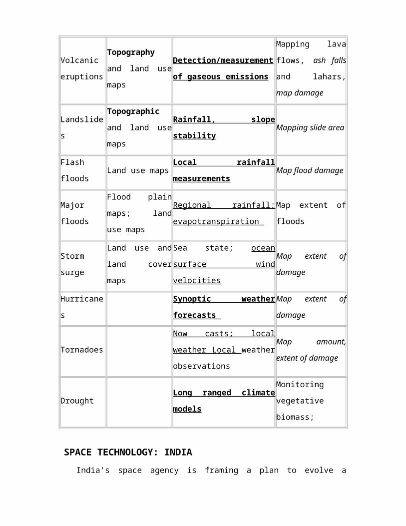
Applications of space remote sensing in disaster management
Disaster Prevention Preparedness (Warning) Relief
Earthquakes Mapping geological
lineaments land use
Geodynamic measurements of
strain accumulation
Locate stricken
areas, map damage
Volcanic
eruptions
Topography and
land use maps
Detection/measurement of
gaseous emissions
Mapping lava flows,
ash falls and lahars,
map damage
Landslides Topographic and
land use mapsRainfall, slope stability Mapping slide area
Flash floods Land use maps Local rainfall measurements Map flood damage
Major floods Flood plain maps;
land use maps
Regional rainfall;
evapotranspiration Map extent of floods
Storm surge Land use and land
cover maps
Sea state; ocean surface wind
velocities
Map extent of
damage
Hurricanes Synoptic weather forecasts Map extent of
damage
Tornadoes Now casts; local weather Local
weather observations
Map amount, extent
of damage
Drought Long ranged climate models Monitoring
vegetative biomass;
SPACE TECHNOLOGY: INDIA India's space agency is framing a plan to evolve a disaster management support system
using the surveillance capabilities of its extensive satellite network. The agency planned
to put to larger use its experience in monitoring and providing cyclone warnings for the
Andhra Pradesh and Orissa coasts. India's space agency is also thinking of evolving a
total disaster management support system by which satellite images will be analyzed and
made available to a disaster management control room. The agency is giving stress on the
use of remote sensing and aerial photography capabilities of Indian satellite to provide
information for relief and rehabilitation.
G. Madhavan Nair, head of the Indian Space Research Organisation (ISRO), said
that the system will be put into operation by the end of the year.
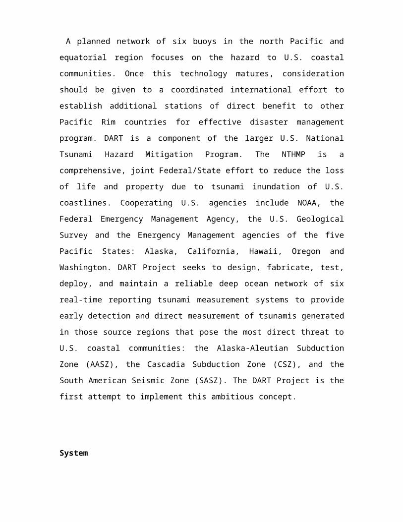
DART PROJECT: - A NOBLE EFFORT
DART Project is an effort by the Pacific Marine Environmental Laboratory of the
National Oceanic and Atmospheric Administration to develop a capability for real-time
reporting of tsunami measurements in the deep ocean. The systems utilize bottom
pressure recorders (BPRs) capable of detecting and measuring tsunamis with amplitude
as small as 1 cm in 6000 m of water. The data are transmitted by acoustic modem to a
surface buoy, which then relays the information to a ground station via satellite
telecommunications.
A planned network of six buoys in the north Pacific and equatorial region focuses on the
hazard to U.S. coastal communities. Once this technology matures, consideration should
be given to a coordinated international effort to establish additional stations of direct
benefit to other Pacific Rim countries for effective disaster management program. DART
is a component of the larger U.S. National Tsunami Hazard Mitigation Program. The
NTHMP is a comprehensive, joint Federal/State effort to reduce the loss of life and
property due to tsunami inundation of U.S. coastlines. Cooperating U.S. agencies include
NOAA, the Federal Emergency Management Agency, the U.S. Geological Survey and
the Emergency Management agencies of the five Pacific States: Alaska, California,
Hawaii, Oregon and Washington. DART Project seeks to design, fabricate, test, deploy,
and maintain a reliable deep ocean network of six real-time reporting tsunami
measurement systems to provide early detection and direct measurement of tsunamis
generated in those source regions that pose the most direct threat to U.S. coastal
communities: the Alaska-Aleutian Subduction Zone (AASZ), the Cascadia Subduction
Zone (CSZ), and the South American Seismic Zone (SASZ). The DART Project is the
first attempt to implement this ambitious concept.
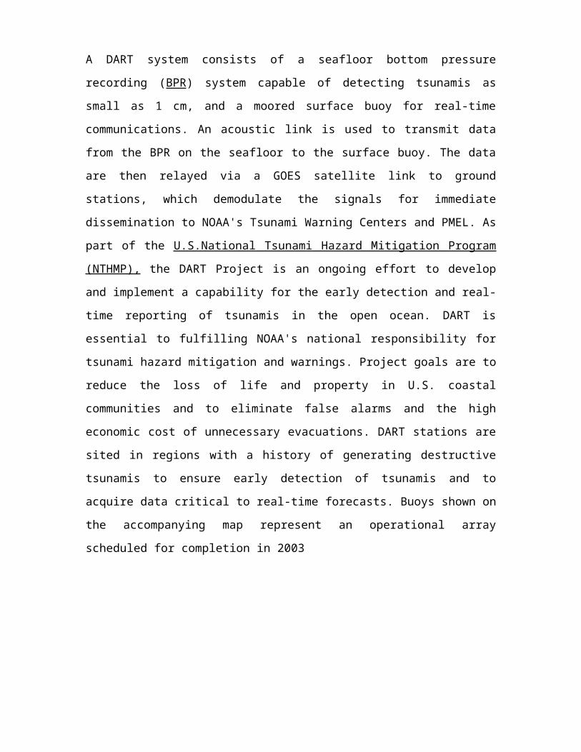
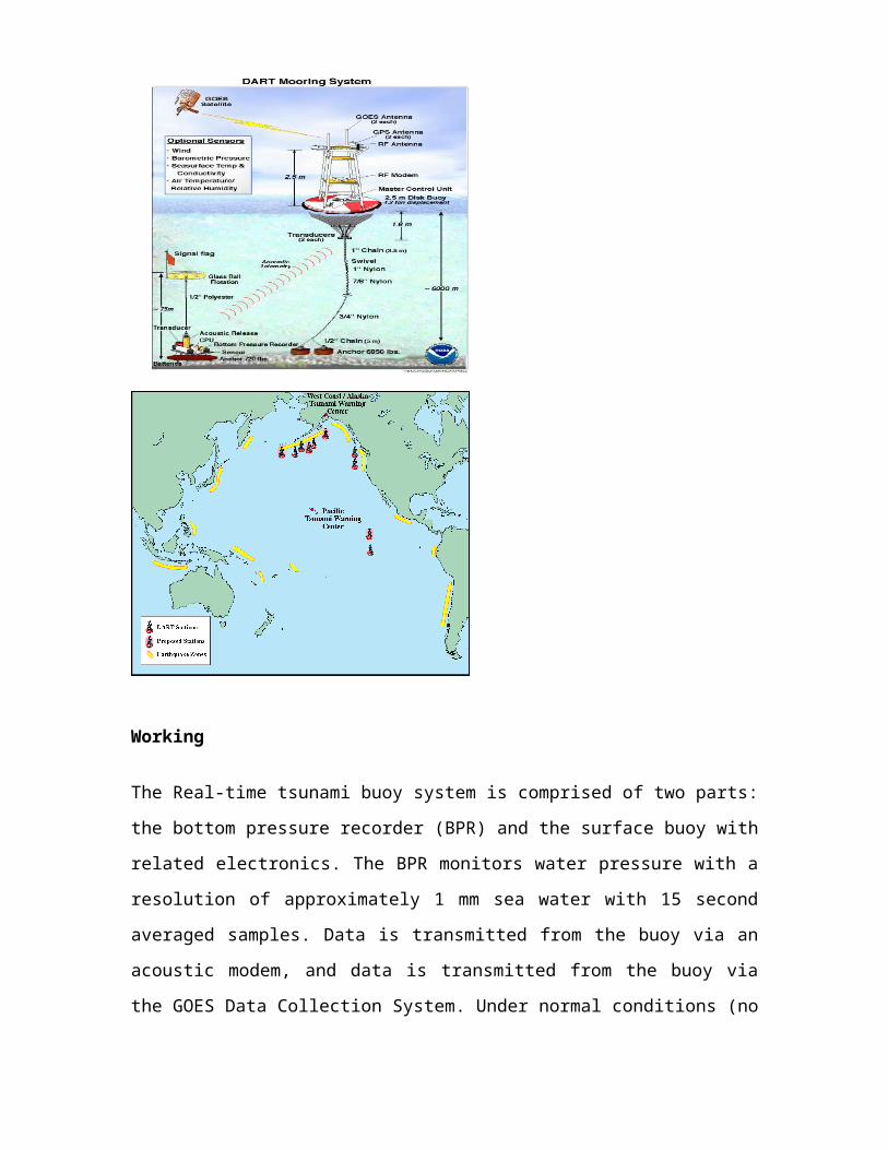
System
A DART system consists of a seafloor bottom pressure recording (BPR) system capable
of detecting tsunamis as small as 1 cm, and a moored surface buoy for real-time
communications. An acoustic link is used to transmit data from the BPR on the seafloor
to the surface buoy. The data are then relayed via a GOES satellite link to ground
stations, which demodulate the signals for immediate dissemination to NOAA's Tsunami
Warning Centers and PMEL. As part of the U.S.National Tsunami Hazard Mitigation
Program (NTHMP), the DART Project is an ongoing effort to develop and implement a
capability for the early detection and real-time reporting of tsunamis in the open ocean.
DART is essential to fulfilling NOAA's national responsibility for tsunami hazard
mitigation and warnings. Project goals are to reduce the loss of life and property in U.S.
coastal communities and to eliminate false alarms and the high economic cost of
unnecessary evacuations. DART stations are sited in regions with a history of generating
destructive tsunamis to ensure early detection of tsunamis and to acquire data critical to
real-time forecasts. Buoys shown on the accompanying map represent an operational
array scheduled for completion in 2003

Working
The Real-time tsunami buoy system is comprised of two parts: the bottom pressure
recorder (BPR) and the surface buoy with related electronics. The BPR monitors water
pressure with a resolution of approximately 1 mm sea water with 15 second averaged
samples. Data is transmitted from the buoy via an acoustic modem, and data is
transmitted from the buoy via the GOES Data Collection System. Under normal
conditions (no tsunami) the BPR sends data hourly that is comprised of four 15-minute
values which are single 15-second averages. The BPR can make up to 3 tries to get
acknowledgment from the surface buoy that the data were received. The data is
reformatted and sent via the GOES self-timed channel and displayed to show Open
Ocean tides. This gives an hourly indication of the health and condition of the entire
system. If data are not received from the bottom, the surface buoy uses the GPS derived
buoy position for the self timed message. An algorithm running in the BPR generates
predicted water height values and compares all new samples with predicted values. If two
15 second water level values exceed the predicted values the system will go into the
Tsunami Response Mode. Data will be transmitted on the Random channel (132) for a
minimum of 3 hours, giving high frequency data on short intervals with 100% repeated
data for redundancy for the first hour. Every GOES transmission will include the time of
T=0, which is the time the second out-of-bound value was detected. Every Tsunami
Response Model message also includes an ID that identifies the type of data and the time
of the data in the message as minutes after T=0. When the time of the hourly self-timed
transmission occurs during a Tsunami Response Mode, the BPR will send one-minute
data, comprised of the average of four 15 second values, for the preceding two hours (120
values). If the ocean is still perturbed after the nominal 3 hours of the Tsunami Response
Mode, the hourly self-timed transmission of 120 one minute averaged values will
continue. The system will return to normal mode only after 3 hours of undisturbed water
heights. This demonstration experiment had the surface unit command the BPR to
transmit data at set intervals. This was considered the most demanding test possible of the
modem capabilities, as the uplink is more robust than the downlink. If the future brings a
two-way satellite link from shore to the buoy it will be desirable to command the system
to send data, which will necessitate a downlink capability. Data from this prototype
system was transmitted via the polar orbiting NOAA TIROS satellite with an Argos
Platform Transmit Terminal. Data was packed into 4 blocks of 32 bytes each and
transmitted on a 90-second round robin schedule in a 4-hour window when a satellite was
in view. This method is not acceptable for a real-time reporting system due to the
inherent delay, but served as an expedient test platform. An operational mooring would
send data via the NOAA GOES geostationary satellite or through one of the commercial
low earth orbit satellites soon to be available.
Photographs of Prototype DART system at Pacific Ocean

Results of Field Experiment
The prototype mooring was deployed at 46 28 N, 129 30 W in 2611 m of water on 23
May and recovered on 19 July 1995. The BPR was moored approximately 250 m from
the anchor of the surface mooring. The BPR, acoustic modems, software protocols, and
satellite data telemetry performed as expected throughout the 57-day period. Pressure
data transmitted in engineering units were received daily and showed the dominant tidal
cycles and the characteristic low drift of the Paros sensor.
The mooring was located within 70 km of a NOAA NDBC buoy, which reported winds
and wave data. Although summer weather prevailed in the latter half of the deployment,
significant wave heights exceeded 6 m on 11 June and winds of 10 m/sec or greater were
common in June. There was no loss of data correlated with periods of high wind and
waves. This indicated that surface wave noise and wave-driven buoy motion was not a
factor in the acoustic modem performance. However, approximately 5% of the data were
lost in the transmission cycle. On three occasions, engineering records indicate that the
subsurface unit did not respond to commands from the surface unit. On nearly all other
occasions the subsurface unit responded on the first request and the uplink worked
without fail. The 60 beam pattern of the transducers, unknown BPR platform attitude, and
the 1.4 km buoy watch circle may have contributed to the lost transmissions.
Although very successful, this experiment showed the necessity of quantifying the
operating parameters of the modems and increasing the engineering data stored and
transmitted. Wider beam transducers, possibly with higher power, will be evaluated.
Gimbaling the subsurface transducer mounts or additional baffling of the surface
transducer may improve the signal-to-noise ratio. Also, engineering efforts will be
directed at refining modem protocols and evaluating satellite telemetry options. To
complement any two-way telemetry scheme, algorithms will be developed for the BPR
firmware that will detect a passing tsunami and initiate data transmission from the bottom
unit. This scheme will be inherently more robust and, with hourly reporting of
operational status, reliability of the mooring system could be assured.
All Tsunami data use a simple data compression scheme. The first data value is the full
water column height in mm of sea water. The following values are signed, 16 bit numbers
representing departures from the full values in mm of sea water.
Proposed Pacific Array
Detection systems strategically located seaward of known tsunami source regions
will provide the needed verification within minutes of an earthquake through direct
measurements. If no tsunami is detected, a false alarm will be averted. Conversely, if a
tsunami is detected, the detection system will provide warning centers with the single
most important piece of information required for decision-making: the deep ocean
tsunami amplitude. Consequently, this system will not only decrease false alarms, but
will also improve the speed and accuracy of true alarms.
Conclusion
It is almost impossible to avoid or to resist the natural hazards completely, but the
effect of such hazards can be minimized using modern technologies. One of the modern
technologies i.e. Space Technology plays very important role in Disaster Management
and Mitigation. It consists of use of various satellites like Earth observation satellites,
Polar orbiting satellites, Geo-stationary satellites etc.
Earth observation satellites contribute to providing solutions in all phases of
disaster management. An important aspect is risk assessment of disaster-prone areas via
satellite remote sensing. Remote sensing can also provide information needed to assess
the extent of damage caused by a disaster and forecast the expected further spread of the
disaster to other areas, as well as vital information to search and rescue operations.
Satellite technology can re-establish communications in the afflicted area when the on-
ground infrastructure has broken down.
Due to its advantage position Space Technology becomes important in Disaster
Management and Mitigation. A deep ocean, early detection and real-time reporting
tsunami monitoring network is planned. Six stations, sited near potential generation
zones, are established in the year 2000. In the last year, two DART systems have been
designed, fabricated, tested, and deployed in the North Pacific. Physical survivability and
reliable data return are the primary technological challenges. The systems have survived
well, and successfully transmitted real-time data in seas with significant wave heights
that exceed 10 m. Each deployed system has provided extended periods of excellent data
return, thus proving the feasibility of the concept. This U.S. research and development
effort is focused on the hazard to U.S. coastal communities. However, the planned station
between Hawaii and tsunami sources off South America will also benefit countries in the
western Pacific that are threatened by such tsunamis. Once this technology matures,
consideration should be given to a coordinated international effort to establish additional
stations. For example, additional South American stations and many asian stations would
improve coverage of that source region, and stations off Kamchatka and in the eastern
Sea of Japan would benefit Japan, Korea and Russia.
References
1. Bernard, E.N. (1997): Reducing tsunami hazards along U.S. coastlines. In
Perspectives on Tsunami Hazard Reduction, Proceedings of the 1995 IUGG
Tsunami Symposium, Kluwer Academic Publishers, 189-203.
2. Black, P.G., J.R. Proni, J.C. Wilkerson, C.E. Samsbury (1997): Oceanic Rainfall
Detection and Classification in Tropical and Subtropical Mesoscale Convective
Systems Using Underwater Acoustic Methods, Monthly Weather Review, 125,
2014-2042.
3. Hagemeyer, R., 1998: Tsunami hazard mitigation in U.S., these Proceedings.
4. Milburn, H.B., A.I. Nakamura, and F.I. González (1996): Real-time tsunami
reporting from the deep ocean. In Proceedings of the Oceans 96 MTS/IEEE
Conference, 23-26 September 1996, Fort Lauderdale, FL, 390-394.
5. Scussel, K.F., J.A. Rice and S. Merriam (1997): A New MFSK Acoustic Modem
for Operation in Adverse Underwater Channels. In Proceedings of the OCEANS
96 MTS/IEEE Conference, 6-9 October 1997, Halifax, Nova Scotia.