Embed Size (px)
Citation preview

Metrology for long distance surveying
ABSTRACT BOOK
PORTUGUESE INSTITUTE FOR QUALITY
21st November 2014
Auditório, IPQ, Caparica
PORTUGAL
www.ipq.pt
Metrology for Long Distance Surveying
IPQ, Caparica | Portugal | 21st November 2014
INTRODUCTION
The accurate measurement of distances of up to kilometres is the basis of modern surveying
and geodesy. A number of most critical tasks, however, like
• sensitive surveillance networks at critical sites
• local ties at geodetic fundamental stations
• high-precision sub-surface surveying work
require measurement uncertainties of typically 1 mm or better for distances of more than
several hundred meters in uncontrolled environments – unachievable with current state of the
art instrumentation, neither with optical nor with GNSS-based distance metrology.
To respond to this need for improvement in measurement technology, EURAMET and the EU
funded the joint research project (JRP) SIB60 “Metrology for long distance surveying” within
the European Metrology Research Programme (EMRP). This project started in July 2013 and
unites metrologists, surveyors and geodesists from 15 European research institutions.
The JRP-Consortium would like to invite interested parties from surveying, geodesy, science
and application to discuss the first results of this project and to share conclusions.

Metrology for Long Distance Surveying
IPQ, Caparica | Portugal | 21st November 2014
IPQ Local Organization
Fernanda Saraiva, ULNM
Fátima Marques, ULNM
Isabel Silva, DAESPQ
Amélia Dias, DAESPQ
Carlos Pires, ULNM
Sara Neves, DAESPQ
Olivier Pellegrino, ULNM
Isabel Godinho, ULNM
Armando Ferreira, DAG
Liliana Eusébio, ULNM
Scientific Committee
StenBergstrand, SP
Steven van den Berg, VSL
Olivier Pellegrino, IPQ
Florian Pollinger, PTB
Markku Poutanen, FGI
Fernanda Saraiva, IPQ
Jean-Pierre Wallerand, LNE-CNAM
Metrology for Long Distance Surveying
IPQ, Caparica | Portugal | 21st November 2014
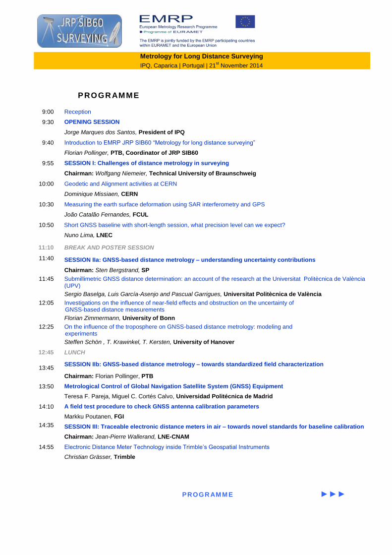
PROGRAMME
9:00 Reception
9:30 OPENING SESSION
Jorge Marques dos Santos, President of IPQ
9:40 Introduction to EMRP JRP SIB60 “Metrology for long distance surveying”
Florian Pollinger, PTB, Coordinator of JRP SIB60
9:55 SESSION I: Challenges of distance metrology in surveying
Chairman: Wolfgang Niemeier, Technical University of Braunschweig
10:00 Geodetic and Alignment activities at CERN
Dominique Missiaen, CERN
10:30 Measuring the earth surface deformation using SAR interferometry and GPS
João Catalão Fernandes, FCUL
10:50 Short GNSS baseline with short-length session, what precision level can we expect?
Nuno Lima, LNEC
11:10 BREAK AND POSTER SESSION
11:40 SESSION IIa: GNSS-based distance metrology – understanding uncertainty contributions
Chairman: Sten Bergstrand, SP
11:45 Submillimetric GNSS distance determination: an account of the research at the Universitat Politècnica de València (UPV)
Sergio Baselga, Luis García-Asenjo and Pascual Garrigues, Universitat Politècnica de València
12:05 Investigations on the influence of near-field effects and obstruction on the uncertainty of GNSS-based distance measurements
Florian Zimmermann, University of Bonn
12:25 On the influence of the troposphere on GNSS-based distance metrology: modeling and experiments
Steffen Schön , T. Krawinkel, T. Kersten, University of Hanover
12:45 LUNCH
13:45
SESSION IIb: GNSS-based distance metrology – towards standardized field characterization
Chairman: Florian Pollinger, PTB
13:50 Metrological Control of Global Navigation Satellite System (GNSS) Equipment
Teresa F. Pareja, Miguel C. Cortés Calvo, Universidad Politécnica de Madrid
14:10 A field test procedure to check GNSS antenna calibration parameters
Markku Poutanen, FGI
14:35 SESSION III: Traceable electronic distance meters in air – towards novel standards for baseline calibration
Chairman: Jean-Pierre Wallerand, LNE-CNAM
14:55 Electronic Distance Meter Technology inside Trimble’s Geospatial Instruments
Christian Grässer, Trimble
PROGR AM M E ►►►
Metrology for long distance surveying | IPQ, Caparica | 9:00 | 21
st November 2014
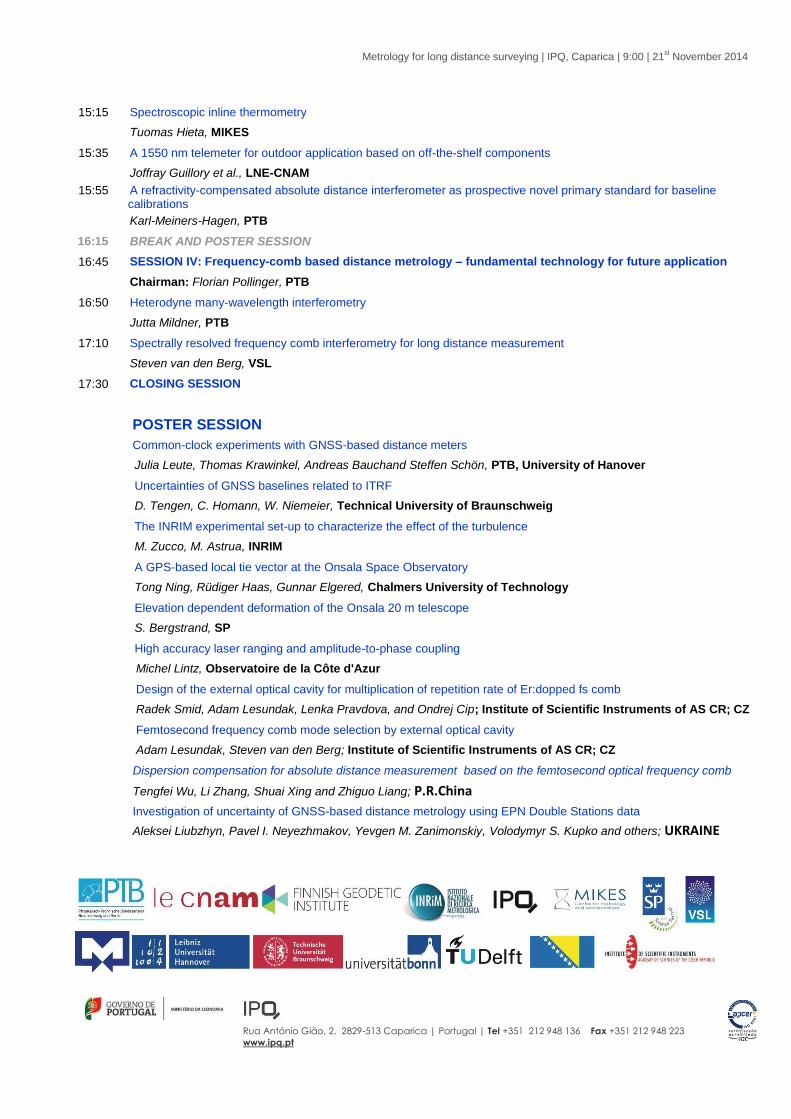
15:15 Spectroscopic inline thermometry
Tuomas Hieta, MIKES
15:35 A 1550 nm telemeter for outdoor application based on off-the-shelf components
Joffray Guillory et al., LNE-CNAM
15:55 A refractivity-compensated absolute distance interferometer as prospective novel primary standard for baseline calibrations
Karl-Meiners-Hagen, PTB
16:15 BREAK AND POSTER SESSION
16:45 SESSION IV: Frequency-comb based distance metrology – fundamental technology for future application
Chairman: Florian Pollinger, PTB
16:50 Heterodyne many-wavelength interferometry
Jutta Mildner, PTB
17:10 Spectrally resolved frequency comb interferometry for long distance measurement
Steven van den Berg, VSL
17:30 CLOSING SESSION
POSTER SESSION
Common-clock experiments with GNSS-based distance meters
Julia Leute, Thomas Krawinkel, Andreas Bauchand Steffen Schön, PTB, University of Hanover
Uncertainties of GNSS baselines related to ITRF
D. Tengen, C. Homann, W. Niemeier, Technical University of Braunschweig
The INRIM experimental set-up to characterize the effect of the turbulence
M. Zucco, M. Astrua, INRIM
A GPS-based local tie vector at the Onsala Space Observatory
Tong Ning, Rüdiger Haas, Gunnar Elgered, Chalmers University of Technology
Elevation dependent deformation of the Onsala 20 m telescope
S. Bergstrand, SP
High accuracy laser ranging and amplitude-to-phase coupling
Michel Lintz, Observatoire de la Côte d'Azur
Design of the external optical cavity for multiplication of repetition rate of Er:dopped fs comb
Radek Smid, Adam Lesundak, Lenka Pravdova, and Ondrej Cip; Institute of Scientific Instruments of AS CR; CZ
Femtosecond frequency comb mode selection by external optical cavity
Adam Lesundak, Steven van den Berg; Institute of Scientific Instruments of AS CR; CZ
Dispersion compensation for absolute distance measurement based on the femtosecond optical frequency comb
Tengfei Wu, Li Zhang, Shuai Xing and Zhiguo Liang; P.R.China
Investigation of uncertainty of GNSS-based distance metrology using EPN Double Stations data
Aleksei Liubzhyn, Pavel I. Neyezhmakov, Yevgen M. Zanimonskiy, Volodymyr S. Kupko and others; UKRAINE
Rua António Gião, 2, 2829-513 Caparica | Portugal | Tel +351 212 948 136 Fax +351 212 948 223
www.ipq.pt

Metrology for Long Distance Surveying
IPQ, Caparica | Portugal | 21st November 2014
ABSTRACTS
Metrology for Long Distance Surveying
IPQ, Caparica | Portugal | 21st November 2014
OPENING SESSION
Introduction to EMRP JRP SIB60
“Metrology for long distance surveying”
1st
Workshop on Metrology for Long Distance Surveying Caparica, Portugal, 21
st November 2014
Introduction to EMRP JRP SIB60 “Metrology for long distance surveying”
F. Pollinger1,*
, M. Astrua2, A. Bauch
1, S. Bergstrand
3, N. Bhattacharya
4, A. Bosnjakovic
5, L. Eusebio
6,
E. Filipe6, C. Francese
2, B. Görres
7, J. Guillory
8, T. Hieta
9, C. Homann
10, J. Jokela
11, U. Kallio
11,
T. Kersten12
, H. Koivula11
, T. Krawinkel12
, H. Kuhlmann7, V. Kupko
13, A. Lesundak
14, J. Leute
1,
F. Marques6, K. Meiners-Hagen
1, M. Merimaa
9, J. Mildner
1, W. Niemeier
10, P. Neyezhmakov
13,
O. Pellegrino6, C. Pires
6, M. Poutanen
11, F. Saraiva
6, S. Schön
12, D. Tengen
10, S. A. van den Berg
15,
J.-P. Wallerand8, F. Zimmermann
7, M. Zucco
2
1 Physikalisch-Technische Bundesanstalt (PTB), Bundesallee 100, 38116 Braunschweig, Germany
2 Instituto Nazionale di Ricercia Metrologica (INRIM), Strada delle Cacce 91, 10135 Torino, Italy
3 SP Technical Research Institute of Sweden, P. O. Box 857, 50115 Borås, Sweden
4 Optics Research Group, Faculty of Applied Sciences, Delft University of Technology, Lorentzweg 1, 2628 CJ Delft,
Netherlands
5 Institut za mjeriteljstvo Bosne i Hercegovine (IMBiH), Augusta Brauna 2, BA-71000 Sarajevo, Bosnia and Herzegovina
6 Instituto Português da Qualidade (IPQ), Rua António Gião 2, 2829-513 Caparica, Portugal
7 University of Bonn, Institute of Geodesy and Geoinformation, Nußallee 17, 53115 Bonn, Germany
8 Conservatoire National des Arts et Métiers (CNAM), 292 rue Saint-Martin, 75141 Paris Cédex 03,, France
9 Centre for Metrology and Accreditation (MIKES), Tekniikantie 1, 02151 Espoo, Finland
10 Technische Universität Braunschweig, Institut für Geodäsie und Photogrammetrie, Pockelstraße 3, 38106 Braunschweig,
Germany
11 Finnish Geodetic Institute, PL 15, Geodeetinrinne 2, 02431 Masala, Finland
12 Leibniz Universität Hannover, Institute für Erdmessung, Schneiderberg 50, 30167 Hannover, Germany
13 National Scientific Centre “Institute of Metrology” (NSC-IM), 42 Mironositskaya Street, 61002 Kharkov, Ukraine
14 Institute of Scientific Instruments, Academy of Sciences of the Czech Republic, Krávopolská, 612 64 Brno, Czech Republic
15 National Metrology Institute VSL, Thijsseweg 11, 2629 JA Delft, The Netherlands
* Corresponding author: [email protected]
Keywords: traceability, EDM, GNSS-based distance meters, local tie metrology, EMRP
Abstract
In December 2012, the European Metrology Research Programme (EMRP) [1] decided to
fund the three-year international joint research project (JRP) SIB60 “Metrology for long
distance surveying” [2] in the framework of its “SI Broader Scope II” targeted program. The
project unites metrologists, surveyors and geodesists in a major effort to develop novel
technologies and methods to improve traceability and to reduce uncertainties of length
metrological tools used in surveying, both of optics-based (electro-optic distance meters
(EDM)), and of GNSS-based technologies.
The major scientific and technical objectives of the project are :
(1) To focus on the optical measurement in air, in particular on the inline compensation
of the refractive index along the whole beam path, but also on the impact of
turbulences on the measurement, targeting a relative uncertainty of 10-7
over a
distance of 1 km.
„
1st
Workshop on Metrology for Long Distance Surveying Caparica, Portugal, 21
st November 2014
(2) To gain a better understanding of the uncertainty of GNSS-based distance metrology.
The studies will allow the development of a sound uncertainty model and an
optimized field calibration procedure, targeting absolute uncertainties of 1 mm and
better.
(3) To explore different concepts for the application of femtosecond laser-based
many-wavelength interferometry to long-distance metrology with a targeted relative
measurement uncertainty significantly better than 4x10⁻⁷
under controlled
environment indoor and well-monitored conditions outdoor.
(4) To develop solutions to improve state-of-the-art surveying practice immediately,
ranging from field-capable optical standards with relative uncertainties of 10-7
for
long-distance baseline calibrations, over refined guidelines for the calibration of both
EDM and GNSS-based distance meters, up to an extensive inter-comparison of major
primary geodetic baselines in Europe.
(5) To investigate different approaches to real-time monitoring of local ties at geodetic
fundamental stations, both experimentally and theoretically. Thus, fundamental
metrology for the Global Geodetic Observing System (GGOS) is developed adhering
the overall target to reduce uncertainty of reference frames to 0.1 mm.” [2]
In the first 14 months of the project duration, major challenges have been tackled. Concepts
of novel primary optical refractivity-compensated standards have been realized. Field-
capable prototypes are currently being characterized, improved and verified. Complex
uncertainty contributions to GNSS-based distance measurements, like influence of
troposphere and near-field are being experimentally studied, and a field-procedure for the
verification of electromagnetic antenna calibration parameters was developed and is being
tested. In addition, larger space-geodetic campaigns are prepared to investigate different 3D
real time concepts for local tie metrology at geodetic fundamental stations.
This presentation is intended to introduce the project as a whole to the participants of this
first public Workshop and give a broader survey of first achievements. It should set a
common basis for fruitful discussions on technical details, but also on the broader picture
during the day, and beyond.
The presented joint research project SIB60 “Surveying” receives funding by the European
Metrology Research Programme (EMRP). The EMRP is jointly funded by the EMRP
participating countries within EURAMET and the European Union
[1] www.emrponline.eu
[2] JRP SIB60 Surveying, Publishable JRP Summary Report for JRP SIB60 Surveying, www.
emrp-surveying.eu, (2014)
Metrology for Long Distance Surveying
IPQ, Caparica | Portugal | 21st November 2014
SESSION I
Challenges of distance metrology
in surveying
1st
Workshop on Metrology for Long Distance Surveying Caparica, Portugal, 21
st November 2014
Survey activities at CERN
Dominique Missiaen1,*
1 CERN, 1211 Geneva 23, Switzerland
Keywords : CERN, survey, alignment, metrology
Abstract
CERN, the European Laboratory for Particle Physics, is the first laboratory in the world for
fundamental research and especially at High Energy. Its flagship, the Large Hadron Collider
(LHC), a circular proton-proton collider of 27 km of circumference, has permitted the
discovery of the Higgs’s particle in 2012 inside its two large experimental detectors ATLAS
and CMS.
All along the 27 km vacuum chamber, many accelerator components are interacting with the
particle beam: quadrupole magnets are either focusing or defocusing the beam, dipole
magnets are bending it to give its circular shape, accelerator cavities produce a higher speed
and many other secondary equipment provide with information on the beam characteristics.
All these components have to be aligned with an accuracy never reached before, typically a
couple of mm as an absolute accuracy and 0.1-0.2 mm as a relative one.
The talk will present the specific techniques which are used at CERN to achieve the
requested accuracy and the geodetic needs for the future big projects in the domain of
particle physics.
1st
Workshop on Metrology for Long Distance Surveying Caparica, Portugal, 21
st November 2014
Measuring the earth’s surface deformation using InSAR and GPS
João Catalão
Instituto D. Luiz, Faculdade de Ciencias da Universidade de Lisboa
Campo Grande, 1749-016 Lisboa, Portugal
* Corresponding author: [email protected]
Keywords : Deformation, GPS, SAR interferometry
Abstract
Space-borne global positioning systems brought new insights to the geodetic science
providing means to measure the position, and their time variation, of points on the earth’s
surface, with unprecedented accuracy. Among others, the Global Position System (GPS)
offers an accuracy and spatial coverage that was not available using classical methodologies.
Despite its high accuracy, GPS-based systems are point-like measurements with a scarce
distribution on the earth’s surface that can be complemented with synthetic aperture radar
interferometric (InSAR) measurements. In fact, these imaging system provides measurements
of deformation in the satellite line of sight of vast areas of the earth surface with a time
resolution of about 6 days (at the equator). The repeat-pass space-borne SAR interferometric
approach is based on the phase comparison of two synthetic aperture radar (SAR) images
acquired at different times with slightly different looking angles. The acquisition of SAR
images was initiated regularly by ESA in 1992 with the launch of the ERS1 satellite and was
followed by ERS2, ENVISAT and the Setinel-1A (2014) missions. In this communication we
will present a method to derive accurate spatially dense maps of 3-D terrain displacement
velocity based on the merging of terrain displacement velocities estimated by time series of
interferometric synthetic aperture radar data acquired along ascending and descending orbits
and repeated GPS measurements. The method uses selected persistent scatterers (PSs) and
GPS measurements of the horizontal velocity. It is shown that accurate vertical velocities at
PS locations can be retrieved if smooth horizontal velocity variations can be assumed. The
proposed methodology is applied to the case study of Azores islands and Singapore
characterized by important tectonic and subsidence phenomena, respectively.
Acknowledgments
This is a contribution to Project MEGAHazards (PTDC/CTE-GIX/108149/2008) funded by
FCT, Portugal.
1st
Workshop on Metrology for Long Distance Surveying Caparica, Portugal, 21
st November 2014
Short GNSS baseline with short-length session, what precision level can we
expect?
José Nuno Lima1,*
1 Laboratório Nacional de Engenharia Civil, Avenida do Brasil, 101 -1700-066 Lisboa, Portugal
* Corresponding author: [email protected]
Keywords : GNSS, short-length session, short baseline, precision
Abstract
To test the viability of the GNSS with short-length sessions in the measuring of
displacements at large dams, the Division of the Applied Geodesy of the Concrete Dams
Department, of the National Civil Engineering Laboratory (LNEC), has carried out several
studies on a 325 m baseline, with different length observation sessions.
Precise GNSS relative positioning requires the using of carrier-phase observations, at the least
of two receivers, and fixing the integer ambiguities. With increasing distance between
receivers, ambiguity fixing becomes more difficult because ionospheric and tropospheric
effects do not cancel sufficiently in double difference. A most common procedure in static
relative positioning is to increase the length of the observation session and/or to apply
atmospheric models and corrections. In general, increasing the length of the observation
session promotes the decrease of the uncertainty of the displacements measured by the GNSS.
In fact, we have carried out several tests in LNEC campus, on a 325 meters length GNSS
baseline, with different length sessions, from 1 minute to 24 hours, which are proving this
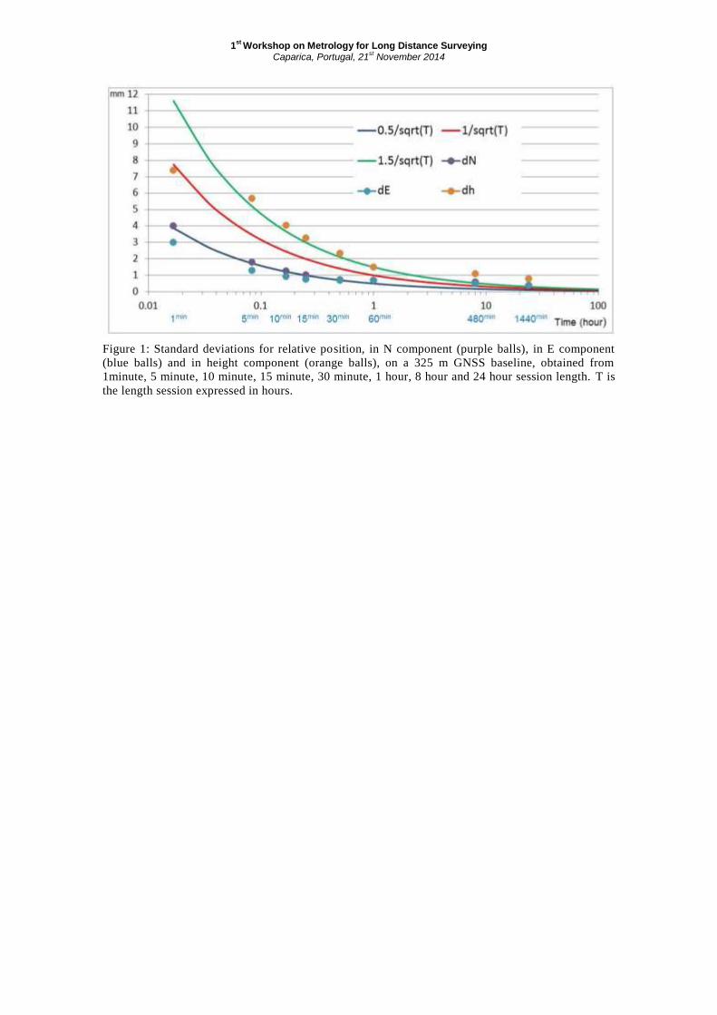
statement. Figure 1 present the results obtained: the standard deviations for the relative
position, in North component (purple balls), East component (blue balls) and height
component (orange balls) decrease with the increasing of the session length.
As shown in Figure 1, the standard deviation for relative positioning in N component is
similar for the E component, but for the height component it is 3 times higher. For example,
we obtained for length sessions of 5 minutes the value 1.8 mm for standard deviation in
horizontal component and the value 5.7 mm for standard deviation in vertical component.
1st
Workshop on Metrology for Long Distance Surveying Caparica, Portugal, 21
st November 2014
Figure 1: Standard deviations for relative position, in N component (purple balls), in E component
(blue balls) and in height component (orange balls), on a 325 m GNSS baseline, obtained from
1minute, 5 minute, 10 minute, 15 minute, 30 minute, 1 hour, 8 hour and 24 hour session length. T is
the length session expressed in hours.
Metrology for Long Distance Surveying
IPQ, Caparica | Portugal | 21st November 2014
SESSION IIa
GNSS-based distance metrology –
understanding uncertainty
contributions
1st
Workshop on Metrology for Long Distance Surveying Caparica, Portugal, 21
st November 2014
Submillimetric GNSS distance determination: an account of the research at
the Universitat Politècnica de València (UPV)
Sergio Baselga1,*
, Luis García-Asenjo1 and Pascual Garrigues
1
1 Cartographic Engineering, Geodesy and Photogrammetry Department, Universitat Politècnica de València, Valencia,
Camino de Vera s/n, Spain
* Corresponding author: [email protected]
Keywords : Distance measurement, GNSS, calibration baseline.
Abstract
In this contribution we present our approach to investigate the capabilities of GNSS for
determining distances up to 1 km with submillimetric accuracy. Among the initial
assumptions that may lead to consider GNSS as a potential submillimetric measuring tool we
find its high stability at the global scale (1 ppb) and the low noise (at the submillimeter level)
that may attain some modern receivers in their phase observations.
Our approach is specifically tailored to the problem of determining only the slant distance that
substantially differs from the traditional geodetic approach where ambiguities are usually
determined and the baseline spatial orientation is also required. We only use L1 phase
observations along with an ambiguity free model that only requires the knowledge of the
approximate coordinates of the baseline ends within a few centimeters, which is easily
achievable e.g. by means of an initial PPP processing.
Some preliminary results were obtained after an automated processing of different baselines
in 1h timespans along entire years, which resulted in nearly 9000 values for each baseline and
year. We identified the multipath effect of one sidereal day period as the major source of
GNSS length variation. We also experienced that antenna calibration accuracies play a non-
negligible role in this question, fact that was already concluded in previous studies. We found
variations to be considerably mitigated after a 24 h observation time and corresponding results
to be consistent in the long term below the millimeter level although some unmodelled effects
of the order of a few tenths of a millimeter still remained. In addition, we also found that
robust estimation computed as a global optimization problem permits further reduction of
those variations.
Once the inner consistency of GNSS lengths has been found to be stable at the few
submillimeter level in the mid and long term (days to months) there remains the question of
comparison with the absolute SI meter. This comparison should be conducted in outdoor
facilities that have been proved stable to the submillimeter level and whose distances have
been traced to the SI meter. Few test fields meet such demanding requirements, e.g. Nummela
Standard Baseline. Therefore we decided to transfer absolute scale from Nummela to our test
field in the UPV in 2012 and carry out periodical deformation monitoring in cooperation with
the Universidad Complutense de Madrid (UCM) using a Mekometer ME5000. Ongoing
GNSS campaigns in our facility are now being conducted in order to assure that GNSS
lengths are not only self-consistent and stable in the long term below the millimeter level but
also accurately related to the absolute meter.
1st
Workshop on Metrology for Long Distance Surveying Caparica, Portugal, 21
st November 2014
Investigations on the influence of near-field effects and obstruction on the
uncertainty of GNSS-based distance measurements
Florian Zimmermann1,*
, Heiner Kuhlmann1
1 University of Bonn, Institute of Geodesy and Geoinformation, Nussallee 17, 53115 Bonn, GERMANY
Keywords: antenna near-field effects, antenna spacer, satellite shadowing scenarios
Abstract
These investigations are performed within the joint research project SIB60 “Surveying” of
the European Metrology Research Programme (EMRP). The EMRP is jointly funded by the
EMRP participating countries within EURAMET and the European Union.
Antenna near-field effects are one of the accuracy limiting factors on GNSS-based distance
measurements. In order to analyse these influences, a measurement campaign at an EDM
calibration baseline site near Munich was performed. During the campaign, 6 pillars of the
baseline site with distances between 19 and 1100 meters were equipped with different kinds
of antenna mounts. In particular, spacer types of different length and material were used to
increase the distance between the pillar and the antenna and thus, to analyse the possibility to
separate or minimize the impact of antenna near-field effects from the coordinate
determination process. Prior to the measurement campaign, the PCOs and PCVs of the
GNSS-antennas were calibrated in an anechoic chamber at the University of Bonn. The
intention of these investigations is to identify an optimum configuration for the antenna set-
up by comparison of the GNSS-based distance measurements from 90 baselines with diverse
combinations of antenna mounts to known reference values of height and distance.
The analysis of the computed differences reveals that the most critical step during the
measurement process is the precise levelling and centering of the antenna set-up on the
reference point of each pillar. Uncertainties ascribed to the centering of the antennas can lead
to maximal deviations of up to 3 millimetres in the distance component and thus, lead to a
high variance of the differences and a deterioration of the uncertainty level. It becomes
obvious that the precise centering and levelling of the antennas is a non trivial process,
independent from the spacer length.
First results show that using different spacer type materials, i.e., aluminium and carbon fibre
does not significantly improve the distance measurements and thus, can be excluded as an
option to optimize the antenna set-up. Furthermore, also no differences between the different
spacer lengths can be identified yet.
In addition to antenna near-field effects, satellite obstructions are a further problem in high
precision GNSS-based length measurements, since it is usually not possible to work in an
optimum surrounding, i.e., nearly free of multipath and free horizon. Several shadowing
scenarios will be presented, which will be used to analyse and quantify the influence of
satellite shadowing by numerical simulations on observations by otherwise perfectly
calibrated antenna set-ups.
1st Workshop on Metrology for Long Distance Surveying
Caparica, Portugal, 21st November 2014
On the influence of the troposphere on GNSS based distance metrology:
modeling and experiments
Thomas Krawinkel, Tobias Kersten* and Steffen Schön Leibniz Universität Hannover, Institut für Erdmessung, Schneiderberg 50, 30167 Hannover, Germany
* Corresponding author: [email protected]
Keywords: GNSS, troposphere, local ties
Abstract
Apparent coordinate changes in GNSS time series represent a significant issue in GNSS reference station networks. Especially co-located stations and other GNSS reference stations are influenced by the type of GNSS processing. By varying observables or hardware equipment (antenna changes) apparent coordinate changes mainly in the up-component can be expected although an individually and absolute calibrated GNSS antenna remains in the same geometrical place. In this contribution the authors propose a classification to understand and to model these variations. Therefore the systematic effects on the GNSS observables are categorised into (1) a mathematical and (2) a physical effect. This classification allows analysing the individual contributions of the different impacts on the apparent coordinate changes. A comprehensive data analysis with 9 different reference station antennas is presented. It will be shown that L1 and L2 time series show high consistent repeatability of less than 1mm variations for identical antenna types. In the case of additionally estimated troposphere parameters it will be shown that a direct link between troposphere parameters and station height with a relation of 1:-3 can be expected. It is verified that 1mm tropospheric correction leads to -3mm in the up-component regardless of the used antenna equipment. Gained insights will be discussed in the context of coordinate discrepancies in the local ties of ITRF (International Terrestrial Reference Frame) and recommendations will be given to significantly reduce this issue in GNSS processing. They can be summarized as follows: In small scaled networks with similar tropospheric conditions it is advisable to reduce the apparent offsets by using double differences. If this should not be possible and additionally troposphere parameters have to be estimated, this presentation shows how to significantly reduce the mathematical effect on the station height by applying an additional correction. This contribution is embedded in the joint research project SIB60 “Surveying”, funded by the European Metrology Research Programme (EMRP) participating countries within EURAMET and the European Union.
Metrology for Long Distance Surveying
IPQ, Caparica | Portugal | 21st November 2014
SESSION IIb
GNSS-based distance metrology –
towards standardized field
characterization
1st
Workshop on Metrology for Long Distance Surveying Caparica, Portugal, 21
st November 2014
Metrological Control of Global Navigation Satellite System (GNSS)
Equipment
Teresa F. Pareja1,*
, Miguel C. Cortés Calvo2
1 Laboratorio de control metrológico de instrumental geodésico y topográfico. Universidad Politécnica de Madrid. Campus
Sur. Carretera de Valencia km 7; 28031 Madrid, Spain
2 Laboratorio de control metrológico de instrumental geodésico y topográfico. Universidad Politécnica de Madrid.
Keywords : GNSS, networks control, traceability, uncertainty
Abstract
The studies carried out so far for the determination of the quality of measurement of geodetic
instruments have been aimed, primarily, to measure angles and distances. However, in recent
years it has been accepted to use GNSS (Global Navigation Satellite System) equipment in
the field of Geomatic applications, for data capture, without establishing a methodology that
allows obtaining the calibration correction and its uncertainty.
The purpose of this contribution is to establish the requirements that a network must meet to
be considered a Standard Network with metrological traceability, as well as the methodology
for the verification and calibration of GNSS instrumental in those standard networks. To do
this, a technical calibration procedure, based on ISO17123-8:2007, has been designed,
developed and defined for GNSS equipment determining the contributions to the uncertainty
of measurement. The procedure, which has been applied in different networks for different
equipment, has allowed determining the expanded uncertainty of such equipment following
the recommendations of the Guide to the Expression of Uncertainty in Measurement of the
Joint Committee for Guides in Metrology (JCGM).
Based on high technical quality studies and observations carried out in these networks
previously, it has been possible the estimation of local calibration corrections for high
accuracy GNSS equipment in standard networks. In addition, the uncertainty of calibration
correction has been calculated using two different methodologies: the first one by applying
the law of propagation of uncertainty, while the second has applied the propagation of
distributions using the Monte Carlo method. The analysis of the obtained results confirms the
validity of both methodologies for estimating the calibration uncertainty of GNSS equipment.
1st
Workshop on Metrology for Long Distance Surveying Caparica, Portugal, 21
st November 2014
A field test procedure to check GNSS antenna calibration parameters
Ulla Kallio*, Hannu Koivula, Sonja Nyberg, Markku Poutanen and Jorma Jokela
Finnish Geodetic Institute, Geodeetinrinne 2, 02430 Masala, Finland
* Corresponding author: [email protected]
Keywords : GNSS antenna, calibration, test field
Abstract
The Global Positioning System (GPS) and other satellite navigation systems, altogether
called Global Navigation Satellite Systems (GNSS), offer tools to measure distances with
millimetre accuracy and with no need of visibility between the receivers. In the viewpoint of
metrology the traceability of measurements is uncontrollable because the distance obtained
with the GNSS measurement cannot be unambiguously conducted from the definition of
metre. Within the SIB60 project the Finnish Geodetic Institute has built a GNSS test field at
the Metsähovi Observatory. The test field having a traceable scale transferred from the
Nummela Standard baseline will be used for testing optimum processing strategies of GNSS
observations and to validate calibrations of individual GNSS-antennas.
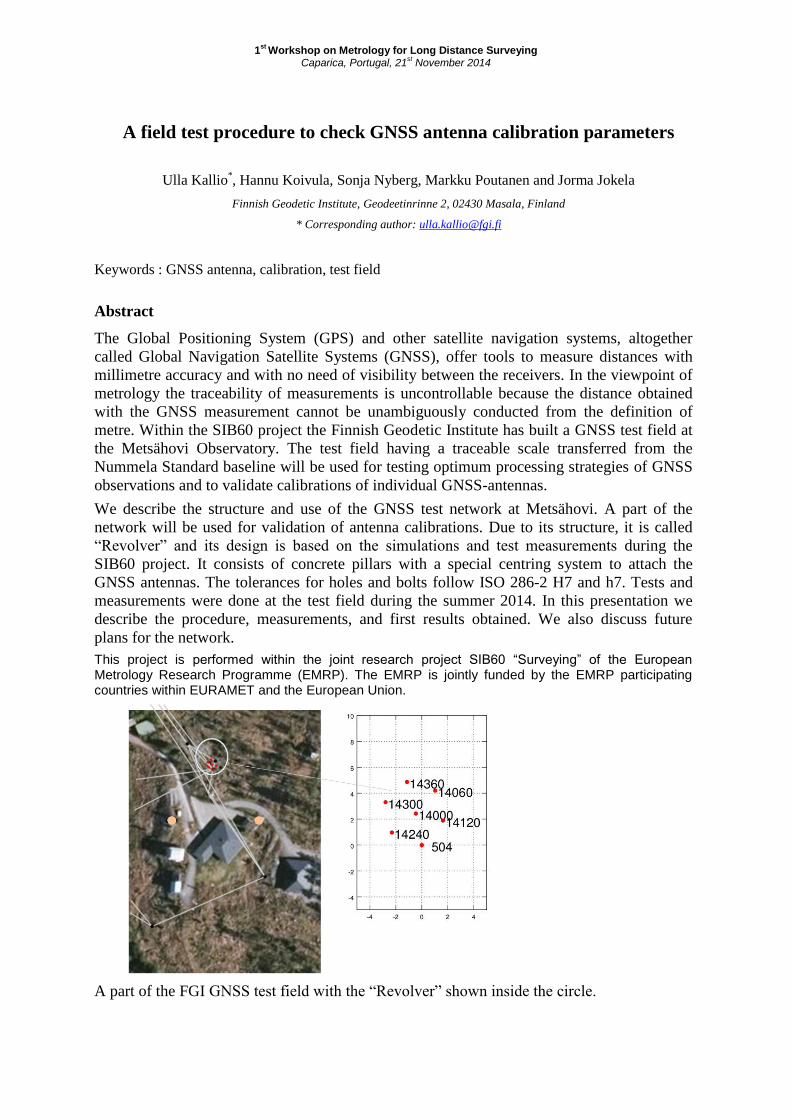
We describe the structure and use of the GNSS test network at Metsähovi. A part of the
network will be used for validation of antenna calibrations. Due to its structure, it is called
“Revolver” and its design is based on the simulations and test measurements during the
SIB60 project. It consists of concrete pillars with a special centring system to attach the
GNSS antennas. The tolerances for holes and bolts follow ISO 286-2 H7 and h7. Tests and
measurements were done at the test field during the summer 2014. In this presentation we
describe the procedure, measurements, and first results obtained. We also discuss future
plans for the network.
This project is performed within the joint research project SIB60 “Surveying” of the European Metrology Research Programme (EMRP). The EMRP is jointly funded by the EMRP participating countries within EURAMET and the European Union.
A part of the FGI GNSS test field with the “Revolver” shown inside the circle.
Metrology for Long Distance Surveying
IPQ, Caparica | Portugal | 21st November 2014
SESSION III
Traceable electronic distance meters
in air – towards novel standards
for baseline calibration
1st
Workshop on Metrology for Long Distance Surveying Caparica, Portugal, 21
st November 2014
Electronic Distance Meter Technology inside
Trimble’s Geospatial Instruments
Christian Graesser*, Martin Koehler
Trimble AB, 18211 Danderyd, Rinkebyvägen 11, Sweden
* Corresponding author: [email protected]
Keywords : Pulsed, phase-shift, distance meter, Laser, Trimble
Abstract
The presentation will give an insight into Trimble’s electronic distance meter (EDM)
technology used in the total stations and scanners. That includes the three different methods
phase shift EDM, pulsed averaging and direct sampling EDMs applied in the instruments.
The generation, sampling and evaluation of the signals will be presented as well as the
optical setup. The calibration and traceability of the measurement systems will complete the
talk.
1st
Workshop on Metrology for Long Distance Surveying Caparica, Portugal, 21
st November 2014
Spectroscopic inline thermometry
T Hieta1,*
, T Fordell1, M Vainio
1,2, M Merimaa
1
1 Centre for Metrology and Accreditation (MIKES),Tekniikantie 1, Espoo 02151, Finland
2 Laboratory of Physical Chemistry, Department of Chemistry, A. I. Virtasen aukio 1, University of Helsinki, Helsinki 00014,
Finland
* Corresponding author: [email protected]
Keywords : laser spectroscopy, refractive index of air, air temperature, interferometry
Abstract
In optical distance measurements it is essential to know the refractive index of air with high
accuracy. Commonly, the refractive index of air is calculated from the properties of the
ambient air using either Ciddor or Edlén equations, where the dominant uncertainty
component is in most cases air temperature. The method developed in MIKES utilises direct
absorption laser spectroscopy of oxygen to measure the average temperature of air. The
method allows measurement of temperature over the same beam path than in optical distance
measurement, providing spatially well matching data. Indoor and outdoor measurements
demonstrate the effectiveness of the developed method.
The MIKES work in SURVEYING EMRP project aims to extend the measurement distance
of oxygen thermometer up to 1 km using simplified single laser set-up for extra robustness
and simplicity. The new set-up designed for field applications include large diameter optics
and separate transmitting and receiving end.
The EMRP project SIB60 “Surveying” is jointly funded by the EMRP participating countries
within EURAMET and the European Union.
1st
Workshop on Metrology for Long Distance Surveying Caparica, Portugal, 21
st November 2014
A 1550 nm telemeter for outdoor application based on off-the-shelf
components
J. Guillory1, J. G. Marquez
1, A.-F. Obaton
1, D. Truong
1, C. Alexandre
2 and J.-P. Wallerand
1*
1 Laboratoire Commun de Métrologie (LNE – Cnam), 1 rue Gaston Boissier, 75015 Paris, France
2 Conservatoire National des Arts et Métiers (Cnam), Laboratoire CEDRIC/LAETITIA, 292 rue St-Martin, 75003 Paris, France
* Corresponding author: [email protected]
Keywords: optical telemetry, phase measurement, intensity modulation, absolute distance meter.
Abstract
We will present at the workshop the development of a telemeter based on an intensity-
modulated laser diode. It has the advantage to be more robust than classical fringe counting
interferometers, especially for long-distance outdoor propagation, and less expensive than
superheterodyne synthetic-wavelength interferometers [1]. For such a system, we aim a
relative resolution of 10-7
, i.e. some micrometers at short range or 100 µm over 1 km.
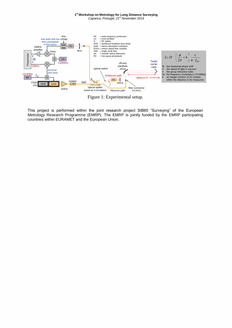
In this telemeter, depicted in Figure 1, the distance D is determined by measuring the phase
shift Φ accumulated by a Radio Frequency (RF) carrier that has been transposed in the
optical domain and propagated in free space until a reflective target. The calculation of this
distance is detailed in Figure 1.
In practice, we use affordable optoelectronic components coming from the
telecommunication world. Thus, an optical beam at 1550 nm is emitted by a Distributed
FeedBack laser diode (DFB), RF modulated by an Electro-Absorption Modulator (EAM) and
boosted by an Erbium-Doped Fiber Amplifier (EDFA). The signal is then propagated in free
space: an off-axis parabolic mirror collimates the beam at the fiber output, and after
reflection on a corner cube, reinjects it in the same fiber. Lastly, the optical signal is
converted by a free-space photodiode into an electrical one and down-converted at 10 MHz
since our phasemeter cannot directly measure high frequencies. An optical switch has also
been implemented in the setup to compare successively the measured distance to a reference
distance that does not vary during the measurement process. Thus, every variation observed
on the reference path is interpreted as a drift from the system (temperature evolution) and is
removed.
Tests have been performed outdoor, during a sunny day with temperatures ranging from 32
to 34 °C over a 100 m length asphalt road. In these harsh conditions that induce strong air
turbulences, the optical beam was affected by a large intensity noise. The latter was
converted by the reception chain in phase noise, but by selecting the phase values of same
amplitudes, a standard deviation less than 25 µm has been reached for a 1310 MHz
modulation frequency.
The next step will consist in determining the temperature along the optical path with a
precision of ± 0.1 °C, which is the required accuracy for the air index calculation. To this end,
a second wavelength at 780 nm will be added to the system. Thus, the measured distance will
be corrected taking advantage of the dependence of the chromatic dispersion of the refractive
index with air temperature [2] [3].
[1] S. Azouigui et al., Rev. Sci. Instrum., 81, 053112, 2010.
[2] K.B. Earnshaw et al., Appl. Opt., Vol. 11, Issue 4, 1972.
[3] K. Meiners-Hagen et al., Meas. Sci. Technol., 19, 2008.
1st
Workshop on Metrology for Long Distance Surveying Caparica, Portugal, 21
st November 2014
Figure 1: Experimental setup.
This project is performed within the joint research project SIB60 “Surveying” of the European Metrology Research Programme (EMRP). The EMRP is jointly funded by the EMRP participating countries within EURAMET and the European Union.
lens
RF
LOS
S
mixer
Ph
ase
mete
r
10MHz.
amplifier
Reference path
single
chipEAMDFB
PDbias
tee
Bias
voltage
Att.
RF = radio frequency synthesizerLO = local oscillator
S = RF splitter
DFB = distributed feedback laser diode
EAM = electro-absorption modulator
EDFA = erbium doped fiber amplifier
SMF = single mode fiber
Att. = variable optical attenuator
PD = free-space photodiode
optical splitter
(used as a circulator)
off-axis
parabolic
mirror
distance D
Target
fiber connector(FC/APC)
corner
cube
Measure path
optical switch
Φ
sine wave that has
been propagated
in free-space
electrical
sine wave
10MHz
1310MHz
1300MHz
mirror
EDFA
SMFisolator
RFfn
ckD
22
ΦCnfRFk
the measured phase shiftthe speed of light in vacuumthe group refractive indexthe frequency modulation (1310MHz)an integer number of 2π modulowithin the distance to be measured.
RFf
1st
Workshop on Metrology for Long Distance Surveying Caparica, Portugal, 21
st November 2014
A refractivity-compensated absolute distance interferometer as prospective
novel primary standard for baseline calibrations
Karl Meiners-Hagen1,*
, Florian Pollinger1 and Alen Bošnjakovic
2
1 Physikalisch-Technische Bundesanstalt (PTB), Bundesallee 100, D-38116 Braunschweig
2 Institut za mjeriteljstvo Bosne i Hercegovine (IMBiH), Augusta Brauna 2, BA-71000 Sarajevo, Bosnia and Herzegovina
* Corresponding author: [email protected]
Keywords: EDM calibration, refractivity compensation, multi-wavelength interferometry, surveying
Abstract
Traceable calibrations of geodetic baselines based on optical distance metrology are limited
by the influence of the refractive index of air. Especially the knowledge of the air
temperature in the measuring path limits the accuracy since the temperature distribution
depends heavily on the weather conditions.
Within the EURAMET joint research project SIB60 ‘Metrology for long distance surveying’
an absolutely measuring heterodyne interferometer is developed for a measuring range of
1 km with a targeted accuracy of 0.1 mm. The refractive index of air as the dominating
uncertainty source for interferometric length measurement is compensated by the two-color
method which based on the knowledge of dispersion. This device is intended as a future
primary standard for baseline calibrations.
Two frequency doubled Nd:YAG lasers emitting both wavelengths at 532 nm and 1064 nm
are the light sources for the interferometer. The frequency of one laser is stabilised onto the
other with a frequency difference of 20 GHz at 1064 nm, corresponding to 40 GHz at 532 nm
wavelength. The resulting synthetic wavelengths of 15 mm and 7.5 mm are used for the
length measurement. Therefore, the unambiguous measuring range is limited to only 7.5 mm
for this approach. To increase the unambiguous measuring range, longer synthetic
wavelengths are generated by acousto-optic frequency shifters which are also used for the
generation of the heterodyne frequencies. The results of the long synthetic wavelengths are
used to get the fringe order of the short ones resulting in a large measuring range with the
uncertainty determined solely by the short synthetic wavelengths.
The results for 532 nm and 1064 nm deliver optical path lengths corresponding to the
mechanical length multiplied by the refractive index of air for each wavelength. Due to the
dispersion in air the optical path lengths differ by an amount of approximately 4 µm/m. The
effective refractive index of air can be calculated from this difference which resolves the
typical problems of the outdoor measurement of the environmental parameters.
The interferometer head which is typically mounted on a pillar of a baseline is designed to
ensure outdoor capability and compatibility with standard geodetic equipment.
First results with this interferometer at the 50 m interference comparator of the PTB will be
presented.
This project is performed within the joint research project SIB60 “Surveying” of the
European Metrology Research Programme (EMRP). The EMRP is jointly funded by the
EMRP participating countries within EURAMET and the European Union
Metrology for Long Distance Surveying
IPQ, Caparica | Portugal | 21st November 2014
SESSION IV
Frequency-comb based distance
metrology – fundamental technology
for future application
1st
Workshop on Metrology for Long Distance Surveying Caparica, Portugal, 21
st November 2014
Heterodyne many-wavelength interferometry
Jutta Mildner1,*
, Karl Meiners-Hagen1 and Florian Pollinger
1
1 Physikalisch-Technische Bundesanstalt (PTB), Bundesallee 100, 38116 Braunschweig, Germany
* Corresponding author: [email protected]
Keywords: length metrology, femtosecond frequency comb, many-wavelength interferometry,
MSTAR
Abstract
Up-to-date long distance metrology in engineering, geodesy and surveying ask for relative
measurement uncertainties of better than 10-7
, which are not available yet. A promising tool
to push optical-based measurement techniques into this regime are broadband optical
frequency combs. These sources offer the opportunity to generate synthetic wavelengths
from the optical to the microwave range and are capable of directly tracing the measured
distance to the SI definition of the metre.
In this contribution we present a novel concept of a heterodyne many-wavelength
interferometer based on only one frequency comb in contrast to different approaches1.
Inspired by the MSTAR demodulation method2 a direct heterodyne phase detection of
individual comb lines is aimed at. To this end a single high-repetition rate fiber-based optical
frequency comb with stabilized carrier envelope offset (CEO) is used as a seed laser. By
cavity-filtering two coherent combs of different mode spacing in the GHz band are generated
and subsequently used as local oscillator and measurement beam for heterodyne
interferometry. Based on this scheme, a complete chain of synthetic wavelengths from the
macroscopic (millimetre regime) to the interferometric range (nanometre resolution) can be
realized in theory, making full phase unwrapping possible without additional high-accuracy
information. This large dynamic range together with the opportunity of more robust optical
set-ups would pave the way for future applications in surveying and engineering.
Development and demonstration of a prototype filtering unit with tuneable spacing in the
super high frequency (SHF) band will be presented, including simulations and experiments
on positioning sensitivity. Furthermore, we want to discuss the deployed stabilization
schemes as well as current progress on optimization measures.
This project is performed within the joint research project SIB60 “Surveying” of the
European Metrology Research Programme (EMRP). The EMRP is jointly funded by the
EMRP participating countries within EURAMET and the European Union.
1I. Coddington, W. C. Swann, L. Nenadovic and N. R. Newbury, Nature Photonics 3, 351 (2009)
2O. P. Lay, S. Dubovitsky, R. D. Peters, J. P. Burger, S.-W. Ahn, W. H. Steier, H. R. Fetterman and Y. Chang,
Opt. Lett. 28, 890 (2003)
1st
Workshop on Metrology for Long Distance Surveying Caparica, Portugal, 21
st November 2014
Spectrally resolved frequency comb interferometry for long distance
measurement
Steven A. van den Berg1,*
, Sjoerd van Eldik2 and Nandini Bhattacharya
2
1 VSL, Thijsseweg 11, 2629 JA, Delft, The Netherlands
2 Technische Universiteit Delft, Lorentzweg 1, 2628 CJ Delft, The Netherlands
* Corresponding author: [email protected]
Keywords : frequency comb, interferometry, distance metrology, high-resolution spectroscopy
Abstract
The invention of the femtosecond frequency comb has been a step change in the field of
optical-frequency metrology, with a wide outreach to other fields, like high-resolution
spectroscopy, femtosecond-pulse shaping and absolute distance measurement. A fs comb
frequency comb laser emits a spectrum consisting of equally spaced optical frequencies, with
a mutual spacing equal to the repetition frequency of the laser. We have investigated the
femtosecond frequency comb as a potential new source for accurate absolute long-distance
measurements, exploiting the unique properties of the comb and utilizing the direct
traceability to the SI second. The latter is realized by phase locking the frequency comb to an
atomic clock. In this contribution we focus on distance measurement with a mode-resolved
frequency comb laser. The frequency comb light is sent into a Michelson interferometer,
consisting of a measurement and a reference arm. Subsequently, the interferometer output is
analyzed with a high resolution spectrometer based on a virtually imaged phase array (VIPA)
and a grating. The VIPA spectrometer unravels the 1~GHz spaced comb frequencies to
distinct modes. As a result, interferometry on the level of individual modes (wavelengths)
can be observed. The distance is determined from both spectral interferometry and massively
parallel homodyne interferometry of about 9000 frequency comb modes. We have delivered
an experimental proof of principle of homodyne frequency comb interferometry by
measuring a short displacement with an unraveled comb and a counting helium-neon laser
simultaneously, showing an agreement of tens of nanometers[1]. Recently, we have extended
the measurement range to tens of meters, which – according to preliminary results – shows
an agreement within 10-7
, relative to the counting helium-neon laser that probes the same
interferometer displacement for comparison. This application of a fs frequency comb for
distance measurement can be considered as a combination of multiwavelength
interferometry with thousands of continuous wave (cw) lasers and spectral (dispersive)
interferometry. It overcomes the limitations of the individual techniques, combining an
interferometric scheme with a large range of non-ambiguity. This allows for non-incremental
absolute measurement of an arbitrary distance with a single frequency comb laser.
Reference
[1] S.A. van den Berg, G.J.P. Kok, S.T. Persijn, M.G. Zeitouny and N. Bhattacharya, Many-
wavelength interferometry with thousands of lasers for absolute distance measurement,
Phys. Rev. Lett. 108 183901 (2012)

Metrology for Long Distance Surveying
IPQ, Caparica | Portugal | 21st November 2014
POSTER SESSION
1st
Workshop on Metrology for Long Distance Surveying Caparica, Portugal, 21
st November 2014
Common-clock experiments with GNSS-based distance meters
Julia Leute1,*
, Thomas Krawinkel2, Andreas Bauch
1 and Steffen Schön
2
1 Physikalisch-Technische Bundesanstalt (PTB), Bundesallee 100, 38116 Braunschweig, Germany
2 Leibniz Universität Hannover, Institut für Erdmessung, Schneiderberg 50, 30167 Hannover, Germany
* Corresponding author: [email protected]
Keywords : GNSS-based distance meters, common-clock, troposphere
Abstract
Connecting two GNSS receivers to the same external frequency (“common-clock”) enables
an analysis based on single-difference carrier phase observations without determining the
receiver clock error at every epoch. At baselines of different length this setup is used to study
tropospheric effects on GNSS-based distance measurements.
Common-clock GNSS experiments on a short (ca. 250 m) and a very short baseline (ca. 5 m)
were carried out from October 16th to 30th 2013 at PTB. Absolutely calibrated antennas
were used to suppress antenna effects. The setup included geodetic receivers from different
manufacturers to study the effects of receiver choice.
In March 2014 zero baseline experiments were performed to investigate the effect of
different external frequency standards.
Results of the single-difference analysis of various baselines will be presented.
This project is performed within the joint research project SIB60 “Surveying” of the
European Metrology Research Programme (EMRP). The EMRP is jointly funded by the
EMRP participating countries within EURAMET and the European Union.
1st
Workshop on Metrology for Long Distance Surveying Caparica, Portugal, 21
st November 2014
Uncertainties of GNSS baselines related to ITRF
W. Niemeier10
, D. Tengen10
, C. Homann10
,
10 Technische Universität Braunschweig, Institut für Geodäsie und Photogrammetrie, Pockelsstraße 3, 38106 Braunschweig,
Germany
Keywords: local tie, uncertainties, Monte Carlo simulation
Abstract
Local tie measurements determine the coordinate differences between reference points of
different space geodetic sensors.
Coordinate differences are required in ITRF or the IGS realization of the ITRF.
Using IGS precise ephemerides GNSS baselines (coordinate differences) can be determined
in ITRF (IGS) system directly.
The coordinate differences determine the orientation of the net. This is important because
coordinate differences between reference points are needed no absolute coordinates.
Additional information of a combined network with GNSS and totalstation is desirable
because the accuracy of totalstation measurements is better than the accuracy or baselines
from GNSS.
Local tie networks of different extension (50m, 300m, 1000m) will be analyzed using Monte-
Carlo simulation.
Uncertainties according to GUM will be considered in the mentioned simulation for:
GNSS:
(antenna height, antenna calibration)
totalstation station:
(setup error, instrument- and target heights, angles, distances)
Additionally, instrumental errors and atmospheric effects will be modelled.
This project is performed within the joint research project SIB60 “Surveying” of the
European Metrology Research Programme (EMRP). The EMRP is jointly funded by the
EMRP participating countries within EURAMET and the European Union.
1st
Workshop on Metrology for Long Distance Surveying Caparica, Portugal, 21
st November 2014
The INRIM experimental set-up to characterize the effect of the turbulence
on the propagation of a laser beam in air
M. Zucco1,*
, M. Astrua1
1 Istituto Nazionale di Ricerca Metrologica (INRIM), Strada delle Cacce 91, 10135 Torino, Italy
* Corresponding author: [email protected]
Keywords: Turbulence, distance measurement
Abstract
The accuracy and stability of the measurement of distance in air with optical techniques is
limited by turbulence effects and by gradients of temperature. The turbulence vortices are
moved by wind or by convective motion across the laser beam causing the overall fluctuation
of the index of refraction and the wavefront distortion. At the same time, the presence of
gradients of temperature causes beam deflections and beam wandering.
These effects have an important influence on the laser beam used for distance measurement
or for optical communication. Phase fluctuations would add a phase jitter to the demodulated
signal and cause fluctuations in the measured distance. The beam wandering causes the
transversal displacement of the laser beam across the entrance aperture of the receiving set up
to cause an amplitude modulation that is translated into fluctuations of the measured distance.
Finally, beam bending is in addition induced by thermal gradients leading to longer optical
paths.
In particular, in case of beam bending, there are many theoretical and experimental studies in
literature of this effect based on turbulence theory. An early study relates the angle of arrival
with its variance [1]. From the structure parameter of the index of refraction it is possible to
obtain the correction to the geodetic measurement [2].
At INRIM a device is under development to characterize these effects. A first set-up is based
on a modulated laser at 1550 m that is split in two parallel beams having a variable distance.
By changing the beam distance and measuring the relative phase fluctuation between the two
transmitted beams it is possible to estimate the dimension of the vortices of the turbulence
and the kind of noise associated to the fluctuation. At the same time, the beam wandering and
deflection due to the gradient of the index of refraction in air is measured by measuring the
displacement of the spot on a position sensitive detector (PSD) and on a CCD camera. From
the PSD output it is possible to obtain a fast analysis of the wandering of the laser center of
mass. From the image taken from the camera it is possible to analyze the distortion of the
wavefront, at a lower rate. To measure in real time the temperature gradient in air an array of
fast thermometers has been developed. The device will be described and the first preliminary
measurements will be presented.
[1] F. K. Brunner, “Vertical Refraction Angle Derived from the Variance of the Angle-of-
Arrival Fluctuations”, In: E. Tengström und G. Teleki (Ed.), Refractional Influences in
Astrometry and Geodesy, Reidel Publ. pp. 227-238 (1979)
JRP SIB60 Surveying, 1. Workshop "Metrology for Long Distance Surveying", 21 November 2014, Caprice/Lissabon, Portugal
Poster contribution
Title: A GPS-‐based local-‐tie vector at the Onsala Space Observatory
Authors: Tong Ning, Rüdiger Haas, Gunnar Elgered
Affiliation: Chalmers University of Technology, Department of Earth and Space Sciences, Onsala Space Observatory, SE-‐439 92 Onsala (Sweden)
Abstract: So-‐called local-‐tie vectors at geodetic co-‐location stations are important pieces of information for the international terrestrial reference frame (ITRF). The Onsala Space Observatory is a co-‐location station contributing to the ITRF and operates equipment for geodetic Very Long Baseline Interferometry (VLBI) and Global Navigation Satellite System (GNSS) observations since several decades. The local-‐tie vector between the reference points of the instruments used at Onsala for VLBI and GNSS was previously observed several times by classical geodetic measurement techniques. In the summer of 2013 two gimbal-‐mounted GNSS-‐antennas were installed on the radio telescope, one on each side of the telescope dish, and several 24 hour long measurement campaigns were performed. Five semi-‐kinematic and four kinematic campaigns were conducted during July to September 2013. For the semi-‐kinematic campaigns, the telescope was pointed to different azimuth and elevation directions, spending up to 30 minutes at one position. The kinematic campaigns were conducted during normal geodetic VLBI-‐sessions where the telescope is continuously in motion and either tracking radio sources (slow motion) or slewing to new targets (fast motion). The GPS-‐data recorded with 1 Hz sampling during these campaigns were analyzed together with data from the ONSA site with a in-‐house developed software applying the double-‐difference analysis strategy with ambiguity-‐resolution. Phase-‐centre variation corrections were calculated for the rotated GNSS-‐antennas and applied in the data analysis. The resulting positions of the two GNSS-‐antennas on the telescope were used to determine its reference point and axis offset. Doing so, the so-‐called local-‐tie vector between the reference point of the telescope used for geodetic VLBI and the ONSA GNSS-‐monument was determined directly in the geocentric GPS-‐based reference frame. The results from the nine campaigns show standard deviations of 2.1 mm, 0.8 mm and 2.6 mm for the X, Y-‐ , and Z-‐axis respectively. The disagreement with respect to the coordinate differences calculated from the ITRF2008 coordinates of the reference points at epoch 2013 are 0.8 mm, 0.2 mm and 8.5 mm for the X-‐, Y-‐ and Z-‐components. The result for the axis offset has a standard deviation of 2.9 mm and differs by 0.5 mm from the results derived from classical geodetic measurements in 2002 and 2008.
1st
Workshop on Metrology for Long Distance Surveying Caparica, Portugal, 21
st November 2014
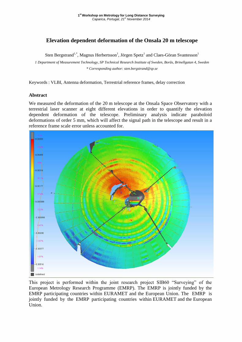
Elevation dependent deformation of the Onsala 20 m telescope
Sten Bergstrand1,*
, Magnus Herbertsson1, Jörgen Spetz
1 and Claes-Göran Svantesson
1
1 Department of Measurement Technology, SP Technical Research Institute of Sweden, Borås, Brinellgatan 4, Sweden
* Corresponding author: [email protected]
Keywords : VLBI, Antenna deformation, Terrestrial reference frames, delay correction
Abstract
We measured the deformation of the 20 m telescope at the Onsala Space Observatory with a
terrestrial laser scanner at eight different elevations in order to quantify the elevation
dependent deformation of the telescope. Preliminary analysis indicate paraboloid
deformations of order 5 mm, which will affect the signal path in the telescope and result in a
reference frame scale error unless accounted for.
This project is performed within the joint research project SIB60 “Surveying” of the
European Metrology Research Programme (EMRP). The EMRP is jointly funded by the
EMRP participating countries within EURAMET and the European Union. The EMRP is
jointly funded by the EMRP participating countries within EURAMET and the European
Union.
1st
Workshop - Metrology for Long Distance Surveying IPQ, Caparica, Portugal, 21
st November 2014
High accuracy laser ranging and amplitude to phase coupling
Michel Lintz 1*
, Duy-Ha Phung 1, Mourad Merzougui 1, and Christophe Alexandre 2
1 ARTEMIS, Observatoire de la Cote d'Azur, Bd de l'Observatoire, 06300 Nice, France
2 CNAM, 292 rue Saint Martin, 75003 Paris, France
* Corresponding author: [email protected]
Keywords : Laser ranging, phase measurement, amplitude-to-phase coupling, optical demodulation.
Abstract
High accuracy laser ranging often uses high frequency modulation of a laser beam. In our
laser ranging setup we use a 20GHz modulation, where both the optical wavelength and
synthetic wavelength information are encoded, to achieve nanometric precision. But the
principle of our measurement method implies large amplitude variations that give rise to
severe systematic effects through the amplitude-to-phase (AM-to-PM) coupling in the
photodiode. In long distance measurements in air, even if the measurement method implies
no variation of the beam power, significant variations, sometimes called "scintillation", can
result from atmospheric turbulence, due to the modification of the beam wavefront during
propagation.
The strategy that consists, prior to the ranging measurements, in recording the phase-vs-
intensity dependence with the aim of numerically correcting of the phase data does not fully
solve the problem: we observe that, in addition to the dependence with intensity, the phase
data exhibit a dependence as a function of the time after the optical power has changed. This
corresponds to the evolution of the temperature of the photodiode junction and substrate after
the dissipated Joule power (photocurrent X bias voltage) has changed.
We characterize this behavior, and study different ways to reduce amplitude to phase
coupling. Finally, we show that optical demodulation, rather than electrical demodulation, of
the high frequency optical modulation, allows to reject, by orders of magnitude, the
photodiode AM-to-PM coupling and associated systematic errors.
1st
Workshop on Metrology for Long Distance Surveying Caparica, Portugal, 21
st November 2014
Design of the external optical cavity for multiplication of repetition rate of
Er:dopped fs comb
Radek Šmíd, Adam Lešundák, Lenka Pravdová, and Ondřej Číp
Institute of Scientific Instruments of AS CR, v.v.i, Královopolská 147, 61264 Brno, Czech Republic
* Corresponding author: [email protected]
Keywords : Fabry-Perot cavity, laser frequency comb, repetition rate multiplication
Abstract
Optical frequency combs (OFCs) have spectrum composed of many equally spaced spectral
lines. They have already been employed in wide range of applications reaching from
astronomical spectrograph calibration, spectroscopy of gases, optical and microwave
waveform generation, synthesis of optical frequencies to RF domain in time and frequency
branch of metrology. Ability of controlling of frequencies of spectral components to extreme
precision and stability is the main advantage of this tool. The repetition rate of femtosecond
pulses defines frequency spacing between neighboring modes in the comb spectrum.
One of important application of combs is a long distance interferometry. Resolution of the
long distance measurement depends on the repetition rate of the optical frequency comb.
Commercially available solid state OFCs can reach the repetition rate up to 1 GHz (like
Ti:Sapphires) and they have enough optical power per each comb teeth. On the other hand
they are quite sensitive to the external mechanical vibrations and to cleanliness.
Commercially available Er-doped fibre OFCs can reach the repetition rate of 250 MHz. The
advantage of them is their robustness, they can be more easily transportable and they don’t
need high degree clean rooms. The laser repetition rate is limited physically by the length of
the laser cavity.
In outdoor application for long distance measurement is the fiber system more quite handy.
Therefore it is interesting to increase the repetition rate of the Er-doped OFC. In this work we
present the design of the external optical cavity based on Fabry-Pérot etalon (FPC) applied to
250 MHz Er-doped fiber OFC to increase its repetition rate. We constructed a Fabry-Perot
cavity (FPC) based on transportable cage system with two mirrors in plan-concave symmetry
including the mode-matching lenses, fiber coupled collimation package and detection unit.
The system enables full 3D angle mirror tilting and x-y off axis movement as well as distance
between the mirrors. The free spectral range of the FPC was 1 GHz therefore the distance
between the mirrors was set to 150 mm.
We compared the designed based on a plan-concave pair of silver mirrors with the pair of
dielectric mirrors. The silver mirrors deposited in our institute are made by (40.2+/-0.9) nm
silver layer. The transmission of 3.5 – 4.0 % and the reflectivity of 98.64% correspond to the
finesse of 195. Curved mirror radius was 800 mm. The commercially available pair of plan-
concave dielectric mirrors with group delay dispersion from 0 fs2 to -400 fs
2 at 1400-1800 nm
was compared with the pair of silver mirrors. The dielectric mirrors reflectivity is 99.8 % and
corresponds to finesse of 1569. The curved mirrors radiuses were 1000 mm.
The authors would like to thank for support to the projects GPP102/12/P962 and
GP102/10/1813 funded by Grant Agency of the Czech Republic.
1st
Workshop on Metrology for Long Distance Surveying Caparica, Portugal, 21
st November 2014
Femtosecond frequency comb mode selection by external optical cavity
A. Lesundak1, S. A. van den Berg
2
1 Institute of Scientific Instruments, Academy of Sciences of the Czech Republic, Krávopolská, 612 64 Brno, Czech Republic
2 National Metrology Institute VSL, Thijsseweg 11, 2629 JA Delft, The Netherlands
* Corresponding author: [email protected]
Keywords: traceability, Frequency comb, Fabry-Perot cavity, many-wavelength interferometry
Abstract
The topic of the research presented in this work is related to the Work Package 3, Task 3.1 of
JRP-SIB60 Surveying, which explores different application concepts of femtosecond laser-
based many-wavelength interferometry for long-distance metrology. This work presents a
research in selection of laser frequency comb modes – laser wavelengths – by an external
optical resonator. Ti:Sapphire pulsed laser frequency combs currently used for a massively
parallel homodyne interferometry for absolute distance measurements have large spacing
between adjacent comb modes. Those modes can be optically resolved, but this type of
frequency combs is very delicate, bulky and expensive. On the other hand, fiber laser based
frequency combs are much more suitable for field-applications, but they have narrower
spacing between individual comb modes, i.e. they have denser optical spectrum which is
impossible to resolve even with a high resolution VIPA spectrometer. Hence, reducing of the
comb modes number is necessary for field applications.
A Fabry-Perot cavity was used for this purpose and its performance was tested on Ti:Sa
frequency comb with the pulse repetition rate (spacing between modes) frep=1GHz, and the
central wavelength λc=815nm. The core of the cavity consists of two symmetrically arranged
high reflective dielectric concave mirrors with nearly zero chromatic dispersion. The cavity
acts as an optical filter transmitting only a fraction of the original spectrum. The design of the
overall setup, consisting of the cavity, mode-matching optics and cavity locking electronics,
allows a filtering ratio adjustment, selection of a transmission peak and a long-time stable
operation. We achieved the spacing between transmitted comb modes of 20GHz. In the case
when a cavity free spectral range is not an integer multiple of frequency comb repetition rate,
we achieved the spacing up to 101GHz.
The presented joint research project SIB60 “Surveying” receives funding by the European
Metrology Research Programme (EMRP). The EMRP is jointly funded by the EMRP
participating countries within EURAMET and the European Union.
1st
Workshop on Metrology for Long Distance Surveying Caparica, Portugal, 21
st November 2014
Dispersion compensation for absolute distance measurement
based on the femtosecond optical frequency comb
Tengfei Wu*, Li Zhang, Shuai Xing and Zhiguo Liang
Beijing Changcheng Institute of Metrology & Measurement, AVIC, Beijing 100095, China
* Corresponding author: [email protected]
Keywords : femtosecond, air dispersion, transmissive grating, compensation
Abstract
The effect of air dispersion on the femtosecond pulsed width is studied in this paper. We
present the pulsed width variation with central wavelength, grating period and distance,
respectively. Then the air dispersion compensation scheme based on the high-density
transmissive grating is put forward to compress the pulsed width of femtosecond laser. The
diffracted efficiencies variation with the groove depth and the grating period under the
condition of TE and TM polarization state are also given through simulation. The scheme has
advantages of compact volume and convenient operation.
1st
Workshop on Metrology for Long Distance Surveying Caparica, Portugal, 21
st November 2014
INVESTIGATION OF UNCERTAINTY OF GNSS-BASED DISTANCE
METROLOGY USING EPN DOUBLE STATIONS DATA
Aleksei Liubzhyn1, Pavel I. Neyezhmakov
1, Yevgen M. Zanimonskiy
1,2, Volodymyr S. Kupko
1,
Alla Y. Olijnyk1, Katarzyna Stepniak
3, Pawel Wielgosz
3, Jan Cisak
4, Lukasz Zak
4
1NSC "Institute of Metrology", Kharkiv, Ukraine
2Institute of Radio Astronomy of NAS, Kharkiv, Ukraine
3University of Warmia and Mazury in Olsztyn
4Institute of Geodesy and Cartography, Warsaw, Poland
* Corresponding author: [email protected]
Keywords : GNSS, EPN, distance metrology
Abstract
Nowadays surveyors and researchers in geosciences are facing the challenge of measuring
distances over several hundreds of meters up to 1 kilometer with uncertainties at a single
millimeter level and below. Electronic distance meters and GNSS are available for this task
and long length metrology complies with GNSS-based short distance measurements. Both
approaches, however, are currently not capable of achieving traceability to the SI definition
of the meter with one or even sub-millimeter uncertainty over the respective distances.
The presented results were obtained in the framework of a research project aimed at fostering
the measurements up to 1 kilometer traceability to SI units. This work is dedicated to a better
understanding of the uncertainty of GNSS-based distance metrology. The influence of the
troposphere, near-field effects and multipath on the distance measurements uncertainty will
be studied in optimized configurations.
The EUREF Permanent Network (EPN) is a network of continuously operating GNSS
reference stations maintained on a voluntary basis by EUREF (EUropean REference Frame)
members. The primary purpose of the EPN is to provide access to the European Terrestrial
Reference System (ETRS89) by making publicly available the GNSS tracking data as well as
the precise coordinates of all the EPN stations.
Long time series of vector components, derived from processing GNSS data from double
EPN stations, were generated. They provide extremely rich information on variability of
GNSS solutions that together with the external data enables qualitative and quantitative
analysis of those variations as well as their reliable statistical estimate.
The experiments performed concerned the investigation of the response of the measuring
system to tropospheric perturbations as well as to site specific effects vs. measured distance.
Numerical experiments conducted indicate that the potentiality of GNSS positioning is not
fully exploited in high-end applications. Also, analysis of time series of GNSS solutions may
result in improvement of modeling of GNSS observations and GNSS-based distance
metrology.

Rua António Gião, 2, 2829-513 Caparica | Portugal | Tel +351 212 948 136 Fax +351 212 948 223
www.ipq.pt