Embed Size (px)
Citation preview

A47 WANSFORD TO SUTTON DUALLING Design Development Report
Joint
Notice
This document has been prepared on behalf of Galliford Try by Sweco UK Ltd for Highways England's Delivery Integration Partners (DiP) Framework. It is issued for the party which commissioned it and for specific purposes connected with the above-captioned project only. It should not be relied upon by any other party or used for any other purpose. Sweco UK Ltd accepts no responsibility for the consequences of this document being relied upon by any other party, or being used for any other purpose, or containing any error or omission which is due to an error or omission in data supplied to us by other parties.
This document contains confidential information and proprietary intellectual property. It should not be shown to other parties without consent from Galliford Try.
A47 WANSFORD TO SUTTON DUALLING
Design Development Report
October 2020
HE551494-GTY-GEN-000-RP-ZX-00001 | P02
A47 WANSFORD TO SUTTON DUALLING Design Development Report
Prepared for:
Galliford Try
Cowley Business Park
Cowley
Uxbridge
Middlesex
UB8 2AL
Prepared by:
Sweco UK Ltd
Grove House
Mansion Gate Dr
Leeds
LS7 4DN
A47 WANSFORD TO SUTTON DUALLING Design Development Report
Table of contents
1. Scheme introduction 1
Introduction 1
Background 1
Statutory feedback 3
Purpose of this report 4
2. Design development 5
The 2020 design 5
West of the Scheduled Monument 5
East of the Scheduled Monument 13
3. Comparative assessment of 2018 design and the northern alignment 14
General 14
Engineering assessment 15
Environmental assessment 17
Traffic assessment 26
Costs 26
Outcome 27
4. Conclusion 28
Appendices
APPENDIX A - SCHEME LAYOUT 29
Figures
Figure 1.1 The preferred option as presented in August 2017 ................................... 2
Figure 1.2 The proposed design presented at statutory consultation (the 2018
design). ............................................................................................................ 3
Figure 2.1 The 2020 Design ....................................................................................... 5
Figure 2.2 Proposals for the western roundabout (Extract from Appendix A) ............. 6
Figure 2.3 Proposals for the A1 southbound to A47 eastbound slip road (Extract
from Appendix A) ............................................................................................. 7
Figure 2.4 Side road strategy (Extract from Appendix A) ........................................... 8
Figure 2.5 Walking, cycling and horse-riding strategy at the Wansford roundabouts
(Extract from Appendix A) ............................................................................... 9
Figure 2.6 Walking, cycling and horse-riding strategy west of the Scheduled
Monument (Extract from Appendix A) ............................................................ 10
Figure 2.7 Walking, cycling and horse-riding strategy east of the Scheduled
Monument (Extract from Appendix A) ............................................................ 11
Figure 2.8 Walking, cycling and horse-riding strategy east of the Scheduled
Monument (Extract from Appendix A) ............................................................ 12
Figure 3.1 The 2018 design ..................................................................................... 14
Figure 3.2 2020 northern alignment ......................................................................... 15
A47 WANSFORD TO SUTTON DUALLING Design Development Report
Tables
Table 3.1: Air quality comparative assessment ........................................................ 17
Table 3.2: Cultural heritage comparative assessment.............................................. 18
Table 3.3: Landscape and visual comparative assessment ..................................... 19
Table 3.4: Biodiversity comparative assessment ..................................................... 21
Table 3.5: Noise and vibration comparative assessment ......................................... 22
Table 3.6: Walkers, cyclists and horse-riders comparative assessment .................. 23
Table 3.7: Road drainage and the water environment comparative assessment ..... 24
Table 3.8: Climate comparative assessment ............................................................ 25
A47 WANSFORD TO SUTTON DUALLING Design Development Report
1
1. Scheme introduction
Introduction
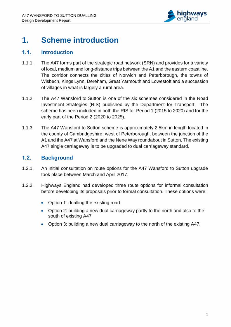
1.1.1. The A47 forms part of the strategic road network (SRN) and provides for a variety
of local, medium and long-distance trips between the A1 and the eastern coastline.
The corridor connects the cities of Norwich and Peterborough, the towns of
Wisbech, Kings Lynn, Dereham, Great Yarmouth and Lowestoft and a succession
of villages in what is largely a rural area.
1.1.2. The A47 Wansford to Sutton is one of the six schemes considered in the Road
Investment Strategies (RIS) published by the Department for Transport. The
scheme has been included in both the RIS for Period 1 (2015 to 2020) and for the
early part of the Period 2 (2020 to 2025).
1.1.3. The A47 Wansford to Sutton scheme is approximately 2.5km in length located in
the county of Cambridgeshire, west of Peterborough, between the junction of the
A1 and the A47 at Wansford and the Nene Way roundabout in Sutton. The existing
A47 single carriageway is to be upgraded to dual carriageway standard.
Background
1.2.1. An initial consultation on route options for the A47 Wansford to Sutton upgrade
took place between March and April 2017.
1.2.2. Highways England had developed three route options for informal consultation
before developing its proposals prior to formal consultation. These options were:
Option 1: dualling the existing road
Option 2: building a new dual carriageway partly to the north and also to the south of existing A47
Option 3: building a new dual carriageway to the north of the existing A47.
A47 WANSFORD TO SUTTON DUALLING Design Development Report
2
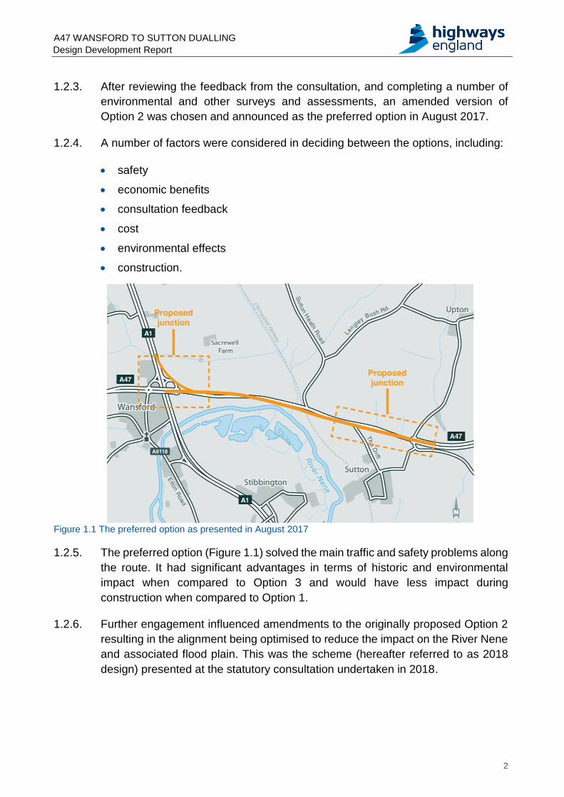
1.2.3. After reviewing the feedback from the consultation, and completing a number of
environmental and other surveys and assessments, an amended version of
Option 2 was chosen and announced as the preferred option in August 2017.
1.2.4. A number of factors were considered in deciding between the options, including:
safety
economic benefits
consultation feedback
cost
environmental effects
construction.
Figure 1.1 The preferred option as presented in August 2017
1.2.5. The preferred option (Figure 1.1) solved the main traffic and safety problems along
the route. It had significant advantages in terms of historic and environmental
impact when compared to Option 3 and would have less impact during
construction when compared to Option 1.
1.2.6. Further engagement influenced amendments to the originally proposed Option 2
resulting in the alignment being optimised to reduce the impact on the River Nene
and associated flood plain. This was the scheme (hereafter referred to as 2018
design) presented at the statutory consultation undertaken in 2018.
A47 WANSFORD TO SUTTON DUALLING Design Development Report
3
Statutory feedback
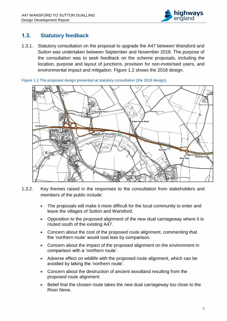
1.3.1. Statutory consultation on the proposal to upgrade the A47 between Wansford and
Sutton was undertaken between September and November 2018. The purpose of
the consultation was to seek feedback on the scheme proposals, including the
location, purpose and layout of junctions, provision for non-motorised users, and
environmental impact and mitigation. Figure 1.2 shows the 2018 design.
Figure 1.2 The proposed design presented at statutory consultation (the 2018 design).
1.3.2. Key themes raised in the responses to the consultation from stakeholders and
members of the public include:
The proposals will make it more difficult for the local community to enter and leave the villages of Sutton and Wansford.
Opposition to the proposed alignment of the new dual carriageway where it is routed south of the existing A47.
Concern about the cost of the proposed route alignment, commenting that the ‘northern route’ would cost less by comparison.
Concern about the impact of the proposed alignment on the environment in comparison with a ‘northern route’.
Adverse effect on wildlife with the proposed route alignment, which can be avoided by taking the ‘northern route’.
Concern about the destruction of ancient woodland resulting from the proposed route alignment.
Belief that the chosen route takes the new dual carriageway too close to the River Nene.
A47 WANSFORD TO SUTTON DUALLING Design Development Report
4
Concern about land take resulting from the proposed route option. Most of these comments state that the proposed route uses privately owned land of high amenity and environmental value, whereas the ‘northern route’ would use lower-quality land.
Concern about an increase in traffic on the new dual carriageway, which will make it more difficult to exit Old North Road, creating a hazard to those living in Wansford.
Concern regarding safety issues arising from the western roundabout proposals. Many of these believe an increase in traffic on the new dual carriageway will make it more difficult to exit Old North Road and Thackers Close, increasing the likelihood of accidents occurring.
Concern that congestion will increase at the Nene Way roundabout as a result of the introduction of peak time traffic signals.
The Nene Way roundabout should be replaced with an alternative junction type. The most common suggestion is an overpass or underpass, or a grade-separated junction followed by a dumbbell junction.
The existing A47 should be used as a road for local traffic, walkers, cyclists and horse-riders with the new dual carriageway built to the north.
Purpose of this report
1.4.1. Since the statutory consultation in 2018 a full design review has taken place to
take into consideration the feedback received.
1.4.2. The design review has resulted in some key changes to the scheme design.
Further targeted consultation and engagement is therefore being undertaken. The
purpose of this report is to explain the changes and present the comparative
assessment of the key change to the design.
A47 WANSFORD TO SUTTON DUALLING Design Development Report
5
2. Design development
The 2020 design
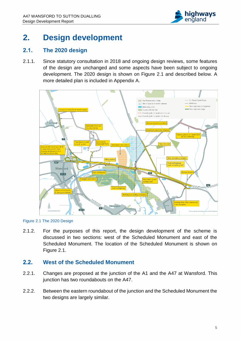
2.1.1. Since statutory consultation in 2018 and ongoing design reviews, some features
of the design are unchanged and some aspects have been subject to ongoing
development. The 2020 design is shown on Figure 2.1 and described below. A
more detailed plan is included in Appendix A.
Figure 2.1 The 2020 Design
2.1.2. For the purposes of this report, the design development of the scheme is
discussed in two sections: west of the Scheduled Monument and east of the
Scheduled Monument. The location of the Scheduled Monument is shown on
Figure 2.1.
West of the Scheduled Monument
2.2.1. Changes are proposed at the junction of the A1 and the A47 at Wansford. This
junction has two roundabouts on the A47.
2.2.2. Between the eastern roundabout of the junction and the Scheduled Monument the
two designs are largely similar.
A47 WANSFORD TO SUTTON DUALLING Design Development Report
6
Wansford roundabouts
2.2.3. The proposals for the western roundabout at Wansford have been amended and
now include:
improved entry from the A1 northbound diverge slip road
improved exit to the A47 eastbound
a new segregated left turn lane (SLTL) between A1 northbound slip road and A47 eastbound
a new cycle crossing of the A47 west of the roundabout, removing cycle traffic from the A1 overbridge
Figure 2.2 Proposals for the Wansford roundabouts (Extract from Appendix A)
2.2.4. The proposals for the eastern roundabout include:
an enlarged roundabout diameter
a new arm to the south of the roundabout, providing access to Sacrewell Farm and the Service Station
2.2.5. The improvements to the eastern roundabout at the A1 are largely similar to the
2018 design, except on the connector road between the roundabout and the A1.
The large widened physical island between the lanes that was proposed in 2018
has been amended to include appropriate widening only.
A47 WANSFORD TO SUTTON DUALLING Design Development Report
7
A1 southbound to A47 eastbound slip road
2.2.6. The alignment of the A1 southbound to A47 eastbound slip road has been refined
to reduce the amount of earthworks required to construct the slip road.
2.2.7. Due to the proximity of the proposed southbound A1 to A47 slip road, the 2020
design removes the bus stop and the direct access to the A1 from the properties
adjacent to Windgate Way (see Figure 2.3).
Figure 2.3 Proposals for the A1 southbound to A47 eastbound slip road (Extract from Appendix A)
2.2.8. The proposed access to the properties will be via the existing A1 Sacrewell Lodge
junction and will utilise an existing former section of the A1 that runs south to the
Great North Road houses. This will increase the distance between the access to
the properties and the slip road, required for safety reasons.
A47 WANSFORD TO SUTTON DUALLING Design Development Report
8
Side road strategy
2.2.9. The proposed Sacrewell Farm and Service Station access roads are similar to the
2018 design. The 2020 design has a reduced skew length for the structure below
the A47. The westbound A47 diverge to the Service Station has been moved west
in order to reduce the required visibility widening at the Scheduled Monument.
Figure 2.4 Side road strategy (Extract from Appendix A)
A47 WANSFORD TO SUTTON DUALLING Design Development Report
9
Walking, cycling and horse-riding (WCHR) strategy
2.2.10. At the western roundabout the existing off-road cycle crossing will be replaced
with new crossings for cyclists on the A47 western arm and the southern arm. The
new crossings will allow cyclists to connect between the existing A47 and the on-
road cycle route into Wansford via the Old North Road. From here, pedestrians,
cyclists and equestrians will be able to connect to the proposed routes to the east
of the A1 via Peterborough Road, the A1 underpass, and the recently improved
route to the Wansford picnic area.
Figure 2.5 Walking, cycling and horse-riding strategy at the Wansford roundabouts (Extract from Appendix A)
A47 WANSFORD TO SUTTON DUALLING Design Development Report
10
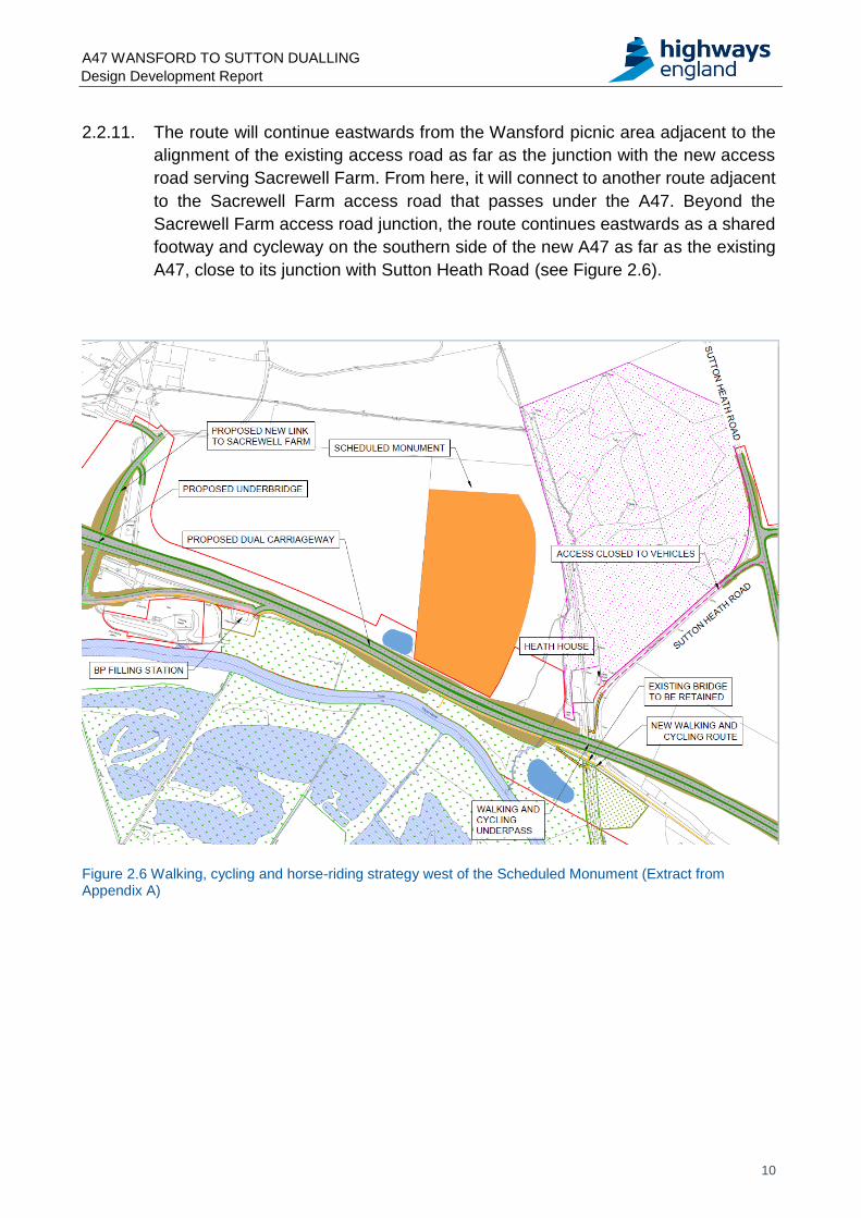
2.2.11. The route will continue eastwards from the Wansford picnic area adjacent to the
alignment of the existing access road as far as the junction with the new access
road serving Sacrewell Farm. From here, it will connect to another route adjacent
to the Sacrewell Farm access road that passes under the A47. Beyond the
Sacrewell Farm access road junction, the route continues eastwards as a shared
footway and cycleway on the southern side of the new A47 as far as the existing
A47, close to its junction with Sutton Heath Road (see Figure 2.6).
Figure 2.6 Walking, cycling and horse-riding strategy west of the Scheduled Monument (Extract from Appendix A)
A47 WANSFORD TO SUTTON DUALLING Design Development Report
11
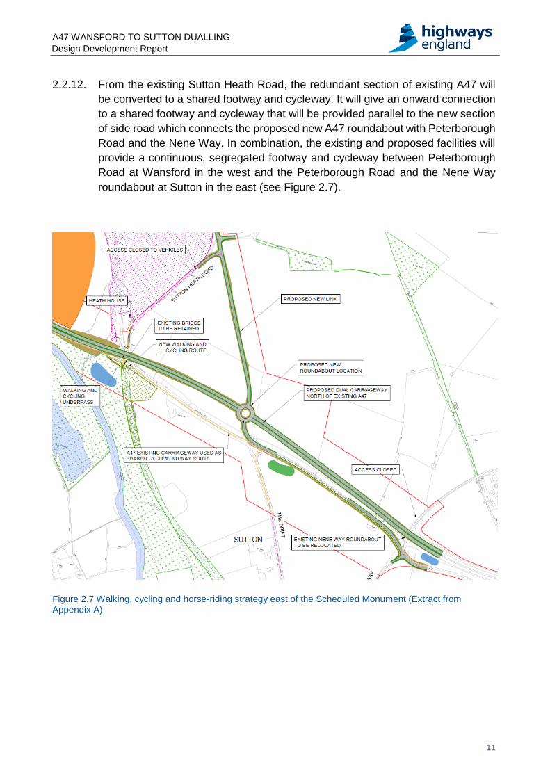
2.2.12. From the existing Sutton Heath Road, the redundant section of existing A47 will
be converted to a shared footway and cycleway. It will give an onward connection
to a shared footway and cycleway that will be provided parallel to the new section
of side road which connects the proposed new A47 roundabout with Peterborough
Road and the Nene Way. In combination, the existing and proposed facilities will
provide a continuous, segregated footway and cycleway between Peterborough
Road at Wansford in the west and the Peterborough Road and the Nene Way
roundabout at Sutton in the east (see Figure 2.7).
Figure 2.7 Walking, cycling and horse-riding strategy east of the Scheduled Monument (Extract from Appendix A)
A47 WANSFORD TO SUTTON DUALLING Design Development Report
12
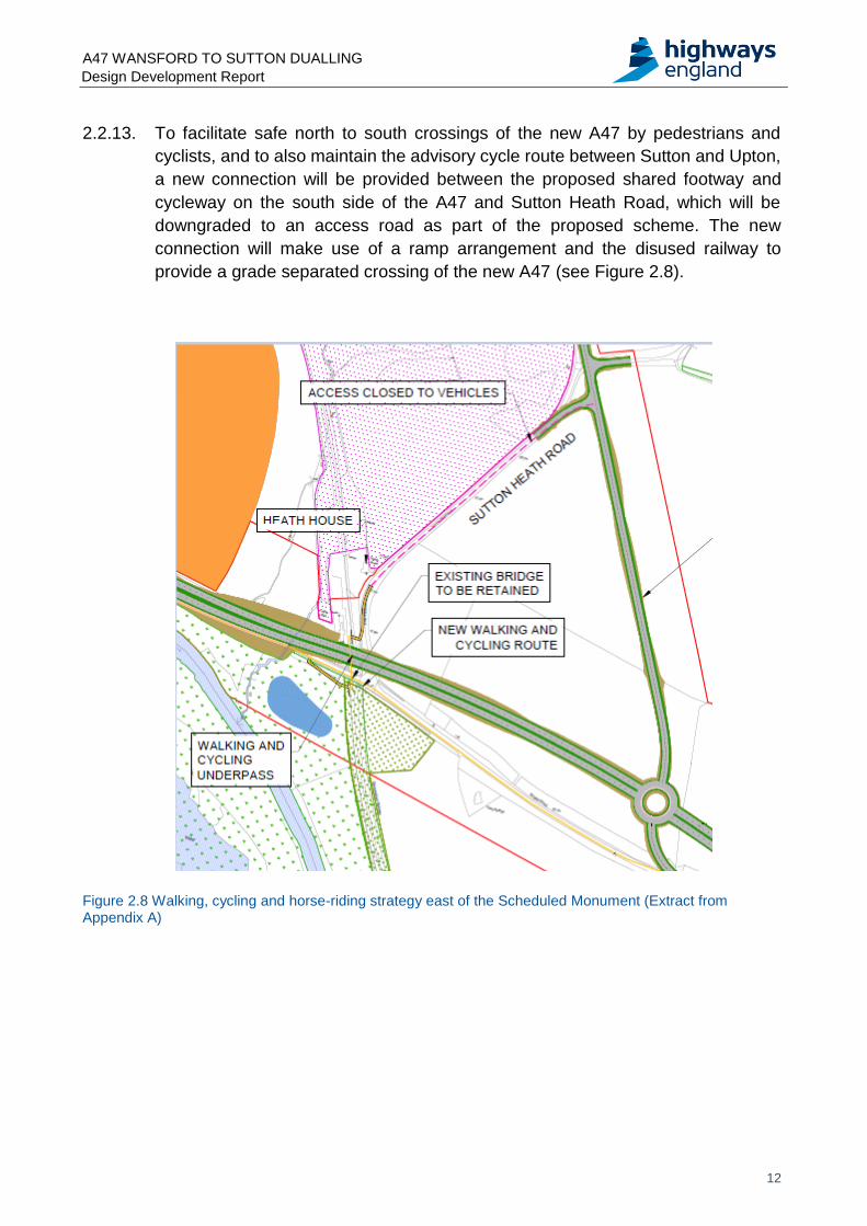
2.2.13. To facilitate safe north to south crossings of the new A47 by pedestrians and
cyclists, and to also maintain the advisory cycle route between Sutton and Upton,
a new connection will be provided between the proposed shared footway and
cycleway on the south side of the A47 and Sutton Heath Road, which will be
downgraded to an access road as part of the proposed scheme. The new
connection will make use of a ramp arrangement and the disused railway to
provide a grade separated crossing of the new A47 (see Figure 2.8).
Figure 2.8 Walking, cycling and horse-riding strategy east of the Scheduled Monument (Extract from Appendix A)
A47 WANSFORD TO SUTTON DUALLING Design Development Report
13
East of the Scheduled Monument
2.3.1. Following the feedback to the statutory consultation in 2018, it was noted that
many stakeholders would prefer the route to be aligned north of the existing A47.
A route entirely north of the existing A47 between Wansford and Sutton was
determined not to be feasible due to the environmental constraints. A route north
of the existing A47 between Sutton Heath Road and the Nene Way roundabout to
the east of the Scheduled Monument has therefore been designed and assessed.
A comparative assessment between the 2018 design in this section and an
alternative northern alignment is set out in Section 3 below and illustrated on
Figures 3.1 and 3.2.
A47 WANSFORD TO SUTTON DUALLING Design Development Report
14
3. Comparative assessment of 2018 design and the northern alignment
General
3.1.1. The design developed following the statutory consultation in 2018 east of the
Scheduled Monument has been assessed against an alternative northern
alignment developed in 2020. Engineering, environment, traffic and costs have
been considered in order to determine the best solution.
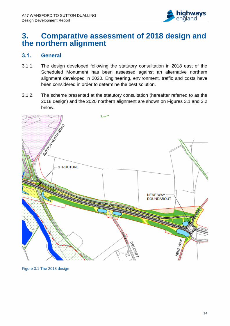
3.1.2. The scheme presented at the statutory consultation (hereafter referred to as the
2018 design) and the 2020 northern alignment are shown on Figures 3.1 and 3.2
below.
Figure 3.1 The 2018 design
A47 WANSFORD TO SUTTON DUALLING Design Development Report
15
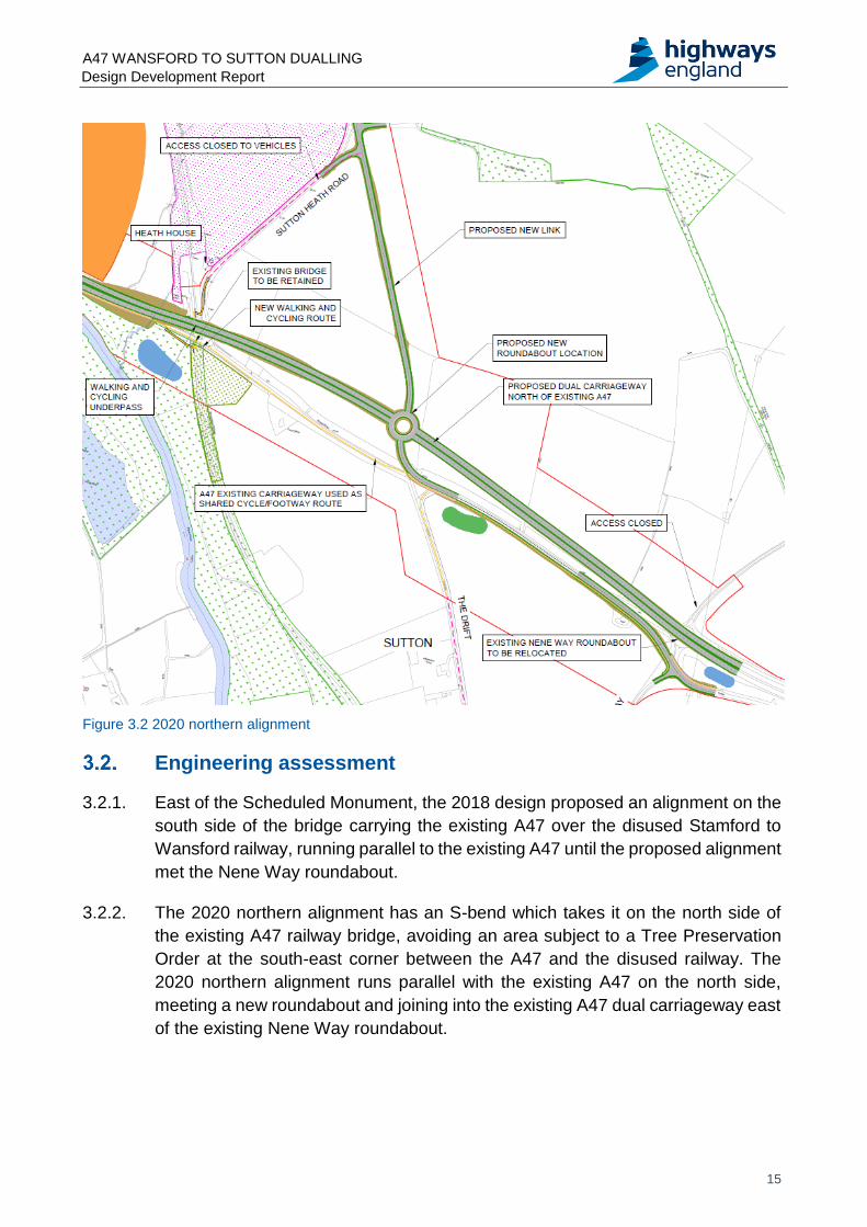
Figure 3.2 2020 northern alignment
Engineering assessment
3.2.1. East of the Scheduled Monument, the 2018 design proposed an alignment on the
south side of the bridge carrying the existing A47 over the disused Stamford to
Wansford railway, running parallel to the existing A47 until the proposed alignment
met the Nene Way roundabout.
3.2.2. The 2020 northern alignment has an S-bend which takes it on the north side of
the existing A47 railway bridge, avoiding an area subject to a Tree Preservation
Order at the south-east corner between the A47 and the disused railway. The
2020 northern alignment runs parallel with the existing A47 on the north side,
meeting a new roundabout and joining into the existing A47 dual carriageway east
of the existing Nene Way roundabout.
A47 WANSFORD TO SUTTON DUALLING Design Development Report
16
3.2.3. The 2018 design had one identified departure from the standards which apply to
the SRN. This was a relaxation in the vertical sag curve at the approach to the
Nene Way roundabout.
3.2.4. The 2020 northern alignment currently has two departures. These are reductions
in the westbound stopping sight distance (SSD) on both the nearside and offside
lanes on the approach to the A1 Wansford junction. In both cases, however, it is
anticipated that these can be resolved as the design progresses.
3.2.5. The 2018 design included an enlargement to the existing Nene Way roundabout.
The 2020 northern alignment removes the Nene Way roundabout and replaces it
with a new roundabout approximately 700m west, with links to Sutton Heath Road
and the existing A47.
3.2.6. As part of the 2018 design Sutton Heath Road would remain connected to the
existing A47, west of Sutton Heath House. The existing A47 would continue for
approximately 1km and connect with Upton Road, north of the upgraded Nene
Way roundabout. The 2020 northern alignment provides a straight link from the
new roundabout, joining the existing Sutton Heath Road at its junction with
Langley Bush Road, with a new junction allowing access along the severed
section to Heath House as shown in Figure 3.2.
3.2.7. Peterborough Road runs from the south of the Nene Way roundabout eastward to
Ailsworth. In the 2018 design only a short section was shown to connect it to the
enlarged Nene Way roundabout. In the 2020 northern alignment, Peterborough
Road will join the existing A47 through a short link, and a connection will be
provided to the new roundabout as shown in Figure 3.2.
3.2.8. In both designs The Drift is closed to through traffic. In the 2020 northern alignment
Upton Road will also be closed to through traffic.
3.2.9. The closure of Upton Road will alleviate existing concerns that Upton Road is used
by traffic to access the A47 to avoid congestion at the Sutton Heath Road junction.
The closure will however also result in an alteration to the route taken by the
residents of Upton to access the A47. Access to the new A47 will be along Upton
Drift and along the proposed link to the new roundabout. The provision of passing
places along Upton Drift will be agreed with Peterborough County Council.
Constructability
3.2.10. For the 2020 northern alignment, ground investigation reports have identified
improved ground conditions and reduced earthworks. The 2020 northern
alignment also moves the alignment away from the River Nene and the Scheduled
Monument. Similar to the 2018 design, construction of the majority of the 2020
A47 WANSFORD TO SUTTON DUALLING Design Development Report
17
northern alignment would be off the existing A47 alignment reducing impact on
existing network traffic flows.
Environmental assessment
3.3.1. A Preliminary Environmental Information Report1 was provided at the statutory
consultation to allow the public and stakeholders to understand the likely
environmental effects associated with the scheme.
3.3.2. This section provides an overview comparing the key environmental
considerations for the 2018 design and the 2020 northern alignment east of the
Scheduled Monument.
3.3.3. The following environmental sub-topics have been included in the comparative
assessment:
air quality
cultural heritage
landscape and visual
biodiversity
noise and vibration
walkers, cyclists and horse-riders
road drainage and the water environment
climate change
Air quality
Table 3.1: Air quality comparative assessment
2018 design 2020 northern alignment
Residential Receptor ‘Heath House’, 10m from Sutton Heath Road.
Residential Receptor ‘Heath House’, 10m from Sutton Heath Road, 200m from 2020 northern alignment.
Residential farmhouse beside The Drift is 350m to A47 carriageway
Residential farmhouse beside The Drift is 400m to the A47 carriageway
Lower Lodge Farm is 250m to A47 Lower Lodge Farm is 250m to A47
Sutton Heath Road is adjacent to Sutton and Heath Bogs Site of Special Scientific Interest (SSSI).
Flows will become negligible on Sutton Heath Road but increase at new junction with new Sutton Heath Road
3.3.4. The three sensitive receptors closest to the 2018 design and the Sutton and Heath
Bogs SSSI has been considered. The 2020 northern alignment would be further
away from two of these receptors so is likely to have a positive effect on air quality
1 https://highwaysengland.citizenspace.com/he/a47-wansford-to-sutton-statutory-
consultation/supporting_documents/A47%20Wansford%20to%20Sutton%20Preliminary%20Environmental%20Information%20Report%20PEIR.pdf
A47 WANSFORD TO SUTTON DUALLING Design Development Report
18
as the traffic emissions would be moved further away. There would be no change
in distance to the A47 at Lower Lodge Farm.
3.3.5. A positive effect on air quality is likely to occur at the sensitive residential receptor
‘Heath House’. It is anticipated that the traffic flow which would normally travel
from the A47 along the Sutton Heath Road, beside Heath House, would travel
along the improved A47.
3.3.6. A neutral effect on air quality is likely to occur at the SSSI. It is anticipated that the
traffic emissions would become negligible on Sutton Heath Road, while there may
be an increase in road traffic emissions due to the introduction of the new slip road
and increased flows from Upton.
3.3.7. In terms of air quality there is therefore a slight preference for the 2020 northern
alignment.
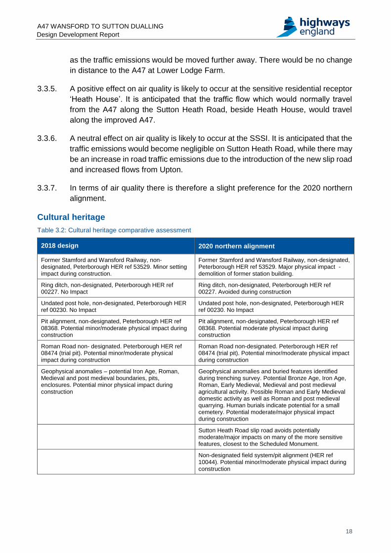
Cultural heritage
Table 3.2: Cultural heritage comparative assessment
2018 design 2020 northern alignment
Former Stamford and Wansford Railway, non-designated, Peterborough HER ref 53529. Minor setting impact during construction.
Former Stamford and Wansford Railway, non-designated, Peterborough HER ref 53529. Major physical impact - demolition of former station building.
Ring ditch, non-designated, Peterborough HER ref 00227. No Impact
Ring ditch, non-designated, Peterborough HER ref 00227. Avoided during construction
Undated post hole, non-designated, Peterborough HER ref 00230. No Impact
Undated post hole, non-designated, Peterborough HER ref 00230. No Impact
Pit alignment, non-designated, Peterborough HER ref 08368. Potential minor/moderate physical impact during construction
Pit alignment, non-designated, Peterborough HER ref 08368. Potential moderate physical impact during construction
Roman Road non- designated. Peterborough HER ref 08474 (trial pit). Potential minor/moderate physical impact during construction
Roman Road non-designated. Peterborough HER ref 08474 (trial pit). Potential minor/moderate physical impact during construction
Geophysical anomalies – potential Iron Age, Roman, Medieval and post medieval boundaries, pits, enclosures. Potential minor physical impact during construction
Geophysical anomalies and buried features identified during trenching survey. Potential Bronze Age, Iron Age, Roman, Early Medieval, Medieval and post medieval agricultural activity. Possible Roman and Early Medieval domestic activity as well as Roman and post medieval quarrying. Human burials indicate potential for a small cemetery. Potential moderate/major physical impact during construction
Sutton Heath Road slip road avoids potentially moderate/major impacts on many of the more sensitive features, closest to the Scheduled Monument.
Non-designated field system/pit alignment (HER ref 10044). Potential minor/moderate physical impact during construction
A47 WANSFORD TO SUTTON DUALLING Design Development Report
19
3.3.1. The 2020 northern alignment would result in the demolition of the former Wansford
Road railway station a non-designated (in national or local listing) building of local
historic value. Demolition of the building would not be required by the 2018 design.
3.3.2. The 2018 design used more of the existing road corridor, which would potentially
disturb the archaeological remains of the Roman road within the footprint of the
existing A47. The 2020 northern alignment has a greater potential to affect
possible remains of the Roman road within the adjacent agricultural land.
However, based on the results of geophysics, the likelihood of those remains
being found outside of the existing A47 corridor is low.
3.3.3. The 2020 northern alignment uses more open land than the 2018 design. There
is therefore a higher potential for affecting potential archaeological features (other
than the Roman Road) which have been identified through aerial and geophysical
survey. The features which have been archaeologically sampled have been
identified as Roman and Early Medieval date and therefore of up to medium value,
with a potential for remains to be of up to high value. Sampling in the area of the
2018 design has not identified a date for any potential features, suggesting the
area south of the existing A47 is less evidence-rich than the north. All effects could
be subject to suitable mitigation measures however, mitigation would take the form
of preservation by record, which is not regarded as a replacement for the feature
or justification for destruction.
3.3.4. The 2018 design is preferred for cultural heritage due to the reduced impact on
the former railway station and reduced likelihood of effects on buried
archaeological remains.
Landscape and visual
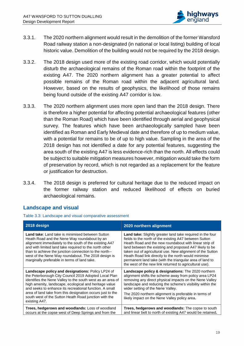
Table 3.3: Landscape and visual comparative assessment
2018 design 2020 northern alignment
Land take: Land take is minimised between Sutton
Heath Road and the Nene Way roundabout by an alignment immediately to the south of the existing A47 and with limited land take required to the north other than to achieve the junction connection to the north--west of the Nene Way roundabout. The 2018 design is marginally preferable in terms of land take.
Land take: Slightly greater land take required in the four
fields to the north of the existing A47 between Sutton Heath Road and the new roundabout with linear strip of land between the existing and proposed A47 likely to be taken out of agricultural use. New alignment of the Sutton Heath Road link directly to the north would minimise permanent land take (with the triangular area of land to the west of the new link returned to agricultural use).
Landscape policy and designations: Policy LP24 of
the Peterborough City Council 2019 Adopted Local Plan identifies the Nene Valley to the south west as an area of high amenity, landscape, ecological and heritage value and seeks to enhance its recreational function. A small area of land take from this designation occurs just to the south west of the Sutton Heath Road junction with the existing A47.
Landscape policy & designations: The 2020 northern
alignment shifts the scheme away from policy area LP24 removing any direct physical impacts on the Nene Valley landscape and reducing the scheme's visibility within the wider setting of the Nene Valley.
The 2020 northern alignment is preferable in terms of likely impact on the Nene Valley policy area.
Trees, hedgerows and woodlands: Loss of woodland
occurs at the copse west of Deep Springs and from the
Trees, hedgerows and woodlands: The copse to south and linear belt to north of existing A47 would be retained.
A47 WANSFORD TO SUTTON DUALLING Design Development Report
20
2018 design 2020 northern alignment
linear belt of trees to the north of the existing A47 to provide junction link to the Nene Way roundabout. Limited loss of hedgerows and individual trees from areas to the south of the A47. Overall the extent of tree and hedgerow removal likely to be broadly similar.
Neither design is preferable in terms of likely loss of woodland, trees and hedgerows of notable quality.
Additional loss of woodland cover would occur in the
vicinity of disused railway line to the south of Heath House. Loss of some short sections of several notable hedgerows which separate the four principal fields to the north of the existing A47 between Sutton Heath Road and the Nene Way roundabout. Overall extent of tree and hedgerow removal likely to be broadly similar.
Neither design is preferable in terms of likely loss of woodland, trees and hedgerows of notable quality.
Landscape character effect: Alignment of existing A47
broadly coincides with the boundary of the Nene Valley landscape character area to the south and south-west and the Nassaburgh Limestone Plateau to the north and north east. The existing design remains within the fringes of the Nene Valley (which is subject to various urbanising influences) and does not extend into the more open rural countryside of the Nassaburgh Limestone Plateau. Furthermore, the tree belt to the north of the existing A47 provides visual separation from the Nassaburgh Limestone Plateau landscape.
The existing design is marginally preferable in terms of likely effects on landscape character.
Landscape character effect: The 2020 northern
alignment extends to the north of the tree belt along the existing A47 into the visually open rural landscape of the Nassaburgh Limestone Plateau. The Sutton Heath Road link directly to the north would pass through an area of open countryside but its proposed route is consistent with the surrounding landscape pattern. The Peterborough Landscape Character Assessment of 2007 identifies this landscape area as being of better condition and strength of character compared to the Nene Valley. It remains the case, however, that the scheme would lie at the southern fringe of the character area and mitigation could be achieved through new planting and visual containment.
Visual effects: Visual receptors associated with the
section of route between Sutton Heath Road and the Nene Way roundabout are relatively few. Occasional glimpses would occur north and north-east from footpaths within the Nene Valley (including a locally named route) and from the northern fringes of the village of Sutton. The property known as Deep Springs would be removed.
Visual effects: There are relatively few visual receptors
within the open countryside of the Nassaburgh Limestone Plateau landscape to the north. Very limited visibility would be likely from footpaths and properties in the vicinity of Upton village to the north-east and Lower Lodge Farm to the east. Were it to be retained, the visual effect on Deep Springs would not be significant due to retention of the tree belt to its north. Old Station House associated with the disused railway would be removed.
Overall, the 2020 northern alignment would have less effect on visual amenity due to the general absence of visual receptors to the north and would be preferable.
3.3.5. In summary, the 2020 northern alignment would have a greater effect on
landscape character and value than the 2018 design but less effect on overall
visual amenity. This reflects the more sensitive landscape of the Nassaburgh
Limestone Plateau landscape located to the north and the presence of more
frequent visual receptors (settlement and footpaths) and policy areas to the south.
Overall and on balance, the 2018 design is considered marginally preferable to
the 2020 northern alignment in combined landscape and visual terms. However,
the new or increased landscape and visual effects of the 2020 northern alignment
would not be significant. Furthermore, it is noted that any landscape character
effect on the southernmost fringes of the Nassaburgh Limestone Plateau would
be limited and could be mitigated by appropriate planting and visual containment
to define and integrate the highway corridor and visually separate it from the open
rural landscape to the north.
3.3.6. In terms of the landscape and visual assessment, there is therefore a marginal
preference for the 2018 design, but any additional adverse effects of the 2020
northern alignment would be insignificant.
A47 WANSFORD TO SUTTON DUALLING Design Development Report
21
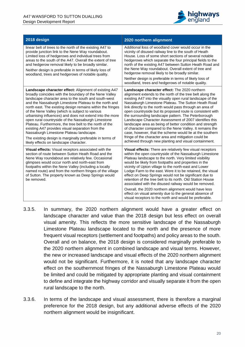
Biodiversity
Table 3.4: Biodiversity comparative assessment
2018 design 2020 northern alignment
The 2018 design is located further from the Sutton and Heath Bogs SSSI. Sutton Heath Road, adjacent to the SSSI will remain open for traffic travelling north. Indirect effects on the SSSI are anticipated to be similar to the 2020 northern alignment.
The alignment is closer to the SSSI. The proposed new Sutton Heath slip road will move traffic further from the majority of the SSSI. Indirect effects should be similar to the 2018 design.
Areas of the A47/A1 Interchange Road Verges North County Wildlife Site (CWS), the Sutton Meadows North CWS, and the Sutton Disused Railway CWS will be permanently lost. There will be greater effects and loss of the Sutton Disused Railway CWS due to the 2018 design having a greater crossing distance over the CWS.
Permanent loss of the areas of the A47/A1 Interchange Road Verges North CWS and Sutton Meadows North CWS will be marginally less than the 2018 design.
A greater section of the mature woodland to the east of the disused railway crossing will be lost.
More hedgerows will be severed by the slip road and a greater amount of mature tree line will be lost than in the 2018 design. However, the mature woodland area to the south-east of the disused railway crossing will be retained.
The extended distance between the existing railway crossing and the proposed new crossing to the south of Sutton Heath Road could have a greater effect on species including badgers and other small mammals by deterring them from crossing or increasing the risk of them being killed.
There will be also be a higher risk of mortality through collision with traffic for bats. The traffic on the new road is also predicted to be travelling at an increased speed, making it more difficult for individuals to evade oncoming traffic. `
The distance between the proposed new crossing is only slightly greater than the 2020 northern alignment.
Survey information to date has identified the potential for roosts in both the mature woodland to the south of Sutton Heath Woodland and the west, adjacent to Wittering Brooke.
The extended distance between the existing railway crossing and the proposed new crossing to the south of Sutton Heath Road could have a greater effect on species including badgers and other small mammals by deterring them from crossing or increasing the risk of them being killed.
There will be also be a higher risk of mortality through collision with traffic for bats. The traffic on the new road is also predicted to be travelling at an increased speed, making it more difficult for individuals to evade oncoming traffic.
The distance between the proposed new crossing is only slightly lesser than the 2018 design.
Survey information to date has identified the potential for roosts in both the mature woodland to the south of Sutton Heath Woodland and the west, adjacent to Wittering Brooke.
3.3.7. Emissions of nitrogen oxides (NOx) from road traffic are known to make a
contribution to nitrogen deposition to sensitive habitats. As part of the 2018 design,
Sutton Heath Road adjacent to the SSSI would remain open to traffic. As part of
the 2020 northern alignment, traffic would connect onto the new slip road from
Sutton Heath / Langley Bush road junction to connect to the new A47. Traffic
would be moved further from the SSSI as a result of the new slip road before
connecting into the Sutton Heath / Langley Bush road junction.
3.3.8. As a result of the 2020 northern alignment, it is anticipated that the traffic
emissions would become negligible on Sutton Heath Road south of the junction,
while there may be an increase in road traffic emissions due to the introduction of
the new slip road and increased flows from Upton (as a result of the closure to
Nene Way roundabout).
A47 WANSFORD TO SUTTON DUALLING Design Development Report
22
3.3.9. The loss of County Wildlife Site is marginally greater for the 2018 design. Overall,
the extent of tree and hedgerow removal is likely to be broadly similar. The 2018
design however severs the group of mature trees to the west of Deep Springs and
east of the disused railway. These mature trees are protected by a Tree
Preservation Order (TPO). Ecological surveys have identified this area as a key
habitat for protected species.
3.3.10. Survey data was collected in 2017 and 2020 and at the time of writing this report
some surveys are still ongoing. Based on the existing data, badgers, bats and
other small mammals are in the vicinity of the eastern extent of the proposed
scheme. The effects of the proposed scheme on protected species is broadly
similar for both the 2018 and 2020 designs.
3.3.11. As such, there is a marginal preference for the 2020 northern alignment.
Noise and vibration
Table 3.5: Noise and vibration comparative assessment
2018 design 2020 northern alignment
Scheme approximately 280m from noise sensitive
receptor (NSR) at Willowhayne House, The Drift, the
ponds to the south-west and the village of Sutton to the
south.
Dual carriageway approximately 340m from same
receptors.
The 2020 northern alignment is further from the same
receptors. It is therefore likely to result in lower noise levels
at these receptors than would have occurred for the 2018
design.
Deep Springs, Leicester Road, Sutton was to be
demolished and therefore effects would not have been
considered at this location.
The dual carriageway would be located further to the north,
meaning the receptor does not necessarily require
demolition. The proposed dual carriageway location is
approximately 72m further to the north than the existing
A47 carriageway and therefore significant effects should be
avoided at this receptor.
Northern connection to Sutton Heath Road was curved
round adjacent to the dual carriageway.
The 2020 northern alignment includes a link to Sutton
Heath Road further to the north, adjacent to the junction
with Langley Bush Road. This is not likely to result in a
significant difference in the predicted noise levels.
2018 design approximately 45m from the NSR, Old
Station House on Sutton Heath Road (this receptor is in
a Noise Important Area (NIA). The Cottage and Heath
House, to the north of Old Station House were
approximately 70m and 140m from the 2018 design.
The proposed dual carriageway is located further to the
north. Old Station House will be demolished and therefore
will no longer be a receptor (this is the only receptor within
NIA 5304). The proposed dual carriageway is nearer to
The Cottage and Heath House and therefore noise levels
are likely to increase at these receptors.
The 2018 design connected the existing Sutton Heath
Road to the Nene Way roundabout. The existing Sutton
Heath Road is adjacent to an SSSI. Minor increases in
traffic flows on Sutton Heath Road would result in
increased noise levels at the SSSI.
With the 2020 northern alignment, a new proposed slip
road connects the A47 junction to Southorpe and Upton.
This would decrease the traffic noise levels currently
emitted by the existing Sutton Heath Road, but result in
slightly higher numbers of vehicles using the new slip road.
The new slip road is however typically further from the
SSSI than the existing Sutton Heath Road.
A47 WANSFORD TO SUTTON DUALLING Design Development Report
23
2018 design 2020 northern alignment
Based on this combination of factors, it is likely that the
southern areas of the SSSI, near to the existing Sutton
Heath Road would benefit more from the 2020 northern
alignment, but the northern areas of the SSSI would benefit
more from the 2018 design.
3.3.12. The receptors discussed above have been chosen as a sample to best represent
those that are likely to experience differences in noise level when comparing the
two designs.
3.3.13. When comparing the 2020 northern alignment with the 2018 design, it is likely that
the receptors on Sutton Heath Road, The Cottage and Heath House, will
experience an increase in noise levels. However, a large number of receptors to
the south of the existing A47, situated in the village of Sutton are anticipated to
experience a slight reduction in noise levels.
3.3.14. When comparing the likely noise effects at the SSSI adjacent to Sutton Heath
Road, both designs are likely to result in increased noise levels at this location
depending on the mitigation measures which are to be designed. The 2018 design
is likely to increase noise levels more at the southern SSSI areas, and the 2020
northern alignment is likely to increase levels more at the northern SSSI areas.
When considered as a whole, the noise difference between the two designs at the
SSSI is likely to be minor.
3.3.15. Therefore, it is likely that the 2020 northern alignment will be more beneficial, in
terms of noise, when compared with the 2018 design. This is primarily due to the
carriageway in the 2020 northern alignment being further from a relatively large
number of NSRs in the village of Sutton.
Walkers, cyclists and horse-riders
Table 3.6: Walkers, cyclists and horse-riders comparative assessment
2018 design 2020 northern alignment
The 2018 design retains the Nene Way roundabout at Sutton. The roads to the north and south of the roundabout and existing A47 form part of an advisory cycle route, as indicated on the Peterborough Rural Cycle Network Map. Walking cycling and horse-riding (WCHR) surveys recorded significant north to south cycle movements across the Nene Way roundabout.
Removal of the Nene Way roundabout would sever the advisory cycle route. However, cyclists would be able to follow an alternative safer route.
To facilitate safe north to south crossings of the new A47 by pedestrians and cyclists and to also maintain the advisory cycle route between Sutton and Upton, a new connection will be provided between the proposed shared footway and cycleway on the south side of the A47 and Sutton Heath Road, which will be downgraded to an access road as part of the proposed scheme. The new connection will make use of a ramp arrangement and the disused railway to provide a grade separated crossing of the new A47.
A47 WANSFORD TO SUTTON DUALLING Design Development Report
24
3.3.16. The 2018 design maintains accessibility between the communities of Upton and
Sutton via the upgraded Nene Way roundabout. In terms of cyclists, the road to
the north and south of the Nene Way roundabout is an advisory cycle route. This
roundabout would be removed as part of the 2020 northern alignment and walkers
and cyclists would be expected to follow a new route.
3.3.17. The new route would include making use of the existing Langley Bush Road, the
proposed downgraded Sutton Heath Road and underpass and the proposed
shared footway and cycleway to be provided on the south side of the new A47.
This alternative route is anticipated to lead to a modest increase to journey times
in comparison with the 2018 design but will provide a grade separated crossing of
the new A47 for walkers and cyclists.
3.3.18. The grade separated crossing of the new A47, included as part of the 2020
northern alignment, would be considered safer than cyclists and walkers crossing
at the upgraded existing Nene Way roundabout.
Road drainage and the water environment
Table 3.7: Road drainage and the water environment comparative assessment
2018 design 2020 northern alignment
Within Flood Zone 1 (low risk of fluvial flooding) apart from one area west of the culvert at Sutton Heath Road which is Flood Zone 3 – compensatory storage will be required here.
Within Flood Zone 1 (low risk of fluvial flooding) apart from one area west of the culvert at Sutton Heath road which is Flood Zone 3 – compensatory storage will be required here, though there is less floodplain than with the 2018 design.
Potential cycle link possibly at risk of flooding (Flood Zone 3) depending on level of cycleway.
Risk to one area west of the culvert at Sutton Heath Road from flooding should an upstream reservoir dam fail or be breached. This would be considered a low risk probability event.
As per the 2018 design.
Majority of the eastern section is very low risk of surface water flooding but there is one instance of low to high flood risk - a potential flood flow pathway crossing the scheme (between the culvert and Sutton Heath Road).
Majority of this section is at very low risk of surface water flooding but there are instances of low to high flood risk, including potential flood flow pathways crossing the scheme (at two locations – between the culvert and Sutton Heath Road, and near one of the field drains to the east) and ponding at two locations (Nene Way roundabout and near the culvert).
Route covers a field drain, which runs adjacent to existing carriageway, and a pond fed by the field drain.
Route crosses two field drains.
Entire mainline route is underlain by river terrace deposits (secondary A aquifer), with a groundwater vulnerability of medium to high.
The eastbound slip road to the eastern junction (connecting to ‘The Drift’ and Sutton village) crosses a very small area to the north of the river terrace deposits extents, where the Rutland Formation (secondary B aquifer) is exposed at surface.
The 2020 northern alignment remains within the extents of the river terrace deposits (secondary A aquifer; groundwater vulnerability of medium to high).
The proposed Sutton Heath Road slip road to the proposed new roundabout passes over an area where the Blisworth Limestone Formation (principal aquifer) is exposed at surface. This area has a greater groundwater vulnerability (high), and therefore there is a greater risk of water quality impacts to the principal aquifer.

A47 WANSFORD TO SUTTON DUALLING Design Development Report
25
3.3.19. The main difference between the 2018 design and the 2020 northern alignment is
the crossing of two field drains and an increase in surface water flood risk, which
may require additional culverting to maintain drainage pathways. Although
compensatory storage is required at Sutton Heath Road for both options, there is
less compensatory storage required for the 2020 northern alignment.
Furthermore, the new Sutton Heath Road slip road to the proposed new
roundabout passes over an area of greater groundwater vulnerability. Due to this,
there is a slight preference for the 2018 design.
Climate
Table 3.8: Climate comparative assessment
2018 design 2020 northern alignment
The Scoping Report identified carbon emissions resulting from the construction of the project. The use of construction materials were identified as the main potential contributor to climate change, with additional greenhouse gas emissions arising from the use of plant and transport of materials.
It is anticipated that the 2020 northern alignment will result in a reduction in earthworks and greater use of existing infrastructure. Carbon emissions through the construction phase of the project are likely to be lesser than with the 2018 disign
The Scoping Report identified potential for increased carbon emissions through the operational phase of the project (due to changes in traffic flow and speed limits).
As per the 2018 design
3.3.20. Based on the reduced earthworks and greater use of existing infrastructure
resulting in reduced carbon emissions, the preference is for the 2020 northern
alignment.
Comparison of options
3.3.21. Air quality, biodiversity, noise and vibration and climate expressed a marginal
preference for the 2020 northern alignment.
3.3.22. For air quality there is a slight preference for the 2020 northern alignment due to
some positive effects. For biodiversity there is a marginal preference for the 2020
northern alignment as a group of mature trees would be retained and there would
be marginally less land-take from the County Wildlife Site.
3.3.23. In terms of noise and vibration the carriageway would be further from a relatively
large number of receptors in the village of Sutton. Based on the reduced
earthworks and greater use of existing infrastructure resulting in reduced carbon
emissions, the preference was for the 2020 northern alignment.
3.3.24. Cultural heritage, landscape and visual, accessibility and road drainage and the
water environment expressed a slight preference for the 2018 design.
3.3.25. For cultural heritage the 2018 design was preferred due to the reduced impact on
the former railway station and reduced likelihood of effects on buried
A47 WANSFORD TO SUTTON DUALLING Design Development Report
26
archaeological remains. The 2020 northern alignment has a higher potential for
affecting potential archaeological assets.
3.3.26. In terms of the landscape and visual assessment, there is a marginal preference
for the 2018 design, but any additional adverse effects of the 2020 northern
alignment would be insignificant.
3.3.27. The 2018 design maintains accessibility between the communities of Upton and
Sutton via the Nene Way roundabout. Walkers and cyclists would also experience
a modest increase journey times with the 2020 northern alignment. However the
proposal for a grade separated crossing under the A47 is considered safer than
cyclists and walkers crossing at a roundabout.
3.3.28. For road drainage and the water environment the preference is for the 2018 design
due to the crossing of two field drains and an increase in surface water flood risk,
which may require additional culverting to maintain drainage pathways with the
2020 northern alignment.
3.3.29. For all the topics assessed the 2018 design and the 2020 northern alignment
perform similarly. The outcome of the assessments suggested that the 2020
northern alignment performs marginally better. The 2020 northern alignment does
not increase significant environmental effects on wildlife, air quality, noise and
vibration and accessibility for walkers and cyclists.
Traffic assessment
3.4.1. There are minimal differences in the traffic assessment between the 2018 design
and the 2020 northern alignment, east of the Scheduled Monument.
3.4.2. Traffic is not therefore a differentiating factor between the two designs.
Costs
3.5.1. In terms of scheme costs, the estimate for the Wansford to Sutton scheme is
between approximately £50-100 million. It is anticipated that the 2018 design and
the 2020 design can be delivered within the same budget.
3.5.2. Cost is not therefore a differentiating factor between the two designs.
A47 WANSFORD TO SUTTON DUALLING Design Development Report
27
Outcome
3.6.1. As set out in Section 1.3 following the feedback to the statutory consultation in
2018, it was noted that many stakeholders would prefer the route to be aligned
north of the existing A47.
3.6.2. The 2020 northern alignment responds to the public and stakeholder feedback by
providing a more northerly alignment for the improvements to the A47 to the east
of the Scheduled Monument.
3.6.3. Both the 2018 design and the 2020 northern alignment have been designed to
meet the appropriate standards and there is therefore no preference for either
option.
3.6.4. The 2018 design and the 2020 northern alignment perform similarly in terms of
the environmental topics assessed. The outcome of the assessments suggested
that the 2020 northern alignment performs marginally better.
3.6.5. Traffic and cost were not differentiating factors between the two designs
3.6.6. Taking into account the feedback to the 2018 statutory consultation and the
outcome of the comparative assessment the 2020 northern alignment has
therefore been taken forward for further detailed design.

A47 WANSFORD TO SUTTON DUALLING Design Development Report
28
4. Conclusion
4.1.1. The purpose of this report is to inform the public and stakeholders of the specific
changes made to the 2018 design in response to feedback to the statutory
consultation and ongoing design development.
4.1.2. The report also includes a comparative assessment of the 2018 design and the
2020 northern alignment proposed to the east of the Scheduled Monument.
4.1.3. Taking into account the feedback to the 2018 statutory consultation and the
outcome of the comparative assessment the 2020 northern alignment has been
taken forward.
4.1.4. Further consultation and engagement is being undertaken to gather feedback on
the revised proposals from stakeholders and members of the public.
4.1.5. The feedback on the 2020 design will be considered prior to the submission of an
application for a Development Consent Order.
A47 WANSFORD TO SUTTON DUALLING Design Development Report
29
APPENDIX A – 2020 DESIGN SCHEME LAYOUT
1
2
6
.8
m
7
A
6
1
1
8
B
e
d
f
o
r
d
S
u
rg
e
ry
3
O
L
D
L
E
IC
E
S
T
E
R
R
O
A
D
SP
IN
NE
Y
2
P
p
H
o
Track
1
R
I
V
E
R
S
I
D
E
E
l S
u
b
S
ta
(C
of E
)
1
1
.3
m
1
2
2
9
.0
m
7
T
H
A
C
K
E
R
S
C
L
O
S
E
32
T
C
B
1
7
.8
m
L
i
o
n
C
o
t
t
N
E
N
E
C
L
O
S
E
6
2
1
1
2
5
1
C
a
t
t
le
G
r
id
H
o
te
l
8
1
7
2
2
1
3
1
W
h
ite
2
1
1
9
.1
m
T
h
e
M
o
o
r
in
g
s
6
1
3
M
P
4
7
P
p
4
9
P
a
v
ilio
n
1
1
2
6
1
4
2
9
.9
m
2
8
1
0
3
7
1
9
BLACK SWAN SPINNEY
2
2
R
iv
e
r
m
e
a
d
3
3
1
H
o
u
s
e
T
h
e
1
T
C
B
1
3
1
5
1
9
.5
m
18
P
ie
r H
e
a
d
4
3
Drain
1
9
2
2
8
2
0
3
F
a
ir
fa
x
T
h
e
S
ta
b
le
s
H
a
y
c
o
c
k
F
ilte
r
T
a
n
k
H
o
llo
w
2
9
7
R
i
v
e
r
N
e
n
e
H
o
u
s
e
1
3
B
la
c
k
S
w
a
n
H
ill
1
4
.0
m
1
1
1
T
h
e
R
O
B
IN
S
W
O
O
D
1
9
.8
m
P
C
1
7
a
A 1
2
S
a
c
r
e
w
e
ll F
a
r
m
O
L
D
N
O
R
T
H
R
O
A
D
P
E
T
E
R
B
O
R
O
U
G
H
R
O
A
D
4
T
e
m
p
la
r
1
7
1
5
8
B
R
I
D
G
E
E
N
D
7
L
B
1
4
3
4
.1
m
LONDON ROAD
1
4
P
u
m
p
1
5
.5
m
K
i
n
g
f
i
s
h
e
r
H
o
2
5
4
W
a
te
r
T
e
l E
x
A
n
c
h
o
r
C
o
t
t
5
1
6
1
1
A
1
R
iv
e
rs
id
e
S
W
A
N
H
IL
L
3
0
1
9
.8
m
S
t M
a
ry's
C
h
u
rch
1
4
.6
m
2
4
1
8
.0
m
H
a
ll
W
a
n
s
fo
r
d
1
3
2
7
1
1
U
n
d
e
r
p
a
s
s
6
E
l S
u
b
S
ta
P
a
t
h
(
u
m
)
40
W
a
n
s
fo
r
d
B
r
id
g
e
4
1
2
3
2
7
1
4
B
a
n
k
H
o
u
s
e
S
h
e
lte
r
H
o
u
s
e
T
h
e
F
i
r
s
T
ra
ck
R
O
B
IN
S
F
IE
L
D
1
7
1
8
4
1
3
A
1
8
C
e
d
a
r H
o
u
s
e
5
S
u
b
w
a
y
2
2
a
2
1
a
2
1
3
2
3
1
9
a
1
A
1
B
F
B
P
a
th
(u
m
)
8
1
0
1
6
a
1
6
1
0
B
a
rn
a
b
y
H
o
u
s
e
T
h
e
F
o
rg
e
6
4
S
S
C
R
E
E
R
a
n
d
C
o
C
o
n
s
t
B
d
y
C
S
U
A
B
d
y
U
A
B
d
y
B
S
E
E
R
a
n
d
C
o
C
o
n
s
t
B
d
y
1
7
A
8
1
4
.9
m
P
o
s
t
1
7
.0
m
S
ta
tio
n
M
a
s
t
W
a
te
r
W
a
te
r
W
a
te
r
T
r
a
c
k
T
r
a
c
k
Dra
in
Is
s
u
e
s
P
u
m
p
in
g F
illin
g
S
ta
tio
n
L
a
n
d
in
g
S
ta
g
e
R
i
v
e
r
N
e
n
e
1
9
.9
m
D
r
a
i
n
Is
s
u
e
s
1
7
.8
m
W
a
te
r
1
1
.8
m
A
4
7
9
.3
m
1
7
.3
m
E
l S
u
b
S
ta
S
lu
ic
e
D
ra
in
P
o
n
d
D
r
a
i
n
1
7
.1
m
2
2
.8
m
F
lo
o
d
G
a
u
g
in
g
T
r
a
c
k
D
r
a
i
n
P
o
n
d
D
r
a
i
n
C
a
ttle
G
r
id
H
o
u
s
e
H
e
a
th
T
h
e
B
u
n
g
a
lo
w
W
a
te
r
S
ta
tio
n
1
9
.5
m
D
r
a
i
n
M
S
SU
TT
ON
H
EA
TH
R
OA
D
CS
UA Bdy
C
S
CS
CR
Def
D
e
f
1
.2
2
m
R
H
Def
D
r
a
i
n
2
0
.1
m
W
illo
w
h
a
y
n
e
D
ra
in
M
S
D
ra
in
2
1
.4
m
T
H
E
D
R
IF
T
A
4
7
P
o
n
d
R
iv
e
r N
e
n
e
L
B
H
o
u
s
e
D
e
e
p
S
p
rin
g
s
D
is
m
a
n
tle
d
R
a
ilw
a
y
2
5
.7
m
2
2
.1
m
R
O
M
A
N
R
O
A
D
T
ra
c
k
UA
B
dy
CR
E
T
L
2
0
.7
m
N
E
N
E
W
A
Y
S
h
e
lte
r
1
5
.4
m
1
4
.8
m
R
O
M
A
N
R
O
A
D
(
c
o
u
r
s
e
o
f
)
L
o
w
e
r L
o
d
g
e
F
a
rm
A
4
7
E
r
m
in
e
S
t
r
e
e
t
1
9
.3
m
R
O
M
A
N
R
O
A
D
E
r
m
in
e
S
t
r
e
e
t
D
r
a
in
P
o
n
d
T
r
a
c
k
D
e
f
1
.
2
2
m
R
H
1
.
2
2
m
R
H
F
W
D
e
f
1
.
2
2
m
R
H
D
e
f
O
L
D
N
O
R
T
H
R
O
A
D
F
B
(s
ite
o
f)
W
INDG
ATE W
AY
2
2
3
.5
m
T
h
e
O
ld
R
e
c
to
r
y
P
o
n
d
3
6
.0
m
S
e
y
m
a
rk
H
o
u
s
e
A 1
C
o
p
p
e
rfie
ld
H
o
u
s
e
s
6
3
C
o
u
n
c
il
R
O
M
A
N
B
U
IL
D
IN
G
M
ill H
o
u
s
e
2
4
2
4
.1
m
C
a
ttle
G
r
id
12
6
1
F
B
Lay-by
T
a
n
k
P
o
n
d
M
a
s
t (
T
e
le
c
o
m
m
u
n
ic
a
tio
n
)
S
a
c
re
w
e
ll F
a
rma
n
d
C
o
u
n
tr
y
C
e
n
tr
e
C
S
C
S
1
.
2
2
m
R
H
De
f
R
H
C
S
W
in
d
g
a
te
W
a
y
P
o
n
d
P
a
th
T
r
a
c
k
P
o
n
d
P
o
n
d
(
c
o
u
r
s
e
o
f
)
R
O
M
A
N
R
O
A
D
D
r
a
i
n
4
7
.1
m
H
e
ll
C
o
rn
e
r
G
P
T
ra
c
k
T
o
p
F
ie
ld
S
p
in
n
e
y
4
3
.6
m
S
U
T
T
O
N
H
E
A
T
H
R
O
A
D
1
.2
2
m
R
H
1
.
2
2
m
R
H
D
e
f
1.22m RH
1
.
2
2
m
R
H
U
n
d
T
r
a
c
k
D
r
a
i
n
D
ra
in
D
r
a
in
P
o
n
d
J
u
b
ile
e
C
S
1.2
2m
R
H
F
B
W
A
N
S
F
O
R
D
N
E
N
E
W
A
Y
D
r
a
i
n
P
p
1
4
3
R
iv
e
r
N
e
n
e
P
o
n
d
1
3
S
tib
b
in
g
to
n
1
3
7
1
3
.7
m
P
o
n
d
O
L
D
G
R
E
A
T
N
O
R
T
H
R
O
A
D
2
4
3
5
9
a
S
tib
b
in
g
to
n
H
a
ll
S
u
b
T
C
B
3
3
1
1
R
O
M
A
N
P
O
T
T
E
R
Y
K
IL
N
S
P
a
t
h
C
H
U
R
C
H
L
A
N
E
C
H
U
R
C
H
L
A
N
E
(
s
ite
s
o
f)
E
l
9
G
r
a
v
e
Y
a
r
d
P
u
m
p
s
L
B
S
tib
b
in
g
to
n
S
tib
b
in
g
to
n
F
illin
g
S
ta
tio
n
T
r
a
c
k
C
a
s
tle
F
a
rm
C
o
tta
g
e
W
e
ll
W
o
o
d
la
n
d
s
A
1
1
5
a
N
e
n
e
H
o
u
s
e
1
0
3
1
9
.5
m
C
o
u
rt
1
1
3
2
8
1
t
o
1
5
1
3
1
5
F
o
o
t
1
1
.3
m
2
4
.4
m
Sluice
22
1
1
7
.4
m
C
ro
ss K
e
ys (P
H
)
3
1
8
10
6
S
lu
ic
e
B
r
id
g
e
2
7
59
69
Sluice
26
L
B
2
6
.5
m
2
8
36
D
r
a
in
P
O
Yew Tree Cott
G
a
rd
e
n
s
S
to
n
e
a
c
re
1
5
.5
m
(
T
r
a
c
k
)
E
r
m
in
e
S
t
r
e
e
t
1
4
.0
m
R
O
M
A
N
R
O
A
D
S
U
T
T
O
N
C
R
O
S
S
W
A
Y
S
C
o
u
rt
T
e
n
n
is
T
h
o
r
n
h
a
u
g
h
13
Track
OLD
R
EC
TO
RY
D
R
3
0
.5
m
1
4
0
.8
m
L
B
C
o
tta
g
e
s
A
b
b
o
tt's
Th
e
Bungalow
S
a
c
r
e
w
e
ll L
o
d
g
e
2
7
.9
m
53
2
2
1
.8
m
6
5
C
a
ttle
G
r
id
Lay-by
D
e
f
Def
D
e
f
1
.2
2
m
CS
C
G
P
a
t
h
(
u
m
)
C
G
F
B
B
a
rn
C
o
tta
g
e
F
B
T
r
a
c
k
D
r
a
in
T
r
a
c
k
D
r
a
i
n
P
o
n
d
s
4
0
.6
m
E
r
m
in
e
S
tr
e
e
t
G
P
1
.
2
2
m
R
H
U
n
d
D
e
f
D
e
f
S
p
in
n
e
y
D
is
m
a
n
tle
d
R
a
ilw
a
y
Is
s
u
e
s
Is
s
u
e
s
SU
TT
ON
H
EA
TH
R
OA
D
V
is
ito
r
C
e
n
tr
e
P
o
n
d
D
ef
CS
D
e
f
W
a
r
d
B
d
y
C
S
C
S
D
e
f
D
e
f
T
r
a
c
k
T
ra
ck
T
r
a
c
k
T
r
a
c
k
C
G
C
o
lle
c
ts
C
o
lle
c
ts
F
B
T
H
E
D
R
I
F
T
S
U
T
T
O
N
H
E
A
T
H
R
O
A
D
4
2
.0
m
4
8
.9
m
P
o
n
d
S
p
r
in
g
1
6
.1
m
P
p
M
a
n
o
r
F
a
r
m
1
T
C
B
4
S
u
tto
n
H
a
lf A
c
re
P
o
n
d
4
1
1
5
.2
m
P
p
1
1
8
H
o
u
s
e
C
h
u
rc
h
45
G
r
a
v
e
Y
a
r
d
D
ra
in
L
O
V
E
R
S
L
A
N
E
D
ra
in
L
B
1
6
.6
m
2
S
t M
ic
h
a
e
l's
C
h
u
c
h
1
2
P
o
n
d
Drain
1
1
8
1
4
7
N
e
w
C
o
tta
g
e
M
a
tth
ia
s
C
H
U
R
C
H
L
A
N
E
T
h
e
G
ra
n
g
e
H
o
m
e
fie
ld
s
T
ra
c
k
5
7
Drain
4
4
a
M
AN
O
R
R
O
AD
2
2
B
o
a
t H
o
u
s
e
1
8
.3
m
(C
o
f E
)
5
1
9
.2
m
S
t J
o
h
n
th
e
B
a
p
tis
t's
P
a
t
h
(
u
m
)
D
r
a
i
n
P
o
n
d
B
a
rn
Dra
in
Drain
10
2
0
El Tfmr
4
3
9
P
o
n
d
1
7
.0
m
N
E
N
E
W
A
Y
1
5
.9
m
D
r
a
i
n
C
h
u
rc
h
L
e
e
W
y
n
d
ru
s
h
e
C
R
U
A
B
d
y
1
7
a
2
2
3
1
5
b
2
0
1
1
.3
m
2
7
D
r
a
i
n
1
F
ie
ld
S
tu
d
ie
s
C
e
n
tr
e
3
2
3
6
2
6
M
P
S
t
a
T
e
n
n
is
5
R
o
o
k
H
o
u
s
e
D
rain
4
W
e
ll
C
H
U
R
C
H
L
A
N
E
2
T
r
a
c
k
M
a
n
o
r
R
O
M
A
N
D
R
I
V
E
1
3
S
h
e
lte
r
1
7
A
1
2
a
2
4
.4
m
1
4
a
P
aperm
ills
B
a
r
n
s
id
e
H
o
u
s
e
D
ra
in
16
R
i
v
e
r
N
e
n
e
S
h
ip
E
n
d
H
o
u
s
e
O
ld
C
o
a
c
h
H
o
u
s
e
55
H
o
u
s
e
1
4
H
a
ll
S
tib
b
in
g
to
n
28
1
0
T
h
e
6
3
1
9
D
r
a
i
n
33
2
4
H
o
u
s
e
E
l S
u
b
S
ta
4
M
ill
6
7
15
12
C
H
A
P
E
L
C
T
7
2
0
21
3
13
C
o
u
rt
17
24
6
1
ELT
O
N
R
O
AD
9
R
iv
e
r
N
e
n
e
25
S
lu
ic
e
8
(PH)
B
6
7
1
A
llo
tm
e
n
t
1
8
.0
m
11
1
2
.8
m
W
e
ir
40
B
u
n
k
e
r
s
H
ill
T
r
a
c
k
5
65
2
3
S
lu
ic
e
B
o
a
t
M
a
r
s
to
n
e
T
e
n
n
is
L
o
c
k
E
E
R
&
C
o
C
o
n
s
t
B
d
y
C
R
C
O
C
R
1
.
2
2
m
R
H
S
t M
e
d
a
rd
s
H
o
Elberry H
ouse
O
rc
h
a
rd
T
h
a
tc
h
C
rayside
T
h
e
S
h
ie
lin
g
1
1
7
S
t A
n
d
re
w
's
C
h
u
rc
h
6
2
8
3
1
.4
m
S
h
e
p
h
e
rd
s
C
o
tta
g
e
9
5
T
h
e
O
ld
O
rc
h
a
rd
1
.2
2
m
R
H
SUTTON HEATH ROAD
SACREWELL FARM AND
COUNTRY CENTRE
A1
WANSFORD
SUTTON
PROPOSED FREE FLOW
LINK FROM A1 TO A47
PROPOSED NEW LINK
TO SACREWELL FARM
PROPOSED NEW
ROUNDABOUT LOCATION
PROPOSED UNDERBRIDGE
PROPOSED DUAL CARRIAGEWAY
NORTH OF EXISTING A47
ACCESS CLOSED
PROPOSED NEW LINK
PROPOSED SEGREGATED LEFT TURN
LANE FROM A1 TO A47 EASTBOUND
EXISTING BRIDGE
TO BE RETAINED
S
U
T
T
O
N
H
E
A
T
H
R
O
A
D
EXISTING NENE WAY ROUNDABOUT
TO BE RELOCATED
N
E
N
E
W
A
Y
T
H
E
D
R
IF
T
R
IV
E
R
N
E
N
E
BP FILLING STATION
A47 EXISTING CARRIAGEWAY USED AS
SHARED CYCLE/FOOTWAY ROUTE
SCHEDULED MONUMENT
NEW WALKING AND
CYCLING ROUTE
PROPOSED ALTERNATIVE ACCESS
TO GREAT NORTH ROAD HOUSES
PROPOSED NEW LINK
PASSING PLACES O
N UPTON DRIFT TO
BE CONFIRM
ED
CLOSURE OF ACCESS TO
A1 BEING CONSIDERED
ENLARGED
ROUNDABOUT
PROPOSED DUAL CARRIAGEWAY
WALKING AND
CYCLING
UNDERPASS
ACCESS CLOSED TO VEHICLES
BUS STOP CLOSED
EXISTING LAY BY REMOVED
U
P
T
O
N
D
R
I
F
T
R
O
A
D
HEATH HOUSE
S
U
T
T
O
N
H
E
A
T
H
R
O
A
D
L
A
N
G
L
E
Y
B
U
S
H
R
O
A
D
D
r
a
i
n
4
7
.1
m
H
e
ll
C
o
rn
e
r
1
.
2
2
m
R
H
U
n
d
D
r
a
i
n
T
a
n
k
s
3
7
.4
m
3
7
.7
m
CHURCH WALK
4
9
7
G
P
41
3
9
.3
m
T
ra
c
k
C
a
ttle
G
rid
G
P
P
a
t
h
(
u
m
)
4
2
.0
m
17
L
B
M
o
d
e
l F
a
rm
4
8
.9
m
D
r
a
i
n
4
0
.7
m
3
6
.7
m
3
4
.2
m
3
7
.8
m
T
C
B
D
r
a
i
n
4
7
.9
m
(T
ra
c
k
)
E
T
L
H
a
ll
U
p
to
n
G
le
b
e
H
o
u
s
e
21
31
B
L
IN
D
L
A
N
E
PASSING PLACES ON UPTON DRIFT TO BE CONFIRMED
U
P
T
O
N
D
R
I
F
T
R
O
A
D
NOTES
CLIENT
DRAWING TITLE
PROJECT TITLE
KEY TO SYMBOLS
REV DATE REVISION NOTE ORG CHK'D APP'D
This drawing should not be relied on or used in circumstances other than those for which it was originally prepared and for which Sweco UK Ltd was commissioned. Sweco UK Ltd accepts no responsibility for this drawing to any party other than the person by whom it was commissioned. This drawing has been prepared on behalf of Galliford Try by Sweco UK Ltd for the titled project or named part thereof and should not be relied upon or used for any other project without an independent check being carried out as to its suitability and prior written authority of Galliford Try being obtained.
Sweco UK Ltd accepts no responsibility or liability for the consequences of this drawing being used for a purpose other than the purposes for which it was commissioned. Any person using or relying on this drawing for such other purpose agrees, and will by such use or reliance be taken to confirm his/her agreement, to indemnify Sweco UK Ltd for all loss or damage resulting therefrom.
DESIGNER
CONTRACTOR
PROJECT STAGE
SHEET SIZE
DRAWING NUMBER
SCALE
SUITABILITY
STATUS REVISION
© Crown copyright and database rights 2020 Ordnance Survey
100030649. Use of this data is subject to terms and conditions.
A47 WANSFORD TO SUTTON DUALLING
HE551494-GTY-HGN-000-DR-CH-30006
P01 02/10/20 FIRST ISSUE AW EA SCM
A1 1:5000 S0 P02
WORK IN PROGRESS
2020 DESIGN
SCHEME LAYOUT
PCF STAGE 3
1:5000
0 500m250m
SITE OF SPECIAL SCIENTIFIC INTEREST
WATERCOURSE
BALANCING POND
1:5000
0 500m250m
PROPOSED DCO BOUNDARY
INFILTRATION BASIN
ON-ROAD NMU ROUTE
BRIDLEWAY
SHARED CYCLE / FOOTWAY (MAIN ROUTE)
SHARED CYCLE / FOOTWAY (DESIGNATED FUNDS SCHEME)
COUNTY WILDLIFE
SITE
TREE PRESERVATION
ORDER
NEW / IMPROVED VERGE
NEW / IMPROVED CARRIAGEWAY
P02 08/10/20 FOR CONSULTATION AW EA SCM