Embed Size (px)
Citation preview

7/23/07 -1-
A WATER PLAN FOR THE 21ST CENTURY:
REGIONAL SELF-SUFFICIENCY SCENARIO
INTRODUCTION
As the population of California continues to grow, the imbalance intensifies
between the demands for water supplies in the primarily arid regions growing the
fastest and the regions where water supplies originate, whose needs for their local
supplies also grow. Sooner or later California must unshackle itself from
dependence upon transfers of water from North to South, especially during
periods of least supply (dry years) when water presently exported is often not
surplus to the needs in the north, and develop regional self sufficiency. The
Sacramento-San Joaquin Delta is at the bottom of all the river systems of the
Central Valley of California and is currently experiencing a meltdown of its
ecosystem, largely as a result of the over commitment of the water resources,
especially during drier years, which would naturally, and normally, flow through it
on their way through Suisun, San Pablo, and San Francisco Bays. Failure to reverse
this trend will soon lead to extirpation of important aquatic species, some of which
are already listed under the Endangered Species Act; further reductions will surely
lead to wholesale destruction of one of the most important agricultural and
environmental areas in the world and eventually to loss of infrastructure which
supports the economy of the Western United States.
Proposals to build Peripheral Canals do not address the need to find better
ways to balance the supply-demand equation, they merely redistribute the
deficiency in the current system to the areas in which the waters originate, and to
the environment. The solution cannot be found without looking beyond the Delta.
We can, and must, do better, especially as we face significant changes in the
earth‟s climate which threaten to greatly aggravate these problems.

7/23/07 -2-
HISTORY
To begin to visualize a solution to this dilemma it helps, as always, to look to
see how we got into the problem.
Before the Gold Rush and the ensuing settlement of the Central Valley
there were no major dams or flood control levees in and around the Central
Valley. Snow fell and accumulated in the Sierras in the winter and rain and snow
melt filled the rivers into the Central Valley in the winter and spring, overflowing the
river banks as flows peaked, filling the rivers‟ flood plains to the extent of three to
five million acres depending upon the severity of the weather. These flood plains,
characterized by forests, riparian vegetation and marshes, supported large
populations of antlered animals, bears, smaller mammals and vast populations of
migratory and resident birds. As the rivers drained in the drier weather, the flood
plains drained into the rivers, providing a steady supply of fresh water to the Delta
and Bays throughout the spring and summer months, except in the very driest
years, supporting native aquatic and terrestrial resources.
Mining in the mountains and urbanization and farming to house and feed
the growing population of Northern California began to change the picture.
Dams were built to supply the hydraulic mining operations, to prolong the
agricultural water supply and to provide some flood protection to the growing
urban communities. Flood control levees were built to protect against flood plain
inundation, to move hydraulic mining debris through the system, and to allow
reclamation of overflow lands. This had the consequence of pushing more and
more of the flood waters and mining debris farther downstream, exacerbating
flood problems in the Delta which, by about 1910, had virtually all been reclaimed
from the flood plain by a system of levees in accordance with a state-incentives
program to create more farm land. As agriculture expanded, farmers distant from
the rivers sank wells and began mining ground water to grow their crops,
especially in the more arid San Joaquin Valley and the Tulare Lake Basin.
Eventually the Central Valley Project was built by the U.S. Bureau of Reclamation
to divert the San Joaquin River to supplement over-drafted ground water supplies
on the east side of the valley, while supplying the downstream users with water
from the Sacramento River dammed at Shasta and diverted from the Delta near

7/23/07 -3-
Tracy into the Delta Mendota Canal. Only waters surplus to the needs of areas
where the waters originated were intended to be transferred. The promises made
to the north are clear and well supported in historical references and law.
“On February 17, 1945, Acting Regional Director R.S.
Calland of the Bureau of Reclamation stated in a letter to the Joint
Committee on Rivers and Flood Control of the California State
Legislature that it was the view of the Bureau that the intent of
[California Water Code Section] 11460 is „that no water shall be
diverted from any watershed which is or will be needed for
beneficial uses within that watershed.‟ The letter continued: „The
Bureau of Reclamation, in its studies for water resources
development in the Central Valley, consistently has given full
recognition to the policy expressed in this statute by the Legislature
and the people. The Bureau has attempted to estimate in these
studies, and will continue to do so in future studies, what the present
and future needs of each watershed will be. The Bureau will not
divert from any watershed any water which is needed to satisfy the
existing or potential needs within that watershed….‟” (See SWRCB
[formerly State Water Rights Board] Decision D-990, Pages 70 and
71.)
An October 12, 1948 statement by Secretary of the Interior Krug included
the following:
“There is no intent on the part of the Bureau of Reclamation
ever to divert from the Sacramento Valley a single acre-foot of
water which might be used in the valley now or later.” (See Decision
D-990, Pages 70 and 71, for this and other Bureau Policy Statements.)
A King Salmon population estimated at 100,000-200,000 fish was eliminated
as the San Joaquin River bed was dewatered below Friant Dam, and the water
quality of the San Joaquin River deteriorated as it became dominated by
agricultural and urban drainage.
Next, the State Water Project was conceived and authorized in a hotly
contested state-wide bond election in 1959, accompanied by solemn legislative
commitments to take only water surplus to the needs of the areas in which the
water originated, including the Delta, for export to the water deficient areas of
the State south of the Delta. Water supply contracts were executed which
expressly recognized that the Project might not be able to develop a water supply

7/23/07 -4-
sufficient to meet the contracted amounts, leading to deficient deliveries to the
contractors.1
As presented to the voters in the 1959 election, the State Water Project was
to build dams not only at Oroville on the Feather River but also on several north
coast rivers to augment its supply of water as demand in the areas of origin
trumped the exporters‟ rights and demand in the export areas increased. We
reproduce here an excerpt from Bulletin 76 (Preliminary Edition, 12/1960) reflecting
the thinking of the Department of Water Resources at the time of the election:
“The natural availability of good quality water in the Delta is
directly related to the amount of surplus water which flows to the
ocean. The graph to the right indicates the historic and projected
availability of water in the San Joaquin River at Antioch containing
less than 350 and 1,000 parts chlorides per million parts water, under
long-term average runoff and without specific releases for salinity
control. It may be noted that even under natural conditions, before
any significant upstream water developments, there was a
deficiency of water supplies within the specified quality limits. It is
anticipated that, without salinity control releases, upstream
depletions by the year 2020 will have reduced the availability of
water containing less than 1,000 ppm chlorides by about 60 percent,
and that exports will have caused an additional 30 percent
reduction.
1 The protections for the “north” are now primarily reflected in (1) the “County of Origin Statute” Water
Code Sections 11461, Water Code Section 11128, Water Code Section 12931, Water Code Section 12200, et.
seq., and can be summarized as follows:
(1) Only water surplus to the present and future needs of the “areas of origin” can be exported by
the SWPand CVP. (See 12200, et. seq., and 11460, et. seq.)
(2) Water utilized by the projects can be recaptured by the areas of origin” whenever needed. (See
11460, et. seq.)
(3) A common pool of water will be maintained in the Delta to serve both Delta users and the
export projects. (See Water Code Section 12202 and Water Code Section 11207.)
(5) Releases from storage into the Delta for use outside the area will be integrated to the maximum
extent possible to provide salinity control and an adequate water supply sufficient to maintain and expand
agriculture, industry, urban and recreational development in the Delta. (See Water Code Section 11461 and
Water Code Section 12202.)

7/23/07 -5-
The magnitude of the past and anticipated future uses of
water in areas tributary to the Delta, except Tulare Lake Basin, is
indicated in the diagram [above]. It may be noted that, while the
present upstream use accounts for reduction of natural inflow to the
Delta by almost 25 percent, upstream development during the next
60 years will deplete the inflow by an additional 20 percent. By that
date about 22 percent of the natural water supply reaching the
Delta will be exported to areas of deficiency by local, state and
federal projects. In addition, economical development of water
supplies will necessitate importation of about 5,000,000 acre-feet of
water seasonally to the Delta from north coastal streams for transfer

7/23/07 -6-
to areas of deficiency.”
The State Water Project contracted to supply 4.3 million acre feet per year
of water to its contractors, on a „best efforts‟ basis, with preference for serving its
urban customers based on the large premium they paid for the project‟s costs.
We now know that only Oroville Dam, with a nominal dry period yield of
one million acre feet, was constructed. Elimination of the North Coast facilities
began when Governor Reagan decided not to proceed with damming the Eel
River in the late 1960‟s, and was solidified by passage of the Wild and Scenic River
legislation. We also now know that the river flows through the Delta required to
support fisheries were badly underestimated and much larger flows were, and still
are, recognized (if not fully imposed) by the federal environmental and fish
agencies and by the State Water Resources Control Board which had reserved
jurisdiction to set appropriate water standards to meet fishery needs once they
were understood.
In August 1978, the SWRCB in D-1485 in failing to provide complete
protection of the public trust acknowledged:
“While the standards in this decision approach without project
levels of protection for striped bass, there are many other species,
such as white catfish, shad and salmon, which would not be
protected to this level. To provide full mitigation of project impacts
on all fishery species now would require the virtual shutting down of
the project export pumps….”
“Full protection of Suisun Marsh now could be accomplished
only by requiring up to 2 million acre-feet of fresh water outflow in
dry and critical years in addition to that required to meet other
standards. This requirement would result in a one-third reduction in
combined firm exportable yield of state and federal projects….”
(SWRCB D-1485, p.14.)
THE PROBLEM
So how can the San Joaquin Valley, the Tulare Lake Basin, and now
Southern California and some of the Bay Area, rely for their water needs on water
projects that never developed their base supplies, badly underestimated
environmental needs and expected to have supply diminish as demands grew in
the areas where the water originated? And add to these problems future

7/23/07 -7-
population growth, ground water deplenishment, global warming effects on snow
pack and sea levels and you have a system, already in triage, headed for major
disaster.
THE SOLUTION: REGIONAL SELF SUFFICIENCY
What is the way out of this dilemma? Certainly not tinkering with various
forms of Delta conveyance, which do nothing to cure the supply-demand
problem, but merely shift the burdens of the dry period imbalance.
SOUTHERN CALIFORNIA
After the passage of the 1982 Referendum decisively rejecting the
Peripheral Canal, member agencies of the Metropolitan Water District of Southern
California („MWD”) began to push for regional solutions to “drought proof”
Southern California by reducing reliance, during dry periods, upon regional
imports of water. Offstream storage, especially the project now named Diamond
Valley Reservoir, was built to store wet year supplies from the Colorado River and
the State Water Project. Storm water retention dams and basins were constructed
to back flood waters into infiltration basins. Extraction and treatment facilities
were constructed at the lower end of depleted, but polluted, ground water basins
to reactivate those basis for carry-over storage. Wetlands were created to help
recycle the extracted and treated polluted ground water, creating wildlife
benefits. Demand reduction programs, including aggressive conservation, were
implemented. Desalinization plants for brackish and sea water were designed
and constructed, often in conjunction with coastal-sited energy facilities, taking
advantage of pre-heated cooling waters and existing ocean discharge facilities.
With the new stratagems and facilities, MWD says it will be able to meet the
needs of a growing Southern California population without future increases in dry
period exports from the Delta, and presumably without the increases which
occurred as Diamond Valley was being filled over the last several years.
In dry years, MWD‟s share of total Delta exports by the CVP and SWP is
about 25%. The balance goes mostly to agricultural contractors of the two

7/23/07 -8-
projects, especially in the drier years. In the wetter years, when the most water
would be available without adverse impact upon the areas of origin and the Bay-
Delta ecosystem, agricultural demand decreases because precipitation meets
more of the crop needs and because of lack of facilities to store water for future
use in drier years.
THE CENTRAL VALLEY REGIONAL SUPPLY
The lack of ability to utilize and store water in the Central Valley during the
wetter years also aggravates flooding problems in the Valley and, especially, in
the Delta. With literally millions of acres of the Valley floor converted from
secondary flood plain to farm land and urban areas over the last 150 years, flood
peaks at the lower end of the Valley and the Delta have increased dramatically
and will increase even further if global warming produces more rain run-off in
place of snow melt from the Sierras as is expected. In addition, traditional Sierra
and foothill reservoirs will be less effective at flood control as flood reservations
approach and exceed reservoir capacity and less control is available for larger
rainfall events.
How then can the Central Valley, and especially Central Valley agriculture,
prepare itself for a future of more concentrated rainfall events and less dry-year
import availability from the Delta via the CVP and SWP and become regionally
self-sufficient?
The California Water Atlas reports that there is over one-half billion acre feet
of ground water storage space in the San Joaquin Valley alone, much of which
has been vacated by the massive ground water mining which has sustained the
growth of agriculture and urban areas from Red Bluff to Bakersfield and which
hasn‟t been rectified by the billions of dollars invested in the CVP and SWP which
were constructed for that purpose. Deficiencies in imported water supplies have
been noted and bemoaned, but not addressed. Ground water overdrafting
continues largely unabated, with wells periodically deepened and power
consumption escalating.
A simplified view of this situation helps to illustrate the problem. Agriculture

7/23/07 -9-
in the Central Valley is constantly searching for markets for its production. The
scarcity of robust markets impacts the economics of farming to such a degree
that a “one year at a time” mentality prevails. Over supplied markets cause
agricultural land, often in flood-prone areas, to be converted to urban
development without proper attention to flood threats and flood control.
What can be done to get us out of this mess?
IT ALL STARTS WITH FLOOD CONTROL
First, we need a real flood management plan for the Central Valley which
addresses the current situation and plans for the future of global warming. Until
the “design flood” is determined, we can‟t design a system to contain it and we
won„t know where to expand our cities. This problem has been recognized and
discussed recently in sessions organized and conducted by the University of the
Pacific‟s Natural Resources Institute, and the development of a flood
management plan for the Central Valley is now called for in SB 5 (Machado)
currently before the legislature.
It is important that such a plan anticipate future climate change possibilities
so that “room for the rivers” and appropriate flood works expansions can be
reserved in flood management plans.
7/23/07 -10-
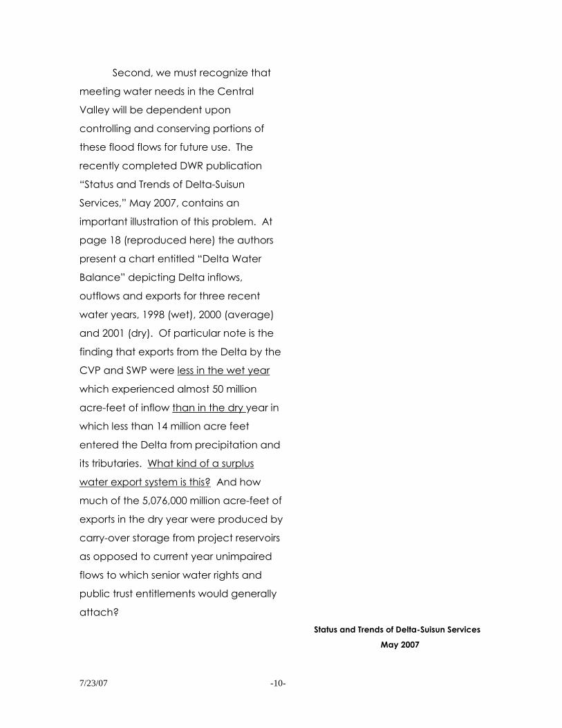
Second, we must recognize that
meeting water needs in the Central
Valley will be dependent upon
controlling and conserving portions of
these flood flows for future use. The
recently completed DWR publication
“Status and Trends of Delta-Suisun
Services,” May 2007, contains an
important illustration of this problem. At
page 18 (reproduced here) the authors
present a chart entitled “Delta Water
Balance” depicting Delta inflows,
outflows and exports for three recent
water years, 1998 (wet), 2000 (average)
and 2001 (dry). Of particular note is the
finding that exports from the Delta by the
CVP and SWP were less in the wet year
which experienced almost 50 million
acre-feet of inflow than in the dry year in
which less than 14 million acre feet
entered the Delta from precipitation and
its tributaries. What kind of a surplus
water export system is this? And how
much of the 5,076,000 million acre-feet of
exports in the dry year were produced by
carry-over storage from project reservoirs
as opposed to current year unimpaired
flows to which senior water rights and
public trust entitlements would generally
attach?
Status and Trends of Delta-Suisun Services
May 2007
7/23/07 -11-
HOW TO PREPARE FOR DROUGHT
A simple exercise is illustrative of this point. Average annual exports by the
CVP and SWP from the Delta total about 5 million acre-feet, whereas average
annual inflows are about 30 million acre-feet. Thus if less than 20% of the annual
inflow to the Delta was exported in each year, total exports would increase, while
exports during the driest years would be limited to 1 to 2 million acre-feet in each
such year allowing sufficient Delta outflow to maintain good water quality in the
estuary and support a healthy ecosystem.
It is interesting to note that Dr. Michael Rozengurt, a prominent Russian
hydrologist testified in the SWRCB Bay-Delta Estuary Hearing (on July 14, 1987)
leading up to D-1379 that every estuary in the world which had significantly
reduced its cyclical natural river in-flows has experienced serious ecosystem harm.
There is a growing scientific consensus that greater outflow, especially in the drier
years, will be necessary to support a healthy ecosystem in the estuary, and of the
need to determine what the “safe export yield” of the Delta will be after reserving
sufficient outflow. Recently, the Pelagic Organism Decline recovery team of
scientists has recommended immediate export reductions in the range of
1.5 million acre-feet per year as a measure to avoid elimination of pelagic
species.
Should we not be redesigning our massive export projects (and perhaps
some others) to increase exports during wetter years while decreasing exports in
drier years, all in line with such “safe yield“ limits?
The Southern California SWP contractors have already taken steps to
accommodate themselves to such an approach with off stream storage and
ground water recharge capabilities, as well as with demand management
initiatives. But the Central Valley customers have done little. Neither Friant Dam
(Millerton Reservoir) nor the Federal share of the San Luis facilities provide much
carry-over storage relative to the annual demands of the CVP contractors. Both
are largely operated on an annual fill and empty strategy. More wet year storage
is needed, but where is it to be found?
Some of it might be provided by new or expanded reservoirs in the
mountains, but this is unlikely given the current economics (especially without

7/23/07 -12-
urban subsidies of agricultural supplies), environmental problems, and the impacts
of global warming on yield of traditional storage reservoirs.
More than likely it would best be provided by flood plain management on
the valley floor, more like it was 150 years ago.
It should be noted that quite a bit of this is already happening. Flood
management for the Sacramento Valley is largely provided not by foothill
reservoirs, but by a system of bypasses and floodways on the valley floor.
Although not much emphasis is placed on flood flow retention and ground water
recharge in these by-passes and floodways today, it could be in the future.
The Tulare Lake Basin presents a model for the areas south of the Delta.
Much of the larger flows of the Kings River are planned to flow into the basin
where they are confined to leveed areas and used for carried-over irrigation
supplies. These operations could be expanded to include flood waters that are
now pushed to the San Joaquin River.
Similarly, the Kern County Water Bank is operated to store excess waters in
wet years in a previously over-drafted ground water basin for subsequent use.
Investigation will reveal many other opportunities to retain storm waters on
the valley floor in historical flood plains for carry-over use and ground water
recharge. Some of these may utilize temporary retention in the by-passes and
basins of the Sacramento Valley for subsequent transfer to storage and recharge
on the floor of the San Joaquin Valley and Tulare Lake, finally utilizing wetter year
export capacity of the CVP and SWP when fewer environmental consequences
can be anticipated. Other opportunities will be found around Los Banos in the
depleted basins under the San Joaquin River accessed from areas like Madera
Ranch, the San Luis Refuge, the Grasslands and from the restoration of flows in the
San Joaquin River itself. An intriguing opportunity will be presented as the
Department of the Interior pays to retire vast acreages (200,000 or more) of the
Westlands Irrigation District impaired by perched ground water without drainage
but overlying an over-drafted ground water basin beneath the Corcoran Clay.
Reoperation of existing reservoirs will be more feasible with operable flood
control basins.
Other opportunities will be presented by the need to create a system of

7/23/07 -13-
weirs and gates to supply flood by-passes and retention basins as the weather
changes south of the Delta from snow to rain. These may extend all the way into
the Delta, with flood easements acquired on currently farmed acreages for
temporary flooding or wetlands creation on lands that don‟t include critical
infrastructure, i.e., controlled flooding and timely pump-out to avoid levee failure
and impacts to adjacent lands, to provide better flood protection to urban areas
and critical infrastructure.
Easement programs should be developed, perhaps through the creation of
a Conservancy, to target critical habitat areas, both aquatic and terrestrial, not
already in public ownership, and to help compensate for loss of farming and
development opportunities.
It is important to point out that the additional dry-year water that can be
supplied by this type of redesign of the CVP and SWP does not need to be
exported from the Delta in dry years since it is already at or near the sites where it
is needed, recharging depleted ground water basins, recreating historical
wetlands and providing carry-over water supplies.
Another important feature is that those projects are primarily designed for
flood control, traditionally a non-reimbursable feature of water project
development. The resulting water supply may therefore be one that agricultural
users could actually afford.
WHAT NEEDS TO BE DONE IN THE DELTA ITSELF?
The Delta is much more than a cross-roads for water development or a vast
and fertile farming area. Probably because its land is relatively flat, relatively
unpopulated and relatively inexpensive, much important infrastructure has been
sited in and across the Delta, all of which is vulnerable to catastrophic levee
failures. Increasingly urban development is encroaching into the Delta as well. It
is also home to one of the great and most varied ecosystems in the world, both
aquatic and terrestrial, as well as a multi-faceted recreational paradise easily
accessible to a large and growing population. All of these assets -- farming,
infrastructure, urban areas, environment, recreation -- are as vulnerable to
catastrophic levee failure as are the water export facilities, although the exports
facilities draw the most political attention.

7/23/07 -14-
In simple terms, agriculture built and maintains the levees, now with modest
support from the State through the Levees Subvention Program. The levees
protect the homes, highways, aqueducts, pipelines, gas fields, deep water
channels, recreation facilities and ecosystem found in the Delta. Water
development squeezes as much water as it can out of the Delta during the drier
years putting enormous and destructive pressure on the ecosystem and the local
uses. In the wetter years, upstream development dumps as much flood water as it
can into the tributaries putting enormous pressure on the Delta levees. Is it any
wonder that commentators now consider the Delta, if current trends continue
(“business as usual”), to be “unsustainable” in the face of future changes?
The “drivers of future change” identified in the Delta Risk Management
Study are:
Subsidence
Global climate change - sea level rise
Regional climate change - more winter floods
Seismic activity
Introduced species
Population growth and urbanization
How do we deal with these “drivers”?
SUBSIDENCE
Subsidence has occurred both with levees and the lands protected by the
levees. As river flood stages have increased due to upstream activities causing
constrictions on the flood plain and due to global warming, levees have been
increased in width and height. Where constructed on compressible soil
foundations (peats and clays), the additional weight has compressed these
foundations, causing settlement and necessitating further construction, more
weight, and more settlement. Each time new levee height or width is required,
the process repeats itself until the foundation soils are fully compressed and
stabilized. Stabilization has largely occurred in many parts of the Delta, especially
7/23/07 -15-
toward the edges.
The second form of subsidence has occurred mainly through oxidation of
organic soils which were dried out (and sometimes burnt for weed control)for
farming, and to some degree, by compression of the dewatered soils from the
weight of farm equipment, not unlike the first form of subsidence discussed above
for the levees. This form of subsidence slows down, and eventually stops, as the
organic soils are depleted which has also occurred in most of the Delta. It is
estimated by local interests well familiar with current soil conditions, that less than
100,000 of the 600,000 acres in the Delta still contain enough organic material to
further subside. Most of these conditions existing in the west-central portions of the
Delta, and these soils usually occupy just portions of islands, not the entire island.
Subsidence of the farmed lands has no impact upon levee stability per se.
The levee structures support themselves and the “design levee” is only dependent
upon a swath of land 200-400 feet wide, which is the foundation upon which the
levee is built.
Although farmed land subsidence can increase the volume of water which
the leveed island will contain if flooded, it doesn‟t contribute significantly to the
stability of the levee itself.
Generally speaking, normal levee maintenance has kept up with the
problems created by subsidence. The bigger challenges are presented by the
next subjects.
GLOBAL CLIMATE CHANGE - SEA LEVEL RISE
Modest sea level rise has been documented at the Golden Gate since the
original reclamation of the Delta, about 6 inches since reliable measurements
began. Most observers feel this phenomenon is increasing and will produce
further rises in a broad range of one to eight feet over the next 50-200 years. At
the upper end of this range the world will be dealing with more difficult issues than
the Delta, and many coastal areas and bays don‟t currently have levee
protection.
Because the Delta is already protected by levees (which have few
encroachments), it is possible to build higher, wider, stronger levees. It also
becomes more expensive as levee building material gets scarcer and more

7/23/07 -16-
remote. It is critical to protect and expand local sources of scarce material, such
as dredged materials from deep water channel maintenance activities and the
rock revetment material from nearby quarried deposits, which are under constant
regulatory pressure.
At some point “Dutch” solutions should be considered, especially if the rate
of sea level rise trends toward the higher estimates. Such solutions include joining
groups of islands together behind common levees (“polders”) to reduce the miles
of levees which need major improvement. In many cases locks would be
appropriate to retain waterway access for recreational and commercial uses.
Consideration should likewise be given to the possibility of constructing
closable surge barriers west of the Delta if it looks like sea level rise will trend
toward the highest estimates, mimicking the Rotterdam Storm Surge barrier types
which Dutch engineers are now studying for the Lower and Upper Mississippi River.
It would be helpful to have the assistance of the Dutch engineers to help plan an
effective future flood control plan.
REGIONAL CLIMATE CHANGE - MORE WINTER FLOODS
Our responses to this “driver of future change” have been described earlier.
Suffice it to repeat here that we need a Central Valley Flood Management Plan
that will identify opportunities to attenuate flood peaks and incorporate
methodologies for future use of the attenuated flows through flood plain retention
and ground water recharge.
SEISMIC ACTIVITY
This is the real “wild card” of the drivers of future change. Although the
Delta has never experienced levee failure from an earthquake, it could tomorrow.
Hence, we should be preparing today.
The seismic vulnerability of the Delta is focused overwhelmingly in the
westernmost Delta because of closest proximity to known active faults, poorest
levee foundations vulnerable to seismic events, and exposure of the CVP, SWP,
and CCWD to potential sea water intrusion at their intake facilities induced by a

7/23/07 -17-
western Delta island failure. As much as 60-70% of the risk of seismic failure is
concentrated on Sherman Island alone, according to the risk studies, and much of
the remaining risk is to Jersey, Twitchell and Bradford Islands.
In spite of the fact that most of the lands on these westernmost Delta
Islands are already in public ownership, little is being done to reduce seismic
vulnerability beyond “hand-wringing.” Subsidence is presumably continuing
under the farming practices of the tenant farmers and major seismic
reinforcement of the most vulnerable portions of the levees is not being
accomplished. We believe the public ownership needs to react quickly to the
perceived seismic threat. Since these westernmost islands are also the closest and
most accessible to the Bay Area population, there is a significant opportunity to
meet recreational and educational needs if portions of these lands need to be
converted from agriculture to attain seismic protection.
Our engineers tell us that a good defense against seismic failure is to widen
the levee so that slumping caused by foundation liquefaction does not take the
whole levee section resulting in a breach. In the process, a lot of material has
been “stockpiled” at the site which can be used to respond to slumping damage
as it occurs.
It should be noted that as you move eastward into the Delta, the seismic
risk decreases, as does the risk of induced salinity intrusion which affects intake
facilities of the in-Delta diversions. If the westernmost islands don‟t fail, the
exposure of the export facilities is greatly reduced. By way of example, the recent
June failure of the Jones Tracts‟ levees did not significantly impact export water
quality. In the Eastern Delta, storm flood is a more significant risk, although as
protection for urbanized areas is designed, seismic protection should be
incorporated at appropriate levels.
INTRODUCED SPECIES
Introduced species have been identified as a big concern only in the last
twenty-five years or so. In fact, some of the species we are now concerned about

7/23/07 -18-
saving (Striped Bass, Threadfin Shad) are themselves introduced.
The Asian-variety clams and crabs that have become problems weren‟t
“invented” in the last 25 years, and ocean-going commerce (and bilge water
dumping) has existed since at least the 1930‟s. Why are they pervasive now,
competing for food with the “desired” organisms?
The answer most likely lies in the changes to the aquatic environment
which have taken place as a result of upstream diversion and Delta exports of
fresh water which would otherwise run through the Delta to Suisun, San Pablo and
San Francisco Bays.
The effect has been dampening of seasonal flow and quality fluctuation
and, contrary to the mistaken assertions upon which the PPIC Report authors
based their conclusions, a saltier Suisun Bay and Delta. The “null” or “mixing” zone
where the forces of the Delta fresh water outflows and the ocean tides achieve
balance in the spring and summer used to be found in Suisun Bay, which is very
wide, typically shallow, and (before the construction of the Montezuma Slough
gate), used to have many dendridic excursions into sloughs extending into the
Suisun Marsh. Because the null zone is the most nutritionally productive area of the
estuary, the combination of primary food production and channel configuration
provided a productive nursery area for the aquatic creatures of the system.
Now the mixing zone has been relocated by reduction of Delta outflow an
average of seven miles further upstream into the deep, dark, steeply banked
channels of the western Delta, conditions in which the “preferred” species do not
thrive. The more salt-loving Asiatic clams have taken hold in Suisun Bay and “filter”
the zooplankton and other primary food supplies out of the system.
The best, and perhaps only, solution to this problem is to return the null or
mixing zone to Suisun Bay by reducing exports from the system during the drier
years, which is proposed earlier in this paper. If the water supply offshore from
Suisun Marsh was re-established at quality necessary to grow preferred plants in
the Marsh, the dendric sloughs could be re-opened into the Suisun Bay which
would undoubtedly help support the “nursery function” of Suisun Bay.
POPULATION GROWTH AND URBANIZATION

7/23/07 -19-
The population is probably going to continue to grow and that may not be
avoidable, or necessarily bad. The key is to keep it from growing into flood-
threatened areas.
We have a big problem. Locally governed land use authority allows urban
development to occur in areas that turn out to lack adequate flood protection for
existing or newly urbanized areas. The federal government doesn‟t adequately
respond to flood threats, and to floods. As a group, the local, state and federal
authorities don‟t have a flood management plan.
This problem transcends the entire Central Valley, although it is most
evident in the Delta. We need to develop a plan whereby we have a common
flood management plan that the local, state and federal authorities can work
together to implement and stop pushing the blame (and liability) back and forth
amongst each other.
Earlier in this paper we called for the development of a Flood
Management Plan for the Central Valley which will assess current and future
conditions. With such a plan we can determine how to operate flood control
features of water storage projects, where to build our levees, and which portions
of the historical flood plain we need to reactivate or recreate “to provide room for
the rivers.” Then we will know where, and where not, to build our cities. And there
will be a sound basis for dividing governance responsibility between local,
regional and state agencies on the basis of designated uses.
CONVEYANCE
Once all these “drivers” have been addressed as discussed above, we can
“tinker” with Delta conveyance strategies to optimize the system without mere
reallocation of shortage.
From a Delta perspective, we are fearful that mechanisms that make it
possible to short the Delta of its water supply will be used, ultimately, to short the
Delta of its water supply. We also believe that little has been done to consider the
implications of isolated transfer since the 1982 Referendum and dispute the recent
statement attributed to the Governor that isolated Delta conveyance “has been
studied to death.” We have the following concerns about isolated transfer

7/23/07 -20-
facilities:
The fresh water inflow to the Delta has already been greatly reduced by
bypassing the Delta exports south from Friant, west from the Tuolumne, and west
from the Mokelumne. The inflow is also reduced by the consumptive use of
upstream water to grow food and support urban growth. If a Peripheral Canal
were used to also keep Sacramento water out of the Delta, there would inevitably
be further substantial increase in the salinity of water in Delta channels. Exports
from Delta channels would then be deemed too salty. The canal would,
therefore, have to convey all the water that is now exported south and west from
Delta channels.
The Peripheral Canal would be a barrier to flood waters from south and
east of the Peripheral Canal alignment. During major floods that exceed the
capacity of the San Joaquin and Mokelumne channels, the flood stage would
increase against levees that protect tens of thousands of homes. The canal itself
becomes a potential threat to flood adjacent areas if it breaches (and we are
advised that current design and cost estimates do not include seismic protection).
The Peripheral Canal would require vast expenditures to construct
massive new levees on both sides of a 42 mile alignment through the very areas
where we now have problems maintaining levees.
If billions of dollars are spent on a Peripheral Canal, those funds won‟t be
available to improve existing Delta levees, and to implement measures that could
impede the flow of Bay water into the Delta in the event of multiple levee break if
it occurs at a time when outflow to the Bay is not maintained by flood flows.
If the basic configuration of Delta channels and land uses is not
maintained, there will be an increase in the tidal actions which brings Bay water
into the Delta exacerbating water surface elevation during flood flows and loss of
water to meet net Delta outflow requirements. Numerous Peripheral Canal
proponents propose that levees be breached and/or allowed to fail for lack of
maintenance or repair. As each island flooded it would increase Bay water
encroachment. “Water use” by evaporation from the surface of flooded lands
exceeds agricultural use of water from farmed lands by about two acre-feet per
acre. It would also increase wave erosion on other levees. If the basic

7/23/07 -21-
configuration is not maintained, the Delta will become a salty inland bay.
As the Delta became an inland bay, the levees that protect roads,
housing, utilities, railroads, recreation facilities, etc., would experience substantial
wave and seepage problems. Their ability to protect the public‟s interests would
be seriously diminished. It may be far cheaper to fortify the existing levees that
protect the infrastructure than to relocate or fortify the infrastructure itself.
Delta agriculture now produces food on about half a million acres of
Delta lands. The production would be largely destroyed by increased salinity and
by the uncertainty of levee protection caused by a Peripheral Canal. Agricultural
Code 411 states that California must not become dependent on a net import of
food due to failure to provide an adequate agricultural water supply. Using a
Peripheral Canal to increase salinity and destroy half a million acres of food
production in the Delta is incompatible with that mandate.
The salinity increase caused by a Peripheral Canal would cause a
violation of most, if not all, of the SWRCB‟s salinity standards and contracts with
Delta water agencies.
The reallocation of an inadequate water supply and other
consequences of a Peripheral Canal would violate the Delta Protection Statutes,
water rights law, and the Environmental Protection Act.
The initial effect of the Peripheral Canal on Delta fishery is controversial.
The entire Sacramento River anadromous fishery (Salmon, Steelhead, Shad,
Sturgeon, Striped Bass, etc.) would need to pass by its intake and no fish screen of
this magnitude has ever been proven effective. Delta Smelt will follow the fresh
water in the Delta to the pump intakes (whether they are at Tracy or Hood) when
water quality deteriorates below the point of export.
It is not clear that there is a routing available for a Peripheral Canal with
all of the urbanization that has occurred since 1982, without relocating it westward
into the very areas that are thought to be vulnerable to flooding because of
subsidence, poor foundation material and seepage problems.
Who would be willing to pay for it? The 1982 Referendum illustrated the
reluctance of the voters and a recent court decision reconfirms the obligation of
the State to submit bond proposals to the voters.

7/23/07 -22-
The proposals to improve the efficiency of passage of water through the
interior of the Delta bear more promise from both a political perspective and a
“reversibility” perspective, including the recent suggestions of ways to separate
the streams carrying fish from the flows being exported in the South Delta while still
maintaining sufficient flow through the Delta to maintain a common pool of fresh
water for use within and without the Delta.
Recent proposals incorporating such separations include “Straw Proposal
2” the so-called “Eco-Crescent” presented to the Delta Vision Stakeholder
Coordination Group at its recent workshop in Courtland on June 13 and 14, and
Dr. Russ T. Brown‟s “Proposal to Reconnect the San Joaquin River to the Estuary”
dated March 23, 2007. Many features of these concepts included within the
“Flexible Delta” Scenario being developed by the Delta Visions Stakeholder
Coordination Group may fit within this concept, although others would not. In
fact, a group composed of representatives of the North, Central and South Delta
Water Agencies and some environmental groups submitted a tributary corridors
concept to CALFED several years ago which included a physical barrier to
separate San Joaquin River Salmon at the head of Old River to keep the fish in the
main stem of the San Joaquin River away from the influence of the export
pumping from Old River while enhancing other environmental features of Old and
Middle Rivers.
All of these proposals appear to provide protection to important Delta
fisheries without negatively impacting Delta water quality, such as is the case with
isolated (peripheral) transfer facilities, and are worthy of study and consideration
in conjunction with the other suggestions made here.
BLUE RIBBON TASK FORCE ISSUE ASSESSMENT
Before concluding, we wish to point out how the approach recommended
in this paper responds directly or by implication to the issues which the Governor
has addressed to the Blue Ribbon Task Force in his Executive Order 5-17-06
initiating the Delta Vision Process:
The environment, including aquatic and terrestrial functions and
7/23/07 -23-
biodiversity.
Our approach is to restore enough of the historical Delta outflow pattern
necessary to return the mixing zone to the Suisun Bay to reclaim the ecological
vitality of the Bay-Delta Ecosystem, while replacing displaced exports with flood
plain recapture, ground water replenishment, and demand management
initiatives. This approach will benefit aquatic and terrestrial populations in the
entire Central Valley through enhanced drier year stream flow, water quality and
wetland restoration, while providing protection to the largest fresh water estuary in
the Americas and the 700+ native species of fish, animals and plants that depend
upon it.
Land use and land use patterns, including agriculture, urbanization, and
housing.
Developing and implementing a Flood Management Plan for the Central
Valley will help resolve existing governance problems by designating, from a
regional perspective, where urbanization can safely occur and where agriculture
and other open-space uses must remain, and by providing financing to
implement the plan. Such a Flood Management Plan would also help determine
whether it is more cost effective to protect legacy communities, roads, and other
Delta infrastructure by strengthening existing levees or by constructing ring levees
or consolidating and armoring utility corridors.
Transportation, including streets, roads, highways, waterways, and ship
channels.
This paper favors maintaining the existing land patterns in the Delta to
appropriate risk levels given the protected use. Seismic concerns would be
stressed in the westernmost Delta and for levees that protect urban areas. Flood
risks would be addressed through a combination of flood attenuation in upstream
flood plains and rehabilitation and maintenance of Delta levees, in accordance
with sound engineering practices. Greater risk would be assigned to levees which
don‟t protect important infrastructure, recognizing the need for both a flood
easement program and robust emergency response.
Delta Engineers assure us that there are techniques to protect Delta levees
to address seismic risk and future conditions relating to global warming. If global

7/23/07 -24-
warming begins to reflect higher estimates, “Dutch solutions,” such as polders and
tidal surge barriers, should be considered for timely implementation.
Utilities, including aqueducts, pipelines and gas/electric transmission
corridors.
As noted above, levee systems that protect at-risk infrastructures should be
maintained to less at-risk standards. The utilities themselves are currently involved
in this type of planning and construction, including multiple routing and
consolidation.
Water supply and quality, municipal/industrial discharges and urban and
agricultural runoff.
The current system of regulation is adequate to meet existing and
emerging public health and safety objectives, and to incorporate new
technologies as they appear. Public funding needs to be available to address
unusual issues, emergencies and environmental justice concerns.
Recreation and tourism, including boating, fishing and hunting.
This paper‟s approach would enhance aquatic and terrestrial resources
throughout the Central Valley and specifically preserve and support recreation
and tourism through appropriate land-use designations established by a Central
Valley Flood Management Plan, and by the restoration of a robust fresh water
environment in the Delta consistent with its history.
Flood risk management, including levee maintenance.
This paper calls for establishment and maintenance of levees throughout
the Delta appropriate for the protection of the assets they protect and the
stresses they will face, and a robust Emergency Response Plan for when, and if,
they fail. Ultimately, it is either extremely expensive or impossible, to only protect
some of the levees in the Delta.
Emergency response.
No mater how well designed and constructed, any levee can fail, if not
from earthquake, floods or beavers, then maybe from acts of terrorism. We must
have a robust Emergency Response Plan, including quick financial response
capability. Delta interests have promoted and participated in emergency
response planning, including a set-aside of Propositions I-E and P4 funding to jump

7/23/07 -25-
start emergency response.
Local and state economies.
Too often discussion about Delta Vision focuses on water export interruption
and ignores the devastating impact a major flooding in the Delta would have on
the ecosystem, transportation, utilities and urbanized populations. Any viable
Delta Vision cannot envision long-term loss of any significant portion of the Delta
land mass or the levees that provide its protection. This paper also describes a
methodology for providing the water supply to the Delta exporters which they
were supposed to get from the expansion of the water project in a way that
addresses flood issues meaningfully with the prospect of global warming and is
sensitive to environmental issues.
CONCLUSION
We have become dependent, perhaps unwittingly, upon the Delta to
support a wide variety of functions, from ecosystem, to agriculture, to
transportation of people, water, energy, and commodities, to urban communities
and their recreation needs. We need to develop a plan that deals with all of
these functions, not just inter-regional water transfer. We need to look beyond
the Delta for solutions.
This plan needs to look forward and anticipate changes that appear
certain to occur in the twenty-first century and beyond, and not be tied to
concepts developed to deal with the past.
We hope that you have found this paper to be useful in that regard.