Embed Size (px)
Citation preview
A Survey of Historic Architecture in Grayson County, Virginia
including the towns of Independence and Fries
Conducted for Virginia Department of Historic Resources
Richmond, Virginia
Conducted by Gibson Worsham, Architect
Winter 2001 – Spring 2002
2
2
TABLE OF CONTENTS Abstract 3 Acknowledgments 3 List of Figures 4 List of Plates 5 Introduction/Description of the Project Introduction 6 Description of Survey Area 7 Historic Context Introduction 9 Previously Identified Historic Resources 9 Historic Overview of the Survey Area 13 European Settlement to Society (1607-1752) 13 Colony to Early National Period (1753-1830) 14 Antebellum Period (1831-1860) 26 Civil War (1861-1865) 36 Reconstruction and Growth (1866-1916) 36 World War I to World War II (1917-1945) 53 The New Dominion (1946-Present) 60 Survey Results by Theme and Period 63 Research Design Introduction 72 Methodology 72 Expected Results 72 Survey Findings 73 Evaluation Potential Historic Designations and Boundaries 73
Eligibility Standards 74 Properties Eligible for Listing 77 Preservation Recommendations 79 Glossary 81 Bibliography 86 Appendices 88 Numerical Inventory of Surveyed Properties Alphabetical Inventory of Surveyed Properties
3
3
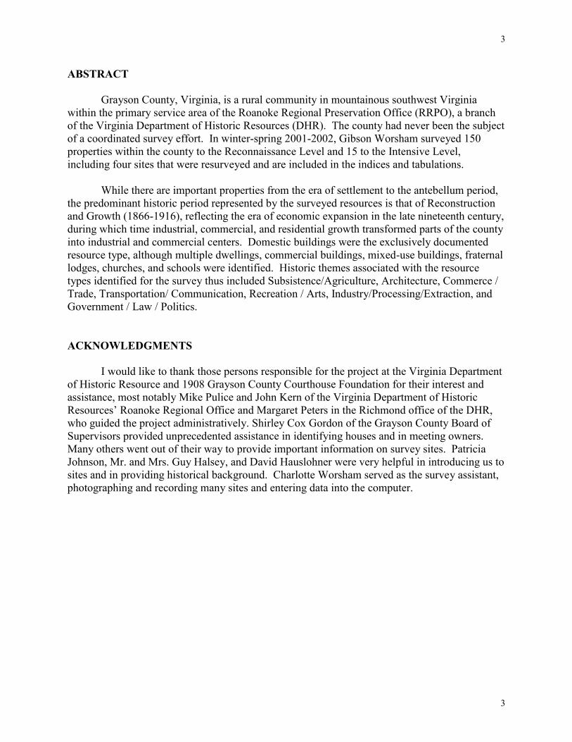
ABSTRACT Grayson County, Virginia, is a rural community in mountainous southwest Virginia within the primary service area of the Roanoke Regional Preservation Office (RRPO), a branch of the Virginia Department of Historic Resources (DHR). The county had never been the subject of a coordinated survey effort. In winter-spring 2001-2002, Gibson Worsham surveyed 150 properties within the county to the Reconnaissance Level and 15 to the Intensive Level, including four sites that were resurveyed and are included in the indices and tabulations. While there are important properties from the era of settlement to the antebellum period, the predominant historic period represented by the surveyed resources is that of Reconstruction and Growth (1866-1916), reflecting the era of economic expansion in the late nineteenth century, during which time industrial, commercial, and residential growth transformed parts of the county into industrial and commercial centers. Domestic buildings were the exclusively documented resource type, although multiple dwellings, commercial buildings, mixed-use buildings, fraternal lodges, churches, and schools were identified. Historic themes associated with the resource types identified for the survey thus included Subsistence/Agriculture, Architecture, Commerce / Trade, Transportation/ Communication, Recreation / Arts, Industry/Processing/Extraction, and Government / Law / Politics. ACKNOWLEDGMENTS I would like to thank those persons responsible for the project at the Virginia Department of Historic Resource and 1908 Grayson County Courthouse Foundation for their interest and assistance, most notably Mike Pulice and John Kern of the Virginia Department of Historic Resources’ Roanoke Regional Office and Margaret Peters in the Richmond office of the DHR, who guided the project administratively. Shirley Cox Gordon of the Grayson County Board of Supervisors provided unprecedented assistance in identifying houses and in meeting owners. Many others went out of their way to provide important information on survey sites. Patricia Johnson, Mr. and Mrs. Guy Halsey, and David Hauslohner were very helpful in introducing us to sites and in providing historical background. Charlotte Worsham served as the survey assistant, photographing and recording many sites and entering data into the computer.
4
4
LIST OF FIGURES 1. Project Location. 8 2. Detail of C. R. Boyd Map of Grayson County, Virginia, 1897. 12 3. Floor plan of William Bourne House. 26 4. Floor plan of Stephen G. Bourne House. 27
5
5
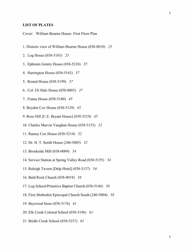
LIST OF PLATES Cover: William Bourne House- First Floor Plan 1. Historic view of William Bourne House (038-0010) 25 2. Log House (038-5183) 25 3. Ephraim Gentry House (038-5210) 25 4. Harrington House (038-5163) 37 5. Round House (038-5199) 37 6. Col. Eli Hale House (038-0003) 37 7. Frame House (038-5180) 45 8. Boyden Cox House (038-5129) 45 9. Rose Hill [C.E. Bryant House] (038-5219) 45 10. Charles Marvin Vaughan House (038-5153) 52 11. Ramey Cox House (038-5214) 52 12. Dr. H. T. Smith House (240-5005) 52 13. Brookside Mill (038-0009) 54 14. Service Station at Spring Valley Road (038-5155) 54 15. Raleigh Tavern [Delp Hotel] (038-5137) 54 16. Bald Rock Church (038-0019) 58 17. Log School/Primitive Baptist Church (038-5146) 58 18. First Methodist Episcopal Church South (240-5004) 58 19. Baywood Store (038-5176) 61 20. Elk Creek Colored School (038-5196) 61 21. Bridle Creek School (038-5237) 61
6
6
INTRODUCTION/DESCRIPTION OF THE PROJECT Introduction This survey was conducted in cooperation with the Grayson County Board of Supervisors and the 1908 Courthouse Foundation. Additional assistance came from Grayson County Historical Society, the Wythe-Grayson Regional Library, and other organizations and individuals. The project was funded by State Survey and Planning Funds administered by the Virginia Department of Historic Resources and its Roanoke Regional Preservation Office. The survey was initiated with several objectives: 1) to extend the survey of historic resources across the county. 2) to provide local government and other planning agencies with information about
resources, that may be used in preparation of a preservation plan for the county. 3) to evaluate the eligibility of the survey area for listing in the Virginia Landmarks Register and the National Register of Historic Places. The survey project was carried out by Gibson Worsham, who organized and undertook the fieldwork and prepared the final report. Charlotte Worsham assisted Worsham with fieldwork, data entry of survey information into the DSS system, and in organizing materials. Reconnaissance level surveys provide the following basic information about an historic resource:
1 Form 2 Date 3 Address/location 4 Physical condition 5 Threats, if any 6 Historic context 7 Exterior architectural features (type/form, material, treatment) 8 Architectural description 9 Statement of architectural and historic significance 10 Brief description of secondary resources 11 Site plan 12 Photographs documenting each resource, contributing and non-contributing.
Intensive level surveys provide a more detailed documentation of an historic resource,
including a description of the interior features of the resource. In addition to the information listed above, the following information is included in an intensive level survey:
1 Function(s) of property 2 Period context 3 Interior description 4 Historical events
The final survey products also include a survey report that discusses the historic context
7
7
of the survey area based on appropriate themes recognized by DHR, evaluates the significance of the resources, and provides recommendations for further study, preservation planning, and educational projects. Also included are a set of USGS topographic maps indicating the location of all surveyed properties and a scripted slide show. The survey report will serve as a resource for making land-use decisions and planning for future survey, evaluation, and treatment of architectural resources within the study area. The Study Area
Grayson County is located on the Virginia/North Carolina border in the Southwest region of Virginia. It is bordered by Carroll County on the east; Wythe, Smyth, and Washington counties on the northwest; and Ashe and Alleghany counties in North Carolina on the south. Grayson is roughly divided into a number of rural communities. These were used along with the USGS Quad map boundaries for mapping historic sites in the county.

8
8
Figure 1: Project Location
9
9
HISTORIC CONTEXT Introduction Historical information for this survey project was gleaned from various local, regional, and state archives, including the offices of the clerk of the circuit court of Grayson County, the Wythe-Grayson Regional Library, Independence, Virginia; Newman Library of Virginia Polytechnic Institute & State University (VPI&SU), Blacksburg, Virginia; the RRPO, Roanoke, Virginia; the DHR Archives, and the Library of Virginia, Richmond, Virginia.
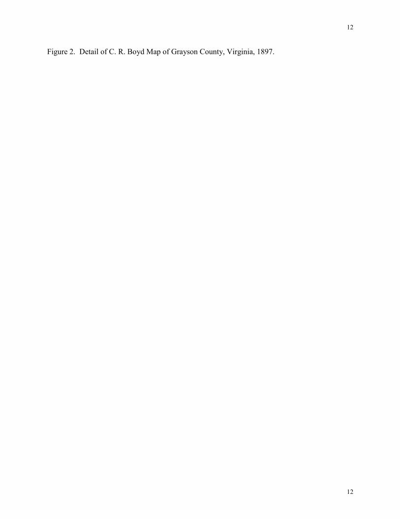
The history of Grayson County has been well presented in publication of several historical overviews in recent years. Basic general works that include considerable material on individual buildings are Grayson County: A History in Words and Pictures (Independence, Virginia: Grayson County Historical Society, 1976); Grayson Memories, vol. 1 (Independence, Virginia: Grayson Historical Society, 1992); Grayson Memories, vol. 2 (Independence, Virginia: Grayson Historical Society, 1999); and Bicentennial Heritage, Grayson County, Virginia,,1793 (Independence, Virginia: 1908 Courthouse Foundation, 1995). A series of calendars issued by the Grayson County Historic Society include dozens of historic building sketches with useful written captions. Town and community histories include Spring Valley: Yesterday-Today (Wytheville, Virginia: Wythe House Press, 1994), A History of the Town of Fries, Virginia (Collinsville, Virginia: Collinsville Printing Co., n. d.), and several others. Primary sources were reviewed for official and indirect information on properties in Grayson County. Deed, tax, and will books in the local jurisdiction were consulted for supplementary information. Historic maps of the area, in particular the 1897 Boyd Map of Grayson County, were essential to understanding the resources. The photograph collections at the Wythe-Grayson Regional Library and the 1908 Courthouse aided in understanding the county’s background. Oral history interviews with many house owners and residents, added greatly to understanding of the area's change through time. Previously Identified Historic Resources Prior to beginning fieldwork, previous information in the DHR Archives on architectural sites in the survey area was reviewed. Although there were 273 properties listed, Grayson County was not well represented in the Virginia Department of Historic Resources survey files. The towns of Fries, Independence, and Troutdale had received limited attention, with two sites in Fries, the Washington Mill (038-0012) and the Fries Recreation Center (220-5001), and three in Independence, including the 1908 Courthouse (240-5001) and the Bourne-Davis House (240-5004). A further twenty-three properties in Independence and forty-three structures in Troutdale were identified as part of Section 106 review associated with highway construction. While those in Independence generally did not meet standards for inclusion in this project, many of those in Troutdale did. Several major sites outside the towns, such as the Old Grayson County Courthouse (038-0004) and Clerk’s Office (038-0005), the William Bourne House (Walnut Hill, 038-0010), and Ripshin Farm, the Sherwood Anderson House (038-0008), had received
10
10
attention, some as early as the 1950s as part of a Historic American Building Survey project. These, together with several other sites inventoried in the 1950s and later, comprised about twenty-four properties. Some of these, including the Parsons House (038-0006) and the Cox House (038-0001) were originally noted in the 1950s because they appeared to be unusual in form or early in date, while the Eli Hale House (038-0003) and the Brookside Farm and Mill (038-0009) were identified at the same time because of their substantial form and important historic associations. Few of these forms were complete or comprehensive in scope. An additional 176 rural county survey forms represented state-sponsored bridge surveys and Section 106 review for highway projects, mostly buildings that do not meet the standards for a limited reconnaissance survey such as this project.
Three properties were listed in the National Register of Historic Places and the Virginia Landmarks Register: the Old Grayson County Courthouse (038-0004), the Old Grayson County Clerks Office (038-0005), Ripshin Farm, the Sherwood Anderson House (038-0008, a National Historic Landmark), and the 1908 Grayson County Courthouse (240-0001). The survey numbering system for the county consists of the prefix 038 for rural sites. The sites were numbered starting with 038-0001 through 038-0089. Thereafter, all sites were given 5000 suffixes, in order to clean up the survey numbering system across the entire state file structure, beginning with 038-5001. Similarly, the towns of Fries, Independence, and Troutdale, which have different prefixes (220, 240, and 314), received new 5000-root suffixes, as in 220-5001.
11
11
Expected Results
Since Grayson County served primarily as a home to small mixed farms and low- capital industry, the majority of properties surveyed were expected to be plain and modest in scale, while the unusually rich bottomlands and valleys indicated that a few substantial antebellum and significant early-nineteenth-century dwellings might be anticipated. Resources associated with this development would include dwellings, farmsteads, and related agricultural outbuildings such as meat houses, barns, granaries, and animal shelters. Government resources would be few, consisting of a courthouse and its subsidiary structures and one or two post offices.
Geography would tend to suggest building locations. Rich valleys would be expected to
develop as seats of prosperous villages with churches, stores, and schools. Population statistics and historic farming trends suggested that few slave-related buildings would be found. It was expected that most of the resources would date from the late nineteenth to the mid-twentieth centuries. It was anticipated that few buildings would fully embody any national design trends or professional designs until well into the twentieth century. Most buildings would participate in the rich vernacular traditions that dominated architectural decision-making in rural Virginia for centuries.
The arrival of the railroad at the turn of the twentieth century promoted growth of several
industrial and transportation-based communities. These were expected to survive in relatively unscathed form to the present day due to the economic slowdown in recent decades.
12
12
Figure 2. Detail of C. R. Boyd Map of Grayson County, Virginia, 1897.
13
13
Historic Overview
Grayson County, rich in resources of timber, minerals, farmland, and water power, was formed in 1792 from a portion of Wythe County. The Southwest Virginia county was named in honor of William Grayson, one of Virginia’s first two senators. Comprised of 441 square miles of rugged mountains and wide river valleys, the county is bounded to the northwest by Washington, Smyth, and Wythe counties, with the line running from White Top Mountain and Mount Rogers, Virginia’s highest peaks, east along the ridges of Iron Mountain, and on the south and east by the hills and bottomlands along the serpentine lines of the New River. In many ways the county is more closely allied with the easily accessed areas across the border in North Carolina.
The county is broken up into several valleys by intermediate mountains, each valley associated with a creek draining into the river. The mountains include, from west to east, Kindricks Knob and Buck, Pine, and Briarpatch mountains. The watercourses that define the geography of the south section of the county include, also from west to east, Horse, Grassy, Wilson, Fox, Bridle, Saddle, Brush and Peachbottom creeks. Elk Creek, flowing east across the top of the county, gives it name to a lush and prosperous valley between Iron and Pine Mountains. Spring Valley, in the northeastern corner of the county, is a similarly prosperous farming section. Many elevated and isolated highland sections encircle the county, including White Top at the west end, and Grant, Flat Ridge, Comers Rock, Robert’s Cove, and settlements on the sides of Pine and Buck mountains. Hilly agricultural regions such as Potato Creek and Peach Bottom were settled along the North Carolina line on the south side of the New River.
Roads crisscross the county from gaps along the north and ferries on the south and east. The original settlements were on roads near prominent New River crossings, including the first courthouse in the home of William Bourne in Spring Valley, and the first permanent courthouses at Old Town. As the county experienced growth in industry and timber harvesting, new communities grew up on all sides, including Fries and Galax on the New River in the county’s eastern edge and Mouth of Wilson, all mill towns of a variety of scales. Independence, a new courthouse town, was laid out nearer the center of the county in 1850. Troutdale and Whitetop City, industrial towns served by newly developed railroads, grew up in the high country at the county’s far western end 1607-1750 European Settlement to Society
There did not appear to be any permanent settlements of Indians in Southwest Virginia by the time of the first accounts of the area in 1671. Dr. Thomas Walker recorded no encounters with natives in 1749. He did notice, however, the presence of formerly burned clearings known as “Indian Old Fields.” The earliest white men who came to the Southwest Virginia were Indian traders and hunters who followed what was an old buffalo trail north of Grayson County (now the route of State Route 11) to trade with the Cherokees south of the region [Hill Studio 1997: 14].
14
14
James Patton led the first surveying expedition into the southwest Virginia region, then part of Augusta County, in 1748. The goal was to locate the 120,000 acres of the best land on the western waters granted to Patton in 1745. After the 1748 expedition, the Loyal Land Company was formed with a grant of 800,000 acres in Southwest Virginia, including present-day Grayson County. Frontiersmen were present in the region, as confirmed by records of their encounters with the early excursions of Patton and Walker. These men, who traded with the Indians, often provided guidance and advice. [Hill Studio 1997: 17]. 1750-1789 Colony to Nation
Some families attempted to settle in area in the early 1750s. In 1752, a treaty with the Iroquois reconfirmed the right of Virginians to settle lands as far as the Ohio River. The hostilities of the French and Indian War, however, interrupted these early efforts at permanent settlement. During the war from 1754-1763, the frontier was the battleground, and many of the early settlers were either killed by Indians or driven from their homes to the safety of the east. Although the treaty ending the war was signed in 1763, it was accompanied by the Proclamation of 1763 in which the English government, unwilling to invest in the settlers’ protection or to further provoke the Indians, forbade the colonists from settling the western frontier. The country was not legally opened for settlement until the Treaty of Fort Stanwix in 1768. Permanent settlement of the region dates to the period following the French and Indian War. Most settlers in the area were driven out by the treat of Indian attack. They took refuge with the Moravians near Salem, North Carolina and did not return until after 1765.
The Indians continued to pose a threat in the area, however. Dunmore’s War from 1773-1775 marked a period of Indian raids throughout the region, including a raid through Rich Valley in September 1774. Several forts were built in the area, including one at Royal Oak. Arthur Campbell was in charge of recruiting men from the area, and in 1774 militia mustered at the Town House. Dunmore was defeated in 1776 at the battle of Gwyn’s Island. In 1776 the Cherokees were defeated in the Battle of Long Island above Kingsport, Tennessee. [Hill Studio 1997: 17]
Some of the best land in Grayson County was surveyed for the Loyal Land Company as part of a large grant in the region intended by the colonial government to enhance and encourage settlement. Land was surveyed at the Peach Bottom Tract for the Loyal Land Company in 1753. John Cox was in the area by the same year, in what was then a remote part of Augusta County. David Cox and Enoch Osbourne were on New River by 1765, soon after the end of the war. Enoch Osbourne and his brothers Solomon, Ephraim, and Jonathan, settled near the mouth of Bridle Creek. George Reeves and John and Samuel Collins had arrived by 1767. Andrew Baker, who had settled at the mouth of the Little River, was driven out by Indian raids [Fields1976: 36].
Early local leaders were military. Companies of militia were apparently established under the command of Captains John Cox and Enoch Osbourne at an early date and these proliferated as the population grew and the companies were divided. In 1774, David Cox was commissioned as a Lieutenant in John Cox’s Company. In 1778-80, Grayson was a hotbed of Tory activity, as residents of the area attempted to raise an insurrection against the authorities
15
15
and made several attempts to destroy the lead mines. Captain John Cox gave information in 1779 about a group of local Tories, who had held, threatened and robbed him. The Tory activity was thwarted [Fields 1976: 35-39]. John Cox’s Company also built a fort at the mouth of Peach Bottom Creek [Fields 1976: 42].
Many of the families that would contribute to the development of Grayson County into
the twentieth century settled in the area during this time. In 1765, William and Rosamond Bourne settled at Knob Fork on New River. Members of the Hale family, including Edward and Lewis Hale, were among other early inhabitants. The former settled at Wolfe Creek in 1776 and the latter on Elk Creek. Lewis Hale is said to have selected the locality over Kentucky after his brother-in-law was killed on the road to the western lands. Rosamond Bourne’s father, Maj. Minitree Jones, settled near an important river crossing as did several other men named Jones [Fields 1976: 20-21].
Other early settlers include John Long, William Long at Long’s Gap, William Henry Boyer and Jacob Boyer, and members of the Cornett and Delp families, as well as James Sage, who received a grant on Elk Creek in 1782. A romantic story has received considerable circulation concerning James Sage’s daughter, Caty, who vanished in 1792. Her brother found a white woman identified as Caty in Kansas many years later who claimed to have been abducted in the east by a white man and turned over to the Cherokees, from whom she had passed to the Creeks and finally the Wyandots [Bland 233 and Fields 1976: 25-27].
The early settlers of the area were of a variety of ethnic and religious backgrounds.
Southwest Virginia was settled by numerous dissenters from the official Church of England, particularly Scotch Irish Presbyterians and persons of German Reformed or Lutheran backgrounds. These early congregations often met in private homes before constructing churches. A church known as Hale’s Meeting House, built in the Elk Creek area by Lewis Hale, is said to have been the earliest church in the county [Fields 1976: 20]. It is mentioned in a 1793 road report. The Methodist movement came to the area in 1788 with biennial visits from Bishop Asbury, father of the Methodist Church in America. The first conference held west of the Allegheny Mountains was held in Washington County in 1788. Asbury came to the Grayson area immediately afterward, taking as his sermon topic the text “How beautiful upon the mountains are the feet” in a service held at a chapel in the Osbourne settlement near New River. He passed through the area two more times over the next few years [Fields 1976: 68-69]. His presence in the county had a profound effect, because a clear majority of the residents of the county have remained Methodists to this day. The number of farms in the area before the Revolution is unknown, but is reasonable to assume that most, if not all of the residents were engaged in some form of agriculture. Most of the early farms were small with only a small portion cleared and fenced for cultivation. Over time, buildings and fences were modified as the prosperity of their owners permitted. Crops were varied and yields were low by later standards. Livestock and their by-products were a crucial element of early Grayson County agriculture. Horses were used primarily for transportation and as draft animals. Maintaining a breeding stallion was a profitable venture engaged in by a few residents and carefully taxed by the state. Cattle were the most numerous farm animal. Herds were driven to distant markets. Cattle were usually not housed in permanent
16
16
buildings.
Education in the period was the responsibility of the family. Wealthy families usually employed tutors. Ministers also taught either in their homes or operated small schools. Subsistence and commercial agriculture was the primary occupation during this period. Industry consisted primarily of the small custom or grist mills needed to convert wheat and grains raised to flour, cornmeal and feed needed by the farmers, their families, and livestock.
1790-1830 Early National Period
Grayson County population grew substantially during the period and with it came limited growth in the institutions of religion and education. The population increase also meant that the county seat at Wytheville was too far and too small, so the citizens of the area petitioned the state to create a new county out of Wythe to be called Grayson. In 1792 the state established the new county. According to tradition, William Bourne ran for election to the state legislature as a advocate for formation of a new county. Although he lost the election, he found success in the new county, partly due to the support of William Grayson, who was one of the state’s first two senators [Fields 1976: 50-51].
The first county court was held in May of 1793 at the home of wealthy landowner
William Bourne. The justices of the court were sworn in as were the sheriff, county clerk, and other officials, including the officers of a county militia. That William Bourne was the county’s most substantial, influential, and perhaps its most educated resident is suggested by the selection of his house as the site of the first court and himself as the county clerk. William Bourne also served as the county’s first delegate to the state legislature [Bicentennial Heritage 154]. Physical evidence suggests that the William Bourne House (038-0010) standing today was probably built by that time. It may have been the best-built structure in the county, able to adequately house the court in session (see below for a description). In July of 1793, William Bourne received a license to keep an ordinary at his house [Grayson County Order Book 1793-1794]. He did not renew after the court moved from his house [Grayson County Personal Property Books].
There is no documentary evidence that the barn at the Bourne property was used as a first
meeting place for the court as tradition avers. In fact, the court records say “the house of William Bourne” [Grayson County Order Book 1793-1794: 1-3]. Large barns were not common anywhere in the region, as agricultural practices required neither cattle nor hay to be housed indoors [see below and Worsham 1988: 34]. It is very possible that the now-demolished Bourne Barn contained an early single-crib barn, but the double-crib, central-aisle barn shown in photographs appears from its form and detail to date from the antebellum era.
In June 1793, the court ordered that the county seat was to be “at the place known as Rose’s Cabbins.” The house it was then meeting in was to be “the place of holding courts until the publick buildings shall be erected” [Grayson County Order Book 1793-1794]. Tradition holds that “Rose’s Cabbins” refers to Rosamond and William Bourne’s settlement. Examination of the records suggests, however, that “Rose’s Cabbins” apparently refers to a settlement on the main road on the east side of the New River on the site of what would become Greenville, the seat of Grayson County. In the late eighteenth century, tracts of land were often developed with
17
17
a series of small, semi-permanent log buildings with crude chimneys and earthen floors known as “cabins [Worsham 1988].” Rose’s Cabbins may have combined a central location with substantial structures capable of housing the justices and other attendees overnight.
The court continued meeting at the William Bourne House until June of the following
year, when it moved to the new courthouse [Grayson County Order Book 1793-1794]. This new courthouse was probably built of logs, as were most late-eighteenth-century courthouses in the region. In 1809, when the log building was probably beginning to seem very inadequate, the court ordered a new brick building, of which no other record remains Fields 1976: 78].
Greenville probably resembled other lesser county seats of the similar date, such as
Tazewell, Marion, and Newbern, in possessing a single central street lined with houses and businesses, including the centrally placed courthouse on one side of the street and a nearby tavern to accommodate the court and its clients during a period of several days each month. The courthouse was supplemented on the lots owned by the county by a small jail and a clerk’s office, where records were kept.
Two principal persons built on their lots in Greenville. Martin Dickenson, county clerk
and hotel-operator, also made his living as a farmer. Dickenson came to the county in 1792 as an employee of the William Bourne, Sr., engaged in transporting “huge boat loads of cast hollow ware” made at the Blair and Dickey Furnace down the Holston River to Alabama and Tennessee. He served also as deputy clerk under William Bourne until he became clerk in the second year of the county’s life, and served until 1834 [Fields 1976: 154]. The improvements on his property in the town of Greenville, estimated at $1,164 and $291, were among the most valuable in the county in 1820 [Grayson County Land Books]. His developments on seventeen lots in the town included a hotel, managed by his wife, Mary, until her death in 1860 [Bicentennial History 1995: 204]. Robert Nuckolls and his sons were the town’s early merchants, eventually with branches at Elk Creek and Bridle Creek [Bicentennial History 1995: 105]. Nuckolls owned 12 lots in Greenville in 1820, with buildings on them worth $200, $100, and $10 [Grayson County.Land Book, 1820].
The new county included the area of Carroll County as well as the current Grayson section, so a central and convenient location for a courthouse was selected near the New River and the main roads. The town of Greenville was laid out on the east bank of the New River. The primitive state of roads in the county was constantly under improvement as the court ordered landowners and the county surveyor to lay out and improve routes crisscrossing the county. A road was laid out from the Blair and Dickey Furnace to run past the new courthouse to an iron forge. This new Furnace Road was a sort of transportation spine for the county, from which many other roads extended. River crossings and mountain gaps controlled and dictated the location of roads. A typical road was laid out to cross the river at a ford at George Jones property and passed by William Bourne’s house and so on through Spring Valley [Fields 1976: 58-59]. In the Appalachian region, as in other rural parts of the United States, legal tender was scarce until nearly the end of the nineteenth century. It seems that barter formed one of the principal means of exchange in these areas. The merchant was a central figure in the local
18
18
economy, exchanging goods for the farmer’s surplus produce and extending credit. Similarly gristmills provided a service in exchange for a toll or a portion of the product. This commercial system insulated the local Appalachian economy from the fluctuations of the national cash system. [Eller 1979: 44]. A desire for a closer participation in a cash economy is shown in the development of regional banks in the antebellum period. A bank at Independence was authorized by the state legislature in 1852-53, but there is no evidence that it was successful. The town was incorporated in 1859-60 [Bicentennial Heritage 1995: 93-4].
Although church services continued to be held in private homes, many congregations moved into their own structures, typically of log construction, during this time. Presbyterians, Lutherans, and Methodist congregations were established during this period. Baptists were active in the area in 1810. The Mountain Association encompassed three churches in Virginia, all in what was then Grayson County: North Fork of the New River (founded in 1796), Meadow Creek (founded in 1797), and Cedar Island or Fox Creek (founded in 1782). The Fox Creek church had early difficulties, but improved under the pastorate of Elder Andrew Baker, from 1803 to ca. 1816 [Semple 1810: 359-364]. He is likely the same Andrew Baker mentioned in the previous section, who was driven from his early home at the mouth of the Little River by Indian raids. A Fox Creek Meeting House is mentioned in 1806 [Grayson County Order Books]. Methodist camp meetings began during this time with an early one held in 1818 by Bishop Asbury at Sulphur Springs in Smyth County. These camp meetings have been credited with the phenomenal growth of Methodism in Southwest Virginia [Hill Studio 1997: ]. The character of log churches built late in this period is typified by the one-story, one-bay, gable-front, single-pen log Primitive Baptist Church and School (038-5146) on Leafwood Lane in the Spring Valley section [see photograph on page 58]. It features huge, tightly spaced logs with half-dovetailed joints and mud chinking; weatherboarded gable ends; corrugated metal roof; a stone foundation; and a single window in each side. A heavy overhanging log plate is supported on three cross logs with the rafters let into the top of the plate. The building has been used as a barn for many years but it retains lath marks for a plaster ceiling.
Not until the end of the eighteenth century did Virginia begin to consider the creation of a public school system. An state act promoting education, including one to provide schooling for the poor, were left to the justices of the counties to implement. During the next fifty years, the Virginia Assembly continued to strengthen the newly emerging public schools. The Literary Fund was created in 1810 was set up to distribute money to counties to educate poor white children. In 1819, the state’s Literary Fund was made available to increase teachers’ pay in public schools, and in 1829 to construct school buildings. There was much prejudice against the free school idea in the antebellum period, and there is little evidence that such schools were popular anywhere in the state. Instead, community schools, where parents from several households would hire a teacher, became the norm for elementary levels of schooling. In Grayson County, a schoolhouse on Crooked Creek is mentioned in road orders of 1807 [Fields 1976: 60]. A Shuler School is said to have stood in Bethel in 1800 [Bicentennial History: 1995: 58]. No school appears to survive from this period.
Farming in this period seems to have been accompanied by the consolidation and final
settlement of most arable areas. Agriculture remained the mainstay of the regional economy
19
19
during this period. The shipment of produce from in the area was made easier by road improvements as well as by the initiation of water-borne transportation along the region’s rivers during this time. During the spring freshets, flatboats were able to navigate rivers and carry goods to markets. The need for improved transportation remained a powerful concern for Southwest Virginians throughout the nineteenth century. River crossings were exclusively made at fords.
The agricultural buildings that served the farmers of the period probably do not survive,
although some of the outbuildings surveyed may predate 1831. These consisted principally of stables, barns, meathouses, granaries, and cribs, mostly built of logs in one and two-room forms. As will be seen below, all of these buildings were rare in the county as late as 1815.
The principal form taken by industry in the region was the essential one of the grist mill. These small structures were often seasonal, with one or two runs of millstones powered by simple tub wheels. Grain was ground in return for a “toll” or percentage of the product. There were fifty-two mills listed in the personal property tax lists for 1813. Only forty-one mills were recorded two years later, when William Bourne and Minitree Jones, Sr. each owned two. Mill names recorded in road reports include Delp’s Mill and the Brush Creek Mill (1793); and Henry Edward’s and Isaac Collins’ mills (1808). None survive from this period.
Heavy industry consisted of iron forges and furnaces, including four by 1813. “David
Pierce’s Iron and Copperworks” are mentioned in 1807 [Fields 1976: 60]. Mathew Dickey operated an ironworks at Peach Bottom Creek that was mentioned in Montgomery County road orders in 1789, before the founding of Grayson County. A partner, Thomas Blair, was involved in the works, located at the falls of Peach Bottom Creek about two miles northeast of present-day Independence. The Blair and Dickey Furnace, later known as the Point Hope Furnace, was purchased by William Bourne in 1797, together with land and buildings in the vicinity [Fields 1976: 153]. Tax records of 1820 indicate that William Bourne had moved to the Peach Bottom Creek area and left his house on Knob Fork to a son, William Bourne, Jr., born in 1794 (see tax records below). William Bourne, Sr.’s improvements on Peach Bottom Creek were valued at $700 in 1820 [Grayson County Land Books]. Evidence of the county’s metal working industries survive solely as below-ground archaeological sites. 1815 Tax List A very important insight into early Grayson County is given by rare and important data contained in an 1815 tax document. The list, probably notes made in compiling the unusually comprehensive 1815 personal property tax, provides information about farm form, development, and scale that throws light on domestic and agricultural practices in early Grayson County. Since the early nineteenth-century buildings that survive today usually in isolation, out of context with their supporting and surrounding landscape, this can be particularly helpful in visualizing their context. A list of 1815 Grayson County landowners compiled by the tax assessor and reported in Alderman, Carroll: 1765-1815, gives a record of the total acreage of each farm and the type and material of each building, together with an overall value for the land and improvements.
20
20
The list as reported includes only those residents who were within the bounds of present-day Carroll County, and is said to be incomplete, but it represents an unusual cross-section of 211 landowners and about 290 tracts owned by them. Some owners possessed several improved tracts, while others owned several completely unimproved tracts. The first tract for each owner is listed as a farm and the additional ones are referred to as tracts whether or not they contain more substantial improvements. It is likely that the first tracts mentioned represented the landowner’s home place. Terms for buildings include barn or cabin “of poles” (rare), “cabben” and “dwelling house” “of logs” and “of timber” or “of wood.” In several cases the material is not specified. “Dwelling house, cabben roof,” which appears twice, may imply an inferior roofing material such as clapboard being used on a more substantial house than usually received it.
The most popular house form in Grayson County in 1815 was the “cabben.” Thirty-three farms had a single cabin without any dependencies. Thirty-nine cabins were associated with a stable. By 1815, only six of these had a barn, and only one was equipped with a barn and a stable. Undoubtedly, these cabins were impermanent structures as described in the literature of the period, with clapboard roofing, no foundation, and a wooden chimney or no chimney. Many tracts had two, three, or in a few cases, more cabins without any dwelling house or other structures. Fifteen such tracts were recorded, most with two cabins. An additional twenty-three cabins had a nearby stable or stables (three had two stables), six had a barn, and one had a stable and barn. Several cabins were located on secondary tracts, and four single cabins were associated with grist mills on land owned by a farmer elsewhere in the area. Seven cabins had structures such as meat houses, smith shops, grist mills, or cribs associated with them, but the large majority did not.
“Log dwellings” made up the bulk of the remaining residences on eighty-eight of the
tracts. These were apparently similar or nearly identical to the log houses in the area today dating from the antebellum period. They were more substantial than the cabins, having a shingle roof, a stone foundation, and a stone chimney. Fourteen of the houses were given dimensions, ranging from twenty-two to twenty-seven feet long by from sixteen to twenty-one feet in depth. Two log houses were square: one twenty-four by twenty-four feet and the other a meager fourteen feet on each side. Only four were listed as being of two stories. While the value given does usually exceed that of houses without dimensions, this is not always the case.
More than thirty sites with log dwellings had a small complex of buildings associated
with them, often including a shop such as a wheel-wright or smith, or a tanyard, a still house, meat house, milk house, crib, store house, or grist mill. Nine of the houses were identified as a “log dwelling house,” “dwelling house,” or “house” (log has been assumed when no material was specified). Twelve had only an associated barn, twenty-six had only a stable (including four with more than one), and two each had a kitchen. Seven had a stable and a kitchen, fifteen had a barn and a kitchen, and only two were equipped with a barn, a stable, and a kitchen.
Five farms with log dwelling houses had a barn and one or more cabins, and two had a
stable and a cabin. One farm had two log dwellings with no outbuildings and one had a barn with two log houses. One had a stable with two log houses and another had a barn and a stable with two houses. Two had a barn, a stable, a kitchen, a cabin, and a grist mill with two dwelling
21
21
houses. Other “outhouses” were occasionally mentioned in connection with log dwelling houses and other house types. A final category of dwelling was the “timber dwelling” or frame house. Ten were described. One was without dependencies, one had a cabin nearby, three had a barn, four had a stable, and one a barn and a stable. Four of the houses with a stable or barn had detached kitchens. One of the farms with the highest value had a frame two-story house twenty by twenty-four feet in size. The house was described as being primarily of wood with sheds at each end and a porch on each side. The improvements were valued at a substantial $1,000. It had a barn and stable. The Grayson County data seem to suggest that by 1815 a majority of the 211 landowners in the area lived in insubstantial dwellings of remarkably poor construction. The standard building material for substantial houses was log, but the rarest and most expensive houses were built of framed timber. No one had a brick or stone house. Only four landowners in the area possessed slaves and never more than one or two. More than one-third of all residents, including about one-tenth of the owners of more substantial dwelling houses of log and timber, did not have any notable subordinate buildings. A majority of farmers had either a barn or a stable, but few had both. Only forty-seven barns were counted, while there were a total of 104 stables. Thirty-two kitchens were recorded. Land Tax Books
Personal Property and Land Tax Books back up this perspective. Of the Grayson County landowners listed in the 1820 land book, the first in which the values of buildings improvements was broken out from the overall property, the majority clearly lived in cabins or other buildings with low values, many set at less than $100. By comparison, William Bourne, Jr., whose house was probably looking older and somewhat old-fashioned, was valued at $850. Those whose buildings were estimated at over $700 in value were (the tracts on which these buildings, forges, or mills were listed were not necessarily their only lands):
William Bourne, Jr. Nob Fork 292-acre tract $850 in buildings William Bourne, Sr. Peach Bottom 100 700 William Ballard Little River Island 625 1000 Joseph Field Bridle Creek 334 1000 Stephen Kribyer [?] Elk [?] Creek 375 1000 Minitree Jones New River 400 1000 David Pugh Wilson Creek 330 1000 David Sheffey New River 925 750
Greenville town lots included only four owners with buildings on their land: Martin Dickenson 17 lots 1,455 on several lots William Ogelsby 1 lot 450 Robert Nucholls 12 lots 1,210 on several lots David Cooley’s estate 2 lots 65
22
22
Personal Property Books The personal property books, starting in 1793, reveal much about the character of the county’s inhabitants. According to the order of information collected, in the first year there were 730 white adult males in the county (tithables), 46 slaves over the age of twelve, 1,432 horses, mares, and colts, two ordinaries, no billiard tables, five horses at stud, and no coaches, chariots, postchaises, or other carriages of two or four wheels. The wealthiest in horses were Matthew Dickey, with thirteen horses, and William Bourne, George Eller, and Minitree Jones, with twelve each. The wealthiest in slaves were William Bobbit, with four, and William Bourne, Enoch Osborne and Joseph Spencer, with three each.
By 1798, the number of tithables had risen to 808 and slaves totaled 79. In 1806, the tithables had increased to 934, while the slave population had risen to 92. In 1813 the question became more comprehensive, including 120 slaves, 1,653 horses, no coaches, carriages, stages, or gigs, no bridges or commercial ferries, coal pits, tanyards, or printing presses. There were, however, fifty-two mills and four forges or furnaces, and the free black population stood at sixteen. The 1815 personal property tax information collected across the state was unusually comprehensive. Information was collected not only about carriages, horses, cattle, ordinary licenses, and slaves, but also about furniture in considerable detail, clocks, watches, curtains, carpets, billiard tables, pianofortes, silver, cut glass, and houses worth over $500. Across the region the personal property taxes from that year show that very few landowners anywhere had any of the luxuries listed. Grayson County, including that part that became Carroll County, is not out of the ordinary in the paucity of taxable items. There was not a single example of the expensive things listed, except for 1 coach (owned by Henry Sheffey); 23 watches; 21 clocks; one set of calico window curtains (owned by the otherwise undistinguished John Kenny); one cut glass decanter owned by Minitree Jones, Sr); 22 chests of drawers, all of common woods; two mahoghany bookscases; one mahoghany dining table (owned by Martin Dickenson); 2 bureaus of common wood; two mahoghany secretaries and two mahoghany sideboards (owned by Martin Dickenson and Henry Sheffey).
Only two houses were judged as worth more than $500 and thus taxable (the houses of Martin Dickenson and Minitree Jones Sr). The 1820 Land Book shows Martin Dickenson to have been the principal landowner in Greenville, and Minitree Jones was located at a New River crossing nearby. William Bourne’s frame house may have been considered too old-fashioned to be worth more than $500. This was also the case in Montgomery, where the considerably larger eighteenth-century frame house, Smithfield, near Blacksburg, did not exceed that value.
In contrast, some of the highest values for personal property in the region were collected in Montgomery County, further downstream along the New River [see Worsham, Smithfield: Historic Structure Report, 2000]. The highest in that county in 1815 was State Treasurer John Preston, brought up at Smithfield. He owned 50 slaves, 111 cows, and 30 horses. Some of his furniture was of mahogany, and included a dining table and sideboard, a carpet, and a coach, one of only three in his district. In 1815, only one household in that county possessed a pianoforte, that of Gordon Cloyd in what is today Pulaski County. Only houses worth more than $500 were
23
23
taxed. Only eight households in that county were valued at more than $500 [Montgomery County Personal Property Tax List, 1815]. This list may have been flawed, however, for in the land books of 1820, the first to break out the value of buildings for tax purposes, the buildings at Smithfield were valued at $3,600 [Montgomery County Land Book, 1820]. Standing Houses from the Period Most dwelling houses, as opposed to cabins, took the one- or two-room form and were built of log. Extraordinary houses, which often tend to survive because of their superior features, were built of framed timber. There is no evidence that any brick houses were built in Southwest Virginia, including Grayson County, before 1810. No one-room houses from before 1830 were definitively noted. The two-room plan, sometimes referred to as the hall-parlor or hall-chamber plan, usually consisted of a rectangular building divided by a cross partition into two rooms of unequal shape. Only in the most substantial examples were both rooms provided with a chimney, usually the larger room The William Bourne House (038-0010) The William Bourne House (038-0010) in the Spring Valley area is perhaps Grayson’s greatest architectural treasure [see pages 25 and 26]. It has been lovingly cared for by the owners, Donald and Rita Brown. The one-story, three-bay frame house is a rare example of the frame dwelling houses mentioned in the tax list above. The house, which has symmetrical facades with a central door on both front and rear facades, appears to date from the late eighteenth century. It was built for William Bourne (ca. 1745-1836) and his wife Rosamond, daughter of Bourne’s neighbor, Minitree Jones. Both were said to be from Hanover County, Virginia, where they married in 1765.
Ownership of the farm and house was apparently turned over to the Bourne’s youngest son, William, before 1820. He is listed as the owner in the 1820 land book [Grayson County Land Books]. The elder William is shown in continued possession of a tract on Peach Bottom Creek, on which he had earlier founded an iron furnace and foundries. William Bourne Jr. (born in 1794) may have expanded the house in the early nineteenth century to accommodate both his parents and his own family by the addition of a three-bay, log room at the west end and on a lower level, also with a central door, or the parents may have moved to the Peach Bottom tract to manage the furnace. The wing was further expanded in the antebellum era by addition of a frame ell to the log section with an exterior brick chimney on the end.
A porch runs along the south front of the entire building, stepping down from the earliest part to the log section. The porch, equipped with modern square posts, probably dates from the mid- nineteenth century. A similar porch, now enclosed, runs along the exposed portion of the north façade and meets an enclosed porch along the east side of the small ell. Areas on the rear still carry the original beaded weatherboard attached with wrought nails. The frame section is underpinned otherwise by a full, coursed rubble, stone basement with vertically barred cellar vents under the four original north and south first-floor window locations. Although the east chimney has been replaced and the dormers added in more recent years, the house is remarkably well preserved.
24
24
The high-ceilinged interior of the frame section is divided into two fully plastered and
wainscoted rooms of unequal size. Entry is made into the larger room, or hall, by way of the central front and rear entries. A door in the frame dividing partition, off-center to make room for the stairway, gives access to the smaller east room or chamber. Both rooms are fitted with flush wainscot with molded base and a molded chair rail continuous with the window sills. The larger room has an important shelf and architrave mantel with upper corner crossettes and a molded breakfront shelf supported on two central volute consoles flanking and forming a central tablet. The elaborate shelf molding includes a carved egg-and-dart band. The mantel is treated with a remarkable black-and-white folk-style marbleized finish. The smaller room incorporates a mid-nineteenth-century mantelpiece.
The upper floor of the frame section is reached by an inconspicuous enclosed winder stair that rises inside the chamber, along the partition, from a door just inside the south entry door. The finished garret contains two rooms also, with plastered walls and ceilings; beaded baseboards; early, four-panel, raised-panel doors; and molded trim.
This very important and unique late eighteenth-century frame dwelling was built for one of the county’s most important and moneyed families. As it was undoubtedly the grandest structure in the region, it served as the county court’s first meeting place. It is a well-preserved example of the rare and expensive houses in western and southwestern Virginia that utilized forms and building traditions based in eastern Virginia rather than the readily available log tradition to build expensive and dramatic houses. William Preston’s Smithfield in Montgomery County is a well-known, if somewhat older, parallel to the William Bourne House. Other similar houses in Montgomery County of similar date and form are Madison and Ingleside. The Minitree Jones House (038-5139) The Minitree Jones House (038-5139) in the Riverside area is believed to have been built in about 1820 for Minitree Jones, Jr. the son of settler and early county leader Major Minitree Jones [Bicentennial History 110, 251). Minitree Jones, Sr., said to be a native of Spotsylvania County, was married to Martha Powell and settled at the mouth of Elk Creek. They had four children, Rosamund (1750-1821), who married William Bourne, Sr.; Minitree (1752-1821), who married Elizabeth Powell; Spottswood, and Churchill. While Minitree Jones, Jr. (1752-1821) had no house worth more than $500 listed by his name in the 1815 personal property book, his father held one of the only improvements valued at more than $500. In 1820, Minitree Jones, who lived on the New River, owned improvements worth $1000, among the highest in the county. This house, while unlikely to have been worth that much, may have been among those possessions and may have been the principal seat of the family. It remained in the family until the 1960s and has been repurchased by descendents [Bicentennial Heritage 110].
It is an important example of the regionally important single-pen log house form and consists of two two-story log hall-chamber or two-room dwellings butted together. It can tell us a good deal about how substantial early houses looked and how they were altered to conform to changing expectations. The section to the east, apparently the oldest, has a massive stone chimney and foundation; off-center log partition; projecting log ends supporting a projecting log top plate; and birdsmouth rafter ends. The western section also has a stone exterior end

25
25

26
26
Figure 3. Floor plan of William Bourne House

27
27
Figure 4. Floor plan of Stephen G. Bourne House
28
28
chimney. The front porch and all exterior finish trim were added in about 1920, when the log wall separating the two pens was apparently removed. The western end is finished inside with narrow beaded tongue-and-groove boards throughout. The eastern pen sits over a stone cellar, apparently added when the western log section was built. It features pole joists and a large cooking fireplace at the east end. A seam in the log sill and in the foundation shows the original division of the house into two. The Stephen Bourne House (038-0018)
The Stephen Borne House (038-0018) in Spring Valley is a good example of a more substantial form of the log dwelling houses mentioned in the 1815 tax lists [see page 27]. The house is said to have been built for Stephen G. Bourne (1779-1849), son of William Bourne [Bicentennial History 154]. He was married in 1800 to Patsy Mays (1778-1849). Local histories indicate that the house was built by him in 1798, when he would have been eighteen years old [Gentry 1994: 88-89]. Physical and documentary evidence, however, suggests that the house was built in 1829. Tax records show Stephen Bourne, Sr. (this Stephen’s uncle) on Knob Fork with improvements valued at only $125 from 1820 and for many years after, and Captain Stephen Bourne with 347 acres (among other tracts on Knob Creek) with improvements worth only $40. In 1830, this value was raised to $500. More research may confirm the tentative conclusion that 1829 is the building date for this house. Stephen G. Bourne continued to own improvements on Knob Fork worth $500 in 1847, two years before his death. By 1850, this property was recorded in the hands of Martin Bourne [Grayson County Land Books]. The owners are Penick and Janie Hale Gentry, who have carefully restored it. Mrs. Gentry’s parents bought the property in 1912 [Gentry 1994: 88].
The house is an important and rare survival of a substantial and well-preserved regionally
popular house type with early decorative details. It is two-story, three-bay, log, two-room (or hall-chamber) house with a two-story, modern, brick, exterior end chimney at the west end (rebuilt) and an early American bond brick exterior end chimney at the east with random glazed headers and a stone base; early nine-over-six-light sash windows with molded trim. The principal (south) façade is unusual in the widely spaced asymmetry of its first-floor door and window openings. The western openings retain their early molded trim, consisting of an outer molding and an inner bead, while the eastern door has trim dating from the mid-nineteenth century, when what was probably a window was altered to its present function.
The interior includes two rooms of unequal size. The west room is fourteen feet, eight inches wide and eighteen feet, eight inches deep. The east room is two feet smaller in width. The western room, probably the family’s main room for daily activities, might have been identified as the hall. The other room probably served as a chamber or combination bedroom and private family area. Both rooms are equipped with horizontal flush board wainscot with molded base and molded chair rail. The chair rail is beveled at the door trim. Nearly identical, enclosed, winder stairs rise to the second floor from each room from just inside the front wall and rising along the internal partition dividing them.
The larger room has a very wide Federal-form mantel with reeded pilasters with carved fronts, central tablet, and end blocks. The shelf moldings are flattened and pointed in a manner
29
29
often identified with the second quarter of the nineteenth century. The walls and ceiling of the west room are plastered, while that of the east room is sheathed with horizontal boards to the ceiling. The mantel in the east room is of the shelf-and-architrave type, with diagonal reeding on the architrave and an unusual Federal top with end blocks and shelf with dentil mold, and ribbed crescent swags on the base blocks. The doors to the rear shed are early raised-panel, six-panel doors with butt hinges. The door between the main rooms is modern. The stairs are equipped with beaded batten doors and small closets beneath.
As was not unusual in the period, the second floor rooms do not directly connect. Both rooms have wainscot and trim just like the first floor. Each has a small shelf-and-architrave mantel with gouged triglyphs and small molded shelf with flattened moldings like those on the first floor. Windows near the outer corners of the south front light each room. Two windows in parallel positions on the north were converted in the twentieth century to doors giving access to the shed rooms. The opening at the top of the eastern stair is lined with a beaded board rail, while the western stair opening is protected by a vertical beaded board partition that extends up to form the enclosure of an enclosed attic winder stair. There is a cellar under the east room. The garret, reached by an enclosed stair in the west room, displays lapped and pegged hewn rafters with wide sheathing boards. Small vents flanking the west chimney are protected from animal and bird entry by early interior lattices of split laths. The William Bryant House (038-5238)
The William Bryant House (038-5238) on Route 58 west of Independence is another rare early-nineteenth-century dwelling with interesting alterations over the centuries. Little is known of its early history. The house is said to have been built for William Bryant, founder of the store at the nearby settlement of Fox. It incorporates one of the only examples of early and expensive Flemish bond brickwork and frame structure in a region where the wealthiest landowners often employed stone for chimneys and log for walls. It probably began as a frame, two-story, three-bay, single-pile, hall-chamber or two-room-plan dwelling. The hewn timber frame is visible in places and includes down braces. It has large Flemish bond brick chimneys at each end with free-standing top stacks; plain weatherboard with square nails; molded cornice; stone foundation; six-over-six sash windows on the first floor and three-over-six sash on the second floor; and a gabled standing-seam metal roof. The originally symmetrical three-bay north front retains a central doorway with a modern glass-panel door and a small, original six-over-six sash window to the east.
A major antebellum-era addition of two stories was made on the east end, with a stone foundation and hewn structure. It is separated from the earlier part by a seam in the weatherboard, cornice and sill on front and rear. The addition’s interior contains a late-nineteenth-century Federal-form mantel with a segmental arched firebox.
The south front was heavily altered in about 1870, when a porch and a ca. 1870 four-panel central door with sidelights and transom were added. Its form was probably that of a three-bay, symmetrical façade with a central door flanked by windows. The added central door gives access to a passage created in about 1870 by borrowing space from the larger eastern “hall” of the original house and is flanked on the east and west by late-nineteenth-century doors. The two-

30
30
story south porch spans the entire house and features square twentieth-century wood posts; a hewn beam along the front; wide, plain, tongue-and-groove ceiling boards; pole rafters; flush board on the walls; and curving decoration on the front.
The interior of the original section contains a largely unaltered, entirely wallpapered room at the west end, with an antebellum shelf-and-architrave mantel; plain trim with an inner bead; and a flat-panel six-panel door in the center of the east door blocked on the opposite side by the later staircase in the added passage. The passage contains an early twentieth-century open-stringer stair with square newels and balusters. A twentieth-century door under the stair landing connects the west room to the passage. 1831-1860 Antebellum Period
This period is marked by the formation of Carroll County out of Grayson County in 1842. Grayson retained only the western half of its original territory. Much of the period was taken up by debate over location of the new county seat. Eventually Greenville was abandoned in favor of a central location near Peach Bottom Creek. A commission was appointed in 1849 to decide on a site for a county seat. Greenville and Elk Creek were the leading candidates, but the ‘independent” group in favor of the final location won out and the new town was named Independence, although some years went by before Greenville suffered in comparison with Independence. The reduced county was, to some degree, left behind as adjoining counties benefited from improved commerce and transportation. Counties like Grayson were increasingly confirmed as remote, picturesque, and backwards in comparison to the rest of the state. In the Statistical Gazeteer of Virginia or 1855, the new town of Independence “was situated in a wild, mountainous region” [Edwards 1855: 135].
In 1830 the population totaled 7,675. By 1840, the white male population of Grayson
County had increased to over 4,300. The total white population was 8,522. Slaves had increased in number, both male and female, to nearly 786. The removal of Carroll County from Grayson halved the size of the county, so that by 1850 the population of whites was 6,142, of free blacks, 33, and of slaves, 499. By the end of the period, in 1860, the figures had increased incrementally to 7,653 whites, 52 free blacks, and 547 slaves.
The non-cash economy continued to hinder development in Grayson County throughout
the period. The need for better transportation routes was a primary issue of concern during this period. Southwest Virginia felt cut off from the markets of the eastern seaboard by the mountains and a lack of an internal transportation system. Prior to 1850, the best means of transporting goods to market was by bateaux. After great persistence on the part of politicians from the area, the General Assembly incorporated the Southwestern Turnpike in 1846, which followed the route of the Wilderness Road. This macadamized road running from Salem to the Tennessee line was to be built by the Board of Public Works. By 1848, the road was completed to Wytheville and by 1851 it extended as far as Seven Mile Ford in adjacent Smyth County before work was suspended (Wilson 1932: 225). Another venture that gained great support, and perhaps eclipsed the turnpike project, was the Virginia and Tennessee Railroad, which was chartered in 1849. By 1856 the railroad was completed to Bristol. Roads from Grayson were
31
31
designed to reach to these important new transportation routes, but it remained difficult to get local products to market.
Before the 1830s, all roads had been locally maintained. Then regional turnpikes began to link localities in Southwest Virginia with a transportation network connecting the region with eastern markets. Road improvements also meant better river crossings. The first recorded Grayson County ferry was operated by William B. Hale near the present site of the town of Fries. It was in existence before its mention in court orders of 1849 [Fields 1976: 202]. In the 1850s local turnpikes were completed across the region as part of a massive road improvement effort, partly capitalized by the state. These included the Raleigh and Grayson Turnpike, incorporated in the mid-1850s [Grayson County Order Book July 1854-Dec. 1857: 110]. These roads further reinforced the status of the county seat as the nexus of commerce for the locality and continued to serve exclusively as local transportation routes until the coming of the railroad at the turn of the twentieth century. Taverns at key points along the roads served the travelers. Such taverns included the Raleigh Tavern at Elk Creek, named for its location on the Raleigh and Grayson Turnpike. Raleigh Tavern (038-5137)
The Raleigh Tavern (Delp Hotel, 038-5137) is an unusually well-preserved survivor among local inns, ordinaries, and taverns [see photograph on page 54]. Located in the prosperous Elk Creek community, the tavern is a complex amalgam of several periods. The earliest element is a two-story, frame, two-room house probably dating from the second quarter of the nineteenth century. It is said to have been the home of the Jackson family [Fields 1976: 289]. This three-bay element is equipped with six-over-six sash windows; central, six-panel doors on front and rear, and a two-story chimney at the west end. The interior features an off-center partition and fine interior detailing. A frame breezeway to the east, apparently enclosed in the mid- nineteenth century, connects the section to a one-story log kitchen in ruinous condition. This features a large exterior brick chimney with a cooking fireplace at the east end.
A two-story frame wing was added to the west end in the mid-nineteenth century. This
central-passage section may represent the time period when an existing house was made into a tavern. This section has six-over-six sash windows; four-panel doors; and a central passage with a partly enclosed stair; and an exterior door in the center of the south front. The western room has a separate entry centered between two windows; a central fireplace with a missing mantel in the west end, flanked by windows; and a pinrail. The Greek Revival-style interior details confirm a late antebellum era date for the addition. The tavern building was sold to John Delp in 1888, although it had been identified as the Delp Hotel as early as 1884 [Chataigne 1884-5]. Commerce and industry grew at a slightly faster rate after the completion of the railroad and the turnpikes in neighboring Wythe and Smyth counties. The nearest railhead was at Rural Retreat, several miles north of the Grayson County line. In spite of the increase in commerce during this time, agriculture continued as the primary occupation in antebellum Grayson County. In 1850, the principal crops were corn (177,266 bushels), oats (110,770 bushels), butter (88,707 pounds), and hay (3,522 tons) [Edwards 1855: 249]. The family farm continued to characterize the life of most residents, where slavery and the plantation system scarcely penetrated. As was
32
32
true throughout the region, most slave owners held one or two slaves and worked beside them in the house or field.
Barns became a more noticeable part of the landscape of Grayson County beginning in
this period. There seem to have been several types of barns to choose from when considering what to build. Most were still built of logs. The simplest barn was the log single crib type, in which a central pen containing animals and hay or straw above, was surrounded by leantos, either added or integral, usually on two or more sides. An alternate type is known as the double-crib barn, in which a central aisle, sometimes with a threshing floor, was flanked by a pair of pens. An example of this was the William Bourne barn depicted in several early histories but now demolished.
A variation of the double-crib type is the bank barn in which a double crib barn is built
into a bank so that the central aisle is reached from an upper level, and a lower area containing the animal is reached from the downhill side. None of these were identified in Grayson County during this survey. Other log outbuildings survive from the period. Granaries, meat houses, and corncribs are frequently encountered. Often, however, they have been replaced by frame versions of the same structure.
A good example of the single crib kind of barn is the Charlsie Brown Log Barn (038-
5120), near Troutdale, is a one-story, log, single-crib barn with twin stalls inside flanked by aisles, with the outer stalls fronted by a cantilevered forebay; stone piers; a gabled standing seam metal roof; with consistent and continuous pole rafters over all. It appears to be older than the house that it serves. It is a good example of one kind of barn employed by regional middling farmers in the mid-nineteenth century.
The wonderful outbuildings associated with the Samuel Monroe Fulton House (038-5131) in the Summerfield area, include an early v-notched log two-story double-crib barn with an enclosed center aisle, projecting covered shed, and pole rafters; a log drive-through corn crib; two ca. 1940 sheds; and a stone springhouse, together with two small log outbuildings that have been relocated to sites in the large garden south of the house. The substantial house served by the barn was completed in 1858 for Samuel Monroe Fulton on the site of an earlier house.
Religion continued as a primary institution and many of the earlier log meetinghouses
and frame churches were replaced. By 1850, there were twenty-one officially recorded churches [Edwards 1855: 249]. Few churches remain from this period other than the Primitive Baptist Church mentioned above. The Fox Creek School and Church (038-5192) is an unusual surviving example of a log church/school originally built in a meadow near Middle Fox Creek. It is said to have had an eight-foot fireplace, a rock chimney, and a floor made of logs with the flat side up. It was built around 1850 and later moved one mile upstream to serve as a barn. It consists of a one-story, half-dovetailed log pen with stone piers and a standing-seam metal gable roof.
Education during this period followed earlier trends, but with a gradual improvement
followed establishment of voluntary state guidelines and the availability of building funds after 1829. In compliance with state directives designed to encourage citizens to voluntarily improve
33
33
educational opportunities, counties were supposed to divide themselves into school districts. All white children over the age of six were to receive education free of charge. In fact, Grayson County expended about $500 per year on public education in 1832 and 1833 [Martin 1835: 349]. By 1850, Grayson County had 217 pupils in public schools [Edwards 1855: 249] . A photograph that survives of an early log school at Long’s Gap shows a square log pen and a shallow wood-shingled gable roof [Bicentennial Heritage 1995: 102]. The Fox Creek Church and School above is a rare example, although altered.
Churches continued to sponsor schools, holding classes within the church itself or in a separate building constructed on the same lot. The Bridle Creek School was conducted after 1834 in a log building that served as a school and a church [Bicentennial Heritage 1995: 60]. As in the eighteenth century, the church minister often served as the teacher. While these local school taught the basics in education, private academies, often known as classical or Latin schools, provided secondary education in the antebellum period. As was typical across the region, private institutions for higher learning were incorporated to serve both the boys and girls of the community whose parents could afford to send them. In 1850, the new county seat was to be the seat of a “Grayson College” for young women. The college, essentially a high school, was built, but burned shortly after opening. Higher education was available nearby for boys with the opening of Emory & Henry College in nearby Washington County in 1836.
The town of Greenville, often referred to as Grayson Court House, was the site of the county seat and the principal merchants of the county. It experienced little growth during the antebellum period and was relegated to a backwater when the county seat was moved to Independence in 1849-50. In 1835, the population stood at approximately sixty-eight, one of whom was an attorney. There were approximately nine dwelling houses and no churches or common schools. Commercial enterprises included three miscellaneous stores and one tavern, supplemented by “several mechanics” [Martin 1835]. The only historic buildings that remain today in Greenville, now called Old Town, are the courthouse and the clerk’s office. Most of the buildings in Greenville in the antebellum period were undoubtedly built of log or frame construction.
The substantial brick Old Grayson County Courthouse (038-0004) with Flemish bond
brickwork was constructed in 1838. It was built by well-known regional contractor James Toncray on the public land on one side of the main street. The three-bay, central section resembles a domestic structure with flanking wings. It resembles the courthouses in other Southwestern Virginia counties at this period. The nearby brick Clerk’s Office (038-0005) was probably built later. Neither building was resurveyed as part of this project. The new town of Independence replaced the county seat at Greenville in 1850. Independence was laid out at the intersection of the main roads crossing the county from the north and east. The courthouse was built on a public square in one corner of the crossroads. The other corners were locations of the hotel and store, operated by Shelton and Poindexter. A Methodist church was founded in 1854. The state legislature authorized a bank at Independence in 1852-3. The town was incorporated in 1859-60 [Bicentennial Heritage 1995: 93-4].
34
34
Most houses continued to take the one- or two-room form and were built of log. Examples of both from the antebellum period are rare and are built of log and frame and include the fine and well-preserved Log House (038-5178) near Baywood, a three-bay, two-story, single-pen log dwelling of about 1830. It has a ca. 1850 frame extension at the southwest end; a exterior stone chimney at the northeast end; a projecting log plate carried on projecting log ends and forming the cornice; and six-over-six first-floor sash windows and six-over-three second-floor sash with molded exterior trim. A similar Log House is found at 038-5183 near Bald Rock Church, built in about 1850 [see photograph on page 25].
The Cornett/Rhudy House (038-5195) on Route 696 is an unusually complete example of the way farmhouses of the earlier nineteenth century were adapted and enlarged over the next 150 years to keep up with changing mores and living standards. It is a two-story, weatherboard-clad, log hall-chamber or two-room-plan dwelling of ca. 1830 with an added two-story log room at the western end. This addition, dating from about 1850, gives the house a central-passage plan. A one-story log kitchen wing extends further west of that. The oldest part has a glazed-header, Flemish bond, exterior chimney at the eastern end; a six-over-three sash window on the north front, while the kitchen and two-story addition have American bond, exterior end chimneys. Original six-over-three sash light the second floor on both fronts. The interior of the eastern room on the first floor features beaded exposed ceiling joists. Unlike the first floor rooms below, the room above contains early, 1830s quarter-round trim and early wall and ceiling sheathing made with plain boards in ca. 1850. The large kitchen fireplace contains an iron crane.
The Jesse Cox House (038-5189) near Fox is said to have been built by Cox after he purchased the property on Rt. 711 in 1839. It is a one-story, three-bay, log dogtrot dwelling with stone piers foundation; v-notched log walls sheathed with twentieth-century weatherboards (no evidence of original weatherboard except in the gables); a one-story, five-bay porch across the front; gabled standing-seam metal roof; exposed bird’s mouth rafter ends; and six-over-six wood sash windows. There is an exterior stone chimney at the east end and a collapsed brick chimney with a stone foundation at the west end. The west pen is the earliest part, as indicated by a joint in the house’s front and rear sills at the northeast and southeast corners of the pen.
The interior of the west pen features smoothly finished, unpainted, unbeaded, exposed joists and unbeaded bottom of the second-floor flooring; a Greek Revival-style mantel in the center of the west wall with stepped moldings and a paneled frieze; and modern wall paneling applied over old tongue-and-groove paneling. The east pen contains an arched stone fireplace opening with a wide Greek Revival-style mantel with a paneled frieze; rough, exposed, plain joists; square architrave trim; and a beveled baseboard. The joists contain nailheads for original paneling, now removed. The passage is said to have been an open dogtrot (Bicentennial Heritage 82).
The two-story, two-bay, single-pen Log House (038-5145) on Spring Valley Road, dating from about 1850, has a frame one-room two-story addition to the end, also with two bays, to create a symmetrical four-bay façade with added aluminum siding; two-over-two sash windows; and a two-story brick chimney at one side of the log section. A two-story frame ell to the rear contains a passage just behind the log section. This log house was probably built in the mid-nineteenth century and expanded in about 1900. It is an example of how regionally popular house forms were altered and expanded to suit changing mores. The site includes an antebellum
35
35
half-dovetailed log outbuilding and a frame drive-through corn crib.
The Catron House (038-5194) on Locust Lane near Elk Creek appears to have been built in about 1850. It is a one-story, three-bay hall-chamber-plan or two-room dwelling with added three-over-one sash windows; modern windows; stone pier foundation; hewn frame structure and log first-floor joists visible; frame ell; three-bay, one-story porch across front with square wood posts; standing-seam metal gable roof; and an old brick chimney at the east end. Vinyl siding has been added and the windows redone. The Catron Mill stood across the road.
The Miller House (038-5244) is one of the most remote and remarkably well-preserved houses in the county. The one-story, two-bay, half-dovetailed log hall-chamber or two-room dwelling, that appears to have been built in about 1850, stands at the southwesternmost corner of the county near the Virginia/North Carolina/Tennessee corner in the hills above Whitetop City. Its history has been documented in Grayson County: A History in Pictures and Words (229-237). The house has an off-center door flanked by a four-light casement window; wide shed porch with pole supports across the front; an old stone chimney with the top fallen down at the north end; three-over-one sash windows flanking the chimney and lighting the garret; and a frame rear ell built in about 1970. The property includes a vertical-board-sheathed stable or barn of about 1910 and a small half-dovetailed log outbuilding matching the house with an old stone chimney and a concrete block cellar. Both stand at angles to the house and flanking the entrance and porch.
A more commodious floor plan, also based in traditional architectural vocabulary, began to appear in this period. The symmetrical center-passage plan, in which a central passage provides access to rooms on either side often with an ell or rear shed, was utilized by builders with increasing frequency. It provided increased privacy and flexibility in room usage. The earliest center-passage-plan houses were only one room deep, but in the later antebellum versions, they incorporated a two-room deep plan, known as the double-pile form, as opposed to the shallower, single-pile type.
In addition to the numerous log and frame houses constructed with native stone foundations and chimneys, some substantial brick homes of more sophisticated design were also built during this period by the established and prosperous citizens of the county. A series of finely crafted brick dwellings documents the increasing wealth of Grayson County farmers and leaders in the period around 1840.
The Robert Parsons House (038-0006) in the Mouth of Wilson area is said to have been built for Robert Parsons (1765-1846) and his wife Anna Welborn Parsons. The two-story, brick, two-room, hall-chamber house has been said to be the oldest brick house in the county [Bicentennial Heritage 277-278]. The building has suffered much from alterations but retains many important features indicating a possible date in the 1820s.
The Higgins House (038-5187), near Old Town, is a good example of a central passage dwelling, built in about 1840. The two-story, three-bay, brick, single-pile dwelling has a Flemish bond front and six-course American-bond walls; jack arches over the first-floor sash; exterior end chimneys flanked by garret casements; and an entry door with paneled jambs.
36
36
The Ephraim Gentry House (038-5210) is an unusually well-built and expensive
example of the central passage plan [see photograph on page 25]. It was built in about 1850 for Ephriam Gentry on a hill at some distance from any arable fields and served as the Greek, Virginia, Post Office. The Flemish bond brick, two-story, four-bay, single-pile, central-passage-plan dwelling has exterior end chimneys with corbelled tops flanked by garret casements; off-center entry into passage; door and window opening into north room; and a single window giving access to the south room. The house has paneled door jambs and transoms; one-part molded exterior trim and two-part interior architrave trim and jack arches at each openings. The property includes a brick springhouse of ca. 1850. The Eli Hale House (038-0003) is one of the county’s best-known and most handsome structures [see photograph on page 37]. The house was built for Col. Eli Hale in 1854 by his brother-in-law, Col. Iva Coltrane. The brick house has a Flemish bond front, six-over-nine sash windows with wood lintels and square corner blocks, substantial Greek Revival-style interior details, including crossette door and window trim and molded chair rail and base in the passage and parlor. The room opposite the parlor has a Federal-form mantel with Greek moldings. Ghosts on the brick show that a wide one-story porch with a central second-floor section replaced an earlier original porch in the late nineteenth century.
The Samuel Monroe Fulton House (038-5131) at Summerfield was completed in 1858 for Samuel Monroe Fulton on the site of an earlier house. It is a two-story, brick, two-bay, two-room dwelling with a modern brick ell. It features a brick foundation; partially exterior brick end chimneys; six-over-six sash windows; and Flemish bond brickwork on the front. The second-floor windows were made into doors in the later nineteenth century when a two-story porch was added. 1861-1865 Civil War
The Civil War adversely affected Grayson in a number of ways. As in most parts of Virginia, the products of the countryside were depleted in service of the confederate cause. Many local soldiers died. A company known as the Grayson Dare Devils was organized in 1861. A small incursion of union troops in the Elk Creek and Old Town areas in 1865 caused some consternation and loss of produce [Fields 1976: 132-133]. Following the end of the war with General Robert E. Lee’s surrender at Appomattox in April 1865, Grayson County was isolated once again from the rest of the state. 1865-1917 Reconstruction and Growth
The population of Grayson County escalated after the war from a total population of 8,252 in 1860 to 13,068 in 1880, of whom 997 were black [US Population Census, 1860 and 1880, Grayson Co.]. The two decades preceding the twentieth century exhibited a similar increase in population between 1880 and 1900 to 16,853. With the improvement of the

37
37
38
38
transportation system and the economic recovery, Grayson County was beginning to enjoy a period of prosperity that would continue into the twentieth century.
By 1884, Chataigne’s Virginia Gazeteer and Classified Business Directory recorded 26 post offices, and a population of about 200 in Independence. 67 white and 5 colored elementary schools. There were nineteen doctors, six attorneys, twenty-eight general merchants, and eight hotels, including the Raleigh Tavern/Delp Hotel (038 5137) mentioned above. There were no internal improvements. The second half of the nineteenth century marked a period of rail mergers and interstate commerce as there was a rush to connect the resources of the western frontier with the manufacturing centers and shipping points along the east coast. In 1870, the Virginia and Tennessee Railroad merged to form the Atlantic, Mississippi, and Ohio Railroad, which later became part of the Norfolk Western Railroad in 1881. The nearest railroad depot was found at Rural Retreat nine miles north of the county line.
Road improvements played backseat to the railroad in the years following the Civil War. It has been noted that "twenty-five years after the war, Virginia's roads were far worse than when the war began” [Virginia Department of Transportation 1992: 8]. With the appearance of the automobile in the late 1890s, the state began an organized effort of road improvements. The first State Highway Commission was established in 1906, and the merits of a statewide highway system were promoted. One of the best surviving transportation-related structures from this period is the Fields Motor Company (038-5201) in Mouth of Wilson. The frame, two-story, false-fronted car dealership has a bowstring truss roof. The company brought in Ford cars on the railroad to Troutdale and assembled and sold them.
Local industries soon recovered from the setbacks of the war and reached a height of development during this period. In addition to the expansion of the well-established industries of the merchant flour and grist mills, several new industries were developed in the second-half of the nineteenth century. By 1884, Chataigne’s Virginia Gazeteer and Classified Business Directory recorded thirty-seven grist mills, thirty-one saw mills, and three woolen mills. The earliest woolen mill (now gone) was built in 1878 near the mouth of Meadow Creek by William Gordon. Like many others in the region, it was a rectangular frame building of two stories and modest proportions. Wool was collected through the region and was traded for cash or manufactured goods from the mill. The same location was the site of important grist and saw mills. George Phillips had a woodworking shop there where he made doors and windows for local buildings in the first decades of the twentieth century [Fields 1976: 275].
The post-War era saw the firm establishment of one of the county's most important
industries, a woolen mill established in 1884 at Mouth of Wilson on the waters of Wilson Creek. Col. Fields J. McMillan started the water-powered mill to produce yarns and fabric for clothing. Woolen goods were distributed throughout the region in exchange for wool. McMillan built a two-story frame water-powered mill with a rooftop cupola and a small collection of company-owned double houses for workers. A later owner, W.C. Fields, constructed a dam (038-0024) and electric generator on the New River to provide electric power to the mill [Bicentennial History 1995: 103]. While the mill is gone, the Fields Manufacturing Company Store (038-
39
39
5200) still stands at Mouth of Wilson. The three-bay, two-story, frame building takes the region’s conventional commercial building form. Like many company stores in coal camps and other planned towns, it housed a soda fountain on the first floor and dental offices and a millinery shop upstairs.
In addition to the mill at Mouth of Wilson, there were woolen mills at Elk Creek and Old
Town in 1884 [Chataigne 1884]. A flour mill, now demolished, was established at Mouth of Wilson on Wilson Creek in the antebellum period by John Parsons. It was enlarged after the war and operated for many years by Thomas Marion Cox. The Brookside Mill (038-0009) began operation on Saddle Creek in 1876. It is today one of the few surviving mills in the county and one of the best preserved in the region [see photograph on page 54]. The large, square, two and one-half story structure was built for Capt. M.B. Cox and a partner, Squire John Phipps by Robert Landreth, and a millwright from Speedwell. It was operated continuously until the dam was washed out in 1960.
The Taylor Mill (038-5162) in the Bethel vicinity, is a frame structure with a gambrel
standing-seam metal roof and a shed porch over a sliding door. It stands on concrete piers at the edge of a steep slope, next to the road. The mill dam is at the top of a high water fall to the southwest and a trace is visible of a race. The adjacent frame Hale House was built in about 1887, according to a date on the chimney. The mill appears to have been built in about 1910. It was last operated as a hammer mill for feed by the owner’s father, Hamp Baker, in 1947. The complex of house, outbuildings, and the rare surviving mill, is an important rural grouping of the period, with the added element of the dramatic high waterfall as a power source.
The arrival of railroad branch lines in the area made development of heavy industry possible. The location of the railroads at the extreme east and west of the county had an effect on the development of population centers in the county. The extension of a branch line of the Norfork and Western Railroad along the New River into Carroll County on its way to North Carolina brought the railroad close to Grayson. An extension was built in 1901 to a mill site on the New River near the northeastern corner of the county, named Fries in 1902. In 1904, the Norfolk and Western Railway arrived in the community of Bonapart on Chestnut Creek on the eastern edge of the county. This community became the industrial center of the region and was renamed Galax for a characteristic local evergreen plant. After its arrival in about 1906, a railroad built to the highly elevated western end of the county to haul out timber also stimulated industrial and urban growth.
Col. Francis Henry Fries (1855-1931), a member of a prominent textile manufacturing
family from Salem, North Carolina, established a large cotton mill on the New River near the northeast corner of Grayson County in the first years of the twentieth century. Although Fries, Virginia was laid out as a company town, with a hotel, boarding houses, over three hundred single family homes for management and workers, churches, schools, and a commissary and post office, the town began as a traditional political unit, with mayor and town council, not as a wholly owned property of the Washington Mills Company [Bond 14-16]. The huge brick Washington Mill (038-0012) opened in 1903 and domestic cloth production began and continued until 1988. An increasing need for a community center led to construction of a “Lyceum” (Fries Recreation Center, 220-5001) with reading rooms and a skating rink. Men’s
40
40
and women’s meeting rooms were provided. The building was reorganized as a Y.M.C.A. in 1923. It still operates today, with meeting rooms, town offices, Boy Scout facilities, a gym, the public library, and an outdoor swimming pool.
Galax was laid out soon after the railroad reached the area 1903. A group of investors
developed 375 acres along the Grayson/Carroll county line. It rapidly grew to become the largest urban center in the two counties. It became a prominent center for the furniture making industry and was incorporated in 1954 as an independent city. The city center and its western suburbs are thus outside the survey area.
Lumbering became a big industry in the early 1900s with various concerns owning the
timber rights to large tracts of mountain ranges. Large milling operations were typically associated with them. In 1903, the US Spruce and Grayson Lumber companies sponsored a large logging operation northeast of Mount Rogers near the village of Troutdale. In 1906, the many thousands of acres of virgin timber in the western end of the county attracted the attention of lumber operators. The Hassinger brothers, having completed lumbering of a site in Pennsylvania, moved their operation to Virginia in 1906. The trees were sawed by steam-powered mills and shipped out by rail. The towns of Whitetop, Fairwood, and Troutdale were developed as part of the industrial growth in the Grayson County part of the highlands area.
Fairwood operated from 1903 as a company town, with a sawmill, commissary, post
office, school, hotel, doctor’s office, and company-built housing. The town was defunct by the end of this period, with the removal of all the lumber from the surrounding slopes. Many of the buildings were sold to neighbors and moved and the remaining buildings were removed by the Forest Service after Federal acquisition in the 1960s [Bicentennial Heritage 1995: 122].
Troutdale was developed in 1906 soon after the Marion and Rye Railroad arrived from
Smyth County to the north. Its success was connected with the large lumber milling operations in nearby Fairwood. A chair factory opened in about 1907, followed by a furniture factory in 1911. The town’s economic success was topped by the establishment of the Bank of Troutdale in 1914. The town eventually reached a population of 2,800 in 1920 and housed a full complement of churches, stores, a school, and locally generated electrical power, beginning in 1912.
Many buildings survive in Troutdale to give a strong impression of the character of the
lumber boom town. These include the shed-roofed frame Midway Hotel of 1906, the one-story shed-roofed Drugstore Building, and the similar two-story Troutdale Produce Building of ca. 1910, where local eggs, butter, chickens, rabbits, turkeys, geese, and dried apples were dressed and shipped to city markets. After a visit in 1923, writer Sherwood Anderson made the Troutdale area his summer home, building the National Historic Landmark log and stone house known as Ripshin (038-0008). A most sites in Troutdale were previously surveyed.
The Virginia and Carolina Railway, known as the Virginia Creeper, begun in 1875 in
nearby Washington County. It was completed to Konnarock, about six miles north of the Grayson/Washington county line, in 1906. Konnarock was the site of the large band mill of the Hassinger Lumber Company. The railroad was built through the Whitetop area in 1913-1914.
41
41
The town of Whitetop City on this line was the highest point on any passenger railroad east of the Rocky Mountains.
Whitetop City was laid out in 1913 by a local landowner and lots were sold to the highest
bidder. It soon became a town of 500 people. Among several other remnants of the town of Whitetop, the Frame Store (038-5242) survives on part of the original street grid. It is a gable-fronted, two-story, frame commercial building with three bays on the front and the three-over-one sash windows and exposed rafter ends typical of the second decades of the twentieth century.
Several villages grew up during this area at important river crossings, cross-roads, or mill seats. Among them were small communities like the one that sprang up around the home of John Quincy Adams Burton on Straight Mountain near Troutdale. He gave land for a Primitive Baptist church, a school, and operated a post office in his home [Bicentennial Heritage 1995: 63]. Elk Creek developed a commercial center in the post-war era, as a store and post office were constructed at Lower Elk Creek. The Fox community grew up near an important road intersection and ford of the New River at Fox Creek. A church and school were located here from an early date. Thomas B. Hash built a flour and grain mill and a saw mill there in about 1870. Larkin Phipps built a two-story store at the intersection in 1900 by Larkin Phipps. A union church replaced earlier church in 1909 [Bicentennial Heritage 1995: 81]. Mouth of Wilson village was destroyed during a flood in 1916 and was relocated to the area of the Fields woolen mills.
Independence experienced slow growth after the Civil War. The censuses do not give a
population figure for the town [U.S. Population Census for 1870, 1880, 1890, 1900: Grayson Co., VA]. Chataigne’s Virginia Gazeteer and Classified Business Directory for 1884 recorded a population of about 200 in Independence. These included three lawyers and three general merchants.
The population was principally made up of the families of professionals and merchants. The principal industry in the immediate vicinity of the proposed district was a small flour mill on Peach Bottom Creek. A new electrically powered roller mill was built in the town by Garnett Davis in 1910. In the year of 1897, the town housed six lawyers, a doctor, a dentist, two builders, and a watch repair and jewelry store [Bicentennial Heritage 1995: 94-95]. A new Grayson County Courthouse (240-0001) was built in 1908 on the north side of Main Street in the center public square. The old brick courthouse of 1850 was demolished in 1905 [Bicentennial Heritage 1995: 93-95]. A severe fire in 1897 destroyed several of the town’s most substantial buildings. The three-story Central Hotel, operated by E.T. Kirby and the large adjacent store operated by E.L. Lundy and J.A. Dickey were both lost. Commercial buildings remained grouped along the central part of Main Street to the east and west of the courthouse. The buildings in the town were, for the most part, still built of frame. Only one building survives from that period. The Acorn Building [240-5006] is a good surviving example. This finely preserved one-story, gable roofed professional office building was built by Doctor William M. Dickinson in 1877. It features finely crafted Italianate details including pendants ornamented with carved acorns.
42
42
Churches in Independence included the Independence Methodist Church. The church met for years in the Masonic lodge after the Grayson Institute burned in the early 1850s. A new frame building was constructed in 1880. That one-story nave-plan building was torn down in the late 1920s and replaced by a brick building (First Methodist Episcopal Church South (240-5004) [see photograph on page 58]. A Baptist church was proposed for the town in 1891 and a brick building (no longer standing) was constructed in the following year.
A Baptist church for the black citizens of the area was built west of town after its founding in 1902. The land was donated by George and Hattie Allen. As was typical in rural churches throughout the region, an upper room held an Odd Fellows Hall. The Mt. Zion Baptist Church (038-5188) is today a one-story frame building with a three-bay nave plan and six-over-six sash windows.
Black citizens settled after the Civil War in small communities across the county. One
such community was in Elk Creek and another, called Klondike, was located west of Independence [Fields 1976: 321]. Members of black communities organized themselves into lodges and mutual aid societies to provide insurance, burial funds, social cohesion, and moral support. Architecturally similar structures both large and small were built across the South by black and white groups at this time. The Grand United Order of the Odd Fellows was begun in the 1840s as a mutual aid society among blacks, emphasizing responsibility, good citizenship, and mutual support [ “A Fine Programme,” 1896]. The Grand United Order operated a parallel women’s order, the Household of Ruth. Odd Fellowship, like freemasonry, also established in nineteenth-century Grayson County, is a secret society with largely unexplored roots in the medieval European craft guilds and their descendents, the “friendly societies” of the eighteenth and nineteenth centuries. These took root in the eighteenth century in British colonies around the world and free blacks in this country found them a useful model in organizing mutual help among the temporarily unemployed, ill, and elderly members of localities. Contributions to a common fund were distributed to members to aid them in getting through difficulties, caring for their orphans, or in burying the dead. Colorful rituals and titles were common to a number of similar secret societies and played a role in promoting moral development and community strength [James, Bob. Craft, Trade, or Mystery: Part One - Britain from Gothic Cathedrals to the Tolpuddle Conspirators. January 2001]. The improvement in transportation during the post-Civil War period facilitated the growth of stores in the towns and villages and in remote locations throughout the county. Urban and county stores in this and earlier periods consisted of one- or two-story buildings shaped to fit the long, narrow lots characteristic of towns in the region. Elk Creek grew economically to the point where a bank, the Farmers Bank of Elk Creek, was incorporated in 1915 by the valley’s principal citizens [Fields 1976: 180]. The Farmers Bank Building (038-5225) in Lower Elk Creek is a substantial, two-story, shed-roofed building of about 1915 with wide storefronts and strip pilasters separating the conventional window bays above. Two early twentieth-century stores survive in Comer’s Rock. The Frame Store (038-5157) and the brick Wilson Store (038-5179) are two-story, commercial buildings with features common to most stores at the time. The frame store was built with weatherboarded walls; a shed roof with projecting decorative brackets at roof edge; two-over-two sash windows and large two-
43
43
over-four sash windows on first floor; a double-leaf, five-panel door at angled southwest corner; added side and rear sections for storage; a one-story porch on corner and front; and bars on the rear windows. The brick Wilson Store building is a two-story, three-bay, shed-roofed, commercial building with six-course American bond walls with glazed headers and rows of mousetooth bricks over the storefront. Paired sash in the second floor are flanked by board-and-batten panels and a central double-leaf door in the first floor center is flanked by large, barred, two-over-four sash windows and sheltered by a wide porch with square posts. An early twentieth-century frame shed stands to the east side of the store and it is fronted by a shed porch with turned posts.
The Baywood Store (038-5176) appears to have been built in about 1900 [see photograph on page 61]. It is a three-bay, two-story, hip-roofed commercial building with pressed metal shingle roof; central double-leaf door with glass panels flanked by large fixed glass windows and sheltered by a shed-roofed, cantilevered roof; two-over-two sash windows with pointed head trim; and sawn brackets in the cornice over the window jamb locations. A one-story shed-roofed addition has been made to the northeast side.
The Phipps Store and Fox Post Office (038-5191) is a good example of a regionally popular commercial building. It was built around 1900 by Larkin Phipps, who sold it to his brother, W.J. Phipps, who operated it and the Post Office until 1933. His brother continued it until the 1980s [Bicentennial Heritage 81]. It is a two-story, frame, shed-roofed store with two two-over-two sash windows on the second floor; double-leaf central entry flanked by altered plate glass windows and sheltered by a one-story hip-roofed porch.
Religion thrived in Grayson County in the late nineteenth and early twentieth centuries. With the social uncertainty that followed the Civil War, many flocked to the stability of their churches. Another factor in the proliferation of churches during this time was the increased population. As the towns and communities of the region grew in size, they also attracted the construction of churches by the various denominations. Finally, the general prosperity of the late nineteenth century also prompted the replacement of simpler frame churches with more sophisticated and imposing churches in the Revival styles that were so popular in ecclesiastical architecture during this period. Rural churches continued to take the simple nave-plan form, with weatherboard-covered frame construction, sash side windows, and an entrance in the gable end. Union churches continued to be built, including Brush Creek church building of 1884 that housed Methodist, Missionary and Primitive Baptist congregations together [Bicentennial Heritage 1995: 61].
One of the best-preserved churches in the county is found at Bald Rock Methodist
Church (038-0019) near Roberts Cove [see photograph on page 58]. The three-bay, frame, nave-plan church, built in about 1905, has square-headed two-over-two sash windows with molded cornices and reeded frames, a stone foundation, and a gabled front with double entry doors. A small pyramidal-roofed belfry with kicked eaves is located at the apex of the roof.
Mt. Carmel Methodist Church (038-5118) is a good example of a regionally popular church form based on published prototypes. It was built near Grant as it now stands in 1911 by the firm of Daniels and Parson (Bicentennial History 90). It is a one-story, frame church with paired two-over-two sash windows with pointed tops; a two-stage tower with gabled side on
44
44
inset top story and vestibule in the first floor; cross-shaped roof plan and wide shallow apse across the rear. The interior has a coffered ceiling following the slope of the roof, a pressed metal central medallion; plastered walls; an angled choir area in the southeast corner of the church and an adjacent raised podium across the south end with a turned railing. A tongue and-groove wainscot runs around the interior and the church retains early pews.
Stone’s Chapel Methodist Church (038-5160) was built on land given in 1888 by William E. and Martha J. Stone “to build a church and school for a public free school”. The church, near Elk Creek, was built by Fred A. Taylor [Bicentennial History]. It is a one-story, three-bay, nave-plan, frame church with weatherboard siding; pointed-arch sash windows; gable-front, standing-seam metal roof; square-headed, double-leaf door in the center front; gabled, one-story, one-bay porch with chamfered posts at entry; polygonal apse at the rear center; ghost of a central front tower over the porch but now gone; caps on corner boards; and stone pier foundation.
The Flat Rock Church (038-5168), founded in 1889 and built soon after, is unusually sited on a large, flat, mostly bare, rock outcrop. It is a one-story, three-bay nave-plan church with pointed-top, square-headed, stained-glass windows; a double-leaf door in added vestibule; corner pilasters; and a pressed metal shingle gable front roof.
The Saddle Creek Primitive Baptist Church (038-5193) is a frame, one-story, three-bay, gable-fronted nave-plan church built around 1900. It is equipped with two double-leaf doorways with modern doors and old transoms; stone pier foundation with added metal skirting; weatherboard siding; six-over-six sash windows; standing-seam metal roof; and returned cornice. This period in the history of Grayson County is marked by the development of a free public school system. Yet in spite of the growing popularity of public education during this period, many private schools and academies were founded across the county. These provided the secondary education often unavailable through the public schools, particularly in the geographically disparate sections of mountainous Grayson County. By 1884, four secondary schools were recorded: the Walnut Grove School, Elk Creek Academy, Independence High School, and a school [Oak Hill] at Mouth of Wilson [Chataigne 1884].
The Elk Creek Academy was founded by the Methodist Church in 1866 and a large frame building of two stories was built by the local community to house one hundred students. The school was re-founded in 1909 as the Elk Creek Training School, a state-funded agricultural high school for boarding students from Virginia and North Carolina that operated for many years. A Grayson Normal School and Grayson Academy operated in Independence in the 1880s and 90s and a Spring Valley Academy operated at the same period [Bicentennial Heritage 1995: 72 and 97]. No main academy buildings stand today.
Oak Hill Academy, Grayson’s only surviving church affiliated boarding school, was built
in 1878 and incorporated in 1879-80. It incorporated all grades. From 1889 to 1911 it was operated by the county, after which date it was re-established by the New River Baptist Association and has operated to the present as a Baptist boarding school [Fields 1976: 340-343]. One important building, a brick classroom structure, was built in the early twentieth century.
45
45
The Bridle Creek Academy was founded in this period. The large boarding school for boys and girls operated for many years. While many of the one-room schools have simple church-like plans, toward the end of the period the county began building more scientifically designed schools with ventilation and banks of windows designed to direct the light over the students’ left shoulders for optimum conditions for reading and writing.
The Bridle Creek Academy Boarding House (038-5236) is a frame, two-story, three-bay, single-pile, center-passage-plan dwelling with central entry with sidelights; six-over-six sash windows; one-story porch with central gabled two-story section. It was altered by the addition of a projecting wing on the front and a two-story ell for use as a boys’ dorm. It was operated by Ruth and Fields Mack Cox as an education-related residence. Physical evidence suggests that it was built in about 1890. It is the only building surviving in the county of the late nineteenth-century academy structures.
The 1869 Underwood Constitution mandated that Virginia establish free schools to open
in the 1870-71 school year. One-room schools were built across the county. By 1884, there were sixty-seven white and five colored elementary schools in the county and William S. Hale of Elk Creek was the school superintendent [Chataigne 1884]. The Mann Act in 1906 provided for a system of high schools across the state. High schools were eventually built across the county, including schools at Potato Creek (1910), Baywood (1913), Fries (built as a company school in 1909), Grassy Creek (1913), Independence (1913), and Troutdale (1912). The high schools tended to be frame, two-story, multi-room buildings with similar designs incorporating hipped roofs, banks of windows, and central cupolas. None stand today. E. L. Robbins, the builder of the 1908 Grayson County Courthouse was responsible for the construction of all of these schools, with the possible exceptions of Baywood & Fries [Shirley Gordon, Personal Communication].
Bethel or Harrington School (038-5165) is an example of the kinds of schools with banks of windows that began to replace the simple nave-plan schools of an earlier period. It was built in 1914 on the site of the earlier Shuler School that dated from as early as 1800. It closed in 1948 and was deeded for use as a community center (Bicentennial History 58). It is a one-story, weatherboarded frame school near Middle Fox Creek with shallow standing-seam metal roof; modern concrete-block foundation; four six-over-six sash windows at the south end of the east front with cornices over each; and three six-over-six-light sash with three-light transoms over at the north end.
The Laurel Creek School (038-5184) is located in the Troutdale area next to the Laurel
Creek Church, founded in 1896. The property is a one-story, one-room school with paired, six-over-six sash windows; returned cornice in the gables; standing-seam metal gable-front roof; wood post foundation; four-panel door entry in the south gable front sheltered under a shed-roof porch; and frame weatherboard siding. The windows are boarded up on the east side.
Education for the African-American population was provided on a separate and unequal basis at first. The earliest schools after the Civil War were taught in log houses or outbuildings by black teachers, who sometimes had been educated in the North. One of the most important surviving black schoolhouses is found at the Elk Creek Colored School (038-0196). The small
46
46
gable-fronted two-bay, nave-plan, frame school has a six-panel door in the gable end, two-over- two sash windows [see photograph on page 61]. It was probably built late in the period for the substantial black population at Elk Creek. Those students from the area who chose to go on to secondary school could have gone to the Christiansburg Institute, a boarding school for blacks operated by the Quakers at Christiansburg and founded in 1865. That school was the under personal direction of Booker T. Washington from his base at Tuskegee after 1895.
Many county houses date from this period. Substantial homes were largely built for professionals, wealthy farmers, and merchants. Few of the houses of less substantial residents survive. They continued to build one- and two-room log houses. The vernacular floor plans which materialized in this and later decades as the homes of middle-class families include a number of forms recognized in regional architectural studies [Worsham, 1986]. The two-room plan familiar from former period continued to be used. The one and one-half story Frame House (038-5173) on New River in the Peach Bottom vicinity appears to have been built in about 1890 is a good example, as is the Ephraim and Bess (Boyer) Cox House (038-5182) on Bethany Road built in the early twentieth century. The house is a two-story, four-bay, single-pile, two-room frame dwelling with doors in the center bays, a central chimney with an enclosed stair rising behind the central chimney, and a plain Federal-form mantel in each room.
The symmetrical center-passage plan, in which a central passage provides access to
rooms on either side often with an ell or rear shed, continued to be one of the most popular. A fine example is the 1870s Calvin Thomas House (038-5123) at Grant. It is a two-story, three-bay, frame, single-pile, central-passage plan dwelling with four-over-four sash windows; gabled standing seam metal roof; central door; brick foundation; five-course American bond exterior end chimneys; one-story three-bay hip-roofed porch with flat cut-out pilasters in the shape of bulbous balusters and turned rail; and one-story semi-detached kitchen wing to the rear. Another good example is the ca. 1885 Harrington House (038-5163) near Bethel Church, a frame house with a fine, decorative, two-story, gabled central portico [see photograph on page 37].
The Boyden Cox House (038-5129) in the vicinity of Cox’s Chapel is an unusually large and complex, two 1/2-story, frame, double-pile central-passage-plan dwelling [see photograph on page 45]. The house, built in about 1888 for Boyden Cox by Bud Hawkins and Bud Lovelace, has a massive roof consisting of a gabled asphalt shingle upper element with a central ornamental gable and brick exterior end chimneys sitting atop a standing seam metal hipped roof. It has gabled dormers and a central, two-story, gabled porch with turned posts and railing, sawn brackets, and ornamental shingle gable infill over a one-story porch that wraps around the entire house.
Houses of traditional form might be built by the most experienced and prosperous builders. The Ira Cebert Hash House (038-5190) on Fox Creek Road was built in 1902 by E.L. Robbins, also the builder of the 1908 courthouse in Independence. Robbins was active from ca. 1865-1915. The second floor was added in 1913 by G. Paisley. The very ornate, one-story, triple-pile, center-passage-plan dwelling has a hipped standing-seam metal roof with projecting gables on each side, elaborate decorative glass sidelight panels with woodland scene; and paired brackets and elaborate decoration at cornice level.

47
47
48
48
Additional plans include the locally rare asymmetrical side-passage-plan, where the passage is on one side of the house; the two-room plan, in which the domestic functions take place in a single or double row of two rooms, often supplemented by a service shed or ell; and the T-plan, where the two-room or central-passage plan is given improved interior circulation and a fashionable exterior irregularity of silhouette by the projection forward of one of the rooms on the principal facade. Examples include the Hoffman House (038-5124) near Grant. The house was built by medical doctor Charles Hoffman, an immigrant from Germany, in 1896.
The Hoffman House is a two-story, frame, central-passage T-plan dwelling with two-over-two sash windows; brick foundation; gabled standing-seam metal roof; single-leaf central door with sidelights and transom with red glass; wrap-around, one-story Doric porch; projecting one-story bay on east side; enclosed two-story porch on the rear; added kitchen; and brick central chimneys; The interior features local lumber trim with reeded elements and carved corner blocks. A passage with walls and ceiling of tongue-and-groove wood and an open-stringer stair with complex rail. The west room contains an oak mantel with colonettes and a mirrored overmantel. The rooms on the east of the passage have tongue-and-groove wainscot and mantels with Federal-form mantels with high friezes. The house is supplemented by an extensive collection of outbuildings.
The Pierce-Parsons House (038-5198) near Mouth of Wilson was built in 1890 for the owner of the Parsons Mill and store [Bicentennial Heritage 1995: 104]. It is a frame, two-story, Queen Anne-style, center-passage, T-plan dwelling with arch-headed two-over-two sash windows; elaborate sawn vergeboards and bargeboards with paired brackets, drop finials, and paneled frieze; and projecting polygonal bays on the first floor. The interior features four panel doors with shallow pointed pediment tops and flattened ovalo architrave trim and Federal-form mantels with raised oval panels on chamfered pilasters and wide frieze.
The county is home to a group of unique variations of the center passage and T-plan dwelling form. This consists of several frame houses and one brick house with a L-shape that incorporates a diagonally placed entry porch in the angle formed by the L. These include the Elmo Cornett House (038-5166) near Bethel, a Brick House (038-5167) in the Elk Creek vicinity, and the Plank-framed House (038-5180) near Roberts Cove [see photograph on page 45].
Elmo Cornett had his house built in the late nineteenth century. The house is a frame, two-story, single-pile, central-passage T-plan dwelling with replaced single-leaf door and modern one-over-one sash windows. The diagonally placed two-story porch in the angle of T has unusual sawn baluster-style posts and a spindle frieze. The brick house at 038-5167 is an L-shaped two-story dwelling with segmentally arched two-over-two sash windows; eight-course American bond walls; corrugated metal roof; sawn brackets; and an angled porch in the reentrant angle of the ell with a central gable, elaborate sawn rail, and a spindle frieze. It was built in about 1900.
A third example of this L-shaped house form uses yet another building technology from the same period. Plank- or box-framed dwellings utilize this once popular and inexpensive technology, in which the house is built of a single thickness of boards without any studs or posts.
49
49
The only surviving example of plank framing inventoried is a two-story, single-pile, L-shaped house in the Roberts Cove area (038-5180) that appears to have been built in about 1900. It is sheathed with German siding and provided with two-over-two sash windows with reeded frames and molded cornices; a main cornice with sawn brackets at the corners and over the windows; diagonal entry with sidelights on both floors in the angle of the L; and porches on both floors with massive turned posts and spindle frieze. Other houses of traditional form and built earlier in the period in the area show the later addition of elements to achieve a height, shape, and floor plan that fit the changing mores of an ongoing architectural tradition. The Enoch Ward Cox House (038-5143) on Brush Creek was apparently built in about 1870. The addition was made in about 1910 by the Cox’s daughter Nancy and her husband John Lennie Moxley (1890-1965) [Bicentennial History 1995: 262-3]. The first section is a frame, one-story, two-bay, single-pile, two-room dwelling with a central fieldstone chimney and a cellar under the south end. The house was enlarged in about 1910 by the addition to the north end of a two-story, three-bay single-pile, side-passage-plan dwelling with four-over-four sash windows on the first floor and six-over-six on the second floor; an unusual wide undercut bay window on the east end, and a central entry door with decorative arched glass panels. A group of important houses in the northern part of the county share a similar, old-fashioned form and a whimsical decorative scheme as well as a carpenter/builder. The Welch House (038-5133) in the Summerfield area, is a house/store group built in the 1890s by Rush Boyer, a carpenter,, for the Welch family, who operated the store. The frame, two-story, three-bay, single-pile, central-passage-plan dwelling features a single-leaf, central, four-panel entry door sheltered by a one-story, five-bay porch with exuberant cut-out sawn brackets and gabled second-floor element. A large one ½-story weatherboarded frame store with two-over-two sash (six-over-six on sides) with small cornice molds, gabled stop over double-leaf four-panel doors, and stone pier foundation stands to the west of the house. The carpenter’s own house stands nearby, the Rush Boyer House (038-5134), built in the 1890s and still occupied by his family. He built many houses in the vicinity and did the finish work as well as the rough carpentry. His wife and son ran the local telephone exchange as well from an outbuilding. It is an old-fashioned frame, one-story, three-bay, single-pile, two-room dwelling with six-over-six sash windows; a one-story, six-bay porch with sawn brackets; and one-story exterior end brick chimney at the west end (Interview, Mrs. C. Boyer, 2/21/01). The site includes a frame gable-fronted workshop and a similar gable-fronted frame telephone switchboard building, both dating from the early twentieth century.
The Grayson County tradition of brick construction was continued after the Civil War by a series of center-passage-plan and T-plan dwellings built across the county. The John Cox House (030-0001), long thought to date from the early nineteenth century, does have a very traditional form and material. The two-story, single-pile, center-passage-plan dwelling with corbelled brick cornices, two-story porch on the front with triple gables, and evidence of a one-story brick ell. Physical evidence suggests that it was built in about 1870.
50
50
The William Long House (038-5144) between Elk Creek and Independence was built as a two-story, brick, single-pile, central-passage-plan dwelling of about 1880. In about 1885 a two-story brick offset ell and a range of additional rooms was added across the front to create a double-pile version of the same house form, showing how regionally popular house forms were altered and expanded to suit changing mores over time utilizing decorative forms borrowed from popular architectural publications within a changing tradition of domestic building, and interior details designed to illustrate a hierarchy of functions.
The ornate new façade has a gabled asphalt shingle roof with twin gables on the front flanking a central octagonal ornamental tower; a stone foundation; Flemish bond first floor on the front; central brick chimneys; and one-story bay windows flanking the central entry with sidelights under a one-story porch across the front. The interior features a magnificent parlor on the west with maple-grained woodwork with paneled chamfered wainscot dentil cornices on doors and windows.
Edgewood (038-5218) was built in the Middle Fox Creek area in 1865 for Confederate veteran Columbus Phipps. It is a brick, three-bay, double-pile, central-passage-plan dwelling with American bond walls; six-over-six sash windows with flattened ovolo backbands, soldier course heads, and old louvered blinds; high frieze at cornice; a secondary entry on the south side; and a gabled roof with an asphalt shingle roof. The interior has flattened ovolo trim on the windows with corner blocks and four-panel walnut doors with corner blocks and base blocks; and molded base, except for the parlor to the northeast. It contains a Federal form mantel with a curved-bottom decorative frieze, wide walnut window trim like the doors, and an extra-high (18 inch) molded base. The wonderful house at Rose Hill (038-5219), built in 1903 for C. E. Bryant, is similar, with clipped gable roof, projecting central pavilion, and wide porch with ornate segmentally arched openings [see photograph on page 45].
The Benjamin Franklin Nuckolls House (038-5252) was built in 1876 on the eastern side of the county. The two-story brick center-passage T-plan dwelling has an unusually old-fashioned Flemish bond front, a projecting one-story bay window on the T-bar, and a one-story porch with sawn ornament.
The George L. Delp House in Elk Creek (038-5156) is one of a group of houses that were built widely around the region. The houses shared picturesque features that distinguished them from the older antebellum houses that otherwise embody the same or related floor plans in a plainer form. These elements include a shallow hipped roof, clustered internal chimneys, small ornamental gables. The George L. Delp House was built in 1894 [Bicentennial Heritage 1995: 75]. It is a two-story, three-bay, double-pile, frame, central-passage T-plan dwelling with paired and single two-over-two sash windows with pointed cornices over each and louvered blinds; weatherboard siding; and central gables on the south and east containing sawn ornament and circular vents each with a pierced five-point star. The very similar Bob Delp House (038-5227) was built nearby of brick at the same period. The two-story, three-bay, single-pile, center-passage-plan dwelling has a central gable with sawn ornament and semi-circular louvered vent and a central, single-leaf entry with sidelights and transom.
51
51
The house at Vannoy Farms (038-5172) in Peach Bottom appears to date from about 1900. It is a two-story, three-bay, frame, double-pile, central-passage T-plan dwelling with a projecting gabled elements to front and side; hipped asphalt shingle roof; single-leaf door with sidelights and transom sheltered by a one-story porch across the front with turned posts, sawn brackets, and turned baluster railing; the porch breaking forward to surround a one-story polygonal bay window on the front of the T-bar; paired and single one-over-one replacement sash windows; sawn ornament ornamental shingles in the gables; bracketed cornice; bracketed cornices at windows; and deeply corbelled interior chimneys with inset panels. The house is a fine example of a regionally popular dwelling form with formal and detail elements derived from published prototypes.
Other substantial frame houses took part in national design trends as published in pattern books. The Davis/Bourne House (240-0004), that overlooks Independence from a hillside setting, is probably the county’s best example of Queen-Anne-style domestic architecture. The frame house, built in about 1900 by prominent citizen and state legislator James Garnett Davis, has all the earmarks of that style. The two-story building has a corner tower, half-timbered gable front, inset second floor porch and projecting and undercut bay windows, and a wide wrap-around porch.
Lone Oak Farm (038-5153) was built in 1912 for the Charles Marvin Vaughan in Spring
Valley [see photograph on page 52]. Some materials were shipped in and others were purchased from W. K. Early in Galax. A bathroom was installed by Shaw’s Plumbing of Galax for $36.25 when the house was built (Gentry, Spring Valley: Yesterday and Today 87). It is a fine example of a substantial dwelling with decorative and formal elements derived from published plans and pattern books. It is a two-story, Queen Anne-style frame dwelling incorporating the double-pile T-plan form and a picturesque and complex, though not irregular, silhouette. The house incorporates a pressed metal shingle, pyramidal roof with offset projecting gabled elements on the front (east) and sides; one-over-one sash windows; added aluminum siding; internal chimneys; a stone foundation; a one-story, Doric, wrap-around porch; and a small, octagonal corner tower. The owner’s house at the Fields Manufacturing Company in Mouth of Wilson, the McMillan/Fields House (038-5202), as enlarged in 1907, is very similar.
The Stephen Nuckolls House (038-5251) west of Galax was built in about 1915. It
embodies Colonial Revival-style elements as published across the nation with the central-passage plan known both nationally and as part of the local vernacular. The two-story, double-pile, central-passage-plan dwelling has central dormers on the sides and a colossal central Doric portico flanked by one-story porch. One of the region’s most interesting and unusual houses is the Round House (038-5199). The Round House was built by Dan Idle, a county attorney, in 1874 [see photograph on page 37]. The house stands picturesquely in the former location of the town of Mouth of Wilson overlooking the New River. The central brick chimney is surrounded by a frame structure with paired pointed-head four-over-four windows. The Round House stands as a fine example in Southwest Virginia of the Octagon phenomenon in architecture. The larger, but related, Abijah

52
52
53
53
Thomas House (086-0004) in nearby Smyth County (1854) was built by a regional industrialist. The few, but widespread octagonal houses across the commonwealth are part of a development originally inspired by the publication in 1848 of A Home for All by Orson S. Fowler, whose eight-sided house stood in Duchess County, New York. Another octagonal house from the later nineteenth century stands in downtown Wytheville. Another house with polygonal elements is the Judge Kirby House (240-5003) at 165 West Main Street in Independence, built in the first years of the twentieth century. It is a fairly conventional frame, two-story, three-bay, single-pile, central-passage-plan dwelling with chimneys originally flanking the passage, but the ends extend to form two-story polygonal bays. A wide, one-story porch with turned posts and turned baluster rail wrapping around both ends. A small log structure on the interior of the ell is said to have been built in about 1850.
Houses built by the railroads and coal companies sometimes fit within local traditions, but usually are more clearly based in national prototypes. Many of the single-family houses built by companies and railroads across the region are two-room, one-story dwellings with board-and-batten siding. Small tenant houses and industrial workers houses tend not to survive, particularly when built of less substantial materials or methods. A group of one-story, frame dwellings, of which the Factory Town House (038-5203) is a good example, were built in about 1910 along the road west of Mouth of Wilson to house the workers at the Fields Manufacturing Company. The small houses in “Factory Town” do survive and embody the same two-room plans, board-and-batten walls, and four-over-four sash windows. The company town at Fries was laid out by Col. Frances Henry Fires in 1901-02. The town plan included lots for three hundred worker houses designed on a modified grid plan on a hill on the west bank of the New River within walking distance of the new Washington Mills. A hotel (the Washington Inn) and two boarding houses, along with housing for the management, constituted the domestic architecture. The worker houses, took two principal forms. One type took the two-room plan, with a central door and a small lobby entrance, of which the Single-pile Company House (220-5004) is a good example. The houses were often enlarged at an early date with a parallel section to the rear connected to the front part by a hyphen and forming an H shape overall. The Double-pile Company House (220-5005) is an example of a second form of worker house that took a double-pile version of the two-room form. Middle management was housed in slightly larger, single-pile T-plan frame dwellings, like the Stewart House (220-5003) on the appropriately named Boss Row. The upper management houses stood along the road south of the mill. These consisted of large two-story double-pile central-passage-plan dwellings. A good example is the Frame House (220-5012) at 728 Scenic Drive. The original superintendent’s house stood close to the mill and was supplanted by a newer dwelling (220-5011) in 1920. 1917-1945 World War I to World War II
Grayson=s population stabilized as the twentieth century progressed. In 1900, it stood at 16,853. By 1920, the population had risen to 19,816, but in 1930 it stood at only 20,017 and at 21,916 at the end of the following decade. By 1950, it had actually slightly reduced to 21,379

54
54
55
55
[U.S. Census: 1900, 1920, 1950: Grayson County, Va.]. Farming and industry remained the county’s principal source of employment and economic growth during the period between the world wars. Commerce continued to focus on narrow buildings on contiguous lots in Galax and the small towns like Independence, Fries, Troutdale, and Mouth of Wilson. New buildings replaced old buildings or were added on vacant lots on the periphery.
The depletion of the lumber supplies in the west end of the county at the beginning of the
period resulted in the depopulation and impoverishment of the towns of Whitetop and Troutdale. The economic troubles resulting from the relative isolation of the county continue to be familiar to this day, and the solution of tourism promotion was recognized and implemented at the time. A small hotel had been built on Whitetop Mountain in the early years of the century. The land on the mountain was purchased by the Whitetop Mountain Company headed by Abingdon attorney John Blakemore. He built a lodge, hotel and cabins on the mountain, all now demolished. The Whitetop Mountain Lodge was built from 1929-1931. Built by the three Kester brothers from Glade Spring, it measured forty by ninety-six feet. The lodge served as the setting for the nationally renowned Whitetop Mountain Music Festivals, held throughout the Depression and visited in 1933 by first lady Eleanor Roosevelt. The music festival was organized by Anabel Morris Buchanan, a songwriter and folklorist from Marion, Blakemore, and “Singing” Ike Sturgill from Konnarock [Bicentennial Heritage 1995: 128-129]. It effectively focused attention on the region’s heritage.
The population of the county seat increased very modestly as the twentieth century progressed. No data is available until 1930, when it stood at 429. The population of Galax had risen impressively as its industry thrived. In 1920, it was at 1,250 and, by 1940, had grown to 3,195. Fries, in contrast, with its steady cotton mill, got slightly smaller over the same period, from 2,029 in 1920 to 1,677 in 1940. As might be expected, Troutdale decreased by nearly half over the same period, from 636 in 1920 to 334 in 1940. [U.S. Census: 1920, 1930, 1940, and 1950: Grayson County, Va.]. Service and commercial activity remained the town of Independence's principal source of employment and growth during the period between the world wars. Commerce continued to focus on narrow buildings on contiguous lots in the downtown section. New buildings replaced old buildings or were added on vacant lots on the periphery. The streetscape lining the courthouse square was gradually filled in and renewed.
There were no county planning or zoning ordinances. Population between 1940 and 1950 continued the stable pattern visible for the many previous decades [U.S. Population Census 1940 and 1950]. The Great Depression did not as seriously affect rural Grayson as it did larger communities with an industrial labor base. The Works Progress Administration and the Civilian Conservation Corps did some minor work in the county to employ young men, but the principal Depression-era achievement was the construction of the Becker Library in Independence by the National Youth Administration. Boys were employed to construct the library, which was conceived by Miss Pauline Bourne an Independence-based lawyer, and Lola Dickenson, who drew the plans, as a romantic log building typifying the mountain architecture of the region. The library was completed in 1937 but was demolished to make way for the present Grayson County jail [Fields 1976: 218-220].
56
56
Agriculture continued as the base of the Grayson County economy. Barn types and other outbuildings followed traditional forms, but were no more likely to be built of milled lumber than of logs. Produce such as eggs and butter and other agricultural products had been the traditional source of cash for most farmers. Cultivation of burley tobacco was taken up as a cash crop in the 1920s [Fields 1976: 214]. Several prosperous churches in the county replaced their buildings in the mid-twentieth century. The most elaborate are the brick Gothic Revival-style Methodist churches in Galax and Independence. The First Methodist Episcopal Church South (240-5004) in Independence was built in 1929-30 [see photograph on page 58. The brick, nave-plan building has pointed arch stained glass windows in the east gable; flat-headed paired windows on the sides, separated by buttresses; decorative brackets in gable; and a two-stage corner tower with a first-floor vestibule and battlemented top. A new church camp was founded in 1939 in the Elk Creek Valley by area Methodists. Camp Moxley (038-5224) occupied a spectacular old-growth oak grove near the Eli Hale House. The central board-and-batten Assembly Hall was surrounded by frame cabins.
In most parts of the states increased funding and renewed urgency for education led to closing of small schools and erection of larger, better-built, consolidated schools. The remote nature of parts of Grayson County and limited funds prevented the same level of consolidation and new school construction as seen in some counties, however. Few new schools were built in the 1930s or 40s. Exceptions are the series of handsome four-room school built in the 1930s in the western part of the county, including the schools at Bridle Creek (038-5237), Grant (038-5119), Comers Rock (038-5158), and Mount Rogers (038-0058). Of these the Mount Rogers School was designed to contain a high school component due to its remote location. All but the Comers Rock School are of stone [see photograph of Bridle Creek School on page 61].
Grant School (038-5119) is a one-story, local-stone, four-room school, with arched inset porch; poured concrete foundation; five-part six-over-six sash windows; and gabled standing seam metal roof. The arch has a keystone and impost blocks of concrete. It is a good example of the first generation of the county’s consolidated schools. It was founded in 1934 (Bicentennial History 91).
Comers Rock School (038-5158) is a one-story, brick, four-room, school with gabled
central entry with sidelights, transom, and paneled wainscot in entry porch; central steps flanked by brick bulkheads with concrete coping and ball finials; poured concrete foundation with a top row of soldier bricks on each façade; pressed metal shingle gabled roof; banks of five-part, nine-over-nine sash windows; and gabled, standing-seam metal roof with rectangular louvered vents in the gables and returned cornice in the gables.
Compared to the intense period of change that followed the Civil War with reconstruction, industrialization and the dominating advancement of the railroad, the period following WWI was one of stability and slow paced growth. With the dominance of the railroad as a point of transport for goods, many industries in the larger region concentrated around the railroads and the communities that developed around them. More people moved to these towns and communities during this time, which is reflected in the growth of services and institutions in the town of Galax.
57
57
Commercial buildings included the several two-story brick buildings that survive in Independence and Fries. The Brick Commercial Building (240-5008) in Independence is a two-part, two-story brick commercial building with a wide storefront. Four second-floor windows top an inset storefront flanked by shop windows. Most stores from the period didn’t change much from the post-Civil War period until the 1930s. The Frame Store (038-5169) at Willie Knob in Peach Bottom is a one-story, shed-roofed, frame building with traditional form; weatherboard siding; stranding seam metal roof with exposed rafter ends; three-over-one sash windows flanking the central single–leaf door; and a shed porch at the entry. It appears to have been built in about 1930. The site includes a frame one ½-story bungalow as a residence for the storekeeper.
The Hoffman Store (038-5185) at Grant is a two-story, parapet shed-roofed, running-bond brick store with integral two-bay storage wing to the east end; an inset entry with a transom flanked by fixed-light windows with transoms; and paired and single six-over-six sash replacement windows. The parapet around the top has a tile coping. Strip pilasters separate the center section from the side wing and at the ends. Low strip pilasters flank the entry. The store was built in 1936, according to a date and name stone over the center window.
While the period after the Civil War was dominated by the progression of the railroad
system, the growing presence of the automobile from the 1920s on necessitated road systems improvements. The railroads continued as the main means of transporting goods during this time, as roads, which had been neglected since the Civil War, began to be recognized as a necessary infrastructure as well. The establishment of the first state highway system by the General Assembly in 1918 marked the beginning of the modern highway system. This act created a state highway commission and relieved the counties of the responsibility of construction and maintenance of a state road system.
In 1932 the Byrd Road Act was passed, establishing a secondary state road system. U.S Rt. 58 (the Jeb Stuart Highway) was built through the county at that time, greatly improving access to secondary communities in Grayson. As a result, the number of hard surfaced roads in the state tripled within a decade. By 1939 the State Highway Commissioner declared that “practically all horse-drawn equipment has vanished from the highways, and motor equipment taken its place. (Department of Transportation, 13-14).” In connection with the establishment of these state road systems, the earlier crossroad stores either transformed or were replaced by a new building type, the service station. Service stations, such as the series of Tudor Revival-style service stations prominent rural locations across the county, are among the most interesting historic resources seen along the roads.
The Green Gables Service Station (038-5186), near Grant was built in about 1930 as part of a series of related Tudor-style stations through the county at the time. Its construction corresponded to the construction of U.S. Rt.58 through the county in the early 1930s. It is an unusually fine example of an architecturally ornate transportation-related building designed to catch the attention of passing motorists. The property is a one-story, three-bay, red-brick Tudor Revival-style service station with yellow brick window trim; six-light, metal, double-leaf casement windows; exposed rafter ends; and steep gabled roof with kicked eaves, asphalt shingles, and gable over the entry door.

58
58
59
59
A similar Service Station (038-5155) stands at the intersection of Route 21 and Spring Valley Road in the Elk Creek vicinity [see photograph on page 54]. This one-story, brick service station incorporates Tudor Revival-style planning and decorative details. It includes a steep, standing-seam metal gable roof; a small arched window beside a modern single leaf door, adjacent kicked-roof bay window; and a side wing with shed parapet roof with a front Mansart-shaped element.
The industries that had started after the Civil War had prospered over the last half century with the advancement of the railroad system making markets more accessible. The furniture factories of Galax and the textile mill at Fries continued in operation. Smaller factories operated in communities across the county, including First Garment Factory, Grayson Full Fashion Hosiery, and Grayson-Millis Hosiery Mills in the 1940s and 50s. Troutdale and Whitetop both declined, with the tracks removed to Troutdale in 1934 and train service much reduced to Whitetop.
Although the fighting was far removed from Grayson County during World War I and World War II, the county became directly involved by sending her men overseas to fight and by numerous efforts at home to support the war. In cooperation with the rest of the country, Grayson County residents rationed food and other supplies to provide for the soldiers.
Residential architecture continued the suburban trend begun in the previous period before the First World War. A few of the single-family resources in the region associated with this suburban residential development of the third, fourth, and fifth decades of the twentieth century include houses of various forms: bungalows, American Foursquare houses, and derivations of Tudor Revival- and Colonial Revival-style dwellings. Bungalows and American Foursquare dwellings, both resulting from a popularization of the Craftsman movement, began to appear several years before the 1917 start of this period, but the majority of them are later. The house forms, popularized in national publications, were largely differentiated by height, and both are among the first houses in the region to utilize irregular, functionally laid-out plans. Very few of these houses were built in the county.
A good example of the ubiquitous bungalow found across the nation in this period is the
Ramey Cox House (038-5214). The one ½-story frame house has a central shed dormer and a wide porch (see photograph on page 52]. One of the most elaborate examples is the Dr. H. T. Smith House (240-5005) at 160 West Main Street in Independence [see photograph on page 52]. The 1913 one ½-story bungalow has a clipped gable front roof, eight-over-one sash windows, wire-cut brick, and a clipped gable dormer on the east side over a wide porte cochere flanked by projecting bays. The Tudor Revival-style Gene McCarter Warrick House (038-5247) at Rural Home has a complex steep gable roof, arched porch openings, and an inset front door in an arched opening flanked by an ornamental chimney with stone details.
The most elaborate houses from the period between the world wars were bungalows built in the Craftsman and Colonial Revival styles with wide, overhanging eaves, dormers, and brick end chimneys combined with complex, functional floor plans. The series of management houses at the east end of the town of Fries are among the best-preserved examples.
60
60
The New Dominion (1946-Present)
Locally-based commercial enterprises in the county continued to serve the citizens from the small dispersed located business area in each town. After the middle of the century, rather than invest in new buildings or demolish the existing stock of commercial buildings, merchants and building owners chose, in many cases, to modernize the exteriors of the existing building stock or to move to outlying lots where they built modern buildings. Often this took the form of a new storefront. Some stores in Independence received this treatment, substantially transforming the streetscape.
New shopping areas began to draw shoppers away from pedestrian-oriented neighborhoods and business district. Competition from the automobile and long-distance air travel led to the closing of the rail passenger stations at Galax and Whitetop. The loss of traditional commerce downtown has resulted in a number of empty and underutilized buildings. Expansion of public facilities and services was a necessary accompaniment to the changes Grayson experienced during the period, but this was accommodated in the new courthouse built in 1981.
Settlement patterns after World War II did not change at first, as most residential development was minimal away from Galax. Later subdivisions lie outside the boundaries of the towns. Although modernist design was utilized regularly for commercial and industrial buildings in some parts of Grayson County, most domestic architecture in the study area in the years after World War II remained heavily influenced by traditionalist Colonial Revival styles.
As the community grew during this period, its churches also expanded. New wings enlarged existing buildings and new churches replaced a few older ones. For example, the large Fries Methodist Church (240-5009) was heavily altered and received a more colonial-style appearance and aluminum siding. The new Bethel Methodist Church of 1946 replaced an older frame building.
In 1976, under the leadership of Bettie Lou Fields, David Painter, and others, the county's citizens organized an historical society to aid in the improvement and preservation of historic materials. The society has encouraged preservation of historical elements of the county and has published a number of written and pictorial histories. The restoration of the historic 1908 Grayson County Courthouse by the 1908 Courthouse Foundation proved another watershed event that has lead to an ongoing spirit of historic preservation. Toward that end, citizens in both groups have worked closely with local government and the Virginia Department of Historic Resources to identify strategies for achieving historic preservation goals in the community. The Wythe/Grayson Regional Library has an active Genealogical Group and is collecting family histories and scanning old county photographs for preservation.
The county’s greatest strength, as always, lies in its abundant natural resources.
Its mountains and streams are sought out as tourist destinations. The Mount Rogers National Recreation Area and Grayson Highways State Park are tourist magnets.. The heritage of the county continues to be celebrated with various festivals and educational museum programs

61
61
62
62
including numerous music festivals through out the area, preserving the traditional mountain music styles of Ole Time, Blue Grass and Folk. The Blue Ridge Music Center on the Blue Ridge Parkway recently opened on the Grayson and Carroll county lines.
Other festivals cerebrate the gathering of Maple Sugar and Ramps at Whitetop.
Numerous early farming activities, such as horse pulls, molasses making and apple butter cooking, quilting, weaving, woodcrafts and painting are demonstrated. Traditional Mountain crafts are sold at most of the local festivals and promoted through local craft and gift shops. A living history farm is being developed near Galax. The Town of Fries holds a New River Festival each September at the head of the New River Trail. These museums, festivals, and natural recreation areas stimulate a more energetic approach to taking advantage of the natural resources in a sustainable way that will contribute significantly to the local economy through tourism.
63
63
Survey Results by Theme and Period The following list includes multiple entries for those sites in the survey that were assigned more than one theme. Domestic Theme: This theme relates to the homes of Grayson County residents. Contributing property types represented in the survey include modest to expensive single dwellings and multiple dwellings. Other property types that might have been included, apartment buildings and hotels, were not represented. Associated domestic landscape features included vegetable gardens, landscape plantings, walkways, staircases, wood and cast iron fences, and stone and brick retaining walls. Most of the sites in the current survey project relate to this theme. There was a total of 118 domestic properties, only a few of which were built as multiple dwellings. Contributing Domestic Sites by period
European Settlement to Society (1607-1752) 0 Colony to Nation (1753-1789) 0 Early National Period (1790-1830) 2 Antebellum Period (1831-1860) 26 Civil War (1861-1865) 1 Reconstruction and Growth (1866-1916) 81 World War I to World War II (1917-1945) 8 The New Dominion (1946-Present) 0
Total 118 Subsistence / Agriculture Theme: Most of the land presently within the county boundaries is rural in character, and historically the area has supported many subsistence and production farms. This theme broadly identifies methods of procurement, processing, and storage of food. Resource types historically associated with this aspect of Grayson County’s development included small family farmsteads, large farm seats, meat houses, smokehouses, granaries, silos, agricultural fields, barns, animal shelters, tool sheds, and stockyards. Typically agricultural and more urban uses mingled at the edges of the towns and still do today. Many secondary resources relate to this theme. The two properties that were individually identified are barns that are related to farms on which the principal dwelling has been demolished or is noncontributing.
Contributing Subsistence/ Agriculture Sites by period
European Settlement to Society (1607-1752) 0 Colony to Nation (1753-1789) 0 Early National Period (1790-1830) 0 Antebellum Period (1831-1860) 5 Civil War (1861-1865) 0 Reconstruction and Growth (1866-1916) 5 World War I to World War II (1917-1945) 0 The New Dominion (1946-Present) 0
Total 10
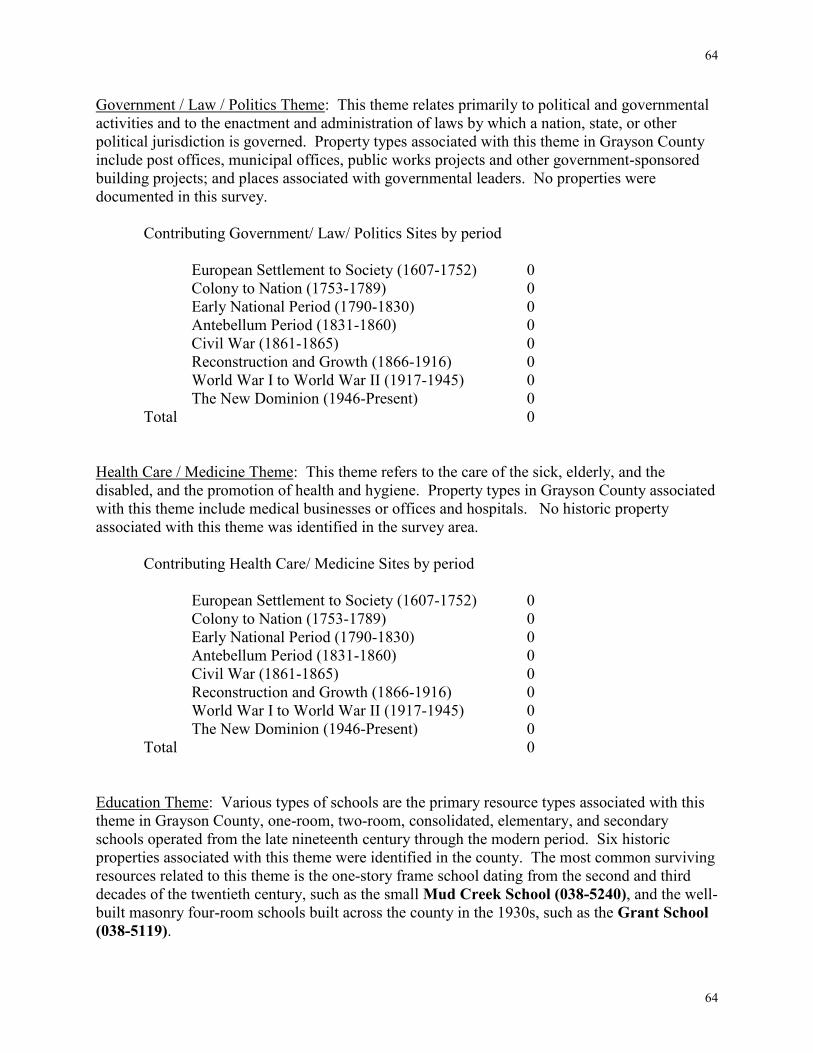
64
64
Government / Law / Politics Theme: This theme relates primarily to political and governmental activities and to the enactment and administration of laws by which a nation, state, or other political jurisdiction is governed. Property types associated with this theme in Grayson County include post offices, municipal offices, public works projects and other government-sponsored building projects; and places associated with governmental leaders. No properties were documented in this survey.
Contributing Government/ Law/ Politics Sites by period
European Settlement to Society (1607-1752) 0 Colony to Nation (1753-1789) 0 Early National Period (1790-1830) 0 Antebellum Period (1831-1860) 0 Civil War (1861-1865) 0 Reconstruction and Growth (1866-1916) 0 World War I to World War II (1917-1945) 0 The New Dominion (1946-Present) 0
Total 0 Health Care / Medicine Theme: This theme refers to the care of the sick, elderly, and the disabled, and the promotion of health and hygiene. Property types in Grayson County associated with this theme include medical businesses or offices and hospitals. No historic property associated with this theme was identified in the survey area.
Contributing Health Care/ Medicine Sites by period
European Settlement to Society (1607-1752) 0 Colony to Nation (1753-1789) 0 Early National Period (1790-1830) 0 Antebellum Period (1831-1860) 0 Civil War (1861-1865) 0 Reconstruction and Growth (1866-1916) 0 World War I to World War II (1917-1945) 0 The New Dominion (1946-Present) 0
Total 0 Education Theme: Various types of schools are the primary resource types associated with this theme in Grayson County, one-room, two-room, consolidated, elementary, and secondary schools operated from the late nineteenth century through the modern period. Six historic properties associated with this theme were identified in the county. The most common surviving resources related to this theme is the one-story frame school dating from the second and third decades of the twentieth century, such as the small Mud Creek School (038-5240), and the well-built masonry four-room schools built across the county in the 1930s, such as the Grant School (038-5119).
65
65
Contributing Education Sites by period
European Settlement to Society (1607-1752) 0 Colony to Nation (1753-1789) 0 Early National Period (1790-1830) 0 Antebellum Period (1831-1860) 1 Civil War (1861-1865) 0 Reconstruction and Growth (1866-1916) 1 World War I to World War II (1917-1945) 4 The New Dominion (1946-Present) 0
Total 6 Military / Defense Theme: The Southwest Virginia region includes properties with above- and below-ground resources directly associated with the 1760s French and Indian War, the American Revolution, the Civil War, and indirectly associated with the First and Second World Wars, the Korean Conflict, and the Vietnam War. Few related resource types are located in the county.
Contributing Military/ Defense Sites by period
European Settlement to Society (1607-1752) 0 Colony to Nation (1753-1789) 0 Early National Period (1790-1830) 0 Antebellum Period (1831-1860) 0 Civil War (1861-1865) 0 Reconstruction and Growth (1866-1916) 0 World War I to World War II (1917-1945) 0 The New Dominion (1946-Present) 0
Total 0 Social Theme: This theme relates to social activities and institutions, the activities of charitable, fraternal, or other community organizations and places associated with broad social movements. Property types in Grayson County associated with this theme include meeting halls and community centers. One historic property associated with this theme was documented for the survey project: the Mt. Zion Baptist Church (038-5188), which originally contained the meeting room of the Odd Fellows Lodge utilized by the black citizens of the area around Independence.
Contributing Social Sites by period
European Settlement to Society (1607-1752) 0 Colony to Nation (1753-1789) 0 Early National Period (1790-1830) 0 Antebellum Period (1831-1860) 0
66
66
Civil War (1861-1865) 0 Reconstruction and Growth (1866-1916) 1 World War I to World War II (1917-1945) 0 The New Dominion (1946-Present) 0
Total 1 Recreation / Arts Theme: This theme relates to the arts and cultural activities and institutions associated with leisure time and recreation. It encompasses the activities related to the popular and the academic arts including fine arts and the performing arts, literature, recreational gatherings, entertainment and leisure activity, and broad cultural movements. Property types in Grayson County that related to this theme in historic periods included theaters, gymnasiums, swimming pools, tennis courts, playing fields, playgrounds, and fairgrounds. One historic property associated with this theme has been documented in the county: The Fries Recreation Center (220-5001).
Contributing Recreation/ Arts Sites by period
European Settlement to Society (1607-1752) 0 Colony to Nation (1753-1789) 0 Early National Period (1790-1830) 0 Antebellum Period (1831-1860) 0 Civil War (1861-1865) 0 Reconstruction and Growth (1866-1916) 1 World War I to World War II (1917-1945) 0 The New Dominion (1946-Present) 0
Total 1
Transportation / Communication Theme: This theme relates to the process and technology of conveying passengers, materials, and information. Property types associated with transportation and communication networks in Grayson County have historically included rail-related resources (railroads, passenger and freight stations, engine houses, trains, and bridges), road-related resources (roads, turnpikes, taverns, automobiles, bridges, service stations, and automobile dealerships), and pedestrian-related resources (sidewalks and trails). Among the properties identified in the county that relate to the theme are the mid-nineteenth-century Raleigh Tavern/Delp Hotel (038-5137) in Elk Creek: the ca. 1940 Green Gables Service Station (038-5186) and two others like it, the Fields Motor Company (038-5201) in Mouth of Wilson, and numerous bridges located in previous survey efforts. Railroad-related resources are rare.
Contributing Transportation/ Communication Sites by period European Settlement to Society (1607-1752) 0 Colony to Nation (1753-1789) 0 Early National Period (1790-1830) 0 Antebellum Period (1831-1860) 1
67
67
Civil War (1861-1865) 0 Reconstruction and Growth (1866-1916) 0 World War I to World War II (1917-1945) 4 The New Dominion (1946-Present) 0
Total 5 Commerce / Trade Theme: This theme relates to the process of trading goods, services, and commodities. Property types in Grayson County historically associated with the theme include office buildings, stores, and banks; these resources housed various businesses, general stores, specialty stores, and the offices of professional, organizational, and financial institutions. Historically significant commercial buildings include the brick Farmers Bank of Elk Creek (038-5225) and the traditional commercial buildings in Independence, Troutdale, and in smaller communities that housed general stores, restaurants, furniture, hardware, grocery, and clothing stores. The frame general store at Comer’s Rock (038-5157) is a good example of rural commercial building. Troutdale and Whitetop contain several important commercial buildings dating from the lumber boom in the early twentieth century, such as the Frame Store (038-5242) at Whitetop. The brick Wilson’s Store (038-5179) and the brick commercial building in Independence (240-0008) are rare evidences of a brick commercial idiom in the county. The second largest number of buildings identified in the study area (13) are associated with this theme:
Contributing Commerce/ Trade Sites by period
European Settlement to Society (1607-1752) 0 Colony to Nation (1753-1789) 0 Early National Period (1790-1830) 0 Antebellum Period (1831-1860) 0 Civil War (1861-1865) 0 Reconstruction and Growth (1866-1916) 9 World War I to World War II (1917-1945) 4 The New Dominion (1946-Present) 0
Total 13 Industry / Processing / Extraction Theme: This theme explores the technology and process of managing materials, labor, and equipment to produce goods and services. Property types in the Grayson County region historically associated with this theme include quarries, mills (grist, textile, and woodworking), factories, power plants, tanneries, village shops, other small crafts and industrial sites, and mines. Two historic grist mills were documented in the survey area from the later nineteenth century: the Brookside Mill (038-0009) on the Saddle Creek and the Taylor’s Mill (038-5162). The small community of frame houses built for workers at the Fields Manufacturing Company in Mouth of Wilson (038-5203) and the company town at Fries are powerful examples of local rise of industrialism in the early twentieth century and the architectural adaptations required to make it work. Fries houses include the Boarding House (220-5002) and the management houses, such as the Stewart House (220-5003).
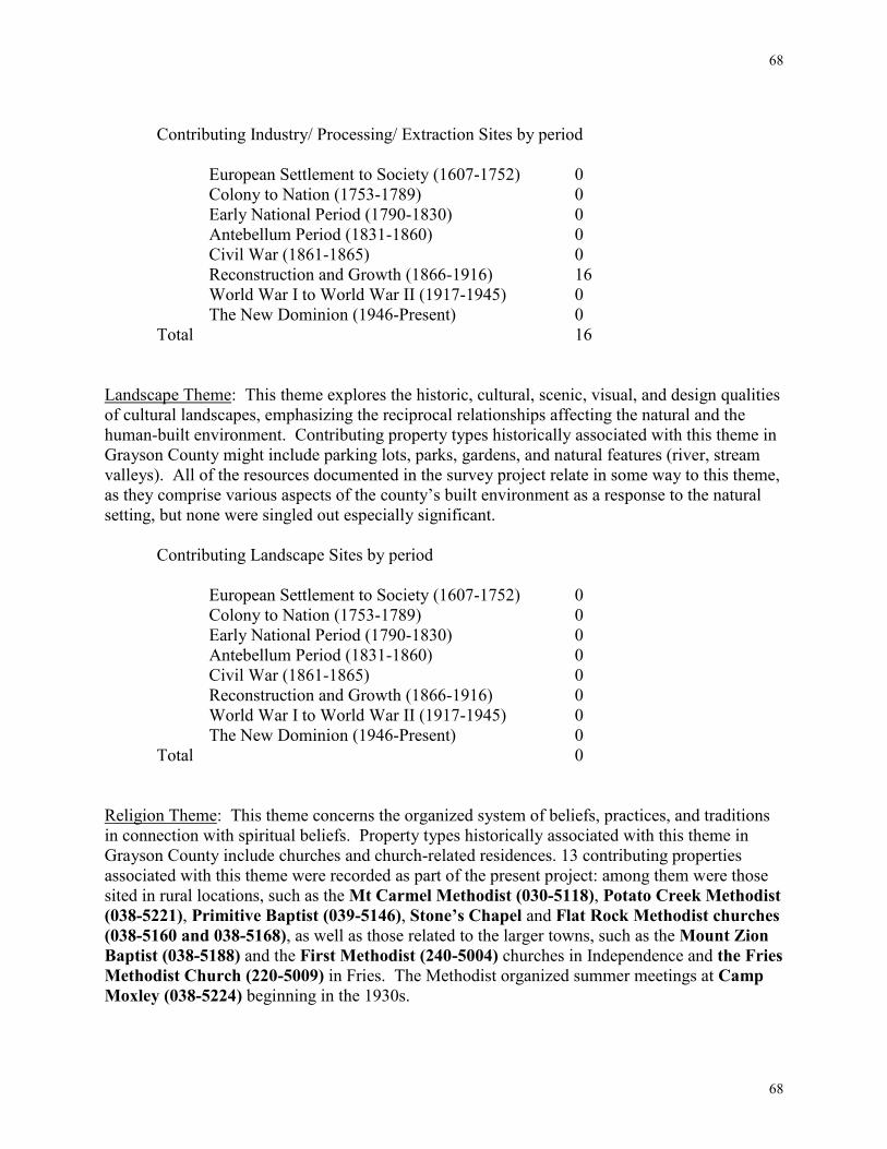
68
68
Contributing Industry/ Processing/ Extraction Sites by period
European Settlement to Society (1607-1752) 0 Colony to Nation (1753-1789) 0 Early National Period (1790-1830) 0 Antebellum Period (1831-1860) 0 Civil War (1861-1865) 0 Reconstruction and Growth (1866-1916) 16 World War I to World War II (1917-1945) 0 The New Dominion (1946-Present) 0
Total 16 Landscape Theme: This theme explores the historic, cultural, scenic, visual, and design qualities of cultural landscapes, emphasizing the reciprocal relationships affecting the natural and the human-built environment. Contributing property types historically associated with this theme in Grayson County might include parking lots, parks, gardens, and natural features (river, stream valleys). All of the resources documented in the survey project relate in some way to this theme, as they comprise various aspects of the county’s built environment as a response to the natural setting, but none were singled out especially significant.
Contributing Landscape Sites by period
European Settlement to Society (1607-1752) 0 Colony to Nation (1753-1789) 0 Early National Period (1790-1830) 0 Antebellum Period (1831-1860) 0 Civil War (1861-1865) 0 Reconstruction and Growth (1866-1916) 0 World War I to World War II (1917-1945) 0 The New Dominion (1946-Present) 0
Total 0 Religion Theme: This theme concerns the organized system of beliefs, practices, and traditions in connection with spiritual beliefs. Property types historically associated with this theme in Grayson County include churches and church-related residences. 13 contributing properties associated with this theme were recorded as part of the present project: among them were those sited in rural locations, such as the Mt Carmel Methodist (030-5118), Potato Creek Methodist (038-5221), Primitive Baptist (039-5146), Stone’s Chapel and Flat Rock Methodist churches (038-5160 and 038-5168), as well as those related to the larger towns, such as the Mount Zion Baptist (038-5188) and the First Methodist (240-5004) churches in Independence and the Fries Methodist Church (220-5009) in Fries. The Methodist organized summer meetings at Camp Moxley (038-5224) beginning in the 1930s.
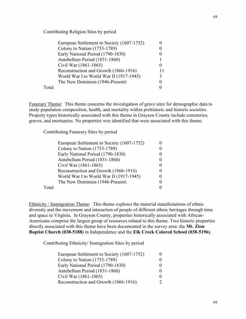
69
69
Contributing Religion Sites by period
European Settlement to Society (1607-1752) 0 Colony to Nation (1753-1789) 0 Early National Period (1790-1830) 0 Antebellum Period (1831-1860) 1 Civil War (1861-1865) 0 Reconstruction and Growth (1866-1916) 11 World War I to World War II (1917-1945) 3 The New Dominion (1946-Present) 0
Total 0 Funerary Theme: This theme concerns the investigation of grave sites for demographic data to study population composition, health, and mortality within prehistoric and historic societies. Property types historically associated with this theme in Grayson County include cemeteries, graves, and mortuaries. No properties wee identified that were associated with this theme.
Contributing Funerary Sites by period
European Settlement to Society (1607-1752) 0 Colony to Nation (1753-1789) 0 Early National Period (1790-1830) 0 Antebellum Period (1831-1860) 0 Civil War (1861-1865) 0 Reconstruction and Growth (1866-1916) 0 World War I to World War II (1917-1945) 0 The New Dominion (1946-Present) 0
Total 0 Ethnicity / Immigration Theme: This theme explores the material manifestations of ethnic diversity and the movement and interaction of people of different ethnic heritages through time and space in Virginia. In Grayson County, properties historically associated with African-Americans comprise the largest group of resources related to this theme. Two historic properties directly associated with this theme have been documented in the survey area: the Mt. Zion Baptist Church (038-5188) in Independence and the Elk Creek Colored School (038-5196).
Contributing Ethnicity/ Immigration Sites by period
European Settlement to Society (1607-1752) 0 Colony to Nation (1753-1789) 0 Early National Period (1790-1830) 0 Antebellum Period (1831-1860) 0 Civil War (1861-1865) 0 Reconstruction and Growth (1866-1916) 2
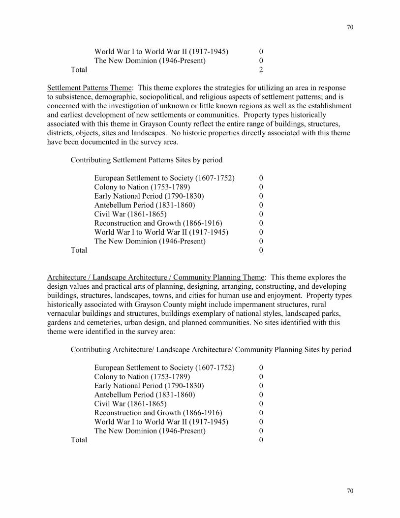
70
70
World War I to World War II (1917-1945) 0 The New Dominion (1946-Present) 0
Total 2 Settlement Patterns Theme: This theme explores the strategies for utilizing an area in response to subsistence, demographic, sociopolitical, and religious aspects of settlement patterns; and is concerned with the investigation of unknown or little known regions as well as the establishment and earliest development of new settlements or communities. Property types historically associated with this theme in Grayson County reflect the entire range of buildings, structures, districts, objects, sites and landscapes. No historic properties directly associated with this theme have been documented in the survey area.
Contributing Settlement Patterns Sites by period
European Settlement to Society (1607-1752) 0 Colony to Nation (1753-1789) 0 Early National Period (1790-1830) 0 Antebellum Period (1831-1860) 0 Civil War (1861-1865) 0 Reconstruction and Growth (1866-1916) 0 World War I to World War II (1917-1945) 0 The New Dominion (1946-Present) 0
Total 0 Architecture / Landscape Architecture / Community Planning Theme: This theme explores the design values and practical arts of planning, designing, arranging, constructing, and developing buildings, structures, landscapes, towns, and cities for human use and enjoyment. Property types historically associated with Grayson County might include impermanent structures, rural vernacular buildings and structures, buildings exemplary of national styles, landscaped parks, gardens and cemeteries, urban design, and planned communities. No sites identified with this theme were identified in the survey area:
Contributing Architecture/ Landscape Architecture/ Community Planning Sites by period
European Settlement to Society (1607-1752) 0 Colony to Nation (1753-1789) 0 Early National Period (1790-1830) 0 Antebellum Period (1831-1860) 0 Civil War (1861-1865) 0 Reconstruction and Growth (1866-1916) 0 World War I to World War II (1917-1945) 0 The New Dominion (1946-Present) 0
Total 0
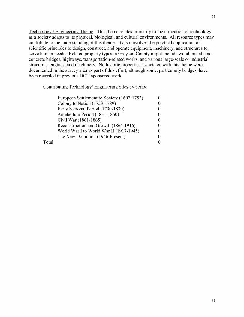
71
71
Technology / Engineering Theme: This theme relates primarily to the utilization of technology as a society adapts to its physical, biological, and cultural environments. All resource types may contribute to the understanding of this theme. It also involves the practical application of scientific principles to design, construct, and operate equipment, machinery, and structures to serve human needs. Related property types in Grayson County might include wood, metal, and concrete bridges, highways, transportation-related works, and various large-scale or industrial structures, engines, and machinery. No historic properties associated with this theme were documented in the survey area as part of this effort, although some, particularly bridges, have been recorded in previous DOT-sponsored work.
Contributing Technology/ Engineering Sites by period
European Settlement to Society (1607-1752) 0 Colony to Nation (1753-1789) 0 Early National Period (1790-1830) 0 Antebellum Period (1831-1860) 0 Civil War (1861-1865) 0 Reconstruction and Growth (1866-1916) 0 World War I to World War II (1917-1945) 0 The New Dominion (1946-Present) 0
Total 0
72
72
RESEARCH DESIGN Introduction
This historic architecture survey was conducted from winter of 2001 to spring of 2002 to identify and document approximately one hundred (100) properties in Grayson County to the reconnaissance level and ten (10) to the intensive level. This was extended in the fall of 2001 to an additional fifty reconnaissance and five intensive sites. When completed the survey comprised a total of one hundred and sixty-five (165) primary resources. Methodology
Fieldwork, which involved vehicular and pedestrian reconnaissance of the county and the towns within it, was preceded by reviews of primary and secondary sources in order to identify historic building types and individual building histories. All properties were documented to the reconnaissance level according to DHR standards. For each of the surveyed properties, the contractor took 35mm black and white photographs, noted exterior architectural features, stated potential significance, and prepared a sketch plan of the site. If owners or other informants were available, Worsham gathered limited historic background on the properties. Where possible, interiors were accessed with the occupants' permission (a sketch of the floor plan was prepared for those properties). Limited historic research and oral history interviews supplemented the fieldwork to provide contextual information on individual properties.
Following field recording efforts, processing of materials and preparation of site files was begun. Site information was recorded in DHR's information database, DSS. Upon completion of data entry, the final report, with recommendations for future survey, register, and planning activities, was prepared, including an historic overview of the county’s architectural development, and brief discussions of eighteen DHR-defined historic themes with descriptions of relevant property types and lists of associated properties. Appendices include DSS-generated alphabetical and numerical inventories of surveyed properties.
Printouts of the computerized survey files have been placed in acid-free envelopes along with original photographs and other materials. The original files and a copy of the survey report are stored in the DHR Archives in Richmond, Virginia. Photocopies of these materials, plus the original field notes, are stored at RRPO, 1030 Penmar Avenue, SE, Roanoke, VA. Additional photocopies of the survey files and report will be provided to the county. Copies of the report also will be available in the Wythe/Grayson Regional Library. Expected Results
The investigators anticipated the findings detailed below in part from a wide familiarity with the region from numerous survey projects and from preliminary historic research.
73
73
SURVEY FINDINGS
One hundred and sixty-five buildings were surveyed in Grayson County as part of this project, which brings the total number of surveyed sites in Grayson County to 438. This represents as little as half of what a comprehensive survey should ultimately include in Grayson County.
The areas along St. Rt. 58 through the county are targeted as areas of commercial and industrial growth where historic resources would be affected by future development. The survey information, which includes a statement of potential significance, should be consulted in future planning efforts for these areas in particular.
The survey produced results indicating the high survival rate of important resources, chiefly dwellings and commercial buildings, related to the growth and expansion of the county in the years after the Civil War as an important agricultural and industrial region. It is expected that commercial development will continue unabated in rural areas along highways for the foreseeable future. Under the present planning and zoning system there will undoubtedly be erosion of the quality and number of surveyed commercial buildings and dwellings. EVALUATION
The buildings surveyed were selected based on a need for representation across all relevant time periods and themes as identified by the Department of Historic Resources. Each property was evaluated against defined historic contexts, registration criteria, and periods and areas of significance. Potential Historic Designation The Virginia Landmarks Register provides for the recognition of significant state historic landmarks and for the review of effects that state-funded or permitted projects might have on registered landmarks. Occasionally, state funding is available to properties listed on or eligible for the Virginia Landmarks Register. State tax credits have recently become available for rehabilitation of residential and income-producing properties. The National Register of Historic Places is a federal designation that honors a property by recognizing its importance to its community, state or the Nation. Owners of listed property may be able to obtain Federal historic preservation funding, when funds are available. In addition, Federal investment tax credits for rehabilitation and other provisions may apply. Federal agencies whose projects affect a listed or eligible property must consult with the State Historic Preservation Officer and the Advisory Council on Historic Preservation to try and minimize any harmful effects of the project upon the historic property.
74
74
Eligibility Standards The National Park Service has developed a set of standards, the National Register Criteria
for Evaluation, by which properties nominated to the National Register of Historic Places (NRHP) are evaluated. These Criterion are set forth in National Register Bulletin 15: How to Apply the National Register Criteria for Evaluation. In order to qualify for listing on the National Register, a property or district must be determined to be significant through its association with an important historic context and it must retain its historic integrity. Significance
In order for a property or district to be considered for National Register listing, it must be shown to be significant for one or more of the four NRHP Criterion for Evaluation. Significance of a property or district is determined through its association with an important historic context (historical pattern). Historic contexts relate to the eighteen historic themes developed by DHR: domestic, subsistence/agriculture, government/law/political, health care/medicine, education, military/defense, religion, social, recreation and the arts, transportation/communication, commerce/trade, industry/processing/extraction, landscape, funerary, ethnicity/immigration, settlement patterns, architecture/landscape architecture/community planning, and technology/engineering. Properties/districts can be determined to be significant within more than one historic context. It can also be deemed significant on one or more geographic level (i.e. local, state, national).
The criterion describes how properties/districts are significant for their association with important events or persons (Criterion A and B), for their importance in design or construction (Criterion C), or for their information potential (Criterion D) (U.S. Department of the Interior, 1991). The following is a brief description of each of the four NRHP Criterion for Evaluation (excerpted from National Register Bulletin 15: How to Apply the National Register Criteria for Evaluation): Criterion A: Event
Properties can be eligible for the National Register if they are associated with events that have made a significant contribution to the broad patterns of our history.
Types of Events A specific event marking an important moment in American prehistory or history. A pattern of events or a historic trend that made a significant contribution to the development of a community, a state, or the nation.
Association of the Property with the Event
The property must be documented to have existed at the time of the event or pattern of events and to have been associated with those events. A property is not eligible if its associations are speculative.
Significance of the Association
Mere association with historic events or trends is not enough, in and of itself, to qualify under Criterion A. The property’s specific association must be considered
75
75
important as well. Criterion B: Person
Properties may be eligible for the National Register if they are associated with the lives of persons significant in our past.
Significance of the Individual The persons associated with the property must be individually significant within an historic context. A property is not eligible if its only justification for significance is that it was owned or used by a person who is a member of an identifiable profession, class, or social or ethnic group. It must be shown that the person gained importance within his or her profession or group.
Association with the Property
Properties eligible under Criterion B are usually those associated with a person’s productive life, reflecting the time period when he or she achieved significance. The individual’s association with the property must be documented. Speculative associations are not acceptable. Properties associated with living persons are usually not eligible for inclusion in the National Register.
Criterion C: Design/Construction
Properties may be eligible for the National Register if they embody the distinctive characteristics of a type, period, or method of construction, or that represent the work of a master, or that possess high artistic values, or that represent a significant and distinguishable entity whose components may lack individual distinction. Resources that represent a significant and distinguishable entity whose components may lack individual distinction, districts, are defined within the context of this criterion. Districts must be an unified entity and possess a significant concentration, linkage, or continuity of sites, buildings, structures, or objects united historically or aesthetically by plan or physical development (U.S. Department of the Interior, 1991:5).
Distinctive Characteristics of Types, Periods, and Methods of Construction To be eligible under this portion of the criterion, a property must clearly illustrate, through “distinctive characteristics,” the following:
The pattern of features common to a particular class of resources, The individuality or variation of features that occurs within the class, The evolution of that class, or The transition between classes of resources.
Work of a Master A master is a figure of generally recognized greatness in a field, a known craftsman of consummate skill, or an anonymous craftsman whose work is distinguishable from others by its characteristic style and quality. The property must express a particular phase in the development of the master’s career, an aspect of his or her work, or a particular idea or theme in his or her craft. A
76
76
property is not eligible as the work of a master, however, simply because it was designed by a prominent architect.
Properties Possessing High Artistic Values
High artistic values may be expressed in many ways, including areas as diverse as community design or planning, engineering, and sculpture. A property is eligible for its high artistic values if it so fully articulates a particular concept of design that it expresses an aesthetic ideal. A property is not eligible, however, if it does not express aesthetic ideals or design concepts more fully than other properties of its type.
Criterion D: Information Potential
Properties may be eligible for the National Register if they have yielded, or may be likely to yield, information important in prehistory or history.
Archeological Sites Criterion D most commonly applies to properties that contain or are likely to contain information bearing on an important archeological research question.
Buildings, Structures, and Objects Criterion D can also apply to buildings, structures, and objects that contain important information. In order for these types of properties to be eligible under Criterion D, they themselves must be, or must have been, the principal source of the important information.
Integrity
Integrity is the ability of a property or district to convey its significance. To be listed in the National Register of Historic Places, a property/district must not only be shown to be significant under the National Register Criteria, but it also must have integrity. The National Register Criteria recognizes seven aspects that define integrity. The aspects are: location, design, setting, materials, workmanship, feeling, and association (U.S. Department of the Interior, 1991). The following is a brief description of each of the seven aspects of integrity (excerpted from National Register Bulletin 15: How to Apply the National Register Criterion for Evaluation):
Location- the place where the historic property was constructed or the place where the historic event occurred.
Design- the combination of elements that create the form, plan, space, structure, and style of a property. It results from conscious decisions made during the original conception and planning of a property (or its significant alteration) and applies to activities as diverse as community planning, engineering, architecture, and landscape architecture. Design includes such elements as organization of space, proportion, scale, technology, ornamentation, and materials.
77
77
Setting- the physical environment of a historic property. Setting refers to the character of the place in which the property played its historical role. It involves how, not just where, the property is situated and its relationship to surrounding features and open space.
Materials- the physical elements that were combined or deposited during a particular period of time and in a particular pattern or configuration to form an historic property.
Workmanship- the physical evidence of the crafts of a particular culture or people during any given period in history or prehistory.
Feeling- a property’s expression of the aesthetic or historic sense of a particular time period.
Association- the direct link between an important historic event or person and an historic property.
Properties Eligible for National Register Listing
As a part of the survey, fifteen properties were selected to be surveyed on an intensive level. Some of these were thought to be potentially eligible for listing in the Virginia Landmarks Register and the National Register of Historic Places. The intensive level survey includes a statement of significance that includes an evaluation, a discussion of the properties integrity as well as recommended boundaries for the property. At the conclusion of the project, the following properties were presented for review to the DHR National Register Evaluation Team and determined eligible for listing on the National Register.
The following buildings and districts will be presented for determination of eligibility for listing on the National Register by the DHR Staff Evaluation Team. Individual properties Historic districts
As a result of the survey, additional properties were identified that may be potentially eligible for individual National Register listing pending further investigation and/or intensive-level survey. The following properties are recommended for further study:
Individual Properties
p. 77 Setting- the physical environment of a historic property. Setting refers to the character of the place in which the property played its historical role. It involves how, not just where, the property is situated and its relationship to surrounding features and open space.
Materials- the physical elements that were combined or deposited during a particular period of time and in a particular pattern or configuration to form an historic property.
Workmanship- the physical evidence of the crafts of a particular culture or people during any given period in history or prehistory.
Feeling- a property’s expression of the aesthetic or historic sense of a particular time period.
Association- the direct link between an important historic event or person and an historic property.
Properties Eligible for National Register Listing
As a part of the survey, fifteen properties were selected to be surveyed on an intensive level. Some of these were thought to be potentially eligible for listing in the Virginia Landmarks Register and the National Register of Historic Places. The intensive level survey includes a statement of significance that includes an evaluation, a discussion of the properties integrity as well as recommended boundaries for the property. At the conclusion of the project, the following properties were presented for review to the DHR National Register Evaluation Team and determined eligible for listing on the National Register.
The following buildings and districts were presented for determination of eligibility for listing on the National Register by the DHR Staff Evaluation Team. Individual properties Eli Hale House, Grayson Co., DHR File Number 038-0003.
This resource was evaluated as locally significant under Criterion C (Architecture) with a POS of 1854-1940; the committee recommends that the resource is eligible for individual listing with 37 points. The resource was previously evaluated on 2 September 1976 and was found not eligible.
Brookside Mill, Grayson Co., DHR File Number 038-0009.
This resource, which includes an early service station, was evaluated as locally significant under Criteria A (Industry), C (Architecture) and D (Archaeology) with a POS of 1870-1930; the committee recommends that the resource is eligible
for listing with 41 points. The resource was previously evaluated on 29 April 1999 for local significance under Criteria A (Industry) and C (Architecture), was found eligible with a score of 41 points.
William Bourne House, Grayson Co., DHR File Number 038-0010.
This resource was evaluated as locally significant under Criteria A (Broad Patterns of History) and C (Architecture) with a POS of 1790-1930; the committee recommends that the resource is potentially eligible for listing with 38 points.
Stephen Bourne House (Bourne-Hale House), Grayson Co., DHR File Number 038-
0018. This resource had been evaluated as the Bourne-Hale House on 1 May 2003 as locally significant under Criteria C (Architecture) and the committee had recommended that it was eligible for listing with 34 points
Edgewater-Young House, Grayson Co., DHR File Number 038-5121.
This resource was evaluated as locally significant under Criteria A (Broad Patterns of History) and C (Architecture) with a POS of 1908-1950; the committee recommends that the resource is eligible for individual listing with 33 points.
Ira Cebert Hash House, Grayson Co., DHR File Number 038-5190.
This resource was evaluated as locally significant under Criterion C (Architecture) with a POS of 1902-1930; the committee recommends that the resource is eligible for individual listing with 36 points.
Pierce-Parsons House, Grayson Co., DHR File Number 038-5198.
This resource was evaluated as locally significant under Criterion C (Architecture) with a POS of 1884-1930; the committee recommends that the resource is eligible for individual listing with 31 points.
Boyden Cox House, Grayson Co., DHR File Number 038-5129.
This resource was evaluated as locally significant under Criterion C (Architecture) with a POS of 1880-1920; the committee recommends that the resource is potentially eligible for individual listing with 33 points.
Company House, Fries, Grayson Co., DHR File Number 220-5002.
This resource was evaluated as locally significant under Criteria A (Industry) and C (Architecture) with a POS of 1908-1950; the committee recommends that the resource is eligible for individual listing with 37 points.
Jesse Cox House, Grayson Co., DHR File Number 038-5189.
This resource was evaluated as locally significant under Criterion C (Architecture) with a POS of 1850-1920; the committee recommends that the resource is eligible for individual listing with 33 points.
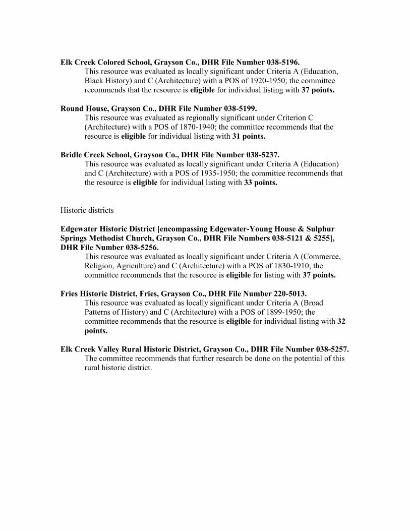
Elk Creek Colored School, Grayson Co., DHR File Number 038-5196.
This resource was evaluated as locally significant under Criteria A (Education, Black History) and C (Architecture) with a POS of 1920-1950; the committee recommends that the resource is eligible for individual listing with 37 points.
Round House, Grayson Co., DHR File Number 038-5199.
This resource was evaluated as regionally significant under Criterion C (Architecture) with a POS of 1870-1940; the committee recommends that the resource is eligible for individual listing with 31 points.
Bridle Creek School, Grayson Co., DHR File Number 038-5237.
This resource was evaluated as locally significant under Criteria A (Education) and C (Architecture) with a POS of 1935-1950; the committee recommends that the resource is eligible for individual listing with 33 points.
Historic districts
Edgewater Historic District [encompassing Edgewater-Young House & Sulphur Springs Methodist Church, Grayson Co., DHR File Numbers 038-5121 & 5255], DHR File Number 038-5256.
This resource was evaluated as locally significant under Criteria A (Commerce, Religion, Agriculture) and C (Architecture) with a POS of 1830-1910; the committee recommends that the resource is eligible for listing with 37 points.
Fries Historic District, Fries, Grayson Co., DHR File Number 220-5013.
This resource was evaluated as locally significant under Criteria A (Broad Patterns of History) and C (Architecture) with a POS of 1899-1950; the committee recommends that the resource is eligible for individual listing with 32 points.
Elk Creek Valley Rural Historic District, Grayson Co., DHR File Number 038-5257. The committee recommends that further research be done on the potential of this rural historic district.

78
78
79
79
PRESERVATION RECOMMENDATIONS Future Survey and Documentation Efforts
Since this project was limited to one hundred and sixty-five properties, it necessarily excluded many historic resources (those fifty years of age or older) that remain within the county. A comprehensive survey is necessary to document a more complete range of property types that represent all of Grayson’s historic themes and time periods. In addition, more intensive surveys for important buildings already examined could be undertaken. Preservation Planning Recommendations
Grayson County presently has a few individual properties listed in the Virginia Landmarks Register and the National Register of Historic Places. Several historic districts are proposed. The zoning ordinance should contain the provision allowing historic overlay ordinances to be locally established that would protect specific historic properties. Architectural review boards could be set up in the current and proposed individual districts to set standards for work.
The next step in preserving the county’s historic resources should be to prepare a preservation plan involving extensive participation and collaboration between the county and town governments, local preservation advocates, owners of historic properties, the Planning District Commission, and other interested citizens, business interests, preservationists, and planners. The preservation planning process should be inclusive and comprehensive in nature, should integrate the findings of this and future survey efforts into the policy-making procedures of the county, and should meet state and national standards for historic preservation as well as the needs of the community. Survey data can be utilized as a means for the community to identify opportunities for conservation of the essential elements which give the rural and urban districts their historic character, to reduce potential conflicts between preservation and development forces, and to resolve any such disputes in an orderly and productive manner. It would serve the county by integrating historic preservation with economic development, heritage tourism, education, conservation, and community development efforts. Establish Rural Historic Districts
In many instances, Grayson County’s rural landscape and settlement patterns have remained relatively unchanged. Establishment of a rural historic district in the Elk Creek area identified as potentially eligible (038-5257), will help to preserve the traditional character of the county with its unique landscape. Other rural areas for consideration would be the area around Edgewater (038-5121) near Mouth of Wilson, Spring Valley, and the rural area surrounding the Brookside Mill (038-0009) and the Saddle Creek Primitive Baptist Church (038-5193).
80
80
Education
Develop a local history curriculum in the local schools that incorporates information available through DHR and the community’s historic preservation groups. It should be recognized that an understanding of the architectural and historic resources within the county is essential to the proper and successful stewardship of these resources and the heritage they represent. An educational curriculum should be devised that uses field trips to take advantage of the local resources. Tourism
It is recommended that Grayson County continue to develop and coordinate special events that combine the natural resources of the County with the historic and prehistoric resources to promote tourism as well as a greater understanding and appreciation of the county’s heritage.
81
81
GLOSSARY American bond: a brick pattern involving regular courses of stretchers with occasional bond courses of headers. Architrave: a door, mantel, or windows frame in the form of a board with moldings projecting gradually out to a
culminating outer molding. Ashlar: Hewn or squared stone. Baseboard: a mopboard at the bottom of the wall, often the lowest element in a wainscot or plastered wall. Batten door: a door made up of vertical boards fastened together by two or three horizontal battens on the rear. Bay: the openings, whether doors or windows, in a facade. Bead: a small curved molding along the edge of a board. Bed mold: the bottom molded element in a classical cornice. Bolection molding: a molding with a projecting central element flanked above and below by receding moldings,
often symmetrically placed. Bulkhead: a low sloping doorway resting on masonry side walls that covers a below grade basement entry. Bungalow: Usually a one ½-story house of irregular, functional floor plan with a deep gable roof and a dormer on
the front and rear. A porch usually is placed across the front of the house and is covered by an extension of the roof. An “American Foursquare” house is a two story version of the bungalow. The bungalow is a nationally popular house form associated with publications of the Craftsman design movement.
Cavetto molding: an inward curving molding. Center-passage plan: A house plan in which a central entrance hall is flanked by a room on each side. Chair rail: a board running around a room, usually carrying a molding and often at about window sill height,
sometimes forming the top of a wainscot. Circular sawn: Sawn by a mechanical saw with circular blade that leaves curved marks. Clapboard: riven or split board used to sheath walls and roofs, lapped and attached horizontally to a frame building
to shed rain. Clipped gable: A gable roof with the top of the gable end hipped. Collar beam: part of a roof framing system the ties the rafters together just below the apex, to prevent the rafters
from spreading, to which the ceiling of a garret is sometimes attached. Common rafters: the slender, usually principal roof members with their feet on the plate and usually lapped and
pinned to each other at the apex. Corbelling: Brick or masonry work in courses built with one row projecting slightly beyond the other to create a
stacked effect, like a series of corbels. Cornice: the highest member of a classical composed facade, often the only classical feature of a house, it usually
spans a wall just below the roof and is made up of classical moldings that project out to the roof edge.
82
82
Craftsman: The Craftsman style became popular in the early-20th century. It began as an American extension of the British Arts and Crafts movement that was a reaction against the mass-production associated with the Industrial Revolution. It championed traditional handicrafts and natural materials. In this region, it principal manifestation was in the detailing applied to the 1-1/2 story bungalow house form. Characteristics of the style include: a mixture of natural materials, such as stone, wood shingles, stucco, and cobblestones; gently-pitched broad gable roofs with dormers and exposed rafters; porches supported by battered columns on piers; and multi-paned window and door glazing in a variety of geometric shapes.
Crown mold: the top molded element in a classical cornice. Cyma molding: and outward curving molding in the classical order. Dentils: regular tooth-like projections which run along a more elaborate classical molding. Double-pile: a house with two ranges of rooms arranged one behind the other. Down braces: Members of a frame building that are angled from the sill to a vertical post to give rigidity to the
frame. End board: the small wood element closing a cornice at a building’s gable end, sometimes sawn in an ornamental
curve to correspond to the cornice profile. English bond: a brick pattern made up of alternating courses of headers and stretchers. Entablature: in classical architecture, the part of a structure between the column capital and the roof, comprising the
architrave, frieze, and cornice. Facade: a principal front of a building or other important architectural elevation. Federal: The Federal style was the dominant style in the United States from circa 1780 to the early-19th century. It
was a development and refinement of the earlier Georgian style based on more accurate studies of ancient Rome and Greece. Door and window openings are delicately scaled and articulated, often using fans and oval forms. Columns and moldings are slender and more delicate compared to the Georgian period. Mantels are often made up of pilasters supporting a full entablature with a projecting shelf/cornice. Architectural elements are sometimes detailed with rosettes, urns, swags, fans, and oval sunbursts.
Fillet: a square molding often used to divide curved elements. Flemish bond: a brick pattern made up of alternating stretchers and headers in an ornamental pattern. Fretwork: A geometrical ornament of vertical and horizontal lines repeated to form a band. Characteristic of the
Greek-Revival style, it is also known as a key pattern or meander. Frieze: the middle division of an entablature, between the cornice and the architrave. The decorated band along the
upper part of a wall below the cornice. Georgian: The period of the Georgian style in architecture generally refers to the early-18th century in the
American colonies. Based on Classical design principles of Rome, this English style came to the colonies through pattern books and immigrant artisans. As a departure from the earlier medieval architecture, this style is characterized by rigid symmetry, balanced proportions, and Classical detailing.
Glazed headers: a brick that has received special treatment in its firing to give it a shiny blue-black color, used to
ornament walls, often in Flemish bond and English bond walls.
83
83
Gothic Revival: style originating in Britain and imitating some elements of mediaeval architecture, often used for dwellings and churches from the mid-nineteenth century until well into the twentieth century. Characterized by pointed arches, grouped windows with heavy moldings, carved vergeboards, and spiky finials.
Grapevine joint: an incised groove in a mortar joint. Greek Revival: The Greek-Revival style became popular in the early 19th century as the young country wanted to
associate itself with the ideals of Greek democracy. It is often characterized by a columned portico and pedimented-gable roof that allude to the Greek temple. Other details associated with the style include bold, simple moldings, heavy cornices with a wide, unadorned frieze, horizontal transoms, and fretwork.
Hall-Chamber plan: A house plan in which two rooms of unequal size make up the first floor, the larger room often
serving as a principal living room and the other as a bed room. Head: the horizontal member at the top of a door or window. Header: the short end of a brick laid horizontally. Hewn: roughly flattened sides of a timber member. HL hinges: wrought iron hinges with the form of the letters H and L when seen from in front. Hood: a bracketed or cantilevered roof over a door. Italianate: The Italianate style was introduced to America through pattern books in the 1830s and dominated
architectural design through the mid-19th century. The most elaborate examples can resemble a picturesque Italian villa with towers and cupolas, or classically restrained as an urban Italian palazzo. As applied to the regional planning tradition, features include wide, overhanging eaves with cornice brackets, arched window and door openings with ornate hoods or surrounds, and grouped windows.
Jamb: the side members of a door or window. Joists: the principal members of a frame building to which the floor or ceiling is attached. L-shaped plan An intersecting gable house in the shape of an L. Lap joint: wood joint in which corresponding inset sections in two members are laid together. Lintel: a wooden or stone member spanning a door, window, or fireplace opening. Lock rail: the rail in a wooden panel door to which the lock is attached. Modillions: ornamental brackets used in series under the cornice in classical entablatures. Mortice-and-tenon: wood joint in which a projecting reduced end of a member is inserted into a corresponding hole
in another, often fixed in place with a peg or pin. Mortice lock: a lock inserted into a door frame. Muntin: the slender members separating and supporting the panes in a window. Ovolo molding: an outward curving molding, the same as a cyma. “Peg-and-slot:” colloquial term used to mean mortice-and-tenon.
84
84
Pilasters: engaged flat columns that form the vertical ends of a mantel and often serve to support the mantel shelf. Pinned: method of securing wood joints by means of a peg or pin inserted into round hole though the members. Pinrail: a wood member spanning a wall at mid-height, from which pictures, mirrors, or other objects might be
hung, sometimes from wooden pegs or pins. Pintles: iron hinge base for a door or shutter with a vertical post on which a shutter or door swings, either screwed to
a door or window jamb or driven into it. Pit-sawn: sawn by hand with a two-man saw, with one sawyer in a pit dug below the member being reduced,
characterized by slightly varying, nearly straight saw marks. Plates: the topmost horizontal members in the walls of a framed building. Posts: the principal vertical members in a framed building that carry the most weight, they usually forms the corners,
others are spaced at regular and flank the door and window openings. Press: a built-in cupboard or small closet. Queen Anne: The Queen Anne style became popular in the late-19th century and is closely associated with
industrial development as it made the mass-produced, scroll-sawn detail elements of the style widely available. It is characterized by an asymmetrical composition with a variety of forms, textures, materials, and colors, achieved through the use of towers, turrets, bays, tall chimneys, and wrap-around porches. Contrasting materials, decorative brickwork or wood siding and colored glass in the windows add to the texture. Scroll-sawn detailing, particularly in the porches, are a trademark of this style. In the Colonial Revival version of the style, classical detailing such as columns with capitals, dentils, Palladian-motif window and door openings were added to the asymmetrical Queen-Anne form.
Rail: the horizontal members in a panel door. Raised and fielded panels: wood paneling with a projecting central rectangular section. Reeding: parallel carved grooves that extend lengthwise in a pilaster or trim board. Rake board: the board that descends along the end edge of a roof. Ridge beam: a member at the apex of a roof that sometimes carry the upper rafter ends. Rimlock: a lock mounted on the face of a door and enclosed in a metal or wooden box. Scarf joint: a popular way of joining two lengths of timber into a single member. Segmental arch: an arch formed of a shallow arc or section of a true circle. Side-passage plan: a house plan in which a single room, often the principal entertaining room, is flanked on one side
by a passage or entrance hall. Sill: the lowest member of a framed building, laid on top of the foundation or spanning piers. Single-pile: a house with a single range of rooms arranged across the front. Split lath: the strips of wood mailed across the framing to hold plaster. When split rather than sawn, it has been split
along the grain of the wood from a larger piece. Stile: the vertical members in a wooden panel door.
85
85
Stoop: a place to stand outside of a door. Stretcher: the long side of a brick laid horizontally. Studs: the slender secondary vertical members in a frame building that carry the siding and lath. T-plan: A house shaped like a T, usually with the T-stem facing the front and the T-bar creating gabled projecting
elements on the front and rear. Usually provides three rooms per floor with or without a central passage. Torus: a projecting half-rounded element in a classical molding. Transom: a glazed panel set above a door to provide light on the interior, usually when there is no place for a
conventional window. Triglyph: a three-part carved element in a classical cornice. Vergeboard: A board, often ornately carved, attached to the end gables of a roof. Also called a bargeboard. Vernacular: a method of design in which local building traditions primarily guide the construction of buildings.
Although such buildings are not designed in the academic styles, they often incorporate details adapted from published sources.
Wainscoting: wood paneling around the lower part of a room. Weatherboard: siding made up of sawn boards attached horizontally to a frame building with the lower edges lapped
to shed rain. Wrought nails: Hand-made nails with a round-shaped head.
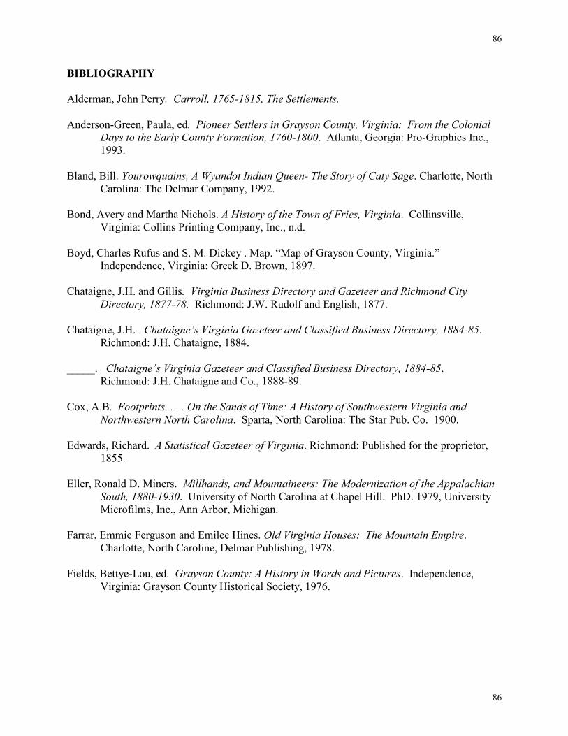
86
86
BIBLIOGRAPHY Alderman, John Perry. Carroll, 1765-1815, The Settlements. Anderson-Green, Paula, ed. Pioneer Settlers in Grayson County, Virginia: From the Colonial
Days to the Early County Formation, 1760-1800. Atlanta, Georgia: Pro-Graphics Inc., 1993.
Bland, Bill. Yourowquains, A Wyandot Indian Queen- The Story of Caty Sage. Charlotte, North
Carolina: The Delmar Company, 1992.
Bond, Avery and Martha Nichols. A History of the Town of Fries, Virginia. Collinsville, Virginia: Collins Printing Company, Inc., n.d.
Boyd, Charles Rufus and S. M. Dickey . Map. “Map of Grayson County, Virginia.”
Independence, Virginia: Greek D. Brown, 1897. Chataigne, J.H. and Gillis. Virginia Business Directory and Gazeteer and Richmond City
Directory, 1877-78. Richmond: J.W. Rudolf and English, 1877. Chataigne, J.H. Chataigne’s Virginia Gazeteer and Classified Business Directory, 1884-85. Richmond: J.H. Chataigne, 1884. _____. Chataigne’s Virginia Gazeteer and Classified Business Directory, 1884-85.
Richmond: J.H. Chataigne and Co., 1888-89. Cox, A.B. Footprints. . . . On the Sands of Time: A History of Southwestern Virginia and
Northwestern North Carolina. Sparta, North Carolina: The Star Pub. Co. 1900. Edwards, Richard. A Statistical Gazeteer of Virginia. Richmond: Published for the proprietor,
1855. Eller, Ronald D. Miners. Millhands, and Mountaineers: The Modernization of the Appalachian
South, 1880-1930. University of North Carolina at Chapel Hill. PhD. 1979, University Microfilms, Inc., Ann Arbor, Michigan.
Farrar, Emmie Ferguson and Emilee Hines. Old Virginia Houses: The Mountain Empire.
Charlotte, North Caroline, Delmar Publishing, 1978. Fields, Bettye-Lou, ed. Grayson County: A History in Words and Pictures. Independence, Virginia: Grayson County Historical Society, 1976.
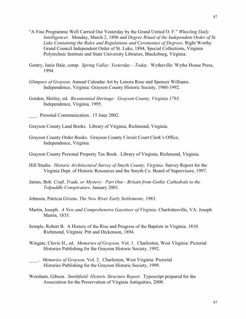
87
87
“A Fine Programme Well Carried Out Yesterday by the Grand United O. F.” Wheeling Daily Intelligencer. Monday, March 2, 1896 and Degree Ritual of the Independent Order of St. Luke Containing the Rules and Regulations and Ceremonies of Degrees. Right Worthy Grand Council Independent Order of St. Luke, 1894, Special Collections, Virginia Polytechnic Institute and State University Libraries, Blacksburg, Virginia.
Gentry, Janie Hale, comp. Spring Valley: Yesterday – Today. Wytheville: Wythe House Press,
1994. Glimpses of Grayson. Annual Calendar Art by Lenora Rose and Spencer Williams. Independence, Virginia: Grayson County Historic Society, 1980-1992. Gordon, Shirley, ed. Bicentennial Heritage: Grayson County, Virginia 1793. Independence, Virginia, 1995. ___. Personal Communication. 15 June 2002. Grayson County Land Books. Library of Virginia, Richmond, Virginia. Grayson County Order Books. Grayson County Circuit Court Clerk’s Office, Independence, Virginia. Grayson County Personal Property Tax Book. Library of Virginia, Richmond, Virginia. Hill Studio. Historic Architectural Survey of Smyth County, Virginia. Survey Report for the
Virginia Dept. of Historic Resources and the Smyth Co. Board of Supervisors, 1997. James, Bob. Craft, Trade, or Mystery: Part One - Britain from Gothic Cathedrals to the Tolpuddle Conspirators. January 2001. Johnson, Patricia Givens. The New River Early Settlements, 1983. Martin, Joseph. A New and Comprehensive Gazetteer of Virginia. Charlottesville, VA: Joseph
Martin, 1835. Semple, Robert B. A History of the Rise and Progress of the Baptists in Virginia. 1810. Richmond, Virginia: Pitt and Dickenson, 1894. Wingate, Clevie H., ed. Memories of Grayson. Vol. 1. Charleston, West Virginia: Pictorial
Histories Publishing for the Grayson Historic Society, 1992. ____. Memories of Grayson. Vol. 2. Charleston, West Virginia: Pictorial
Histories Publishing for the Grayson Historic Society, 1999. Worsham, Gibson. Smithfield: Historic Structure Report. Typescript prepared for the
Association for the Preservation of Virginia Antiquities, 2000.
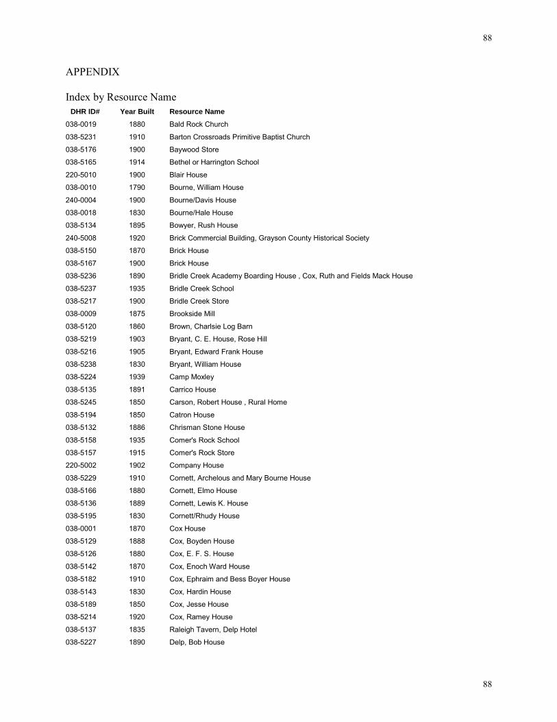
88
88
APPENDIX Index by Resource Name
DHR ID# Year Built Resource Name
038-0019 1880 Bald Rock Church
038-5231 1910 Barton Crossroads Primitive Baptist Church
038-5176 1900 Baywood Store
038-5165 1914 Bethel or Harrington School
220-5010 1900 Blair House
038-0010 1790 Bourne, William House
240-0004 1900 Bourne/Davis House
038-0018 1830 Bourne/Hale House
038-5134 1895 Bowyer, Rush House
240-5008 1920 Brick Commercial Building, Grayson County Historical Society
038-5150 1870 Brick House
038-5167 1900 Brick House
038-5236 1890 Bridle Creek Academy Boarding House , Cox, Ruth and Fields Mack House
038-5237 1935 Bridle Creek School
038-5217 1900 Bridle Creek Store
038-0009 1875 Brookside Mill
038-5120 1860 Brown, Charlsie Log Barn
038-5219 1903 Bryant, C. E. House, Rose Hill
038-5216 1905 Bryant, Edward Frank House
038-5238 1830 Bryant, William House
038-5224 1939 Camp Moxley
038-5135 1891 Carrico House
038-5245 1850 Carson, Robert House , Rural Home
038-5194 1850 Catron House
038-5132 1886 Chrisman Stone House
038-5158 1935 Comer's Rock School
038-5157 1915 Comer's Rock Store
220-5002 1902 Company House
038-5229 1910 Cornett, Archelous and Mary Bourne House
038-5166 1880 Cornett, Elmo House
038-5136 1889 Cornett, Lewis K. House
038-5195 1830 Cornett/Rhudy House
038-0001 1870 Cox House
038-5129 1888 Cox, Boyden House
038-5126 1880 Cox, E. F. S. House
038-5142 1870 Cox, Enoch Ward House
038-5182 1910 Cox, Ephraim and Bess Boyer House
038-5143 1830 Cox, Hardin House
038-5189 1850 Cox, Jesse House
038-5214 1920 Cox, Ramey House
038-5137 1835 Raleigh Tavern, Delp Hotel
038-5227 1890 Delp, Bob House
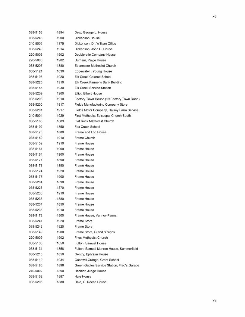
89
89
038-5156 1894 Delp, George L. House
038-5248 1900 Dickenson House
240-5006 1875 Dickenson, Dr. William Office
038-5249 1914 Dickenson, John C. House
220-5005 1902 Double-pile Company House
220-5006 1902 Durham, Paige House
038-5207 1880 Ebeneezer Methodist Church
038-5121 1830 Edgewater , Young House
038-5196 1920 Elk Creek Colored School
038-5225 1910 Elk Creek Farmer's Bank Building
038-5155 1930 Elk Creek Service Station
038-5209 1900 Elliot, Elbert House
038-5203 1910 Factory Town House (19 Factory Town Road)
038-5200 1917 Fields Manufacturing Company Store
038-5201 1917 Fields Motor Company, Halsey Farm Service
240-5004 1929 First Methodist Episcopal Church South
038-5168 1889 Flat Rock Methodist Church
038-5192 1850 Fox Creek School
038-5170 1880 Frame and Log House
038-5159 1910 Frame Church
038-5152 1910 Frame House
038-5161 1900 Frame House
038-5164 1900 Frame House
038-5171 1890 Frame House
038-5173 1890 Frame House
038-5174 1920 Frame House
038-5177 1900 Frame House
038-5204 1890 Frame House
038-5226 1870 Frame House
038-5230 1910 Frame House
038-5233 1880 Frame House
038-5234 1850 Frame House
038-5235 1910 Frame House
038-5172 1900 Frame House, Vannoy Farms
038-5241 1920 Frame Store
038-5242 1920 Frame Store
038-5149 1900 Frame Store, G and S Signs
220-5009 1902 Fries Methodist Church
038-5138 1850 Fulton, Samuel House
038-5131 1858 Fulton, Samuel Monroe House, Summerfield
038-5210 1850 Gentry, Ephraim House
038-5119 1934 Goodwill Grange, Grant School
038-5186 1896 Green Gables Service Station, Fred's Garage
240-5002 1890 Hackler, Judge House
038-5162 1887 Hale House
038-5206 1880 Hale, C. Reece House
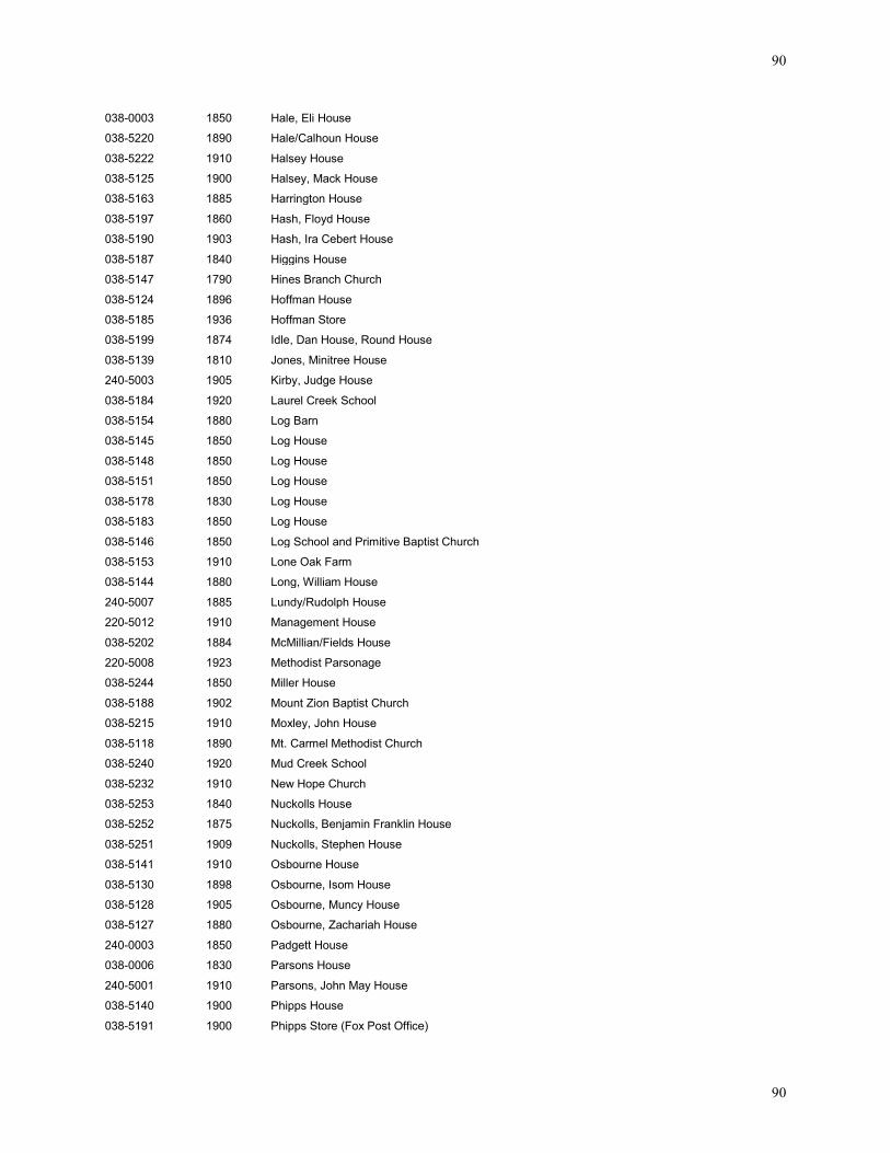
90
90
038-0003 1850 Hale, Eli House
038-5220 1890 Hale/Calhoun House
038-5222 1910 Halsey House
038-5125 1900 Halsey, Mack House
038-5163 1885 Harrington House
038-5197 1860 Hash, Floyd House
038-5190 1903 Hash, Ira Cebert House
038-5187 1840 Higgins House
038-5147 1790 Hines Branch Church
038-5124 1896 Hoffman House
038-5185 1936 Hoffman Store
038-5199 1874 Idle, Dan House, Round House
038-5139 1810 Jones, Minitree House
240-5003 1905 Kirby, Judge House
038-5184 1920 Laurel Creek School
038-5154 1880 Log Barn
038-5145 1850 Log House
038-5148 1850 Log House
038-5151 1850 Log House
038-5178 1830 Log House
038-5183 1850 Log House
038-5146 1850 Log School and Primitive Baptist Church
038-5153 1910 Lone Oak Farm
038-5144 1880 Long, William House
240-5007 1885 Lundy/Rudolph House
220-5012 1910 Management House
038-5202 1884 McMillian/Fields House
220-5008 1923 Methodist Parsonage
038-5244 1850 Miller House
038-5188 1902 Mount Zion Baptist Church
038-5215 1910 Moxley, John House
038-5118 1890 Mt. Carmel Methodist Church
038-5240 1920 Mud Creek School
038-5232 1910 New Hope Church
038-5253 1840 Nuckolls House
038-5252 1875 Nuckolls, Benjamin Franklin House
038-5251 1909 Nuckolls, Stephen House
038-5141 1910 Osbourne House
038-5130 1898 Osbourne, Isom House
038-5128 1905 Osbourne, Muncy House
038-5127 1880 Osbourne, Zachariah House
240-0003 1850 Padgett House
038-0006 1830 Parsons House
240-5001 1910 Parsons, John May House
038-5140 1900 Phipps House
038-5191 1900 Phipps Store (Fox Post Office)
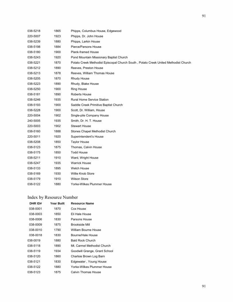
91
91
038-5218 1865 Phipps, Columbus House, Edgewood
220-5007 1923 Phipps, Dr. John House
038-5239 1880 Phipps, Larkin House
038-5198 1884 Pierce/Parsons House
038-5180 1900 Plank-framed House
038-5243 1920 Pond Mountain Missionary Baptist Church
038-5221 1870 Potato Creek Methodist Episcopal Church South , Potato Creek United Methodist Church
038-5212 1890 Reeves, Preston House
038-5213 1878 Reeves, William Thomas House
038-5205 1870 Rhudy House
038-5223 1890 Rhudy, Blake House
038-5250 1900 Ring House
038-5181 1890 Roberts House
038-5246 1935 Rural Home Service Station
038-5193 1900 Saddle Creek Primitive Baptist Church
038-5228 1900 Scott, Dr. William, House
220-5004 1902 Single-pile Company House
240-5005 1935 Smith, Dr. H. T. House
220-5003 1902 Stewart House
038-5160 1888 Stones Chapel Methodist Church
220-5011 1920 Superintendent’s House
038-5208 1850 Taylor House
038-5123 1875 Thomas, Calvin House
038-5175 1850 Todd House
038-5211 1910 Ward, Wright House
038-5247 1935 Warrick House
038-5133 1895 Welch House
038-5169 1930 Willie Knob Store
038-5179 1910 Wilson Store
038-5122 1880 Yorke-Wilkes Plummer House Index by Resource Number
DHR ID# Year Built Resource Name
038-0001 1870 Cox House
038-0003 1850 Eli Hale House
038-0006 1830 Parsons House
038-0009 1875 Brookside Mill
038-0010 1790 William Bourne House
038-0018 1830 Bourne/Hale House
038-0019 1880 Bald Rock Church
038-5118 1890 Mt. Carmel Methodist Church
038-5119 1934 Goodwill Grange, Grant School
038-5120 1860 Charlsie Brown Log Barn
038-5121 1830 Edgewater , Young House
038-5122 1880 Yorke-Wilkes Plummer House
038-5123 1875 Calvin Thomas House
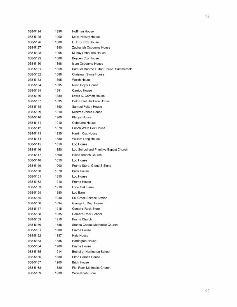
92
92
038-5124 1896 Hoffman House
038-5125 1900 Mack Halsey House
038-5126 1880 E. F. S. Cox House
038-5127 1880 Zachariah Osbourne House
038-5128 1905 Muncy Osbourne House
038-5129 1888 Boyden Cox House
038-5130 1898 Isom Osbourne House
038-5131 1858 Samuel Monroe Fulton House, Summerfield
038-5132 1886 Chrisman Stone House
038-5133 1895 Welch House
038-5134 1895 Rush Boyer House
038-5135 1891 Carrico House
038-5136 1889 Lewis K. Cornett House
038-5137 1835 Delp Hotel, Jackson House
038-5138 1850 Samuel Fulton House
038-5139 1810 Minitree Jones House
038-5140 1900 Phipps House
038-5141 1910 Osbourne House
038-5142 1870 Enoch Ward Cox House
038-5143 1830 Hardin Cox House
038-5144 1880 William Long House
038-5145 1850 Log House
038-5146 1850 Log School and Primitive Baptist Church
038-5147 1890 Hines Branch Church
038-5148 1850 Log House
038-5149 1900 Frame Store, G and S Signs
038-5150 1870 Brick House
038-5151 1850 Log House
038-5152 1910 Frame House
038-5153 1910 Lone Oak Farm
038-5154 1880 Log Barn
038-5155 1930 Elk Creek Service Station
038-5156 1894 George L. Delp House
038-5157 1915 Comer's Rock Storel
038-5158 1935 Comer's Rock School
038-5159 1910 Frame Church
038-5160 1888 Stones Chapel Methodist Church
038-5161 1900 Frame House
038-5162 1887 Hale House
038-5163 1885 Harrington House
038-5164 1900 Frame House
038-5165 1914 Bethel or Harrington School
038-5166 1880 Elmo Cornett House
038-5167 1900 Brick House
038-5168 1889 Flat Rock Methodist Church
038-5169 1930 Willie Knob Store
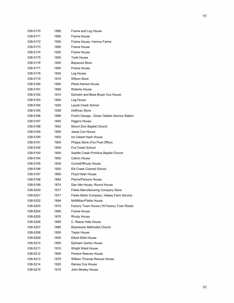
93
93
038-5170 1880 Frame and Log House
038-5171 1890 Frame House
038-5172 1900 Frame House, Vannoy Farms
038-5173 1890 Frame House
038-5174 1920 Frame House
038-5175 1850 Todd House
038-5176 1900 Baywood Store
038-5177 1900 Frame House
038-5178 1830 Log House
038-5179 1910 Wilson Store
038-5180 1900 Plank-framed House
038-5181 1890 Roberts House
038-5182 1910 Ephraim and Bess Boyer Cox House
038-5183 1850 Log House
038-5184 1920 Laurel Creek School
038-5185 1936 Hoffman Store
038-5186 1896 Fred's Garage , Green Gables Service Station
038-5187 1840 Higgins House
038-5188 1902 Mount Zion Baptist Church
038-5189 1850 Jesse Cox House
038-5190 1903 Ira Cebert Hash House
038-5191 1900 Phipps Store (Fox Post Office)
038-5192 1850 Fox Creek School
038-5193 1900 Saddle Creek Primitive Baptist Church
038-5194 1850 Catron House
038-5195 1830 Cornett/Rhudy House
038-5196 1920 Elk Creek Colored School
038-5197 1860 Floyd Hash House
038-5198 1884 Pierce/Parsons House
038-5199 1874 Dan Idle House, Round House
038-5200 1917 Fields Manufacturing Company Store
038-5201 1917 Fields Motor Company, Halsey Farm Service
038-5202 1884 McMillian/Fields House
038-5203 1910 Factory Town House (19 Factory Town Road)
038-5204 1890 Frame House
038-5205 1870 Rhudy House
038-5206 1880 C. Reece Hale House
038-5207 1880 Ebeneezer Methodist Church
038-5208 1850 Taylor House
038-5209 1900 Elbert Elliot House
038-5210 1850 Ephraim Gentry House
038-5211 1910 Wright Ward House
038-5212 1890 Preston Reeves House
038-5213 1878 William Thomas Reeves House
038-5214 1920 Ramey Cox House
038-5215 1910 John Moxley House
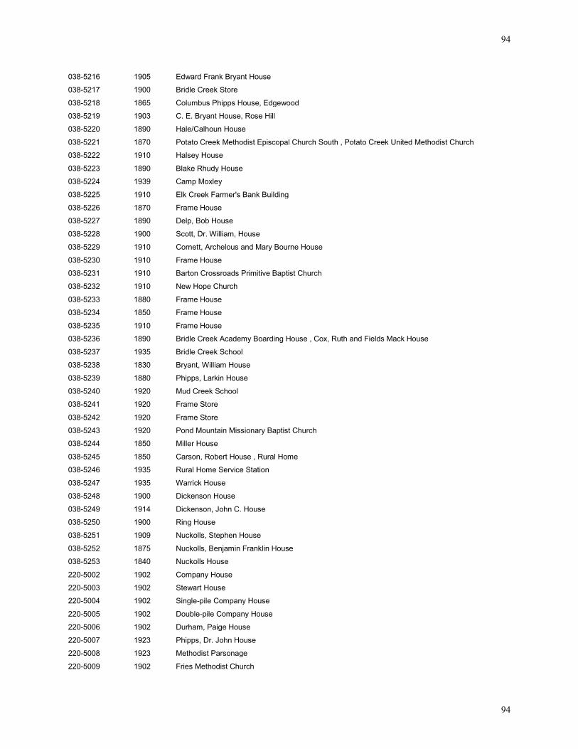
94
94
038-5216 1905 Edward Frank Bryant House
038-5217 1900 Bridle Creek Store
038-5218 1865 Columbus Phipps House, Edgewood
038-5219 1903 C. E. Bryant House, Rose Hill
038-5220 1890 Hale/Calhoun House
038-5221 1870 Potato Creek Methodist Episcopal Church South , Potato Creek United Methodist Church
038-5222 1910 Halsey House
038-5223 1890 Blake Rhudy House
038-5224 1939 Camp Moxley
038-5225 1910 Elk Creek Farmer's Bank Building
038-5226 1870 Frame House
038-5227 1890 Delp, Bob House
038-5228 1900 Scott, Dr. William, House
038-5229 1910 Cornett, Archelous and Mary Bourne House
038-5230 1910 Frame House
038-5231 1910 Barton Crossroads Primitive Baptist Church
038-5232 1910 New Hope Church
038-5233 1880 Frame House
038-5234 1850 Frame House
038-5235 1910 Frame House
038-5236 1890 Bridle Creek Academy Boarding House , Cox, Ruth and Fields Mack House
038-5237 1935 Bridle Creek School
038-5238 1830 Bryant, William House
038-5239 1880 Phipps, Larkin House
038-5240 1920 Mud Creek School
038-5241 1920 Frame Store
038-5242 1920 Frame Store
038-5243 1920 Pond Mountain Missionary Baptist Church
038-5244 1850 Miller House
038-5245 1850 Carson, Robert House , Rural Home
038-5246 1935 Rural Home Service Station
038-5247 1935 Warrick House
038-5248 1900 Dickenson House
038-5249 1914 Dickenson, John C. House
038-5250 1900 Ring House
038-5251 1909 Nuckolls, Stephen House
038-5252 1875 Nuckolls, Benjamin Franklin House
038-5253 1840 Nuckolls House
220-5002 1902 Company House
220-5003 1902 Stewart House
220-5004 1902 Single-pile Company House
220-5005 1902 Double-pile Company House
220-5006 1902 Durham, Paige House
220-5007 1923 Phipps, Dr. John House
220-5008 1923 Methodist Parsonage
220-5009 1902 Fries Methodist Church
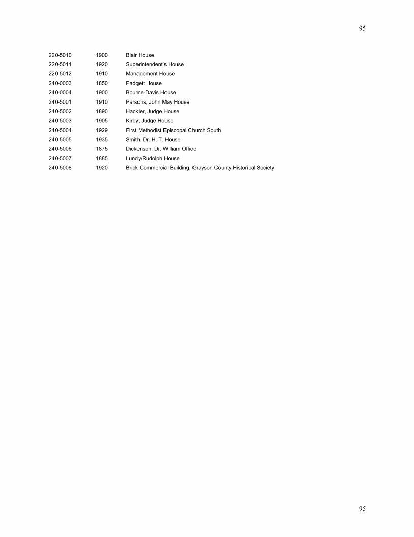
95
95
220-5010 1900 Blair House
220-5011 1920 Superintendent’s House
220-5012 1910 Management House
240-0003 1850 Padgett House
240-0004 1900 Bourne-Davis House
240-5001 1910 Parsons, John May House
240-5002 1890 Hackler, Judge House
240-5003 1905 Kirby, Judge House
240-5004 1929 First Methodist Episcopal Church South
240-5005 1935 Smith, Dr. H. T. House
240-5006 1875 Dickenson, Dr. William Office
240-5007 1885 Lundy/Rudolph House
240-5008 1920 Brick Commercial Building, Grayson County Historical Society