Embed Size (px)
Citation preview

Erin McGrew
1
A Survey and Discussion of the Invasive Anolis cristatellus and the
Endemic Anolis oculatus
Erin McGrew Study Abroad Dominica
May-June 2015 Dr. Lacher and Dr. Woolley
Erin McGrew
2
Abstract
Anolis cristatellus is a nonnative species of anole inhabiting the island of Dominica. Its presence is worth observing because it poses a potential threat to the endemic Anolis oculatus. The purpose of this study is to survey the most recent range expansions of the invasive Anolis cristatellus and investigate if it is outcompeting the native Anolis oculatus. Data were collected using a survey method at various locations around the island. The invasion has expanded from its original contained area in Roseau, although it is maintained in human disturbed areas and has not extended into the heavily forested regions.
Introduction The Island of Dominica is often noted as possessing the most complete extant amphibian and reptile diversity out of all the Lesser Antilles (Malhotra et al., 2007). 21 species of reptiles and four species of amphibians inhabit the island of Dominica, five of which are endemic to the Lesser Antilles. (Alexander, 2007)
The Dominican Anole, Anolis oculatus, is an endemic lizard that is currently facing threats of extirpation from the invasive species, Puerto Rican Crested Anole Anolis cristatellus (Malhotra et al., 2011). A previous Texas A&M Dominica study completed five years ago showed the invasion to be contained to the Roseau/ Canefield area, for A. cristatellus was only observed at the Botanical Gardens in Roseau (Reinhart, 2010). Although the invasive Crested Anoles are present, the IUCN Red List currently classifies Anolis oculatus as a species of least concern (Hedges et al., 2013). The purpose of this study is to survey the most recent range expansions of the invasive Anolis cristatellus and investigate if it is outcompeting the native Anolis oculatus.
Experimental Design Data were collected using a survey method at various locations around the island. For each species found, the number of anoles and general habitat characteristics will be documented in a field notebook. Location coordinates and elevation will be determined using a Garmin 78 GPS unit. Google Earth will be used to map a general distribution of Anolis oculatus and Anolis cristatellus.
Locations for surveys will include trails originating at the Springfield Archbold Research and Education Centre, Roseau botanical gardens, and other national parks and tourist sites including Middleham Falls, Emerald Pool, Castle Bruce Beach, Cabrits National Park, Syndicate National Park, and Boeri Lake.
Finally, results will be compared to a previous Dominica study done in 2010. From the comparisons I hope to see if the invasive Anolis cristatellus is expanding its range on the island, for the 2010 study showed that A. cristatellus was contained in the Roseau/ Canefield area. I will determine if the invasive anole is out competing Anolis oculatus if only A. cristatellus is found in places where A. oculatus once was.
Results
Erin McGrew
3
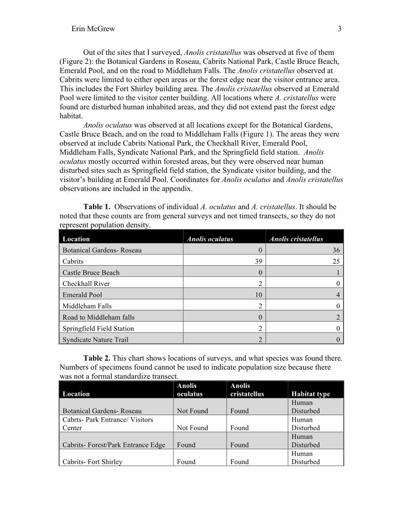
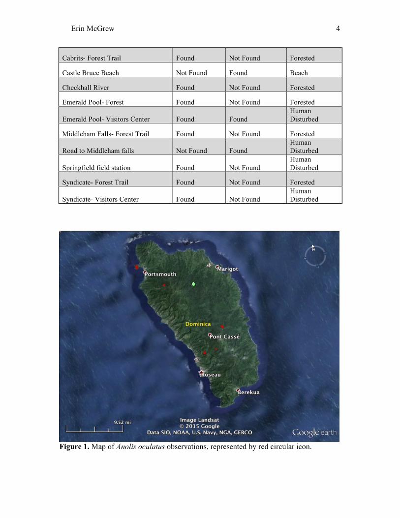
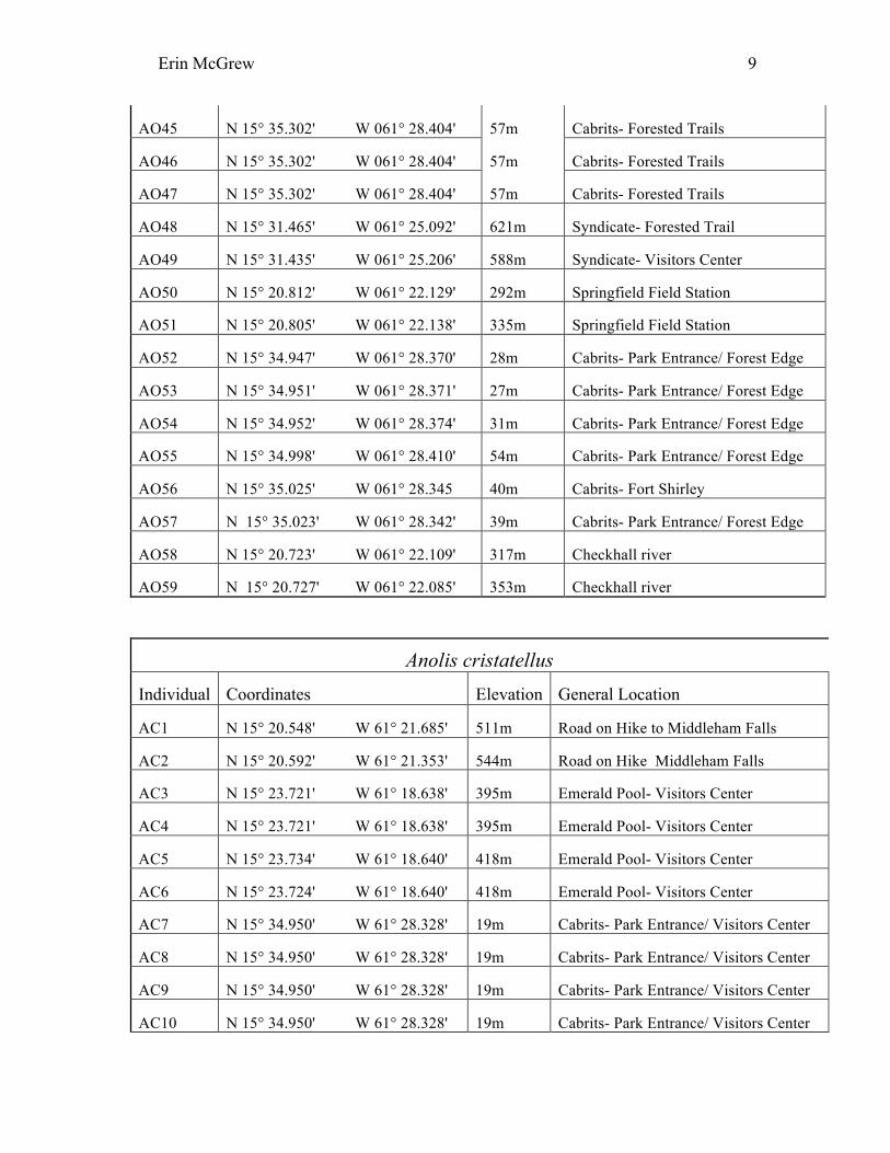
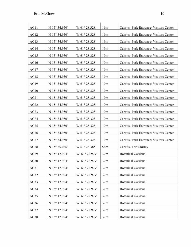
Out of the sites that I surveyed, Anolis cristatellus was observed at five of them (Figure 2): the Botanical Gardens in Roseau, Cabrits National Park, Castle Bruce Beach, Emerald Pool, and on the road to Middleham Falls. The Anolis cristatellus observed at Cabrits were limited to either open areas or the forest edge near the visitor entrance area. This includes the Fort Shirley building area. The Anolis cristatellus observed at Emerald Pool were limited to the visitor center building. All locations where A. cristatellus were found are disturbed human inhabited areas, and they did not extend past the forest edge habitat.
Anolis oculatus was observed at all locations except for the Botanical Gardens, Castle Bruce Beach, and on the road to Middleham Falls (Figure 1). The areas they were observed at include Cabrits National Park, the Checkhall River, Emerald Pool, Middleham Falls, Syndicate National Park, and the Springfield field station. Anolis oculatus mostly occurred within forested areas, but they were observed near human disturbed sites such as Springfield field station, the Syndicate visitor building, and the visitor’s building at Emerald Pool. Coordinates for Anolis oculatus and Anolis cristatellus observations are included in the appendix.
Table 1. Observations of individual A. oculatus and A. cristatellus. It should be
noted that these counts are from general surveys and not timed transects, so they do not represent population density.
Location Anolis oculatus Anolis cristatellus Botanical Gardens- Roseau 0 36 Cabrits 39 25 Castle Bruce Beach 0 1 Checkhall River 2 0 Emerald Pool 10 4 Middleham Falls 2 0 Road to Middleham falls 0 2 Springfield Field Station 2 0 Syndicate Nature Trail 2 0
Table 2. This chart shows locations of surveys, and what species was found there.
Numbers of specimens found cannot be used to indicate population size because there was not a formal standardize transect.
Location Anolis oculatus
Anolis cristatellus Habitat type
Botanical Gardens- Roseau Not Found Found Human Disturbed
Cabrts- Park Entrance/ Visitors Center Not Found Found
Human Disturbed
Cabrits- Forest/Park Entrance Edge Found Found Human Disturbed
Cabrits- Fort Shirley Found Found Human Disturbed
Erin McGrew
4
Cabrits- Forest Trail Found Not Found Forested
Castle Bruce Beach Not Found Found Beach
Checkhall River Found Not Found Forested
Emerald Pool- Forest Found Not Found Forested
Emerald Pool- Visitors Center Found Found Human Disturbed
Middleham Falls- Forest Trail Found Not Found Forested
Road to Middleham falls Not Found Found Human Disturbed
Springfield field station Found Not Found Human Disturbed
Syndicate- Forest Trail Found Not Found Forested
Syndicate- Visitors Center Found Not Found Human Disturbed
Figure 1. Map of Anolis oculatus observations, represented by red circular icon.

Erin McGrew
5
Figure 2. Map of Anolis cristatellus observations, represented by yellow circular icon.
Erin McGrew
6
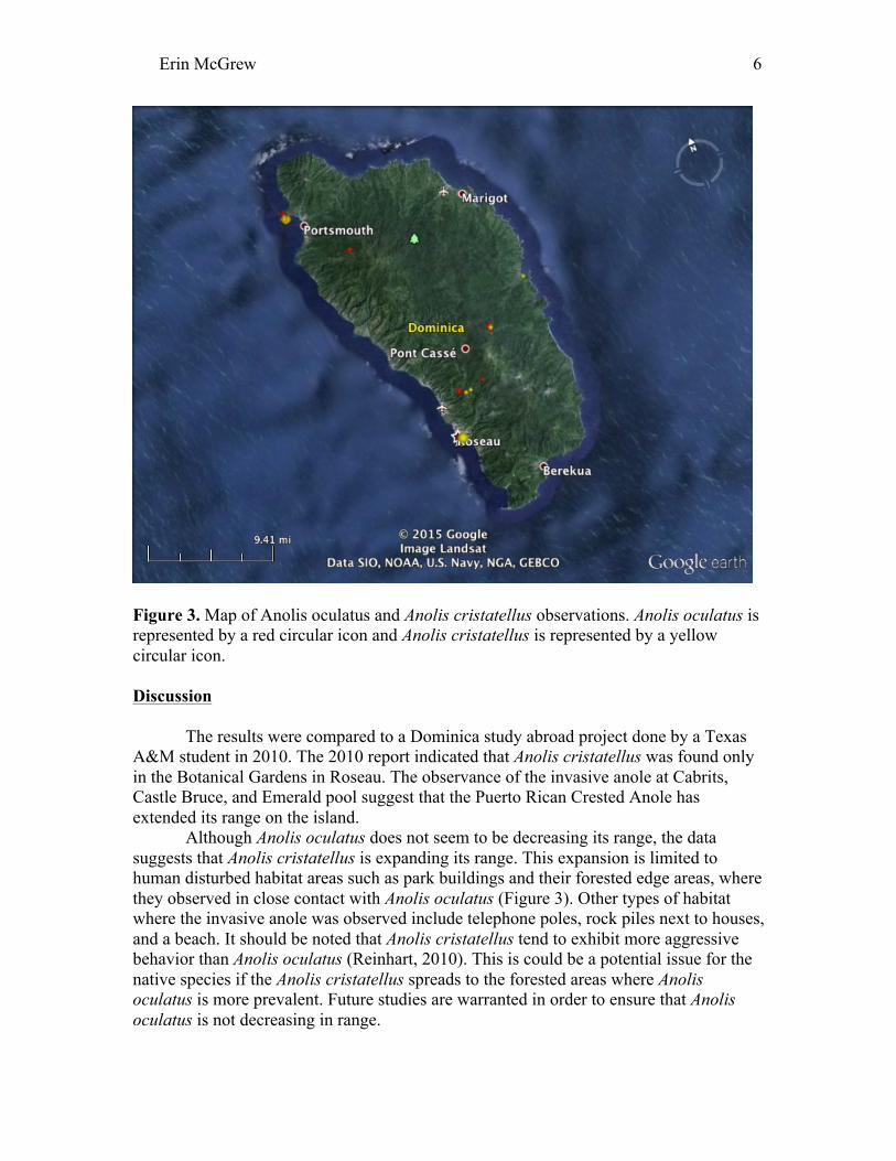
Figure 3. Map of Anolis oculatus and Anolis cristatellus observations. Anolis oculatus is represented by a red circular icon and Anolis cristatellus is represented by a yellow circular icon. Discussion
The results were compared to a Dominica study abroad project done by a Texas A&M student in 2010. The 2010 report indicated that Anolis cristatellus was found only in the Botanical Gardens in Roseau. The observance of the invasive anole at Cabrits, Castle Bruce, and Emerald pool suggest that the Puerto Rican Crested Anole has extended its range on the island.
Although Anolis oculatus does not seem to be decreasing its range, the data suggests that Anolis cristatellus is expanding its range. This expansion is limited to human disturbed habitat areas such as park buildings and their forested edge areas, where they observed in close contact with Anolis oculatus (Figure 3). Other types of habitat where the invasive anole was observed include telephone poles, rock piles next to houses, and a beach. It should be noted that Anolis cristatellus tend to exhibit more aggressive behavior than Anolis oculatus (Reinhart, 2010). This is could be a potential issue for the native species if the Anolis cristatellus spreads to the forested areas where Anolis oculatus is more prevalent. Future studies are warranted in order to ensure that Anolis oculatus is not decreasing in range.
Erin McGrew
7
Conclusion
Anolis cristatellus was not observed within heavily forested areas, although the species was observed within the boundaries between forested and human impacted areas. Anolis oculatus does not appear to be drastically affected by the presence of the nonnative species. This issue should continue to be monitored because of the evident range expansion that has occurred within the last five years.
Acknowledgments I would like to thank the herp team, especially Sydney, Nick, and Brittany, for helping me in the rewarding, yet frustrating, capture of anoles. I would also like to thank Dr. Lacher and Dr. Woolley for this incredible experience and for going out of their way to help all of us students succeed in our research. Appendix
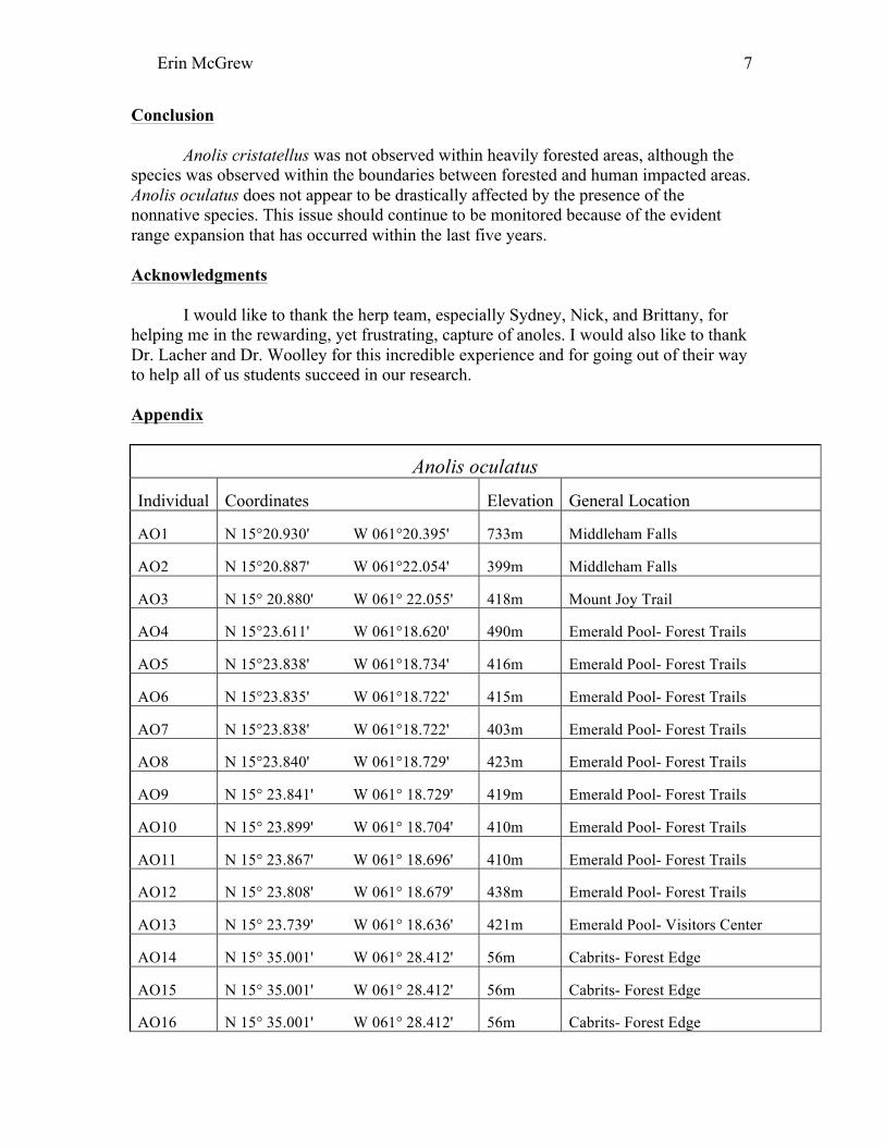
Anolis oculatus
Individual Coordinates Elevation General Location
AO1 N 15°20.930' W 061°20.395' 733m Middleham Falls
AO2 N 15°20.887' W 061°22.054' 399m Middleham Falls
AO3 N 15° 20.880' W 061° 22.055' 418m Mount Joy Trail
AO4 N 15°23.611' W 061°18.620' 490m Emerald Pool- Forest Trails
AO5 N 15°23.838' W 061°18.734' 416m Emerald Pool- Forest Trails
AO6 N 15°23.835' W 061°18.722' 415m Emerald Pool- Forest Trails
AO7 N 15°23.838' W 061°18.722' 403m Emerald Pool- Forest Trails
AO8 N 15°23.840' W 061°18.729' 423m Emerald Pool- Forest Trails
AO9 N 15° 23.841' W 061° 18.729' 419m Emerald Pool- Forest Trails
AO10 N 15° 23.899' W 061° 18.704' 410m Emerald Pool- Forest Trails
AO11 N 15° 23.867' W 061° 18.696' 410m Emerald Pool- Forest Trails
AO12 N 15° 23.808' W 061° 18.679' 438m Emerald Pool- Forest Trails
AO13 N 15° 23.739' W 061° 18.636' 421m Emerald Pool- Visitors Center
AO14 N 15° 35.001' W 061° 28.412' 56m Cabrits- Forest Edge
AO15 N 15° 35.001' W 061° 28.412' 56m Cabrits- Forest Edge
AO16 N 15° 35.001' W 061° 28.412' 56m Cabrits- Forest Edge
Erin McGrew
8
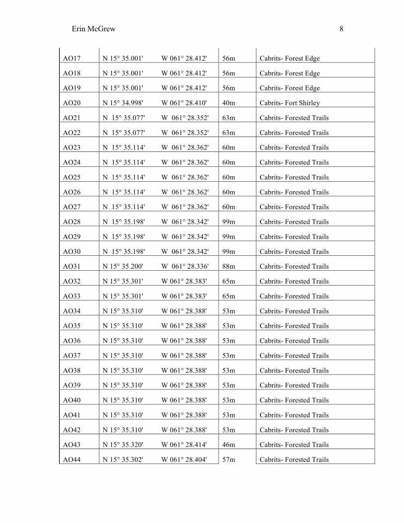
AO17 N 15° 35.001' W 061° 28.412' 56m Cabrits- Forest Edge
AO18 N 15° 35.001' W 061° 28.412' 56m Cabrits- Forest Edge
AO19 N 15° 35.001' W 061° 28.412' 56m Cabrits- Forest Edge
AO20 N 15° 34.998' W 061° 28.410' 40m Cabrits- Fort Shirley
AO21 N 15° 35.077' W 061° 28.352' 63m Cabrits- Forested Trails
AO22 N 15° 35.077' W 061° 28.352' 63m Cabrits- Forested Trails
AO23 N 15° 35.114' W 061° 28.362' 60m Cabrits- Forested Trails
AO24 N 15° 35.114' W 061° 28.362' 60m Cabrits- Forested Trails
AO25 N 15° 35.114' W 061° 28.362' 60m Cabrits- Forested Trails
AO26 N 15° 35.114' W 061° 28.362' 60m Cabrits- Forested Trails
AO27 N 15° 35.114' W 061° 28.362' 60m Cabrits- Forested Trails
AO28 N 15° 35.198' W 061° 28.342' 99m Cabrits- Forested Trails
AO29 N 15° 35.198' W 061° 28.342' 99m Cabrits- Forested Trails
AO30 N 15° 35.198' W 061° 28.342' 99m Cabrits- Forested Trails
AO31 N 15° 35.200' W 061° 28.336' 88m Cabrits- Forested Trails
AO32 N 15° 35.301' W 061° 28.383' 65m Cabrits- Forested Trails
AO33 N 15° 35.301' W 061° 28.383' 65m Cabrits- Forested Trails
AO34 N 15° 35.310' W 061° 28.388' 53m Cabrits- Forested Trails
AO35 N 15° 35.310' W 061° 28.388' 53m Cabrits- Forested Trails
AO36 N 15° 35.310' W 061° 28.388' 53m Cabrits- Forested Trails
AO37 N 15° 35.310' W 061° 28.388' 53m Cabrits- Forested Trails
AO38 N 15° 35.310' W 061° 28.388' 53m Cabrits- Forested Trails
AO39 N 15° 35.310' W 061° 28.388' 53m Cabrits- Forested Trails
AO40 N 15° 35.310' W 061° 28.388' 53m Cabrits- Forested Trails
AO41 N 15° 35.310' W 061° 28.388' 53m Cabrits- Forested Trails
AO42 N 15° 35.310' W 061° 28.388' 53m Cabrits- Forested Trails
AO43 N 15° 35.320' W 061° 28.414' 46m Cabrits- Forested Trails
AO44 N 15° 35.302' W 061° 28.404' 57m Cabrits- Forested Trails
Erin McGrew
9
AO45 N 15° 35.302' W 061° 28.404' 57m Cabrits- Forested Trails
AO46 N 15° 35.302' W 061° 28.404' 57m Cabrits- Forested Trails
AO47 N 15° 35.302' W 061° 28.404' 57m Cabrits- Forested Trails
AO48 N 15° 31.465' W 061° 25.092' 621m Syndicate- Forested Trail
AO49 N 15° 31.435' W 061° 25.206' 588m Syndicate- Visitors Center
AO50 N 15° 20.812' W 061° 22.129' 292m Springfield Field Station
AO51 N 15° 20.805' W 061° 22.138' 335m Springfield Field Station
AO52 N 15° 34.947' W 061° 28.370' 28m Cabrits- Park Entrance/ Forest Edge
AO53 N 15° 34.951' W 061° 28.371' 27m Cabrits- Park Entrance/ Forest Edge
AO54 N 15° 34.952' W 061° 28.374' 31m Cabrits- Park Entrance/ Forest Edge
AO55 N 15° 34.998' W 061° 28.410' 54m Cabrits- Park Entrance/ Forest Edge
AO56 N 15° 35.025' W 061° 28.345 40m Cabrits- Fort Shirley
AO57 N 15° 35.023' W 061° 28.342' 39m Cabrits- Park Entrance/ Forest Edge
AO58 N 15° 20.723' W 061° 22.109' 317m Checkhall river
AO59 N 15° 20.727' W 061° 22.085' 353m Checkhall river
Anolis cristatellus Individual Coordinates Elevation General Location
AC1 N 15° 20.548' W 61° 21.685' 511m Road on Hike to Middleham Falls
AC2 N 15° 20.592' W 61° 21.353' 544m Road on Hike Middleham Falls
AC3 N 15° 23.721' W 61° 18.638' 395m Emerald Pool- Visitors Center
AC4 N 15° 23.721' W 61° 18.638' 395m Emerald Pool- Visitors Center
AC5 N 15° 23.734' W 61° 18.640' 418m Emerald Pool- Visitors Center
AC6 N 15° 23.724' W 61° 18.640' 418m Emerald Pool- Visitors Center
AC7 N 15° 34.950' W 61° 28.328' 19m Cabrits- Park Entrance/ Visitors Center
AC8 N 15° 34.950' W 61° 28.328' 19m Cabrits- Park Entrance/ Visitors Center
AC9 N 15° 34.950' W 61° 28.328' 19m Cabrits- Park Entrance/ Visitors Center
AC10 N 15° 34.950' W 61° 28.328' 19m Cabrits- Park Entrance/ Visitors Center
Erin McGrew
10
AC11 N 15° 34.950' W 61° 28.328' 19m Cabrits- Park Entrance/ Visitors Center
AC12 N 15° 34.950' W 61° 28.328' 19m Cabrits- Park Entrance/ Visitors Center
AC13 N 15° 34.950' W 61° 28.328' 19m Cabrits- Park Entrance/ Visitors Center
AC14 N 15° 34.950' W 61° 28.328' 19m Cabrits- Park Entrance/ Visitors Center
AC15 N 15° 34.950' W 61° 28.328' 19m Cabrits- Park Entrance/ Visitors Center
AC16 N 15° 34.950' W 61° 28.328' 19m Cabrits- Park Entrance/ Visitors Center
AC17 N 15° 34.950' W 61° 28.328' 19m Cabrits- Park Entrance/ Visitors Center
AC18 N 15° 34.950' W 61° 28.328' 19m Cabrits- Park Entrance/ Visitors Center
AC19 N 15° 34.950' W 61° 28.328' 19m Cabrits- Park Entrance/ Visitors Center
AC20 N 15° 34.950' W 61° 28.328' 19m Cabrits- Park Entrance/ Visitors Center
AC21 N 15° 34.950' W 61° 28.328' 19m Cabrits- Park Entrance/ Visitors Center
AC22 N 15° 34.950' W 61° 28.328' 19m Cabrits- Park Entrance/ Visitors Center
AC23 N 15° 34.950' W 61° 28.328' 19m Cabrits- Park Entrance/ Visitors Center
AC24 N 15° 34.950' W 61° 28.328' 19m Cabrits- Park Entrance/ Visitors Center
AC25 N 15° 34.950' W 61° 28.328' 19m Cabrits- Park Entrance/ Visitors Center
AC26 N 15° 34.950' W 61° 28.328' 19m Cabrits- Park Entrance/ Visitors Center
AC27 N 15° 34.950' W 61° 28.328' 19m Cabrits- Park Entrance/ Visitors Center
AC28 N 15° 35.036' W 61° 28.385' 56m Cabrits- Fort Shirley
AC29 N 15° 17.924' W 61° 22.977' 37m Botanical Gardens
AC30 N 15° 17.924' W 61° 22.977' 37m Botanical Gardens
AC31 N 15° 17.924' W 61° 22.977' 37m Botanical Gardens
AC32 N 15° 17.924' W 61° 22.977' 37m Botanical Gardens
AC33 N 15° 17.924' W 61° 22.977' 37m Botanical Gardens
AC34 N 15° 17.924' W 61° 22.977' 37m Botanical Gardens
AC35 N 15° 17.924' W 61° 22.977' 37m Botanical Gardens
AC36 N 15° 17.924' W 61° 22.977' 37m Botanical Gardens
AC37 N 15° 17.924' W 61° 22.977' 37m Botanical Gardens
AC38 N 15° 17.924' W 61° 22.977' 37m Botanical Gardens

Erin McGrew
11
AC39 N 15° 17.924' W 61° 22.977' 37m Botanical Gardens
AC40 N 15° 17.924' W 61° 22.977' 37m Botanical Gardens
AC41 N 15° 17.924' W 61° 22.977' 37m Botanical Gardens
AC42 N 15° 17.924' W 61° 22.977' 37m Botanical Gardens
AC43 N 15° 17.924' W 61° 22.977' 37m Botanical Gardens
AC44 N 15° 17.924' W 61° 22.977' 37m Botanical Gardens
AC45 N 15° 17.924' W 61° 22.977' 37m Botanical Gardens
AC46 N 15° 17.924' W 61° 22.977' 37m Botanical Gardens
AC47 N 15° 17.924' W 61° 22.977' 37m Botanical Gardens
AC48 N 15° 17.924' W 61° 22.977' 37m Botanical Gardens
AC49 N 15° 17.924' W 61° 22.977' 37m Botanical Gardens
AC50 N 15° 17.924' W 61° 22.977' 37m Botanical Gardens
AC51 N 15° 17.924' W 61° 22.977' 37m Botanical Gardens
AC52 N 15° 17.924' W 61° 22.977' 37m Botanical Gardens
AC53 N 15° 17.924' W 61° 22.977' 37m Botanical Gardens
AC54 N 15° 17.924' W 61° 22.977' 37m Botanical Gardens
AC55 N 15° 25.934' W 61° 15.319' 5m Castle Bruce Beach
AC56 N 15° 34.949' W 61° 28.369' 20m Cabrits- Forest/ Park Entrance Edge
Erin McGrew
12
AC57 N 15° 34.980' W 61° 28.416' 62m Cabrits- Fort Shirley
AC58 N 15° 35.023' W 61° 28.342 353m Cabrits- Forest/ Park Entrance Edge
References Cited Hedges, S.B., Mayer, G.C. & Powell, R. 2013. Anolis oculatus. The IUCN Red List of
Threatened Species. Version 2014.3. <www.iucnredlist.org>. Downloaded on 29 March 2015.
Malhotra, A., Thorpe, R. S., Hypolite, E., & James, A. 2011. A report on the
status of the herpetofauna of the Commonwealth of Dominica, West Indies. Conservation of Caribbean Island Herpetofaunas, 2, 149-166.
Malhotra, A., Thorpe, R. S., Hypolite, E., & James, A. 2007. A report on
the status of the herpetofauna of the Commonwealth of Dominica, West Indies. Applied Herpetology, 4(2), 177-194.
Alexander, Kristen. A Photographic Field Guide to the Reptiles and Amphibians of Dominica, West Indies. Texas A&M University, Dominica Study Abroad 2007. Reinhart, Sammy. A Survey and Discussion of the Invasion of Anolis cristatellus and
its effects on the endemic Anolis oculatus. Texas A&M University, Dominica Study Abroad 2010.