Embed Size (px)
Citation preview

CHAPTER 5
A Study on Economic Corridors and Industrial Zones, Ports and Metropolitan and Alternative Roads in Myanmar
Myinmo Zaw and Toshihiro Kudo
This chapter should be cited as:
ZAW, Myinmo, and Toshihiro KUDO, 2011. “A Study on Economic Corridors and Industrial
Zones, Ports and Metropolitan and Alternative Roads in Myanmar.” In Intra- and Inter-City
Connectivity in the Mekong Region, edited by Masami Ishida, BRC Research Report No.6,
Bangkok Research Center, IDE-JETRO, Bangkok, Thailand.

CHAPTER 5
A STUDY ON ECONOMIC CORRIDORS AND
INDUSTRIAL ZONES, PORTS, AND METROPOLITAN
AND ALTERNATIVE ROADS IN MYANMAR
Myinmo Zaw and Toshihiro Kudo
INTRODUCTION
Myanmar, a country in Southeast Asia, borders India, Bangladesh, China, Laos, and
Thailand, serving as a crucial trading hub for the region. This country with a thriving
population of more than 55 million people is ripe for investment and exponential
economic growth within the next decade. Myanmar is a country rich in natural resources
such as precious gems, priceless jade, natural gas, petroleum, copper, nickel, tin, gold,
silver, zinc, and a host of other raw materials. Myanmar is also rich in terms of agriculture
and fishery resources and has a high volume of annual exports from these two industries.
In modern times, the Republic of the Union of Myanmar has become a crucial component
in the East-West Economic Corridor, ASEAN’s economic development, and the
provision of a regional commerce link between China, India, and Southeast Asia.
A survey was conducted in the major cities of Myanmar such as Yangon,
Mandalay, Mawlamyaine, and Dawei to collect various data on industrial zones, ports
and harbors, airports, roads, railways, and other development projects. Among the
241

selected cities, Yangon and Mandalay are metropolitan areas while Mawlamyaine was
the third-largest city and the projected end of the East-West Economic Corridor, and
Dawei is assumed to be a new extension of the Southern Economic Corridor. This
paper will discuss the current situation, the possibilities of a development plan, and the
advantages and disadvantages of industrial zones and transportation linkages.
Yangon, formerly the political capital up to 2005, continues to be the country’s
commercial and logistics hub for international trade. It has the highest concentration of
industrial production facilities in Myanmar. Yangon also has the largest metropolitan
population, and therefore the biggest number of public transport facilities in the
country. The ports and harbors in the Yangon area facilitate almost the entire
international overseas container and cargo trade. The majority of the country’s
production facilities are located within the Yangon region due to the establishment of
23 industrial zones. Although the industrial zones lack one-stop service and adequate
utilities, infrastructure and management, it is still considered an advantage for
companies to invest in the zones if they want to manufacture goods which will be
consumed by the general Myanmar population or want to take advantage of the cheap
labor for export-oriented production.
Mandalay, the ancient capital, is situated geographically in the middle of the
country. It is the second-largest city in Myanmar and is located in the Mandalay
Division, which has the largest population of all divisions. Although there are some
small and medium-size industrial enterprises located in the Mandalay Industrial Zone,
and in the surrounding area, the majority of the people in the Mandalay Division derive
their livelihood from agriculture and commerce (via inland waterways or overland
trucking routes). Mandalay is located in the designated dry zone region, due to the low
242

levels of annual rainfall as well as the fact that beans, pulses, and cotton are the main
crops which thrive in the area. The major highway connecting the China-Myanmar
border to Mandalay and onward to Yangon serves as the primary artery for trade and
commerce. Along this busy commercial route, raw materials such as rubber and ore
and agriculture products are exported while manufactured goods and finished products
are imported.
Mawlamyaine, a midway point between the southern coastal cities of Myanmar
and the main city of Yangon, used to be an important trading hub. The small docks and
jetties located along the city’s coastline were used to transport bulk goods along the
many rivers and waterways connecting Mawlamyaine to Yangon or into the heartland.
Railroads and commercial trucking roads from Myeik and Dawei pass through
Mawlamyaine and link up with Yangon as well. The importance of the city is due to
the Greater Mekong Subregion program’s designation of Mawlamyaine as the entry
and exit point of the western end of the East-West Economic Corridor. This crucial
trading and commerce corridor links Thailand, Myanmar, Vietnam, and Laos. The road
linking Myanmar and Thailand via the Friendship Bridge, between Myawaddy and
Mae Sot, has been used for commerce, which provided a major source of revenue for
traders and merchants in Mawlamyaine. Due to the development of new roadways and
trading networks that circumvent Mawlamyaine, the city has lost most of its revenue
and importance as a commercial hub within the past decade. Although there is a small
industrial zone located a few kilometers from the city, the industrial capacity is
insufficient and meager at best. Recent developments in roads, bridges, and
commercial routes have rendered this trading city obsolete and researchers must now
consider Yangon as the entry and exit point of the East-West Economic Corridor.
243

Dawei, an important trading port city during the colonial times, has become less
important in the modern era due to the advent of commercial shipping and commercial
highways. This city located in the Taninthary Division serves as a city center and small
commercial hub for goods from Thailand passing through from Ranong and other Thai
border towns. Currently the rubber processing, planting, harvesting, and palm oil
industries are the primary industries in the area but future economic prospects for
Dawei are highly positive. The Italian-Thai Development Public Company Limited’s
proposed deep-sea port and special economic zone project, initiated in 2008, is the key
factor to Dawei’s future prosperity. The project will fully utilize Dawei’s potential to
become a highly developed international container port and manufacturing facility,
enriching both the Thai and Myanmar economies as well as creating revenue for
international investors. There is much debate over the cost and feasibility of this
project but optimists view it as a way to extend the Southern Economic Corridor from
Bangkok to Dawei and create a base of operations where companies and governments
can invest, resulting in exponential commercial growth in the region.
Industrial zones were implemented by authorities in the 1990s to create a
designated area for manufacturing facilities and a base of operations for investors in
and around the major cities in Myanmar. Initially there were only a few locations
around the Yangon City area due to the developed transportation networks, roads, and
port infrastructure. Gradually, over the decades, more than 23 industrial zones have
been created in Yangon alone. There are 18 other industrial zones in the country in
cities such as Mandalay, Meikhtila, Monywa, Pakokku, Myaung Mya, Mawlamyaine,
Myeik, Bago, and Pyay. The crucial issues faced by investors that chose to locate
factories in these zones are the lack of one-stop service, special economic/tax treatment
244

and an effective zone management authority, and the problems with power shortages,
water supply, water treatment, road infrastructure, and export/import processes. With
development of special economic zone policies and a focus on development of zone
infrastructure and management, Myanmar could potentially become a highly attractive
market for international investment.
1. DIFFERENT FUNCTIONS AND CHARACTERISTICS OF
MAJOR CITIES
1.1. Yangon
Yangon was the capital of Myanmar until 2005 and it remains the country’s most
populated business city. The largest urban center known as the Greater Yangon
metropolitan area is situated in the Yangon Division that forms four districts and 45
townships. The city plays a vital role in the country’s economy due to its overseas trading
ports and existence as the largest manufacturing and trading center. The GDP of the
Yangon Division in 2009-2010 (at 2005-2006 constant price) was kyat 3,855 billion, or
20.4% of the country’s economy. A total of 33 townships out of the 45 townships in the
Yangon Division are under the Yangon City municipal area and administered by the
Yangon City Development Committee. There are 33 townships, 735 wards, and 3,666
roads and streets in Yangon City. The city has the largest port, handling about 90% of
Myanmar’s overseas trade (if we exclude the natural gas exports to Thailand by pipeline).
Most of the labor-intensive export-oriented industries such as garments and footwear are
located in the city area.
245

After opening up to the outside commercial world through more than 20 years of
the market economy policy, Yangon has experienced the rapid growth of private
businesses soaring in number by about 10 times since 1988. More service-oriented
businesses have emerged in Yangon, where previously there had been only trade-based
ones. Yangon businesses rely heavily on the local market, which is growing larger year
by year. Most businesses focus mainly on the Yangon market, which is the largest
consumer market of Myanmar with more than 5 million people and high affordability.
However, the production sector still has room to expand, even though many
industrial zones have already been developed and established. Most of the locally
produced products are still inconsistent in quality, and as such efforts should be made
to push toward quality production for integration in the international market. If
production, trading, and services are more balanced with better distribution networks
and less curtailing factors, there would be an upswing in future Yangon business.
1.1.1. Yangon City Transport
The estimated population of Yangon City and its surrounding suburban areas is more than
5 million people, of which 2.2 million commuters rely on passenger buses as a means of
transportation. There are 4,108 passenger buses in 217 transportation lines providing
services to Yangon City dwellers (Table 1).
In Yangon, the number of vehicles has reached 250,000, or 60% of the total
vehicles of Myanmar. The city has 254,797 passenger cars, 61,132 trucks, 19,807
buses, and 62,585 other types of vehicles, totaling 398,320. Even though there are 1.7
million motorcycles in Myanmar, motorcycles are not allowed to ride in Yangon City.
Although the number of vehicles has increased, some of the roads are not wide enough
246

to accommodate the sudden influx of vehicles. Most of the roads are 40 feet to 70 feet
wide. Passenger busses take up one lane of the road, and the remaining 13-feet-wide
road area is left for other vehicles, and this causes frequent traffic jams. The traffic
jams usually occur at the main commercial downtown areas and at the roads where
most of the passenger buses travel. Many privately owned vehicles block road lanes in
front of the education facilities (schools, private learning centers) and near specialist
clinics.
Table 1: Number of Buses and Passengers in Yangon City in September 2010
No. Particular No of
transportation line
Types of Motor VehiclesTotal
Total passengers
a month
Total passengers
a day City Bus
Mini Bus
Others
1. Buses Control Committee (Inter- City)
142 1,317 173 706 2,539 56,965,855 1,898,862
2. Than Myan Thu 17 56 11 473 540 3,202,430 106,7483. Ban Dula 21 473 - 473 4,573,075 152,4364. Shwe Yangon 28 93 20 228 346 1,904,300 63,4775. Shwe Eae Thae 2 80 80 397,620 13,254
6. Myanmar War Veteran Association
1 - 55 55 96,296 3,210
7. Shwe Inn Wa 4 49 0 49 537,200 17,9078. City Development Committee 1 20 0 20 39,600 1,3209. GEC 1 - 6 6 6,165 206
Total 217 2,088 204 1,468 4,108 67,722,541 2,257,418Source: Central Buses Control Committee, Yangon.
247
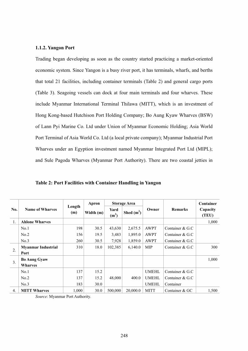
1.1.2. Yangon Port
Trading began developing as soon as the country started practicing a market-oriented
economic system. Since Yangon is a busy river port, it has terminals, wharfs, and berths
that total 21 facilities, including container terminals (Table 2) and general cargo ports
(Table 3). Seagoing vessels can dock at four main terminals and four wharves. These
include Myanmar International Terminal Thilawa (MITT), which is an investment of
Hong Kong-based Hutchison Port Holding Company; Bo Aung Kyaw Wharves (BSW)
of Lann Pyi Marine Co. Ltd under Union of Myanmar Economic Holding; Asia World
Port Terminal of Asia World Co. Ltd (a local private company); Myanmar Industrial Port
Wharves under an Egyption investment named Myanmar Integrated Port Ltd (MIPL);
and Sule Pagoda Wharves (Myanmar Port Authority). There are two coastal jetties in
Table 2: Port Facilities with Container Handling in Yangon
No. Name of Wharves Length
(m)
Apron Storage Area Owner Remarks
ContainerCapacity
(TEU) Width (m)Yard (m2)
Shed (m2)
1. Ahlone Wharves 1,000No.1 198 30.5 43,630 2,675.5 AWPT Container & G.C No.2 156 19.5 3,483 1,895.0 AWPT Container & G.C No.3 260 30.5 7,928 1,859.0 AWPT Container & G.C
2. Myanmar Industrial Port
310 18.0 102,385 6,140.0 MIP Container & G.C 300
3. Bo Aung Gyaw Wharves
1,000
No.1 137 15.2 UMEHL Container & G.C No.2 137 15.2 48,000 400.0 UMEHL Container & G.C No.3 183 30.0 UMEHL Container
4. MITT Wharves 1,000 30.0 500,000 20,000.0 MITT Container & GC 1,500Source: Myanmar Port Authority.
248

Table 3: Port Facilities for General Cargo in Yangon
No. Name of Wharves Length
(m)
Apron Storage Area Owner Remarks
Width (m)Yard (m2)
Shed (m2)
1. Hteedan Rice Berth 139.0 12.5 - 6,688.80 MPA Rice & Rice Products2. Sule Pagoda Wharves No.1 137.0 12.2 6,967.5 5,016.60 MPA General Cargo No.2 137.0 12.2 5,574.0 5,202.40 MPA General Cargo No.3 137.0 12.2 10,683.5 3,855.350 MPA General Cargo No.4 137.0 12.2 3,251.5 6,688.80 MPA General Cargo No.5 160.0 15.2 6,038.5 17,595.26 MPA General Cargo No.6 160.0 15.2 3,251.5 16,062.41 MPA General Cargo No.7 158.5 15.2 1,042.3 13,098.90 MPA General Cargo
3. Port Health Jetty 91.0 12.2 - 4,366.30 MPA General Cargo 4. Hteedan Berth 180.0 21.0 21,738.6 - MEC General Cargo 5. Thaketa Wharves No.1 106.2 19.5
16,294.0 4,462.00 MFSL GC/Coastal
No.2 106.2 19.5 Cargo/Passengers 6. MIPL Wharf 200.0 17.0 20,000.0 3,000.00 MIPL GC/Liquid Bulk Cargo
Source: Myanmar Port Authority.
Yangon, namely Thaketa Jetty and Port Health Jetty, where ships going to Myeik, Dawei,
and Bangladesh are approached.
Normal overseas trade can be conducted only in Yangon, and other exports are
conducted as border trade. The latter is carried out through border trade zones and
border posts designated by the government.
Yangon Port has 24 berths, which are able to accommodate 1,752 vessels a year.
The number of containers handled at Yangon Port has increased by 2.5 times in the
past 10 years. In 1998-99, a total of 108,695 TEUs moved through Yangon but that
increased dramatically to 281,704 TEUs in just 2009-2010. The Asia World Port
249
Terminal, which is located in Ahlone Township, a semi-downtown area, handled 40%
of all container shipments into Myanmar in 2009-2010, followed by Bo Aung Kyaw
Wharves at 30% and MIPL at 18%. MITT held only a 12% market share due to
transportation constraints between industrial zones and the port.
There are advantages and disadvantages between Yangon Port and Myanmar
International Terminal Thilawa (MITT) in terms of location and efficiency. Yangon
Port is situated in the downtown area and has location advantages in being close to
industrial zones as goods can be transported in a short time and at low cost. Myanmar
International Terminal Thilawa (MITT) , however, is located at a disadvatage being in
the Thilawa area 20 kilometers away from industrial zones. Moreover, the road
between the new bridge and MITT is in poor condition. The container transportation
charges are much higher at MITT, contributing to the terminal occupying only a 12%
market share despite having the highest capacity among all port facilities in Myanmar.
As most of Yangon Port is under the state-owned enterprise Myanmar Port Authority,
the port facilities are obsolete and lack sufficient generators. Port operations often stop
when there is an electricity blackout. Among the terminals in Yangon, it is observed
that the Asia World Port Terminal is the most efficient. Another disadvantage for
Yangon Port is its water depth. All berths are situated at the inner harbor, and the
berthing vessels need to pass two underwater sandbars (outer bar and inner bar). The
berth allowance depth is only 9 meters and a vessel’s maximum permissible draft is
subject to the depth of the inner bar, which is shallow in the dry season. Maintaing the
depth of the inner bar is done by dredging every year, which is costly for the Myanmar
Port Authority. The allowabale length of 167 meters is also a constraint for large
vessels.
250
1.1.3. Yangon Port Development Plan
Myanmar, adopting an open market economic system since the late 1990s, has allowed
international trade to increase dramatically over the past two decades. According to the
available data released by the Central Statistics Organization, foreign trade soared
12-fold in terms of value over 20 years. Total trade volume rose from US$956 million in
1989-1990 to US$11,790 million in 2009-2010, establishing an upward trend for
coming years. Myanmar trades with many countries across the world by using sea
transport, and most of the export commodities are transported by ship from Yangon Port,
where import commodities are unloaded as well. In this regard, the port facility should
be efficient and able to handle the loading, unloading, and storage of commodities.
The government of Myanmar has a plan to upgrade Yangon Port swiftly, taking
into consideration the day-by-day growth of commodity flow. The port development
plan is formulated to improve the port facility by building new jetties, constructing a
four-lane road between Strand Road and Yangon River from Htitan Kyatsharsoon to
Botataung Market, and improving the waterway through dredging of Yangon River.
The Myanmar Port Authority is responsible for all seaports in the country. The
Yangon seaport (Yangon Port and Myanmar International Terminal Thilawa (MITT) )
is the largest of all, with the 16 jetties of Yangon Port and the six jetties of Myanmar
International Terminal Thilawa (MITT) totaling 22 where international vessels can
be moored. At present, only 22 vessels can be moored simultaneously and 23.7 million
tons of freight can be handled annually.
In accordance with the port development plan of 2010, projects are under way to
build new jetties in Yangon Port and Myanmar International Terminal Thilawa (MITT).
For the development of Yangon Port, new jetties would be constructed in the area
251

between Thanlyatsoon and Ahlone Sinmin Jetty. The area designated for construction
of 13 new jetties covers 225 acres where 26 vessels could be moored.
Myanmar International Terminal Thilawa (MITT), 37 plots 200 meters in length
and 750 meters in width are being reclaimed, with 28 already settled. On completion of
new jetties in Yangon Port and at Myanmar International Terminal Thilawa (MITT)
facility, there will be 62 jetties where up to 75 vessels can be moored. The port
handling volume will be 100 million metric tons a year. Hence, freight handling
capacity will rise nearly five times.
With a view to improving the waterway of Yangon River, dredging of the river is
being carried out daily at Yangon Port for the convenience of vessels 167 meters long,
15,000 tons in total weight, and 9 meters in draft, and at Myanmar International
Terminal Thilawa (MITT) for vessels 200 meters long, 20,000 tons in weight, and 9
meters in draft.
The Yangon Port Development Plan presents measures to be taken until the port
can cope with 35,000-ton vessels to catch up with commodity flow in the future.
Upon completion of the project, waterways into and out of Yangon Port will be
deep enough for 35,000-ton vessels with a more than 9-meter draft to go along the river.
In addition, port services would be improved to handle the goods promptly with the
increased number of jetties and container yards.
As regards the road construction for transporting commodities to and from Yangon
Port, a new four-lane road between Strand Road and Yangon River would be
constructed with six-feet-wide pedestrian lanes on both sides of the road. The new road
would be 48 feet wide and 4.54 miles long from the Htitan Kyatsharsoon truck yard
and the Botataung Market road, ensuring that container trucks can travel smoothly
252

without traffic congestion on Strand Road. Moreover, there is a plan to build a railroad
along with a new Strand Road.
In order to achieve regular and smooth commodity flow by road from the Yangon
region to the Ayeyarwaddy region and Upper Myanmar, some road sections would be
upgraded into six-lane facilities linking Strand Road and No. 2 Road. This would
enable trucks to run directly to Upper Myanmar through No. 2 Road and to the
Ayeyarwaddy region through the new Strand Road, Kyimyindine Road, and
Bayintnaung Bridge.
As Yangon Port is handling 800 to 1,000 containers a day and most of the port’s
facilities are situated downtown, the traffic congestion in the city is a major issue. In
order to ease the traffic problem and promote the systematic allocation of container
vehicles, a container yard terminal is planned for construction by Dagon Seikan
International Logistics Service Ltd. in the Yuzana Garden City Compound of Dagon
Seikan Township, Yangon Division.
The container yard would have spacious area for accommodating 800-1,000
container vehicles, and other facilities such as office buildings, workshops, and guest
houses. It is located about 15 kilometers from Yangon Port and the terminal at
Myanmar International Terminal Thilawa (MITT).
1.1.4. Airport and Airline Services
Construction of the Yangon International Airport Building began in 1952. The runway,
taxiway, and apron of Yangon Airport was constructed by Denmark-based Christiana &
Nielsan Company (Thai branch), and the old terminal building began operations in 1957.
Before 1988, the old terminal building provided adequate services for all travelers
253

without difficulty, congestion or delay. After 1988, due to the open market economy,
tourist promotion activities, general liberation of air transport, and foreign investment
in the national airline Myanmar Airways International, there was a dramatic increase in
traffic through the old terminal. The number of tourists coming into Myanmar
increased to more than 800,000, compared to 25,000 in 1980, and domestic passenger
travel reached 1.2 million people. Although the Ministry of Transportation and the
Department of Civil Aviation had renovated and extended the old terminal building to
accommodate the increased traffic through the airport, there were still many difficulties
in providing adequate services. Therefore, two new stories were added and an
international terminal building 340 feet in length and 140 feet in width was constructed
by the Public Works Department and put into operation in 1996. Along with the Public
Works Department, the private firm Asia World Co. Ltd was in charge of upgrading the
terminal building and extending the runway from 8,100 feet to 11,200 feet. The
terminal was increased from 340 feet to 800 feet in length and 140 feet in width, while
the airport apron was widened and lengthened by 600 feet in either direction. Due to
the increase in the number of flights and passengers, and power shortages, there are
still problems facing this new terminal.
The construction project for the new terminal building was launched in 2003. The
new terminal building was inaugurated in May 2007. The building’s dimensions are
832 feet in length, 206 feet in width, and 68 feet in height. It can withstand earthquakes
of magnitude 8 on the Richter scale. The new terminal building houses a VIP lounge, a
spacious lobby, waiting lounges at the gates, offices, souvenir shops, cafes, canteens,
and restrooms.
A total of 280 vehicles can be parked at the ground floor and underground parking
254

areas. The new terminal building was equipped with five lifts, three escalators, four
stairs, 12 immigration counters, 30 check-in counters, two transit counters, and five
counters of money changers. The building was fitted with an EM electronic lock
system, card access system, fire protection and warning system, plasma screen
flight-information system, and news and information system. In addition, it has 300
telephone lines. The new terminal building can handle 1,800 passengers per hour and
2.7 million per year. The airport currently has a capacity of five aircraft per hour. The
new terminal building has a total of four passenger-boarding shoots measuring 138 feet
by 10 feet.
Four domestic airlines and 15 international carriers provide service at the airport.
1.1.5. Railway Service
The first railway line in Myanmar was inaugurated in May 1877, carrying passengers
over a distance of 262 kilometers from Yangon to Pyay. Yangon Railway Station was
built in the same year in the downtown area. Total floor area is 5,110 square meters for
serving a million passengers a year. Currently, Yangon provides rail service to cities such
as Mandalay, Naypyitaw, Mawlamyaine, Ye/Dawei, Tharsi, Pyay, and Bago. The
Yangon-Mandalay train runs five times, while the Yangon-Naypyitaw and
Yangon-Mawlamyaine trains run only twice a day. There is a circular train service in
Yangon that caters to commuters. The network has 39 stations that loop around the
various parts of Yangon. Myanmar plans to construct a railway network centered at Nay
Pyi Taw in the near future. The importance of the Yangon railway service will lessen in
coming years.
255

1.2. Mandalay
Mandalay City, the capital of the Mandalay Division, is located on the east bank of the
Ayeyarwaddy River in the Upper Myanmar region. Mandalay City was expanded to
accommodate people migrating in for business opportunities. With more than 1 million
people, it has the second-largest urban population after Yangon. There are five townships
in Mandalay City. The Mandalay Division is situated in the middle of the country, with
overland road access to the China border in the north, the Indian border in the west, and to
the new political capital Na Pyi Taw and Yangon in the south. The city’s primary
functions are as a center for transit trade, a logistics hub, and as a base of manufacturing
facilities. The factories produce consumer and capital goods for markets in the
surrounding states and divisions. These production facilities are situated in the Mandalay
Industrial Zone at the fringe of the city. With the increase in urban population, demand in
consumer goods has climbed along with changing consumption patterns and consumer
behavior. Mandalay is the second-largest urban consumer market in Myanmar. The
conservative social-relationship dynamics, commerce, eating habits, and lifestyles have
changed remarkably over the past few years. As border trade between Myanmar and
China grows year by year, businesses in Mandalay are on the rise because of the
export-import goods passing through the city. In 2009-2010, the volume of
Myanmar-China border trade was US$1,059 million and Myanmar-India border trade
was US$13.7 million. There is a possibility that the border trade between Myanmar and
China could reach US$1,500 million in the near future. Likewise, there is great potential
in the border trade between Myanmar and India.
As regards the regional transportation routes, Mandalay is at the important
junction of Asian Highway Route AH1 from Myawaddy to Tamu and AH14 from
256
Mandalay to Muse. The inhabitants and businesses in Mandalay enjoy the benefits of
growing regional commercial trade due to the city’s strategic geographic location. With
further improvements to the communications infrastructure and highway networks,
Mandalay will become an even more commercially successful urban city.
1.2.1. Mandalay Highway Bus Terminal & Merchandise Center Project
As passenger and cargo vehicles are passing through Mandalay City, the Mandalay
Highway Bus Terminal & Merchandise Center project is planned for establishing a
terminal area between Hton Bo-Myitnge Shortcut Road and Phyut Seik Gone Village in
Pyigyi Tagun Township. The Mandalay Highway Bus Terminal & Merchandise Center
Project has a land area of 65.95 acres. Plans are to construct 360 business-apartments, a
merchandise center for cargo vehicles plying between industrial zones, warehouses,
factories, and the Yatanarpon Cyber City. The intention is to keep cargo in the center
before uploading onto vehicles bound for China and Thailand.
1.2.2. Transportation in the City
From Mandalay, it is easy to travel to various townships with the 243 highway passenger
bus lines leaving from four passenger bus terminals. For highway cargo transport, 279
cargo bus lines provide service from two cargo terminals. There are also 47 bus lines
providing public transportation services centered at Zay Cho in the city.
In Mandalay, only 10% of the 1 million population uses passenger buses for
transportation. Individual transportation is widely popular in Mandalay, such as using
one’s own vehicle, motorbike or bicycle. The number of motorbikes increased from
65,718 in 2003 to nearly 500,000 in 2010, due mainly to the increased issuance of
257
motorbike licenses. Hence, traffic congestion frequently occurs in the Central Business
District of Mandalay. Road discipline and regulations are weak. Mandalay was
constructed in the shape of a perfect square, and where the roads intersect frequently
there is traffic congestion. With a view to reducing road hazards and easing traffic jams,
special roads for motorbike and bicycles have been constructed and one-way roads
have been designated in some areas. Delays in trips often occur due to the speed
limitation of bicycles and even motorbikes. There are 43 bus lines with 1,500 vehicles.
Most traffic congestion occurs at the road intersections of Museum-Mahamuni Pagoda
and Zaychotaw-Kaingdam at 84th Street. To solve the problem of traffic congestion,
intersections between 84th and 85th Streets and 27th and 28th Streets were changed to
one-way roads. Although these are 60 feet wide and could be upgraded to six-lane
roads, it is used as two-way road due to the lapsed practice of traffic regulation and
discipline.
With the increase in vehicles and population, urban roads are being upgraded and
new roads are being constructed in line with Mandalay City Development Council
planning to meet future infrastructure demand. Therefore, 90% of road congestion has
been alleviated but congestion still occurs where road networks were not able to be
expanded in the crowded Central Business District.
1.2.3. Railway Service
Mandalay has one of the largest rail stations in Myanmar. The station is the gateway to
Upper Myanmar, representing 5,031 kilometers of national rail network. The
647-kilometer journey from Yangon to Mandalay is mostly traveled by train due to
dangerous or rough road conditions. There is also riverboat transportation from Yangon
258

to Mandalay along the Ayeyarwaddy but it is much slower than the overland
transportation options. Two local private companies operate railway transportation
services between Mandalay and Myitkyina. Mandalay is on the route of Trans Asian
Railways that connects Thailand with Europe and South and Central Asia via Myanmar.
1.2.4. Mandalay International Airport
Mandalay International Airport (Tadaoo) opened in September 2000 at a cost of US$150
million and represents the largest and most modern international airport in Myanmar. The
maximum capacity of the airport is estimated at 3 million passengers annually. This new
airport occupies a land area of 25,015 acres and boasts a concrete runway 14,000 feet
long and 200 feet wide. It is located in the center of Myanmar about 35 kilometers from
Mandalay. It takes approximately 1 hour to get from the airport to the center of the city. It
is expected that Mandalay International Airport would become a transportation hub for
the region en route to other major Asian cities, particularly Beijing, Hanoi, Bangkok,
Calcutta, and Dhaka.
The terminal building has been equipped with six passenger lifts, one freight lift,
three escalators, and a baggage handling system. There are six passenger-boarding
bridges and three of them can handle modern Boeing 747-400 planes. There is enough
space for 10 planes to anchor and at a rate of eight minutes per plane. The
14,000x200ft runway is large enough to allow any size of commercial airplane to land.
Mandalay International Airport was built to attract international tourists and business
people to the city. The important fact is that with the rate of passenger arrivals in the
past 10 years in proportion to the airport’s size and facilities, it can be assumed that the
infrastructure can cope with 8,000 passengers daily.
259

1.3. Yatanarpon Cyber City
With all of the technological developments around the world, the role of the ICT
(information and communication technologies) sub-sector should be promoted
accordingly. In Myanmar, the establishment of Yatanarpon Cyber City plays a vital role in
the ICT sub-sector. Phase 1 was launched in December 2007 at posted mile 27/0 near
Pyinsa Village, Pyin Oo Lwin Township, Mandalay Division. The Yatanarpon Cyber City
development project has a land area of more than 10,000 acres, with the software industry
area and the hardware industry area allotted 2,500 acres each.
The establishment of Yatanarpon Cyber City was undertaken by the Ministry of
Communications, Posts and Telegraphs. The project was carried out with the belief that
development of the software and hardware industries with up-to-date ICT sub-sector
information would boost Myanmar’s information technology (IT) expertise. The
project is a joint government and private mission to promote investment in Myanmar’s
IT industry.
The area is designated as a special MPT (Myanmar posts and
telecommunications) project zone and is regarded as a vital gateway for local and
international business investment. Through government-sanctioned operational
procedures and long-term investment incentives, it provides qualified infrastructure
such as dedicated high-speed connectivity for all types of investors and developers
both local and from overseas.
Yatanarpon Cyber City started software development with local sourcing and
outsourcing operations by establishing seven “incubation centers.” The rental price for
an incubation center is kyat 200,000 per month, to be reviewed every three years. In
the incubation centers, software developers will have the freedom to implement
260

research projects, IT innovation projects, and system networking designs. Investors in
these high-tech facilities will benefit from government incentives and Yatanarpon
Teleport Company logistical support, and will have first priority in recruiting the best
trained IT personnel from schools in Myanmar.
Since 2007, Yatanarpon Teleport has installed co-location servers and undertaken
webhosting and dial up operations nationwide. Currently, FTTx1 (fiber to the home)
triple play work is being implemented as a pilot project. This will provide a high speed
of Internet service compared to the ADSL connection. At present, 60 lines based on the
FTTx system have been connected in Pyin Oo Lwin. In the future, the FTTx system
would be expanded across the country in cooperation with industries.
For example, a solar cell factory and a fiber optics cable manufacturing facility
were established in the Yatanarpon Teleport zone. Other arrangements were made to
run a soft switch branch section for controlling software industries in October 2010. In
addition, the MCC Training Institute has opened graduate courses to produce
high-quality computer experts holding bachelor of science and business IT degrees.
While carrying out ICT operations, Yatanarpon Cyber City produced CDMA2
800MHz, CDMA 450 MHz telephone handsets, fiber optic cables, BBU3 (base-band
1 Fiber to the x (FTTx) is a generic term for any broadband network architecture that uses optical fiber to replace all or part of the usual metal local loop used for last mile telecommunications. The generic term originated as a generalization of several configurations of fiber deployment (FTTN, FTTC, FTTB, FTTH ...), all starting with FTT but differentiated by the last letter, which is substituted by an x in the generalization. 2 Code division multiple access (CDMA) is a channel access method used by various radio communication technologies. It is the mobile phone system. 3 Base-band unit (BBU): The digital signal processor serves to detect the presence of a second SAT generated by the mobile unit by sampling and processing successive samples of the second SAT and measuring the power thereof.
261

unit) and RRU4 (remote radio unit) antennas and accessories. At present, It is also
producing underground fiber optic cables for the FTTx system, and it will make
overhead fiber optic cables in the near future.
Currently, there are 16 investors doing business in Yatanarpon Cyber City. The
following table shows the number of investors (Table 4).
Table 4: Investor List in Yatanarpon Cyber City
No. Investor Project 1. Thawtarwin Fiber cable, Optical joining connector 2. Yatanarpon Production Co., Ltd Solar cell 3. Tharmoenyae Chanthar Tun Waithar Digital Auto Exchange, Transmission Equipment 4. Asia World CDMA, Cellular BTS 5. Elite Tech Mobile Products 6. FISCA PSTN Exchange Subscriber Apparatus 7. Jade Land Fiber Cable & Connector 8. Hightech Princess Security Product for Communication 9. MCC Group ICT Training Center, Out-Sourcing
10. Myanmar Info Tech Out-Sourcing, Off-shore Programming, R&D 11. MAXINET Software Development, Transmission Equipment 12. Global Technology Sortswitch, Wi-max 13. IGE Computer & Network Accessories 14. Fortune International GPON System1) 15. Yatanarpon Cyber Corporation In-sourcing, Out-Sourcing 16. ITCS Mobile Phone and Accessories Note: 1) GPON (gigabit passive optical network) standard differs from other PON standards in that it
achieves higher bandwidth and higher efficiency using larger, variable-length packets. GPON offers efficient packaging of user traffic, with frame segmentation allowing higher quality of service (QoS) for delay-sensitive voice and video communications traffic.
Source: Yatanarpon Teleport.
4 Radio remote unit (RRU): The remote radio unit includes an active part and a passive part, where the active part and the passive part are placed respectively on an active module and a passive module that are independent of each other and the active module and the passive module are connected via a pluggable connecting device. Because the passive part is more reliable and less liable to breakdown than the active part, when the active part needs to be repaired, it is unnecessary to dismantle the entire unit. Therefore, the repair is easier and faster and the repair cost is lower. The operation reliability of the base station system is also improved.
262

Yatanarpon Cyber City consists of ICT-related facilities such as Technological
University, Yatanarpon Internet Exchange Point-IXP, the Yatanarpon web portal, and
triple play softswitch, all inaugurated in October 2010. Yatanarpon IXP was installed
with the necessary ISP (Internet service provider) equipment to provide Internet
service to the people. Now Internet users can visit the web portal of their choice,
whereas in the past they had to rely on the websites of providers in foreign countries.
Triple-play service provides Internet, telephone, and video IPTV (Internet protocol
television) to users through communication media. Although Yatanarpon Cyber City is
being built for development of ICT, the accessibility and reliability of Internet services
are still questionable as the facilities are under the control of the Ministry of
Communications, Posts and Telegraphs.
1.4. Mawlamyaine
Mawlamyaine, the capital of the Mon State, was the third-largest city after Yangon and
Mandalay before Nay Pyi Taw became the capital of Myanmar. It is one of the townships
of the Mawlamyaine District. The main transport route, the 180-mile
Yangon-Mawlamyaine Road, extends to Dawei as the Mawlamyaine-Dawei Road. The
land area of Mawlamyaine Township is about 50 square miles, covering 22 wards, 19
village tracts and 48 villages. The population of Mawlamyaine City proper is 202,000
people and that of the whole township is estimated at 464,000. About 1,600 businesses,
excluding factories in the industrial zone, are operating within the city area.
High-speed public coastal passenger crafts are available from Yangon to
Mawlamyaine, Dawei, Myeik, and Kawthaung in the south. In addition, cooperative
and privately owned schooners carry goods and passengers along the Yangon,
263

Mawlamyaine, Myeik, and Kawthaung coastal route. Altogether, 12 pontoon jetties are
found in the city, including seven jetties for public use but these are very old and rarely
used by small vessels. Air transportation service between Yangon and Mawlamyaine
was suspended for a long time due to many reasons, one of which is that road and
railway transport are more convenient and less expensive. Travel by train to
Mawlamyaine is so much easier now with the inauguration of the new Mawlamyaine
railway station in 2006. After completion of Thanlwin River-cross Railway Bridge, the
longest at 2 kilometers, transportation by train on the Yangon-Mawlamyaine route
became smoother, less costly and more time-saving.
Mawlamyaine was a busy commercial city in the past based on border trade
activities, due to its geographic proximity to the Thai border and accessibility via the
river. Mawlamyaine was a bustling port in British colonial times. It was also
prosperous during the time of the socialist government from the 1960s to the early
1990s due to the emergence of black market smuggling operations. Today,
Mawlamyaine is no longer a vital commercial city because the trade route from Mei
Sot to Myawaddy bypasses Mawlamyaine through the town of Hpa-an and on to
Yangon. In addition, huge cargo from Thailand through Kawthaung at the southern tip
of Myanmar is directly transported by sea to Yangon, circumventing the Mawlamyaine
port facilities.
For the success of the East-West Economic Corridor, the ports at the eastern and
western ends of the corridor play important roles. At the eastern end is the Da Nang
Deep-Sea Port with supportive services provided by Tien Sa Seaport and Han River
Port, and it has a throughput capacity of 4 million metric tons a year.
At the western end of Mawlamyaine, there were preliminary plans for the
264

construction of a deep-sea port. These plans were deemed unfeasible due to
geographical constraints and technical limitations. Mawlamyaine Port is designated as
one of eight coastal ports in Myanmar by the Myanmar Port Authority. But the
Myanmar Port Authority has already acknowledged that maritime access to
Mawlamyaine Port is not deep enough for vessels of more than 4.5 meters in draft.
Besides, it is 20 knots away from the mouth of Than Lwin River, which makes the port
difficult to access by coastal ships. The coastline of the Mawlamyaine jetty area is 3
kilometers long, and the area is packed with seven small jetties which are suitable for
trawlers and ferry boats traveling to nearby places.
Therefore, Mawlamyaine will not be the western end of the East-West Economic
Corridor. The present route for border trade is from Yangon to Bago, Thaton, Hpa-an,
and Myawaddy. The trade between Myanmar and Thailand through the Myawaddy
Trade Zone totals about US$150 million a year according to Myanmar official figures,
but it is probably US$300 million or more in actual value. The East-West Economic
Corridor should not end at Mawlamyaine as projected, and the corridor could be
extended to Yangon through the Hpa-an route as there are international port facilities
available in Yangon, especially at Thilawa. However, the road between Yangon and
Myawaddy should be upgraded to be suitable for heavy trucks.
1.5. Dawei
Dawei, formerly known as Tavoy, is a city in southeastern Myanmar. It is the capital city
of the Tanintharyi Region, formerly called the Tanintharyi Division, situated
614.3 kilometers south of Yangon on the northern bank of the Dawei River. Dawei
Township is part of the Dawei District, which consists of four townships and an area of
265

5,308 square miles, where 210,000 people reside. Being a coastal area, Dawei is in
between a mountain range lying at the east going north to south, and the Andaman Sea.
Dawei is 384 miles from Yangon and 187 miles from Mawlamyaine. Passenger buses run
from Dawei to Yangon every day. The trip takes 24 hours as the road is bad between
Dawei and Ye. There are several trucks in the bus terminal which generally carry rubber,
cashews, and betel nuts from Dawei to Yangon, and various commodities are also carried
from Yangon.
There is a railway line between Dawei and Mawlamyaine stretching 200 miles,
with daily service. In 2009-2010, the railway carried 38,000 passengers. A new rail line
is under construction from the Dawei train station to Dawei Port.
There are two old ports in Dawei and one in Thayetchaung. The Dawei River is
narrow and not suitable for coastal ships. Shin Phyu Pyin Port, 25 miles away from
Dawei and within Thayetchaung Township, was built in 1960 for coastal ships. This
port has two 120-foot pontoon jetties where passengers and cargo ships from the Five
Star Line and fuel ships from the Ministry of Energy berth two or three times a month.
There are three shuttle boats plying daily between the Shin Phyu Pyin Port of Dawei
and Myeik Kawthaung. Daily flight service is provided for the Yangon-Dawei route by
three local airlines: Yangon Airways (three flights a week), Air Bagan (four flights a
week), and Myanmar Airways (five flights a week).
1.5.1. Dawei Deep-Sea Port Project
The Dawei Deep-Sea Port project was started after the signing of an MOU at the special
meeting of the ASEAN foreign ministers in Singapore on 19 May 2008. The foreign
ministers of Myanmar and Thailand signed the MOU on implementation of the Dawei
266

Deep-Sea Port and Industrial Estate, and road and rail links to Thailand.
Later, the MOU was signed between the Myanmar Port Authority and Italian-Thai
Development Public Company Limited on 12 June 2008. Italian-Thai Development
kicked off preliminary studies and the site surveys in June 2008. This includes the
geotechnical survey and the topographic survey. The scope of preparation work in
2010 is:
1) Small port
2) Soil boring at deep-sea port basin
3) Accommodation and site office
4) Trans-border rail link
5) Nabule-Phu Nam Ron Road
In regard to the geographic review, Italian-Thai Development believes that the
proposed project area will become an Asian regional hub linking to China and
Southeast Asia, India, the Middle East, Europe, and Africa. It is at the end of the
Southern Economic Corridor of the Greater Mekong Subregion, and a gateway to the
Indian Ocean. Along the Southern Economic Corridor, one route is from Dawei to
Kanchanaburi, Bangkok, Sisophon, Siem Reap and then Quy Nhon, and another way
goes to Phnom Penh, Ho Chi Minh City and Vung Tau.
Italian-Thai Development has assessed this area as a good location for deep-sea
port development due to the following facts:
1) Natural water depth able to accommodate large vessels
2) Natural shelter good for anchorage
3) No physical underwater and sub-soil obstructions for approach channel and port
basins
267

4) Sufficient flat hinterland for the industrial estate in order to support throughput for
the port
5) Economical transportation on roads and rail links between Dawei and Thailand
6) Sufficient local supply of construction materials
According to the port plan, vessels can approach through navigation channel and
fair ways to port areas. The development project has two port areas as follows:
1) The deep-sea port north area covers 2.7 square kilometers, with a
1.5-square-kilometer cargo yard and a 1.4-square-kilometer shipbuilding yard.
2) The deep-sea port south area covers 3 square kilometers, and a 1.5-square-kilometer
agriculture yard is included.
On 2 November 2010, the managing director of the Myanmar Port Authority and
the chairman of Italian-Thai Development signed the framework agreement on
implementation of the project for the Dawei Deep-Sea Port and Industrial Estate, and
road and rail links to Thailand.
Port facilities and industries are well linked under the project and Italian-Thai
Development estimates that the steel industry will be supported by bulk port, requiring
throughput of iron ore, coal, and other materials, and will export its own finished
products totaling 40 million tons a year. The port will handle 5 million tons of
agricultural products such as rice, sugar, corn, tapioca, and other grains per year.
Imports of coal will reach 25 million tons a year. The port will handle 3.2 million
TEUs a year, which is equivalent to 45 million tons, 50 million tons of general cargo,
35 million tons of chemicals and petrochemicals, and 36 million tons of crude oil. The
handling capacity of the port is 200 million tons a year.
Dawei Port is 370 kilometers from Bangkok and 70 kilometers to the border at
268

Kanburi. It needs a corridor link to Thailand to include roads, railways, transmission
lines, and oil and gas pipelines. The right of way of the proposed corridor is a 40-meter
8-lane highway, 25-meter double railway lines, a 60-meter transmission line, and oil
and gas pipelines totaling 200 meters. There will be a bridge crossing Dawei River and
a tunnel for a rail link in the mountainous area. The rail link can extend from Dawei to
Kunming, China, approximately 1,700 kilometers.
The construction period for the Dawei Deep-Sea Port and Industrial Estate
trans-border link will be at least 10 years. The project has three phases of five years each.
The first phase of infrastructure construction will start in 2011.
The eastern coastline of Dawei is regarded as the area with the most potential as it
is the end of the GMS Southern Economic Corridor and is a hub connecting to GMS
countries, South Asia and Southeast Asia. There is large potential to develop the
deep-sea port and other businesses due to the geographic location. The objective in
developing the Dawei Deep-Sea Port is to promote trade, investment, tourism, fishery,
mining, natural gas, and other industries by launching integrated area development that
will benefit Myanmar and Thailand. The port will benefit not only these two countries
but also many other countries along regional and international trade routes. The
development of the deep-sea port will enhance the promotion of trade and investment
among ASEAN and neighboring countries.
Italian-Thai Development has much confidence in their conceptual plan and is
looking forward to finding investors who will come and join the plan. The dream of
developing the deep-sea port project might face two types of challenges as follows:
269

1) Internal challenge – Achieving the project will depend on the political climate and
trade and business relationships between two countries. Even so, the most important
factor will be the security risk along the corridor of the trans-border link.
2) External challenge – The external challenges are the degree of investors’ confidence
in the project, competition from the efficiency of Singapore’s port, and changing
conditions of international sea routes and trade routes. Total regional trade passing
through Myanmar from neighboring countries was estimated at US$84 billion in
2009. Italian-Thai Development has to calculate how much Dawei Deep-Sea Port
will attract from that figure and the extent of the challenge from other alternative
trade and maritime routes such as Jakarta, Indonesia.
2. INDUSTRIAL ZONES IN MYANMAR
Since adopting a market-oriented economic system toward building a modern developed
nation, Myanmar has carried out liberalization measures to enhance private-sector
participation in the process of economic development. These measures have had a
significant impact.
As regards the industrial sector, measures such as allowing more private sector
participation through the relaxation of private investment registration, promotion of
cottage industries, and promotion of privatization have been undertaken to encourage
development of the sector. Myanmar is an agrarian country and its economy depends
almost wholly on the agricultural sector, while the industrial sector’s share of the
national GDP is not more than 20%. Myanmar aims to follow in the footsteps of
newly-industrialized countries in the region as far as promoting the share of the
270

secondary sector in the national GDP. In this regard, the government established the
Myanmar Industrial Development Committee (MIDC) to support industrial
development by appropriate means. As a consequence, the number of private-owned
industries increased from 26,690 in 1998 to 43,789 in 2009, which includes 10,879
cottage-industry enterprises. As far as employment is concerned, the number of
industrial laborers climbed to 3,485,264 in 2009, up from 1,224,363 in 1988 on an
annual growth rate of 2.8%.
One of the steps by the MIDC has been to set up industrial zones in the outskirts
of cities and towns in various states and regions where there are sizeable numbers of
private small and medium-sized industries (SMIs). Eighteen industrial zones have been
established in Myanmar, with four zones and 14 industrial parks in Yangon and an
additional 14 zones in 14 local cities (Figure 1). The total number of industries in the
18 zones are 10,347. Some 44% of total establishments are located in Yangon,
followed by Mandalay with 11%. While large-scale industries occupy most of the area
in the industrial zones, it issmall-scale industries that make up the majority of
registered private industries throughout the country. According to the Private Industries
Law 1990, industries are divided into three groups: large, medium and small. The
Promotion of the Cottage Industry Law 1991 expressed that small-scale industries
which use power at less than three HP or manpower not exceeding nine workers, and
handicrafts in which the number of workers is not limited are called cottage industries.
Industry classification by size is shown in Table 5.
271

Figure 1: Map of Industrial Zones in Myanmar
Source: MIDC.
Table 5: Industries Classification by Size Particular Small Medium Large Machine Power (HP) 3-25 26-50 50 above Work force 10-50 51-100 101 and above Capital outlay (Kyat million) Up to 1 1-5 Over 5 Production value (Kyat million) Less than 2.5 2.5 to 5 Over 5 Source: Private Industries Law, 1990.
272

In Myanmar, there are more than 40,000 registered industries, most of which are in
the Yangon region, either within or outside of industrial zones. According to the
available data, 14 industrial zones have been established in the Yangon region to
accommodate various kinds of companies owned by national citizens and foreigners
for the manufacture of industrial products provided with standard infrastructure
services.
2.1. Industrial Zones in Yangon
Industrial Zones in Yangon (Figure 2) are divided into four types: FDI, joint venture, local
privately owned, and local government-owned. A comparison of the industrial zones is
shown in Table 6.
The regulations and services provided in the industrial zones differ among the
industrial zone management committee. Some just provide standard facilities. The
annual land rent and land use premium are also not the same depending on factors such
as location and infrastructure.
The Mingaladon Industrial Park (23 kilometers north of the Yangon city center),
Yangon Industrial Park Tharketa Industrial Zone, Dagon Myothit South South Dagon,
South Okkalapa, and Hlaing Thar Yar Industrial Zone are favorable zones (Figure2).
Shwe Pauk Kan, Myaung Da Kar, Shwe Pyi Thar, and Shwe Lin Pan are less favorable
zones. As for the land area, the Hlaing Thar Yar Industrial Zone is the largest with
1,401 acres, followed by Shwe Pyi Thar at 1,300 acres, Dagon Seik Kan Port at
1,208.6 acres, Shwe Lin Pan at 1,100 acres, and Yangon Industrial Park at 989.6 acres.
The remaining zones are not of significant land area.
273

Figure 2: Map of Industrial Zones in Yangon
Source: MIDC.
274

Table 6: Comparison of Industrial Zones in Yangon by Types (Continues)
No. Type of Industrial Zone
Foreign Direct Investment FDI
Local Private JV (Foreign + UMEHL)
Local + DHSHD
1. Year of establishment
1998 2000 1991 1990
2. Number of Industrial Zone
1 1 1 15
3. Developer DHSHD & Mitsui & Co., Ltd
Zaykabar Company Limited
Myanma Economic Holdings LTd.
DHSHD
4. Infrastructure 1) Electricity
Deposit- US$25 kW to YESB
Transformer is installed by Zaykabar Co., Ltd for public Area
Tenant will arrange own transformer for factory.
Own arrangement through zone committee
(b) Charges (i) Foreign
US$ 0.08/kWh + 10% costing + capacity charges
US$ 0.08/kWh + 10% costing + capacity charges
US$ 0.08/kWh + 10% costing + capacity charges
US$ 0.08/kWh + 10% costing + capacity
(ii) Local - Ks 50/kWh Ks 50/kWh Ks 50/kWh 2) Water
a) provided by Developer
total supply capacity of 5000 m3/day from 15 deep wells
Tenant digs own tube-well and water supplied by YCDC
Water pumped deep wells within their own compound.
to be dug own tube well
b) Charges US$ 0.50/m3 US$ 0.70/m3 (Treated water charges)
For Joephyu water, Ks. 77/unit ( 0.06 US$/unit)
Nil Own tube well
3) Waste Water Treatment
Capacity 5,000 m3/day
Nil Self development if necessary
Nil
4) Telephone/Fax Line a) provided by Developer
Auto 300 Lines. (34 lines already used and 265 lines ready for installation)
PABX system MEHL will assist if necessary in acquiring permissions from MPT
Own arrangement through Zone Committee
b) install installation fee
US$ 2000/line Ks. 500,000/ extension line (uS$500/line)
- US$ 1500/line
c) Line phone Charges (i) Overseas
in US$ (depend on country)
in US$ in US$ in US$
275

Table 6: Comparison of Industrial Zones in Yangon by Types (Continued)
No. Type of Industrial Zone
Foreign Direct Investment FDI
Local Private JV (Foreign + UMEHL)
Local + DHSHD
(ii) Local
US$ 0.15/minute in US$ (for over sea call) Ks.25/minute (for local call)
in US$ (for over sea call) Ks.25/minute (for local call)
in US$ (for over sea call) Ks.25/minute (for local call)
5) Roads Concrete main Rd. (8m wide) Concrete subroads (7m wide)
Concrete main Rd. (5.5 m wide 2 lane) Concrete main Rd (2.7 m wide 2 lane)
There is no need to construct the road as it locates beside No.3 Highway Road.
Concrete roads (6m wide)
6) Estate Security for whole IZ
Provided (24 hours) security service
Provided (24 hours) security service
Not provided Not provided
5. Services Provided
Maintenance of estate utilities, Landscaping and 24 hour security service, Business support services and any other consultations
Maintenance of estate utilities, Landscaping and 24 hour security service, Business support services and any other consultations
Nil Industrial zones are established as industrial towns so that factories are mixed with housing
6. 1) Management fees
US$ 0.04/m2/month Nil Nil
2) Maintenance Fees
Nil Ks. 12,000/factory/mth (US$ 12/mth)
For Foreign (US$ 20/Acre/month) For Local (Ks.3000/Acre/month) (US$0.0007/m2)
3) Zone Committee Fees
Nil Ks. 500/Acre/mth (US$0.0001/m2/mth)
Ks. 364/acre/mth (US$ 0.00009/m2/mth)
4) Annual Land Rental fee
US$ 0.30/m2/yr (reviewing max. 15% every 5 years)
Ks. 364/acre/mth (US$ 0.00009/m2/mth)
It is paid by UMEHL
276

Table 6: Comparison of Industrial Zones in Yangon by types (Continued)
No. Type of Industrial Zone
Foreign Direct Investment FDI
Local Private JV (Foreign + UMEHL)
Local + DHSHD
7. Land Lease Period a) Foreign
60 years (leasehold until Feb-2048, transferable)
5 years, Extenable 5 yearly up to 30 years
(lease hold for 30 years, extendable)
b) Local 60 year grant 60 year grant 8. Land Use
Premium a) Foreign Invester
US$ 4/m2/ yr (under plan)
US$ 3/m2/year US$ 3/m2/year (UMWHL invests the capital in kind in share (i.e industrial land) as JV Minium
US$ 3/m2/year (increase max, 15% every 5 year
b) Local Nil Ks. 40-50 million/acre=US$ 9.88-12.36/m2
US$ 2/m2/year Ks. 100-325 million / acre = (US$ 24.7-80.31)/m2
9. Payment Terms for land Use Premium
3 Installments 1) 10% on booking 2) 50% (upon singing of sub-lease agreement) 3) 40% (upon signing of physical delivery receipt)
4 Installments 1) 40% 2) 20% 3) 20% 4) 20% (All charges are paid within 3 month)
3 Installments 1) 50% 2) 25% 3) 25%
3 Installments 1) 50% 2) 25% 3) 25%
Notes: UMEHL- Union of Myanmar Economic Holding limited, DHSHD- Department of Human Settlement and Housing Development.
Source: Based on documents provided by the Mingaladon Industrial Park.
277

Owing to their favorable location and facilities, the Hlaing Thar Yar, Shwe Pyi
Thar, Dagon Seik Kan, and Shwe Lin Pan zones have sold out all of their land plots for
industrial establishments.
Infrastructure development and facilities constitute key factors in assessing the
quality and standard of services provided by the industrial zones. Pertaining to the
infrastructure facilities, the water supply, power supply, and road and communication
facilities are decisive elements of the infrastructure. The main sources of the water and
power supplies are Myanmar Electrical Power Enterprise, Electrical Supply Enterprise,
and Yangon City Development. As the demand and the supply of water and electrical
power are not equalized, most of the industrial zones have supportive measures to
bolster the water supply and electrical power, including the digging of tube wells,
establishing electrical substations, transformers and transmission lines, and placing
stand-by generators. For instance, Dagon Myothit South South Dagon has installed
four 500KVA power substations, a 750KVA generator, and a high-tension cable 3,696
feet long. For sufficient water supply, it set up two underground 10,000 gallon water
tanks and dug three tube wells. Similarly, the Hlaing Thar Yar Industrial Zone has
10MW/11KVA substations, stand-by generators, and sufficient water supply with tube
wells. Yangon Industrial Park has 10MW/11KVA substations and a 100KVA
transformer, and for sufficient water supply it dug its own tube wells.
For better communications, zone management committees have their own
arrangements for communicating within the zone and contacts to the outside. Among
the industrial zones, Mingaladon Industrial Park has 300 auto lines, Yangon Industrial
Park has a PSPX system, and the Shwe Pauk Kan Industrial Zone has 450 auto lines,
117 GSM mobile phones, and 80 sets of CDMA.
278

Road conditions are generally fair as every industrial zone has concrete roads wide
enough for heavy vehicles to travel along. However, roads can be bad in the rainy
season, and there also might be disrepair in the open season.
As mentioned previously, the land rents of the industrial zones are different. The
land rent at Mingaladon Industrial Park is US$0.30/m2/yr. Yangon Industrial Park,
Hlaing Thar Yar, Shwe Pyi Thar, and Dagon Seik Kan all have the same rate of
US$0.00009/m2/month.
The land use premium and the lease period are also important to foreign investors.
The land use premiums and the lease periods are US$40/m2 for a full-term lease
(leasehold until February 2048, transferable) at Mingaladon Industrial Park,
US$3/m2/yr and US$9.88/m2 (for a 60-year grant) at Yangon Industrial Park,
US$3/m2/yr (minimum five years up to 30 years) at the Pyinmabin Industrial Zone, and
US$3/m2/yr (leasehold for 30 years extendable) at Dagon Seik Kan.
The South Dagon Industrial Zone ranks first in number of companies with 1,401,
followed by Hlaing Thar Yar with 511 and Shwe Pyi Thar with 228 companies. There
are 19 kinds of industrial groups operating in the industrial zones. Among the groups,
the garment, food processing, and household goods companies together make up the
majority, representing more than 75% of total enterprises.
An industrial zone management committee is formed in every industrial zone to
supervise and facilitate the day-to-day operations of companies, and to implement the
short-term and long-term targets on upgrading the zone in accordance with
international standards.
279

2.2. Mandalay Industrial Zone
In 1990, the Mandalay Industrial Zone project was started to encourage industrial
development. The government designated the site on the Yangon-Mandalay Road’s
eastern side, namely Yar Taw. The new industrial town was put under the administrative
area of Pyi Gyi Ta Kon Township as Industrial Zone 1. In 1998, Sein Pan industrial
establishments were moved to the new San Pya industrial town and this became Industrial
Zone 2. In Industrial Zone 2, Mandalay Royal Industrial Co, Ltd. has advanced industrial
machinery and equipment. These include vertical lathes using heavy machines, and
milling and gear hobbing machines for gear and pinion production. There is a forging
machine for boiling raw iron sculpture in the electrical and iron boiling factory. The Good
Brother Co., ltd. factory also produces transportation vehicles and agriculture implements.
Other factories also make agricultural equipment such as bulldozers, excavators, lathes,
and boats.
The Mandalay Industrial Zone is located in Pyi Gyi Tagon Township with a land
area of 1,249.33 acres and 3,140 land plots. There are 1,159 enterprises, including 317
large, 232 medium-scale and 610 small companies (Table 7). For administration
purposes, the area is divided into two parts as the ward of Industrial Zone 1 and the
ward of Industrial Zone 2 in Pyi Gyi Tagon Township. However, there is only one
Industrial Zone Management Committee.
280

Table 7: Industries in Mandalay Industrial Zone by types of business
No. Type of business Total Business
Large Medium Small Total 1. Food Stuffs businesses 104 57 20 181 2. Clothing businesses 10 3 2 15 3. Construction 25 1 5 31 4. Consumer goods 25 7 6 38 5. Household commodities 15 6 1 22 6. Printing and Production 12 1 11 1 7. Raw materials 46 8 78 31 8. Chemical and Energy 3 39 4 163 9. Agriculture equipment 32 1 9 8 10. Machines and Spare Parts 45 4 1 9 11. Transportation - 105 473 32 12. Electrical equipments - - - 5 13. General industries - - - 623
Total 317 232 610 1,159 Source: Mandalay Industrial Zone Management Committee.
2.3. Mawlamyaine Industrial Zone
With the third-largest population in Myanmar, Mawlamyaine plans to develop industries
by establishing an industrial zone. Kyauktan Village, the land area at the side of the
Mawlamyaine-Ye railroad, was first chosen as the site for the Mawlamyaine Industrial
Zone. But it is farmland that floods frequently in the rainy season, which would require
heavy investment. Therefore, it was deemed an inappropriate site for construction. After
the opening of the Attaran Suspension Bridge on 26 March 1998, the Myanmar Industrial
Construction Service, Ministry of Industry, instead chose to prepare land for the industrial
zone at Nyaungbinseik Village, Kyaikmgyaw Township on the Mawlamyaine-Phan Road
some 1,600 feet away from the bridge and five miles from Mawlamyaine. This has only
281

207 companies, of which most are engaged in industrial raw materials such as rubber.
Due to insufficient infrastructure and technology, the development of this zone is not
found to be significant (Table 8).
2.4. Dawei
The Dawei Deep-Sea Port and Industrial Estate, and road and rail links to the Thailand
Construction Project will be the first-ever special economic zone in Myanmar. The Dawei
Deep-Sea Port and Industrial Estate is expected to cover an area of 250 square kilometers
or 61,775 acres. The project will require spacious land to avert industrial congestion and
environmental problems, and for future expansion. The industrial estate has five planned
zones as follows (Figure 3):
Table 8: Number of Business in Mawlamyine Industrial Zone
No. Industrial Total Business
Large Medium Small Total 1. Food and Beverages 9 42 - 51 2. Clothing and garment - 2 - 2 3. Construction materials 2 1 - 3 4. Consumer goods 6 11 - 17 5. Household good 1 1 - 2 6. Industrial raw materials 6 3 - 99 7. Metal and oil products - 19 1 20 8. Electronic - 1 - 1 9. Transportation service 20 - - 20 10. General 3 67 12 82
Total 47 147 13 207 Source: Mawlamyine Industrial Zone Management Committee.
282

Figure 3: Industrial Estate Plan
Source: The presentation of ITD at Dawei Deep-sea Port Site on July 20, 2010.
1) Zone A - Heavy industry zone (38.3 square kilometers) including a coal-fired power
plant, steel mill, and fertilizer, ship-building, and cargo yards, as well as the deep-sea
port;
2) Zone B - Heavy industry zone for oil and gas storage, with an oil refinery, gas
separation plant, and compound circled power plant;
3) Zone C - Medium and heavy industry zone (44.7 square kilometers) for the upstream
and downstream petroleum industries;
4) Zone D - Medium industry zone (58.6 square kilometers);
5) Zone E - Light industry zone (43 square kilometers); and
283

6) Public area (13.5 square kilometers) for a commercial complex, authority center, and
township and district offices.
According to the project plan, a power station that can generate 4,000MW will be
constructed for the whole estate. The industrial estate will need at least 300,000 cubic
meters of raw water per day. A reservoir will be built to provide 100 million cubic
meters to the estate during the four months of the dry season. The motor road and
railway, each 160 kilometers long that will link the Dawei Deep-Sea Port to the
Myanmar-Thai border will be built in phases (Figure 4). The road will reach the GMS
Southern Economic Corridor that leads to Vung Tau and Quy Nhon in Vietnam through
Sisophon of Cambodia via Bangkok, Thailand. The 220-meter-wide road includes an
eight-lane highway together with the railroad, pedestrian lane, local road, Union Road,
and traffic islands. Oil and natural gas pipelines will be laid parallel to the motor road
and railway.
Myanmar developed its Special Economic Zone Law in early 2005 and plans to
establish a special economic zone in the Thilawa area near Yangon City. However, the
law has not been enacted due to objections raised by local industrialists who are
demanding to be granted privileges similar to those offered to foreign investors in the
zones. Furthermore, the government has been occupied with the task of transforming
Nay Pyi Taw into the capital of Myanmar. Enactment of the law has been suspended
since then. Now the project is officially known as the Dawei Deep-Sea Port project, the
first special economic zone in Myanmar without being under the rule of this law. Of
course such a project would not be realized overnight. But Myanmar would earnestly
prepare to meet the challenges arising from constructing a deep-sea port of
international standard.
284

Figure 4: Dawei Deep Sea Port Plan
Source: The presentation of ITD at Dawei Deep-sea Port Site on July 20, 2010.
CONCLUSION
This study has examined some aspects of the infrastructure readiness of major cities in
Myanmar which will physically link to economic corridors and the regional
transportation network, where economic corridors enhance the integration of the
economic activities of the region.
Accordingly, this study has attempted to analyze industrial estates, city
transportation, port facilities, airline services, and water transportation infrastructure
with data collected in Yangon, Mandalay (including Yatanarpon), Mawlamyaine, and
285

Dawei.
Yangon is now Myanmar’s major commercial center, where most of the industrial
zones have been established and the transportation infrastructure is the best of all cities.
Establishment of the international airport and the Yangon Port Development Plan may
support and enhance trade and industry with better logistic facilities. Yangon is the
most favorable city to be the western end of the East-West Economic Corridor, instead
of Mawlamyaine which was envisaged as such in the previous plan.
As regards Mandalay, it is the commercial hub in Upper Myanmar with great
potential to raise the national income through trade, especially border trade with China
and India. In addition, Yatanarpon Cyber City was established 20 miles away from
Mandalay and this will undoubtedly escalate the economic growth not only in
Mandalay but also in the country as a whole.
The study illustrates that Mawlamyaine will become a city on the route of the
extension road and railway from Dawei to Yangon and elsewhere in Myanmar. In
addition, Dawei is an economically promising region due to its potential as a deep-sea
port and special economic zone at the end of the extension of the Southern Economic
Corridor, which will facilitate Myanmar’s integration into the regional and
international economic community.
This study provides to some extent the necessary data and information for
development targets in the implementation of the East-West Economic Corridor and
Southern Economic Corridor development projects. The current study was specifically
designed to evaluate factors related to the historical background and the current
situation. Therefore, further research is recommended regarding development of the
infrastructure in major cities and their networks, as well as the development of projects
286
related to the economic corridors that serve as gateways to economic development for
Myanmar and its neighbors.
287