Embed Size (px)
Citation preview
A':
J,
HATtr fl ________r'---'-r-\-~II
'+--RI\' I:
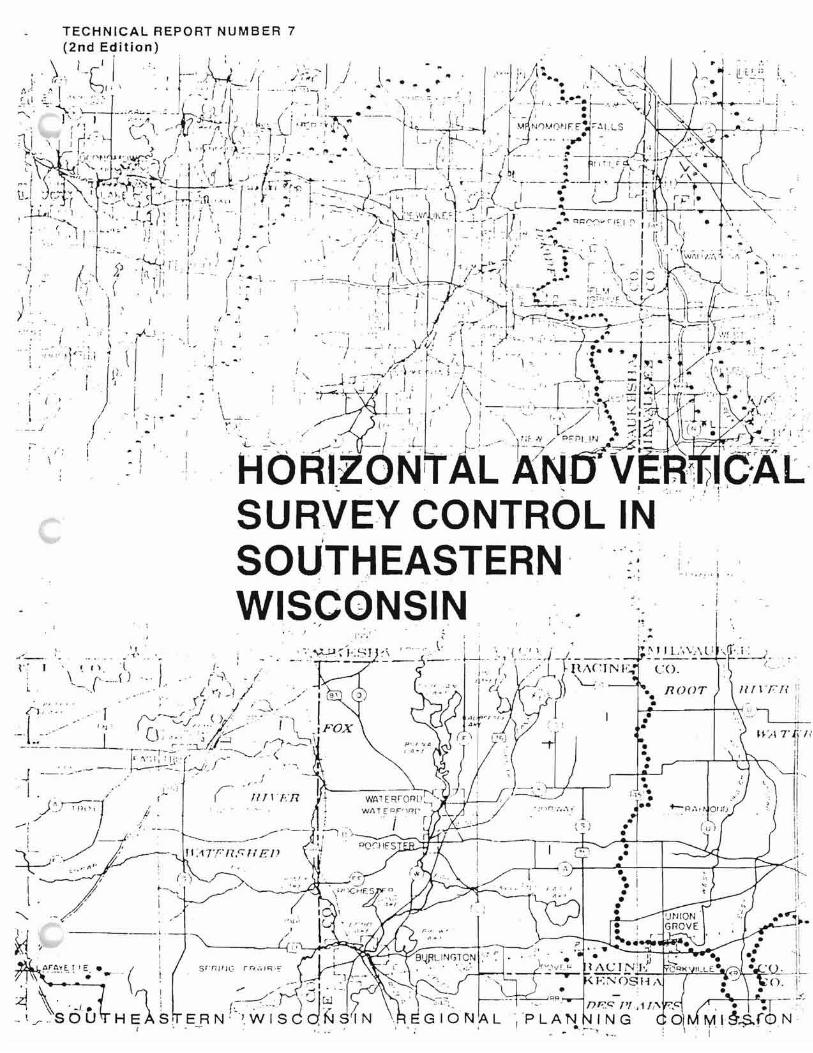
TECHNICAL REPORT NUMBER 7 SECOND EDITION
HORIZONTAL AND VERTICAL SURVEY CONTROL IN SOUTHEASTERN WISCONSIN
Prepared by the
Southeastern Wisconsin Regional Planning Commission P. O. Box 1607 Old Courthouse
916 N. East Avenue Waukesha, Wisconsin 53187-1607
The preparation of this publication was financed in part through planning funds provided by the Wisconsin Department of Transportation; and the U. S. Department of Transportation, Federal Highway and Urban Mass Transportation Administrations.
August 1990
Inside Region $25.00 Outside Region S50.00
AppendixB
DETAILED SPECIFICATIONS FOR CADASTRAL MAPPING
Appendix 8-1
DETAILED SPECIFICATIONS FOR ONE INCH EQUALS 100 FEET SCALE CADASTRAL MAPPING
1. GENERAL
These specifications set forth the requirements of the of for cadastral mapping services. The Consultant shall furnish all labor, materials, and equipment necessary to properly complete the work specified herein.
II. CADASTRAL MAPS
A. General The shall furnish to the Consultant predrafted base map sheets in the form of reproducible copies having a matte finish on both sides prepared on dimensionally stable polyester base material having a minimum thickness of 0.007 inch. Each sheet shall measure 36 inches by 36 inches overall and shall cover one U. S. Public Land Survey quarter section at a scale of one inch equals one hundred feet (1" = 100').
B. Predrafted Data The following data shall be shown on the predrafted base map sheets by the _ prior to delivery to the Consultant:
1. All section and quarter-section lines and corners together with their grid and ground level lengths and grid bearings, all in their correct position and orientation. The section and quarter-section lines and the type of monument marking the section and quartersection corners shall be indicated by appropriate symbols and a legend.
2. A north point based upon grid bearing shall be shown on its correct orientation on each base map sheet. The angle between geodetic and grid bearing (theta angle) shall be shown on each base map sheet, and shall represent an average value for the area covered by the map sheet.
3. A combination sea level and scale reduction factor shall be given on each sheet for the reduction of measured ground lengths to corresponding grid lengths on the Wisconsin State Plane Coordinate System. The factor shall represent an average value for the area covered by the map sheet.
4. A basic map projection, consisting of the intersections of grid lines on the Wisconsin State Plane Coordinate System. The grid line intersection tick marks shall be shown on the base map sheets at five (5)-inch intervals conforming to the even 500-foot interval coordinate values east and north of the base lines.
5. Sheet borders and a title block, with the latter containing a graphic scale and the following information: type of map; location by U. S. Public Land Survey township and range, county, and state; the name of the Consultant preparing the map, and appropriate sheet numbers.
6. Selected topographic features useful to the plotting or construction of real property boundary lines from legal descriptions, such as the threads of major streams and watercourses, fence lines, pavements, and principal buildings.
85
-----
C. Precision and Accuracy Standards-Predrafted Data The base map sheets as provided to the Consultant by the shall meet the following standards of precision and accuracy:
1. Each grid tick shall be plotted within 1/100 of an inch of the true state plane coordinate values.
2. Each U. S. Public Land Survey section and quarter-section corner shall be plotted within 1/100 of an inch of the true position as expressed by the state plane coordinate values for the corner.
3. Ninety percent of all well-defined topographic features, such as the threads of major streams and watercourses, fence lines, pavements, and principal buildings, existing prior to the date of the aerial photography used in preparing the __ topographic maps shall generally be plotted to within 1/30 of an inch of their true positions, and no such point shall be more than 1/20 of an inch from its true position.
D. Additional Data to be Furnished by ~::--_:--_ The shall furnish to the Consultant, at no cost to the Consultant, the following additional data for use in preparation of the preliminary cadastral maps from the predrafted base map sheets:
1. Copies of all recorded subdivision plats and certified survey maps showing real property boundaries within the area for which cadastral maps are to be prepared.
2. Copies of plats of surveys showing all principal buildings constructed since the date of the aerial photography used in preparing the __ topographic maps.
3. Copies of legal descriptions and, where available, plats of all public utility easements contained in the official records of the
4. Copies of legal descriptions and, where available, plats of all street right-of-way openings, reservations, or dedications contained In the official records of the_---
E. Construction of Cadastral Maps General: Upon delivery of the predrafted base map sheets from the , the Consultant shall prepare preliminary cadastral maps for delivery to the . The preparation of these preliminary cadastral maps shall include the following work:
1. The Consultant shall plot in pencil on the predrafted base map sheets all of the following real property boundary lines and related information, all in their correct position and orientation, utilizing differentiating line symbols approved by the for the area to be mapped:
a. All real property boundary lines.
b. All street right-oi-way lines.
c. All public and utility easement lines.
d. All principal buildings constructed since the date of the aerial photography used in preparing the __ topographic maps. ( , 19 ->.
It is recognized that the recorded dimensions and orientation of real property boundaries to be plotted on the base map sheets may not always agree with the horizontal control survey data shown on those sheets, since most property descriptions were written using field survey data obtained prior to the relocation of section and one-quarter-section
86

corners and completion of the horizontal control survey network tied to the Wisconsin State .Plane Coordinate System. Further, the required survey accuracy for property boundary descriptions for land subdivisions as defined in Chapter 236 of the Wisconsin Statutes and generally adhered to in other property boundary surveys is 1 part in 3,000 as compared to the third-order, class I survey accuracy of 1 part in 10,000 for the horizontal control surveys. As a result, overlapping or separated property boundary descriptions may be expected to exist. The property boundary line maps are to record all dimensions as contained in the official records of the county Register of Deeds, and wherever an overlap or gap of 2.5 feet or more exists, such overlaps or gaps shall be shown as mapped lines. Overlaps or gaps of less than 2.5 feet will be evident only from an examination of the recorded property line dimensions.
2. After the lines and features plotted in pencil as specified in Section E above have been checked by the , the Consultant shall ink all of those lines and features and shall correctly letter in India ink on the sheets the following information in a neat and orderly manner:
a. For all recorded subdivision plats and certified survey maps:
(1) Subdivision name or certified survey map number.
(2) Block and lot numbers.
(3) Street names.
(4) Street, alley, and other public way right-of-way widths to the highest degree of accuracy permitted by the data source.
(5) Recorded lot dimensions to the highest degree of accuracy permitted by the data source.
(6) Easement right-of-way widths to the highest degree of accuracy permitted by the data source together with the purpose of the easement.
(7) _____ Tax Assessment key numbers.
b. For all properties other than those contained m a recorded subdivision plat or certified survey map:
(1) Street names.
(2) Street, alley, and other public way right-of-way widths to the highest degree of accuracy permitted by the data source.
(3) Recorded property dimensions to the highest degree of accuracy permitted by the data source.
(4) Easement right-of-way widths to the highest degree of accuracy permitted by the data source together with the purpose of the easement.
(5) _____ Tax Assessment key numbers.
F. Precision and Accuracy Standards for the Preliminary Cadastral Map
1. Each real property boundary line shall be graphically constructed in its correct location and orientation on the predrafted map sheets in a manner which parallels the location of these lines on the surface of the earth following land surveying practice in the State of Wisconsin, and all real property boundary lines shall be plotted within 1/40 of an inch
87
of their true position. The construction and plotting of the real property boundary lines shall be based upon and include the assembly of all authoritative information such as title documents, subdivision plats, certified survey maps, and private and public survey records that may be useful in determining the actual location of the real property boundaries, as well as proper analysis of this information to arrive at the best location of the property boundary lines. Proper performance in this respect depends largely upon a thorough knowledge of local survey customs, conditions, and laws of boundaries and titles, and for this reason must be accomplished under the direction of a registered land surveyor.
2. Ninety percent of all other planimetric features shall be plotted within 1/30 of an inch of their true positions, and no point shall be more than 1/20 of an inch from its true position.
3. Any overlap or gaps between adjoining property boundary lines as indicated by the construction and plotting of the real property boundary lines in accordance with Section F 1 above shall be noted by the Consultant on the preliminary cadastral maps.
III. FINAL CADASTRAL MAP DELIVERY
A. The Consultant shall deliver the completed preliminary cadastral maps to the _~----=-_--:" together with the data used in the map compilation. Real property boundary line and related information data shall be current to the date of delivery of the completed preliminary cadastral maps.
B. The shall then examine and check the completed cadastral maps for conformance with the provisions of these specifications.
C. The Consultant shall then perform such additional corrective work as may be required to secure complete and accurate finished cadastral maps.
IV. DELIVERY DATES
A. Predrafted Base Map Sheets The shall deliver the predrafted base map sheets as specified in Section II B herein, together with all information specified in Section II D herein, to the Consultant within __ days of the execution date of the contract.
B. Finished Cadastral Maps The Consultant shall deliver the finished cadastral maps as specified in Section II F herein, together with all related documents, to the ,days after the _ delivers all predrafted base map sheets to the Consultant. -
V. BASIS OF PAYMENT
A. The Contract price of the work, the lump sum of ($ ), shall include all the labor, materials, and equipment necessary to properly complete the preliminary cadastral maps and related services for the U. S. Public Land Survey quarter sections as specified herein. -
B. It is expressly understood and agreed that in no event will the total compensation and reimbursement to be paid exceed the amounts stipulated above for all the service required as specified herein. The Consultant may submit invoices to the during the progress of the work for partial payment on account for work completed and accepted to date. Such invoices shall not be submitted more often than every 30 days. The amount shown on such invoices shall be estimated on the basis of contract prices and the quantity of work completed and accepted by the . Such invoices will be checked by the -,-_---,-__ and payment made in an amount not to exceed 90 percent of such amount thereof as has been found by the to reasonably represent the value of partially completed work, less any amounts previously paid on account. Payment of the 10 percent withheld during progress of the work shall be made upon final approval of the work bythe _
88
-----
Appendix 8-2
DETAILED SPECIFICATIONS FOR ONE INCH EQUALS 200 FEET SCALE CADASTRAL MAPPING
1. GENERAL
These specifications set forth the requirements of the of for cadastral mapping services. The Consultant shall furnish all labor, materials, and equipment necessary to properly complete the work specified herein.
II. CADASTRAL MAPS
A. General The shall furnish to the Consultant predrafted base map sheets in the form of reproducible copies having a matte finish on both sides prepared on dimensionally stable polyester base material having a minimum thickness of 0.007 inch. Each sheet shall measure 36 inches by 36 inches overall and shall cover one U. S. Public Land Survey section at a scale of one inch equals two hundred feet (I" = 200').
B. Predrafted Data The following data shall be shown on the predrafted base map sheets by pnor to delivery to the Consultant:
1. All section and quarter-section lines and corners together with their grid and ground level lengths and grid bearings, all in their correct position and orientation. The section and quarter-section lines and the type of monument marking the section and quartersection corners shall be indicated by appropriate symbols and a legend.
2. A north point based upon grid bearing shall be shown on its correct orientation on each base map sheet. The angle between geodetic and grid bearing (theta angle) shall be shown on each base map sheet, and shall represent an average value for the area covered by the map sheet.
3. A combination sea level and scale reduction factor shall be given on each sheet for the reduction of measured ground lengths to corresponding grid lengths on the Wisconsin State Plane Coordinate System. The factor shall represent an average value for the area covered by the map sheet.
4. A basic map projection, consisting of the intersections of grid lines on the Wiscull"in State Plane Coordinate System. The grid line intersection tick marks shall be shown on the base map sheets at five (5)-inch intervals conforming to the even 1,OOO-foot interval coordinate values east and north of the base lines.
5. Sheet borders and a title block, with the latter containing a graphic scale and the following information: type of map; location by U. S. Public Land Survey township and range, county, and state; the name of the Consultant preparing the map; and appropriate sheet numbers.
6. Selected topographic features useful to the plotting or construction of real property boundary lines from legal descriptions, such as the threads of major streams and watercourses, fence lines, pavements, and principal buildings.
C. Precision and Accuracy Standards-Predrafted Data The base map sheets as provided to the Consultant by shall meet the following standards of precision and accuracy:
89
-----
1. Each grid tick shall be plotted within 1/100 of an inch of the true state plane coordinate values.
2. Each U. S. Public Land Survey section and quarter-section corner shall be plotted within 1/100 of an inch of the true position as expressed by the state plane coordinate values for the corner.
3. 'Ninety percent of all well-defined topographic features, such as the threads of major streams and watercourses, fence lines, pavements, and principal buildings, existing prior to the date of the aerial photography used in preparing the __ topographic maps, shall generally be plotted to within 1/30 of an inch of their true positions, and no such point shall be more than 1/20 of an inch from its true position.
D. Additional Data to be Furnished by --;::--~:--_. The shall furnish to the Consultant, at no cost to the Consultant, the following additional data for use in preparation of the preliminary cadastral maps from the predrafted base map sheets:
1. Copies of all recorded subdivision plats and certified survey maps showing real property boundaries within the area for which cadastral maps are to be prepared.
2. Copies of plats of surveys showing all principal buildings constructed since the date of the aerial photography used in preparing the __ topographic maps.
3. Copies of legal descriptions and, where available, plats of all public utility easements contained in the official records of----
4. Copies of legal descriptions and, where available, plats of all street right-of-way openings, reservations, or dedications contained in the official records of
5. Photostatic reproductions of the legal descriptions contained in the most recently recorded deed transaction or in the records of the County Assessor for all real property boundaries in the area to be mapped not included within recorded subdivision plats or certified survey maps.
E. Construction of Cadastral Maps General: Upon delivery of the predrafted base map sheets from --::=-' the Consultant shall prepare preliminary cadastral maps for delivery to . The preparation of these preliminary cadastral maps shall include the following work:
1. The Consultant shall plot in pencil on the predrafted base map sheets all of the following real property boundary lines and related information, all in their correct position and orientation, utilizing differentiating line symbols approved by for the area to be mapped:
a. All real property boundary lines.
b. All street right-of-way lines.
c. All public and utility easement lines.
d. All principal buildings constructed since the date of the aerial photography used in preparing the __ topographic maps. ( , 19 ->.
It is recognized that the recorded dimensions and orientation of real property boundaries to be plotted on the base map sheets may not always agree with the horizontal control survey data shown on those sheets, since most property descriptions were written using field survey data obtained prior to the relocation of section and one-Quarter-section
90
corners and completion of the horizontal control survey network tied to the Wisconsin State Plane Coordinate System. Further, the required survey accuracy for property boundary descriptions for land subdivisions as defined in Chapter 236 of the Wisconsin Statutes and generally adhered to in other property boundary surveys is 1 part in 3,000 as compared to the third-order, class I survey accuracy of 1 part in 10,000 for the horizontal control surveys. As a result, overlapping or separated property boundary descriptions may be expected to exist. The property boundary line maps are to record all dimensions as contained in the official records of the county Register of Deeds, and wherever an overlap or gap of 2.5 feet or more exists, such overlaps or gaps shall be shown as mapped lines. Overlaps or gaps of less than 2.5 feet will be evident only from an examination of the recorded property line dimensions.
2. Mer the lines and features plotted in pencil as specified in Section E above have been checked by the , the Consultant shall ink all of those lines and features and shall correctly letter in India ink on the sheets the following information in a neat and orderly manner:
a. For all recorded subdivision plats and certified survey maps:
(1) Subdivision name or certified survey map number.
(2) Block and lot numbers.
(3) Street names.
(4) Street, alley, and other public way right-of-way widths to the highest degree of accuracy permitted by the data source.
(5) Recorded lot dimensions to the highest degree of accuracy permitted by the data source.
(6) Easement right-of-way widths to the highest degree of accuracy permitted by the data source together with the purpose of the easement.
(7) _____ Tax Assessment key numbers.
b. For all properties other than those contained in a recorded subdivision plat or certified survey map:
(1) Street names.
(2) Street, alley, and other public way right-of-way widths to the highest degree of accuracy permitted by the data source.
(3) Recorded property dimensions to the highest degree of accuracy permitted by the data source.
(4) Easement right-of-way widths to the highest degree of accuracy permitted by the data source together with the purpose of the easement.
(5) _____ Tax Assessment key numbers.
F. Precision and Accuracy Standards for the Preliminary Cadastral Map
1. Each real property boundary line shall be graphically constructed in its correct location and orientation on the predrafted map sheets in a manner which parallels the location of these lines on the surface of the earth following land surveying practice in the State of Wisconsin, and all real property boundary lines shall be plotted within 1140 of an inch
91
of their true positions. The construction and plotting of the real property boundary lines shall be based upon and include the assembly of all authoritative information such as title documents, subdivision plats, certified survey maps, and private and public survey records that may be useful in determining the actual location of the real property boundaries, as well as proper analysis of this information to arrive at the best location of the property boundary lines. Proper performance in this respect depends largely upon a thorough knowledge of local survey customs, conditions, and laws of boundaries and titles, and for this reason must be accomplished under the direction of a registered land surveyor.
2. Ninety percent of all other planimetric features shall be plotted within 1/30 of an inch of their true positions, and no point shall be more than 1/20 of an inch from its true position.
3. Any overlap or gaps between adjoining property boundary lines as indicated by the construction and plotting of the real property boundary lines in accordance with Section F 1 above shall be noted by the Consultant on the preliminary cadastral maps.
III. FINAL CADASTRAL MAP DELIVERY
A. The Consultant shall deliver the completed preliminary cadastral maps to _--:-~_-:: together with the data used in the map compilation. Real property boundary line and related information data shall be current to the date of delivery of the completed preliminary cadastral maps.
B. The shall then examine and check the completed cadastral maps for conformance with the provisions of these specifications.
C. The Consultant shall then perform such additional corrective work as may be required to secure complete and accurate finished cadastral maps.
IV. DELIVERY DATES
A. Predrafted Base Map Sheets The shall deliver the predrafted base map sheets as specified in Section II B herein, together with all information specified in Section II Dherein, to the Consultant within days of the execution date of the contract.
B. Finished Cadastral Maps The Consultant shall deliver the finished cadastral maps as specified in Section II F herein, together with all related documents, to ,days after the delivers all predrafted base map sheets to the Consultant. -
V. BASIS OF PAYMENT
A. The contract price of the work, the lump sum of ($ ), shall include all the labor, materials, and equipment necessary to properly complete the preliminary cadastral maps and related services for the U. S. Public Land Survey sections as specified herein. -
B. It is expressly understood and agreed that in no event will the total compensation and reimbursement to be paid exceed the amounts stipulated above for all the service required as specified herein. The Consultant may submit invoices to the during the progress of the work for partial payment on account for work completed and accepted to date. Such invoices shall not be submitted more often than every 30 days. The amount shown on such invoices shall be estimated on the basis of contract prices and the quantity of work completed and accepted by the . Such invoices will be checked by the _____ and payment made in an amount not to exceed 90 percent of such amount thereof as has been found by the to reasonably represent the value of partially completed work, less any amounts previously paid on account. Payment of the 10 percent withheld during progress of the work shall be made upon final approval of the work bythe _
92