Embed Size (px)
Citation preview
A Report on Glider Pilot Activities to document Lee wave-Events in Northern Germany and their Aims
Jörg Dummann
An der Alten Warte 20, D-34127 Kassel [email protected]
Presented at the XXIX OSTIV Congress, Lüsse-Berlin, Germany, 6 August – 13 August 2008
Abstract
A brief outline of the orographical, meteorological and infrastructural circumstances of wave flying in the re-gion of the lower mountains of northern Germany is given and completed by a short historical overview. Aims and methods of a glider pilot initiative for gathering information on atmospheric waves are presented. Some ef-fects are mentioned that intrinsically affect the resulting observations by using gliders for the exploration of the phenomenon. Statistical summaries of the gathered data are given as well as descriptions of some significant observations. Finally, a summary of possible future activities of the glider pilot initiative is provided.
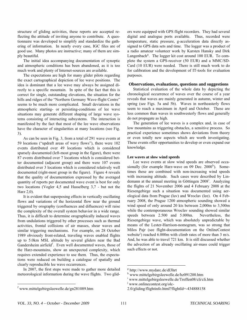
Introduction The orography of northern Germany is characterized by extended plains. This landscape shows negligible differences in heights, smoothly formed by the glaciers and rivers of the Quaternary. Southwards, lower mountains dominate the scene. The valleys and heights developed as layers of trias, which form the surface of the northern lee wave region, were folded during later geological periods. This genesis generated many more ridges than single peaks. The ridges reach heights from about 300m to 400m MSL i.e. around 100m to 200m – or less – relative to the valley floors. Only a few elevations rise up to more extended heights: the Harz Mountains generally around 600m (“Clausthaler Hochfläche”), culminating in the Brocken Massive at 1.140m, the Hohe Meissner at 750m, the Thüringer Wald at 980m, the Rhön at 930m, the Fichtelgebirge at 1.050m and the Erzgebirge at 1.200m (see Fig. 1). The ridgelines in the region northwest of the Harz Moun-tains (called the Weser- and Leine-Bergland) are mostly aligned from southeast to northwest – due to a specific tectonic load. This washboard-like orography is especially suitable for generating lee waves. In 1961, Walter Georgii aptly titled this region the “Northern Germany Wave-flight Centre” (see Fig. 2). These orographic conditions and the ability of ample, rap-idly moving, suitably stratified airmasses not only allow the triggering of lee waves and their vertical and/or horizontal propagation, but they enable resonant reenforcement of atmos-pherical wave trains by the ridges and valleys situated “in phase” with the wavy flow. It is mainly southwesterly and northeasterly weather situations which lead to the occurrence of lee waves. In northern Germany, soaring sports are dominated by clubs, even though nowadays more and more private owners are becoming involved. Nevertheless, it is predominantly a non-commercial infrastructure. With volunteers helping to cut costs, wave flying in the lower mountains has turned into a
popular aeronautic sport. Glider pilots come from all walks of life; their qualifications and motivations reflect this variety. Aiming at a historical backdrop, some reports on out-standing aeronautical achievements resulting from the de-scribed environment up to now can be given. For example, in the 1960’s some pilots reached altitudes around 5000m MSL in resonant waves of the Hasselberg-Süntel-Deister system, hilly ridges with heights of 300m MSL situated a few kilome-ters south of Hannover. In 1968, W. Reinhard flew to the re-cord altitude of 7800m MSL in the lee of this resonant wave system using a Scheibe “Zugvogel”a. Excited glider pilots generated a lee-wave hype at that time. But, further spreading of the activities suffered because in the midst of the wave area there was a political frontier dividing Germany – with a broad “Air Defense and Identification Zone”, which made wave flights impossible. And, club gliders for the most part were built of wood and fabric so that they needed extended mainte-nance by the clubs during autumn and winter when the waves develop best. At this time, Carsten Lindemann began to investigate the lee waves of this region1, just as Erland Lorenzen did for the region of Thüringer Wald, Erz- and Riesengebirge. Attempts to build a wave forecast generally available for glider pilots, to organize and document wave flights were severely hampered by expensive and slow communication methods. That is why these early activities faltered.
The “Mittelgebirgswellen” - project in general Towards the end of the 1980’s, all of these conditions had changed: a united German state existed; new materials for gliders were available; information exchange by e-mail was fast and cheap and the Internet provided an easily accessible platform for the publication of data. During the mid-nineties, www.mittelgebirgsleewelle.de (website in German language,
awww.mittelgebirgsleewelle.de/wredei.htm
VOL. 33, NO. 4 – October - December 2009 TECHNICAL SOARING 109
only) developed into a forum for lee wave information docu-mentation and information exchange for glider pilots and for scientists. The aim was (and is) to provide glider pilots with information on where they could fly waves, under which circumstances and to gather information as parts of a puzzle for a lee wave climatology of the lower mountains in Germany. All of this remained on a strictly volunteer basis.
The most important contribution to the success of this ini-tiative was the lee wave forecast by Erland Lorenzen, a free publication written for the single purpose of lower mountain wave flying. The information is distributed to more than 400 recipients by e-mail as a seven-days-a-week volunteer service by Wolfgang Lieder a member of Aschersleben/Harz gliding-club. For self-briefing purposes for pilots, the national weather service Deutscher Wetterdienst (DWD) provides specific in-formation in form of PC_Metb, which is not available free of charge. Beside the standard portfolio of tools for synoptic forecasts, there are specifics as atmospheric soundings, pre-dicted weather model soundings and the Scorer-parameter with altitude for diverse-locations of the wave area. The new mod-els of the DWD are providing wave forecasts by mapping the model-calculated spatial distribution of patterns of vertical motion of airmasses, clearly showing lee wave up- and down-draft areas. SkyView is a visualization-tool for parameter-fields originating from the COSMO-LM (COnsortium for Small-Scale Modelling) with a horizontal mesh width (∆x) of 7 km. COSMO-DE with ∆x 2,8 km is dedicated to visualize the meso-γ-scale3, using also RADAR- and satellite-datasets for initialization. Both models are non-hydrostatic. The wavy flow of an air mass is clearly depicted. Several comparative studies of the forecasts and satellite photos of lee waves dem-onstrate that the forecasts are working reliably.2 Nevertheless, the documentation of wave observations and flight reports is needed to help plan flights. Up to now, more than 500 wave reports have been published. The reports are sent to the author at Bad Gandersheim glider-club/Leinebergland. He, then, passes them on to the same pool of recipients as the Lorenzen forecast is distributed to. The information also is permanently, and in more detail, published at www.mittelgebirgsleewelle.de. Outstanding events are the first flights made by Jürgen Dittmar initially using the smooth waves of the hilly environ-ment of the Klix airfeld (near Dresden) towards the strong waves of the Riesengebirge. He set out on this unimaginable adventure motivated only by theory and visions by Karl-Heinz Dannhauer, Leipzig-Oschatz gliding-club, in the www.mittelgebirgsleewelle.de information exchangec. Also worth highlighting is a flight to 7200m MSL in the lee of the Harz mountains by Carsten Lindemann and Walter Doppel-
bwww.flugwetter.de cwww.mittelgebirgsleewelle.de/treffen04/khda/khda04.htm
steind, and a 300km FAI-triangle (started in Hofgeismar near Kassel) by Wolfgang Stoepel flown only in waves above cu-mulus cloudse. Since 2000, meetings of the www.mittelgebirgsleewelle.de community have taken place once a year at different locations and every second year as guest of the Deutsches Zentrum für Luft- und Raumfahrt e.V. (DLR) in Göttingen. Glider pilots report on their experiences and also lectures are given by me-teorologists (for example, René Heise, Carsten Lindemann, Erland Lorenzen and Hermann Trimmel). The group estab-lished contact with Dieter Etling of the Leibniz-University Hannover who contributed regularly. Also, regularly, articles were published by aeronautic sports magazines reporting on the meetings and outstanding wave flights. The entire organi-zation is a decentralized, self-organized network of contribu-tors with the website and its operator as persisting crystalliza-tion point.
Methods, aims and obstacles Most of the activities are directly or indirectly determined by the character and circumstances of practical flying – a reminisence of the discovery and early exploration of the lee wave phenomenon by Joachim Kuettner, who initiated the first scientific wave exploration with gliders at the Riesengebirge-mountains in 19373. The number and distribution of wave flight reports depends on the intensity of gliding activities in different areas and alti-tudes. The neighbourhood of airfields is a preferred location for lee wave flights due to the higher density of flight activities just as are ridge running routes. Areas with restricted airspace will not be locations of intense wave flying. For example, the lack of wave flights in the Süntel-Deister system is due to re-stricted airspace in the neighbourhood of the Hannover-Langenhagen airport, while the SW waves of the unrestricted Hasselberg area is frequent used because of its situation near the SW ridge lift of the Wesergebirge. Flights exceeding alti-tudes of 10.000ft MSL are rare because of the necessity of air traffic clearances. Areas with temporary clearances for high-altitude flights are NE of the Harz-Mountains, the Hoher Meissner and the Thüringer Wald. These regions have raised the number of wave flights exceeding 3.0km MSL. There also will be some local self-reinforcement between reporting and flying because of the intense public relation activities concern-ing wave flying practiced at some airfields. Continuity of reporting within the gliding community of northern Germany is not only driven by sophisticated interest but also by the need of the pilots to share their flight adven-tures with others. This social component played an important role during the implementation of the activities. That is why the reports show quite different stages of elaboration, depending on the individual intensity of interest and the capabilities of each reporter. In the club-dominated
d www.mittelgebirgsleewelle.de/hz301000.htm e www.mittelgebirgsleewelle.de/ul160400.htm
TECHNICAL SOARING VOL. 33, NO. 4 – October - December 2009 110
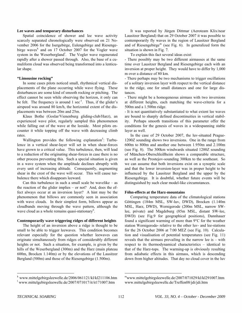
structure of gliding activities, these reports are accepted re-flecting the attitude of inviting anyone to contribute. A ques-tionnaire was developed to simplify and standardize the gath-ering of information. In nearly every case, IGC files are of good use. Many photos are instructive; many of them are sim-ply beautiful. The initial idea accompanying documentation of synoptic and atmospheric conditions has been abandoned, as it is too much work and plenty of Internet-sources are available. The expectations are high for many glider pilots regarding the exact cartographical depiction of lee wave positions. The idea is dominant that a lee wave may always be assigned di-rectly to a specific mountain. In spite of the fact that this is correct for single, outstanding elevations, the situation for the hills and ridges of the “Northern Germany Wave-flight Centre” seems to be much more complicated. Small deviations in the atmospheric starting- or persisting-conditions of lee wave situations may generate different shaping of large wave sys-tems consisting of interacting subsystems. The interaction is manifested by the fact that most of the lee wave observations have the character of singularities at many locations (see Fig. 3). As can be seen in Fig. 3, from a total of 291 wave events at 59 locations (“updraft areas of wavy flows”), there were 102 events distributed over 49 locations which is considered sparsely documented (left-most group in the figure), there were 87 events distributed over 7 locations which is considered bet-ter documented (adjacent group) and there were 107 events distributed over 3 locations which is considered relatively well documented (right-most group in the figure). Figure 4 reveals that the quality of documentation expressed by the averaged quantity of reports per documented wave event is best for only two locations (Vogler 4,5 and Hasselberg 3,7 - but not the Harz 2,0). It is evident that superposing effects in vertically oscillating flows and variations of the horizontal flow near the ground triggered by orography (confluences and difluences) will raise the complexity of the overall system behavior in a wide range. Thus, it is difficult to determine orographically induced waves from undulations triggered by other processes such as thermal activities, frontal collisions of air masses, shear waves and similar triggering mechanisms. For example, on 28 October 1989 obviously front-related, traveling waves enabled flights up to 5.0km MSL altitude by several gliders near the Bad Gandersheim airfieldf. Even well documented waves, those of the Harz-mountains, show an unexpected complexity, which requires extended experience to use them. Thus, the expecta-tions were reduced on building a catalogue of spatially and clearly reproducible lee wave occurrences. In 2007, the first steps were made to gather more detailed meteorological information during the wave flights. Two glid-
f www.mittelgebirgsleewelle.de/gn281089.htm
ers were equipped with GPS flight recorders. They had several digital and analogue ports available. Thus, recorded were temperature, static pressure, g-acceleration data directly as-signed to GPS data sets and time. The logger was a product of a radio amateur volunteer work by Karsten Hansky and Dirk Langenbachg. The logger kit cost around 100 EUR. To com-plete the system a GPS-receiver (50 EUR) and a MMC/SD-Card (10 EUR) were needed. There is still much work to do for calibration and the development of IT-tools for evaluation purposes. Observations, evaluations, questions and suggestions
Statistical evaluation of the whole data by depicting the chronological occurrence of waves over the course of a year reveals that waves are mainly generated in autumn, winter and spring (see Figs. 5a and 5b). Waves in northeasterly flows seem to reach a maximum in April and October. These are less common than waves in southwesterly flows and generally do not propagate as high. The generation of lee waves is a complex and, in case of low mountains as triggering obstacles, a sensitive process. So practical experience sometimes shows deviations from theory or even totally new aspects which are worth investigating. These events offer opportunities to develop or even expand our knowledge. Lee waves at slow wind speeds Lee wave events at slow wind speeds are observed occa-sionally (for example Harz-wave on 09 Dec. 2000h). Some-times these are combined with non-increasing wind speeds with increasing altitude. Such cases were described by Lin-demann at the annual meeting in Göttingen 2008i. Analyzing the flights of 21 November 2006 and 4 February 2008 at the Riesengebirge such a situation was documented using aer-ological data from Prague (luv) and Wroclav (lee). On 4 Feb-ruary 2008, the Prague 1200 atmospheric sounding showed a wind speed of only around 20 kts between 2,000m to 3,500m while the contemporaneous Wroclav sounding showed similar speeds between 2.500 and 5.000m. Nevertheless, the Riesengebirge wave, which was absolutely unpredictable by means of the Lester-Harrison-nomogram, was so strong that Milos Pajr (see flight-documentation on the OnlineContest websitej) reached 6.000m with climb rates of more than 3 m/s. And, he was able to travel 721 km. It is still discussed whether the advection of an already oscillating air-mass could trigger such effects or not.
g http://www.mydarc.de/dl3hrt h www.mittelgebirgsleewelle.de/hz091200.htm i www.mittelgebirgsleewelle.de/Treffen08/cli/cli.htm j www.onlinecontest.org/olc-2.0/gliding/flightinfo.html?flightId=-434888158
VOL. 33, NO. 4 – October - December 2009 TECHNICAL SOARING 111
Lee waves and temporary disturbances Spatial coincidence of shower and lee wave activity scarcely separated chronologically were observed on 21 No-vember 2006 for the Isergebirge, Eulengebirge and Riesenge-birge wavesk and on 17 October 2007 for the Vogler wave system in the Weserberglandl. The Vogler wave regenerated rapidly after a shower passed through. Also, the base of a cu-muliform cloud was observed being transformed into a lenticu-lar shape.
“Limousine rocking” In some cases pilots noticed small, rhythmical vertical dis-placements of the plane occurring while wave flying. These disturbances are some kind of smooth rocking or pitching. The effect cannot be seen while observing the horizon, it only can be felt. The frequency is around 1 sec-1. Thus, if the glider’s airspeed was around 80 km/h, the horizontal extent of the dis-placements was between 20m and 25m. Klaus Bothe (Goslar/Vienenburg gliding-club/Harz), an experienced wave pilot, regularly sampled this phenomenon while falling out of the wave at the leeside. Most pilots en-counter it while topping off the wave with decreasing climb rates. Wallington provides the following explanation5: Turbu-lence in a vertical shear-layer will set in when shear-forces have grown to a critical value. This turbulence, then, will lead to a reduction of the originating shear-forces in case there is no other process preventing this. Such a special situation is given in a wave system when the amplitude declines abruptly with every unit of increasing altitude. Consequently, augmenting shear in the crest of the wave will occur. This will cause tur-bulence there which disappears leeward. Can this turbulence in such a small scale be wavelike – as the reaction of the glider implies – or not? And, does the ef-fect always occur at an inversion layer? A hint may be the phenomenon that billows are commonly seen in association with wave clouds. In their simplest form, billows appear as cloudbands moving through the wave pattern, although the wave cloud as a whole remains quasi-stationary6. Contemporarily wave triggering ridges of different heights The height of an inversion above a ridge is thought to be small to be able to trigger leewaves. This condition becomes relevant especially for the question whether leewaves can originate simultaneously from ridges of considerably different heights or not. Such a situation, for example, is given by the hills of the Weserbergland (300m) and the Harz (main plateau 600m, Brocken 1.140m) or by the elevations of the Lausitzer Bergland (500m) and those of the Riesengebirge (1.500m).
k www.mittelgebirgsleewelle.de/2006/061121/kl/kl211106.htm l www.mittelgebirgsleewelle.de/2007/071017/it/it171007.htm
It was reported by Jürgen Dittmar (Aeroteam Klix/near Lausitzer Bergland) that on 29 October 2007 it was possible to contemporarily fly waves in the region of Lausitzer Bergland and of Riesengebirgem (see Fig. 6). In generalized form the situation is shown in Fig. 7. To explain this fact several ideas exist: - There possibly may be two different airmasses at the same time over Lausitzer Bergland and Riesengebirge each with an inversion at proper height. They would have to differ by 1,000 m over a distance of 80 km. - There perhaps may be two mechanisms to trigger oscillations of a solitary inversion layer with respect to the vertical distance to the ridge, one for small distances and one for large dis-tances. - There might be a homogeneous airmass with two inversions at different heights, each matching the wave-criteria for a 500m and a 1.500m ridge. - It is not quantitatively substantiated to what extent lee waves are bound to sharply defined discontinuities in vertical stabil-ity. Perhaps smooth transitions of this parameter offer the conditions for the genesis of waves in a widespanning stable layer as well. In the case of 29 October 2007, the luv-situated Prague-1200Z sounding shows two inversions. One in the range from 600m to 800m and another one between 1.950m and 2.100m (see Fig. 8). The 300km windwards situated 1200Z sounding of München-Oberschleißheim shows a comparable structure, as well as the Prostejov-sounding 300km to the southeast. So we can assume that both inversions exist on a synoptic scale and that the lower inversion-layer was in proper height to be influenced by the Lausitzer Bergland and the upper by the Riesengebirge. It is doubtful, whether future events will be distinguished by such clear model-like circumstances. Föhn-effects at the Harz-mountains Comparing temperature data of the climatological stations Göttingen (184m MSL, SW-luv, DWD), Brocken (1.140m MSL, Harz, DWD), Wernigerode (200m MSL, narrow SW-lee, private) and Magdeburg (85m MSL, distant SW-lee, DWD) (see Fig.9 for geographical positions), Dannhauer found a significant warming of more than 9°C for the weather station Wernigerode- relative to the other luv- and lee-stations for the 26 October 2006 at 7:00 MEZ (see Fig. 10). Calcula-tion and visualisation of potential temperatures (see Fig. 11) reveals that the airmass prevailing in the narrow lee is – with respect to its thermodynamical characteristics – identical to that of the Harz-tops. The warming-up is obviously resulting from adiabatic effects in this airmass, which is descending down from higher altitudes. That day no cloud cover in the luv
mwww.mittelgebirgsleewelle.de/2007/071029/kl/kl291007.htm www.mittelgebirgsleewelle.de/Treffen08/jdi/jdi.htm
TECHNICAL SOARING VOL. 33, NO. 4 – October - December 2009 112
nor precipitation upwind (“Steigungsregen”) were observed, only dry adiabatic processes ruled the scene. The presumption of a foehn-effect being the reason for this is supported by the fact that static pressure at this time reached a minimum value at Wernigerode (see Fig. 12), while wind speed shows an inverted development at the Brocken-station (see Fig. 13).
Future projects There is already a considerable backlog of data-sets await-ing processing and evaluation, collected from numerous well-documented flights in the Hasselberg- and Vogler waves. It is intended to conduct a more elaborated comparison of prevail-ing flight characteristics with observed meteorological condi-tions. Beyond that, it is planned to retrieve information about the height, intensity and thickness of stable layers which allow the generation of gravity-waves by means of GPS data-loggers. In the context of endeavors to find out the lateral extension of foehn-effects of the Harz mountains, an attempt will be made to link the GPS measurements with data from terrestrial meteorological stations. The first steps preparing collaboration with a committed radio amateur group may provide the techni-cal equipment for measuring and telecommunication purposes. The use of thermal waves by glider-pilots seems to be un-derrepresented compared to the number of obviously existing chances provided by suitable meteorological conditions. There is a need to start some kind of information campaign referring to thermal waves and the understanding of the phenomenon. Also, it is amazing to observe wide-ranging, stationary wave-systems visible in time-lapse photography taken by satel-lites imprinted in the scattered distribution of cumulus clouds. The author is eager to explore whether these wide-spreading structures originate from shear or topographic effects and are superposing thermal activitiy or whether convection itself is the ‘motor’ of the apparent self-organizing processes. These wave systems are a thrilling observation and an ambitious plan with strong references to practical flying purposes will be re-quired to learn more about the causes of this phenomenon. Starting in 2008, the verification or falsification of wave-forecasts provided by a computer model built up by John Glendeningn and implemented by Hendrik Hoeth for the north-ern Germany regiono is planned. All these activities are accompanied by a steady interest to document historical aspects of wave-flying in northern Ger-many and to attempt to document the evolution of ideas, hy-potheses and theories in science related to the topic of atmos-pheric waves. To spare some time for all this, it is intended to implement a content-management-system for the “Mittelgebirgswellen”
n www.drjack.info o rasp.linta.de/NIEDERSACHSEN_WAVE
website, which will allow an upload of observation- and flight-reports by the pilots themselves.
Concluding remarks Gliding has always been primarily the experience of nature. This statement is even valid for aeronautical activities which seem to be dominated purely by sport competition. In many cases, gliding has triggered and influenced especially meteoro-logical research, and in this way has been a link between a vivid encountering of natural phenomena and explanatory sci-ence. In this context, the contribution of this paper to science is to make known the possibilities for acquiring data with the described gliding-initiative. But, this report, as illustrated in the “Observations, evalua-tions, questions and suggestions” section, places a demand on science to clear up the backlog of required specific knowledge. For many years, science has not been producing knowledge in a form suitable for understanding by those who could profit while handling the phenomena practically. It seems that OS-TIV, as far as its constituting aims are concerned, may play an outstanding role in this desirable process.
References 1Lindemann, C., "Leewellen in der Flugmeteorologie“, Meteorolo-
gische Abhandlungen, Band 89 / Heft 4, Institut für Meteorologie der Freien Universität Berlin / Verlag Von Dietrich Reimer, Berlin, 1971 (Diplomarbeit, vorgelegt im Mai 1970).
2Thehos, R., “Wo steht die lange Welle?“, Aerokurier, 2/2007. 3Dörnbrack, A., Heise, R., Kuettner, J.P., "Wellen und Rotoren",
promet 32, Heft 1/2, Deutscher Wetterdienst, Offenbach, 2006, p. 22 (www.pa.op.dlr.de/trex/publications/doernbrack-etal-promet_Heft1-2_2006.pdf).
4WMO (World Meteorological Organisation), “Weather forecasting for soaring flight”, Geneva, Technical Note No.208, 2009, p. 3-5.
5Wallington, C.E., “Meteorologie für Segelflieger”, Sonderausgabe der Luftsportjugend des Deutschen Aero Club e.V., Wilhelm Limpert Verlag GmbH, Frankfurt/M., 1967, p. 230 (also “Meteorology for glider pilots“, 3rd Edition, 1977, J. Murray, London).
6WMO, “The airflow over mountains”, Geneva, Technical Note No.34, 1960, p. 10.
VOL. 33, NO. 4 – October - December 2009 TECHNICAL SOARING 113
Figure 1 Wave area of the lower mountains of northern Germany (the heartland is marked by a frame and detailed in Fig. 2). [Source of map: www.mygeo.info/landkarten_deutschland.html under GNU Free Documentation License]
Figure 3 The quality of documentation at locations depends on the quantity of documented wave events in the area defined in Figs. 1 and 2. Many documented wave events occurred at only single locations; for example, 50 events at the Harz. In contrast, only one documented wave event occurred at many locations; for example 27 locations.
Figure 2 “Northern Germany Wave-flight Centre”. Marked are the frequent SW waves of the Harz- (3) and the Vogler-Mountains (2), as well as those of the famous Hasselberg-Süntel-Deister system (1) and the W-and E-waves of the Hoher Meißner (4). [Source of map: www.mygeo.info/landkarten_deutschland.html under GNU Free Documenta-tion License]
TECHNICAL SOARING VOL. 33, NO. 4 – October - December 2009 114
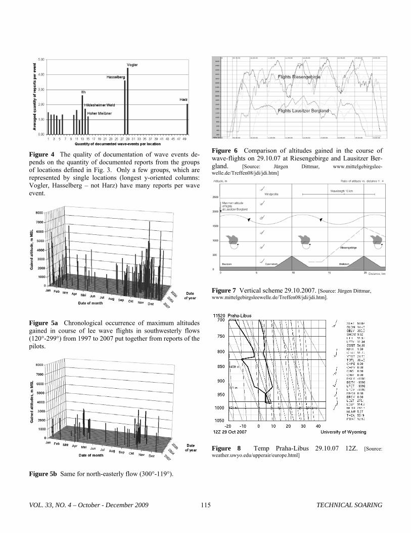
Figure 4 The quality of documentation of wave events de-pends on the quantity of documented reports from the groups of locations defined in Fig. 3. Only a few groups, which are represented by single locations (longest y-oriented columns: Vogler, Hasselberg – not Harz) have many reports per wave event.
Figure 5a Chronological occurrence of maximum altitudes gained in course of lee wave flights in southwesterly flows (120°-299°) from 1997 to 2007 put together from reports of the pilots.
Figure 5b Same for north-easterly flow (300°-119°).
Figure 6 Comparison of altitudes gained in the course of wave-flights on 29.10.07 at Riesengebirge and Lausitzer Ber-gland. [Source: Jürgen Dittmar, www.mittelgebirgslee-welle.de/Treffen08/jdi/jdi.htm]
Figure 7 Vertical scheme 29.10.2007. [Source: Jürgen Dittmar, www.mittelgebirgsleewelle.de/Treffen08/jdi/jdi.htm].
Figure 8 Temp Praha-Libus 29.10.07 12Z. [Source: weather.uwyo.edu/upperair/europe.html]
VOL. 33, NO. 4 – October - December 2009 TECHNICAL SOARING 115
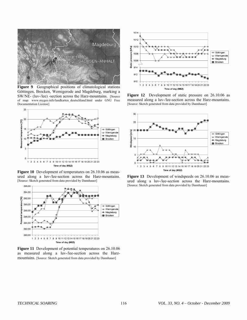
Figure 9 Geographical positions of climatological stations Göttingen, Brocken, Wernigerode and Magdeburg, marking a SW/NE- (luv-/lee) -section across the Harz-mountains. [Source of map: www.mygeo.info/landkarten_deutschland.html under GNU Free Documentation License]
Figure 12 Development of static pressure on 26.10.06 as measured along a luv-/lee-section across the Harz-mountains. [Source: Sketch generated from data provided by Dannhauer]
Figure 10 Development of temperatures on 26.10.06 as meas-
ured along a luv-/lee-section across the Harz-mountains. [Source: Sketch generated from data provided by Dannhauer]
Figure 13 Development of windspeeds on 26.10.06 as meas-ured along a luv-/lee-section across the Harz-mountains. [Source: Sketch generated from data provided by Dannhauer]
Figure 11 Development of potential temperatures on 26.10.06 as measured along a luv-/lee-section across the Harz-mountains. [Source: Sketch generated from data provided by Dannhauer]
TECHNICAL SOARING VOL. 33, NO. 4 – October - December 2009 116