Embed Size (px)
Citation preview
� � � � � � � � � � V� � � � � � �� I n � � I � � I � � � � � � I O� � Vi OI VN � VTo�
A Proposal to the IDC Committee �
Submitted by
Kathleen Affholter Associate Professor, Earth Science Natural and Behavioral Sciences
March, 2013
Approved by: ____________________________
_________________________________________
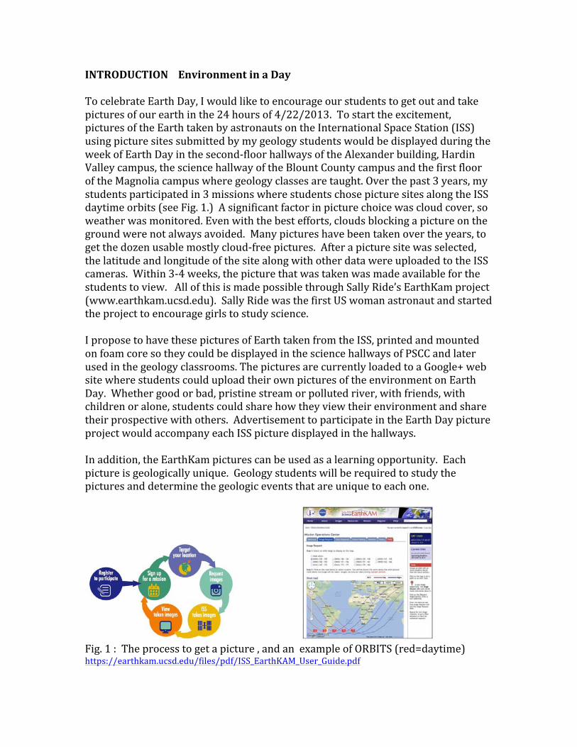
INTRODUCTION Environment in a Day To celebrate Earth Day, I would like to encourage our students to get out and take pictures of our earth in the 24 hours of 4/22/2013. To start the excitement, pictures of the Earth taken by astronauts on the International Space Station (ISS) using picture sites submitted by my geology students would be displayed during the week of Earth Day in the second-‐floor hallways of the Alexander building, Hardin Valley campus, the science hallway of the Blount County campus and the first floor of the Magnolia campus where geology classes are taught. Over the past 3 years, my students participated in 3 missions where students chose picture sites along the ISS daytime orbits (see Fig. 1.) A significant factor in picture choice was cloud cover, so weather was monitored. Even with the best efforts, clouds blocking a picture on the ground were not always avoided. Many pictures have been taken over the years, to get the dozen usable mostly cloud-‐free pictures. After a picture site was selected, the latitude and longitude of the site along with other data were uploaded to the ISS cameras. Within 3-‐4 weeks, the picture that was taken was made available for the students to view. All of this is made possible through Sally Ride’s EarthKam project (www.earthkam.ucsd.edu). Sally Ride was the first US woman astronaut and started the project to encourage girls to study science. I propose to have these pictures of Earth taken from the ISS, printed and mounted on foam core so they could be displayed in the science hallways of PSCC and later used in the geology classrooms. The pictures are currently loaded to a Google+ web site where students could upload their own pictures of the environment on Earth Day. Whether good or bad, pristine stream or polluted river, with friends, with children or alone, students could share how they view their environment and share their prospective with others. Advertisement to participate in the Earth Day picture project would accompany each ISS picture displayed in the hallways. In addition, the EarthKam pictures can be used as a learning opportunity. Each picture is geologically unique. Geology students will be required to study the pictures and determine the geologic events that are unique to each one.
Fig. 1 : The process to get a picture , and an example of ORBITS (red=daytime) https://earthkam.ucsd.edu/files/pdf/ISS_EarthKAM_User_Guide.pdf
� � � � � � � � � �
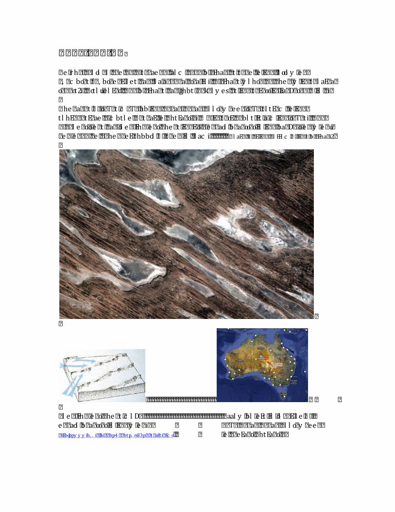
� e r h� � � � l ol � I � � � e � � � � � t � � ae � � � � al c � � � � � � b � Eha� � � t � t � � e � e � E� � � � l ool y e � �� , � c bo� t � f � , bo� e � E l et � � a� � � l a� a� � � � a� � o� a EI i� � � � Eha� t � y l ho� � � � � � he � � y E� � t � l aE� a�o� � � ot2i� � � ot l u� el E� d� � � � � � b � Eha� t � � a� � ghbt � � k� l y es� � t � E� � � t � E� oo E� � Ea� D� o� � � � � El � � i�� he � a� � t � l � � o� T� t � c � T� � hb� E� � � � � � a� � � � � a� � � l l o� y � ee � � o� T� � t I tE� c � e � E� � �t l hE� � � tE� ae � � c btl e � � � t � aE� e � � htEa� o � i� � � E� � t � oE� � � bl t Et � a c � E� � � o� T� t i� � � � � �� � � l e � o� o e � t � � a� � ol e � Eh� e � o� � he � t � E� � E� o � � e � � aoI � b� a� oo� o� El � E� � � ba� D� o e � � y e � u�� e � � e � � � � � e � � � he � � eE� thbboI � l � � t � e � � El � � l ac i� � � � � � � � � � f � l aE� � t � � E� E� � � � l EEl c � l � � E� t � b � Eha� i2��
��
� � � � � � � � � � � � � � � � � � � � � � � � � � � � � � � � � � � � � � � � � � � ��� l e � Eh� e � o� � he � t � c l D� � � � � � � � � � � � � � � � � � � � � � � � � � � � � � � � � � � � � � � � � � � � � � � � � aal y � bl eEt � El � ol � � E l e � l � � �e � � aoI � b� a� oo� o� El � E� � � y e � i� � � � � � T� � � � � a� � � � � a� � � l l o� y � ee � �� EEbdppy y y ih, . i� hi� � hp4 � � btp. m33p� � t � aEti� Ec o� � � e � � � eEa� o� � htEa� o � �
� � � � � � � � � � � � � � � � � � � � � � � � � � � � � � � � � � � � � � � � �
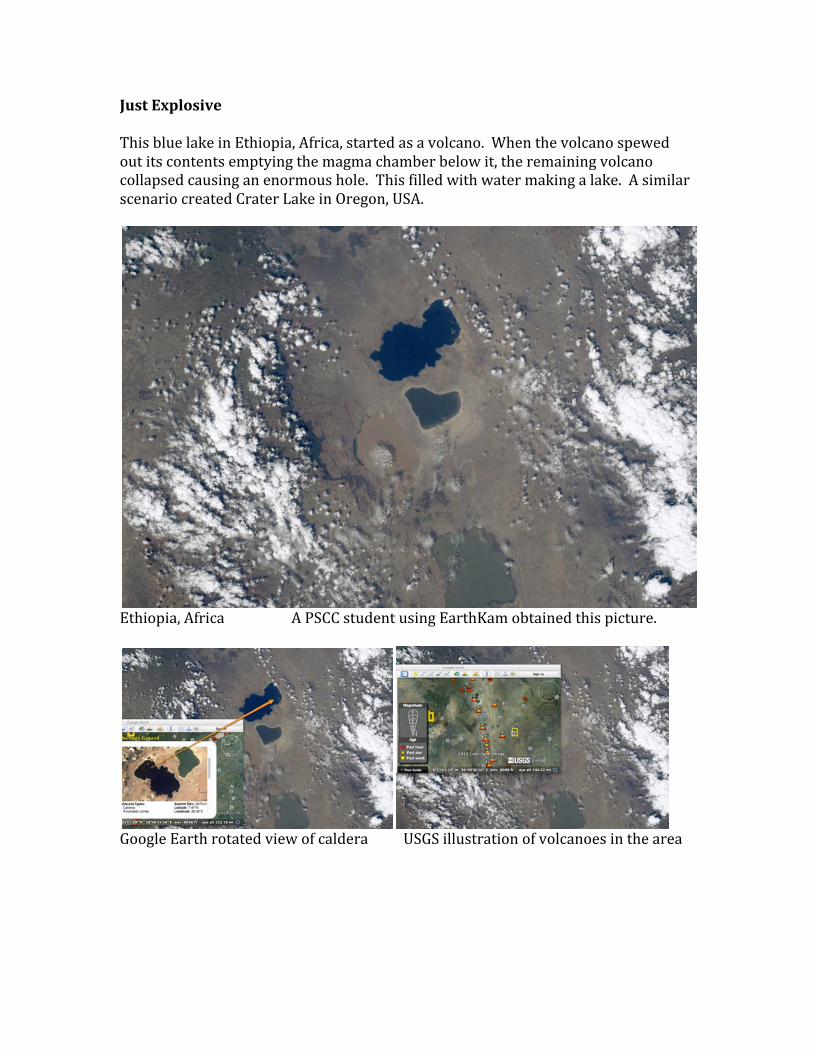
Just Explosive This blue lake in Ethiopia, Africa, started as a volcano. When the volcano spewed out its contents emptying the magma chamber below it, the remaining volcano collapsed causing an enormous hole. This filled with water making a lake. A similar scenario created Crater Lake in Oregon, USA.
Ethiopia, Africa A PSCC student using EarthKam obtained this picture.
Google Earth rotated view of caldera USGS illustration of volcanoes in the area
Not all mountains are the same. The Andes Mountains in South America are made of volcanoes, the result of an oceanic and a continental tectonic plate collision.
Andes Mountains A PSCC student using EarthKam obtained this picture. People that live near the Andes Mountains experience earthquakes that are associated with the mountain-‐building activity. A magnitude 8.8 earthquake in 2010, off the coast of Chile, caused 535 deaths and from 4 to 7 billion dollars of damage.
An oceanic-‐continental tectonic plate collision creates volcanic mountains like those in Chile (USGS illustration).
The Himalaya Mountains are rising as rocks smash into each other, fold, and stack on top of one another along great breaks in the rocks. The folding and faulting in this part of the world, the border of India, Bhutan, Nepal, and Pakistan with China, is the result of two continental tectonic plates colliding. The Himalayas are not made by the action of igneous volcanoes, as are the Andes Mountains. The Himalayas are mostly sedimentary and metamorphic rocks. Despite their austere beauty, like the Andes, these mountains harbor dangers, too. A large earthquake in 2008 associated with mountain building killed 69,000 people in China.
Himalaya Mountains A PSCC student using EarthKam obtained this picture.
Two continental plates colliding create mountains like the Himalayas (USGS illustration)
� O� � I M� � � T� O�
� T� � E� � � � � ee � t t � � � � D� au� E� � � a D� au� e � E� � � � l EEl c � � � o� � l � � E� t � b � Eha� � � al c � � l aE� � ae �� htEa� o � u� c � � e � � at � � � al tt � � � � ol l � � bo� e � � e � � o� � D� t � � l at � t � l � kt � � b� � � a� c e � eEt � l � �E� � � c � � e � � at � ba� D l ht � bl t E l etu� � � oo� � � l , � l y � o� T� t i� � � t � y � E� a� c l D� t � tol y oI �� al he � � E� � � et � � � l � � � � � � � � haD� � � e � � r h � ToI � � al he � � E� � � l hE� a� � � e � � l � � � � � � � � haD� � e �E� � � a D� au� t � � c � eE� t � � � bl t E� � � l e � bl eE� � � at � fy � E� 2� l e � E� � � et � � u� � e � � a� c l D� � �� al c � E� � � � hE� � � eTt � l e � E� � � l hEt � � � l � � � � � � � � � e � i� � e � E� � � � l EEl c � a � � E� l � � E� � � b� l El u� E� � �a D� a� E� T� t � l e � � a� � � � � � � � a� � E� a tE � t i�
� � e � � a e � � tEa� � c � e � � htEa� o � u� b� l El � E� T� e � � I � � � � � � � � � tEh� � eE� ht e � � �� aE� � � c �
�� l ac � E l e � l � � l , � l y � o� T� t � l D� a� E c � �� EEbdppy y y i� � l oihc � i� � hp4 c � a� Tp� � l o. 33p c � � � tpm3pol l bxi� � �
Underground water sources are being tapped to supply Libya with water. Ironically, water is being pumped from the desert to the coast because it is cheaper than desalinization of ocean water. Although Libya's primary agricultural water source is the Great Man Made Water (GMMR), research is being done on desalinization since the aquifer being tapped is expected to last between 60 and 1000 years.
Agriculture (black circles) in Libya, photo taken by a PSTCC instructor using EarthKam. Land color is actually golden yellow.
Image from Google Earth of watering technique photo location in red
Materials Photos have already been taken from the International Space Station in 2011, 2012, and the spring of 2013 by PSTCC students of geology participating in Sally Ride’s EarthKam program. The pictures have been checked at a photo store web site to see if they can be blown up to the desired size and preserve quality. A Google + web site has been generated for the ISS EarthKam pictures. Students would submit environmental pictures for the Environment in a Day celebration to the Google+ website. Using Google+ is free, but students would have to create a gmail account if they don’t have one to gain access to Google+. Student submitted pictures will be checked on the website to avoid spam or improper material. Other materials needed would be printing and material to mount the photographs on foam core (see Table 1), picture hanging supplies (preferably removable hanging material), and smaller photographs for classroom use (see Table 2.) The NBS department would provide the lamination materials for the smallest pictures, all picture labels and explanations, and invitations to participate in the EarthDay photograph project that would accompany the pictures. Assessment Short-term, the Google+ website would be monitored for Earth Day participation in the “Environment in a day” photo project. Long term, geology students would be expected to study three of the Earth pictures and interpret the geology of each one using Google Earth, their textbook, the world wide web and research papers as aides in a similar, but more in depth way to what has been done above. A written report on the pictures would be turned in at the end of the semester.

Budget. Table 1 Photos mounted to display at 3 campuses. EarthKam Color Photos
Size (feet)
Cost of print
Mount Material
No. Cost
Foam core Andes Mountains, S.A. 2 X 3 $62.99 $45.00 1 $107.99 Ethiopia caldera, Africa 2 X 3 $62.99 $45.00 1 $107.99 Himalayas, Asia 2 X 3 $62.99 $45.00 1 $107.99 Australia meander 2 X 3 $62.99 $45.00 1 $107.99 Australia salt lakes 2 X 3 $62.99 $45.00 1 $107.99 Australia ocean 2 X 3 $62.99 $45.00 1 $107.99 Australia folds 2 X 3 $62.99 $45.00 1 $107.99 Australia clouds 2 X 3 $62.99 $45.00 1 $107.99 Libya agriculture 2 X 3 $62.99 $45.00 1 $107.99 Clouds in Atlantic 2 X 3 $62.99 $45.00 1 $107.99 Appalachian Mtns., U.S.A. 2 X 3 $62.99 $45.00 1 $107.99 Hawaii, U.S.A. 2 X 3 $62.99 $45.00 1 $107.99 Tax @ 9.25% $119.87 Total $1415.76 Table 2 For use in the classroom at three campuses. EarthKam Color Photos
Size Lamination Photo Cost
No. Cost
Andes Mountains, S.A. 5 X 7 NBS lamination $2.47 3 $7.41 Ethiopia caldera, Africa 5 X 7 NBS lamination $2.47 3 $7.41 Himalayas, Asia 5 X 7 NBS lamination $2.47 3 $7.41 Australia meander 5 X 7 NBS lamination $2.47 3 $7.41 Australia salt lakes 5 X 7 NBS lamination $2.47 3 $7.41 Australia ocean 5 X 7 NBS lamination $2.47 3 $7.41 Australia folds 5 X 7 NBS lamination $2.47 3 $7.41 Australia clouds 5 X 7 NBS lamination $2.47 3 $7.41 Libya agriculture 5 X 7 NBS lamination $2.47 3 $7.41 Clouds in Atlantic 5 X 7 NBS lamination $2.47 3 $7.41 Appalachian Mtns., U.S.A.
5 X 7 NBS lamination $2.47 3 $7.41
Hawaii, U.S.A. 5 X 7 NBS lamination $2.47 3 $7.41 Tax @ 9.25% $8.23 Total $97.15 Wall hanging materials for 2X3’ photos
$30.00
Grand Total (Table 1, Table 2, wall hanging materials) $1542.91
The next EarthKam mission is in April. Where would YOU take a picture?


![S N¬ h SN¤ 13S÷~¿bi ýcÐSG]åz s¯X qTÍb¥TJNf 环境影响报告书 · S N¬ h SN¤ 13S÷~¿bi ýcÐSG]åz s¯X _qTÍb¥TJNf S N¬ h SN¤ 13S÷~¿bi ýcÐSG]åz s¯X _qTÍb¥TJNf](https://img.pdfslide.us/doc/110x75/5f40f9b3dd36783d75148837/s-n-h-sn-13sbi-csgz-sx-qtbtjnf-cf-s-n.jpg)