Embed Size (px)
Citation preview
Ice Hazard Radar
Barbara J. O’Connell Canadian Coast Guard
Ottawa, Ontario, Canada [email protected]
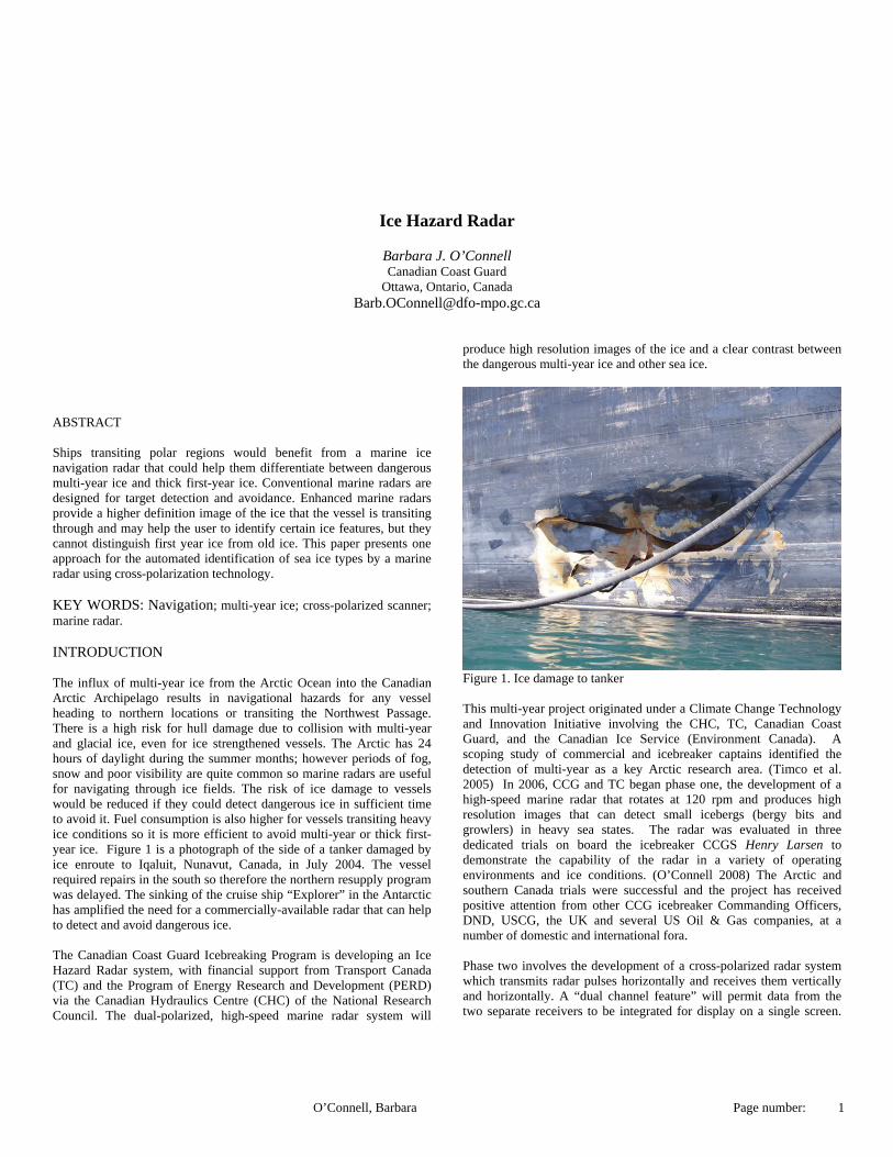
ABSTRACT Ships transiting polar regions would benefit from a marine ice navigation radar that could help them differentiate between dangerous multi-year ice and thick first-year ice. Conventional marine radars are designed for target detection and avoidance. Enhanced marine radars provide a higher definition image of the ice that the vessel is transiting through and may help the user to identify certain ice features, but they cannot distinguish first year ice from old ice. This paper presents one approach for the automated identification of sea ice types by a marine radar using cross-polarization technology. KEY WORDS: Navigation; multi-year ice; cross-polarized scanner; marine radar. INTRODUCTION The influx of multi-year ice from the Arctic Ocean into the Canadian Arctic Archipelago results in navigational hazards for any vessel heading to northern locations or transiting the Northwest Passage. There is a high risk for hull damage due to collision with multi-year and glacial ice, even for ice strengthened vessels. The Arctic has 24 hours of daylight during the summer months; however periods of fog, snow and poor visibility are quite common so marine radars are useful for navigating through ice fields. The risk of ice damage to vessels would be reduced if they could detect dangerous ice in sufficient time to avoid it. Fuel consumption is also higher for vessels transiting heavy ice conditions so it is more efficient to avoid multi-year or thick first-year ice. Figure 1 is a photograph of the side of a tanker damaged by ice enroute to Iqaluit, Nunavut, Canada, in July 2004. The vessel required repairs in the south so therefore the northern resupply program was delayed. The sinking of the cruise ship “Explorer” in the Antarctic has amplified the need for a commercially-available radar that can help to detect and avoid dangerous ice. The Canadian Coast Guard Icebreaking Program is developing an Ice Hazard Radar system, with financial support from Transport Canada (TC) and the Program of Energy Research and Development (PERD) via the Canadian Hydraulics Centre (CHC) of the National Research Council. The dual-polarized, high-speed marine radar system will
produce high resolution images of the ice and a clear contrast between the dangerous multi-year ice and other sea ice.
Figure 1. Ice damage to tanker This multi-year project originated under a Climate Change Technology and Innovation Initiative involving the CHC, TC, Canadian Coast Guard, and the Canadian Ice Service (Environment Canada). A scoping study of commercial and icebreaker captains identified the detection of multi-year as a key Arctic research area. (Timco et al. 2005) In 2006, CCG and TC began phase one, the development of a high-speed marine radar that rotates at 120 rpm and produces high resolution images that can detect small icebergs (bergy bits and growlers) in heavy sea states. The radar was evaluated in three dedicated trials on board the icebreaker CCGS Henry Larsen to demonstrate the capability of the radar in a variety of operating environments and ice conditions. (O’Connell 2008) The Arctic and southern Canada trials were successful and the project has received positive attention from other CCG icebreaker Commanding Officers, DND, USCG, the UK and several US Oil & Gas companies, at a number of domestic and international fora. Phase two involves the development of a cross-polarized radar system which transmits radar pulses horizontally and receives them vertically and horizontally. A “dual channel feature” will permit data from the two separate receivers to be integrated for display on a single screen.
O’Connell, Barbara Page number: 1

Real-time processing of the polarized data displayed in an RGB colour space would provide a clear contrast between multi-year ice, first-year ice and other types of ice and open water. This paper will describe the past and current technology related to the classification of ice types by radar sensors using cross-polarization and how the Canadian Coast Guard intends to incorporate the technology into the Ice Hazard Radar. MICROWAVE SENSING OF SEA ICE New sea ice is very salty because it contains concentrated droplets called brine that are trapped in pockets between the ice crystals. As ice ages, the brine drains through the ice and by the time it becomes multi-year ice, nearly all the brine is gone leaving empty cavities and drainage channels. Sea ice types have very different physical properties, ranging from essentially freshwater ice in refrozen melt ponds, to very saline new ice to extremely porous ancient multi-year ice. Multi-year ice is ice that has survived a summer melt season and is much thicker than younger ice, typically ranging from 2 to 4 metres thick, with ridges up to 20 metres. (Carsey 1992) Microwave satellite sensors can detect the different electromagnetic properties of first-year and multi-year ice. In general, thicker multi-year ice is readily distinguishable from the younger, thinner ice because radar energy bounces back to the sensor from the bubbles in the ice left when brine drains. Synthetic aperture radars (SAR) are very useful tools for measuring the extent of thick and thin sea ice. (EoE 2010). Data from single-channel SARs, such as the one on RADARSAT-1, however, are limited somewhat in their ability to identify ice types. Polarimetric SARs, such as RADARSAT-2, provide additional information that can address difficulties in ice interpretation and analysis. (NRCan 2007) RADARSAT-1 is horizontally polarized, meaning the radar wave is horizontal to the Earth’s surface. RADARSAT-2 has the capability to send and receive data in both horizontal (H) and vertical (V) polarizations. Images acquired with the various combinations of polarizations on transmit and receive can be displayed on single channels or in various combinations including ratios and false colour composites.
Figure 2. RADARSAT polarization modes (MDA 2008) RADARSAT-2 images analysed by the Canadian Ice Service, Environment Canada, clearly demonstrate the advantages of cross-polarized and colour composite images. The following images were taken on September 14, 2008 in M’Clure Strait. Figure 3 is an HH polarization (horizontal send and horizontal receive). In the image, it is difficult to differentiate the multi-year ice from other ice types.
Figure 3. RADARSAT-2 HH image of M’Clure Strait (MDA 2009) Cross-polarization modes combine horizontal send with vertical receive (HV) or vice versa (VH). In the following HV image (Figure 4) the multi-year ice clearly stands out but the thinner ice types are not as evident.
Figure 4. RADARSAT-2 HV image of M’Clure Strait. (MDA 2009) A combination of HH, HV and RGB221 images help to differentiate all the ice types. Figure 5 is an RGB221 image with very good detection of multi-year ice, along with an increased detection of strips of thinner ice.
O’Connell, Barbara Page number: 2
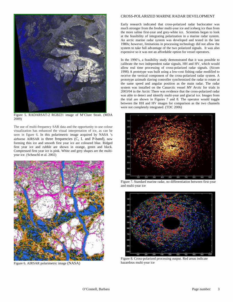
Figure 5. RADARSAT-2 RGB221 image of M’Clure Strait. (MDA 2009) The use of multi-frequency SAR data and the opportunity to use colour visualization has enhanced the visual interpretation of ice, as can be seen in figure 6. In this polarimetric image acquired by NASA ‘s airborne AIRSAR in three frequencies (C, L and P-band), new forming thin ice and smooth first year ice are coloured blue. Ridged first year ice and rubble are shown in orange, green and black. Compressed first year ice is pink. White and grey shapes are the multi-year ice. (Scheuchl et al. 2002)
Figure 6. AIRSAR polarimetric image (NASA)
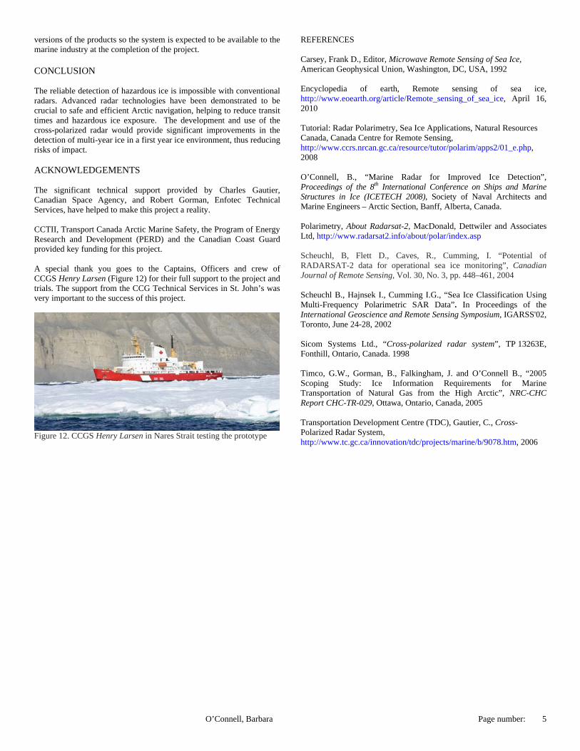
CROSS-POLARIZED MARINE RADAR DEVELOPMENT Early research indicated that cross-polarized radar backscatter was much stronger from the fresher multi-year ice and iceberg ice than from the more saline first-year and grey-white ice. Scientists began to look at the feasibility of integrating polarization in a marine radar system. An arctic marine radar system was developed and tested in the late 1980s; however, limitations in processing technology did not allow the system to take full advantage of the two polarized signals. It was also expensive so it was not an affordable option for vessel operators. In the 1990’s, a feasibility study demonstrated that it was possible to calibrate the two independent radar signals, HH and HV, which would allow real time processing of cross-polarized radar signals. (Sicom 1998) A prototype was built using a low-cost fishing radar modified to receive the vertical component of the cross-polarized radar system. A prototype azimuth slaving controller synchronized the radar to rotate at the same speed and angular position as the main radar. The radar system was installed on the Canarctic vessel MV Arctic for trials in 2003/04 in the Arctic There was evidence that the cross-polarized radar was able to detect and identify multi-year and glacial ice. Images from the trial are shown in Figures 7 and 8. The operator would toggle between the HH and HV images for comparison as the two channels were not completely integrated. (TDC 2006)
Figure 7. Standard marine radar, no differentiation between first-year and multi-year ice
Figure 8. Cross-polarized processing output. Red areas indicate hazardous multi-year ice
O’Connell, Barbara Page number: 3

ICE HAZARD RADAR DEVELOPMENT Significant improvements in marine radars and radar processing have increased the ability to build a cross-polarized, high-speed radar for improved ice detection. The high-speed master radar installed on CCGS Henry Larsen in phase one of the Ice Hazard Radar project has proven itself to be an integral tool for the bridge navigation team, helping to define floe shapes and open water leads in the ice. In figure 9, the icebreaker is seen in the centre, escorting a cargo vessel though leads between first year ice floes.
Figure 9. Radar image of first year ice. The Ice Hazard Radar system will consist of two high-speed radar scanners when it is completed. The master high-speed scanner transmits and receives in horizontal polarization (HH). In March 2009, development began with a second, off-the-shelf radar, a Bridgemaster x-band radar, which was also modified to rotate at 120 rpm. The scanner was replaced with a vertically-polarized antenna and set to receive-only (HV). The slave radar scanner was synchronized to the transmitting master radar in rotation, frequency, and pulse timing. Figure 10 (below) is a diagram of the radar system.
Figure 10. Radar schematics The scanners were tested in cold temperatures, high winds and heavy
vibration in order to ensure they would be rugged enough to withstand continuous operation onboard the icebreaker in extreme Arctic conditions. The following is an artist’s rendition of the two antennas on the mast of CCGS Henry Larsen. (figure 11)
Figure 11. Graphical representation of the scanners aboard the icebreaker. The next step of the project will be to integrate the HH and HV signals from the receivers and to develop algorithms to display the images on a single screen. The user will be able to switch between the typical HH image of the ice, to the HV image or to the fused HH/HV image. The intention is to generate coloured HH/HV radar images instead of the usual grey-scale images, with multi-year ice a distinct colour from first-year ice. As mentioned earlier, the cross-polarized radar is sensitive to the physical properties of sea ice (salinity, microstructure, and surface roughness) that vary with ice concentration, type, age and thickness. Shallow incidence angles are more effective in highlighting surface topography, separating the ice/water boundary, and detecting icebergs. The vertically polarized scanner and upgrades will be installed on CCGS Henry Larsen. Trials of the system will be conducted off the Labrador Coast during the winter and in the Arctic in the summer of 2011 to validate the ability of the radar to discriminate between multi-year and first year ice. A sufficient quantity and diversity of data will be collected in order to analyze and evaluate of Ice Hazard Radar objectively and systematically. RADARSAT-2 polarimetric imagery, photographs and videos of the ice will be acquired. Ice Service Specialists will ground-truth the ice types and, if available, DFO will provide additional support with the of the Helicopter Fixed Mount Electromagnetic-Induction Ice Thickness Sensor (EISFlow) developed by Geosensors Inc. of Toronto. Following the completion of the Arctic trial, a final report will be produced to conclude the project, include recommendations from the end-users on the system and a full description of the trial data and the material collected during the trial. The final report will be delivered along with any additional material such as radar data, satellite imagery, photographs and videos, and any other material relevant to the project and subsequent tasks. The project has inter-operability capabilities with existing and other innovative technologies. The high-definition radar image can be overlaid on marine electronic navigation systems, for example, the ICAN Aldebaran II charting system on board CCGS Henry Larsen, enhancing the usefulness of the radar imagery. Two companies have expressed an interest in producing commercial
O’Connell, Barbara Page number: 4
versions of the products so the system is expected to be available to the marine industry at the completion of the project.
REFERENCES Carsey, Frank D., Editor, Microwave Remote Sensing of Sea Ice, American Geophysical Union, Washington, DC, USA, 1992
CONCLUSION
Encyclopedia of earth, Remote sensing of sea ice, http://www.eoearth.org/article/Remote_sensing_of_sea_ice, April 16, 2010
The reliable detection of hazardous ice is impossible with conventional radars. Advanced radar technologies have been demonstrated to be crucial to safe and efficient Arctic navigation, helping to reduce transit times and hazardous ice exposure. The development and use of the cross-polarized radar would provide significant improvements in the detection of multi-year ice in a first year ice environment, thus reducing risks of impact.
Tutorial: Radar Polarimetry, Sea Ice Applications, Natural Resources Canada, Canada Centre for Remote Sensing, http://www.ccrs.nrcan.gc.ca/resource/tutor/polarim/apps2/01_e.php, 2008 ACKNOWLEDGEMENTS O’Connell, B., “Marine Radar for Improved Ice Detection”, Proceedings of the 8th International Conference on Ships and Marine Structures in Ice (ICETECH 2008), Society of Naval Architects and Marine Engineers – Arctic Section, Banff, Alberta, Canada.
The significant technical support provided by Charles Gautier, Canadian Space Agency, and Robert Gorman, Enfotec Technical Services, have helped to make this project a reality.
Polarimetry, About Radarsat-2, MacDonald, Dettwiler and Associates Ltd, http://www.radarsat2.info/about/polar/index.asp
CCTII, Transport Canada Arctic Marine Safety, the Program of Energy Research and Development (PERD) and the Canadian Coast Guard provided key funding for this project.
Scheuchl, B, Flett D., Caves, R., Cumming, I. “Potential of RADARSAT-2 data for operational sea ice monitoring”, Canadian Journal of Remote Sensing, Vol. 30, No. 3, pp. 448–461, 2004
A special thank you goes to the Captains, Officers and crew of CCGS Henry Larsen (Figure 12) for their full support to the project and trials. The support from the CCG Technical Services in St. John’s was very important to the success of this project.
Scheuchl B., Hajnsek I., Cumming I.G., “Sea Ice Classification Using Multi-Frequency Polarimetric SAR Data”. In Proceedings of the International Geoscience and Remote Sensing Symposium, IGARSS'02, Toronto, June 24-28, 2002
Sicom Systems Ltd., “Cross-polarized radar system”, TP 13263E, Fonthill, Ontario, Canada. 1998 Timco, G.W., Gorman, B., Falkingham, J. and O’Connell B., “2005 Scoping Study: Ice Information Requirements for Marine Transportation of Natural Gas from the High Arctic”, NRC-CHC Report CHC-TR-029, Ottawa, Ontario, Canada, 2005 Transportation Development Centre (TDC), Gautier, C., Cross-Polarized Radar System, http://www.tc.gc.ca/innovation/tdc/projects/marine/b/9078.htm, 2006
Figure 12. CCGS Henry Larsen in Nares Strait testing the prototype
O’Connell, Barbara Page number: 5