Embed Size (px)
Citation preview
A A MCDfigirL(
A
BNIVIA1 '±DSSVOSI/V\
'13SSVOSIM
t •
•
, Li•
thilotert
-in.11„ lir': it
,
Ord
, c-iktegye
1
Report of the Wiscasset Waterfront Committee
to theBoard of Selectmen and the Citizens of Wiscasset, Maine
Prepared by
Holly Dominie Stroudwater Design Group Land Use Consultant Landscape Architects (Sr Planners
in conjunction with
Woodlot Alternatives, Inc. Environmental Consultants
Special Consultant Kenneth Fredette
October, 1990 Revised September, 1991
by Stroudwater Design Group
"Financial Assistance for preparation of this document was provided by a grant from
Maine's Coastal Program through funding provided by the U.S. Department of Commerce,
Office of Ocean and Coastal Resource Management, under the
Coastal Zone Management Act of 1971, as ammended"

1 1 1 1 1 1 1 1 1 1 1 1 1 1
PROJECT PARTICIPANTS WATERFRONT COMMITTEE Dan Thompson - Chairman
Don Brewer - (Wiscasset Recreation Department)
Norma Gordon
Harry and Barbara Haggett
Clari Holmkvist
Frank Menair
Bill Phinney - (Town Land Acquisition Committee)
Cheryl Rust
Walter Sherman
James and Jean Sutter
William C. Sutter - (Town Harbor Master)
Dick Thomas
Nate Whitaker - (Central Maine Power)
TOWN PROJECT ADMINISTRATOR Dan Thompson - Town Planner
Tom Eaton - Town Engineer
DESIGN TEAM Holly Dominie - Project Director
Town Planner Consultant
P.O. Box
Manchester, Maine 04351
(207) 622 - 0726
Stroudwater Design Group
Landscape Architects & Planners
1258 Westbrook Street
Portland, Maine 04102
(207) 871 - 1524
Woodlot Alternatives, Inc.
Environmental Consultants
54 Cumberland Street
Brunswick, Maine 04011
(207) 729 - 1199
Kenneth W. Freddette
Special Consultant
GRAPHIC LAYOUT AND DESIGN Stroudwater Design Group
CITIZENS Angie Andrews
Annie's Book Stop
Patricia Stauble Antiques
Area's Gift Shop
Clint Bardo
Joanna Bardo
William Barnes
Ann Beattie
Susan Blagden
Willaim Bowers
Don Brewer
Brobeck Collection/C3 Gallery
Katherine Brown
Kerstin Brown
Carriage Motors, Inc.
Coastal Business Center
Oscar Cronk
Edgecomb Inn
Tim Ellis
Fairfield of W scasset

Bill & Claire Gardener
Olcott Gates
William Glennon
Norma Gordon
Jeffery D.D.S. Grosser
Harry & Barbara Haggett
Frank Hammond
James Hammond
Hasenfus Gallery
Jean Hawes
Denis Hebert
Clari Hohnkvist
Dennis Jumper
Key Bank
Benjamin Kirkland
Melinda Lake
LaGarage Restaurant
Seaver Leslie
Marion Lowndes
Maine Coast and Color Works
Frank Menair
William and Jodi Morison
Paul and Sharon Mrozinski
New Cargoes
Pendleton's Market & Pharmacy
Penguin Computing
Harry E. Percival, Jr.
William & Donna Phinney
Margeurite Rafter
Red's Eats
Joe Reed
JoAnn Reidy
Roy Farmer Association
Cheryl Rust
S. & P. Bait Company
Sarah's Pizza and Cafe
Russel Schneider
Sheepscot River Pottery
Walter & Betty Sherman
Mary Minor Smith
Margaret Stetson
Martha Stetson
James & Dean Sutter
The Butterstamp Workshop
The Marston Housr Bed & Breakfast
Richard Thomas
Dan Thomas
Treats
Tree House Tavern
Two at Wiscasset Antiques
Grace Valentine
Village Hardware
Nate Whitaker
Wiscasset Bay Gallery
Wiscasset Hardware Co., Inc.
Wiscasset Home Laundermat
Wiscasset Newspaper
Ruth Wright
!pi
99 59
79
Z9
Z9
09
69
69
69 Z9 99 cc tg IS lc 8P CP
OP' 91 cc cc Sr 9C
CC
CC
11 LC 6? a
SSDDV Dflfld
NOI.01100211NI
lc133NO) INON1113AIN
atna:ney
puopn
Japan:ND IINISIA
184D0J1310 DIJOISH-1
21310VelVHD 1YflSIA CINV sow prism
pocullod 8uppod
Jo(mitim
Ili*ItsaPad ssaw Dwind
SISAWNV aupow puoidn
494!90H Alowwns Japan:ND fons!A
camped, illng
sma!A sainjoaj
uoppo4u1 JapoJEND Ions!A
:mammy )pcns!H
213.1.DV2JVHD1WISIA ONV DIPIOISIH new lonsm
pocupd fluppod
-91tItiaA uomsapad
a a a LZ
9Z
SZ
91
PrZ
PZ
PrZ 1/1
CZ
CZ
CZ
CZ
ZZ
tl IC
E
1.
9
5
ix xi
ssa,30 Dmind
ANO1N3ANI
NouonaouNI SISAWNY UNY ANOIN3ANI
Namsla SD21110S311 3NINVW
NJ:KWH Airno pons!A
sampaA 40n8 sainpaj panyoN
N31DVIIVHD 1WISIA ONV DIZIOISIH poolpzi
Buapod
KII"D!trA uoplsapad
SS3DDY DiPand
S311SSI A3N
ONILL3S S31155I A3N (INV ONIJJ3S
IN01112131VM 311140 NOLL110A3
NOINZINVOHO
SdOHSNNOM dr10210 A3MIS S3AILD31.90 ONINNVld
NVld NZIOM 31-11 SS33011/1 3111
3SOM (Id
pJOAAJOJ
sHcinix3 p
SiN3INO) JO 31OVI
Pedestrian 65 VILLAGE WATERFRONT MASTER PLAN 91 Vehicular 68 INTRODUCTION 91 Parking 68 CONCEPT "A" 91 Railroad 68 CONCEPT "B" 96 Visual Access 69 CONCEPT "C" 102 HISTORIC AND VISUAL CHARACTER 69 FINAL MASTER PLAN 103 Historic Character 69 Visual Character 69 UTERATURE CITED 119 WILDLIFE HABITAT 70 Upland 70 APPENDIX A Marine 70 IMPLEMENTATION PLAN 121
DESIGN/PLANNING PRINCIPLES 71 APPENDIX B INTRODUCTION 71 COASTAL WILDLIFE CONCENTRATIONS 125 CLARK'S CREEK 71 Location and Character 71 APPENDIX C Public Access 71 SPECIES LIST 126 Historic and Visual Character 73 Habitat 74 APPENDIX A VILL4GE WATERFRONT 76 MEETING SURVEY 127 Location and Character 76 Public Access 76 Historic and Visual Character 77 Habitat 79 VILLAGE HARBOR 80 Location ond Character 80
Public Access 80 Historic and Visual Character 81 Habitat 82 BACK RIVER 84 Location and Character 84 Public Access 84
Historic and Visual Character 85 Habitat 88
LIST OF EXHIBITS
Exhibit 1 - Study Area xi Exhibit 2 - Character Areas 6 Exhibit 3 - Survey Results 7 Exhibit 4 - Historic Villages 13 Exhibit 5 - Early Settlement 14 Exhibit 6 - Shipping Center 15 Exhibit 7 - Waterfront Warehouses 16 Exhibit 8 - Knox and Lincoln Rail Line 17 Exhibit 9 - Wiscasset & Quebec Rail Line 18 Exhibit 10 - Wiscasset Waterfront 19 Exhibit 11 - Regional Setting 21 Exhibit 12 - Village Center 22 Exhibit 13 - Character Areas 27 Exhibit 14 - Pedestrian Access 28 Exhibit 15 - Vehicular Access 30 Exhibit 16 - Narrow Gauge Rail 32 Exhibit 17 - Village Skyline 33 Exhibit 18 - Natural Features 34 Exhibit 19 - Views 36 Exhibit 20 - Built Features 38 & 39 Exhibit 21 -Hesper and Luther Little Schooners 40 Exhibit 22 - Habitat 44 & 45 Exhibit 23 -Barriers to Pedestrian Access 52 Exhibit 24 - Barriers to Vehicular Access 55 Exhibit 25 - Riverfront Concept 66 & 67 Exhibit 26 - Old Ferry Landing 86 & 87 Concept "A" 94 & 95 Concept "B" 100 & 101 Concept "C" 104 Final Master Plan 111 & 112 Town Landing Perspective 114 & 115 Creamery Site Perspective 116 & 117
I x
FORWARD
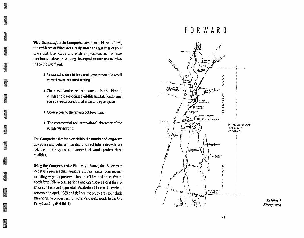
Exhibit 1 Study Area
1 1 1 1 1 1 1 1 1 1 1 1 1
With thepassage of the Comprehensive Plan in March of 1989,
the residents of Wiscasset clearly stated the qualities of their
town that they value and wish to preserve, as the town
continues to develop. Among those qualities are several relat-
ing to the riverfront
1 Wiscasset's rich history and appearance of a small
coastal town in a rural setting
The rural landscape that surrounds the historic
vi lage and ifsassociated wildlife habitat, floodplains,
scenic views, recreational areas and open space;
I Open access to the Sheepscot River; and
The commercial and recreational character of the
village waterfront.
The Comprehensive Plan established a number of long-term
objectives and policies intended to direct future growth in a
balanced and responsible manner that would protect these
qualities.
Using the Comprehensive Plan as guidance, the Selectmen
initiated a process that would result in a master plan recom-
mending ways to preserve these qualities and meet future
needs for public access, parking and open space along the riv-
erfront. The Board appointed a Waterfront Committee which
convened in April, 1989 and defined the study area to include
the shoreline properties from Clark's Creek, south to the Old
Ferry Landing (Exhibit 1).
xl
In December, 1989 the Selectmen, Town Engineer and Town Planner asked consultant Holly Dominie to organize a design team for helping the Committee refine its ideas i nto a workable plan. She and the town's planner and engineer selected the Stroudwater Design Group and Woodlot Alternatives to assist her.
Town staff and officials and a number of residents interested in the future ofWisrassefs riverfront have all worked together in this process to develop a common "vision" for guiding the future of the riverfront. All have shared the same sense of privilege associated with the planning of an area containing such a significant share of the historical, visual and environ-mental qualities which residents wish to protect and preserve. All have recognised the inherent challenge in protecting these qualities in the face of competing demands and changing land use.
Throughout this study a special effort has been made to learn directly from people their opinions about what the waterfront is now and could be in the future. This has been accomplished by conducting informal workshops with local officials, water-front landowners, and business owners within the Village Center. A high priority has been placed on listening to their concerns, hying to understand the many "visions" of what the water fiont could be from those who have influenced its past and present and will be involved with the evolution of ifs future. There were clearly some conflicting values that had to be addressed. As a result of the public workshops, a collective "vision" has been formulated that is expressed in the recom-mendations of this study.
Town Staff and The Design Team met several times to review the inventory and analysis, clarify issues, and develop alterna-tive approaches to the collective "vision" for the area of the Village Waterfront. In July of 1990 three alternatives for the Village Waterfront were presented to the residents of Wiscas-set. The townspeople reviewed and discussed the alternatives, and chose those ideas that they found to be the most desirable, practical and achievable. These ideas were then refined by the Design Team and incorporated into the final Master Plan for the Village Waterfront. This plan is incorporated into the Riverfront Study.
x li
1 1 1 1 1 1
1 1 1 1 1
1 1
WISCASSET, MAINE
VILLAGE WATERFRONT AREA-1990
111 1 1,11,q ,"

1 1 1 1 1 1 1 1 1 1 1 1 1
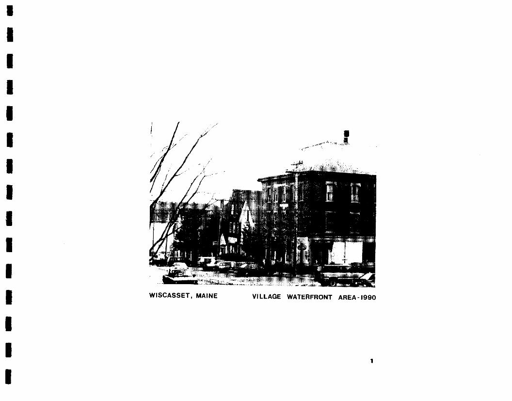
This document presents a Riverfront Study for the Sheepscot River from Clark's Point to the Old Ferry Landing. It includes a master plan for making improvements to the Village Water-front It is intended to function as a working reference to guide and coordinate the broad range of future planning and design decisions by those groups and individuals who are responsible for the future of the riverfront. The Study offers a framework for decision making and provides clear standards for imple-menting both shott and long term changes and improve-ments that will influence the physical access, environmental quality and visual character of the riverfront
This Study recommends distinct and understandable goals, guidelines for the riverfront and specific plans for the village
PURPOSE waterfront and Old Ferry Landing. It recommends how to provide and improve access to the Sheepscot River while pro-tecting the natural, visual and historic character of the river-front.
The Riverfront Study contains information on the quality of natural andbuiltconditionsand the types of uses whi ch best fit those conditions and the goals of the community. It identifies the major issues and specific ways in which competing de-mands can be resolved. Except for the vi llage waterfront, i t em-phasizes principles and policies over detailed solutions. In this way the recommendations provided by the Study can remain flexible as information and unforeseen events arise.
3
1 1 1 1 1 1 1 1 1 1 1 1
1
In preparing the Riverfront Study a five step process was followed. Those steps included:
) Inventory and analysis of the study area; Community workshops;
I The development of several schematic master plans for the Village Waterfront;
I The refinement of the schematic plans into one final Master Plan for the Village Waterfront; and
The development of design and planning principles for the riverfront.
The following is a brief summary of the process.
TM WORK PLAN
The Design Team assembled existing data, inventories and studies available from federal, state, local and private sources; and organized and evaluated that information to determine i t's relevance to the development of the Riverfront Study. Once the review of existing information was completed, additional data, inventory and field surveys necessary for a comprehen-sive analysis were identified and completed. An initial walking survey of the town waterfront with town officials was first conducted to i dentify specific issues and concerns, followed by a more thorough field survey of the entire study area. This survey identified important natural features (i.e. vegetative cover and wildlife), cultural features (i.e. development pat-terns and historical sites) and visual characteristics.
At the completion of the field surveys, the Design Team consolidated its data and utilized an overlay method of analysis to identify four areas of distinct character within the study
THE P ROCESS area. These areas (Exhibit 2) were identified for having dis-tinctly different physical and visual traits:
Clark's Creek Village Waterfront Village Harbor Back River
From this analysis the Design Team developed a preliminary concept forthepurposesofdiscussing the type of activities that the residents of the Town would be interested in encouraging along the riverfront. This discussion took place at a public meeting in March 1990 where participants brought forward several concerns and a variety of personal "visions" that they were interested in exploring. Meeting participants directed the Design Team to limit conceptual master planning to the Village Waterfront only.
Subsequently, the Design Team worked closely with residents in a series ofworkshops to develop and refine their ideas for the future of the Village Waterfront. A number of workshops with local and state officials, as well as land and business owners along the waterfront were conducted. The workshops pro-vided an understanding of the issues and concerns that were important to each group.
The workshops provided the basis for development of several alternative conceptual plans for the Village Waterfront. The concepts were presented to town residents on July 18, 1990 in a public workshop forum to discuss the possible activities that might be appropriate for the Village Waterfront. This meeting provided a basisfor refinement of theassumptions and recom-
3

4- CLARK' Cete
AREA _ —6. —
VI LLACEE- WAT EJEF CM"(
VI LLA&E-HAK,tX7IZ. AZEA
EEAC.K. V E.IC
AREA
Exhibit 2 Character Areas
6
mendations for the final Village WaterfrontMaster Plan. These
assumptions and recommendations expressed how residents
of the Town currently use the waterfront; what they perceive as
its most valued characteristics and greatest problems; and
what their expectations are for its the future.
In addition to the workshops, a written opinion survey was
taken of the participants at the March 1st public meeting to set
community prioritiess.
RIVERFRONT PLANNING OBJECTIVES SURVEY
At the March I, 1990 public meeting, participants were asked
to rank the relative importance of a number of planni ng objec-
tives found in the Comprehensive Plan, and those that were
found to be of potential interest to the Town after the inventory
and analysis process. The intent was to determine the kinds of
uses which are deemed most appropriate for the riverfront. A special statistical consultant, Mr. Kenneth W. Fredette, was
hired to assist i n the tabulation and i nterpretation of the survey
results.
It should be noted that the survey is exploratory in nature and
was conducted to help set priorities of those who attended the
public meeting. These results were used in conjunction with
the opinions expressed in the comprehensive plan and the
workshops with waterfront residents to formulate a town
concesus on what should be accomplished along the water-
front.
The survey data indicated, and the March 1st discussion
reinforced, that respondents placed a higher priority on pro-
1 1 1 1 1 1 1 1 1 1 1 1 1 1
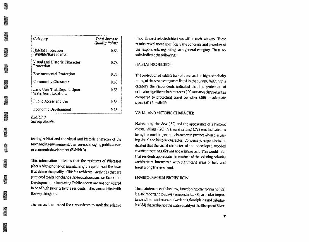
Category
Habitat Protection (Wildlife/Rare Plants)
Visual and Historic Character Protection
Environmental Protection
Community Character
Land Uses That Depend Upon Waterfront Locations
Public Access and Use
Economic Development
Total Average Quality Points
0.83
0.78
0.76
0.63
0.58
0.53
0.48
Exhibit 3 Survey Results
tecting habitat and the visual and historic character of the town and its environment, than on encouraging public access or economic development (Exhibit 3).
This information indicates that the residents of Wiscasset place a high priority on maintaining the qualities of the town that define the quality of life for residents. Activities that are percieved to alter or change those qualities, such as Economic Development or increasing Public Access are not considered to be of high priority by the residents. They are satisfied with the way things are.
The survey then asked the respondents to rank the relative
importance of selected objectives wi thin each category. These results reveal more specifically the concerns and priorities of the respondents regarding each general category. These re-sults indicate the following:
HABITAT PROTEC110N
The protection of wildlife habitat received the highest priority rating of the seven categories listed in the survey. Within this category the respondents indicated that the protection of critical or significant habitat areas (.90) was most important as compared to protecting travel corridors (.59) or adequate space (.61) for wildlife.
VISUAL AND HISTORIC CHARACTER
Maintaining the view (.80) and the appearance of a historic coastal village (.76) in a rural setting (.72) was indicated as being the most important character to protect when discuss-ing visual and historic character. Conversely, respondents in-dicated that the visual character of an undeveloped, wooded riverfront setting (.62) was not as important. This would infer that residents appreciate the mixture of the existing colonial architecture intermixed with significant areas of field and forest along the riverfront.
ENVIRONMENTAL PROTECTION
The maintenance of a healthy, functioning environment (.82) is also important to survey respondants. Of particular impor-tance isthe maintenanceofwetlands, flood plainsand tributar-ies (.84)that influence thewaterquality of the Sheepscotf6ver.
7
COWAUNITY CHARACTER
The community character of the village center was not given a
high priority rating by the respondents (0.63). They did
indicate, however, that if issues of community character were
considered, then the village center shou Id appear and function
in a logical, unified and attractive manner (.73).
WATER DEPENDENT USES
The survey found that while protecting wildlife habitat and the
environment had a higher priority than water dependent uses,
efforts should be made to ensure that appropriate sites were
available (27) for marine related activities. A working water-
front (.67) was not seen as an important priority over other
water dependent uses.
PUBIC ACCESS AND USE
Public access (0.53) was considered to be of one of the lowest
priorities of the seven surveyed planning objectives for the
ri verfront. The survey did indicate though, that if public access
to the water (.70) is considered, that it should cause little
disruption to the community (.84); that it should connect the
village center with surrounding neighborhoods and special
sites (.81); and that parking associated with public access sites
should be kept to a minimum (.80).
TAX BASE DIVERSIFICATION
This planning objecti ve received the lowest priority level (0.48)
of the survey. The improvement of the waterfront for eco-
nomic activity is clearly not a direction that the respondents
would like the waterfront to proceed in.
In summary, this survey data clearly suggests that habitat pro-
tection, particularly of critical or significant habitat areas is of
high priority when considering the future of the riverfront.
Residents are equally concerned about maintaining the ap-
pearance of the rural and historic qualities of the village. The
survey also indicates that they will be more tolerant of impacts
to the visual character of the waterfront if it is compatible with
the type of visual mix that currently exists between the natural
and built environments along the village waterfront. They
have also indicated that protection of the riverfront environ-
ment should be given a priority over encouraging further
economic development of the riverfront, which would result
in the addition of increasing numbers of buildings and related
improvements along the shoreline. Public access is not a well
received development along the riverfront unless it is village
oriented and has very little impact on community life.
This isa brief description of the data from the survey conducted
in March, 1990, and what the data infer about the community
"vision" of what the riverfront should be. A more detailed
explanation of the survey may be found in Appendix D.
GROUP WORKSHOPS
The workshops provided a better understanding of how the
residents perceive and would like to use the village waterfront
area. They provided an opportunity for residents within the
Village Waterfront Area, local officials and interested State
agencies to express their "visions" for the village waterfront.
1 1 1 1 1 1 1 1 1 1 1 1 1 1
The process involved dividing residents of the village water-front into small groups where they could discuss specific issues common to their neighborhood area. Three workshops targeted:
Landowners north of Lincoln Street to the old jail Landowners southof Lincoln Street to Whites Island
I Business owners in the village
Individual meetingswere also held with local officials, Central Maine Power, the Railroad Division Director for the Depart-ment of Transportation and the owner of Whites Island.
Each workshop group was asked to discuss their personal views of proposed improvements along the waterfront, what they liked or disliked about current conditions, and what type of future direction they would like to see for the waterfront. The three topics generating the most discussion centered on who the waterfront is for, the impact of the reactivated rail line on the waterfront, and how best to provide adequate parking and public facilities for water related uses. In general the following observations were made:
WATERFRONT USES
Future management and direction of the waterfront should accommodate foremost the needs and desires of the people who live in town. Priority should be given to residents who use existing facilities along the waterfront, such as the Town Landing.
I The impact of tourists needs to be better managed. Many of the issues which currently confront the waterfront, such as parking, public access and traffic congestion are seasonal impacts that occur at peak vacation times.
The establishment of a train stop on the waterfront for freight or passengers, should be discouraged, at the present time.
Public toilets should be located closer to the central business area of the village.
I Opinion is divided on the use of the Creamery Site. Ideas range from a passive viewing area to a joint venture devel-opment for extra boating slips.
PARKING AND ACCESS
The number ofparkingspaces needs to be increased in the village area. Small lots tucked between existing buildings is the most desired. Parking lots along the waterfront are not desired.
The demand for water access at the Town Landing has exceeded its capacity to effectively provide parking for boaters accessing the Sheepscot River.
I Pedestrian movement across Route One needs to be improved to reduce pedestrian/vehicular conflicts. Opin-ion is divided as to the best resolution for this issue. Considerations are: an underpass an overpass or a pe-destrian free zone.
II Developing more public access sitesalong the riverfront is
not encouraged because of the current problems that
tourism inflicts upon the town and the informal under-
standings that currently enable local people to use private
lands for river access. The concern is that those problems
will not lessen through additional public access but will
rather spread and possibly increase. If the only effect of in-
creased public access were that townspeople would have
an enjoyable place to stroll and access other parts of town,
then the support would be higher.
HABITAT
Joppa Cove and Whites Island areas should be maintained
in a natural setting. Habitat enhancement actions by
landowners are encouraged.
VISUAL CHARACTER
/ Visual intrusion by the sewage treatment plant is intoler-
able. New additions to the plant should be more architec-
turally sensitive than the existing plant buildings to the
town and planti ngs should be used to create a visual buffer
around the perimeter of the plant. Other places such as
the Town Landing are not visually attractive either.
The results generated from the public workshops, were incor-
porated by the Design Team into the development of three
alternative design concepts for the Village Waterfront. These
concepts were presented to town residents in Ju ly, 1990 wi th in
a workshop format. During this public meeting, participants
were able to review the plans, ask questions and make corn-
ments on each of the proposed concepts. Participants were
asked to evaluate how well each design concept addressed their
concerns and interests expressed in the previous workshops.
The final Village Waterfront Master Plan reflects the results of
thi s process, and incorporates what participants believed to be
the best aspects of each alternative.
10
1 1 1 1 1 1 1 1 1 1 1 1 1 1
The remainder of this report is organized to document the
findings, conclusions and recommendations of the Rive rfront
Study.
Chapter 4, "Evol ution of the Waterfront" presents an historical
overview of the major events that have occurred along the
riverfront so that the present environment can be understood
in terms of the decisions of the past.
Chapter 5, "Setting and Key Issues", discusses the current
condition of the riverfront and the issues that residents find to
be important along the riverfront.
Chapter 6, "Inventory and Analysis", discusses the character-
istics of the natural and built environments. Specifically,
access, the development pattern, and natural and built fea-
ORGANIZATION tures of the envi ronment are discussed. This analysis discusses
the key elements which create the image of a small New
England coastal village surrounded by open space.
Chapter 7, "Riverfront Concept", summarizes the analysis of
key elements and illustrates the key planning concepts and
actions that form the overall guidelines for the design im-
provements along the waterfront.
Chapter 8, 'Design and Planning Principles", presents a de-
tailed description of the specific opportuni ti es, constrai nts and
recommendations within each of the four identified character
areas along the riverfront.
Chapter 9.,"Village Waterfront Master Plan", presents a de-
tailed description of the schemetic concepts and the Final
Master Plan for the Village Waterfront. The timetable for the
final master plan is described in "Implentation Plan", (Appen-
dix A).
11
PEMbCLJIT
0
cit
Exhibit 4 Historic valages
13
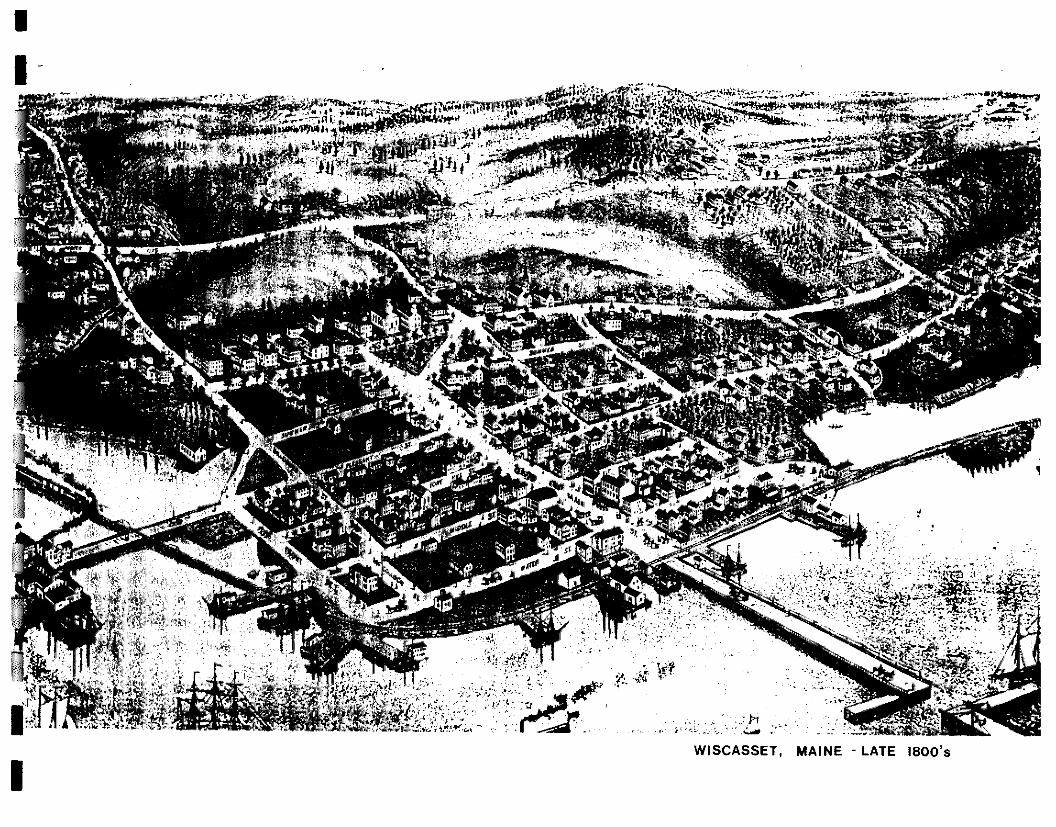
EVOLUTION OF THE WATERFRONT The origin for the name Wisrasset is believed to have come
from an Indian locative word meaning "confluence of three
rivets" or "the outlet of the bay". The definition for the term
"Wiscasset" continues to be debated among today's scholars.
However, little doubt exists that the rich natural resources
within the Sheepscot River corridor and the Town's access to
the open ocean had a significant influence on Wiseassers
prosperity and development (Exhibit 4).
Historically, the infertile and rocky conditions of the soil,
together with a short growing seasorh minimized the role that
farming hasplayed in the development of coastal communities like Wisrasset. The meager life-style offered by farming could
not compare to the riches and abundant opportunities that
were available in lumber, fishing and shipping along the rivers and the open ocean.
At the debouchure of the Sheepscot River, productive fishing
grounds produced such quantities of giant cod, mackerel and
flounder that by 1623, permanent fishing camps were estab-
lished atArrowsic Island, Sheepscot, Damariscotta, Pemaquid
and St. Georges. Eighty-four families were known to have
settled along the shores around the Kennebec and Sheepscot
Rivers by 1630. Great schools of salmon, shad, alewives,
striped bass, as well as beds of oysters could be found in the
upstream waters of the Sheepscot River.
Thisplentiful bounty encouraged settlementsalong the banks
of the Sheepscot River and in 1660 George DaNie and his
brother established a homestead at the current site of the
Lincoln County jail. However, colonial expansion was inhib-
ited by the Indian Wars from 1625 until 1725, the end of the

LOTTS OF LAND ON WEST SIDE OF
SHEEPSCUTT RIVER by the
Wiscmkseil romitany /762
( COMPOSITE I
74 QUARTER ACRE LOT TS
4
6'
8
.7./.28 WITS OF 100 ACRES EACH
Exhibit 5 Early Settlement
Governor Dummer's Indian War. Resettlement in the
confines of Wiscasset started again in 1729 with Robert
Hooper and his family moving to the Cushman Point area.
They were followed by several other settlers throughout
the 1700's.
During the 1730's the Boston Company, attracted by the
deep harbor and natural resources, bought the rights of
the Davie heirs and invested much of their energies and
money into the development of Wiscasset. Through their
efforts roads were built, jetties constructed and a village
development pattern began to evolve (Exhibit 5). The wa-
terfront at this time maintained its natural configuration
and direct access to the shoreline was common. Growth
and progress occurring in the early to mid 1700's estab-
lished Wiscasset as a shipping port. This enabled the town
to take advantage of the economic growth that was to
occur after the Revolutionary War in the shipping and
lumber industries and establish itself as a regional eco-
nomic center.
The beginning of the nineteenth century brought a re-
markable and prosperous expansion to the shores of the
Sheepscot River. The successful development of the fish-
ing and lumber industries brought an increase in demand
for lumber to build ships, and a need to expand shipping for
the export of fish and lumber, as well as the import of salt,
spices and other goods for commerce. \With it's vast
forests, rich fishing grounds and a deep water port that rarely froze during the winter months, Wiscasset was a
business center with no equal east of Portland. Shipping
flourished and the by-products of commerce enriched the
14
creer.mt
:644,
7f... • .,... J r—rt... • / • 4? TA:Con Pos- ); I J..", r i. 4 Sir
4 R ffi..4(.. ,r .46 at. 4,1„.(-4, /itt • ,,. * q , , • %pp.
Jr.'r F4 'Urn a 0.1, a
• sa "•..7 "'---. %to lett t/..64 '--,
)
ter
* in?..e. .• ern r an • . % frniirr •. a
,,,,, '1"4••■ V t• 1 2/1
a.of .(1
cix
( AS fSEv1s „ „," 1857.,
Exhibit 6 Shipping Center r
IS
1 1 1 1 1 1 1 1 1 1 1 1 1 1
inhabitants of Wiscasset.
This new wealth precipitated a period of rapid growth and
development that significantly altered the physical con-
figuration of the waterfront. Piers were constructed and
the shoreline stabilized to improve anchorage, and the
street grid of the village began to fill in with mills, store-
houses and the large homes of merchants and sea captains.
Although there was significant physical growth at this
time the village still focused on the waterfront with the
shoreline road being the primary access. At the peak of its
economic growth thirty-two merchant shipping vessels
and 122 fishing vessels would call Wiscasset their home
port. (Exhibit 6)
However, the economic wealth and prominence of Wicras-
set began to unravel with the shipping embargo of 1806
imposed by the British and French, and continued with the
embargo of 1807 imposed by America on its own shipping.
The final blow to the halcyon days of Wiscasset as a
shipping port came with the embargo of 1812.
The decline in shipping forced Wiscasset to diversify it's
economy in order to keep pace with other communities in
the area. With the decline of the shipping industry, the
mills along the Sheepscot River began to take a more
prominent role in the evolution of the waterfront. They
prospered from the early to the late 1800's, taking advan-
tage of the lumber and water resources that existed along
the Sheepscot River and it's tributaries. Tidal and under-
shot mills were common, and the remnants of such mill
sites exist at the mouths of Clark's Creek and Ward Brook.

erscot
site
aranreasepawr .PAPpe tanSaav. ,
~Aar OtAar area au an AannateAct 6aa atwantap
STaro AV La16,40, spawAn av PAP /slava arear AV Baia,. Jaffe AP JAMS LASIa'ir a Infant /a
rpA/ Lan LWOW
ge/InzeSE ortlenvi:Sz
I I tri
Exhibit 7 Waterfront
'Warehouses
16
These early mills manufactured planks, barrel staves, box
shooks and shingles for export directly to England, Scotland
and the West Indies.
The need to meet the increased demand for wood products
encouraged the specialization of the waterfront for the manu-
facturing and shipping of goods. This resulted in the construc-
tion of numerous mills and warehouses that were built out
into the river along the waterfront (Exhibit 7). The construc-
tion of large mills and piers dominated the shoreline and
blocked the water's edge from the street The specialization of
the waterfront and its physical separation from the village
encouraged the development of an alternative economic area
within the village center for the transaction of every day
commerce.
The development of steam powered portable mills in the mid
I800's contributed to the rapid reduction of the magnificent
forest along the Sheepscot River. Portable mills made it pos-
sible to harvest and mill vast quantities of wood at interiorsites
and eliminated the need to locate on the river for power and
transportation. This resulted in the overharvesting of timber
along the Sheepscot River. Concurrently, the construction of
mill dams, the pollution of waterways and the overfishing of
local fisheries led to the decline of the fishing industry.
Together, the despoiling of the resource base for both the
fishing and lumber industries so severely curtailed commerce
that the economic livelihood of the residents of WigrassPt
steeply declined.
As many local lumber mills closed in the 1870's, they were
quickly replaced by brick yards that took advantage of the
VILLAGE LINCOLN CO.
Scale 8.7,5 ft.' inch.
/
,
Knox Exhibit 81
and Lincoln Rail LineA
17
1 1
1 1 1
1 1
1 1 1 1
abundant amount of local clay soils. These yards never pro-vided the economic strength that the lumber and fishing industries had; they only delayed the economic decline of the town. The most profitable of the brick yards was the Tucker & Savage yard located along the river's edge at the foot of the hill where the narrow gauge rail line traverses the Middle School site,
The decline of these industries precipitated a corresponding decline in the town's prominence as an important economic pork The economy never fully rebounded to the robust levels of the early 1800's, settling instead into a stable residential community with a diverse mix of commercial and retail business concentrated in the village center.
The hope to regain some of its previous economic vitality was sparked when the Knox Sr Lincoln Railroad extended the standard gauge rail in 1871 from Woolrich to Rockland, thus completing the Boston to Roddand run. By this time the waterfront area had lost its vitality and several mills and warehouses along the waterfront were razed and additional land created to satisfy the spatial needs for the rail line (Exhibit 8). These changes effectively severed the waterfront from the town as the shoreline road became functionally less useful and its economic importance fit rther diminished, being overshad-owed by the village center.
TheKnox& Lincoln Railmad was never a financial success and it's construction placed the town of %%asset in severe debt until the early 1900's when it was purchased by Maine Central Railroad and later by Guilford Industries. Guilford Industries abandoned the line in 1979 and The Maine Department of
WI S CAS SE T TILLAGE
( COMPOSITE ) approx ; 1900
; Exhibit 9 Wiscasset Rail Line
■
Transportation (MDOT) purchased it in 1989. In June of 1990
MDOT leased the line to theMassachusettsCentral Railroad to
run freight from the Dragon Cement plant, in Thomaston, to
the State Pier at the Mason Station.
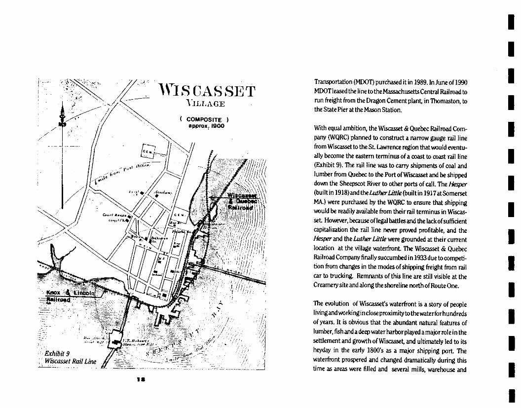
With equal ambition, the Wiscasset & Quebec Railroad Corn-
pany (WQRC) planned to construct a narrow gauge rail line
from Wiscasset to the St Lawrence region that would eventu-
ally become the eastern terminus of a coast to coast rail line
(Exhilfit 9). The rail line was to carry shipments of coal and
lumber from Quebec to the Port of Wicraccet and be shipped
down the Sheepscot River to other ports of call. The Hesper (built in 1918) and theLuther Little (built in 1917 at Somerset
Mk) were purchased by the WQRC to ensure that shipping
would be readily available from their rail terminus in Wiscas-
set. However, because of legal battles and the lack of sufficient
capitalization the rail line never proved profitable, and the
Hesper and the Luther Lit& were grounded at their current
location at the village waterfront The Vfiscasset dr Quebec
Railroad Company finally succumbed in 1933 due to competi-
tion from changes in the modes of shipping freight from rail
car to trucking. Remnants of this line are still visible at the
Creamery site and along the shoreline north of Route One.
The evolution of Wiscasset's waterfront is a story of people
living andworIcingincloseproximityto thevraterforhundreds
of years. It is obvious that the abundant natural features of
lumber, fish and a deep water harbor played a major role in the
settlement and growth of Wiscasset, and ultimately led to its
heyday in the early 1800's as a major shipping port The
waterfront prospered and changed dramatically during this
time as areas were filled and several mills, warehouse and
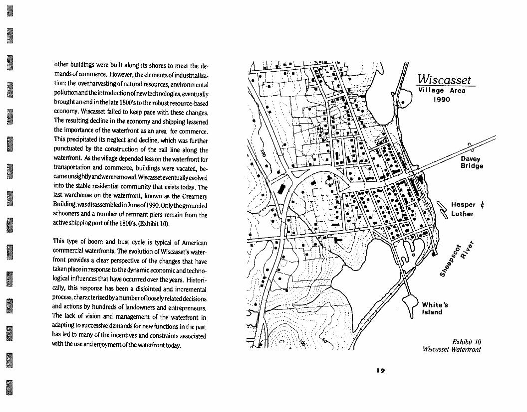
Wiscasset Vi I lage Area
1990
Davey Bridge
Hesper
Luther
White's Island
Exhibit 10 Wiscasset Waterfront
19
other buildings were built along its shores to meet the de-
mands of commerce. However, the elements of industrializa-
tion: the overharvesting of natural resources, environmental
pollution and the introduction of new technologies, eventually
brought an end in the late 1800's to the robust resource-based economy. WiCraqSPt failed to keep pace with these changes.
The resulting decline in the economy and shipping lessened
the importance of the waterfront as an area for commerce.
This precipitated its neglect and decline, which was further
punctuated by the construction of the rail line along the
waterfront. As the village depended less on the waterfront for
transportation and commerce, buildings were vacated, be-
cameunsightlyand wereremoved.Wiscasset eventually evolved
into the stable residential community that exists today. The
last warehouse on the waterfront, known as the Creamery
Building, was disassembled in June of 1990. Only the grounded
schooners and a number of remnant piers remain from the
active shipping port of the 1800's. (Exhibit 10).
This type of boom and bust cycle is typical of American
commercial waterfronts. The evolution of WisoscPt's water-
front provides a clear perspective of the changes that have
taken place in response to the dynamic economic and techno-
logical influences that have occurred over the years. Histori-
cally, this response has been a disjointed and incremental
proms, characterized by a number of loosely related decisions
and actions by hundreds of landowners and entrepreneurs.
The lack of vision and management of the waterfront in
adapting to successive demands for new functions in the past
has led to many of the incentives and constraints associated
with the use and enjoyment of the waterfront today.
Wiscasset is fortunate, either by chance or through direct
intention, to have maintained its historic architecture,
small town character and pedestrian scale of its village
center. These qualities are important particularly along
the riverfront, for it is along the riverfront that these at-
tributes coexist and form a special community resource
that is unique in it's potential to concurrently provide
diverse opportunities for economic growth, publ c enjoy-
ment and civic identity for Wiscasset residents.
The quality of life that Wiscasset currently enjoys can be
attributed to a balance between the types of economic uses
feasible along the riverfront and the types of uses that
instill civic pride and public enjoyment. This balance was
established during a slower, less complicated time when
changes in land ownership and economic development oc-
curred at a less rapid pace and smaller scale.
However, the effects of a rapid increase in the recreational
use and the encroachment of urban development along the
waterfronts of several southern and mid-coast Maine
communities has raised concern over the future of this
balance and the direction that the Wiscasset riverfront may take.
Most residents agree that it is important that Wiscasset's
riverfront remain attractive and accessible with a healthy
natural environment. They also agree that it's physical de-
velopment should be reflective of the Town's values and
ideals, and that marine related uses be given a priority
when considering the future development of the river-
front. Important in all of these concerns is the issue of
accessibility. What type of activities should have access to
the water? How much of the riverfront should be accessible
to the public?
20
21
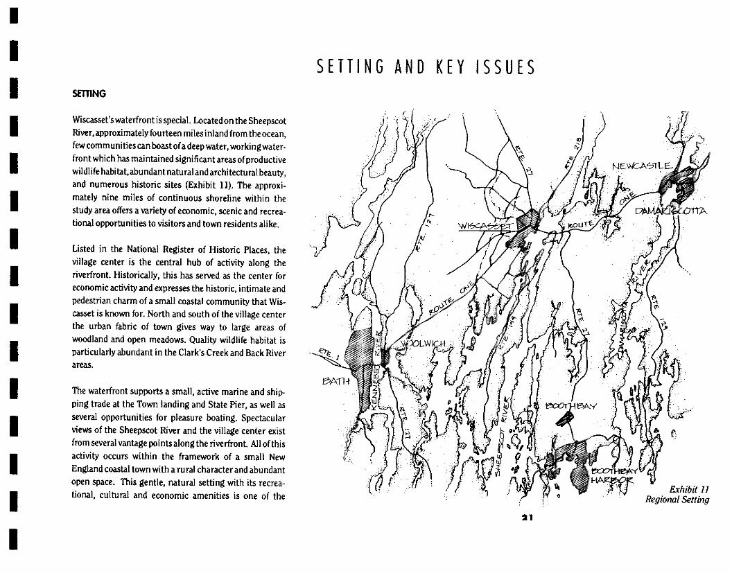
Exhibit II Regional Settfrig
SETTING AND KEY ISSUES SWING
Wiscasset's waterfront is special. Located on the Sheepscot River, approximately fourteen miles inland from the ocean, few communities can boast of a deep water, working water-front which has maintained significant areas of productive wildlife habitat, abundant natural and architectural beauty, and numerous historic sites (Exhibit 11). The approxi-mately nine miles of continuous shoreline within the study area offers a variety of economic, scenic and recrea-tional opportunities to visitors and town residents alike.
Listed in the National Register of Historic Places, the village center is the central hub of activity along the riverfront. Historically, this has served as the center for economic activity and expresses the historic, intimate and pedestrian charm of a small coastal community that Wis-cassPt is known for. North and south of the village center the urban fabric of town gives way to large areas of woodland and open meadows. Quality wildlife habitat is particularly abundant in the Clark's Creek and Back River areas.
The waterfront supports a small, active marine and ship-ping trade at the Town landing and State Pier, as well as several opportunities for pleasure boating. Spectacular views of the Sheepscot River and the village center exist from several vantage points along the rive rfront. All of this activity occurs within the framework of a small New England coastal town with a rural character and abundant open space. This gentle, natural setting with its recrea-tional, cultural and economic amenities is one of the

11, 11:00 ' !Id
reasons why Wiscacset is so special (Exhibit 12).
Exhibit 12 Village Center
Over the years the importance of Wicca cset as an economic center has steadily declined, while the interest in the quality of life within the town as a residential community has grown. The increase in the number of people wishing to visit or reside in Wiscasset has brought pressure upon the town's ability to maintain the historic, visual and environmental characteristics that define the town's qual-ity of life. These are attributes that the residents have iden-tified through numerous workshops and the Comprehen-sive Plan, as being important to the well being of the town.
To date the town has successfully provided a healthy balance between natural and built conditions. But this balance can not be taken for granted. The overflow from already crowded southern Maine towns and people's desire to live in more rural areas have made Lincoln county the State's fastest growing county. (1990 U.S. Census) This trend is expected to continue. The challenge for the town will be to manage continued growth in such a way as to maintain the high quality standard of living in the face of increasing demands for those qualities. With forethought, careful planning and dedicated attention to the details of implementation, it can be accomplished.
KEY ISSUES
The Comprehensive Plan gives explicit guidance about the kind of attention that townspeople would like given to their waterfront and it's associated land uses. The impor-tant issues facing the waterfront are those which threaten
22
to diminish it's environmental quality, easy access to the
river, historical image and visual character. The following
is a brief description of the key issues as identified through
the public workshops, the Comprehensive Plan and obser-
vation by the Design Team. Specific issues relating to the
village waterfront will be discussed in Chapter 8, "Design
and Planning Principles".
PUBUC ACCESS TO THE RIVERFRONT
PEDESTRIAN
to Poorly articulated pedestrian circulation routes across
Route One hinder the movement of pedestrians and
vehicles in the waterfront area. Current crossings are
poorly defined and difficult for pedestrians to navigate
with high seasonal traffic volumes.
I Reactivation of the rail line may generate the potential
for pedestrian/train conflicts that have not existed in
recent years.
I The lack of public property in some areas restricts
public access to the water.
I Incidents of vandalism and rowdy behavior on the
waterfront restricts the enjoyment of the riverfront by
town residents.
I Many of the public sites that provide pedestrian access
to the riverfront are auto-oriented and not inviting to
the pedestrian.
VEHICULAR
I Circulation conflicts with the reactivated rail line will
peroidically impede vehicular access to the water-
front area.
Lack of parking in the village inhibits vehicular access
for waterfront users.
I Seasonal increase in the number and type of vehicles
creates competition for limited parking spaces, limit-
ing vehicular access for water uses.
I Inefficient circulation patterns by people from out of
town looking for parking adds to the congestion on
village side streets.
lo Seasonal traffic volume on Route One impedes at-
tempts to cross this traffic corridor.
PARKING
I Lack of adequate parking does not support the full use
of available square footage of retail/office space in the village.
I Fluctuation in demand creates the seasonal lack of
adequate number of parking spaces, particularly in the
village center.
I The inefficient layout of existing parking lots contrib-
ute to the inadequate number of parking spaces.
23

Appropriate signage to efficiently direct drivers to existing available parking is lacking.
) Inadequate enforcement of parking regulations en-courages congestion of some lots.
I Lack of designated parking spaces for boat trailers and buses creates a shortage of parking spaces for cars around the town landing area.
RAILROAD
) The reactivation of the line may necessitate the redefi-nition of appropriate crossings to provide a safe envi-ronment along this corridor.
Reactivation of the rail line will create a number of conflict points between rail and pedestrian move-ment, and may impede the availability of public access to the waterfront.
• Increases in the use of the rail I in e will have some negative effects on the quality of li fe for residents and quality of wildl ife habitat areas.
The designation of MDOT lands, adjacent to the rail line corridor, exclusively for rail line activity would eliminate several recreation, public access and service uses that have become established while the rail corri-dor was in a state of abandonment.
Activi ties associated with the rail line, such as, parking storage and repairs could potentially have a negative effect on environmental, visual and the historic quali-ties valued by town residents.
HISTORIC AND VISUAL CHARACTER
NATURAL FEATURES
) Future development along the riverfront could re-move substantial portions of woodland and open fields that would diminish the important natural compo-nent of the visual character.
) Unrestricted and/or inappropriate public access could contribute to the physical deterioration of some natu-ral areas.
BUILT FEATURES
• Future development along the riverfront that is not in character with the existing built environment could diminish the image of a small New England coastal village.
I Deterioration, modification or removal of existing historic structures, remnants and historic sites could diminish historic and visual character.
24

1 1 1 1 1 1 1 1 1 1 LI 1 1 1
VISUAL QUAUTY
The Town wishes to protect the impression of a small New England coastal town of predominantly 18th and 19th century architecture and surrounding open space.
I Changes in existing land use patterns would alter the relationship within existing historic development pat-terns between the density of built structures, related open space and wooded areas.
Incremental encroachment by development on visu-ally sensitive areas along the shorefront would have a negative cumulative affect on the visual integrity of the area.
HABITAT
Inconsistent zoning along the riverfront does not pro-vide adequate protection for shoreline habitat.
• Encroachment by development within the proposed width of the Water Resource Protection District ef-fects habitat quality.
Mapping and classification of important nesting and habitat sites within the Sheepscot River corridor is important to the maintenance and management of healthy wildlife populations.
I Allowing indiscriminate public access into sensitive habitat areas by hikers and/or motorized vehicles, will
diminish and destroy the quality of wildlife habitat necessary for maintaining and managing healthy wild-life populations.
MARINE RESOURCES
The Town Landing and the Old Ferry Landing need to be improved to accommodate the increasing demand for water access by a variety of groups.
• The Town wishes to protect major stretches of saltwa-ter marshes and tidal flats to ensure a sound environ-mental base that will support commercial harvesting of marine resources.
I Physical improvements along the Village Waterfront should give priority to water-related uses.
DIRECTION
The direction provided by these issues is clear: the unique natural features, visual character and historic qualities are of great importance to the residents of Wiscasset. Because of these attributes and the quality of life that they collec-tively provide, the town of Wiscasset is a desirable commu-nity to live in.
There are at the same time certain aspects of growth and change that threaten these qualities. They are: tourism, the rail line, and new development to meet housing and commercial needs. The impact that they will put on the town to maintain its unique quality of living can be
23

accommodated if there is a commonly understood set of
objectives and a coordinated set of management policies.
The purpose of this study is to recommend such a set of
objectives and pol i ci es.
26
1 1 1 1 1 1 1 1 1 1 1 1 1 1
INVENTORY AND ANALYSIS INTRODUCTION
To ensure that the values expressed through the work-
shops and in the comprehensive plan were incorporated
into the Waterfront Access Plan, the Design Team con-
ducted a thorough inventory and analysis of the existing
conditions, features and policies in effect within the study
area. It specifically reviewed and studied the natural fea-
tures, the visual character, the historical and cultural
features, and the zoning and ownership patterns that
existed within and adjacent to the study area.
The Design Team compiled the data and analyzed it using
an overlay method that identified four distinct character
areas along the Wiscasset riverfront. These areas were
identified as: Clark's Creek, Village Waterfront, Village
Harbor and the Back River (Exhibit 13). Each character
area was defined by a unique combination of natural,
visual, historical and development pattern traits. These
zones were important in the analysis of the study area
because they provided cohesive physical units for develop-
ing planning and design principles for areas along the riv-
erfront. The following text describes the findings and con-
clusions of this inventory and analysis and highlights
important implications for planning and managing the
riverfront.
INVENTORY
PUBUC ACCESS
Pedestrian
The principle paths for pedestrian movement along the Exhibit 13
Character Areas 27
o RROAArE.- LANDOWNERS 4FIEGILWRD
INFORMAL 'WALK NG cura ALONG RAIL, CALLOLEWAS'
\ ILLA.f;P CENT-ESC REVESTIRAN TRAVEL FOUTE. ALOWs Dr/TEETS 4 .ivoir.o.Lic-,
o WATER ACCESS AT TOWN-OWNED StrED
0 INFORMAL. WATER ACC_FosYLL AT 1.;44- Ps., Nvor
ALONG KAM, LIME- o FEETEDLRIAN DRALVE-L-
AAFEDED ES( ROUTE OLLE.
o •Ect<A-KIAN Ace-r-e, ON WOOD enr,E. - TOWIQ FOTsHOOF- -WALT
0 INFORMAL. WALKING RDLOTE ALONG RAL CALIDEWAD
FRIvADE A:CGS, EDI LALNDOWNErrs 4 NEGGI-OLES
o INFORMAL REVESTPRAN rant ALSNG OLT; O-R-DADS Ow MAINE- SANKEF Wootacr
o rp,x) ,S-IzIAN WATER ACCESs' LS ALLOWED AD OLD FERRI' LANDING
REMOTE_ LLX_ATION TAMNIDT1E4 OPPORTUNITY
Ott, PEARY .LANIOMIG
Exhibit 19 Pedistrian Access
28
riverfront conform to the existing street grid within the village center and along Route 218 from the Clark's Creek bridge to the village center (Exhibit 14). Several informal routes exist along the rail causeways, the rail bed of the narrow gauge line and along the shoreline between the Creamery site and the Town Landing. Pedestrian move-ment around the village harbor is inhibited by land own-ership patterns and existing topography along the shore-line. Informal paths also exist south of the Mason Station along Cushman Hill and the Maine Yankee woodlot, north of the Old Ferry Landing.
The majority of river access sites along this system of paths and walks are concentrated along the Village Waterfront. These site are scattered along the shoreline and vary from such informal points as the Clishy Brook site, with an occasional visitor, to the more improved Town Landing which handles a high number of visitors seeking access to the river. No formal pathway system, other than existing roads or "desire lines" exists, which links these sites together to create a continual walking experience. Season-ally high traffic volumes on Route One impede pedestrian movement through the village and along the waterfront travelling in a north - south direction. Pedestrian access to the waterfront occurs along and across the rail bed in a random fashion without being confined to any particular routes or crossing points.
Additional town access exists at the terminus of several village street right-of-ways. However, because of the lim-ited space and long term established use of these areas by abutters, the practicality of using these sites for public
1 1 1 1 1 1 1 1 1 1 1 1 1 1
access is limited. A few sites exist north and south of the
Village Waterfront where public access is available on a
more informal basis to landowners, neighbors and friends.
North of the village center, in the Clark's Creek Area,
access to Clark's Creek and the Sheepscot River is limited
to the bridge crossing at Clark's Creek. No formal access
sites have been developed in this zrea. However, the Town
owns of a small parcel of land, just west of the bridge, that it
has improved as a turn-around for snow plows during the
winter months. No other lands are publicly owned. Resi-
dents in the area also access the shore of the Sheepscot
River along the abandoned rail bed on a informal basis.
This trail corridor is enjoyed by abutting land owners for
passive recreational uses (i.e. walking, bird watching etc.).
South of the Village Waterfront Area, access to the river-
front is limited. Within the Village HarborArea, access is
provided by a town right-of-way from the base of Pleasant
Street to White's Island, continuing across the harbor to
Birch Point. This right-of-way is sixteen feet in width and
has been improved by the Town with a wood pedestrian
bridge to White's Island. The Island, however, is privately
owned and public use is not openly encouraged. The re-
mainder of the land around the Harbor is privately owned,
with Central Maine Power being the largest land holder.
Town residents frequently use the existing train causeway
to traverse the harbor area. This activity will become
restricted in autumn of 1990, when the standard gauge rail
line is reactivated.
In the Back River Area, formal access is available at the Old
Ferry landing at the end of Ferry Road. The usefulness of
this site for pedestrian access is limited because of its
remote location. Several informal pedestrian access routes
exist along the many tote roads and paths that crisscross
this area.
The types of pedestrian environment along the riverfront
fall into two general categories. The areas north and south
of the Village Waterfront Area are characterized by travel
routes that follow the shoulders of existing roadways, and
by informal use of pathways that traverse private property
to access the water's edge. In general, these travel routes
function well to serve the type of low level, local pedestrian
use that occurs in these areas. The Village Waterfront, on
the other hand, is characterized by a much higher level of
pedestrian travel along the river and to specific access
sites. This pedestrian environment is more concentrated
with a larger number of people trying to access the water-
front either by foot or by car. The concentration of activi-
ties and users trying to access the area generates a number
of conflicts and the need for a more clearly defined and
efficient pedestrian system.
VEHICULAR
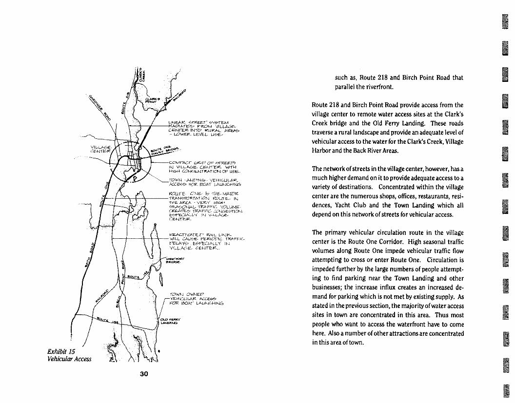
(Exhibit 15)
The roadway network within the riverfront study area can
be characterized as two distinct types:
The compact grid in the village center. I Linear roads that radiate from the village center,
29
LANE,Ate, aEar PKA raAcTta .om VC L A6E- CE-MIER INTO izug..64_ Pizeie - LOWEr- LF_VEL.
wet .
comoscr Gc.ir OP 45r9pv -r5 ViLLAGoE- wrn-f
kit&s4 CONIcE14TKATIOM OF U.
TOWN LAkinNe VEI-HCLILAg-KL-F_/-2.5 FOR. MAT LALMIC-FHLIC.,
gow- E MAWR TIZAW,FORTAllON gOUTe-- ei THE- AREA - \Ter( 1-41(.01-1 47E.A42*-141. -ilcArnc VOLUME-CKEAret, TRAP PC- CcxCsq1C*-4 EefEc4ALL NI ‘,6t-t_AGe-CEN1ER_
IzzE.Ac11vArEr RAJL LIKEE_ WILL, sAute rr-Kalc TRAFFic-raLA , VILLActe. CE_HTEV—,
1-OWKI owkw.v VENICULAR 4CCE2S reg t30.Al" LALILIC441KiG
FEA1Cf LJ4JOING
Exhibit 15 Vehicular Access
30
such as, Route 218 and Birch Point Road that
parallel the riverfront.
Route 218 and Birch Point Road provide access from the
village center to remote water access sites at the Clark's
Creek bridge and the Old Ferry Landing. These roads
traverse a rural landscape and provide an adequate level of
vehicular access to the water for the Clark's Creek, Village
Harbor and the Back River Areas.
The network of streets in the village center, however, has a
much higher demand on it to provide adequate access to a
variety of destinations. Concentrated within the village
center are the numerous shops, offices, restaurants, resi-
dences, Yacht Club and the Town Landing which all
depend on this network of streets for vehicular access.
The primary vehicular circulation route in the village
center is the Route One Corridor. High seasonal traffic
volumes along Route One impede vehicular traffic flow
attempting to cross or enter Route One. Circulation is
impeded further by the large numbers of people attempt-
ing to find parking near the Town Landing and other
businesses; the increase influx creates an increased de-
mand for parking which is not met by existing supply. As
stated in the previous section, the majority of water access
sites in town are concentrated in this area. Thus most
people who want to access the waterfront have to come
here. Also a number of other attractions are concentrated
in this area of town.
1 1 1 1 1 1 1 1 1 1 1 1 1 1
PARKING
In the Clark's Creek, Village Harbor and Back River Areas, and in the less developed areas of the Village Waterfront Area, parking is adequately accommodated by on-site lots for the many residences and business within theseareas. An exception to this is the limited public parking available at the Old Ferry Landing, a boat launch facility at the southern boundary of the Back River Areas. This lot is ex-tremely undersized for the type and extent of use that it receives and this effectively limits the number of people able to access the river from this location.
In the more developed area of the Village Waterfront Area, an inadequate number of parking spaces throughout the village center is a persistent problem in the peak summer and fall travel and vacation seasons. The most visible result of the limited parking available in the village center is that the seasonal parking demand creates congestion along streets in the village center as visitors and residents at-tempt to find parking and often park illegally out of frustration. This problem is particularly acute in the area of the village south of Route One and near the Town Landing, as an increased number of fishermen, visiting boaters, residents and patrons of nearby shops and restau-rants all attempt to use the limited parking available.
One of the less obvious effects that limited parking has on the village center is that it has hindered the full use of the upper floors of many commercial buildings that cannot provide enough parking to satisfy existing zoning require-ments.
The relative amount of open land available along the waterfront would appear to offer some relief by offering the opportunity to create additional parking spaces. However, this type of land use along the waterfront contrasts with a number of policy statements listed within the Comprehen-sive Plan and expressed at the workshops.
RAILROAD
Two existing rail lines traverse the riverfront study area. The former Wiscasset and Quebec rail line follows the contour line of the shore from the Creamery site in the Village Waterfront Area, northward to the mouth of Clark's Creek where it heads inland into Alna. Since it's abandon-ment in 1933 this rail line has become over grown with vegetation or removed to accommodate construction as-sociated with private residences, the Middle School, the Sewage treatment plant and Route One, which now trun-cates the rail line. A substantial part of this rail line exists today as remnant pilings along the shore of the village wa-terfront. (Exhibit 16)
Currently, the rail bed is informally used by local residents for hiking along the shoreline. It offes many spectacular views across the mouth of Clark's Creek and the Sheepscot River, as well as pleasant views up the several streams and creeks valleys along the shore. Consideration has beengi-ven to restoring the Wiscasset &Quebec rail line from Al na to the Davey Bridge. However, given the physical obstruc-tions that exist between these points this plan seems highly unlikely.
31
Exhibit 16 Narrow Gauge Rail
VISUAL ACCESS
Visual access to the riverfront is another type of access
which is highly important to town residents. Although
harder to define or protect than pedestrian, vehicular,
commercial or recreational access, it is arguably the most
important because it is available for all residents and
visitors to enjoy regardless of land ownership patterns or
other barriers to physical access along the riverfront. The
riverfront is highly visible by nature, however, the type of
visual access varies from location to location.
The Clark's Creek Character Area is highly visible from the
Route One bridge, the village waterfront and higher eleva-
tions within Town. Because of the high degree of visual
access to and from this area, the visual significance of this
zone is high. Many views of the rural and undeveloped
areas of Clark's Creek are available from Route One, Route
218, and by boat from the river.
The second rail line is the standard gauge rail line owned by
the Maine Department of Transportation (MDOT). This
line extends across the Village Harbor, northward along
the Village Waterfront and across the mouth of Clark's
Creek The rail causeways north and south of the Village
Waterfront are frequently used by the public to walk from
the White's Island area to the shore along Hilton Cove and
from Cow Island to Clark's Point This nil line will be
reactivated in the autumn of 1990 and it's effect on the
riverfront is expected to be minor, but has still not been
determined. However, use of the causeways for significant
pedestrian movement is likely to discontinue.
32
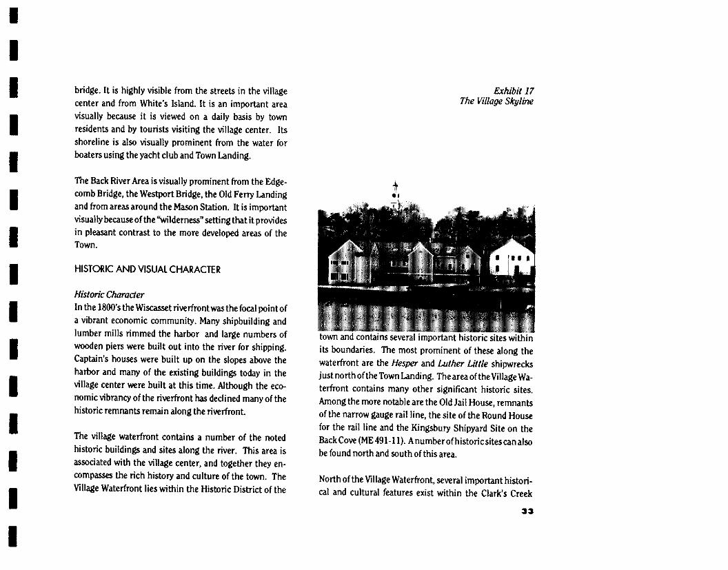
The Village Waterfront Area is highly visible from Route
One coming into and out of Town. Views from the Route
One Bridge headed west are of a compact and traditional
and picturesque coastal Maine village. Traveling east,
views are through the village streets and to the river and
opposite wooded shores. Many town residents enjoy the
unique opportunity of walking out onto White's Island
where the shoreline, the Village and its Skyline may be
viewed. (Exhibit 17)
The Village Harbor Area is visible at a distance while ap-
proaching Wiscasset from the west on the Route One
1 1 1 1 1 1 1 1 1 1 1 1 1 1
bridge. It is highly visible from the streets in the village
center and from White's Island. It is an important area
visually because it is viewed on a daily basis by town
residents and by tourists visiting the village center. Its
shoreline is also visually prominent from the water for
boaters using the yacht club and Town Landing.
The Back River Area is visually prominent from the Edge-
comb Bridge, the Westport Bridge, the Old Ferry Landing
and from areas around the Mason Station. It is important
visually because of the "wilderness" setting that it provides
in pleasant contrast to the more developed areas of the Town.
HISTORIC AND VISUAL CHARACTER
Historic Character In the I800's the WiscAtcPt rive rfront was the focal point of
a vibrant economic community. Many shipbuilding and
lumber mills rimmed the harbor and large numbers of
wooden piers were built out into the river for shipping.
Captain's houses were built up on the slopes above the
harbor and many of the existing buildings today in the
village center were built at this time. Although the eco-
nomic vibrancy of the riverfront has declined many of the
historic remnants remain along the riverfront.
The village waterfront contains a number of the noted
historic buildings and sites along the river. This area is
associated with the village center, and together they en-
compasses the rich history and culture of the town. The
Village Waterfront lies within the Historic District of the
Exhibit 17 The Village Skylble
town and contains several important historic sites within
its boundaries. The most prominent of these along the
waterfront are the Hesper and Luther Little shipwrecks just north of the Town Landing. The area of the Village Wa-
terfront contains many other significant historic sites.
Among the more notable are the Old Jail House, remnants
of the narrow gauge rail line, the site of the Round House
for the rail line and the Kingsbury Shipyard Site on the
Back Cove (mE 491- I 0. A number of historic sites can also
be found north and south of this area.
North of the Village Waterfront, several important histori-
cal and cultural features exist within the Clark's Creek
33
HE/WI WOOPEE2 PrEEER PLOPEe AFEE RsUALLY SU4SRHVE- r°L4ZER1YCOLILI7 NoSuALER .Se--RERAJ 12CRELOPmEt-11-
■ R Low E4rE.4erEY CAREFULLY ] -4-E,42
0 RA4C14VCORF. OF OREN °HELPS REAIKIAIRT- WCCit2LANE2s u4C4442E02 .044004.41. ■ 41E- 0ZuRAL ImRC4E4A4It- I-'O iNtu&E- OF ViLLPEEE.,
0 HIGH NclUAL.,1-444c4ErnVrrY lb CHAEIPE- 0UF tO Ort)-1
4402ERATF., &reEr r.,Locts
HIGHLY ERRORTAH1T AREA WoUALLY FOIR"NIALL, COALFAL TOW44 144AE2E4 - 44U I LT E4,,E4AE4 ,44 FIREPOMIMATF-
° 4VETLIRE1 , E1EFAE.44044 Inau upa, ZREG44E1.4.1 TREE4F,
,N,1 LA \OAF ,HILL&C4a IntraRARILY 601.E0 ACCON10.40044TEU 1,4EVELOPME-ka 41-1AF r0 IFI C-41ARACTER, WM-4 MC, MAC0E-
MEKE22 HSURL EARarE.H. 0 NATURAL E-LENIENTS IN2L1I0E-% LARGE
REAu2F4Erau12 LA4041O , LAIE&E , wOoper AREA," LARGE, OREN MASON STA/10N 4 rowER, LE-LE, Row
° AREA ImOoRrAarr lb \a/ILL-AL/E. NiA&E. a OREL-4 AREAs ARE- VERJALL-Y •>cuscr WE,
WC270E17 AREAS Cal LP A-ER-F.444 2rNE1-ORMER--1-1-
• HEAVILY WOCA7E-(7 - muck! OF R. REA is IJL42eyEAORE-1,
• -RTEER 4L0RES, 4 PROM i0.1F044- RE7C4E4-14144E, ARE- VIPLIALLCI OEFIOrrIVE, TO CHANGE-
▪ EOREST- C00122 VISUALLY .R.6E1-1 LOW INTRARRITY PEYELOPMENIE IE CAREFULLY EAT-EP
Exhibit 18 Natural Features L
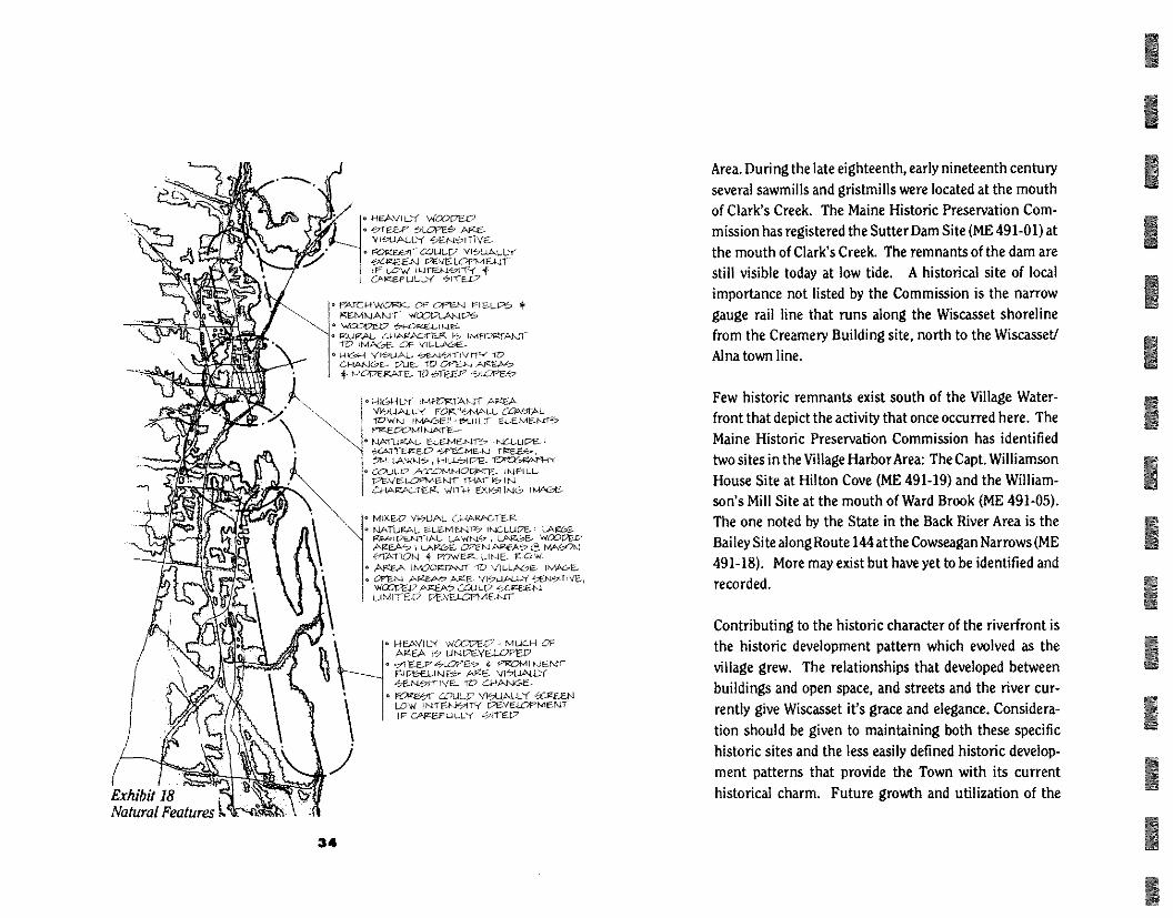
Area. During the late eighteenth, early nineteenth century several sawmills and gristmills were located at the mouth of Clark's Creek. The Maine Historic Preservation Com-mission has registered the Sutter Dam Site (ME 491-01) at the mouth of Clark's Creek. The remnants of the dam are still visible today at low tide. A historical site of local importance not listed by the Commission is the narrow gauge rail line that runs along the Wiscasset shoreline from the Creamery Building site, north to the Wiscasset/ Alm town line.
Few historic remnants exist south of the Village Water-front that depict the activity that once occurred here. The Maine Historic Preservation Commission has identified two sites in the Village Harbor Area: The Capt. Williamson House Site at Hilton Cove (ME 491-19) and the William-son's Mill Site at the mouth of Ward Brook (ME 491-05). The one noted by the State in the Back River Area is the Bailey Site along Route 144 at the Cowseagan Narrows (ME 491-18). More may exist but have yet to be identified and recorded.
Contributing to the historic character of the riverfront is the historic development pattern which evolved as the village grew. The relationships that developed between buildings and open space, and streets and the river cur-rently give Wiscasset it's grace and elegance. Considera-tion should be given to maintaining both these specific historic sites and the less easily defined historic develop-ment patterns that provide the Town with its current historical charm. Future growth and utilization of the
34
waterfront area should be developed to respect the histori-
cal heritage that the residents value.
Visual Character • Introduction
The Wiscasset riverfront has a diversity of physical condi-
tions that together create a dynamic visual environment.
These physical conditions range from areas dominated by
natural elements to areas composed entirely of built ele-
ments. The following discussion highlights the most
important of these:
• Natural Features
(Exhibit 18)
Undeveloped areas throughout the riverfront are domi-
nated by a diversity of natural features: shoreline, coves,
stream outlets, hills, woodland and meadows. These areas
provide both contrast to the built environment and dis-
tinctiveness to the riverfront. During the course of devel-
opment along the riverfront, these natural areas have
remained undeveloped and, as a result, add to it's physical
beauty. Many of the natural areas serve either as backdrops
to development or in certain areas frame an entire area.
Their presence has helped reinforce the functional organi-
zation of the village and enhance its visual interest and
level of amenity. Several individual components of the
natural environment are especially important in defining
the visual character of the riverfront. These are:
Topographic - This feature provides an important
visual backdrop for the village center and the river-
front area. The ridge line is especially important to the
visual character of the riverfront because of its promi-
nence. Physical changes along the ridge line will be
easy to detect and could negatively impact the existing
visual quality for the riverfront area and the village
center.
Steep Slopes - Provide a dramatic contrast with the
two dimensional plane of the river. They are usually
wooded and present a rugged character along the
water that contrasts with the clean, built line of the
village center. Changes in the wooded character of
these areas could have a substantial negative visual
effect because of their prominence.
Open Space and Vegetative Pattern - During the
coarse of development of the village, numerous open
fields and woodlots developed in association with
buildings and roadways. This pattern of open fields
and wooded areas provides a sense of the rural way of
life. These areas provide visual interest by framing
views, serving as a backdrop and providing a contrast
to the built environment.
• Views
(Exhibit 19)
Two different types of vistas exist along the riverfront:
those across expansive natural areas and those within and
from built areas. Significant vistas across expansive natu-
ral areas include:
11 View from Hilton and Pottle Cove shoreline back
toward the village center.
35

N1E-Mth rizONI Ci-AP-005 FrO-rn t Want- 71?,
rAKJORAMIC- viSTM, Fle01,1 WATEK
u-t-r---e- 4 WOCC£1, .fm-C127-e.
WOM \i ILA-AGE- .-iiltECX
PFC% 1
=4-4010-E-1,1 KIE-
-VIWS rvom , -AUSE-WAY * FW ■et
,/1 6 OZOM
9127ANCIL4Q-0
FROM PRIME--
VIEAt* FrCt-A
OLV
tint
Exhibit 19 Views
36
View from atop the bluffs of Cushman Hill out across
Cushman Cove and the Back River.
I View across the Village Harbor from the causeway. • View across the mouth of Clark's Creek from the
narrow gauge rail bed and the causeway.
View from Clark's Point down the Sheepscot River.
Significant vistas from developed areas.
Vistas from Route 218 out toward the mouth of Clark's
Creek.
I Vistas from village streets of the Sheepscot River,
Village Harbor and the Mason Station.
I View from Route One of the Sheepscot River and the
Mason Station.
0 Views from the Davey Bridge of the Village Center and
adjacent shoreline.
BUILT FEATURES
(Exhibit 20)
The riverfront area is dominated by the 18th and 19th
century architecture of the village center. Almost all of the
buildings constructed during this time form a consistent,
coherent visual environment and relate well to their sites.
Their presence has created the functional organization of
the village and defined its pedestrian scale and historic
charm. Several individual components of the built envi-
ronment are especially important in defining the visual
character of the riverfront Those are:
Historic Development Pattern - The visual character
of the village center is strongly influenced by the way

buildings and intervening open spaces relate to one another. In a simple way the perpendicular grid of streets in the village center has resulted in the tight clustering of buildings, constructed in a consistent pattern located parallel to the street with intervening small lawns and open spaces. Conversely, several radial streets leave the village center and parallel the river resulting in a more varied pattern of develop-ment. This varied pattern includes buildings parallel and close to the road, captains homes at the edges of the village center sited to respond to topography and views, and farmsteads forming small clusters of build-ings often far from the roadway. The changing charac-ter of this development pattern forms a composite which is basic to the visual character of a small New England village.
Skyline - The village center skyline is distinct and forms an important element to the visual character of the riverfront It is dominated by the church steeple, the roof lines of former Captain's homes and mature trees within the village center. Collectively, these elements influence form the village skyline and reflect the important institutions at the time when the village evolved - the church, the court house and the leaders of the community.
Landmarks and Focal Points - Several structures and buildings along the riverfront serve as landmarks and focal points along the riverfront. Landmarks are important to the image of the riverfront because they are visually prominent and distinctive built elements
that contribute to the cultural and historic identity of the village. Focal points are also visually prominent elements that provide a sense of orientation along the riverfront.
Significant landmarks along the riverfront are: The church steeples that punctuate the village sky line.
I The Mason Station at Birch Point. The Hesper and aitherLittle Schooners grounded at the village waterfront. (Exhibit 21)
Significant focal points along the riverfront are: I The Davey Bridge. I The rail causeways north and south of the
village center. I The Sewer Treatment Plant on Cow's Island.
The development of additional landmarks or focal points along the riverfront should respect the estab-lished character. New landmarks or focal points along the riverfront would help define the location of certain activities along the riverfront, assisting in its organi-zation and function.
Gateways and Entrances - Within the study area, three important gateways exist that serve as entrances into the waterfront area. The Route One - Railroad area serves as the primary entrance for people access-ing the village from the east. This area does not provide a positive visual image in keeping with the village center. The poorly defined parking areas and
37
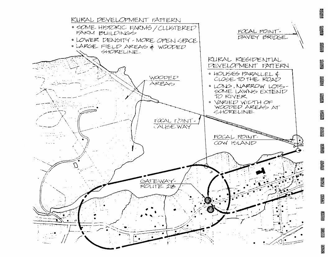
rczi\L. POI NI T-- 17AVS1 r2FZI12SE__
17E-VaL07MENIT" FATIER_I\J o &WE_ 11-0K1C- PAKI\4e GLL12-5FEP----E1)
rAfzkir t,t_i I LE71 o LOWE4C P - MORE_ Ore-K1 9gAC-e- o LARCor- EL 17 AFe--EA‘ WO9r2E-2
hi-hc2KE L Kie-
\ X
VCU RAL rEl\z-nAL PEVELZ)11•AENIT r-nr EEN o I-10LI6S PARALLEL 4-
LOE.- TO THE- peoAry O Lakr9 KIARROvi
CM LAwm.‘-.7 cx-rm\Jr2 TO RI VE_Pc.
o VARI EIP WI71H OE wwre-17 --_,71-10te-E. ,L
LTALI,SEIWAY
,..,•._ ---- -',_—" ---‘• 2 _ • t--- --- --n i , i ■ •°,:.----,----r-, *..:Y. r" ,,,,----",-------:
ic'•
....-rt - >-,. --. „. 1. • :25..-2<111. -
-7-
N • ---• - ------_ _,-_ ___
•
, ' . , , ta__ • . • ose ma:at
#40.0..........
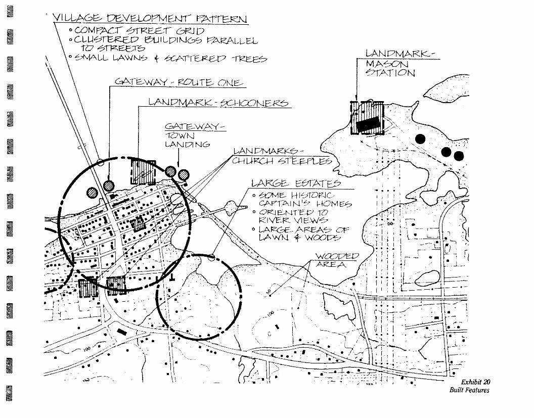
• VI LLACo-- OEVE-LOIA EMT" vArrEiz_n Ocord' rAcr C9R-I o CLI-leTER-E_A7 i1_1 LPI KICPS ALL Et
o hijALL LAWki 4- \TTEiza?
Cab\T-E-WA - ROUTE- 01\1E--
LAK1I7N4AR - tCONEK'S
MAON1 ‘•_,2-1A1 ION
GA-re_wA-{ - -1Vw NJ LA N1171 NG
LAN PINitAfeK&
• &AvIE.- Hiz2.2-10FJC , cper,A H HONI Ex7
o CK1 ID RI \TER ESW.
o LARGE- AR-EA L.Av(Kt 4- woo rx-_,
. • •
\ - •, , „, •
• ••
• •
• \ • •
Exhibit 20 Built Features
vtiorip_47 AREA
..00111,
LANDMARK--
1 1 1 1 1 1 1 1 1 1 1 1 1 1
Exhibit 21 Hesper and Luther Little Schooners
unkempt vegetation on either side o Route One do
not provide a positive sense of arrival and welcome to
complement the high visual character of the village
center.
The Town Landing provides another major gateway to
the village center for recreational and commercial
boats that approach the Town from the Sheepscot
River. This gateway lacks clear visual definition and
needs further articulation to establish a strong iden-
tity.
The third, and final gateway into the village is along
Route 218 at the area of the Old Jail House. This area
begins a pleasant arrival sequence that transitions
from the rural, open areas on the outskirts of town
through a moderately developed area, that terminates
in the village center. This sequence is very successful
as it is.
Materials - Early construction of the village was usu-
ally wood clad or brick. In areas where earlier architec-
ture remains, wood, brick and stone continue to be the
dominate building material.
VISUAL CHARACTER SUMMARY
Together, the historic, natural and built features combine
to create the visual image of a traditional coastal New Eng-
land village in a rural setting. The combination of the
elements described above create a number of unique visual
images along the shoreline. The differences and similari-
ties among these visual images and their location has led to
the classification of the riverfront into four distinct visual
character areas presented in this study.
The Clark's Creek Area is characterized by the configura-
tion of the shoreline, the moderately to steeply sloping
banks, and the visual contrast between mature trees and
open farm fields which create a high degree of visual
enclosure and strong visual interest
The visual character of the Clark's Creek Area is a mixture
of significant areas of undisturbed woodland interspersed
by a limited number of open fields and single family
residences along it's shoreline. Along the south slope of
Clark's Point steeply sloping,wooded banks descend sharply
down to a rocky, cobble shore with pronounced ledges that
extend into the cove. This area offers a number of pano-
40
1 1 1 1 1 1 1 1 1 1 1 1 1 1
ramic views across the Sheepscot River to Edgecomb, and
across the cove to the Village Center. At the mouth of
Clark's Creek the visual setting is much more intimate and
the view is much more defined. On the eastern shore of the
Creek heavily wooded banks descend sharply onto projec-
tions of ledge that slope into the water. Mature hemlock
and pine lean out from these banks towering over the
water, reinforcing the enclosed cove and directing views
along the channel of the creek. On the western shore of the
creek mature woodlands of pine and oak begin to give way
to working farms and single family residences towards
town. The land is gently rolling with several small streams
and swales traversing open fields and remnant pockets of
woodland. The views become much more open as you
proceed south toward the Village Center. Mature pine and
red oak line the shore over emergent grasses. The aban-
doned narrow gage rail bed forms a linear landform that
parallels the western shore, at times merging with the
natural shoreline and at times forming an isolated white
spine defined by it's rubble ballast base.
Views into and from the Clark's Creek cove of the undevel-
oped wooded shoreline, with a few scattered houses and
farm fields are what helps create the image of the small
village center with a defined edge surrounded by rural land.
The visual character of the Village Waterfront can be
defined as a contrast between physical development and
natural features. Along the northern edge, the visual
character of this area forms a transition from the rural
open fields and remnant pockets of woodland into a more
structured form of residential development around the
small cove north of the village center. This area is defined
by single family homes, set back from the shoreline by
areas of lawn which sweep down to a naturalized edge
along the western shoreline of the Sheepscot River. The
houses that wrap around the cove, create an inwardly
focused, intimate visual setting. This setting is in sharp
contrast with the railroad causeway and the gravel parking
lot just east and south of the cove. Although these latter
areas are not particularly visually pleasing, they do provide
a number of vantage points for open, panoramic views out
over the Sheepscot River and up toward the Village Center.
The visual character along the village waterfront, although
completely urban in character, is comprised of similar
contrasts. This area, a relatively narrow strip of land
directly adjacent to the village center, offers panoramic
views out over the Sheepscot River and Village Harbor.
However, taken by itself, it is a relatively barren area
lacking in any substantial visual appeal. Views from the
Town Landing are panoramic out over the Village Harbor
and the Sheepscot River. Again, however, there is little
visual connection made between the Town Landing and
the village center. The historic, intimate and pedestrian
scale of buildings and streets in the village center does not
extend down to the village waterfront edge. The lack of
vegetation along the village edge also contributes to its
somewhat negative visual character. In addition to these
elements, the historic ship wrecks, just offshore, provide a
counterpoint of historic interest that speaks of pictur-
esque abandonment and maritime history. Above the
immediate shoreline edge at the village Center exists the
41
composite of narrow streets, historic buildings and pleas-
ant pedestrian character that gives Wiscasset its reputa-
tion as the "prettiest village in Maine".
This sense of separation between the village waterfront and
the village center is further reinforced by the fact that
several of the waterfront businesses orient toward the
town center along Federal Street and away from the waterfront.
This area, with the cornpact village center and clear transi-
tion to village residential and rural surroundings, contains
the essence of the visual character which is valued by the
residents of Wiscasset.
The Village Harbor Area is an area of diverse land uses and
contrasting visual character which are brought into close
visual relationship because of their location around the
sloping shoreline of the Harbor, Pottle Cove and Hilton
Cove. The enclosed configuration of the harbor creates a
visual character that is defined by the diverse land uses
along its rim.
The character of the shoreline south of the village center is
moderately to heavily wooded, with views to several large
and visually prominent residential estates. This wooded
and residential shoreline character dominates the north-
ern portion of the area.
The visual character of the southern shore is visually
dominated by a clear cut that accommodates high voltage
power lines which run westward from the Mason Station.
The lack of vegetation within this utility right-of-way is a
severe visual intrusion upon the otherwise pastoral land-
scape. This condition presents the only truly negative
visual impact within this character area.
The building mass and industrial character of the Mason
Station at the southeast terminus of the harbor, provides
an interesting counterpoint to the visual character of the
historic village across the harbor, the wooded residential
character along the western rim of the harbor, and the
more natural appearing landscape south of the power
plant. In addition to these areas, there exists, an historic
mill pond formed by the damming of Ward Brook before it
enters Hilton Cove. This particular area has a park-like
landscape character which offers views across the harbor
to the village and the Mason Station. This Area, with its
visual diversity, enclosed configuration and continued use
as a boating and mooring area, is important to the visual
quality of the riverfront. The northern, wooded portion of
the harbor shoreline also provides the southern "visual
boundary" of the historical village center.
The visual character within the Back River Area is rugged
and heavily wooded. The slopes of Cushman Hill descend
steeply into Cushman Cove and the Cowseagan Narrows
down rocky bluffs and onto cobble shores. The steeply
sloping terrain offers spectacular views across Cushman
Cove and the Cowseagan Narrows to Westport. This area is
totally undeveloped and provides a rugged beauty that
contrasts sharply with the developed visual character of
the Village Center. The shores of Cushman Point retain
the same rugged character although this peninsula has
42
1 1 1 1 1 1 1 1 1 1 1 1 1
been subdivided into single-family residential housing
lots. From the house lots and access road, the dense
woodlands offer only an occasional filtered view out over the water.
It should be noted that this area is highly sensitive to visual
impact because of its steep slopes and visually prominent
ridge line. Goals for the preservation of existing visual
quality and the inherently sensitive quality of this area
should be carefully evaluated before change and growth
occur in this area.
HABITAT
(Exhibit 22)
Upland Habitat Within the Riverfront Study Area the Sheepscot and Back
River corridors contain a diverse array of high quality wildlife habitat
Clark's Creek Coveand the adjacent portion of the Sheepscot
River are classified as a Class "C" coastal wildlife concen-
tration area by the Inland Fish and Wildlife (IF&W). Areas
with a Class "C" rating are significant because of the
abundance and diversity of wildlife they support, and their
importance to rare species. The rating system used by the
IF&W is a three tier system based on the value of coastal
wildlife relative to other areas that are rated within the
State, as well as, the relative abundance and diversity of
species a particular area supports. A Class "C" rating is
significant at a local level and is defined as an area with
moderate species abundance or diversity.
(see appendix for definitions).
The relatively steep, south-facing slopes of the upland area
located between Clark's Point and the mouth of Clark's
Creek are dominated with a forest cover primarily com-
posed of a mixture of white pine (Pinus strobus) and red oak (Quercusrubra). Much of this area has reverted back
from former agricultural uses to distinct patches of paper
birch and aspen woodland on the hillsides. Remnants of
old orchards are apparent from stands of existing Apple trees (Pyrus malus) that are scattered along the hillside. Hemlock (Tsuga canadensis)and white pine dominate the wooded area immediately along the eastern shore of Clark's
Creek. Deer are often observed within these forested areas
because of the cover and the food source they provide. A
deeryard, located to the northwest of Clark's Creek, has
been rated by Inland Fish and Wildl ife as having a high (D3)
value. A second deeryard immediately north of Clark's
Point has received a moderate rating of (D2).
Bald eagles (Haliaeetus leucephalus)were observed roost-ing in the pines near Clark's Point on several occasions and
feeding along the shoreline of the cove. Although no active
nests are known to exist within the survey area, eagles
often frequent open water areas, particularly during the
winter months when they concentrate along the unfrozen, tidal waterways.
Scattered residential development has fragmented much
of the natural character of the shoreline south of the
Clark's Point Road Bridge. Most of this development has
occurred immediately, alongside Route 218 and has not
43

I K16
EmarcoEKIT VEEE1Ai ION AAAE-1--
M HP FLA-10M
WOK m ANAKVE- 51 -I 116 A R2 f-A
Ee-YF I NAG t-
r-tr- WI r\flgI INr." YA K[7
PAVE-t E5C
f1/4A.A.,fAfikj 171-APO N
Cfc.r.AE-1‹. _ VI LLAcE-
WATERT= RoA4A
17EF117-: . •. W I Il -rEAc.1
OPE NA
FEf \ixo\-1-EK HeAetil
E.TUNP, .;ILL:Arv1 CR F, WE
NelEsrEoRT V-40-1 Ptce
E--,N1E- i-T,T;E: K11 VEkr-E ■ EN-1 101\1
NI ar 7 V-071 CLi
ET-A( ECVE R-
CLA rEre-F2=f
Exhibit 22 Existing Habitat
directly impacted the rivers edge. Several existing hay
fields extend from behind the roadside homes to a narrow
strip of red oak and white pine that still remain along the
shoreline. Some portions of the southern end of this
section, however, contain extensive shoreline stands of
oak and pine that provide food and habitat cover for a
variety of animals that frequent the area (see appendix I)
Development within the Village WaterfrontArea has had a
marked influence on the quality and type of natural habitat
found within this area. The development pattern within
this study area transitions from an open, rural-residential
land use pattern with open yards and fields and wooded
shoreline north of the village center, to the more urban
character and intense development pattern associated
with the village center.
North of the village center one finds a mix of hardwood
stands, open fields and several perennial streams that flow
into the Sheepscot River. South of the Middle School the
shoreline area begins to become more intensely developed
with the Wiscasset municipal sewage treatment plant
located on Cow Island, the Town Landing, and accessways
to both the southern end of the Maine Central Railroad
causeway and the Davey Bridge across the Sheepscot River
dominating the waterfront. Existing trees and shrubs in
this area are limited to what is found within private yards
and undeveloped portions of properties.
South of the treatment plant, along the waterfront to the
base of Pleasant Street, little natural habitat remains to
support any significant level of bio-diversity within this
area. Remnant pieces of land are all that is left of what was
once a wooded shoreline. The development of the water-
front along this section of shoreline has reduced the ability
of this area to support any significant wildlife to the point
where the Department of Environmental Protection has
classified this area as non-redeemable.
This ecozone is predominantly affected by the high degree
of adjacent land use, the general water quality of the
Sheepscot River and the level of tidal flushing through the
railroad causeway located north of the treatment plant and
immediately south of the Town Landing.
Within the Village Harbor Area, the IF&W has identified
the Hilton Cove area as a Class "C" coastal wildlife concen-
tration area. The area is defined as an area with moderate
species abundance or diversity.
The southern edge of Pottle Cove is overshadowed by an
extensive power line right-of-way extending northwest
from Central Maine Power's (CMP) Mason Station located
on Birch Point. Because of the placement of the power
lines, patches of pine and oak are relatively small and
scattered along the steep, north-facing shorefront of Pottle
Cove. A shallow, relatively undisturbed tidal pond, ap-
proximately two acres in size, is located adjacent to the
western shoreline of Pottle Cove, northwest of the railroad
track. This pond is dominated by cord grass.
Ward Brook drains through an emergent freshwater marsh,
northwest of Birch Point Road, into a freshwater pond
located at the southwest end of Hilton Cove. The pond was
46
1 1 1 1
1 1 1 1
1 1 1
created by the damming of Ward Brook on ledge outcrops
located along the edge of the tidal cove. Water levels in the
pond and upstream marsh are regulated by this structure.
A small stand of cottonwood (Populus deltoides) is located
north of the pond. The pond itself is primarily surrounded
by maintained lawns extending along the entry drive to the
Mason Station.
Birch Point forms the eastern boundary of Hilton Cove.
Present natural features of the Point have been heavily
influenced by continued development of this Point for
commercial use. Today it is dominated by the Mason
Station, an electric generating plant. A stand of paper
birch skirts the Power Station along the southern end of
Hilton Cove, while several small stands of aspen and pine
are scattered along the shoreline edges of the Point. An
osprey (Pandion halketus) nest was located within the Hilton Cove area.
Within the Back River Area, IF&W has identified Cushman
Cove as a Class "B" coastal wildlife concentration area. This
is a regionally significant area of the Maine coast. Class "B"
areas are defined as areas with high species abundance or
diversity, or areas of importance to a State listed Special
Concern, Indeterminate Status, or Watch List species.
This area is relatively undeveloped and characterized by
steep, east-facing slopes predominately forested with white
pine/red oak/sugar maple forest cover association. Hem-
lock, red oak and several miscellaneous hardwood and
softwood species are scattered throughout the shoreline
slopes. The area between Cushman Cove and Birch Point
Road north of Route 144 (Westport Island Road) is domi-
nated by the forested slopes of Cushman Hill. The north-
west facing slope of Cushman Hill is more gradually sloped
than the steeper, eastern side. Paper birch and other mixed
hardwoods dominate the upper slopes, while white pine
and red maple (Acer rubrurn) domi nate the lower portions.
A wetland dominated by red maple is located along the
bottom of the hill. The area of Cushman Hill includes a
fairly extensive deer yard that has been mapped and identi-
fied by IF&W. The exact extent and value of the deer yard
habitat is not known at this time and will require further
study by IF&W.
South of the Westport Island Road lies another fairly
extensive wooded area. The immediate shoreline slopes
are steep and predominantly covered with white pine,
while the more inland areas are dominated by a mixture of
white pine, red oak, trembling aspen, paper birch, with
scatterings of balsam fir (Abies balsarnea), red spruce (picea rubens), and hemlock. A second mapped deer yard
extends south to Ferry Road. The extent and value of the
habitat within this deeryard will require further evaluation
by IF&W. A public boat launching site of limited size is
located at the Ferry Landing site.
This ecozone is predominantly affected by the topography
of the shoreline area, absence of development, and the
general water quality of the Sheepscot River.
The area between the Mason Power Station and the Old
Ferry Landing is relatively undeveloped and characterized
by steep, east-facing shoreline slopes and pine/oak forest.
47

The steep, rocky slopes have prevented easy, direct access to the shore and thus, the subsequent development of the shoreline area. Appropriate multiple-use management of the forest resources will provide the critical support neces-sary to maintain local wildlife, timber and recreational resources. Proper management of the wooded slopes will also maintain and enhance the existing aesthetic quality of the Town.
Marine Habitat Marine resources encountered within the study area are fairly common in this part of Maine and provide an impor-tant economical asset to the Town. Maintaining the health of significant marine habitat areas is important to the character and livelyhood of Wiscasset.
The natural features within the Clark's Creek Area are strongly influenced by the water quality of Clark's Creek and the many perennial streams that enter the Sheepscot River. A causeway and bridge, constructed by the Maine Central Railroad extends approximately 4500 feet across the mouth of Clark's Creek Cove from Cow Island to the southern tip of Clark's Point. Tidal flow within the cove area has been restricted to an approximately 1100 foot gap in the earthen and rock causeway. This limited opening has reduced the ability of this area to properly flush itself of sediment and nutrient runoff from adjacent shores.
Shoreline flats within this character area provide habitat for marine worms that have been traditionally harvested by local fishermen. The immediate intertidal zone is pri-marily rocky with patches of bladder wrack (Fuscus vesicu-
losus) and knotted wrack (Ascophyllum nodosum) often found washed up on the rocks. Cordgrass (Spartina alter-nillora) is located in small patches immediately along the shoreline south of the Clark's Creek outlet. Black ducks (Anas rubripes) were noted to regularly feed within the stri ps of emergent vegetation immediately along the shore, while red-breasted mergansers (Mergus serrator), white-winged scoters (Melanitta &sal), pintails (Anus acuta), common goldeneyes (Buceplzala clangula) and buffle-heads (B. albeola) were often noted further offshore in the cove and river.
Despite periodic closings of the local mudflats, the marine resources of Wiscasset and the Sheepscot River are gener-ally regarded as exceptionally clean and healthy. This is directly influenced by the lack of upstream industry. Wa-ter quality within the Sheepscot River drainage has a sig-nificant effect on the entire Wiscasset shoreline, and the continued well-being of those dependent on the utilization of these finite natural resources. Maintaining the quality of this resource base is dependent upon the level and support for the prudent regulation of point and non-point pollution sources within the Sheepscot River watershed.
Within the Village Waterfront Area development along the shore has had a marked influence on the qualityand type of wildlife and habitat found from the treatment facility causeway southward to the Town Landing, as well as, the tidal areas situated between the railroad causeway and the shore west of the Town Landing.
Mudflats, traditionally used by local fisherman as worm-
43
harvesting areas, continue to extend from the Clark's
Creek Estuary, southward, along the shoreline to an area
immediately south of the Edgecomb Bridge. The produc-
tivity of these flats has been diminished over time because
of persistent runoff and changes in the water chemistry in
this area. Joppa cove, approximately 430 feet across, di-
rectly west of the treatment plant is domi nated by mu dflats
with patches of cordgrass along the outer edges. Siltation
of this cove has occurred rapidly over the last several years
due to a large volume of sediment runoff from sites
upstream. A narrow strip of cattails (Typha angustilblia) now exists along the southern edge of the cove. Along the
cove's western edge a small perennial stream traverses
through several private yards before emptying into it. The
cove area currently provides regular roosting habitat for herringgulls (Larusargentatus), black backed gulls (Larus marinus), and ringed-billed gulls (Larus delwarensis).
West of Whites Island, the causeway on which the former
Maine Central Rail line runs, extends approximately 2000
feet from an area just south of the Town Landing to a point
north of Pottle Cove. The extension of the railroad cause-
way across the harbor creates a protected tidal area situ-
ated between the causeway and the shore. Tidal flows in
this area are severely restricted due to the earthen and rock
causeway. Access to White Island can be gained by travers-
ing a wooden bridge to the island from the railroad cause-
way.
This tidal area contains the remaining evidence of former
piers and wharves. Salt marsh grass (Spartina patens) has become established on the remnants of these former
structures. Cordgrass is located throughout much of the
remainder of the tidal wetland. Large areas of red oak and
white pine ring the western edge of the tidal flats and
extend upland along two perennial streams that drain the
east-facing slope of the village shoreland.
Black ducks were noted to regularly feed within these areas
of emergent vegetation located immediately along the
shoreline, while mallards (Anusplatyrlzynchos), red-breasted mergansers, white-winged scoters, common goldeneyes
and buffleheads were regularly observed both in the cove
and river areas.
Development within the Village Waterfront Area provides
both positive and negative planning attributes. The level of
development has significantly reduced the biological di-
versity of the shoreline edge and it's ability to regenerate
quality wildlife habitat. On the other hand, it offers easy
access to the shoreline providing a unique opportunity for
both year-round residents and seasonal guests to appreci-
ate and enjoy the unique natural features of the Town. The
tidal river and shoreline is a natural centerpiece for the
town to use in providing any number of passive recrea-
tional uses that would directly benefit many of the local
citizens and businesses. In addition, there exists a number
of locally original and distinctive educational opportuni-
ties involving the numerous and readily accessible, natural
and historic features of Wiscasset. The proximity of the
shoreline mudflats to the Middle School provides a unique
and ready-made laboratory which could allow many young
students the ability to develop a better appreciation for
both the ecology of the tidal waters and the history of Wiscasset.
49
In the Village Harbor Area it is not uncommon for black ducks to regularly feed within the narrow strips of emer-gent vegetation located immediately along the shoreline, whilered-breastedmergansers,white-wingedscoters,common goldeneyes, and buffieheads were regularly observed both in the coves and river. Common Loons (Gavia immer) were often noted well into the central portions of the river. A narrow, sheltered cove extends approximately 2000 feet along the southern edge of Birch Point. No direct public access by land to this tidal cove is available, providing feeding opportunities with limited disturbance for mal-lards, red-breasted mergansers,white-wingedscoters,common goldeneyes and buffleheads.
The quality of the marine resources within this area is pre-dominantly affected by the adjacent land use, and the general water quality of the Sheepscot River.
Within the Back River Area, Cushman Point is a narrow, relatively steeply-sloped peninsula of land extending from, and running parallel to, the main Wiscasset shoreline. The Westport Bridge crosses the Cowseagan Narrows to West-port Island across the southern end of Cushman Point. Cushman Cove is a long, narrow body of water, approxi-mately 3400 feet long, that separates the majority of Cushman Point from the mainland. The narrow cove is approximately 1000 feet across at its widest point. Devel-opment of the shoreline area has been hampered by the extreme steepness of the surrounding shoreline. Much of this tidal area is too deep to accommodate emergent vegetation. The cove provides feeding opportunities with
limited disturbance for red-breasted mergansers, white-winged scoters, common goldeneyes and buffleheads. Emergent vegetation is more available within the small cove that is enclosed by the southern end of Cushman Point, and is located immediately south of the Westport Island Road. Black ducks and mallards were noted to feed along this section of shoreline.
50
1 1 1
1 1 1
1 1 1 1 1 1
ANALYSIS
PUBLIC ACCESS
The Comprehensive Plan clearly states that "...ample park-
ing and ready access to and from the Sheepscot River" is
a goal that the Town wishes to achieve as part of it's growth
management objectives. With over nine miles of shoreline
along the Sheepscot and Back Rivers such a goal would
appear to be easily met. Traditionally, local fishermen,
wormers, boaters and residents have accessed the water-
front at such public facilities as the Town and Old Ferry
Landings and from several private properties where land-
owners have not objected to local access. However, in-
creases in recreational boating, residential development
and the number of tourists over the last five years has
brought a proportional increase in the demand for access
to the water. This has begun to exceed the capability of
existing facilities and the willingness of neighbors to allow
free access across their property. Conflicts have occurred
frequently between visitors and residents for limited ac-
cess to the waterfront.
Through the study of the riverfront area and conversations
with town residents, the Design Team has identified a
number of physical, institutional and psychological barri-
ers which currently inhibit access and enjoyment of the
riverfront:
Physical Barriers - Physical barriers are generally
considered to be the most imposing in restricting
access. Such barriers generally include bridges, high-
ways and railroad lines. These types of infrastructure
improvements along the riverfront make it easy to get
near the shoreline but difficult to actually reach it.
Wiscasset's riverfront has a number of such physical
barriers along it's shoreline.
Institutional Barriers - This type of barrier occurs
where physical access is possible but is not allowed be-
cause of obstacles created by legal, political or eco-
nomic conditions. Institutional barriers generally
include: utility plants, waste water treatment facilities
and military facilities. The private ownership of prop-
erty can also be considered an institutional barrier.
Institutional barriers tend to be exclusionary or self-
contained, and depending on their use may hinder or
preclude access to the water all together.
PsychologicalBarriers- This barrier often stems from
impressions of the riverfront's accessibility, safety,
users and general activities associated with areas of the
riverfront.
Several of these "barriers" have existed as part of the
character of the riverfront but were never considered to be
barriers to water access by local residents. However,
because of changes in either their use or an increase in
demand, a number of these physical elements currently
pose impediments to citizen access and enjoyment of the
riverfront.
51
'->NEORMIA,1_, WALKING KOUTE A101.4C, RAI L- - COQ FLICT WtIW rgA4N
INFOI<MAL_ RPCP:EATIONAL, LlhE., M 001- MRCE.1.-
rcu-rE ONE- - V -Ileoh■ rlenViC VOLUIAE- 114FWE), rEIWKIA.AI Cg0564 NS
C-r-E.A.METCY
rt. E-NTI AL PF_ATIZIAM cokiLicr, wrn-k TwAtKi AT- t-OWN 0 ■AAJ LP WATER
se_m00,Na.ks
stno.s usnoit.c. - e1 TE.. LAYOUT - CHARACSEg- Auto CEJEJ■irer
CLL.
OWNFr-*.m-ti---0; -WAY 4 PT_Cr.611KIAm 4tr_t.
VIC ivAT- E-U■ OWNEr
LACK OP rat:- WAVER, $ti-p,..? 4 HAW-WK.
AKEA
mAsoui etAl-K,s4
=cr. rt
nz,..„-
Exhibit 23 Barriers to Pedistrian Access
52
1 1
1 1
1
1
Pedestrian (Exhibit 23)
The most impacted by these barriers is the pedestrian movement along and access to the riverfront. Several physical, institutional and psychological barriers exist along the riverfront that impede pedestrian access and enjoyment. These barriers either deter or directly limit the access to areas along the riverfront.
The physical barriers found along the riverfront that impede pedestrian access are:
Route One Highway and Bridge - The abutment for the Davey Bridge creates a physical barrier for pedestrian movement traveling in a north-south direction along the village waterfront Adequate clearance for pedes-trians does not exist between the base of the bridge span and the elevation of the shoreline to allow people to travel along the riverfront without crossing Route One at grade. Traffic on Route One has more than doubled since 1980, and is particularly heavy during the summer months. This inhibits easy crossing for people trying to access either side of the village water-front. Traffic volumes are expected to continue to increase in the region, along with the demand for tourism and recreation.
The establishment of a separate grade crossing for pe-destrians and vehicles would be the most efficient solution to reduce the conflicts between pedestrian and vehicular movement across Route One. However,
1 1 1 1 1 1
1 1 1 1 1 1 1
because of costs, shoreline configuration and the
concern for personal safety, the development of such a
crossing is prohibitive. An at grade solution, either
through proper traffic signals or the crossing guard
currently used, appears to be the most feasible solution
at this time.
MOOT Rail Line - Since it's abandonment in 1979, pe-
destrian movement along and across the rail line has
become commonplace. Concerns for pedestrian/rail
conflicts and the issue of liability could significantly
reduce pedestrian access to the water if physical barri-
ers, such as chain link fencing, are erected. Discus-
sions with Massachusetts Central Railroad have in-
dicted that they do not intend to erect any type of
barriers along the rail right-of-way at this time.
The rail causeways from Cow's Island to the southern
tip of Clark's Point, and from White's Island to the
shoreline of the village harbor are currently traversed
by pedestrians wishing to access either shore from the
village waterfront. These access opportunities will be
curtailed with the reactivation of the rail line.
More random pedestrian crossings of the MDOT rail
line frequently occur around the Yacht Club, the Town
Landing, the Creamery Site, and along the tracks
between the Town Landing and the Creamery Site.
This free movement is not expected to be curtailed by
the projected one train trip per day. If the number of
daily rail trips increases substantially, every effort
should be made to assure that pedestrian access to the
waterfront is maintained.
Because of sight-line concerns at the town landing, pe-
destrian access to the landing from the parking area
above the landing off Water Street should be controlled
by the use of planned access points across the railroad
tracks.
Rocky Blida I Steep Slopes - The shoreline of Wiscas-
set has several areas of steep slopes and rocky bluffs
that impede physical access to the water. These areas
are particularly prevalent in the area of Cushman Cove
and around Clark's Creek. Although such natural land
configurations obstruct physical access, they do offer
spectacular view points for visual access along the
ridge and from the water. Such areas should be
respected and physical access to the water from the
land side not encouraged.
Several institutional barriers also exist which impede
pedestrian access to the water. Those are:
Property Ownership Patterns - The lack of publicly
owned property along some sections of the riverfront
is a significant institutional barrier to public access.
The majority of town owned lands that provide public
access to the water are located along the village water-
front. A limited number of opportunities for public
access exist north and south of the village center. The
concentration of town owned land in the village center
is due to an historical pattern of land ownership estab-
lished as the town developed and provided public
53

services for it's residents.
The benefit of such a pattern is that clustering of public access sites in the village waterfront reinforces the historic land use pattern of the town. This reinforces the village center as the focus of the town, and helps maintain the rural character that currently surrounds it by removing development pressures for water access from the areas of Clark's Creek, the Village Harbor and the Back River. This has helped preserve the image of a traditional historical village within a rural setting that the town wishes to maintain.
Conversely, by having the majority of access points clustered in this fashion, the result has been that an increase in the demand for water access has overrun the ability of these facilities to accommodate the demand for parking and vehicular access. Efforts to accommodate these needs, by increasing parking and improving streets, has resulted in diminishing the pedestrian orientation at these sites along the water-front. Very little pedestrian amenity, such as benches or trash receptacles exists, and in places adequate pedestrian linkages are lacking. Excess demand for water access- primarily boat launching - should be ac-commodated by the development of other sites either within the village center or at another location in order to reduce the congestion and demand for the facilities in town.
Waste Water Treatment Plant - Access to the shore- line around Cow's Island is physically possible but is
restricted because the waste water treatment plant occupies this site. This site provides a number of good vantage points for viewing the village, Clark's Point and the surrounding views across the river, and is relatively secluded. The existing physical conditions currently discourage access to this area because of fencing and occasional odors. The facility will be expanded in the early 1990's. Improving public access to this section of shoreline is not considered by towns-people to be essential to their enjoyment of the waterfront.
Mason Station - Access to the shoreline around the Mason Station is physically possible but is restricted because of issues of liability and the activities that occur there. Unlike Cow's Island, access to Birch point is much more significant because of its deepwater pier and the opportunity to relieve some of the boating congestion and associated parking problems at the area of the Town Landing. An opportunity exists for the Town to discuss with CMP the possibility of achiev-ing water access for recreational boating as part of CMP's plans to improve the facility for the shipping of cement products. If a boat launch area is developed on CMP property, the opportunity would also exist to extend pedestrian access to this location on the har-bor.
Psychological barriers also exist along the riverfront, which cause town residents to avoid using certain areas even when the opportunity exists. Discussions with several residents have pointed out the following perceptions about
54
.9t-Ablv
•miksowiAL. 1-004. ricAtpic VOL.LIME. ON Korn. ONIEL-1MrFae, afa"),,Ne firdISFIC-
VeFilCULAR conaicrs wril4 -Maki WILL. c.AUX, Fr-44021C-
N TILTAFFC FLOW Ar , KCieeSeiwicrea
IrOutE CNE. - te•e01,4AL HIG4-1 rickpFtC ‘ACLume-
N-*° ecr 7-r-rr
-SF-AtiCCIAL- 1 ,21gKING .SHOKTPthe_ INC.Eatee. -ficAnic- FLOW COKICenal
LAI,4171iNi&
frcHt aties
Wurrt.' ozt.A.Np-
Exhibit 24 Barriers to Vehicular Access
55
1 1 1
1 1 1 1 1 1 1 1 1 1
the riverfront
I The village waterfront is a place residents would not
visit at night because of the groups of young adults that
congregate at the town landing, as well as other areas
along the waterfront.
I If access along the riverfront is expanded for residents'
enjoyment, it will eventually be over used by tourists
and local young adults.
Psychological impediments can only be totally removed by
educating the public about the amenities to be found along
the waterfront. The active participation of local law en-
forcement and residents working together will help en-
sure that the proper use of the riverfront occurs. The
riverfront is a local resource the community need not give
up the use to other groups on the assumption that im-
provements to the waterfront will encourage undesirable
activities to occur. Such activities can be eliminated or
deterred through proper design, planning and most of all,
community involvement in the development and mainte-
nance of the riverfront
Vehicular (Exhibit 24)
A number of physical barriers exist along the riverfront
that impede vehicular access. These barriers are:
Route One - The volume of seasonal traffic on Route
One reduces the ability of vehicles traveling along the
side streets within the village center to access Route
One, as well as other parts of the village center. Proper
traffic signalizing at one or more intersections in the
village center to allow adequate traffic flow from side
streets appears to be the best option at the present
time. This type of solution could improve both ve-
hicular and pedestrian traffic flow problems in the
village and along the village waterfront.
MDOT Rail Line - The reactivation of the rail line is
expected to bring no more than two rail trains through
town per day (one round trip). Traffic flow along
Route One will be stopped during each train passage.
The effects of this will be to create a periodic increase
in traffic congestion along Route One and the village
side streets. Periodic delays will also occur at the
access drive to the Town Landing and Yacht Club. The
initial number of trai ns passing through town, and the
initial length of these trains is expected to have a
minor effect on the seasonal traffic flow along Route
One and vehicular access to the waterfront (conversa-
tion with MDOT). However, if the number of trains
and the length of trains increases over time, the effect
on the town will become more pronounced.
Parking
Inability to park close to the riverfront serves as a physical
barrier for people who depend upon motorized vehicles for
mobility. This is particularly true for the elderly and the
handicapped, as well as for people who live outside the
town and desire access to the riverfront. The Comprehen-
sive Plan states that adequate parking for public buildings
and river access sites is an objective of their growth
management policy. Parking north and south of the
village center is easily accommodated on individual lots,
which is traditional of the land use pattern found in these
areas. Land parcels north and south of the village center
average in size from five to fifteen acres, with several
parcels of twenty acres or more. Should future facilities for
water access north or south of the village center be desired,
there is ample land available to provide adequate parking,
at present time. To assure public access in the future, the
Town may consider the purchase of a parcle.
Parking needs within the village center are accommodated
by a number of small lots with five to fifteen spaces tucked
in between buildings, and by a number of on-street parking
spaces along several of the side streets. This system has
worked well in keeping a balance between providing park-
ing and maintaining the pedestrian and historic character
of the village center. This existing, historic development
pattern within the village center was established at a time
when transportation needs were satisfied either by foot or
by horse. Consequently, buildings were clustered tightly
together in response to a slower more laborious mode of
transportation. Today, this historic development pattern
provides a scale and historic charm in the village that town
residents wish to maintain. This type of development
pattern, because of the inherent lack of available sites
suitable for the creation of additional parking, precludes
the development of an adequate number of parking spaces
that would efficiently meet current and seasonal demands.
The availability of parking within the village center is
inadequate to meet the demand during the summer and
56
1 1 1 1 1 1 1 1 1 1 1 1 1 1
fall months. The lack of parking spaces in the village center
has also hindered many existing businesses from using the
upper floors of their buildings because of an inadequate
number of spaces to satisfy existing zoning standards. The
lack of adequate parking is further complicated by:
Insufficient parking for boat trailers which use the
Town Landing. Often these trailers are found parked
along the side streets close to the Town Landing,
occupying one or more parking spaces.
• Random layout of some parking areas within the
village center. A properly designed layout of these lots
could increase the number of parking spaces.
I Insufficient signage to direct visitors to the closest
parking lot available. Because the lots within the
village center are small and tucked away between
buildings it is difficult for people unfamiliar with the
town to find a parking space. While some may argue
that this result is desirable, it leads to cars travelling
up and down the residential side streets and adding to
the already congested traffic flow. Many park where
they please, simply out of frustration.
To resolve the parking problem within the village center
several have suggested using the open land along the
waterfront for parking or the creation of a satellite lot at
the edge of the village center. To resolve the parking
problem by either, creating large satellite parking lots or
siting parking along the water would diminish the village
character of Wiscasset by disrupting the balance between
vehicular and pedestrian uses.
Any solutions proposed for the resolution of this problem,
should respect the existing development pattern within
the village and the wishes of residents to avoid siting large
parking areas on the waterfront. If additional lots are
created, they should be relatively small in size, fit within
the historic development pattern and be located such that
pedestrian access from them to the village center is fea-
sible.
Railroad
'No rail lines traverse the study area of the Wiscasset
riverfront. The former Wiscasset and Quebec narrow
gauge rail line has been abandoned since 1933. Since it's
abandonment, the condition of the rail bed has been one of
general disrepair. Today it is characterized by areas of
erosion, overgrowth of vegetation, removal of sections of
the bed and the conversion of significant sections to other
land uses (the Middle School ball fields and single-family
residences). Currently, sections of the remaining rail bed
are used for informal recreation access to the shoreline by
local residents. This type of opportunity for informal
access along the river could become more important in the
future if the parcels of land abutting the river are sold and
subdivided. Development of these parcels may result in the
loss of the informal understanding that currently exists
between neighbors which allows for pedestrian access
along the river.
A private group is attempting to purchase the entire length
of the rail bed from the Middle School to the Alna/Wiscas-
set town line for the purpose of restoring rail service along
57
the existing rail bed. It hopes to use the line for light rail passenger and freight service. Given the legal, monetary and physical obstacles that exist to achieving this task it appears that its near term realization is highly unlikely. However, significant support for this endeavor has been expressed at several of the riverfront study workshops. Therefore, the option to pursue this plan should be left open.
The second rail line that traverses the riverfront is the standard gauge line currently owned by MDOT. The Town has stated in it's Comprehensive Plan that the reactivation of the MDOT rail line should be the first priority for use of this line. It also has stated that it wishes that parking and other facilities associated with the reactivation of this line not increase traffic congestion, degrade the environment or have adverse effects on existing neighborhoods.
The Maine Department of Transportation has signed a contract with the Massachusetts Central Railroad to up-grade the line and begin hauling freight in the Autumn of 1990. Discussions have also taken place concerning the feasibility of passenger service along this line for tourists and for workers commuting to Bath Iron Works. The potential effects on the town are many, the most noticeable of those being upon traffic circulation, the riverfront environment and adjacent neighborhoods.
The effect upon traffic circulation will probably be the most noticeable felt by the town. Trains which will pass along the village waterfront must cross two existing major traffic flow routes in town: Route One and the access road
to the Town Landing and Yacht Club. The traffic flow on both routes will be interrupted and delayed by the train as it either arrives or leaves the State Pier at the Mason Station. On Route One this will cause traffic to stack up in both the village center and on the Davey Bridge. Such delays could be substantial during peak flows of vehicular traffic. The full effect of such traffic delays on the Town can not be measured at this time. It can be assumed, however, that increase in traffic congestion caused by train delays will be noticeable, especially during peak vehicular travel times. The Town should negotiate with Massachusetts Central Railroad on issues of scheduling and train length to reduce this effect.
The town could be further affected by traffic congestion if the eight acre site adjacent to the treatment plant is ever developed as a commuter lot for BIW workers taking the train to work. The location of a commuter lot on this site is appealing because of its accessibility to Route One. Conversely, its appeal is tarnished by the fact that traffic circulation in this area is already at capacity. For this reason, MDOT has no plans to use the site for this purpose.
Reactivation of the rail line will have an effect on the environment and wildlife along the riverfront as well, especially at Clark's Point and the Village Harbor area. The serenity of the wildlife habitat in these areas will be disrupted. This is especially true for the Clark's Point area where Osprey, Bald Eagles and a number of coastal ducks have been observed to using the area for feeding, nesting and the rearing of young. Several deer yards are also located in this area and the effect of the train on these yards
58
is unknown at this time. The Village Harbor area, although
already affected by development, also provides substantial
summer and winter habitat for coastal ducks, osprey and
herons. The extent of the effect upon these areas will vary
depending upon the particular type of wildlife and the
number and length of train trips through these areas.
A reactivated rail line can also be expected to have an effect
on the residential and commercial neighborhoods along
the riverfront. Trains passing along the riverfront can be
expected to generate noise, dust and odors from exhaust.
In addition to these sensory impacts, a reduction is also
likely to occur in the random pedestrian access over the
tracks to the water's edge, which is now enjoyed by neigh-
borhood residents. It is unclear at this time what uses may
occur on the MDOT parcel, however, any use of this parcel
for rail related parking or storage of equipment and mate-
rial could diminish the visual quality of the riverfront and
views from some residences to the water.
Visual Access The level of visual access along the riverfront is quite high. Access can be obtained from a number of vantage points
within the village center, along Route 218, from the Route
One Bridge and a number of points along Cushman Point
and the Back River areas. The quality of these views is very
good and their type varies from open, panoramic views
from the waterfront to more filtered views from various
secondary roads. Maintaining a high degree of visual
access along the riverfront is important because it is a type
of access that is available for all residents and visitors to
enjoy regardless of land ownership patterns or other bar-
riers to physical access along the riverfront. Future
development along the riverfront could reduce the ability
to see the riverfront from a number of areas.
HISTORIC AND VISUAL CHARACTER
Historic Character The urban context of a waterfront is partly determined by
its heritage. In light of the fundamental role the navigable
waters of the Sheepscot River played in the development of
the town of Wiscasset it comes as no surprise that many of
it's rich resources of historical and cultural significance
are located along the Village Waterfront. The type and
importance of these resources varies depending on their
age and location. Some of the more well known historical sites are:
Study Area Historical Sites
Clark's Creek
Sutter Dam (ME 491-01) Wiscasset and Quebec Rail Line
Village Waterfront
Kingsbury Shipyard (ME 491-11) Old Jail House
WQR Round House Site Hesper Schooner Luther Little Schooner Wiscasset and Quebec Rail Line
Wiscasset Harbor
Capt. Williamson House Site (ME 491-19) Williamson's Mill Site (ME 491-05)
Back Cove
Bailey Site (ME 491-18)
59
These historical and cultural resources enhance the use
and enjoyment of the riverfront by providing a unique
element of community identity and civic pride. Depending
on the historic designation, ownership and condition of
these and other historic sites, the heritage of the water-
front can either produce many opportunities or prohibit
the use of sections of the riverfront altogether.
The Comprehensive Plan states a strong intent to protect
the town's appearance as a small New England coastal
community with historic architecture and abundant open
space. Of particular importance is the protection of the
"impression of a historic rural way of life". Many who refer
to Wiscasset's historic character, scale and elegance often
give credit to specific historic sites and buildings as impor-
tant references to Wiscasset's heritage, while overlooking
one of the important cornerstones of Wiscasset's historical
character and charm - it's historic development pattern.
The historic development pattern is what provides the
village center with that feeling of pedestrian scale, dra-
matic views down narrow streets to the Harbor and
Sheepscot River, and the small town atmosphere that
everyone enjoys. It is the spatial relationships of building
to building, buildings to roads and buildings to the river,
that people first see, experience and subsequently identify
as the elegance, scale and neighborliness of Wiscasset.
These relationships form the basis for describing Wiscas-
set as that small New England coastal community sur-
rounded by abundant open space. The traditional rural
setting for the coastal village is directly related to the
spatial relationships that Wiscasset's historical land use
pattern has established over the years.
The spacial qualities formed by Wiscasset's historic devel-
opment pattern has created a rhythm between open space,
woodlots and buildings that are difficult to regulate or rec-
reate under standard zoning policies. The influence that
the historic development pattern has on the appearance of
Wiscasset is especially evident along the shoreline between
Clark's Point and Birch Point. In this area, the historic
development pattern is clearly expressed as the compact
village center surrounded by residential neighborhoods
which blend into a rural landscape. One can clearly see the
closely spaced buildings of the village, the ship captains'
homes with sweeping lawns to the waters edge and the
agrarian quilt of farmstead, open field and woodlots that
collectively creates the image of the rural New England
coastal village the Town wishes to protect. However, the
concerns for parking, building setbacks and road stan-
dards, which dominate the development process today, no
longer produces this type of rural development pattern.
Given that growth and development pressure may eventu-
ally result in the acquisition and subdivision of a number
of the larger riverfront parcels in accordance with current
zoning laws, this historic quality may be diminished.
Accordingly, Wiscasset should consider the establishment
of a special riverfront zoning district or other regulatory
method to maintain the qualities of this development pattern.
Visual Character Vision is an active sense that responds to physical forms,
movement, colors, textures and contrasting elements.
Collectively these elements produce the visual interest of
a particular landscape and influence how people perceive
60
1 1 1 1 1 1 1 1 1 1 1 1 1 1
its visual character. When assessing the visual character of
an area such as the riverfront of Wiscasset, it is important
to realize that the natural and built features along the
riverfront only partially determine it's description. The
determination of an area's visual character is equally
influenced by viewer exposure, viewer sensitivity and vis-ual interest.
) Viewer exposure refers to the position of the observer
in relation to the scene that he/she is observing. The
perception of the riverfront's visual character will vary
with the distance, elevation and movement of the
viewer at the time of observation. As distance in-
creases, the ability of the viewer to see detail of an
object decreases. The higher the point of observation,
the greater the range of vision for the viewer. For
moving observers, the viewing time, combined with
the speed of travel determineswhat objects can be seen
on a particular route.
Viewer sensitivity refers to how distinct viewer groups
differ in their perceptions of the visual environment.
Indirectly, people's values, opinions, experiences and
preconceptions influence their impression of a water-
front's visual appearance. Viewer sensitivity will vary
between individual viewer groups. The comprehen-
sive planning process helped to developed a consensus
among town residents that Wiscasset's rural charac-
ter and small New England coastal village setting is
valuable and should be maintained. This consensus
was used as the bench mark for assessing viewer
sensitivity along the riverfront.
/ Visual interest in a landscape can be attributable to its
form, texture and special features. Conceptually, land-
scapes are made up of edges and spaces. The edges give
form to what the eye sees by providing spatial definition. In
this respect, perhaps there is no stronger edge than where
land and water meet. The two-dimensional configuration
of the water's su rface is in sharp contrast to the vertical
elements found along the shoreline.
These three elements, viewer exposure, viewer sensitiv-
ity and visual interest, were used to evaluate how each of
the four study areas might be influenced by visual change.
"Visual change" for this study is defined as changes to the
existing physical setting significant enough to alter the
historic visual character that the Town wants to preserve.
Although there are certain features that are common to
the entire shoreline, the physical traits of each area creates
a unique visual setting. Appreciation of each setting is
defined by the assortment of physical elements composing
a waterfront and by the viewer response to these elements.
The Wiscasset riverfront study area is designated as a
Coastal Scenic Area by the State Planning Office (WIOH.
The visual quality of the riverfront corridor remains quite
high throughout the entire study area. Clark's Creek,
Village Harbor and the Back River areas have similar
degrees of edge complexity, a strong sense of enclosure, a
number of good views from higher elevations and a pre-
dominately forested/agrarian visual character. All three
are highly sensitive to potential impacts on visual quality
from improperly sited new development because of several
61
areas of steep slopes that are visually prominent from a number of different viewing angles. The Clark's Creek and Village Harbor Areas, are the most vulnerable because of large areas of cleared open space on these slopes. Con-versely, the Back River Area because it is heavily wooded is able to provide a limited degree of buffering against the potential for negative impacts from new building.
The Village Waterfront, together with the Village Center, has a well defined traditional New England character that provides a strong pedestrian and urban scale, a clearly articulated skyline, and an established palate of traditional colors, materials and construction methods. The Village Waterfront has a rich visual texture produced by the combination of building materials, vegetation and unique features found only in this area. Materials such as wood, granite and brick provide a blending of colors and textures, as well as firm lines and structure to the view of the waterfront. Vegetation, on the other hand, softens the hard appearance of shoreline structures. The visual excitement of the village waterfront is enhanced by the presence of features, such as moorings, the yacht club and the schoo-ners that are found only along the water. Often these structures are visual landmarks and serve as a focal point within the waterfront setting.
Because of its already developed nature, this Area has a high ability to absorb the potential for negative visual impacts, provided that the proposed development is simi-lar to the existing character of the Town. Within this Area considerations of the scale of proposed buildings, colors, building materials etc. will minimize the impact to the
historic visual character of the Town.
HABITAT
Upland Habitat Wiscasset is fortunate to have a fairly diverse array of high quality natural habitats along the coastal corridors of the Sheepscot and Back Rivers. This study found the Back River ecozone to have the highest level of species abun-dance and diversity of the four coastal ecozones studied. The IF&W rated this area as a Class "B" habitat, with state significance. The Clark's Creek and Village Harbor ecoz-ones were each found to have a lesser degree of species abundance and diversity and were rated as a Class "C" habitat area by the IF&W. These areas were found to be important habitat zones at the local level. The Village Waterfront ecozone was found to be too greatly affected by development patterns associated with the village center for any remaining areas of wildlife habitat to be significant for their biological productivity.
The habitat types encountered within the Clark's Creek, Village Harbor and the Back River ecozones can generally be described as being typical for a White Pine/ Northern Red Oak I Red Maple forest cover association, which is common for this region of the State. Northern Red Oak, Eastern White Pine and Red Maple are the predominate tree cover found within this type of forest cover associa-tion. Common tree associates are white ash, paper birch, yellow birch, sugar maple, beech, hemlock and black cherry. Typical understory shrubs found within this asso-ciation are witchhazel, alternate - leaf dogwood, maple leaf
62
1 1 1 1 1 1 1 1 1 1 1 1 1 1
viburnum and an occasional cluster of mountain laurel. Wildlife species found within the study area are typical of the type of wildlife associated with the White Pine/North-ern Red Oak/Red Maple forest cover and the marine re-sources common for this region of Maine (see appendix—II). Significant wildlife resources within these areas, as defined by IF&W, include deer wintering areas in the Clark's Creek and Back River ecozones, several osprey nest sites associated with the Clark's Creek, Village Harbor and the Back River ecozones, concentrations of marine worms within the Clark's Creek and Village Waterfront ecozones, and several clam flats within the Village Harbor and Back River areas. General coastal wildlife concentration areas also exist within the Clark's Creek, Village Harbor and Back River ecozones. No rare or endangered plants were identified at the time of this inventory. The characteristics for each ecozone are summarized in the appendix.
Many of the wildlife habitat resources are in generally good health due to the relative stability of current development patterns within the shoreline area, current availability of suitable habitat, and the good water quality of the Sheepscot River upstream from the town. The quality and health of each of the ecozones is directly tied to the proper manage-ment and development of land within and adjacent to the river corridor; the proper management of the general water quality of the Sheepscot River; and the appropriate degree of tidal flushing within Clark's Creek Cove and the Village Harbor.
An important aspect of proper land management for habi- tat preservation is the maintenance of existing shoreland
vegetative buffers and minimizing further disturbances within these areas. Sufficiently wide vegetative shoreland buffers that have a diversity of vegetative layering from grasses and forbs to understory shrubs and trees to tall canopy trees, provide critical riparian and coastal edge habitats for many species of wildlife identified within the four ecozones. The success of these buffer areas in main-taining wildlife populations is based on the relative availa-bility of the proper type and level of habitat critical to those species found within these ecozones. Proper habitat in-cludes a land base with resources necessary to provide adequate levels of food, water and shelter. Shelter includes among other things, the cover necessary for nesting and raising young. A greater degree of habitat diversity allows for a greater diversity in wildlife species, and will contrib-ute to the overall vitality of the natural community-at-large.
Given these needs, the clearing or harvesting of timber within these shoreland areas should be regulated to mini-mize the extent of forest canopy openings. In addition to it's aesthetic impact, the maintenance of adequate soft-wood cover and oak mast production in this area is essen-tial to the continued prosperity of the white-tail deer found in this area, not to mention black duck and other wildlife. The maintenance of large diameter shoreline pines and oaks will also provide regular roosting perches for bald eagles, osprey, blue herons and other birds.
The existing quality and diversity of habitat within these four coastal ecozones is a direct result of the continuous and intricate interactions between the natural resources of
63
the upland areas and those resources within the tidal river
systems. If that process is disrupted too severely, as in the
Village Waterfront area, the ability of that area to support
a significant level of bio-diversity will be severely limited.
Marine Habitat The water quality of the Sheepscot and the Back Rivers is
an important contributing factor for the health of the
many locally valued natural resources found today. His-
torically, the water quality of these tidal rivers has been an
important economic asset to the Town. Maintaining the
quality of these rivers is critical to the continued economic
well being and quality of living that the Town now enjoys.
The Comprehensive Plan states that one of the town's
growth management policies is to maintain clean, open
waters to support commercial fishermen, recreational
boate rs, swimmers and wildlife habitat. An impo rtant fi rst
step toward achieving this goal is the action currently
being taken to improve the capacity of the Town's waste-
water treatment plant on Cow's Island. The capacity of the
facility will be increased by five hundred percent to a half
million gallons per day of treated wastewater. Completion
of this expansion is expected to be completed in 1993.
Equally important to maintaining the integrity of the
water quality and natural habitat associated with these
rivers is the preservation of adequate vegetative buffers
along the shores of the riverfront. Such vegetative buffers
control erosion, limit nutrient runoff and moderate water
temperature. These are important factors in maintaining
water quality and aquatic habitat. Proper watershed man-
agement along intermittent and perennial streams to
control sediment and nutrient runoff from point and
nonpoint sources outside the shoreland buffers should
also be implemented to maintain quality habitat.
Construction of the earthen and rock causeway for the rail
line has resulted in the formation of several small cove-like
areas with a restricted level of tidal action. The reduction
in tidal action has resulted in the degradation of water
quality for several areas in the Village Waterfront and
Village Harbor that previously had an adequate tidal change
to remove excess sediments and nutrients. An improve-
ment in water quality in these areas could be achieved
through creating additional openings in the existing cause-
ways and thereby increasing the extent of tidal flushing for
these coves. This increased flushing capacity would raise
the natural ability of the coves to purge themselves, but
might result in the loss of some existing mudflat area due
to increased tidal scouring of area(s) immediately adjacent
to the new openings. Providing additional tidal access to
the cove area west of the Town Landing would likely
benefit the quality of the tidal habitat with a minimal loss
of mudflat areas. Actual overall advantages and disadvan-
tages would depend on the location and size of the
opening(s).
Maintaining the existing distribution, diversity and abun-
dance of Maine's coastal wildlife depends on the continued
availability of undisturbed, biologically productive marine
habitats. Local support of rigorous shoreland zoning pro-
cedures is essential in maintaining these resources for
Wiscasset's present and future benefit.
64