Embed Size (px)
Citation preview
Wetlands Environmental Education Centre Year 11 Biology Page - 1 -
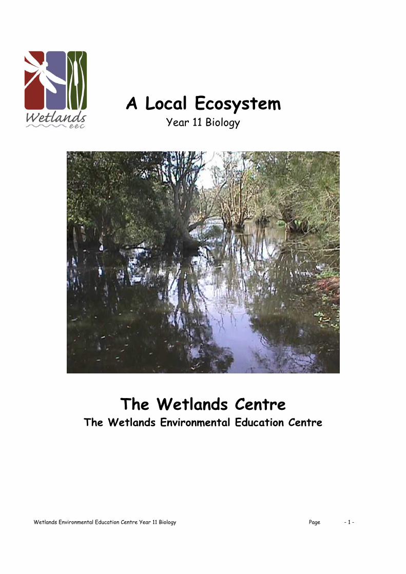
A Local Ecosystem
Year 11 Biology
The Wetlands Centre The Wetlands Environmental Education Centre
Wetlands Environmental Education Centre Year 11 Biology Page - 2 -
8.2 A Local Ecosystem
Content Focus:
Abundance, distribution and diversity of species are determined by biotic and abiotic factors.
There is a flow of energy and matter in an ecosystem. Each aquatic and terrestrial ecosystem is unique.
Students learn to:
Recall the difference between abiotic and biotic features of the environment Identify factors determining the distribution and abundance of a species in each
environment Describe the flow of energy through a natural ecosystem Identify some adaptations of living things to factors in their environment Identify and describe in detail adaptations of a plant and an animal from the local
ecosystem Recall some impacts of human activities on a ecosystem
Introduction: Define ‘Wetlands’: ‘An ecosystem is a community of organisms interacting with each other and with their physical environment.’ List some of the physical factors, which can impact on this ecosystem. List the functions of wetlands: List the values of wetlands: Briefly describe the study site with reference to its type, history and present condition.

Wetlands Environmental Education Centre Year 11 Biology Page - 3 -
Fieldwork:
1. Identification of study sites 2. Abiotic data collection at three sites 3. Biotic data collection - plants 4. Vegetation transect/profile 5. Biotic data collection - animals 6. Classification of pond animals 7. Wetland food web 8. Adaptation of a wetland plant and animal
9. Managing for wetlands and wildlife
10. Data loggers
11. Conclusion
Supporting documents:
1. Fieldwork Sheets 2. Shortland Wetlands Map 3. Shortland Wetlands Background Information 4. Pondlife Identification Chart 5. Plants of BHP Pond Identification Chart

Wetlands Environmental Education Centre Year 11 Biology Page - 4 -
Shortland Wetlands NSW

Wetlands Environmental Education Centre Year 11 Biology Page - 5 -
Shortland Wetlands Hunter Wetlands Centre, Australia Location : Central Coastal Plain at 32 53' S, 151 42' E. Located on the edge of Hexham Swamp in the suburbs of Newcastle. Bioregion: Sydney Basin. Area : 45 ha. Elevation : 0 m ASL. Wetland types according to Ramsar Classification System as featured in the Directory of Important Wetlands in Australia : (B10)Seasonal,/intermittent freshwater ponds and marshes on inorganic soils (B14)Freshwater swamp forest on inorganic soils (C2) Artificially constructed ponds The Shortland Wetlands System is a remnant floodplain wetlands on the edge of Hexham Swamp. The wetlands are located within the grounds of Hunter Wetlands Centre, Australia, in the suburb of Shortland in the Hunter region of New South Wales, Australia. The enclosed wetland reserve also houses a Visitors Centre and a range of facilities for visitor access. Situated on the eastern edge of Hexham Wetlands, it has a physical connection with the Hunter Estuary through Ironbark Creek. It is owned and operated by a non-profit, company, and is run by a small paid staff and a large corps of volunteers. The Hunter Wetland Centre was established in 1985 to encourage conservation of wetlands and their flora and fauna; to promote public awareness and education on the value of wetlands; to provide facilities for the scientific study of wetlands and; to cooperate with other like-minded organisations both within Australia and throughout the world. Previous land-uses on the site included market gardens, a land fill site and a football club. Today the site has been rehabilitated to provide a network of fresh and brackish ponds, providing habitat for a diverse range of wetland flora and fauna, including approximately 40 species of waterbirds. The freshwater swamp forest is used for breeding by 2000 breeding pairs of four egret species, and as an evening roost by approximately 4000 Australian White Ibis and Straw-necked Ibis. At least 20 other bird species have bred on the site. The Wetlands are filled by local rainfall and run-off from surrounding land.
In 2002 Kooragang Wetlands and Shortland Wetlands were renamed the Hunter Estuary Ramsar Wetlands and declared as significant wetlands under the Ramsar Convention.

Wetlands Environmental Education Centre Year 11 Biology Page - 6 -
Identification of Study Sites Aim: To randomly select study sites around BHP Pond, Shortland Wetlands, NSW Method: Randomly* circle three letter/number combinations below and find the sites on the map. Go to the sites to confirm that they are accessible and not too similar in terms of plants and water depth. Mark the sites clearly with the words Site 1, Site 2 and Site 3. *Alter your study site slightly if access is restricted.
2d 3c 4c 8c 11c 14c 15c 19c 20e 20g 20i 20n 16o q10 15o 12o 10p 9p 6o 5o 3n 2m 2l 2k 2j 2h 2g 14o Results:
Wetlands Environmental Education Centre Year 11 Biology Page - 7 -
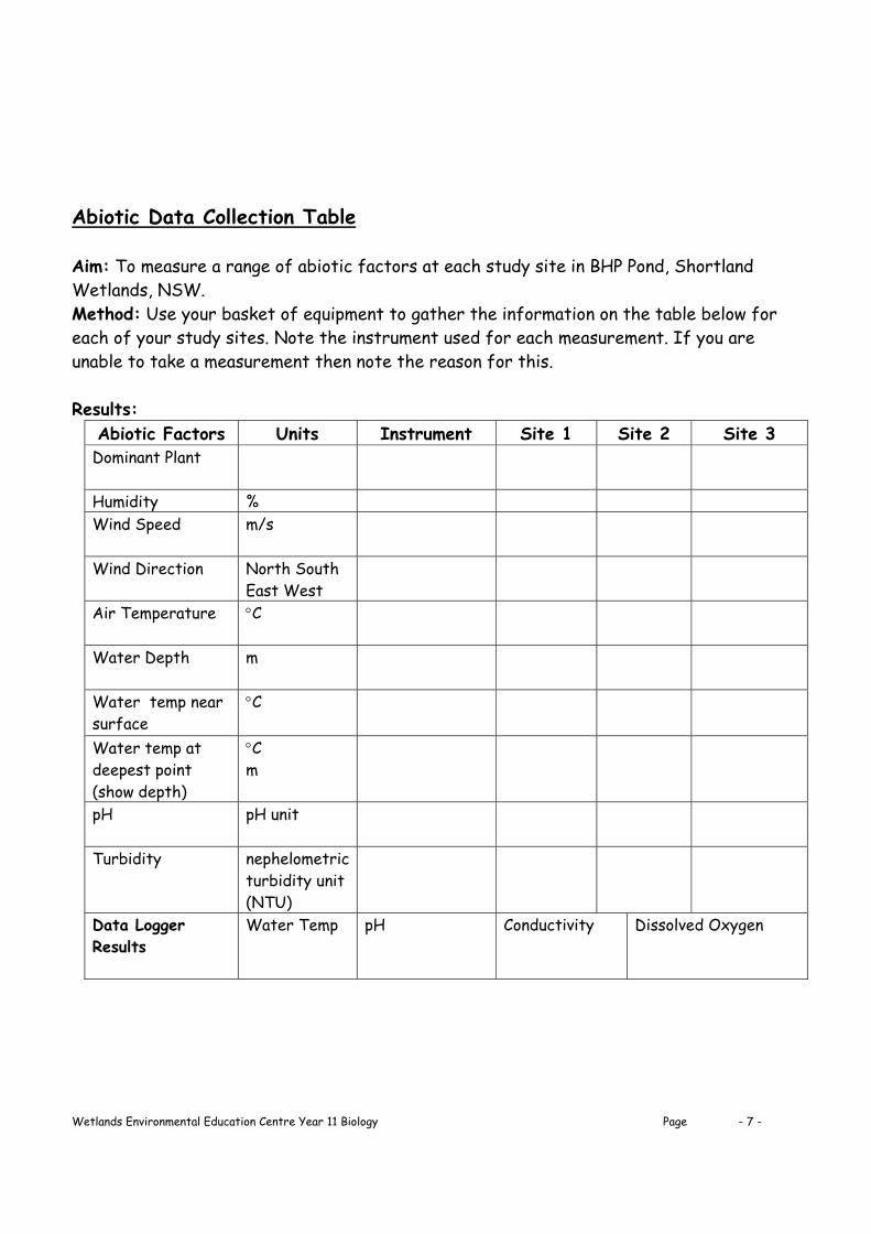
Abiotic Data Collection Table Aim: To measure a range of abiotic factors at each study site in BHP Pond, Shortland Wetlands, NSW. Method: Use your basket of equipment to gather the information on the table below for each of your study sites. Note the instrument used for each measurement. If you are unable to take a measurement then note the reason for this. Results:
Abiotic Factors Units Instrument Site 1 Site 2 Site 3 Dominant Plant
Humidity % Wind Speed
m/s
Wind Direction
North South East West
Air Temperature
C
Water Depth
m
Water temp near surface
C
Water temp at deepest point (show depth)
C m
pH
pH unit
Turbidity
nephelometric turbidity unit (NTU)
Data Logger Results
Water Temp pH Conductivity Dissolved Oxygen

Wetlands Environmental Education Centre Year 11 Biology Page - 8 -
Biotic Data Collection: Vegetation Quadrat (Site 1) Aim: To investigate the distribution of plants in each or your three study sites around BHP Pond, Shortland Wetlands, NSW. Method: Place the quadrat within your study site so that a portion of the quadrat is in the pond. Draw in the water line. Using a plan view, map the vegetation in the quadrat and develop a key, using your own symbols, to describe the plants. Use the field guide in your basket to identify each plant. Give your quadrat a title. Results:
Title: Vegetation Key
Symbol Plant Name
Conclusion:
Wetlands Environmental Education Centre Year 11 Biology Page - 9 -
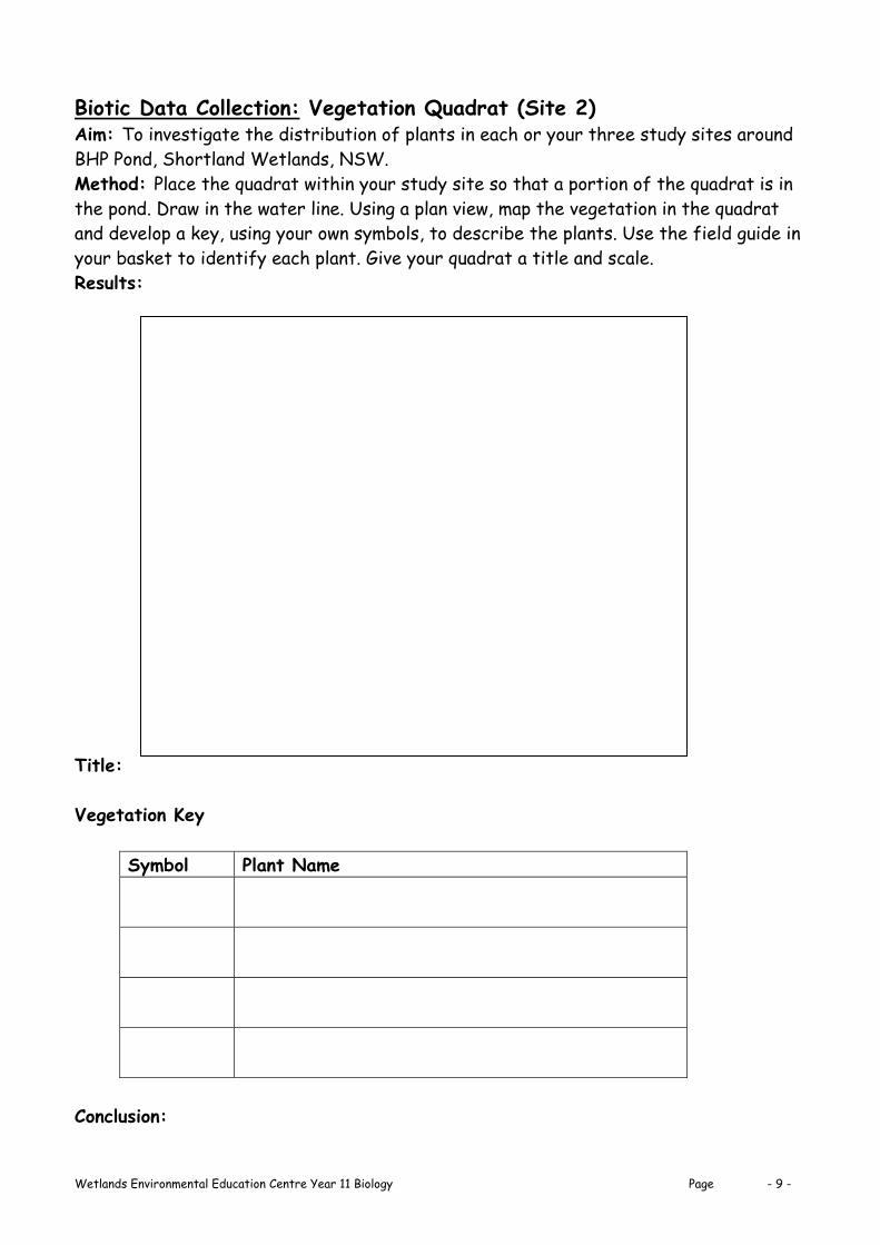
Biotic Data Collection: Vegetation Quadrat (Site 2) Aim: To investigate the distribution of plants in each or your three study sites around BHP Pond, Shortland Wetlands, NSW. Method: Place the quadrat within your study site so that a portion of the quadrat is in the pond. Draw in the water line. Using a plan view, map the vegetation in the quadrat and develop a key, using your own symbols, to describe the plants. Use the field guide in your basket to identify each plant. Give your quadrat a title and scale. Results:
Title: Vegetation Key
Symbol Plant Name
Conclusion:

Wetlands Environmental Education Centre Year 11 Biology Page - 10 -
Biotic Data Collection: Vegetation Quadrat (Site 3) Aim: To investigate the distribution of plants in each or your three study sites around BHP Pond, Shortland Wetlands, NSW. Method: Place the quadrat within your study site so that a portion of the quadrat is in the pond. Draw in the water line. Using a plan view, map the vegetation in the quadrat and develop a key, using your own symbols, to describe the plants. Use the field guide in your basket to identify each plant. Give your quadrat a title and scale. Results:
Title: Vegetation Key
Symbol Plant Name
Conclusion:
Wetlands Environmental Education Centre Year 11 Biology Page - 11 -
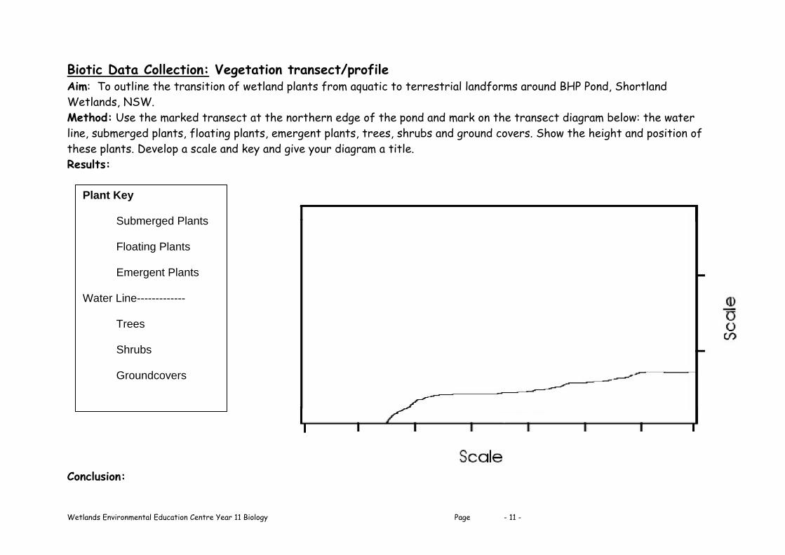
Biotic Data Collection: Vegetation transect/profile Aim: To outline the transition of wetland plants from aquatic to terrestrial landforms around BHP Pond, Shortland Wetlands, NSW. Method: Use the marked transect at the northern edge of the pond and mark on the transect diagram below: the water line, submerged plants, floating plants, emergent plants, trees, shrubs and ground covers. Show the height and position of these plants. Develop a scale and key and give your diagram a title. Results: Conclusion:
Plant Key
Submerged Plants Floating Plants Emergent Plants
Water Line------------- Trees Shrubs Groundcovers

Wetlands Environmental Education Centre Year 11 Biology Page - 12 -
Biotic Data Collection: Distribution and Abundance of Pond Animals Aim: To investigate the distribution and abundance of pond animals in your three study sites around BHP pond, Shortland Wetlands, NSW. Method: At each of your three study sites use the bucket to collect some water, place the water in the tray and use the dipnet to collect as many animals as possible from the pond. Collect animals from the surface of the water, in the water column and at the bottom of the pond. Avoid putting mud in your tray. Spend the same amount of time in each site. Once you have collected your animals, use the pond identification sheet to identify the animals and record the number of animals on the results table. Give your table a title. Take a second bucket and collect all the animals as you go. You need to collect a good sample of animals for your next section of work on food webs and adaptations. Results:
Phylum Class Common Name Numbers of animals in Site 1
Numbers of animals in Site 2
Numbers of animals in
Site 3 CHORDATA Actinipterygii Gudgeon Mosquito Fish Amphibia Tadpoles MOLLUSCA Gastropoda Pond snail Ramshorn snail ANNELIDA Oligochaeta Freshwater worm Hirudinea Leech ARTHROPODA Arachnida Water mite Crustacea Freshwater shrimp Water Flea Microscopic: Ostracod Copepod Other: Phylum: ARTHROPODA
Class Order Common Name Numbers of animals in
Site 1
Numbers of animals in
Site 2
Numbers of animals in
Site 3 Insecta Trichoptera Caddisfly larvae Ephemeroptera Mayfly nymph Odonata Dragonfly nymph Damselfly nymph Coleoptera Diving beetle Beetle larvae Hemiptera Water Boatman (True bugs) Backswimmer Oval Water Bug Water Scorpion Water Strider Diptera Mosquito larvae Bloodworm/Midgefly larvae Fly larvae Lepidoptera Moth larva (caterpillar)

Wetlands Environmental Education Centre Year 11 Biology Page - 13 -
Classification of Pond Animals Aim: To classify pond animals according to their feeding habits. Method: Take the animals you have already collected into the laboratory and identify them using the ‘Pond Animal Identification Sheet’. Use the information provided in the laboratory to determine the feeding method of each animal in your tray, sort them into categories and record it in the table below. Try and get two or three animals in each category. Use any animals you have seen today. Results:
Method of feeding Name of Animal Found
Herbivores: Feed directly on water plants
and algae.
Detrital Feeders: Feed on detritus – fragments
of dead plants (partly decomposed) and animals.
Filter Feeders: Feed on plankton (if present)
and small particles of detritus.
Carnivores: Catch and eat their prey. Small carnivores in the pond. Large carnivores mainly
outside the pond.
Scavengers: Eat dead organisms. What is the difference
between these and detrital feeders
Conclusion:

Wetlands Environmental Education Centre Year 11 Biology Page - 14 -
Wetland Food Web Aim: To construct a food web using animals you have seen today in and around BHP Pond, Shortland Wetlands, NSW. Method: Use the ‘Classification of Pond Animals’ table to construct an accurate food web. Transfer the information from the classification table to the web below. Use arrows to show the flow of energy through the web.
‘is eaten by’ ‘death and decay’
Results: LARGE CARNIVORES
SMALL CARNIVORES SCAVENGERS
HERBIVORES DETRITAL FEEDERS FILTER FEEDERS
DETRITUS
PHYTOPLANKTON AQUATIC PLANTS
LIGHT ENERGY FROM THE SUN
Conclusion:

Wetlands Environmental Education Centre Year 11 Biology Page - 15 -
Adaptations of Water Plants and Animals Aim: To identify and describe adaptations for a wetland animal and plant found in BHP Pond, Shortland Wetlands, NSW. An adaptation is a special feature that enables the organism to be better fitted to its environment. Method: Select and identify one wetland animal and plant. Use the hand lenses, microscopes and other equipment to investigate the features of each organism. Draw a detailed line drawing of each organism and note its adaptations in the table below. Give your table a title. Results:
Adaptations are usually classified as structural (a result of particular anatomical features), functional (a result of the organisms' metabolic capacities and tolerance limits - physiology) or behavioural (the things the members of the species can do in response to stimuli). Conclusion:
Organism Adaptations
Identify and sketch a wetland animal. List adaptations
Identify and sketch a wetland plant. List adaptations

Wetlands Environmental Education Centre Year 11 Biology Page - 16 -
Managing for Wetlands and Wildlife List the impacts human activities could have on these wetlands and classify them in terms of water, land, air and living things. Water Land Air Living Things
Choose three of those listed above and identify the possible sources. Alongside each of the sources, describe the possible effects of each of the threats upon the ecosystem. Form of Impact Possible Sources Possible effects of Impact
Air pollution Local Industry Lands on roof and washes into ponds with rain fall, chemical compounds in ponds
Rank the impacts from most damaging to least damaging upon the ecosystem. List possible solutions to the problem you have identified as the most damaging.

Wetlands Environmental Education Centre Year 11 Biology Page - 17 -
Data Loggers Data loggers were used to collect data during the fieldwork activities. Record the following information about their use. 1. What are data loggers? 2. What measurements were taken with the data loggers today? 3. Describe the method used to collect the Data Logger results. 4. Comment on the method used today. Is there a better way of using this equipment for field results? 5. What advantages / disadvantages do you see in the use of data loggers rather than other methods used today?

Wetlands Environmental Education Centre Year 11 Biology Page - 18 -
Conclusion to Fieldwork at Shortland Wetlands, NSW.
1. Describe each study site referring to the position; physical features; abiotic and biotic components of the site. Site 1: Site 2: Site 3: 2. Account for any differences between your study sites. 3. Identify three factors determining the distribution and abundance of a species in one or more of your study sites. 4. Name one wetland plant and one wetland animal and list three adaptations for each. 5. Describe the flow of energy through the wetland, give examples. 6. Evaluate the methods used to collect this data, recommend any changes to the methods used.

Wetlands Environmental Education Centre Year 11 Biology Page - 19 -

Wetlands Environmental Education Centre Year 11 Biology Page - 20 -

Wetlands Environmental Education Centre Year 11 Biology Page - 21 -

Wetlands Environmental Education Centre Year 11 Biology Page - 22 -