Embed Size (px)
Citation preview
A LINE OF HIGH PERFORMANCE DIGITAL PHOTOGRAMMETRIC WORKSTATIONS - THE SYNERGY OF GENERAL DYNAMICS, HELAVA ASSOCIATES, AND LElCA
S. B. Miller and J. E. Thiede Chief Engineer and Training Manager, Helava Associates Inc., USA
A. S. Walker Product Manager Digital Photogrammetry, Leica Heerbrugg AG, Switzerland
ISPRS Commission II
ABSTRACT:
A line of digital photogrammetric workstations for civilian use has evolved from the development by General Dynamics of specialized equipment for the defence market-place. More recently General Dynamics, Helava Associates, and Leica have begun to work together in the development and marketing of this product line. The result is an improved range of workstations for scanning, triangulation, data acquisition, digital terrain models and digital orthophoto production, which incorporates aspects of Leica's philosophy and software methodology designed to maximize productivity and ease of use.
KEY WORDS: Digital photogrammetry, Scanner, Aerial Triangulation, Digital Photogrammetric Workstation, Digital Terrain Models, Digital Orthophoto
1. INTRODUCTION
Today's computer technology provides the platforms necessary to achieve efficiency and functionality in digital image processing. This has allowed the implementation of photogrammetric instrumentation using software rather than hardware. Point marking and transfer devices, comparators, stereoplotters, rectifiers and orthophotoprojectors are now created using computers and software. Helava Associates Incorporated started building these systems as a sub-contractor to General Dynamics in the early 1980s and continued the development after becoming a wholly owned subsidiary in 1986. Less specialized versions were more recently derived for the non-military market-place. Brief histories are contained in Helava (1991b) and Miller et a1. (1992) • In 1991 an Agreement was reached with Leica, whereby Leica' s worldwide network could be deployed for the sales and marketing of the Helava product line and joint development work could proceed to tailor the range more closely to the demands of the market-place. The two companies therefore now offer a whole line of products to the photogrammetric and mapping community. The services available include hardware, software, system integration, customer training and support, and consulting. The digital photogrammetric products can be summarized as follows.
Scanning The DSW 100 Digital Scanning Workstation, consisting of a precise scanner and its control computer and software, is specially designed for high quality image scanning (digitizing) .
Triangulation Automatic and interactive point measurement for triangulation is efficiently done on the Digital Comparator Correlator System (DCCS), which is a software module available for the DSW 100.
87
Workstations An integrated series of Digital Photogrammetric Workstations (DPWs) completes the product range.
Leica's participation will be formally acknowledged by styling the product names Leica DSW 100 by He1ava and suchlike in sales literature and other promotional materials. Figure 1 depicts the general functionality of these products. They can be placed in context by reference to the overview by Dowman (1991).
The trend toward digital systems has received a push by rapid computer advancements, government development and other developers (Sarjakoski, 1981; Case, 1982). Perhaps the biggest advantage of digital photogrammetry over its predecessors is its ability to automate manual operations. Advances in computers and software algorithms have made completely digital photogrammetry expandable, flexible, efficient, and cost effective. Already it begins to compete with analytical photogrammetry in map compilation and revision and far exceeds the latter's performance in triangulation and the generation of digital terrain models and orthophotos. As automation advances and as the end users of photogrammetric information demand an increasing diversity of products, analytical photogrammetry must necessarily decline.
2. SCANNER
Until digital aerial cameras become readily available, most production work in digital photogrammetry will be dependent on the scanning of film negatives or diapositives. The DSW 100 Digital Scanning Workstation (figure 2) fulfils this function. It consists of a high quality xy scanning stage of dimensions 250 x 250 rom with a root mean square accuracy of less than 3 pm, a display monitor for the photographic image, a display monitor for the graphical user interface and the latest 80486-based personal computer. The software driving the system uses Unix (Unix is a trademark of AT&T) and X Windows (X Windows is a trademark of MIT) to provide a multi-tasking, windowing, state-of-the-art workstation.
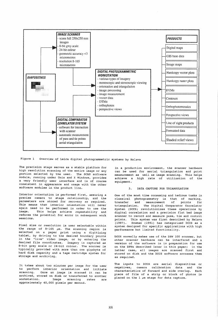
IMAGE SCANNER - scans full 250x250 mm inWUU~;I:i
images
rl Digital maps ... - 8-bit grey scale II1II"" - 24-bit colour
- geometric accuracy <3 I-- GIS base data micrometres
- resolution 8-165 micrometres I-- Image maps
DIGITAL PHOTOGRAMMETRIC I-- Hardcopy vector plots
OIAPOSITIVES WORKSTATION - various types of imagery
Hardcopy raster plots - monoscopic and stereoscopic viewing I--
..... ... - orientation and triangulation ... - image processing ...... DTMs
11liiio... - image measurement - - vector data t-- Contours -DTMs - orthophotos -- perspective views
Orthophotomosaics
I-- Perspective views
DIGITAL COMPARATOR CORRELATOR SYSTEM t-- Line of sight products
- software for interaction ... with scanner t-- Formatted data .... - automatic measurement
of pass and tie points '-- Shaded relief views
- aerial triangulation
Figure 1 Overview of Leica digital photogrammetric systems by Helava
The precision stage serves as a stable platform for high resolution scanning of the entire image or any portion selected by the user. The SCAN software module, running under Unix and X Windows, provides a very friendly user interface and is of course consistent in appearance and usage with the other software modules in the product line.
Interior orientation is performed first, assuring a precise camera to stage relationship, and the parameters are stored for recovery as required. This means that interior orientation will never again need to be performed in order to use the image. This helps achieve repeatability and reduces the potential for error in subsequent work sessions.
Pixel size or resolution is user selectable within the range of 8-165 ~m. The scanning region is selected on a paper print using a digitizing tablet, by driving to the desired boundary points in the "live" video image, or by entering the desired film coordinates. Imagery is captured as a-bit grey scale or 24-bit colour. The scanner is typically provided with more than one gigabyte of hard disk capacity and a tape cartridge system for storage and archiving.
It takes about two minutes per image for the user to perform interior orientation and initiate scanning. Once an image is scanned it can be archived, stored on disk or transferred to another workstation. Image scanning rates are approximately 40,000 pixels per second.
88
In a production environment, the scanner hardware can be used for aerial triangulation and point measurement as well as image scanning. This helps achieve a high rate of utilization of the equipment.
3. DATA CAPTURE FOR TRIANGULATION
One of the most time consuming and tedious tasks in classical photogrammetry is that of marking, transfer and measurement of points for triangulation. The Digital comparator Correlator System (DCCS) revolutionizes these operations by digital correlation and a precision flat bed image scanner to record and measure pass, tie and control points. This system was first described by Helava (1987). Dowman (1991) has categorized DCCS as a system designed for specific applications with high performance but limited functionality.
DCCS normally makes use of the DSW 100 scanner, but other scanner hardware can be interfaced and a version of the software is in preparation for use on the DPWs described later in this paper; in the latter case, all images are scanned first and stored on disk and the DCCS software accesses them as required.
The inputs to DCCS negatives, camera
are aerial calibration
diapositives data and
or the
characteristics of forward and side overlap. Each piece of film of a strip or block of photos is placed on the 1 ~m stage for data capture.

Figure 2 Leica DSW 100 by Helava
Image patches are scanned and stored in the computer, after interior orientation, for each pass, tie and control point location. Each point is automatically matched to achieve conjugate and mUlti-image match points as the strip or block of images is processed. Semi-automatic and manual measurements are performed interactively in problem areas. After point measurement, the image coordinates can be output to many standard triangulation programs, such as ALBANY, PAT-B and PAT-M. ALBANY is offered as an optional software module, fully integrated on the workstation. The triangulation results can then be downloaded in the usual way to facilitate orientations on analogue, analytical and digital stereoplotters. The pass and tie points, of course, have been neither documented on paper nor marked on the emulsion, but they are known by their fiducial coordinates and
can therefore be effortlessly located on either analytical or digital workstations.
The key advantages of the DCCS include the speed and consistency of point measurements. Typical image throughput is 40 images in an 8 hour shift with modest operator training. Eye and user fatigue is not a factor as very little point measurement is done manually. This means that it is no longer necessary to have the best point measurement operator run the comparator. Accuracy is consistent as human fatigue plays a minor role in point measurement quality. Typical root mean square errors after triangulation are less than 5 /-lm. Customers are already reporting satisfactory experiences (Newby, 1990; Han, 1992) and it is worth remembering that the acquisition of a DSW 100 with DCCS software frees an analytical plotter for map compilation and revision.
89
4. DIGITAL PHOTOGRAMMETRIC WORKSTATIONS
The Leica DPW by Helava is the newest tool for photogrammetric data extraction. This tool receives digital imagery and data to produce a wide variety of products. Automation is applied using both software and hardware to increase the productivity over traditional methods. Automatic functions supported with interactive functions for the user assure quality products with increased throughput, less operator training and less user fatigue.
The DPW is a stereo or mono softcopy image exploitation workstation that supports applications with stringent geo-positioning requirements. The workstation functions with imagery input from a wide variety of platforms, including SPOT, Landsat, and frame sensors. The exploitation tools include data preparation, data extraction and product generation. The DPWs offer a wide variety of functions (figure 3 is an indication), which provide the flexibility and expandability for the user to enter a variety of applications. The DPW range may be included in the category described by Dowman as workstations with "performance and functionality of analytical plotter with image processing and computer assisted feature extraction" (1991, 31).
4.1 DPW Hardware
A typical workstation configuration is shown in figure 4. Hardware for the DPWs consists of standard, "off the shelf" components which are commercially available. This affords cost effective upgrade and maintenance of the equipment. Current hardware platforms available include Sun workstations and 80486-based personal computer Unix workstations. Typical disk memory includes 1 to 2
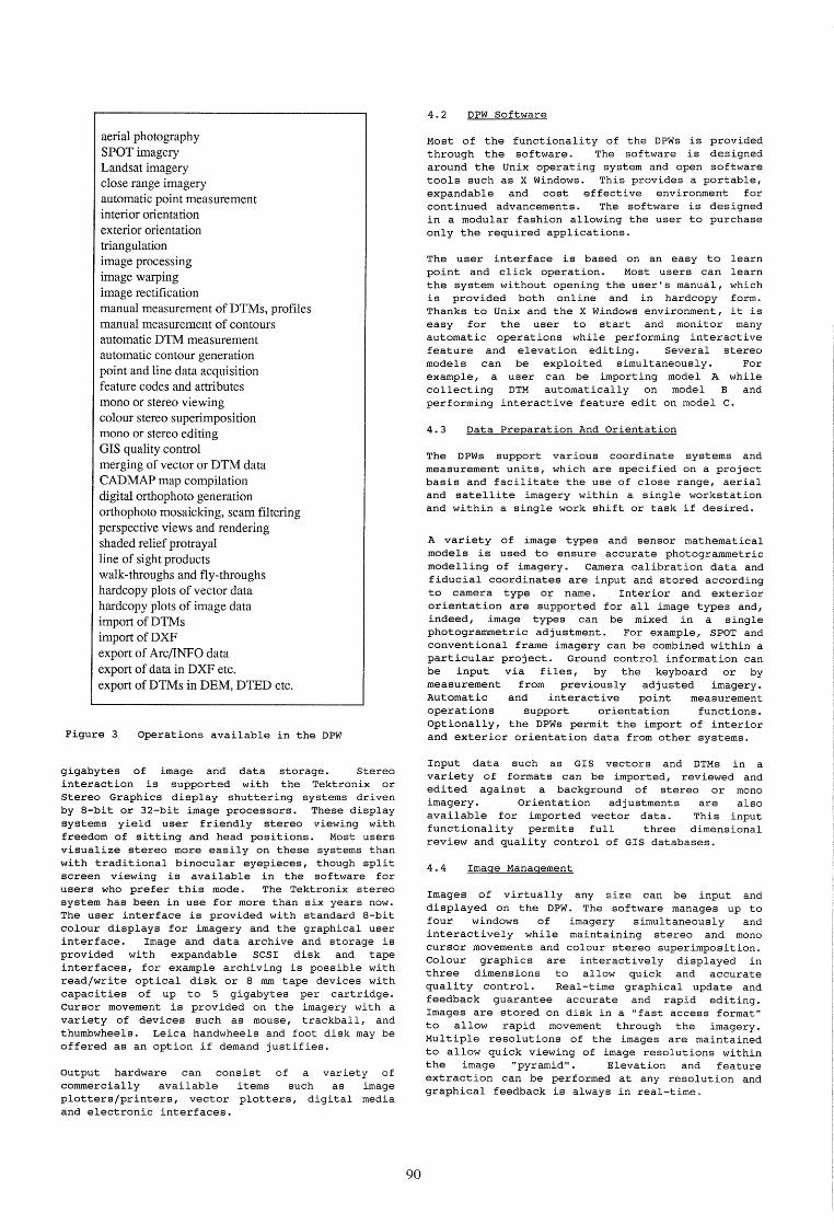
aerial photography SPOT imagery Landsat imagery close range imagery automatic point measurement interior orientation exterior orientation triangulation image processing image warping image rectification manual measurement of DTMs, profiles manual measurement of contours automatic DTM measurement automatic contour generation point and line data acquisition feature codes and attributes mono or stereo viewing colour stereo superimposition mono or stereo editing GIS quality control merging of vector or DTM data CAD MAP map compilation digital orthophoto generation orthophoto mosaicking, seam filtering perspective views and rendering shaded relief protrayal line of sight products walk-throughs and fly-throughs hardcopy plots of vector data hardcopy plots of image data import of DTMs import of DXF export of Arc/lNFO data export of data in DXF etc. export ofDTMs in DEM, DTED etc.
Figure 3 Operations available in the DPW
gigabytes of image and data storage. stereo interaction is supported with the Tektronix or Stereo Graphics display shuttering systems driven by 8-bit or 32-bit image processors. These display systems yield user friendly stereo viewing with freedom of sitting and head positions. Most users visualize stereo more easily on these systems than with traditional binocular eyepieces, though split screen viewing is available in the software for users who prefer this mode. The Tektronix stereo system has been in use for more than six years now. The user interface is provided with standard 8-bit colour displays for imagery and the graphical user interface. Image and data archive and storage is provided with expandable SCSI disk and tape interfaces, for example archiving is possible with read/write optical disk or 8 mm tape devices with capacities of up to 5 gigabytes per cartridge. Cursor movement is provided on the imagery with a variety of devices such as mouse, trackball, and thumbwheels. Leica handwheels and foot disk may be offered as an option if demand justifies.
output hardware can consist of a variety of commercially available items such as image plotters/printers, vector plotters, digital media and electronic interfaces.
90
4.2 DPW Software
Most of the functionality of the DPWs is provided through the software. The software is designed around the Unix operating system and open software tools such as X Windows. This provides a portable, expandable and cost effective environment for continued advancements. The software is designed in a modular fashion allowing the user to purchase only the required applications.
The user interface is based on an easy to learn point and click operation. Most users can learn the system without opening the user's manual, which is provided both online and in hardcopy form. Thanks to Unix and the X Windows environment, it is easy for the user to start and monitor many automatic operations while performing interactive feature and elevation editing. Several stereo models can be exploited simultaneously. For example, a user can be importing model A while collecting DTM automatically on model Band performing interactive feature edit on model C.
4.3 Data Preparation And Orientation
The DPWs support various coordinate systems and measurement units, which are specified on a project basis and facilitate the use of close range, aerial and satellite imagery within a single workstation and within a single work shift or task if desired.
A variety of image types and sensor mathematical models is used to ensure accurate photogrammetric modelling of imagery. Camera calibration data and fiducial coordinates are input and stored according to camera type or name. Interior and exterior orientation are supported for all image types and, indeed, image types can be mixed in a single photogrammetric adjustment. For example, SPOT and conventional frame imagery can be combined within a particular project. Ground control information can be input via files, by the keyboard or by measurement from previously adjusted imagery. Automatic and interactive point measurement operations support orientation functions. Optionally, the DPWs permit the import of interior and exterior orientation data from other systems.
Input data such as GIS vectors and DTMs in a variety of formats can be imported, reviewed and edited against a background of stereo or mono imagery. Orientation adjustments are also available for imported vector data. This input functionality permits full three dimensional review and quality control of GIS databases.
4.4 Image Management
Images of virtually any size can be input and displayed on the DPW. The software manages up to four windows of imagery simultaneously and interactively while maintaining stereo and mono cursor movements and colour stereo superimposition. Colour graphics are interactively displayed in three dimensions to allow quick and accurate quality control. Real-time graphical update and feedback guarantee accurate and rapid editing. Images are stored on disk in a "fast access format" to allow rapid movement through the imagery. Multiple resolutions of the images are maintained to allow quick viewing of image resolutions within the image "pyramid". Elevation and feature extraction can be performed at any resolution and graphical feedback is always in real-time.
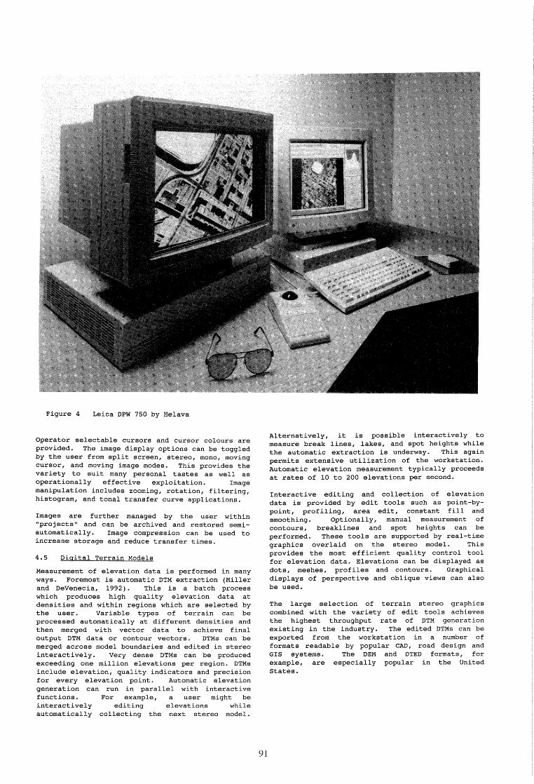
Figure 4 Leica DPW 750 by Helava
Operator selectable cursors and cursor colours are provided. The image display options can be toggled by the user from split screen, stereo, mono, moving cursor, and moving image modes. This provides the variety to suit many personal tastes as well as operationally effective exploitation. Image manipulation includes zooming, rotation, filtering, histogram, and tonal transfer curve applications.
Images are further managed by the user within "projects" and can be archived and restored semiautomatically. Image compression can be used to increase storage and reduce transfer times.
4.5 Digital Terrain Models
Measurement of elevation data is performed in many ways. Foremost is automatic DTM extraction (Miller and DeVenecia, 1992). This is a batch process which produces high quality elevation data at densities and within regions which are selected by the user. Variable types of terrain can be processed automatically at different densities and then merged with vector data to achieve final output DTM data or contour vectors. DTMs can be merged across model boundaries and edited in stereo interactively. Very dense DTMs can be produced exceeding one million elevations per region. DTMs include elevation, quality indicators and precision for every elevation point. Automatic elevation generation can run in parallel with interactive functions. For example, a user might be interactively editing elevations while automatically collecting the next stereo model.
9]
Alternatively, it is possible interactively to measure break lines, lakes, and spot heights while the automatic extraction is underway. This again permits extensive utilization of the workstation. Automatic elevation measurement typically proceeds at rates of 10 to 200 elevations per second.
Interactive editing and collection of elevation data is provided by edit tools such as point-bypoint, profiling, area edit, constant fill and smoothing. Optionally, manual measurement of contours, breaklines and spot heights can be performed. These tools are supported by real-time graphics overlaid on the stereo model. This provides the most efficient quality control tool for elevation data. Elevations can be displayed as dots I meshes, prof iles and contours. Graphical displays of perspective and oblique views can also be used.
The large selection of terrain stereo graphics combined with the variety of edit tools achieves the highest throughput rate of DTM generation existing in the industry. The edited DTMs can be exported from the workstation in a number of formats readable by popular CAD, road design and GIS systems. The DEM and DTED formats, for example, are especially popular in the United States.
4.6 Acquisition of Map Data
Feature extraction is the process of delineating and defining features and recording their two or three dimensional ground coordinates. Many tools are available with a wide variety of functionalities. Two approaches are adopted. A Helava software module is offered which provides the basic tools for data acquisition. Alternatively, several sophisticated mapping packages, which are already implemented on analogue
and analytical stereoplotters, are becoming available. Both the Helava and the other modules allow output of map data in a variety of CAD, GIS and digital mapping formats and the mapping packages also support a broad selection of plotting devices.
The Helava software is described first, though many of the mapping functions are included in the mapping packages also, since these access the same low level, fundamental functions of the workstation. Stereoscopic and monoscopic data extraction is performed in static, dynamic, spline, curve, squaring, rubber-banding, and mixed modes. This provides flexibility and increased throughput. Graphical superimposition permits instant feedback and the overview (small scale) image display gives a fast, useful impression of the extent and completeness of data collection from the entire stereomodel.
Another important facility is the definition of feature attributes and attribute types. The user may define feature layers, classes and graphical attributes. Additionally, it is possible to define as many attributes for each feature class as desired. Attributes can be numerical or textual characteristics of a feature such as composition, age, size, purpose, and usage. Features may be copied, translated, rotated, stretched and scaled. Standard features may be stored and "placed" within the stereo model as desired. Once placed, they can be quickly adjusted (rotated, translated, scaled) into position. This increases throughput for repetitive features.
Complex feature data can now be extracted as volumes (solids) if desired. This is done interactively or with automatic tools for intersecting with DTM files. A DTM may also be used, when collecting data from stereo or mono imagery, to keep the floating mark on the ground.
The first of the high performance mapping packages to be implemented is CADMAP from Design Data Inc. This is an additional tool for feature extraction and map generation. It provides interactive data acquisition, model merging, batch editing, map symbolization, map sheet production, plotting and much more. CADMAP is specifically designed for photogrammetric and cartographic data creation and edit. It offers interfaces to other stereo plotters, line plotters and other CAD and GIS systems. It can be used within the DPW for three dimensional data collection and edit with imagery or for graphical editing in two dimensions.
92
It is planned that CADMAP will be followed by other well known packages, particularly the MAPCE and PR0600 products from the Leica range. Just as CADMAP and PR0600 can incorporate a digitizing tablet for input, MAPCE will use the PFKB5 input device familiar from its operation on the Leica analytical stereoplotters. The porting of these packages on to the DPWs is vital since it enables the user to enjoy the same mapping environment across the whole spectrum of photogrammetric workstations, from early analogue instruments to the powerful DPWs described in this paper. Furthermore, these packages on the DPWs will incorporate colour stereo superimposition, a distinct advantage over their implementations on most analogue and analytical instruments. Users, therefore, will be able to continue to work with their preferred packages as they upgrade to DPWs and will benefit from higher productivity also.
4.7 Orthophotos
Orthophotos are generated automatically from the imagery in conjunction with a DTM, the latter derived from measurements on the DPW or obtained externally. Mosaicking is available to stitch together the component orthophotos with invisible seams and correct local shortfalls in image quality, such as dark shadows, or distortions in radiometry or geometry. This provides for creation of balanced, seamless imdge databases.
Orthophoto image databases can be generated and maintained in a seamless virtual fashion. This imagery can be displayed and used for feature extraction, display, edit, and quality control. Elevation is automatically derived for monoscopic feature display and extraction. Image maps can be generated from any portion of the orthophoto database. Digital image and orthophoto outputs can be provided to GIS displays such as Arc/INFO.
Orthophoto images can be combined with vector information, including labelled grids, to produce orthophoto maps in raster form, ready for output to a selection of film writers and raster plotters.
4.8 Perspective Views
DTM and feature volume data can be combined to produce perspective views. The perspective view function allows the generation of images as seen from arbitrary viewpoints. The views are rendered by draping imagery over the terrain and feature data using a depth-buffer algorithm.
Perspective views can be generated singly, or as a sequence of frames that may be played back as an animated walk-through or fly-through. The user interactively defines a fly-through route by drawing a graphical line through the stereomodel in
ground space. The velocity, look angles, way points, lock-on points and pivot points may be specified by the user or left to the system defaults.
Shaded relief and line of sight products can also be generated.
4.9 Integrated systems of DSWs and DPWs
Figure 4 above shows a DPW 750. This model is based on a SPARCstation 2 (SPARCstation is a trademark of SPARC International, Inc., licensed exclusively to Sun Microsystems, Inc.) and offers stereoscopic viewing by means of the Tektronix SGS 625 system. A monoscopic version, the DPW 650, is also available. It must be remembered that many digital photogrammetric operations are not stereoscopic: stereoscopy is essential only for map compilation and revision and for interactive measurement and editing of DTMs. The DPW 710 and 610 are, respectively, stereoscopic and monoscopic workstations running on 80486-based personal computers.
All DSWs and DPWs are supplied with Ethernet connections. Thus they can be linked together for the transmission of images, parameters and results as well as to devices for input and output. Customers' existing Ethernet facilities can be used too. Thus extensive digital photogrammetric systems are readily available and networking to installed photogrammetric workstations, whether analogue or analytical, is straightforward. Networks of heterogeneous photogrammetric workstations not only offer clear versatility and productivity, but, importantly, enable the user to upgrade gradually and comfortably to digital systems as finances and workload permit. This scenario is a major justification for the developments being undertaken by Helava and Leica to provide to many customers the same mapping software on their digital photogrammetric workstations as they have chosen on their analogue and analytical.
5. THE ROLE OF LEICA
As indicated above, an Agreement dating from 1991 establishes Leica as the distributor of the Helava product range and opens the way for joint developments, of which the implementations of MAPCE and PR0600 will be among the earliest and most apparent. Leica's long experience with an enormous range of customers from the private, public and military sectors will also be reflected in subtle changes gradually occurring throughout the Helava software, especially with regard to customers' preferred procedures and user interfaces.
At the time of writing (May 1992), there is already evidence in the form of orders that the sales ability of the Leica network is bearing fruit. Leica's responsibilities, of course, are only beginning when a sale is closed. The installation of the system and the training and support of the customer are firmly in Leica's remit. This commitment in its turn frees the human resources of Helava to concentrate on product development, assisted where appropriate by research and development staff from Leica.
Numerous authors, for example Helava (1991a), Ackermann (1992) and Leberl (1991, 1992), have commented on the power of digital photogrammetry and the dawning of a new era as digital photogrammetric workstations supersede their analogue and analytical forebearers. This succession is already in progress and the combination of Helava and Leica will ensure not only that mapping customers can continue their work on new, higher performance equipment, assisted by automated procedures wherever practical, but also that the many customers are properly satisfied who want to benef it from the wide choice of output products which digital photogrammetry can provide.
93
6. SUMMARY
A brief review of the General Dynamics/Helava/Leica digital photogrammetric product line has been presented. These workstations facilitate the generation of a wide range of products using efficient and flexible software tools. Their versatility and cost effectiveness are now available to the commercial sector largely owing to internal and previously derived government development in the United States. This lineage has recently been broadened through Leica's experiences of development, sales and marketing of photogrammetric equipment to a broad spectrum of customers. The extensive range of applications within these workstations ensures high rates of utilization and corresponding cost-effectiveness for the customer.
REFERENCES
Ackermann, F., 1992. Strukturwandel in der Photogrammetrie. Zeitschrift fUr Photogrammetrie und Fernerkundung, 1992(1):2-5.
Case, J.B., 1982. The Comparator/Compiler (DCCS). Archives of Photogrammetry! Ottawa, Canada, pp. 23-29.
Digital Stereo In: International Vol. 24 Part II,
Dowman, I. J, photogrammetric
1991. Design workstations. In:
of digital Ebner, H.,
Fritsch, D. and Heipke, C. (eds.), Digital Photogrammetric Systems, Wichmann, Karlsruhe, pp. 28-38.
Han, C.S., 1992. Digital photogrammetry at the Survey Department. In: International Archives of Photogrammetry and Remote Sensing, Vol. 29 Part II, Washington DC, USA.
Helava, U.V., 1987. Digital comparator Correlator System. In: GrUn, A. et ale (eds.), Proceedings, Intercommission Conference on Fast Processing of Photogrammetric Data, Interlaken, Switzerland, pp. 404-418.
Helava, U. V. , 1991a. photogrammetry. The Finland, 12(2):57-64.
Prospects Photogrammetric
in digital Journal of
Helava, U.V., 1991b. State of the art in digital photogrammetric workstations. The Photogrammetric Journal of Finland, 12(2):65-75.
Leberl, F.W., 1991. The promise of softcopy photogrammetry. In: Ebner, H., Fritsch, D. and Heipke, C. (eds.), Digital Photogrammetric Systems, Wichmann, Karlsruhe, pp. 3-14.
Leberl, F.W., 1992. Towards a new photogrammetry. Zeitschrift fUr Photogrammetrie und Fernerkundung, 1992(1):9-12.
Miller, S.B. and DeVenecia, K.J., 1992. Automatic elevation extraction and the digital photogrammetric workstation. In: ASPRS Technical Papers, 1992 ASPRS-ACSM Annual Convention, Albuquerque, Vol. 1, pp. 572-580.
Miller, S.B., Helava, U.V. and DeVenecia, K.J., 1992. softcopy photogrammetric workstations. Photogrammetric Engineering & Remote Sensing, 58(1) :77-83.

Newby, P.R.T., 1990. digitising at the International Archives Sensing, Vol. 28 Part 656.
Sarjakoski, T., 1981. digital stereoplotter. of Finland, 2:95-100.
New initiatives in image Ordnance Survey. In:
of Photogrammetry and Remote 3/2, Wuhan, China, pp. 639-
Concept of a completely The Photogrammetric Journal
94