Embed Size (px)
Citation preview
International Journal of Wireless & Mobile Networks (IJWMN) Vol. 10, No. 3, June 2018
DOI: 10.5121/ijwmn.2018.10305 51
A HYBRID FUZZY SYSTEM BASED COOPERATIVE
SCALABLE AND SECURED LOCALIZATION SCHEME FOR
WIRELESS SENSOR NETWORKS
Abhishek Kumar
iNurture Education Solutions Private Limited, India
ABSTRACT
Localization entails position estimation of sensor nodes by employing different techniques and
mathematical computations. Localizable sensors also form an inherent part in the functioning of IoT
devices and robotics. In this article, the author extends1 a novel scheme for node localization implemented
using a hybrid fuzzy logic system to trace the node locations inside the deployment region, presented by the
Abhishek Kumar et. al. The results obtained were then optimized using Gauss Newton Optimization to
improve the localization accuracy by 50% to 90% vis-à-vis weighted centroid and other fuzzy based
localization algorithms. This article attempts to scale the proposed scheme for large number of sensor
nodes to emulate somewhat real world scenario by introducing cooperative localization in previous
presented work. The study also analyses the effectiveness of such scaling by comparing the localization
accuracy. In next section, the article incorporates security in the proposed cooperative localization
approach to detect malicious nodes/anchors by mutual authentication using El Gamel digital Signature
scheme. A detailed study of the impact of incorporating security and scaling on average processing time
and localization coverage has also been performed. The processing time increased by a factor of 2.5s for
500 nodes (can be attributed to more number of iterations and computations and large deployment area
with small radio range of nodes) and coverage remained almost equal, albeit slightly low by a factor of
1% to 2%. Apart from these, the article also discusses the impact of adding extra functionalities in the
proposed hybrid fuzzy system based localization scheme on processing time and localization accuracy.
Lastly, this study also briefs about how the proposed scalable, cooperative and secure localization scheme
tackles the type of attacks that pose threat to localization.
KEYWORDS
Sugeno Fuzzy Inference Systems, Mamdani Fuzzy Inference Systems, Localization algorithms, Gauss
Newton method, Cooperative localization, Mutual authentication, Elgamel Digital Signature
1. INTRODUCTION
The unprecedented surge in the usage of sensors and thus the sensor networks in new avenues
such as cyber physical systems, smart homes, smart cities etc. has attracted the attention of
multitude of researchers across the globe. Sensor networks are autonomous collection of tiny,
resource constrained sensor nodes, which operate in ad hoc manner and forwarding data and
This article is extended version of paper titled “A Sugeno- Mamdani Fuzzy System Based Soft Computing
Approach Towards Sensor Node Localization with Optimization” presented in 3rd International Conference
on Next Generation Computing Technologies (NGCT 2017), Dehradun India
International Journal of Wireless & Mobile Networks (IJWMN) Vol. 10, No. 3, June 2018
52
information sensed or gathered to base station or sink node. The manner in which they are
constructed, these nodes and the network are subjected to challenges such as limited battery or
power source, limited coverage region, no support in terms of available infrastructure,
susceptible to interferences in communication due to open nature of media of transmission,
channel constraints in terms of available bandwidth etc.
Localization refers to the computation process of figuring out the position of sensor nodes in the
rectangular deployment area by the aide of some known nodes called anchors/landmarks.
Categorically speaking, any localization technique can be either range based or range free. Range
based schemes rely on and utilize explicit ranging information in terms of Received Signal
Strength Indicator (RSSI), Time of Arrival (ToA), Time Difference of Arrival (TDoA) etc to
measure the range or distance in terms of variation in parameters of signal such as signal strength
and latency in signal reception. Range free schemes, on the other hand, utilize the connectivity
information in terms of hop count. Their computation is simpler and does not require antenna
arrays, but need more anchors/landmarks (nodes whose position is already known to us and
would be used to compute the location of other unknown sensors in the deployment region). Secure localization is an imperative task as the sensor operations are typically unattended and
media of communication is insecure. Thus any adversary can tamper with the sensor operation or
any malicious node can be added into the deployment region and can attack as genuine
node/anchor. In context of localization, the security is particularly important because any
imprecise or fake location information can affect the routing process (any position broadcasted as
unreachable from a particular node might corrupt the entire routing table of that node), data
aggregation, packet forwarding (a malicious node can collude with another node to create a
wormhole and thus intercept all packets forwarded via that wormhole link). Other attacks such as
Sybil attack, masquerading attacks etc. pose similar threat to localization and the overall
topology of wireless sensor network. It is the node’s task to compute the location information,
considering distributed localization scheme but the onus lies on the base station to ensure that
such information is accurate because the resources at the disposal of individual sensor nodes are
not sufficient to verify the location and validate the other sensors nodes from which it is
receiving data or anchor nodes from which it is receiving beacons to compute location.
Another issue in localization is how to scale or extend the existing localization algorithms to
large number of sensor nodes. Most of the existing work on localization take into consideration
50-150 nodes and then deploy their approach to find their location. The study presented by the
author in [1] tackles location determination of 100 nodes efficiently with cost effective, low
latency, low overhead. In this extended version we are formulating cooperative and scalable
localization scheme having hybrid Sugeno-Mamdani fuzzy system as its core, to tract
localization of 500 nodes deployed in a particular region.
The organization of the rest of the paper is in following manner: Section 2 presents an intensive
literature review on existing works done on hybrid fuzzy systems, secured localization and
cooperative localization schemes. Section 3 covers the hybrid fuzzy logic system based
localization scheme presented by the Abhishek Kumar et al. in [1]; Section 4 discusses a
cooperative localization scheme; Section 5 incorporates security with digital signature scheme to
achieve node validation via mutual authentication; followed by conclusion and future research
directions in Section 6.
International Journal of Wireless & Mobile Networks (IJWMN) Vol. 10, No. 3, June 2018
53
2. RELATED WORK
The work done by Ashok Kumar et al. in [2] [3] devised a fuzzy based localization scheme by
feeding RSSI and Link Quality Indicators (LQI) as inputs to the constructed fuzzy model (the
rule set) and weight as output. The weight was then utilized into weighted centroid algorithm to
compute the position coordinated of unknown sensors. The authors have comprehensively
studied Sugeno type fuzzy system, Mamdani type fuzzy system, a hybrid of their combinations
and ANFIS trained Sugeno type fuzzy system. The localization error of their experiments and
simulations varies from 0.76m to 0.95m, depending upon the type of fuzzy inference system
used. The work presented in [1] has drawn motivation from the study done by above authors, as
an attempt to improve the localization accuracy and cost by using least number of anchors/
landmarks to achieve the localization of unknown sensor nodes.
A somewhat similar study has been done by Arbabi Monfared in [4]. The author modelled a nine
rule-set based Sugeno type fuzzy system to compute weigh values in range [0, 1] corresponding
to a RSSI value in range [-80 dB, 0 dB]. Taking into the account the Additive Gaussian White
Noise (AWGN) with Signal to Noise ratio value of 10 dB, the average localization error was 0.
30m.The same study conducted in outdoor experiments led to localization error of 0.53m.
The study done by Gharghan et al. in [5], the authors constructed an ANFIS (Adaptive Neuro
Fuzzy Inference System) trained Mamdani fuzzy system with three, five and seven membership
functions. For the purpose of training, a ratio of deployed nodes was put in training set and rest
of the nodes in testing set. The study was performed in indoor environment and was replicated in
outdoor conditions. The localization error, both mean and root square error, was greater in case
of indoor experiment scenario as compared to experiment conducted in outdoor environment,
largely due to effects of multipath propagation and scattering. Also, it was observed that with
increase in the number of membership functions and rules, the localization error reduced
gradually.
A few more existing works on fuzzy system based location estimation have been done in [6] [7].
All of these works model the range component such as RSSI or ToA and weight as set of rules.
The Fuzzy system, then, depending on whether it is a Sugeno fuzzy logic or Mamdani fuzzy
logic, is implemented on set of rules modelled.
In their study, Nan et al. in [8] least square estimation and maximum likelihood computation
techniques cannot effectively tackle location estimation in cooperative manner as they do not
consider position of neighbour nodes. The situation gets more troublesome in sparse networks in
harsh environments as we have lesser number to nodes to gather information from. Authors
proposed a distributed and cooperative location estimation technique incorporating Gaussian
Message Passing (GMP) by non-linearly modelling the network as factor graphs. Since the
network was modelled non-linearly, Taylor expansion was used to approximate non-linear
factors. Authors compared their scheme with existing Monte Carlo scheme and Sum Product
Algorithm (SPA) to claim that complexity and communication overhead of their proposed
technique was 50-70% lower than SPA and MCL.
In the study done by [9] authors took into consideration distance and direction to propose hybrid
message passing based location determination technique. Authors then used Bayesian estimation
to approximate Minimum Mean Square Error (MMSE). The position of neighbor nodes was also
taken into consideration as posterior distribution. The algorithm was numerically stable as
International Journal of Wireless & Mobile Networks (IJWMN) Vol. 10, No. 3, June 2018
54
convergence was achieved in lesser than 10 iterations. Computational complexity was directly
proportional to square of number of neighbor nodes. The mean localization error was 0.45cm,
better than any other message passing based localization algorithm. T.Chowdhary in his PhD
Thesis [10] studied distributed cooperative localization technique based on Gaussian Modelling
of sensor networks. The author implemented several algorithms namely: Expected Maximization
(EM), Gaussian Mixture Model (GMM), Broyden- Fletcher- Goldfrab- Shanno (BFGS) Quasi
Newton (QN), and Davidan- Fletcher- Powell (DFP). All of the proposed algorithms
approximate the maximum likelihood estimates and scale well with large sensor networks. The
proposed scheme in this paper has been compared against all the above mentioned techniques.
Here it must be noted that all the above mentioned algorithms take into consideration Cramer
Rao Lower Bounds (CRLB) whereas, our scheme outperforms them without any consideration of
lower bounds.
DV hop localization technique [11] is a connectivity based scheme where localization is achieved
by exploiting connectivity information of nodes rather than relying on source signal strength. Liu
et al. [12] in their study propose robust DV Hop scheme secure against flooding attacks and node
captures. The proposed technique comprised of 4 phases: Initialization phase in which base
station creates random keys for each anchor and a hash chain is generated based on connectivity
of that anchor; Hop count calculation phase in which each unknown sensor node was ensured
minimal hop count to a particular anchor; Hop size calculation phase in which unknown sensor
node computed average weighted distance to an anchor node; and last phase was location
estimation phase where with the help of three anchors an unknown node localizes itself.
Simulations showed that in a deployment region of 100×100 m2, radio communication range of
being 15m and 20% anchor ratio, the average localization error was 0.4m. Same study duplicated
for radio range of 10m and 500 sensor nodes with 100 anchors showed mean localization error of
~0.9m.
Chen, Honglong, Wang et al [13] has proposed secure localizing algorithm based on DV-Hop
known as SDV-Hop. The authors distinctly devised two methods: first method to tackle against
the masquerading attack and second constituted average-per-hop-distance calculation method on
the behalf of security-processing. In their approach, authors emphasized on the features of the
DV-Hop and proposed a new improved symmetric-code-encryption algorithm for encryption in
communication. As the basic DV-Hop algorithm is attackable so there is need to choose
appropriate average-per-hop-distance for correct and secure positioning. The new proposed
approach SDV-Hop finds the hop-count and path-length for appropriate distance.
WeightedAverage method was used in this approach to find the correct hop-distance and it
efficiently removed the errors resulted due the worm-hole attack and increased the location-
accuracy. In new approach, the localization error- rate was 21.32% less, error-rate in the case of
worm-hole attack was 18.96% lower in comparison to the basic DV-Hop and in case of block-
attack, and error–rate was 22.12% less. A simulation results narrated that the proposed algorithm
warranted higher location accuracy and prevented attacks such as worm-hole attack,
masquerading-attack and block-attack.
Wei Shi et al [14] proposed algorithm that was designed to work in decentralized manner to find
the position of the unknown-node in the presence of the colluder. This approach permitted the
sensor to identify its position and identify the colluder those are within the bi-directional
transmission range. Colluders were identified on the basis of threats created and posed by them.
This approach did not rely on any authentication and cryptography primitives. It used verification
lists called cross check lists (CRR). Three types of colluders could be identified by this approach
International Journal of Wireless & Mobile Networks (IJWMN) Vol. 10, No. 3, June 2018
55
and to which category attacker is related depended on the how the attacker published its position.
Type one attacker performed the attack by communicating forgery detail. Type two attackers
communicated the forgery detail with collaboration of the other two malicious-nodes. Type of
three attacks implemented the evil-ring attack techniques. All these three types of attacks and
description of the algorithm has been extensively studied by the authors. A simulation result
narrated that two different types of environments were validated as random-distribution and
uniform-deployment of the nodes.
A trust valuation based secured localization scheme has been proposed in [15] which was studied
to be robust against spoofing, node duplication and Sybil attacks. The proposed scheme
comprised of different types of trusts: Comprehensive trust (derived from average localization
error and latency of anchors); direct trust (derived from belief of unknown sensor node in that
beacon); and indirect trust (derived from location information an unknown node receives from its
neighbors). All these trust values were framed on a set of attributes. Simulation results showed
that for a 100×100 m2 deployment region of 100 nodes with 40% anchors, radio range of 20m,
the average localization error was ~1m when malicious nodes were less than 20, but increased
exponentially to ~4.5m when malicious nodes were about 40. After implementing the trust
values, the average localization error was normalized to ~0.6m. We duplicated this study for 500
sensors deployed in same area with radio range of 10m and 50 malicious nodes and found the
average localization error to be ~1.2m after applying the trust values. Without trust values the
error peaked to ~30m.A comparison of this scenario with our proposed scheme has been
presented in Section 5.
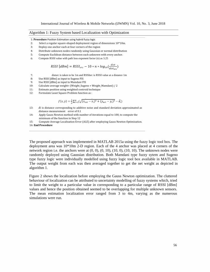
3. A HYBRID FUZZY SYSTEM BASED LOCALIZATION WITH OPTIMIZATION This section summarizes the work proposed by the Abhishek Kumar et al. and presented in [1].
The study comprised of five rule-set based hybrid fuzzy inference system modelled using
combination of both Mamdani fuzzy logic and Sugeno fuzzy logic. RSSI was fed as input in
hybrid fuzzy system and weight was obtained as output. The weight reflected the farness or
nearness of an anchor with respect to unknown sensor node. It is worth mentioning that there
exists a trade-off between number of rules formed and performance in terms of localization
accuracy. Prima facie and empirical studies conducted through experiments suggested that with
increase in number of rules and membership functions in the fuzzy logic, more fine grained
results could be obtained and accuracy could be improved. However, that also puts memory
burden on already resource constrained sensor nodes. This study attempts to achieve better
accuracy with lesser number of rules and membership functions. The rule set used for this study
is as follows:
Table 1: RSSI vs Weight Rule set
RSSI Weight
Rule 1 Very_Low Very_Low
Rule 2 Low Low
Rule 3 Medium Medium
Rule 4 High High
Rule 5 Very_High Very_High
International Journal of Wireless & Mobile Networks (IJWMN) Vol. 10, No. 3, June 2018
56
Algorithm 1: Fuzzy System based Localization with Optimization
1: Procedure Position Estimation using hybrid fuzzy logic 2: Select a regular square-shaped deployment region of dimensions 10*10m.
3: Deploy one anchor each at four corners of the region
4: Distribute unknown nodes randomly using Gaussian or normal distribution 5: Compute Euclidean distance between each unknown with every anchor. 6: Compute RSSI value with path loss exponent factor (n) as 3.25
7: distsrc is taken to be 1m and RSSIsrc is RSSI value at a distance 1m
8: Use RSSI [dBm] as input to Sugeno FIS
9: 10:
Use RSSI [dBm] as input to Mamdani FIS
Calculate average weight= (Weight_Sugeno + Weight_Mamdani) / 2
11: Estimate position using weighted centroid technique 12: Formulate Least Square Problem function as :
13: 𝑑 ̃𝑖 is distance corresponding to additive noise and standard deviation approximated as
distance measurement error of 0.1
14: Apply Gauss Newton method with number of iterations equal to 100, to compute the
minimum of the function in Step 12 15: Compute Average Localization Error (ALE) after employing Gauss Newton Optimization.
16: End Procedure
The proposed approach was implemented in MATLAB 2015a using the fuzzy logic tool box. The
deployment area was 10*10m 2-D region. Each of the 4 anchor was placed at 4 corners of the
network region i.e. the anchors were at (0, 0), (0, 10), (10, 0), (10, 10). The unknown nodes were
randomly deployed using Gaussian distribution. Both Mamdani type fuzzy sytem and Sugeno
type fuzzy logic were individually modelled using fuzzy logic tool box available in MATLAB.
The output weight from each was then averaged together to get the net weight as depicted in
algorithm 1.
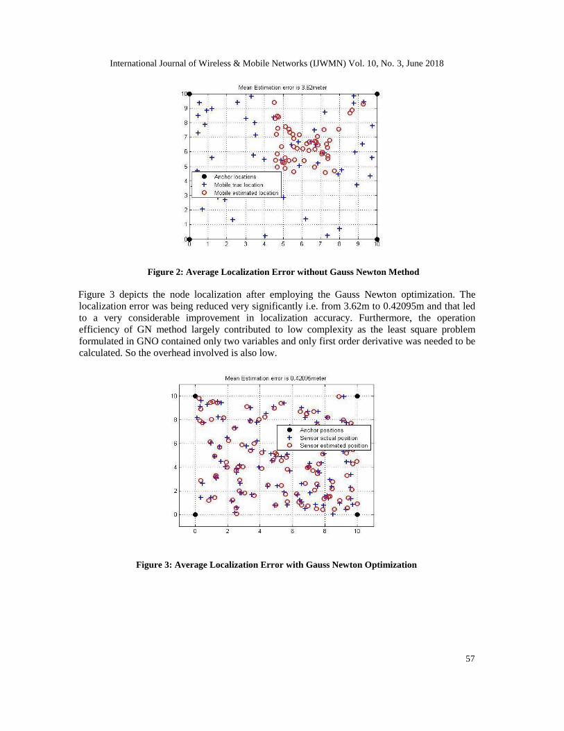
Figure 2 shows the localization before employing the Gauss Newton optimization. The cluttered
behaviour of localization can be attributed to uncertainty modelling of fuzzy systems which, tried
to limit the weight to a particular value in corresponding to a particular range of RSSI [dBm]
values and hence the position obtained seemed to be overlapping for multiple unknown sensors.
The mean estimation localization error ranged from 3 to 4m, varying as the numerous
simulations were run.
International Journal of Wireless & Mobile Networks (IJWMN) Vol. 10, No. 3, June 2018
57
Figure 2: Average Localization Error without Gauss Newton Method
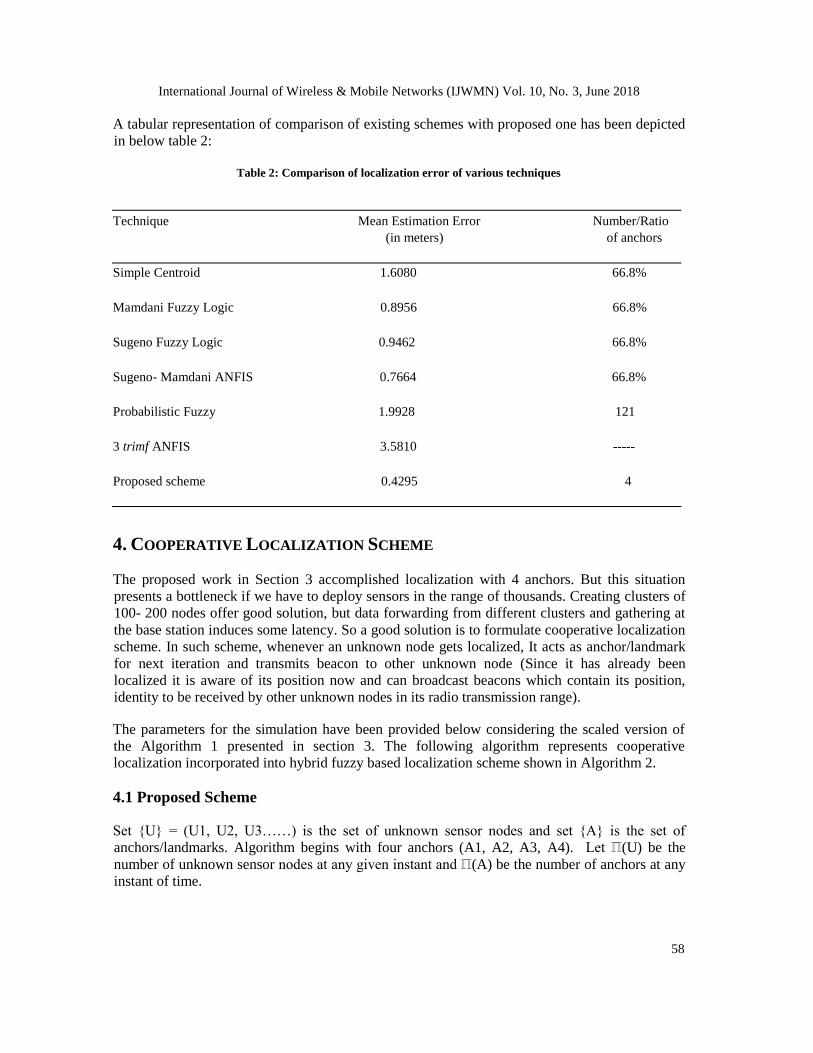
Figure 3 depicts the node localization after employing the Gauss Newton optimization. The
localization error was being reduced very significantly i.e. from 3.62m to 0.42095m and that led
to a very considerable improvement in localization accuracy. Furthermore, the operation
efficiency of GN method largely contributed to low complexity as the least square problem
formulated in GNO contained only two variables and only first order derivative was needed to be
calculated. So the overhead involved is also low.
Figure 3: Average Localization Error with Gauss Newton Optimization
International Journal of Wireless & Mobile Networks (IJWMN) Vol. 10, No. 3, June 2018
58
A tabular representation of comparison of existing schemes with proposed one has been depicted
in below table 2:
Table 2: Comparison of localization error of various techniques
Technique Mean Estimation Error Number/Ratio (in meters) of anchors
Simple Centroid 1.6080 66.8%
Mamdani Fuzzy Logic 0.8956 66.8%
Sugeno Fuzzy Logic 0.9462 66.8%
Sugeno- Mamdani ANFIS 0.7664 66.8%
Probabilistic Fuzzy 1.9928 121
3 trimf ANFIS 3.5810 -----
Proposed scheme 0.4295 4
4. COOPERATIVE LOCALIZATION SCHEME
The proposed work in Section 3 accomplished localization with 4 anchors. But this situation
presents a bottleneck if we have to deploy sensors in the range of thousands. Creating clusters of
100- 200 nodes offer good solution, but data forwarding from different clusters and gathering at
the base station induces some latency. So a good solution is to formulate cooperative localization
scheme. In such scheme, whenever an unknown node gets localized, It acts as anchor/landmark
for next iteration and transmits beacon to other unknown node (Since it has already been
localized it is aware of its position now and can broadcast beacons which contain its position,
identity to be received by other unknown nodes in its radio transmission range).
The parameters for the simulation have been provided below considering the scaled version of
the Algorithm 1 presented in section 3. The following algorithm represents cooperative
localization incorporated into hybrid fuzzy based localization scheme shown in Algorithm 2.
4.1 Proposed Scheme
Set {U} = (U1, U2, U3……) is the set of unknown sensor nodes and set {A} is the set of
anchors/landmarks. Algorithm begins with four anchors (A1, A2, A3, A4). Let ℿ(U) be the
number of unknown sensor nodes at any given instant and ℿ(A) be the number of anchors at any
instant of time.
International Journal of Wireless & Mobile Networks (IJWMN) Vol. 10, No. 3, June 2018
59
Table 3. Simulation Parameters
Number of Unknown Sensor nodes {U} = 500 Deployment region = 100×100 m2 Radio range= 10m Mode of node deployment: Randomly deployed Topology: Regular Square shaped Initial number of Anchors {A}: 4 Mode of communication: Time Division Multiplexing (TDM)
Below is the algorithm for cooperative localization. Observe that algorithm given in section 3
serves as primitive localization algorithm for the deployment.
Algorithm 2: Cooperative Localization
1: Routine Position Estimation with Cooperative Scheme
2: Input:- Set {U} of unknown sensor nodes 3: Set {A}= {A1,A2,A3,A4} of known anchors 4: Run Step 1 to 11 of Algorithm 1 5: Assume ∆ is the number of unknown sensors localized in Step 4. 6: ℿ(A)= ℿ(A)+∆
7: ℿ(U)= ℿ(U)-∆
8: for i= 1 to ∆
9: 10:
do
Add Ui ( 1≤ i≤ ∆) to {A}
11: Remove Ui (1≤i≤∆) from {U} 12: End for 13: Update {A}
14: Update {U} 15: Repeat step 1 to 14 till {U} = ɸ, ℿ(U)= 0. (This means all the unknown sensor nodes has
been successfully localized and have become anchors)
16: Run Step 12 to 15 of algorithm 1 to optimize the localization accuracy using Gauss
Newton Optimization. 17: End Algorithm 1 18: End routine
4.2 Results and Discussion
The algorithm proposed and implemented in Section 3 considered 100 nodes deployed in area of
10×10 m2. The above algorithm extends and scales the proposed scheme in Section 3 to a
network of 500 nodes deployed in a region of 100×100 m2. We implemented the Algorithm. 2 to
achieve the cooperative localization. The localization accuracy was then optimized using Gauss
Newton Method by formulating the least square problem as shown and implemented in
Algorithm. 1. The following results were observed after implementing the aforementioned
algorithm as per set parameters:
International Journal of Wireless & Mobile Networks (IJWMN) Vol. 10, No. 3, June 2018
60
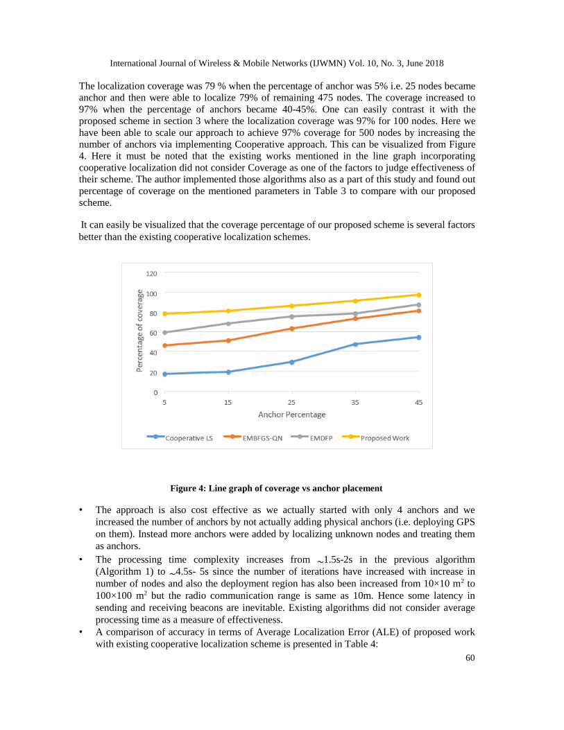
The localization coverage was 79 % when the percentage of anchor was 5% i.e. 25 nodes became
anchor and then were able to localize 79% of remaining 475 nodes. The coverage increased to
97% when the percentage of anchors became 40-45%. One can easily contrast it with the
proposed scheme in section 3 where the localization coverage was 97% for 100 nodes. Here we
have been able to scale our approach to achieve 97% coverage for 500 nodes by increasing the
number of anchors via implementing Cooperative approach. This can be visualized from Figure
4. Here it must be noted that the existing works mentioned in the line graph incorporating
cooperative localization did not consider Coverage as one of the factors to judge effectiveness of
their scheme. The author implemented those algorithms also as a part of this study and found out
percentage of coverage on the mentioned parameters in Table 3 to compare with our proposed
scheme.
It can easily be visualized that the coverage percentage of our proposed scheme is several factors
better than the existing cooperative localization schemes.
Figure 4: Line graph of coverage vs anchor placement
• The approach is also cost effective as we actually started with only 4 anchors and we
increased the number of anchors by not actually adding physical anchors (i.e. deploying GPS
on them). Instead more anchors were added by localizing unknown nodes and treating them
as anchors.
• The processing time complexity increases from 1.5s-2s in the previous algorithm
(Algorithm 1) to 4.5s- 5s since the number of iterations have increased with increase in
number of nodes and also the deployment region has also been increased from 10×10 m2 to
100×100 m2 but the radio communication range is same as 10m. Hence some latency in
sending and receiving beacons are inevitable. Existing algorithms did not consider average
processing time as a measure of effectiveness.
• A comparison of accuracy in terms of Average Localization Error (ALE) of proposed work
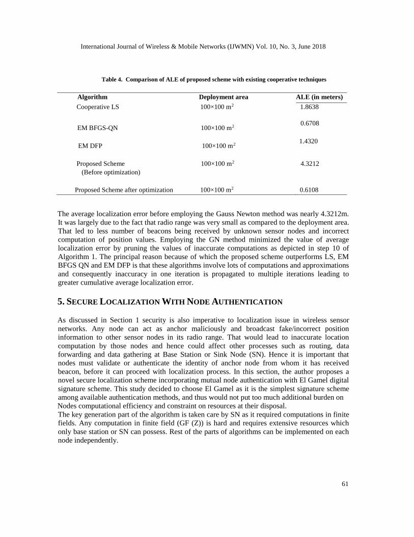
with existing cooperative localization scheme is presented in Table 4:
International Journal of Wireless & Mobile Networks (IJWMN) Vol. 10, No. 3, June 2018
61
Table 4. Comparison of ALE of proposed scheme with existing cooperative techniques
Algorithm Deployment area ALE (in meters)
Cooperative LS 100×100 m2 1.8638
EM BFGS-QN 100×100 m2 0.6708
EM DFP 100×100 m2 1.4320
Proposed Scheme 100×100 m2 4.3212
(Before optimization)
Proposed Scheme after optimization 100×100 m2 0.6108
The average localization error before employing the Gauss Newton method was nearly 4.3212m.
It was largely due to the fact that radio range was very small as compared to the deployment area.
That led to less number of beacons being received by unknown sensor nodes and incorrect
computation of position values. Employing the GN method minimized the value of average
localization error by pruning the values of inaccurate computations as depicted in step 10 of
Algorithm 1. The principal reason because of which the proposed scheme outperforms LS, EM
BFGS QN and EM DFP is that these algorithms involve lots of computations and approximations
and consequently inaccuracy in one iteration is propagated to multiple iterations leading to
greater cumulative average localization error.
5. SECURE LOCALIZATION WITH NODE AUTHENTICATION
As discussed in Section 1 security is also imperative to localization issue in wireless sensor
networks. Any node can act as anchor maliciously and broadcast fake/incorrect position
information to other sensor nodes in its radio range. That would lead to inaccurate location
computation by those nodes and hence could affect other processes such as routing, data
forwarding and data gathering at Base Station or Sink Node (SN). Hence it is important that
nodes must validate or authenticate the identity of anchor node from whom it has received
beacon, before it can proceed with localization process. In this section, the author proposes a
novel secure localization scheme incorporating mutual node authentication with El Gamel digital
signature scheme. This study decided to choose El Gamel as it is the simplest signature scheme
among available authentication methods, and thus would not put too much additional burden on
Nodes computational efficiency and constraint on resources at their disposal.
The key generation part of the algorithm is taken care by SN as it required computations in finite
fields. Any computation in finite field (GF (Z)) is hard and requires extensive resources which
only base station or SN can possess. Rest of the parts of algorithms can be implemented on each
node independently.
International Journal of Wireless & Mobile Networks (IJWMN) Vol. 10, No. 3, June 2018
62
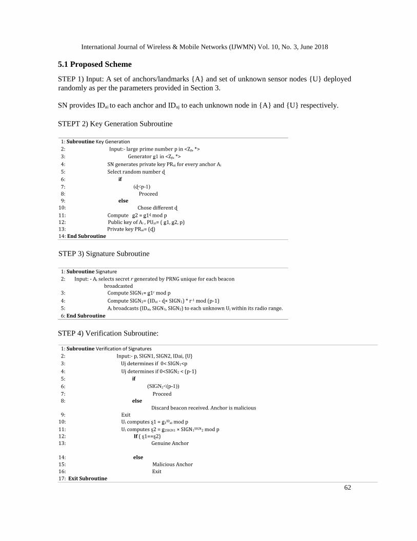
5.1 Proposed Scheme
STEP 1) Input: A set of anchors/landmarks {A} and set of unknown sensor nodes {U} deployed
randomly as per the parameters provided in Section 3.
SN provides IDai to each anchor and IDuj to each unknown node in {A} and {U} respectively.
STEPT 2) Key Generation Subroutine
1: Subroutine Key Generation
2: Input:- large prime number p in <Zp, *> 3: Generator ǥ1 in <Zp, *> 4: SN generates private key PRai for every anchor Ai
5: Select random number ɖ 6: if
7: (ɖ<p-1)
8: Proceed
9: 10:
else
Chose different ɖ
11: Compute ǥ2 = ǥ1ɖ mod p 12: Public key of Ai , PUai= ( ǥ1, ǥ2, p) 13: Private key PRai= (ɖ)
14: End Subroutine
STEP 3) Signature Subroutine
1: Subroutine Signature
2: Input: - Ai selects secret r generated by PRNG unique for each beacon
broadcasted 3: Compute SIGN1= ǥ1r mod p
4: Compute SIGN2= (IDai - ɖ× SIGN1) * r-1 mod (p-1)
5: Ai broadcasts (IDai, SIGN1, SIGN2) to each unknown Uj within its radio range. 6: End Subroutine
STEP 4) Verification Subroutine:
1: Subroutine Verification of Signatures 2: Input:- p, SIGN1, SIGN2, IDai, {U}
3: Uj determines if 0< SIGN1<p 4: Uj determines if 0<SIGN2 < (p-1)
5: if 6: (SIGN2<(p-1))
7: Proceed
8: else
Discard beacon received. Anchor is malicious
9: 10:
Exit
Ui computes ȿ1 = ǥ1IDai mod p
11: Ui computes ȿ2 = ǥ2SIGN1 × SIGN1SIGN2 mod p 12: If ( ȿ1==ȿ2) 13: Genuine Anchor
14: else
15: Malicious Anchor
16: Exit
17: Exit Subroutine
International Journal of Wireless & Mobile Networks (IJWMN) Vol. 10, No. 3, June 2018
63
After the signature verification is complete, unknown sensor node is assured that the beacon it
received was from a genuine anchor in the deployment area. It can then proceed with localization
process by employing the Algorithm 2.
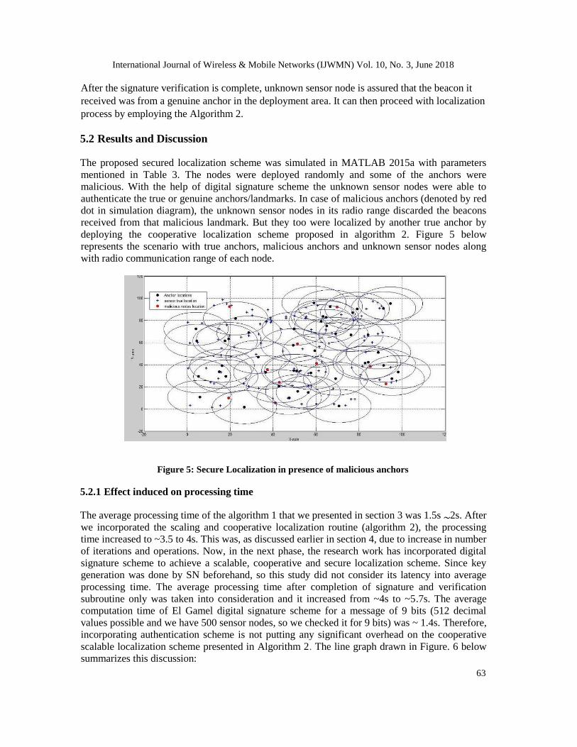
5.2 Results and Discussion
The proposed secured localization scheme was simulated in MATLAB 2015a with parameters
mentioned in Table 3. The nodes were deployed randomly and some of the anchors were
malicious. With the help of digital signature scheme the unknown sensor nodes were able to
authenticate the true or genuine anchors/landmarks. In case of malicious anchors (denoted by red
dot in simulation diagram), the unknown sensor nodes in its radio range discarded the beacons
received from that malicious landmark. But they too were localized by another true anchor by
deploying the cooperative localization scheme proposed in algorithm 2. Figure 5 below
represents the scenario with true anchors, malicious anchors and unknown sensor nodes along
with radio communication range of each node.
Figure 5: Secure Localization in presence of malicious anchors
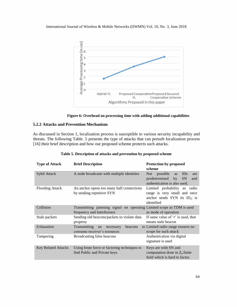
5.2.1 Effect induced on processing time The average processing time of the algorithm 1 that we presented in section 3 was 1.5s 2s. After
we incorporated the scaling and cooperative localization routine (algorithm 2), the processing
time increased to ~3.5 to 4s. This was, as discussed earlier in section 4, due to increase in number
of iterations and operations. Now, in the next phase, the research work has incorporated digital
signature scheme to achieve a scalable, cooperative and secure localization scheme. Since key
generation was done by SN beforehand, so this study did not consider its latency into average
processing time. The average processing time after completion of signature and verification
subroutine only was taken into consideration and it increased from ~4s to ~5.7s. The average
computation time of El Gamel digital signature scheme for a message of 9 bits (512 decimal
values possible and we have 500 sensor nodes, so we checked it for 9 bits) was ~ 1.4s. Therefore,
incorporating authentication scheme is not putting any significant overhead on the cooperative
scalable localization scheme presented in Algorithm 2. The line graph drawn in Figure. 6 below
summarizes this discussion:
International Journal of Wireless & Mobile Networks (IJWMN) Vol. 10, No. 3, June 2018
64
Figure 6: Overhead on processing time with adding additional capabilities
5.2.2 Attacks and Prevention Mechanism As discussed in Section 1, localization process is susceptible to various security incapability and
threats. The following Table. 5 presents the type of attacks that can perturb localization process
[16] their brief description and how our proposed scheme protects such attacks.
Table 5. Description of attacks and prevention by proposed scheme
Type of Attack Brief Description Protection by proposed
scheme
Sybil Attack A node broadcasts with multiple identities Not possible as IDs are
predetermined by SN and
authentication is also used. Flooding Attack An anchor opens too many half connections
by sending repetitive SYN Limited probability as radio
range is very small and once
anchor sends SYN its IDai is
identified Collision Transmitting jamming signal on operating
frequency and Interference Limited scope as TDM is used
as mode of operation Stale packets Sending old beacons/packets to violate data
property If same value of ‘r’ is used, that
means stale beacon Exhaustion Transmitting un necessary beacons to
consume receiver’s resources Limited radio range ensures no
scope for such attack Tampering Broadcasting false beacons Authentication via digital
signature is used
Key Related Attacks Using brute force or factoring techniques to
find Public and Private keys Keys are with SN and
computation done in Zp finite
field which is hard to factor.
International Journal of Wireless & Mobile Networks (IJWMN) Vol. 10, No. 3, June 2018
65
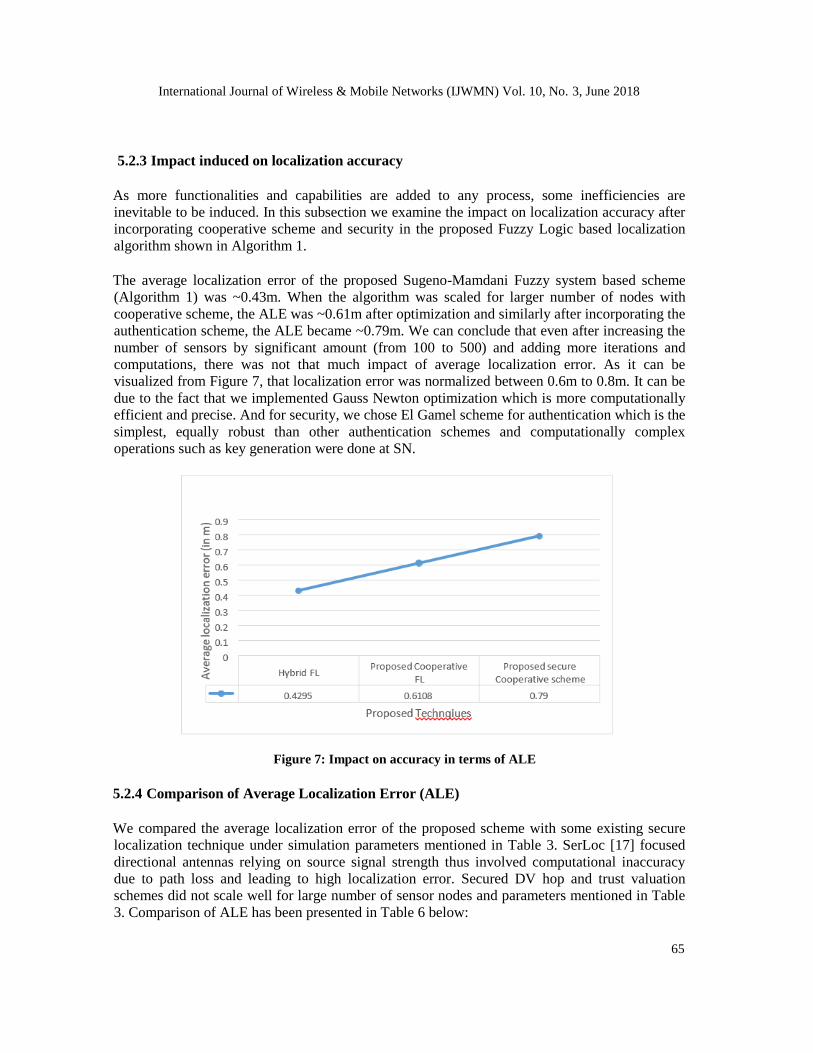
5.2.3 Impact induced on localization accuracy
As more functionalities and capabilities are added to any process, some inefficiencies are
inevitable to be induced. In this subsection we examine the impact on localization accuracy after
incorporating cooperative scheme and security in the proposed Fuzzy Logic based localization
algorithm shown in Algorithm 1.
The average localization error of the proposed Sugeno-Mamdani Fuzzy system based scheme
(Algorithm 1) was ~0.43m. When the algorithm was scaled for larger number of nodes with
cooperative scheme, the ALE was ~0.61m after optimization and similarly after incorporating the
authentication scheme, the ALE became ~0.79m. We can conclude that even after increasing the
number of sensors by significant amount (from 100 to 500) and adding more iterations and
computations, there was not that much impact of average localization error. As it can be
visualized from Figure 7, that localization error was normalized between 0.6m to 0.8m. It can be
due to the fact that we implemented Gauss Newton optimization which is more computationally
efficient and precise. And for security, we chose El Gamel scheme for authentication which is the
simplest, equally robust than other authentication schemes and computationally complex
operations such as key generation were done at SN.
Figure 7: Impact on accuracy in terms of ALE
5.2.4 Comparison of Average Localization Error (ALE)
We compared the average localization error of the proposed scheme with some existing secure
localization technique under simulation parameters mentioned in Table 3. SerLoc [17] focused
directional antennas relying on source signal strength thus involved computational inaccuracy
due to path loss and leading to high localization error. Secured DV hop and trust valuation
schemes did not scale well for large number of sensor nodes and parameters mentioned in Table
3. Comparison of ALE has been presented in Table 6 below:
International Journal of Wireless & Mobile Networks (IJWMN) Vol. 10, No. 3, June 2018
66
Table 6. Comparison of localization error of various schemes
Algorithm Average Localization Error (in Meters)
SeRLoC ~1.45
Secured DV hop ~0.9
Trust valuation based scheme ~1.2 Proposed scheme ~0.79
6. CONCLUSION AND FUTURE RESEARCH DIRECTIONS
Localization often requires modelling of the network which is a non-deterministic problem. The
study done in this paper, attempted to tackle localization issue by modelling the network in to
fuzzy logic systems, since fuzzy systems are apt at handling uncertainties. Results obtained were
then optimized to ascertain better accuracy. Furthermore, a scalable cooperative scheme was
proposed to offer a cost effective solution for large networks with greater number of node.
Security was incorporated by adding an authenticated scheme so that unknown sensor nodes can
differentiate between true and malicious anchors. Various parameters to judge the scheme such
as localization accuracy, time complexity, coverage and cost were also discussed. The limitations
upon which future work can be carried out is summarized below:
• The proposed schemes consider two dimensional deployment region. Its effectiveness in
three dimensional deployment plane must be assessed. It would provide a real world
emulation scenario.
• The anchors and unknown sensor nodes were assumed to be static. A mobility situation can
be modeled where either or both the anchor and unknown nodes are mobile.
• Most of the localization algorithms consider regular deployment region with Line of Sight
(LoS) communication. In real world, sensors are often deployed in irregular terrains.
Modelling such networks are very difficult and rife with computational inaccuracies. The
existing works must be assessed against irregular deployment regions where topology is not
square shaped but rather S and C shaped.
• Underground acoustics sensor networks are the future of sensor networks. These networks
are more resource constrained than conventional wireless sensor networks. An efficient and
accurate position determination system must be designed that offer cost effective solution
with lower computational complexity.
• Future work can also be done to unify other issues such as Media access, energy
conservation and dynamic routing into localization process to come up with one single
solution that can be deployed on sensors.
• Predictive analytics techniques using machine learning and reinforcement learning with
neural networks can be studied to model the sensor networks efficiently. Such solutions
could come handy for underground sensor networks and networks with irregular deployment.
International Journal of Wireless & Mobile Networks (IJWMN) Vol. 10, No. 3, June 2018
67
REFERENCES
[1] Kumar A., Saini B. (2018) A Sugeno-Mamdani Fuzzy System Based Soft Computing Approach
Towards Sensor Node Localization with Optimization. In: Bhattacharyya P., Sastry H., Marriboyina
V., Sharma R. (eds) Smart and Innovative Trends in Next Generation Computing Technologies.
NGCT 2017. Communications in Computer and Information Science, vol 828. pp 40-55, Springer,
Singapore.
[2] A. Kumar, N. Chand, V. Kumar, and V. Kumar, “Range Free Localization Schemes for Wireless
Sensor Networks,” Int. J. Comput. Networks Commun., vol. 3, no. 6, pp. 115–129, 2011.
[3] A. Kumar and V. Kumar, “Fuzzy Logic Based Improved Range Free Localization for Wireless
Sensor Networks,” vol. 177005, no. 5, pp. 534–542, 2013.
[4] M. A. Monfared, “Range Free Localization of Wireless Sensor Networks Based on Sugeno Fuzzy
Inference,” no. c, pp. 36–41, 2012.
[5] S. K. Gharghan, R. Nordin, and M. Ismail, “A wireless sensor network with soft computing
localization techniques for track cycling applications,” Sensors (Switzerland), vol. 16, no. 8, 2016.
[6] M. Kadkhoda, M. A. Totounchi, S. Member, M. H. Yaghmaee, and Z. Davarzani, “A Probabilistic
Fuzzy Approach for Sensor Location Estimation in Wireless Sensor Networks,” 2010.
[7] L. Mallu and R. Ezhilarasie, “Live migration of virtual machines in cloud environment: A survey,”
Indian J. Sci. Technol., vol. 8, no. July, pp. 326–332, 2015.
[8] B. Li, N. Wu, H. Wang, P. H. Tseng, and J. Kuang, “Gaussian message passing-based cooperative
localization on factor graph in wireless networks,” Signal Processing, vol. 111, no. April, pp. 1–12,
2015.
[9] H. Naseri and V. Koivunen, “A Bayesian algorithm for distributed network localization using
distance and direction data,” pp. 1–11.
[10] Tashnim Jabir Shovon Chowdhury, “A Distributed Cooperative Algorithm for Localization in
Wireless Sensor Networks Using Gaussian Mixture Modeling,” University of Toledo, 2016.
[11] Kumar A., Prashar D. (2018) A Novel Approach for Node Localization in Wireless Sensor
Networks. In: Singh R., Choudhury S., Gehlot A. (eds) Intelligent Communication, Control and
Devices. Advances in Intelligent Systems and Computing, vol 624. pp 419-428, Springer, Singapore
[12] X. Liu, R. Yang, and Q. Cui, “An Efficient Secure DV-Hop Localization for Wireless Sensor
Network,” System, vol. 9, no. 7, pp. 275–284, 2015.
[13] H. Chen, W. Lou, Z. Wang, J. Wu, Z. Wang, and A. Xi, “Securing DV-Hop localization against
wormhole attacks in wireless sensor networks,” Pervasive Mob. Comput., vol. 16, no. PA, pp. 22–
35, 2015.
[14] W. Shi, M. Barbeau, J. P. Corriveau, J. Garcia-Alfaro, and M. Yao, “Secure localization in the
presence of colluders in WSNs,” Sensors (Switzerland), vol. 17, no. 8, 2017.
[15] P. Li, X. Yu, H. Xu, J. Qian, L. Dong, and H. Nie, “Research on secure localization model based on
trust valuation in wireless sensor networks,” Secur. Commun. Networks, vol. 2017, 2017.
International Journal of Wireless & Mobile Networks (IJWMN) Vol. 10, No. 3, June 2018
68
[16] G. Kumar, M. K. Rai, H. J. Kim, and R. Saha, “A Secure Localization Approach Using Mutual
Authentication and Insider Node Validation in Wireless Sensor Networks,” Mob. Inf. Syst., vol.
2017, 2017.
[17] L. Lazos and R. Poovendran, “SeRLoc: Secure Range-Independent Localization for Wireless Sensor
Networks,” Netw. Secur., pp. 21–30, 2004.


![Comparison of Fuzzy logic, AHP, FAHP and Hybrid Fuzzy AHP … · 2014-08-21 · [Post-print version] Please cite as: Alessio Ishizaka, Comparison of Fuzzy logic, AHP, FAHP and Hybrid](https://img.pdfslide.us/doc/110x75/5cd53a2d88c993f06f8be8e1/comparison-of-fuzzy-logic-ahp-fahp-and-hybrid-fuzzy-ahp-2014-08-21-post-print.jpg)