Embed Size (px)
Citation preview
A FIELDTRIP EXCURSION
Geology and Energy Resourcesof the Triassic Basinsof Northern Virginia
Old mines and geology of the Richmond Basin
Excursion Guides
Robert C. Milici U.S. Geological Survey
Reston, VA 20192
and
Gerald P. Wilkes Virginia Division of Mineral Resources
Charlottesville, VA 22903
Washington, D.C. Area September 24, 2003

Geology and Energy Resources of the Triassic Basins of Northern Virginia
Old mines and geology of the Richmond Basin
A field excursion prepared for the 20th Annual Meeting of The Society for Organic Petrology
September 24, 2003
Excursion Guides
Robert C. Milici U.S. Geological Survey Reston, Virginia 20192
And
Gerald P. Wilkes Virginia Division of Mineral Resources
Charlottesville, Virginia 22903
2

CONTENTS
Introduction
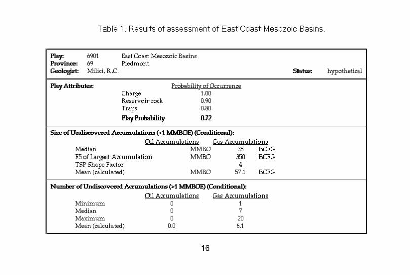
“The East Coast Mesozoic Play (Hypothetical),” from the USGS 1995 National Assessment of United States Oil and Gas Resources.
Road Log
“The methane potential from coal seams in the Richmond Basin of Virginia,” prepared by the Department of Mining and Minerals Engineering, Virginia Polytechnic Institute and State University.
Forward Summary
Guidebook to the Geology of the Richmond and Taylorsville Basins, East Central Virginia, by Goodwin, B. K., Weems, R. E., Wilkes, G. P., Froelich, A. J., and Smoot, J. P., 1985, Guidebook for the eastern section AAPG meeting Fieldtrip no. 4, 60 p.
3

INTRODUCTION
The field excursion to the Richmond Triassic Basin, near Richmond, Virginia (fig. 1) will visit five localities: Stop 1 – Old mines in woods at Manakin; Stop 2 – Boscobel Quarry near the James River, Stop 3 – Abandoned sandstone quarry at Tuckahoe Plantation (Lunch Stop), Stop 4 - Grove Shaft and old mine workings at Midlothian, and Stop 5 – Subsidence featuresand old railroad track along U.S. Highway 250 near Gaskins (fig. 2). Rather than a single guidebook, the trip will rely on field trip stop descriptions previously published within Goodwin and others (1985), and descriptions of the old mining districts published by Wilkes (1988). These publications will be supplemented with data from Roberts (1928), and from the 1995 USGS National Oil and Gas Assessment (Milici, 1996). Field trip participants are invited to discuss their research interests in the eastern Mesozoic Basins.
The trip will leave the Hyatt Arlington Hotel (meeting in lobby) at approximately 7:30 AM and return at about 6:00 PM, depending on the famous I-95 traffic. Physical access to the stops is relatively easy, and some walking is required. Hard hats are required, and will be provided. The weather is expected to be mild. However, check on the weather forecast and bring rain gear, if appropriate. You may wish to use insect repellant for chiggers and ticks.
References
Dullaghan, E.M., and R. Venkatakrishnan, 1988. Example of Extensional Style Deformation in the richmond Triassic Basin, Virginia: Geological Society of America Abstracts with Programs, Vol. 20, No. 4, p. 261.
Goodwin, B. K., Weems, R. E., Wilkes, G. P., Froelich, A. J., and Smoot, J. P., 1985, Guidebook to the geology of the Richmond and Taylorsville basins, east-central Virginia. Guidebook for the eastern section AAPG meeting Fieldtrip no. 4, 60 p.
Milici, R.C., 1996, Blue Ridge thrust belt (068), Piedmont Province (069), Atlantic Coastal Plain Province (070), Adirondack Province (071), and New England Province (072), in Gautier, D. L., Dolton, G. L., Takahashi, K. I., and Varnes, K. L., eds., 1996, 1995 National Assessment of United States oil and gas resources – Results, methodology, and supporting data: U.S. Geological Survey Digital Data Series DDS-30, Release 2, 39 p.
Roberts, J.K., 1928, The geology of the Virgin ia Triassic: Virginia Geological Survey Bulletin 29, 205 p.
Wilkes, G. P., 1988, Mining history of the Ri chmond coal field of Virginia: Virginia Division of Mineral Resources Publication 85, 51 p.
4

Goo
chla
nd
Ric
hmon
dP
owha
tan
Che
ster
field
Hen
rico
New
Ken
t
Han
over
Tay
lors
ville
B
asin
Mes
ozoi
c B
asin
s (e
xpos
ed)
N
E
S
W
DR
(Inf
erre
d)
Ric
hmon
d B
asin
Sco
ttsvi
lle
Bas
in Far
mvi
lle
Bas
in
5
40�
� �
0�
� �
40
� �
� 8
0 M
iles
Fig
ure
1. C
entr
al V
irgin
ia M
esoz
oic
basi
ns, w
ith n
ames
of
� R
ichm
ond-
area
cou
ntie
s. D
R -
- D
eep
Run
Bas
in.

N
EW
S
Mesozoic Basins
Goochland
Henrico
Powhatan
Amelia Chesterfield
Richmond
X
X
X X
X Stop 5
Stop 1
Stop 2 Stop 3
Stop 4
x Stop 1
x Stop 2
x Stop 3
x Stop 4
x Stop 5
20� � � � � � 0� � � � � � 20 Miles�
Figure 2. General location of field trip stops in Richmond Basin. Road map is from � 2002-2004 Virginia Official State Transportation Map.
6

THE EAST COAST MESOZOIC BASIN PLAY (HYPOTHETICAL)
By
Robert C. Milici U.S. Geological Survey
Reston, VA 20192
This section is extracted and condensed from Milici (1996) in Gautier and others (1996).
The eastern part of the North American continent contains several dozen Mesozoic extensional basins that are distributed onshore (fig. 3) from Florida northward to Nova Scotia, and offshore from the Blake Plateau to Georges Bank. In general, the onshore basins are situated within the Precambrian to Paleozoic rocks of the Piedmont and Blue Ridge and to a much lesser extent within Paleozoic strata along the western Piedmont margin in Maryland and southern Pennsylvania. The East Coast Mesozoic Basins Play extends from beneath the Atlantic Coastal Plain in northern Florida, Alabama, and Georgia, northeastward along the Atlantic coastal margin to southern New England. The play occurs in parts of four distinct provinces, the Piedmont, Blue Ridge, Atlantic Coastal Plain, and New England provinces, and extends eastward onto the outer continental shelf. In general, the play is bounded, in part, by the Blue Ridge Thrust Belt and Appalachian Basin Provinces on the west, and by the 3-mile limit of State waters on the east. The East Coast Mesozoic Basins Play occupies an area of about 113,000 sq mi, approximately 900 miles long and 100-140 miles wide (fig. 3).
The East Coast Mesozoic Basins are assessed collectively as a single play that extends over parts of four provinces. Schultz (1988) described the onshore basins for the previous l989 assessment. This present assessment is concerned with the potential undiscovered oil and gas resources of the onshore basins and of the offshore basins within the 3-mile limit. It should be noted, however, that almost all of the offshore basins are beyond the 3-mile limit.
In general, the east coast Mesozoic basins range in size from 190 sq mi or less to 19,000 sq mi or more. The exposed onshore basins, approximately 30 in number (Luttrell, 1989), occur chiefly within the Piedmont physiographic province, generally from Virginia southward into the Carolinas. To the north, in Maryland and Pennsylvania, Mesozoic basins interrupt the physiographic expression of the more mountainous Blue Ridge and extend northeastward into the highlands of New England. Other basins occur widespread in the Atlantic Coastal Plain physiographic province, where they are buried beneath younger Mesozoic and Cenozoic strata at depths ranging from a few to several thousand feet (Benson 1992; Hansom 1988, Milici and others, 1991), Parts of the South Georgia
7

Basin extend beneath the Atlantic Coastal Plain into the Gulf Coastal Plain in northern Florida (Chowns and Williams,1983), Similar rift-related structures occur offshore on the Continental Shelf, where they have been imaged beneath the post-rift unconformity by regional and detailed seismic surveys. These structures include the Norfolk Basin offshore of southwestern Virginia, and the Fenwick Basin offshore of Delaware (for example, see Bayer, 1987 and Bayer and Milici, 1987, Benson and others, 1986, Benson, 1992).
In general these basins formed along the continental margin in response to the regional uplift, extension, and crustal thinning that occurred during the mid -Triassic opening of the Atlantic Ocean. The basins began to form about 227 million years ago, in middle Carnian (Late Triassic) time (Manspeizer and Cousminer, 1988) along the newly formed continental margins. This Mesozoic rifting lasted for only a relatively short period of time and ended early in the Jurassic approximately concurrent with large-scale regional vulcanism, intrusion of diabase, and extrusion of basalt,
Contemporaneous with rifting, the basins were filled with a variety of continental siliciclastics ranging from very-coarse boulder beds and arkosic sandstones along the basin margins, to red siltstones, mudstones, and very fine-grained gray and black lake deposits that were deposited in diverse fluvial-lacustrine environments within basin interiors. In general, the basin infilling appears to have occurred in a mountainous tropical rain forest setting of considerable local relief (see Luttrell, 1989 for a summary; Cornett and Olsen 1990). Basins buried beneath the Atlantic Coastal Plain and on the North American Continental Shelf are separated from overlying younger deposits by a pronounced unconformity, the post-rift unconformity (Schlee and Klitgord, 1986), which marks approximately 100 million years of erosion and beveling of the pre-existing early Mesozoic topography prior to deposition of Cretaceous coastal plain sediments. This unconformity is of regional extent and has been traced throughout the seismic network that covers much of the Atlantic outer continental shelf (Klitgord, 1981).
Most of the Mesozoic basins are faulted along their western margins by east-dipping faults, and their hanging walls have moved downward relatively to the east during basin extension and filling. West-dipping faults, although not uncommon, are generally subsidiary to the eastward -dipping master set. This extensional deformation occurred coincidentally with sedimentation and basin fill, so that the first formed deposits were deformed progressively as the basin widened. The extension, thus, not only enhanced the development of fracture porosity, especially in the older Mesozoic rocks, but also resulted in some folding of the strata within the basins and thereby formed structural traps; in places extensional deformation most certainly reduced the effectiveness of available seals.
Reservoirs: Potential reservoir rocks encompass a variety of lithologies that range from very coarse alluvial fan deposits, "fanglomerates," to fluvial and deltaic deposits that were deposited along basin margins and interfinger with adjacent finer-grained lake deposits. Because of the great amount of local relief that existed in places along faulted basin margins, deposition of these coarser grained deposits took place very rapidly so that
8

great thicknesses of sediments accumulated with little or no chance for reworking by the agencies of wind and water. As a result, sorting is commonly poor and the porosity between sandstone grains is commonly clogged with finer-grained siliciclastics. In contrast, deltaic and littoral sandstones that accumulated within basin interiors may constitute some of the better reservoirs, especially where they are extensionally fractured and sealed by black shale source rocks.
Conventional core analyses from 27 sandstone samples from one well in the Richmond Basin, Virginia, yield values for porosity that range from 2.0% to 12.5%, with a median value of 8.2%. Permeability values for the same samples range from <0.01 to 18 mD, with a median of 0.61 mD. In the Deep River Basin, North Carolina, porosities are generally low and average about 3.5% (Reid and Hoffman, in preparation). Fracture porosity may be important in some places, especially in the sedimentary strata that were deposited early in basin history.
Source rocks: The better source rocks within the Mesozoic basins are the gray and black shales that generally were deposited in lakes, offshore in deeper water environments, probably during periods of high organic productivity, and perhaps under anoxic conditions. These black shale beds may range from a few feet to several hundred feet thick. Kerogen in these beds generally consists of material derived from vascular plants and algae, which, in source beds, are prone to yield both gas and oil. Thermal maturation values range widely, from within the zone of dry gas to immature with respect to liquid hydrocarbons. In the Newark and Hartford Basins, thermal maturity ranges greatly over short stratigraphic distances and reflects the effects of both regional and localized high flows of heat associated with hydrothermal alteration and diabase intrusion during the final phase of basin development in the Early Jurassic (Pratt and others, 1988).
Timing and migration of hydrocarbons: A time-temperature model for the Taylorsville Basin (Milici and others, 1991) indicates that the lower part of the Taylorsville Basin entered the zone of oil generation about 195 Ma, in the Early Jurassic. Depending on the depth of burial and heat flow for each of the basins, hydrocarbon generation and migration into local traps appears to have been initiated concurrently with extension and sedimentation late in the Triassic and continued into the Early Jurassic, when the basin extension ceased following continental breakup, separation, and the initial opening of the Atlantic Ocean.
Traps: Potential traps within the Mesozoic rift basins are likely to occur at depths ranging from about a thousand feet to almost 20,000 feet within some of the larger basins. They are likely to be formed from a combination of structural and stratigraphic features related to contemporaneous tectonic extension basin deepening, and rapid sedimentation. Deposits in the lower parts of the basin are more likely to be complexly folded and faulted than are deposits in the upper parts of basins. Roll-over antclines are likely to occur above listric faults along basin margins, areas that are likely to exhibit rapid lateral variations of coarse-grained siliciclastic rocks in short distances. In the Piedmont, metamorphic rocks are exposed within the perimeters of several Mesozoic basins, attesting to the complexity of local structure.
9
Late stage compressional structures are conspicuous features in some of the basins, to the extent that some large-scale folds exhibit a total stratigraphic thickness that exceeds present basin depths. The compressional forces that formed these larger scale folds apparently were generated as the newly formed North American continent drifted relatively eastward, away from the region of high heat flow and mantle convection that was the driving force in the disruption of the protocontinent, Pangea. Subsequently, as the continental margin cooled the recently uplifted end extended crust subsided and was compressed to fit into a lower, shorter geodesic arc, thus generating the compression that fold ad Mesozoic sediments within the basins.
Extensional faults of all dimensions occur within the basins and in some places may form updip cut offs that place potential seals against coarser-grained siliciclastic reservoir rocks. Where gray to black basinal shales are suitable mature and extensively fractured, they could constitute autogenic reservoirs for the production of natural gas.
Exploration status: Although almost all of the larger basins have had some drilling in them, either for coal, oil and gas, or both, only two of them have been seriously explored for oil and gas. These are the Richmond and Taylorsville Basins. Of the two the Richmond Basin appears to have been largely explored, whereas much area in the Taylorsville Basin beneath the Atlantic Coastal Plain remains to be tested by the drill.
The South Georgia and associated Mesozoic basins, which lie buried beneath the Atlantic Coastal Plain extend from Alabama and Florida through Georgia to South Carolina. They are known chiefly from several dozen wells that have penetrated the coastal plain cover. Although there is little specific data concerning these wells, three are shown by Chowns and Willaims (1983) to have penetrated the Early Mesozoic section and to have entered into Paleozoic rocks identified as part of the African craton.
Four wells drilled into the Durham Basin, North Carolina, exhibit multiple shows of oil and gas at depths ranging up to about 4,600 feet (Reid and Hoffman, in preparation). The shows are most commonly of natural gas and oil, with same of condensate or asphalt. Reinemund (1955) reported on the results of thirty diamond drill holes that were drilled indo the Deep River Coal Field in the Durham Basin between l9l5 and l950. Oil shales associated with the coal beds in these holes yield as much as l0 to l5 gallons of oil per ton and apparently could serve as source beds.
The Richmond Basin, Virginia, has been drilled extensively for coal, oil, and gas. Between 1897 and 1985, 38 exploratory holes were drilled in the basin (Wilkes.1988). Of the 38 holes, 22 were drilled to depths of l,000 feet or more. The deepest hole, Cornell Oil Company, No. l Bailey, entered granite basement at 7,110 feet and was drilled to a total depth of 7,438 feet. The hole encountered several coal beds, but no oil or gas. Of the remaining deep holes, 6 had shows of liquid and/ or gaseous hydrocarbons. Subsequently, industry has conducted at least two core drilling campaigns for coal along the margins of the basin during the latter part of the decade. The leases apparently were abandoned because of excessive disruption of the coal beds by faulting. The extensive
10

drilling in this relatively small basin indicates that the chances of finding significant amounts oil or gas there are minimal.
More recently, the Taylorsville Basin, Virginia, has been the subject of considerable industry interest and exploration. In 1986, Texaco, Inc. drilled 5 diamond drill core holes in the Richmond Basin each to a depth of 5,500 feet, apparently the limit of the drilling rig. A sixth hole encountered crystalline basement at about 3,533 feet, The core holes were followed in l989 by a deep test the Texaco W.B. Wilkins et ux No. 1, which was drilled into basement at a total depth of 10,135 feet. Three of the core holes and the deep test had indications of oil and gas (Milici and others, 1991). Subsequently, Texaco drilled a second deep test in Virginia. The data for this last well, at present, remain confidential on file with the Virginia Division of Gas and Oil in Abingdon.
Three wells were drilled in York County, Pennsylvania, in the early 1960's. The deepest was drilled to a depth of 8,631 feet. All were dry. A dip fence of six core holes was drilled across the Newark bash New Jersey, in the early 1990's. The holes intersected a nearly continuous 20,000 foot-thick stratigraphic section across the lower two thirds of the basin. The data for these wells are available from the Lamont-Doherty Geological Observatory, Palisades, N.Y. (Petzet, 1991).
Resource potential: Overall, resource potential is generally poor to fair because of relativity low porosity and permeability of potential Mesozoic sandstone reservoirs. Except for the Richmond Basin and perhaps for the Durham Basin, the play is largely undrilled. The basins with the greatest overall potential for hydrocarbon production apparently are the Taylorsville, and perhaps the South Georgia, and some of the offshore basins, such as the Norfolk Basin. Almost nothing is known of the internal stratigraphy and organic geochemistry of the latter two basins, however, and they were not evaluated in this study.
RICHMOND BASIN
Coal was mined from the Richmond Basin by Huguenot settlers and used locally by 1703. The coal mines proved to be excessively gassy and as a result many miners were killed by explosions in subsequent years (Wilkes, 1988). The basin has been extensively drilled both for coal, oil and gas. Much of the coal test information that was developed by industry during the 1980's remains proprietary. Wilkes (1988), however, has documented 22 oil and gas or coal tests that were drilled to depths of 1,000 feet or more into Richmond Basin rocks. Of these, 6 reported shows of oil but nothing was discovered in commercial quantities. The deepest well the Cornell Oil Company, Bailey No. 1, was drilled in 1981 and encountered basement at a depth of 7,110 ft (Wilkes, 1988).
The most likely source beds for oil in the Richmond Basin are the lacustrine gray to black shales within the Upper Triassic Vinita Beds, The Vinita Beds are about 6,000 ft thick and consist of strata that were deposited in fluvial and deltaic environments around the margins of the basin and in lacustrine environments in the basin center (Goodwin and
11
others, 1985). Robbins and others (1988), from a study of coal beds and pollen and spore colors from rocks in the Richmond Basin and the Deep Run Basin nearby, have documented that thermal maturation ranges from submature to supermature with respect to oil generation.
TAYLORSVILLE BASIN
The Taylorsville Basin, which lies almost entirely buried beneath the Atlantic Coastal Plain, has attracted considerable interest by industry during thee past several years. The exposed part of the basin has been mapped and described in detail by Weems (1980,1981,1986) and Goodwin and others (1985). The deeper parts of the basin were explored by three oil and gas tests and by six diamond drill holes cored by Texaco, Inc. Texaco's first oil and gas test, in 1989, was drilled to basement at a depth of 10,135 ft. Data from all but the last oil and gas test, as well as an interpretation of a regional vibroseis line across the basin, are presented by Milici and others (1991). Three of the core holes as well as the Texaco Wilkens et ux no. 1 oil and gas test exhibited shows of hydrocarbons, although not in commercial quantities. Palynomorphs from the exposed part of the basin have yielded TAI colors that indicate these strata are within the thermal zone of oil generation (see Milici and others, 1991 for a summary). Proprietary data from the Wilkins well indicates that there are about 200 feet of ray shale in the lower half of the well that are potentially suitable for source beds.
REFERENCES
Bayer, K. C., 1987 Geologic interpretation of offshore seismic lines, Virginia: Virginia Division of Mineral Resources Publication 73A.
Bayer, K. C., and Milici, R. C., 1987 Geology and petroleum potential of Mesozoic and Cenozoic rocks, offshore Virginia: Virginia Division of Mineral Resources Publication 73D.
Bayer, K. C., and Milici R. C., 1989, Petroleum geology of the mid-Atlantic continental margin, offshore Virginia: Marine Geology, v. 90, p, 87-94
Benson R.N., 1992, Map of exposed and buried Early Mesozoic rift basins/synrift rocks of the U.S. middle Atlantic Continental margin: Delaware Geologic Survey Miscellaneous Map Series no. 5, scale 1:1,000,000.
Benson R. N., Andres A. S., and Roberts, J. H, and Woodruff, K. D., 1986, Seismic stratigraphy along three multichannel seismic reflection profiles off Delaware's coast: Delaware Geologic Survey Miscellaneous Map Series no. 4.
Chowns, T. M., and Williams, C. T., 1983, Pre-Cretaceous rocks beneath the Georgia Coastal Plain-regional implications, in Gohn, G. S,, Studies related to the
12

Charleston, South Caroline., earthquake of 1886 -tectonics and seismicity: U. S. Professional Paper 1313L, p. LI -L 42,
Cornet Bruce, and Olsen, P. E., 1990, Early to Middle Carnian (Triassic) flora and fauna of the Richmond and Taylorsville basins, Virginia and Maryland, U. S. A.: Virginia Museum of Natural History Guidebook no, 1, 83 p.
Gautier, D. L., Dolton, G. L., Takahashi, K. I., and Varnes, K. L., 1996, 1995 National Assessment of United States oil and gas resources – Results, methodology, and supporting data: U.S. Geological Survey Digital Data Series DDS-30, Release 2.
Goodwin, B.K., 1970, Geology of the Hylas and Midlothian Quadrangles, Virginia: Virginia Division of Mineral Resources Report of Investigation 23, 51 p.; two maps, scale: 1:24,000.
Goodwin, B.K., 1981, Geology of the Glen Allen Quadrangle, Virginia: Virginia Division of Mineral Resources, Publication 31 Scale: 1:24,000.
Goodwin, B. K., Weems, R. E., Wilkes, G. P., Froelich, A. J., and Smooot, J. P., 1985, Guidebook to the geology of the Richmond and Taylorsville basins, east-central Virginia. Guidebook for the eastern section AAPG meeting Fieldtrip no, 4, 60 p.
Hanson, H. J., 1988, Buried rift basin underlying coastal plain sediments, central Delmarva Peninsula, Maryland: Geology, v. 16, p. 779-782.
Katz, B. J., Robison, C. R., Jorjorian, T., and Foley, F. D., 1988, The level of organic maturity within the Newark Basin and its associated implications, in Manspeizer, W., Triassic-Jurassic rifting: Elsevier, Amsterdam, Oxford, New York, Tokyo, p.683-696,
Kotra, R, K., Gottfried, R, M., Spiker, E. C., Romankiw, L. A., and Hatcher, P, G., 1988, Chemical composition and thermal maturity of kerogen and phytoclasts of the Newark Supergroup in the Hartford Basin, in Froelich, A. J., and Robinson G. R., eds., Studies of the Early Mesozoic basins of the eastern United States: U. S. Geological Survey Bulletin 1776, p. 68-73.
Lee, K. Y., and Froelich, A. J., 1989, Triassic-Jurassic stratigraphy of the Culpeper and Barboursville basins, and Maryland: U. S. Geological Survey Professional Paper 1472, 52p,
Lindholm, R. C., 1979, Geologic history and stratigraphy of the Triassic-Jurassic Culpeper Basin, Virginia: Geological Society of America Bulletin, v. 90, p. 17021736.
Luttrell, G. W., 1989, Stratigraphic nomenclature of the Newark Supergroup of eastern North America: U. S. Geological Survey Bulletin 1572,136p.
13

Manspeizer, W., and Cousminer, H. L., 1988, Late Triassic-Early Jurassic synrift basins of the U. S. Atlantic margin, in Sheridan, R.E., and Grow, J. A., eds., The Atlantic continental margin U. S.: The Geology of North America.: Geological Society of America, v. 1-2. p. 197-216
Milici, R.C., 1996, Blue Ridge thrust belt (068), Piedmont Province (069), Atlantic Coastal Plain Province (070), Adirondack Province (071), and New England Province (072), in Gautier, D. L., Dolton, G. L., Takahashi, K. I., and Varnes, K. L., 1996, 1995 National Assessment of United States oil and gas resources – Results, methodology, and supporting data: U.S. Geological Survey Digital Data Series DDS-30, Release 2, 39 p.
Milici, R. C., Bayer, K C., Pappano, P. A., Costain, J. K., Coruh, Cahit, and Nolde, J. E., 1991, Preliminary geologic section across the buried part of the Taylorsville Basin, Essex and Carolirne Counties, Virginia: Virginia Division of Minerall Resources Open-File Report 91-1, 31p,
Myertons, C. T., 1963, Triassic formations of the Danville basin: Virginia Division of Mineral Resources Report of Investigations 6, 65p.
Olsen P. E., Froelich, A. J., Daniels, D. L., Smoot, J. P., and Gore, P, J. W., 1991, Rift basins of Early Mesozoic age, in Horton, J. W., Jr., and Zullo, V. A., The geology of the Carolinas: University of Tennessee Press, Knoxville, p. 142-170.
Petzet, G.A., 1991, Newark basin cores, logs yield information: Oil and Gas Journal, December 30, 1991, p.106.
Pratt, L. M,, Shaw, C, A., and Burress, R. C,, 1988, Thermal histories of the Hartford and Newark basins inferred from maturation indices of organic matter, in Froelich, A. I., and Robinson, G. R., eds., Studies of the Early Mesozoic basins of the eastern United States: U. S. Geological Survey Bulletin 1776, p. 58-62.
Reid, J.C., and Hoffman C.L., in preparation, Hydrocarbon organic geochemistry and source rock potential, Dan River and Deep River Triassic Basins, North Carolina: North Carolina Geological Survey Open-File Report, draft manuscript, 31 p.
Reinemund, J. A., 1955, Geology of the Deep River coal field, North Carolina: U. S. Geological Survey Professional Paper 246,159 p.
Robbins, E. I., Wilkes, G. P., and Textoris, D. A., 1988, Coal deposits of the Newark rift systems in Manspeizer, W., Triassic-Jurassic rifting: Elsevier, Amsterdam, Oxford, New York, Tokyo, p.649-682.
14

Roberts, J.K., 1928, The geology of the Virginia Triassic: Virginia Geological Survey Bulletin 29, 205 p.
Schlee, J. S., 1981, Seismic stratigraphy of the Baltimore Canyon trough: American Association of Petroleum Geologists Bulletin, v. 65, p. 26-53.
Schlee, J. S., and Klitgord, K, D., 1986, Structure of the North Atlantic continental margin: Journal of Geologic Education v. 34, p. 72-89.
Schultz, A, P., 1988, Hydrocarbon potential of eastern Mesozoic basins: U. S. Geological Survey Open-File Report 88-299,15 p.
Smith M. A., and Robison, C. R., 1988, Early Mesozoic lacustrine petroleum source rocks in the Culpeper Basin Virginia, in Manspeizer, W., Triassic-Jurassic rifting: Elsevier, Amsterdam, Oxford, New York, Tokyo, p.697-709,
Spiker, E, C., Kotra, R. K., Hatcher, P. G., Gottfried, R. M., Horan, M. F., and Olsen P. E., 1988, Source of kerogen in black shales from the Newark and Hartford Basins, eastern United States, in Froelich, A. J., and Robinson, G. R., eds., Studies of the Early Mesozoic basins of the eastern United States: U. S. Geological Survey Bulletin 1776, p. 63-67.
Weems, R. E., 1980, The depositional history and structural development of the Triassic Taylorsville Basin, (east-central Virginia), in Contributions to Virginia Geology – IV: Virginia Division of Mineral Resources Publication 27, p. 23-38.
Weems, R. E., 1981, Geology of the Hanover Academy quadrangle, Virginia: Virginia Division of Mineral Resources Publication 30, scale 1:24,000.
Weems, R. E., 1986, Geology of the Ashland quadrangle, Virginia: Virginia Division of Mineral Resources Publication 64, scale 1:24,000.
Wilkes, G, P., 1988, Mining history of the Richmond coal field of Virginia: Virginia Division of Mineral Resources Publication 85, 51 p.
Wilkes, G. P., Johnson, S. S., and Milici, R.C., 1989, Exposed and inferred Mesozoic basins onshore and offshore, Virginia: Virginia Division of Mineral Resources Publication 94, scale 1:500,000.
Zeigler, D. G., 1983, Hydrocarbon potential of the Newark rift system--Eastern North America: Northeastern Geology, v. 5, p. 200-208.
15
16

N
EW
S
Geo
rgia
Sou
th
Car
olin
a
Nor
th
Car
olin
a Virg
inia
Wes
t V
irgin
ia Pen
nsyl
vani
a
New
Yor
k M
ass.
Flo
rida
Ala
bam
aM
issi
ssip
pi
Ten
nsee
ss
Ken
tuck
y Ohi
oIn
dian
aIll
inoi
s
Ark
ansa
s
Mis
sour
i
Iow
a
Wis
cons
in
Loui
sian
a 30
0�
� �
0�
� �
300
� �
� 6
00 M
iles
Mes
ozoi
c B
asin
s
17
Fig
ure
3. L
ocat
ion
of E
ast C
oast
Mes
ozoi
c B
asin
s in
U.S
.

Miles Cumulative ROAD LOG Miles
0.0 0.0 The road log begins at the intersection of State Road 623 and Interstate 64 (Exit 173, Rockville/Manakin). Turn south on 623 toward Manakin.
1.2 1.2 Travel 1.2 miles to intersection with U.S. Highway 250 (Broad Street). Turn right (east) on 250.
0.2 1.4 Travel 0.2 miles; turn left (south) on Virginia 623 (Hockett Road).
5.0 6.4 Travel 5.0 miles south on 623, almost to Manakin (you should be able to see the intersection); park in wide area on left of road (end of Fleetwood Lane, private drive). The abandoned mines are in the woods on the west side of the road (right side, facing south). STOP 1. 30 - 45 Minutes. Introduction to the field trip.
There are many old shafts and tailings piles in the woods adjacent to the road. You should be able to see weathered coal and rock debris from the mines. This is an example of an unreclaimed mining site, very similar to many of the old mining sites that have been reclaimed and developed in the area west of Richmond. The pictures of the Forbes and Scott coal mines (fig. 4, from Roberts, 1928) may be representative of the old shafts and slope workings here. BE VERY CAREFUL AS YOU WALK AROUND THIS SITE. DO NOT ENTER ANY OF THE PITS! Return to road NLT 20 minutes after you first climb into the woods.
0.2 6.6 Drive south 0.2 miles to intersection with Virginia Route 6.
0.8 7.4 Turn right (east) and continue along Route 6 for 0.8 miles.
0.4 7.8 Turn left onto Boscobel Road, the entrance to the Boscobel quarry. Check in at Luck Stone office to obtain hard hats and receive orientation.
STOP 2. 90 minutes. This is an active quarry, so be very careful of truck traffic on the access road. The description for this stop is STOP 5, pages 35-40 in the guidebook by Goodwin and others (1985). The quarry has been active for approximately 150 years (fig. 5B). There are two road cuts at the top of the quarry, which we will visit. The lower, older cut is apparently the exposure that was available to previous visitors. The upper cut is relatively new, high, and too dangerous to get too close. For safety reasons, please stand back from the high face. Questions: Where is the fault
18

Figure 4. Characteristic mining operations of the day. Remnants of "dog-hole" type operations � 19
are still available at Stop 1 (from Roberts, 1928, Plate 25).

Miles Cumulative miles
between the Petersburg Granite and the Lower Barren Beds, and what is its movement? From the picture of the Boscobel quarry published by Roberts (1928), extensional faults are closely spaced and pervasive within the quarry. Is there any coal or carbonaceous shale in this outcrop? Are there any plant fossils? What can you tell about the depositional environments of the Triassic unit?
0.3 8.1 Return to office to turn in equipment; retrace route to Virginia Route 6.
1.5 9.6 Turn right (east on Virginia Route 6; travel 1.5 miles.
2.4 12.0 Bear right onto Virginia Route 650, River Road. Travel 2.4 miles to entrance to Tuckahoe Plantation, marked by white pillars.
0.8 12.8 STOP 3. This will be our lunch stop. The Plantation will be our host and will set up our lunch. After lunch, we will visit Stop 6 B of Goodwin and others (1985). Stop 6A is too overgrown with brush to see at this time. Stop 6B, massive sandstones of the Vinita Beds, is described on pages 43 and 44 of the guidebook.
Unfortunately, the mining area described in Stop 7 (Goodwin and others, 1985), is now completely under development.
0.8 13.6 Leave Tuckahoe Plantation.
4.7 18.3 Turn right (east) onto Virginia Route 650. Travel 1.9 miles, cross Tuckahoe Creek, along which was the old railroad route from mining districts to the north to the James River. Continue on 650 2.8 miles to intersection with Virginia Route 150 (Parham Road).
2.9 21.2 Turn left (south) onto Chippenham Parkway; travel 2.9 miles, cross James River; to intersection with Huguenot Road (Virginia 147).
5.0 26.2 Turn right (east). Travel 5.0 miles to intersection with U.S. 60 (Midlothian Turnpike).
1.5 27.7 Turn right toward Midlothian. Travel 1.5 miles to intersection with N. Wooldridge Road.
0.8 28.5 Turn left (south) on Virginia Route 624, N. Wooldridge Road. Travel 0.8 miles to Grove Hill Road.
0.3 28.8 Turn Left on Grove Hill Road. Travel 0.3 miles.
20

Figure 5: Mining operations at Gayton, Goochland County, and the Boscobel quarry (Stop 2) � (From Roberts, 1928, Plate 27)
21

Miles Cumulative Miles
0.4 29.2 Turn left on Kingham Drive. Travel 0.4 miles to Mine Park at end of current subdivision.
STOP 4. Preserved in this park are the remnants of the Grove Shaft and slope of the Murphy Coal Corporation (figs.6-10). This operation is the last of the old mine works preserved in the Richmond Basin. The Grove Shaft is described in some detail by Wilkes (1989, p. 24-28).
16.4 45.6 Retrace route to Virginia 650 (River Road) and continue north on Parham Road to U.S. 250.
2.5 48.1 Turn left (east), drive past Virginia 157 to intersection with Westerre Parkway.
0.1 48.2 Turn around at traffic light (U-Turn permitted) and drive eastward along U.S. 250 to parking lot at side of road near storage facility.
STOP 5. Park near U.S. 250; walk eastward along highway to view subsidence cracks in buildings; walk through brush on east side of parking lot to view old railroad track. This stop is in a small Triassic Basin subsidiary to the Richmond Basin called the Deep Run Basin (Goodwin, 1981). Although most of the coal was mined in this area prior to 1860, a shaft was sunk near State Road 157 in 1938-39.
End of trip. Drive westward along U.S. 250 to intersection with first interchange with Interstate 64. Travel westward on I-64 to intersection with I-295. Travel northeastward around Richmond to intersection of I-295 with I-95. Continue on I-95 to northern Virginia and Hyatt Arlington.
22

Figure 6. Mining operations one mile south of Midlothian, Chesterfield County. � The remains of the old structures, railroad lines, and mine dumps are now preserved as � a public park (from Roberts, 1928, Plate 26.
23

24
Fig
ure
7. R
emna
nt s
truc
ture
at M
urph
y In
clin
e (D
ate
of p
hoto
grap
h, 8
/29/
03)

25
Fig
ure
8. R
emna
nt s
truc
ture
at M
urph
y in
clin
e (D
ate
of p
hoto
grap
h, 8
/29/
03)

26
Fig
ure
9. O
verv
iew
of r
uins
at G
rove
sha
ft (D
ate
of p
hoto
grap
h, 8
/29/
03).

27
Fig
ure
10.
Rui
ns o
f fan
hou
se a
t Gro
ve s
haft
(Dat
e of
pho
togr
aph,
8/2
9/03
)