Embed Size (px)
Citation preview

A Conceptual Surface Model for Rehabilitation of Nyala Mine Terrain and Improvement of the Pit Lake Safety Status
Sphiwe Emmanuel Mhlongo, Francis Amponsah-Dacosta
University of Venda, School of Environmental Sciences, Department of Mining and Environmental Geology, South Africa. Email: [email protected], [email protected]
Abstract
Historic mining of magnesite at Nyala Mine left behind terrain characterized by scattered mine waste dumps and open excavations that pose threat to public safety. These are aesthetically unpleasant. In this work conceptual terrain models that depict areas of cut and fill for rehabilitation of the landscape of the Nyala Mine and improvement of the safety status of the mine pit lake were created. The models were used to analyze the slope angles of the pit lake and rain water accumulation in the lake. Based on the study it has been established that the most stable slope angle that has potential of reducing erosion considerably was 14° (≈24.99% grade). In order to reduce the amount of sediments deposition at the pit lake floor, approximately 20m length pit slope was designed with gabion protected reverse bench of 1m width and the steepness of up to 1.72°. The 3D surface models that depicts areas to be graded to create flat topography around the pit lake and the entire mine was developed by superimposing the design terrain models on the models of the present topography of the mine. The cut and fill volumes were accurately calculated using the extended trapezoidal, extended Simpson’s, and Simpson’s 3/8 rules. The calculated total cut and fill volumes in the reshaping of the whole Nyala Mine terrain were 2269377m³ and 2095037m³ respectively. The surface models provided the technical basis for effective analysis of the mine terrain and making sound decisions on the areas to be cut and/or fill when creating the final post-mining topography. The work done in this research has provided the essential information necessary for estimation of cost of earthwork required for the improvement of the aesthetic beauty of the landscape of the abandoned Nyala Mine and safety status of the pit lake. Key words: Pit Lake, Abandoned Mines, 3DTerrain Modeling, Mine Rehabilitation, Nyala Mine Introduction
Surface mining if not conducted in a more responsible manner can lead to extensive land disturbance and barren landscape (Lin et al., 2005). Historic magnesite mining at Nyala Mine left behind extremely altered landscape characterized by scattered heaps of mine waste (i.e. spoils and tailings dumps) and excavations (Mhlongo, 2012). Rehabilitation of Nyala Mine will require that some of the dangerous excavations be filled with different mine waste. Moreover, the improvement of the safety status of the existing pit lake is also to be considered. According to Lund and Blanchette (2014), the development of pit lakes is the goal of mine closure that focuses on the use of excavations left by surface mining to create new pit lakes as a way of trying to avoid restoring and rehabilitating the landscape. Such pit lakes can have several uses which include recreational and tourism, wild-life conversation, aquaculture, irrigation, livestock and industrial water sources and chemical extraction (Deupe and Lymbery, 2005).
The Nyala Mine is located at 22°31'20″S and 30°37'10″E along the far north eastern corner of the Limpopo province of South Africa. It is situated 50km north east of Thohoyandou Town and 31km south east of Musina Town. Figure 1 show the location of Nyala Mine within the Limpopo province and the areas of Nyala Mine affected by historic magnesite mining. The magnesite deposit at the mine is hosted by metamorphosed shales and sandstones of the Ecca Group and weathered olivine dolerite (Strydom, 1998). According to the Mineral Potential and Mining Development in the Black Homelands of South Africa (1977) and Strydom (1998), in 1965 the Nyala Mine orebody (≈270 000 tonnes to the depth of 21m) was estimated to be consisting of 12% magnesite. The mine was abandoned in 1975 without any rehabilitation of the mined out land. Historic mining of magnesite at affected an area of about 212ha. Such an extensive area of the mine landscape hosts several large mine waste deposits (i.e. both tailings and spoil dumps) and open excavations. These excavations contain water of volume varying from one season to another. Generally, the water in the pit lakes is used by
Proceedings IMWA 2016, Freiberg/Germany | Drebenstedt, Carsten, Paul, Michael (eds.) | Mining Meets Water – Conflicts and Solutions
759
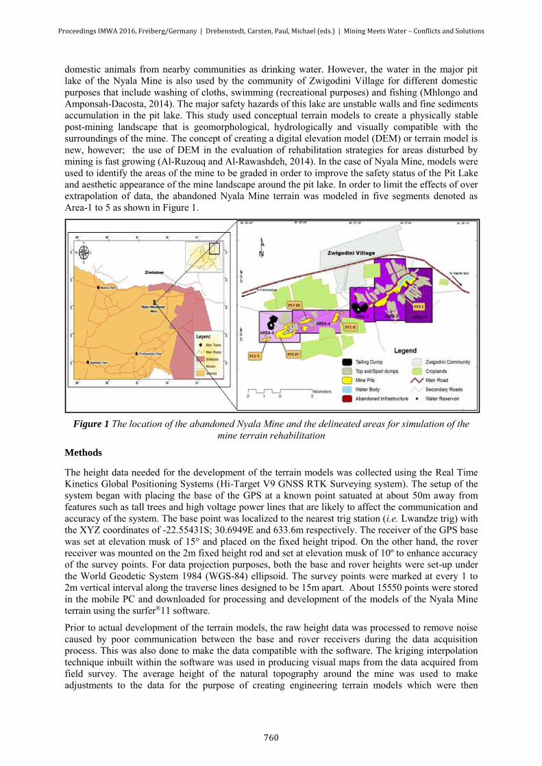
domestic animals from nearby communities as drinking water. However, the water in the major pit lake of the Nyala Mine is also used by the community of Zwigodini Village for different domestic purposes that include washing of cloths, swimming (recreational purposes) and fishing (Mhlongo and Amponsah-Dacosta, 2014). The major safety hazards of this lake are unstable walls and fine sediments accumulation in the pit lake. This study used conceptual terrain models to create a physically stable post-mining landscape that is geomorphological, hydrologically and visually compatible with the surroundings of the mine. The concept of creating a digital elevation model (DEM) or terrain model is new, however; the use of DEM in the evaluation of rehabilitation strategies for areas disturbed by mining is fast growing (Al-Ruzouq and Al-Rawashdeh, 2014). In the case of Nyala Mine, models were used to identify the areas of the mine to be graded in order to improve the safety status of the Pit Lake and aesthetic appearance of the mine landscape around the pit lake. In order to limit the effects of over extrapolation of data, the abandoned Nyala Mine terrain was modeled in five segments denoted as Area-1 to 5 as shown in Figure 1.
Figure 1 The location of the abandoned Nyala Mine and the delineated areas for simulation of the
mine terrain rehabilitation
Methods
The height data needed for the development of the terrain models was collected using the Real Time Kinetics Global Positioning Systems (Hi-Target V9 GNSS RTK Surveying system). The setup of the system began with placing the base of the GPS at a known point satuated at about 50m away from features such as tall trees and high voltage power lines that are likely to affect the communication and accuracy of the system. The base point was localized to the nearest trig station (i.e. Lwandze trig) with the XYZ coordinates of -22.55431S; 30.6949E and 633.6m respectively. The receiver of the GPS base was set at elevation musk of 15° and placed on the fixed height tripod. On the other hand, the rover receiver was mounted on the 2m fixed height rod and set at elevation musk of 10º to enhance accuracy of the survey points. For data projection purposes, both the base and rover heights were set-up under the World Geodetic System 1984 (WGS-84) ellipsoid. The survey points were marked at every 1 to 2m vertical interval along the traverse lines designed to be 15m apart. About 15550 points were stored in the mobile PC and downloaded for processing and development of the models of the Nyala Mine terrain using the surfer®11 software.
Prior to actual development of the terrain models, the raw height data was processed to remove noise caused by poor communication between the base and rover receivers during the data acquisition process. This was also done to make the data compatible with the software. The kriging interpolation technique inbuilt within the software was used in producing visual maps from the data acquired from field survey. The average height of the natural topography around the mine was used to make adjustments to the data for the purpose of creating engineering terrain models which were then
Proceedings IMWA 2016, Freiberg/Germany | Drebenstedt, Carsten, Paul, Michael (eds.) | Mining Meets Water – Conflicts and Solutions
760

superimposed on the terrain models shown on the present topography of the mine. This allowed that the cut-and-fill areas and volumes are accurately determined. The volumes were computed as average of volumes calculated using the extended trapezoidal, extended Simpson’s, and Simpson’s 3/8 rules expressed mathematically as shown in equation (i), (ii) and (iii) and inbuilt in the software. In these equations, ∆x represents the grid column spacing, ∆y represents the grid row spacing, and Gi,j
represents the grid node value in row i and column j. The accuracy of the determined volume was judged by the difference in the volume computed using the three methods. Where the three estimated volumes were reasonable close to each other, the overall volume estimate was considered accurate. In cases where a huge discrepancy between the estimated volumes was identified, the computed volume was considered not reliable thus the computation was repeated.
Extended trapezoidal:
(i)
Where: the pattern of coefficients is: 1, 2, 2, 2,…, 2, 2, 1
Extended Simpson’s:
(ii)
Where: the pattern of coefficients is: 1, 4, 2, 4, 2, 4, 2,…, 4, 2, 1
Simpson’s 3/8 rule:
(iii)
Where: the pattern of coefficients is 1, 3, 3, 2, 3, 3, 2,…, 3, 3, 2, 1
The terrain slope map of the pit lake and the surroundings was developed and used to analyze the average steepness of the slopes of the lake. In this case, the pit lake slope map was developed to provide the necessary understanding of the general steepness of the pit lake slopes. In addition, the pit-lake catchment area and vector map were developed and used to identify the areas contributing to the accumulation of runoff and sediments deposition in the pit lake. This was used as a way of locating areas that contribute significantly in the deposition of safety hazardous fine sediments in the pit lake bottom.
Results
The modeled terrain of the mine covered the whole 212ha area of the mine and depicted the two large tailings dumps, five well defined surface excavations and several heaps of spoil dumps. Area 1 and 2 covered the area that is mainly occupied by the only pit lake at the mine site. Several piles of spoil material dumped around the pit lake have changed the previously flat and enviable terrain to a rugged landscape (see Fig2a and b). The area covered by the lake was estimated to be 11ha and its deepest part was estimated to be approximately 22m. According to the pit lake slope model shown in Fig2c, most of the pit lake slopes are generally physically stable with the majority of slope angle ranging from 15° to 20°. However, it is necessary that these slopes be graded to relatively flat angles in order to reduce the amount of fine materials that are deposited at the bottom of the pit lake due to various processes including erosion. The vector map shown in Fig2d illustrates that the pit lake accumulate
Ai =∆x
2[Gi,1 + 2Gi,2 + 2Gi,3 … + 2Gi,nCol−1 + Gi,nCol]
Volume ≈ ∆y
2[A1 + 2A2 + 2A3 + ⋯ + 2AnCol−1 + AnCol]
Ai =3∆x
3[Gi,1 + 4Gi,2 + 2Gi,3 + 4G1,4 + ⋯ + 2Gi,nCol−1 + Gi,nCol]
Volume ≈ ∆y
3[A1 + 4A2 + 2A3 + 4A3 … + 2AnCol−1 + AnCol]
Ai =3∆x
8[Gi,1 + 3Gi,2 + 3Gi,3 + 2G1,4 + ⋯ + 2Gi,nCol−1 + Gi,nCol]
Volume ≈ 3∆y
8[A1 + 3A2 + 3A3 + 3A3 + ⋯ + 2AnCol−1 + AnCol]
Proceedings IMWA 2016, Freiberg/Germany | Drebenstedt, Carsten, Paul, Michael (eds.) | Mining Meets Water – Conflicts and Solutions
761

much of surface run-off from the areas that are highly disturbed by mining and occupied by highly erodible magnesite tailing material. According to Sibanda et al. (2013), the mine tailings at Nyala Mine comprise of 43% gravel, 53% fine sand and 5% fines (i.e. silt and clay). In generally, soils that are dominated by fine sands and silt and lack organic matter are the most erodible soils (O’Geen et al., 2006). The erosive property of fine materials coupled with the high slope angles directly influence surface runoff from the slopes of the tailings dump to the lowest part of the pit lake. This therefore explains the presence of fine sediments that deposited at the floor of the lake. It needs to be noted also that other factors such as slope length and unprotected nature of the slopes of the tailings dumps have influence on the soil erosion problem.
According to Qing-quan et al. (2001), the amount of surface runoff decreases with the decreasing slope angle while the flow velocity increase and decrease before and after the maximum slope of 40.9° respectively. The fact that the walls of the pit lake are made up of rippable metamorphosed shales and sandstones, based on the Maryland Standards and Specifications for soil Erosion and Sediment Control (2011), the grading of these slopes to angle of 14° (i.e. 4:1) was found appropriate. This slope angle will assist in curbing excessive erosion of the pit lake walls and subsequently control the amount of sediments deposited in the lake. It is expected that this slope design stretch the slope length to about 20m (maximum length) thus it necessary that a 1m reverse bench be introduced to divide the slope length into two equal halves. This slope design is expected to further reduce the runoff velocity or speed and indirectly reduce the rate of erosion of the slopes of the pit lake. This slope design approach is supported by Gilley et al.(1978) and Qing-quan et al. (2001) that in general, the runoff rate and velocity, sediments concentration, and rate of soil loss increase with an increasing slope length. This concept of introducing reverse bench in the design will channel runoff water to more stable (i.e. gabion protected) inflow channels to be placed along the shallow parts of the pit lake. In view of this, the reverse bench is to be constructed with a maximum slope angle of 1.7° to allow easy flow of runoff water to the protected inflow channel.
In order to further limit or eliminate the continuous supply of fine sediments to the pit lake, it is suggested that a flat topography be created around the lake. This will involve grading of about 737068m³ material over an area of about 23ha to fill a 610264m³ void that covers approximately 5ha area. The areas of cut and fill in the reshaping of the terrain around the pit lake are shown in Fig3.
Figure 3 (A) and (B) are the models showing the current terrain in Area-1 and 2, (C) is the pit lake slope analysis model, and (D) is an illustration of surface run-off accumulation flow to the pit lake.
Proceedings IMWA 2016, Freiberg/Germany | Drebenstedt, Carsten, Paul, Michael (eds.) | Mining Meets Water – Conflicts and Solutions
762
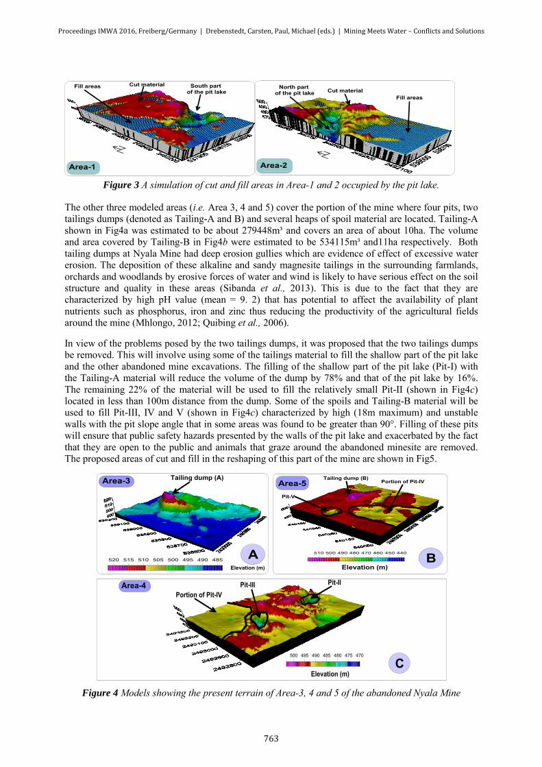
Figure 3 A simulation of cut and fill areas in Area-1 and 2 occupied by the pit lake.
The other three modeled areas (i.e. Area 3, 4 and 5) cover the portion of the mine where four pits, two tailings dumps (denoted as Tailing-A and B) and several heaps of spoil material are located. Tailing-A shown in Fig4a was estimated to be about 279448m³ and covers an area of about 10ha. The volume and area covered by Tailing-B in Fig4b were estimated to be 534115m³ and11ha respectively. Both tailing dumps at Nyala Mine had deep erosion gullies which are evidence of effect of excessive water erosion. The deposition of these alkaline and sandy magnesite tailings in the surrounding farmlands, orchards and woodlands by erosive forces of water and wind is likely to have serious effect on the soil structure and quality in these areas (Sibanda et al., 2013). This is due to the fact that they are characterized by high pH value (mean = 9. 2) that has potential to affect the availability of plant nutrients such as phosphorus, iron and zinc thus reducing the productivity of the agricultural fields around the mine (Mhlongo, 2012; Quibing et al., 2006).
In view of the problems posed by the two tailings dumps, it was proposed that the two tailings dumps be removed. This will involve using some of the tailings material to fill the shallow part of the pit lake and the other abandoned mine excavations. The filling of the shallow part of the pit lake (Pit-I) with the Tailing-A material will reduce the volume of the dump by 78% and that of the pit lake by 16%. The remaining 22% of the material will be used to fill the relatively small Pit-II (shown in Fig4c) located in less than 100m distance from the dump. Some of the spoils and Tailing-B material will be used to fill Pit-III, IV and V (shown in Fig4c) characterized by high (18m maximum) and unstable walls with the pit slope angle that in some areas was found to be greater than 90°. Filling of these pits will ensure that public safety hazards presented by the walls of the pit lake and exacerbated by the fact that they are open to the public and animals that graze around the abandoned minesite are removed. The proposed areas of cut and fill in the reshaping of this part of the mine are shown in Fig5.
Figure 4 Models showing the present terrain of Area-3, 4 and 5 of the abandoned Nyala Mine
Proceedings IMWA 2016, Freiberg/Germany | Drebenstedt, Carsten, Paul, Michael (eds.) | Mining Meets Water – Conflicts and Solutions
763

Figure 5 A simulation of cut and fill areas in Area-4 and 5 of the mine
Conclusions
The mapping of the slopes of the pit lake showed that the majority of the slopes were generally stable with the maximum angle of 48°. However, in order to minimize the effect of erosion on the slopes of the pit lake and reduce deposition of fine sediments in the pit lake floor where they present safety hazards to the animals who drink the water in the lake, it was deemed expedient that the slopes of the pit lake are reduced to 14° and be designed with a reverse bench. Such a design of the pit lake walls will play a crucial role in reducing the velocity of water runoff and ensure that the runoff inflow into the lake is controlled.
Based on calculations regarding cut and fill volumes and areas from the developed surface models for the mine, it was established that the reshaping of the Nyala Mine terrain will require a total of 2269377m³ materials to be graded to fill a void of about 2095037m³. It was also established that the grading of the Nyala Mine terrain with the purpose of creating a flat topography that blends well with the surroundings will leave a footprint of about 72ha which will require ripping of the soil to allow easy growth of vegetation.
In general, the surface models for the rehabilitation of the Nyala Mine terrain provided the technical base for the analysis of the mine terrain and determination of excavation and filling of areas and volumes. This provided the most needed information for estimation of the amount of earthwork required in the improvement of the aesthetic beauty of the landscape of the abandoned Nyala Mine and safety of its featured pit lake.
Acknowledgements
The authors would like to acknowledge the University of Venda and the mining qualifications authorities (MQA) for funding the work presented in this paper. The assistance given by Mr. Zenzele Sibanda, Ms. Phumudzo Mudau and Mr. Michael Mbati (all the members of the Abandoned Mines, Mine Closure and Rehabilitation Research Group, University of Venda) in the field survey stage of this work is greatly acknowledged.
References
Al-Ruzouq R and Al-Rawashdeh S (2014) Geomatics for Rehabilitation of Mining Area in Mahis, Jordan, Journal of Geographic Information System, Vol. 6, pp. 123-134.
Deupe RG, Lymbery AL (2005) Environmental risks associated with beneficial end uses of mine pit lakes in South Western Australia. IMWA Springer-Verlag, 24, p134-188
Lund MA and Blanchette ML (2014) Are We Approaching Pit Lake Closure from the Wrong Perspective? In: Sui, Sun and Wang (eds), An Interdisciplinary Response to Mine Water Challenges. China University of Mining and Technology Press, Xuzhou, pp. 210-224
Lin C, Tong X, Lu W, Yan L, Wu Y, Nie C, Chu C and Long J (2005) Environmental Impacts of Surface Mining on Mined Lands, Affected Streams and Agricultural Lands in the Dabaoshan Mine Region, Southern China, Land degradation and development, 16, pp. 463–474.
Proceedings IMWA 2016, Freiberg/Germany | Drebenstedt, Carsten, Paul, Michael (eds.) | Mining Meets Water – Conflicts and Solutions
764

Mhlongo SE (2012) Development of a Modeling Framework for Design of Low-Cost and Appropriate Rehabilitation Strategies for Nyala Abandoned Mine. Unpublished MSc. Dissertation, Department of Mining and Environmental Geology, University of Venda, p. 175.
Mhlongo SE and Amponsah-Dacosta F (2014) Assessment of Safety Status of Open Excavations and Water Quality of Pit Lake at Abandoned Nyala Mine in Limpopo Province of South Africa. In: Sui, Sun and Wang. An Interdisciplinary Response to Mine Water Challenges, China University of Mining and Technology Press, Xuzhou, pp. 395-399.
Strydom JH (1998) Magnesite, In: The Mineral Resources of South Africa (Wilson MGC and Anhaeusser CR, eds): Handbook. Council of Geosciance, 16, pp. 444-449.
The Mineral Potential and Mining Development in the Black Homelands of South Africa (1977), Chris van Ransburg Publications (Pty) Ltd, Johannesburg, p. 83.
Qiubing W, Jingkuan W, Xinyu Z, Jun L, Xinzhi C, and Yulong Z (2006), Effect of Dust from Magnesite Calcination on Soil Physical and Chemical Properties. 18th World Congress of Soil Science, July 9-15, 2006 - Philadelphia, Pennsylvania, USA
Qing-quan L, Li C and Jia-chun L (2001) Influences of slope gradient on soil erosion, Applied Mathematics and Mechanics, English Edition, Vol.2 (5), pp. 510-519
O’Geen A.T, Elkins R and Lewis D (2006) Erodibility of Agricultural Soils, with examples in Lake and Mendocino Countres, University of Califonia, Division of Agriculture and Natural Resources, p.6
Proceedings IMWA 2016, Freiberg/Germany | Drebenstedt, Carsten, Paul, Michael (eds.) | Mining Meets Water – Conflicts and Solutions
765