Embed Size (px)
Citation preview

A comprehensive solution for publishing
geospatial information via the Web
Bentley Geo Web Publisher

Presentation Overview
• What is Geo Web Publisher?
• Map Server, Web GIS
• Where is Geo Web Publisher used?
• Top Features
• What’s New in Geo Web Publisher Select Update?
• More Information?

What is Geo Web Publisher?
• Comprehensive Web GIS solution for publishing geospatial information via the Web
− Easy to implement, high performance − Brings together multiple data sources, and databases − Fully integrated with the geospatial desktop tools− OGC compliant, WMS server
• Advanced tools for GIS Web site administration and authoring.• End user tools for map navigation, query, analysis, reporting
and more.

A picture is worth 1000 wordsAdministration tools GIS Web Site
Operational Web GIS sites can be fully created and managed from the Administration tools. No programming required.

Geo Web Publisher Value Proposition• Integrate a variety of graphical sources
• Integrate a variety of non-graphical data sources
• Author and administer general or specialized GIS web sites:
− Via easy-to-use tools that do not require web development skills
− Through web development techniques
• Intelligent publishing:− Vector and raster − A choice of clients appropriate for
internal users, third parties, or the public

Map Server, Web GIS
• A Map Server will publish a map and its Table of Content.
• A Web GIS will allow users to find assets, get reports, and interact with a map if need be.
• A Web GIS usually needs a Map Server for displaying maps, it is a important piece but not all that is needed.

Map
Table Of Content
Table Of Content
Map (with tools)
Searches
Reports
Map Server
Web GIS

Navigating databases, Key aspect of GIS
• Geo Web Publisher can integrate database information along with graphical data (map layers).
• GWP Administrators can set up advanced searches, advanced reports and pre-set thematic mapping.
• Database tables not directly linked to spatial objects can be tied to map layers, queried and used just like any other table.

Geo Web Publisher User Examples

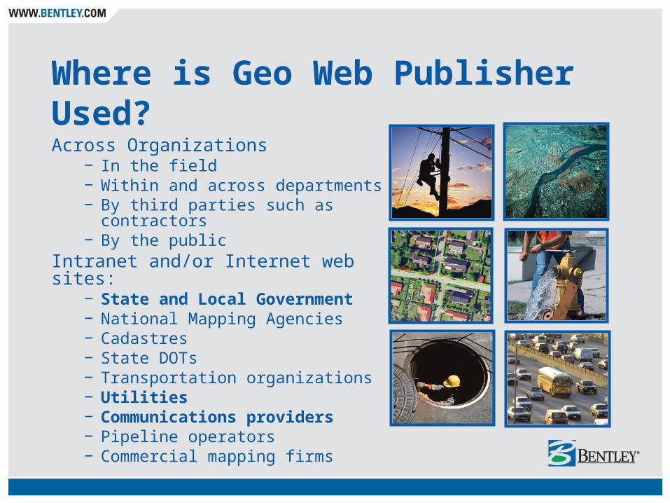
Where is Geo Web Publisher Used?Across Organizations
− In the field− Within and across departments− By third parties such as contractors− By the public
Intranet and/or Internet web sites: − State and Local Government− National Mapping Agencies− Cadastres− State DOTs − Transportation organizations− Utilities− Communications providers− Pipeline operators− Commercial mapping firms

eCity users can search and display property related mapping and aerial imagery on the eCity portal 24X7.
City of Mississauga
Project:• eMaps is part of the eCity portal• Mississauga is Canada’s sixth largest city.
Objectives:• eCity’s objective is to realize savings through a
cost avoidance model and provide an increase in customer service to the residents and clients.
• eMaps implements a robust multi-functional interactive online mapping site that is closely tied with the corporate systems and processes.
Fast facts:• eMaps will reduce the number of information
inquiry calls to the City. Mississauga estimates the number of calls will significantly decrease and anticipates associated savings of $10,000’s/year from this alone.

Oldham Metropolitan BC
Project:• Intranet - Internet Implementation• Oldham Metropolitan Burrough Council
Objectives:• to provide on demand, simple and easy
access to corporate data • to enable in-house users make informed
decisions • to provide members of the public with
direct access to the same information.
Fast facts:• Provides access to the authority’s land and
property assets, detailed highway records, school locations and contact details, community and public building locations and details. Also, a wide variety of other generic maps are provided.

E-Map can provide shortest route/driving directions, produce
thematic maps, perform vicinity searches, pin-point landmarks
and generate custom reports through English and Arabic
language interfaces .
Saudi Telecom
Project:• E-Map GIS Intranet Project• Saudi Telecom Company
Objectives:• Integrate many geospatial data sources into an
Oracle Spatial datastore and make them accessible to users via the Web.
Fast facts:• Saudi Telecom Co. (STC) is the
telecommunication services provider in Saudi Arabia
• Includes network data, telecom facilities, landbase, points of interest, navigable street data, and satellite imagery.

Data is immediately available with precision and richness not available with
the former system. Customers can easily be identified to improve customer
service, such as fast and efficient communication regarding outages.
SNAM Rete Gas
Project:• GIS Intranet
Objectives:• Allow access via the SRG nationwide intranet to
geospatial data about the gas transmission network • Support an environment which supports technical
inquiries from web clients
Fast facts:• SNAM’s transmission network is stored in Oracle
Spatial. The GIS Intranet provides access to the gas network typology and functional status. Multiple scales of raster landbase are supported
• Different criteria can be selected for generating reports and map visualization.
• Network elements can be queried and screen views can be exported in PDF, JPEG and/or printed.

Real-time access to accurate geospatial data has promoted better
governmental decision making and a more informed public.
Urzad Marszalkowski Woj. DolnoSlask.
Project:• DSIP - Province Integrated Information System • Lower Silesia, Wroclaw, Poland
Objectives:• Aid local government in making better, well
informed decisions with more current, accurate information
• Improve efficiency and data sharing via intranet and internet sites
Fast facts:• Lower Silesia’s Geographic Information System
is an Oracle Spatial based repository of geospatial data for the province
• In addition to data sharing among government entities, DSIP offers online Internet information services for the public.

The application saves significant time and effort in producing high-quality
web-based maps. “Enriching the e-government Internet site with spatial
information is five minutes work, instead of (taking) three weeks (of)
programming.”
City of Eindhoven
Project:• E-government Site• Gemeente Eindhoven
Objectives:• A solution to incorporate spatial information from
Oracle Spatial in the e-government Internet site of the municipality to aid in supporting information and operation products for the citizens
Fast facts:• The site provides creative incorporation of spatial
information in the government website• It offers the ability to perform spatial data edits via
the website• Project Web Site:
http://www.bestemmingsplannen.eindhoven.nl
Top Features of Geo Web Publisher

Top 10 Features
1. Integrate many information sources2. Advanced database integration 3. Authoring GIS web sites4. Advanced query and reporting5. Spatial Analysis, Thematic Mapping6. Customization possibilities7. Flexible deployment
8. Superior quality publishing 9. High performance publishing10. Support of OGC standards

Integrate Many Information Sources
Integrate for display, analysis, and reporting:
− DGN (including XFM of course)− DWG− SHP− Oracle Spatial − MicroStation GeoGraphics − Bentley Map − Multiple relational databases
» ODBC» Non-graphical» Graphical from stored coordinates
− 30+ industry-standard raster formats
− Raster mosaics− Multimedia− Hyperlinks

Top 10 Features
1. Integrate many information sources2. Advanced database integration 3. Authoring GIS web sites4. Advanced query and reporting5. Spatial Analysis, Thematic Mapping6. Customization possibilities7. Flexible deployment
8. Superior quality publishing 9. High performance publishing10. Support of OGC standards

Database Integration
• Creating searches, reports and thematic mapping from databases linked to layers:
Searches
Reports
Thematic
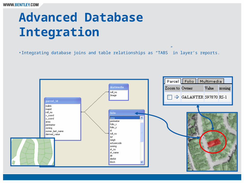
Advanced Database Integration
• Integrating database joins and table relationships as “TABS” in layer’s reports.

Top 10 Features
1. Integrate many information sources2. Advanced database integration 3. Authoring GIS Web sites4. Advanced query and reporting5. Spatial Analysis, Thematic Mapping6. Customization possibilities7. Flexible deployment
8. Superior quality publishing 9. High performance publishing10. Support of OGC standards

Administration Tool
Local application but remote administration
Windows authentication by silent sign on or local user (for sites located on a DMZ)
Easy to use user interface for:− defining data source
connections− database logins− web server options− cache configuration− other parameters

Site Creation and Management Tool
Extremely fast website creation
Designed to support progressive or phased implementation
GIS user-friendly
Simple-to-Use Client Tools
Web-compliant source code that can be merged with any web site

Web Site Authoring: Introduction
Website aesthetics – how does it look?− Colors− Decorative Images− Icons
Website layout – what and where do objects go?
− Map Viewer − Overview Map− Queries− Report − Layers− Thematic Legend− Others
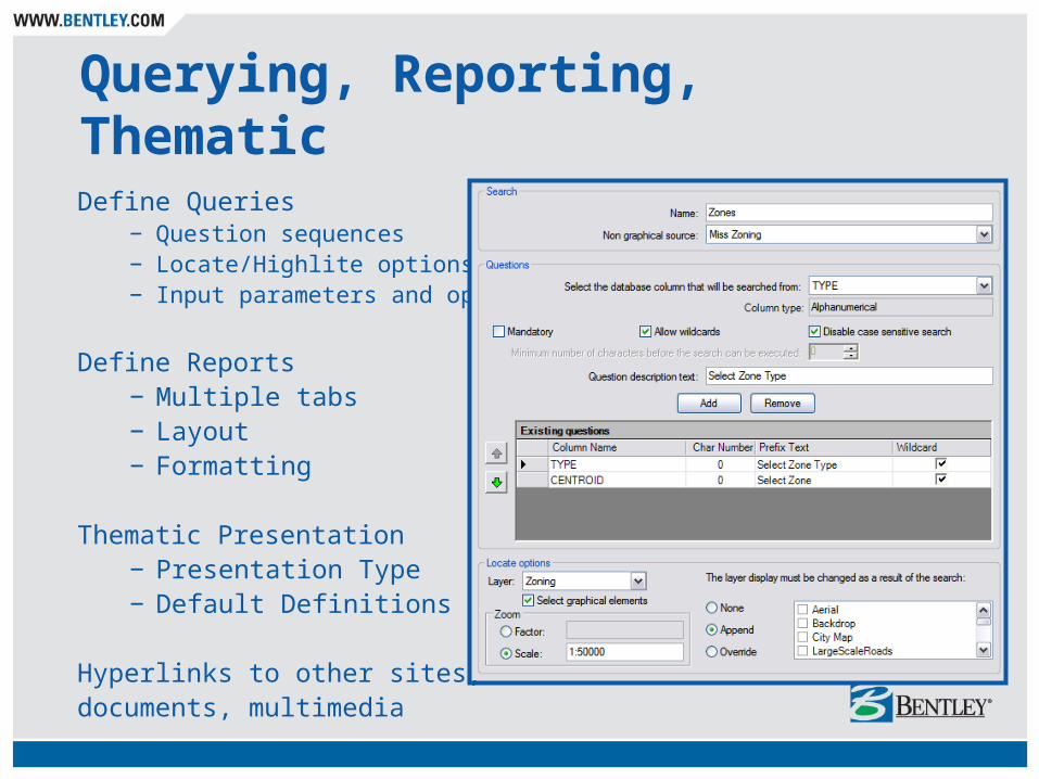
Querying, Reporting, Thematic
Define Queries− Question sequences− Locate/Highlite options− Input parameters and options
Define Reports− Multiple tabs− Layout− Formatting
Thematic Presentation− Presentation Type− Default Definitions
Hyperlinks to other sites,documents, multimedia

Top 10 Features
1. Integrate many information sources2. Advanced database integration 3. Authoring GIS web sites4. Advanced query and reporting5. Spatial Analysis, Thematic Mapping6. Customization possibilities7. Flexible deployment
8. Superior quality publishing 9. High performance publishing10. Support of OGC standards

Querying
Query non-graphical sources related to graphical sources:
− Tables− Views− Joins− Queries
Easy Query Builder− Simple Query− Complex, Chained Questions− Multiple databases− Query parameters
» Question Description» Wild Card» Minimum Characters
− Locate » Select Element
− Zoom Scale− Display Layers
Customized queries can also be implemented

Reporting
Reporting− Layout− Sorting− Aliases− Multi-selection− Prefix/Suffix− HTML− Downloadable CSV− Tabs, Columns, Rows− Multiple questions searches
» Fit to scale» Select» Display options
− Multimedia linksOutput
− Screen− CSV File− Print/Plot− Copy/Paste
Can also be customized

Top 10 Features
1. Integrate many information sources2. Advanced database integration 3. Authoring GIS web sites4. Advanced query and reporting5. Spatial Analysis, Thematic Mapping6. Customization possibilities7. Flexible deployment
8. Superior quality publishing 9. High performance publishing10. Support of OGC standards

Spatial Analysis
Buffer Zone or Polygon Overlay− Review selected features− Generate Reports
Used in a variety of applications:− General proximity analysis− Customer notification reports− Call before you dig − Market studies− And many more!

Thematic MappingThematically resymbolize based on database properties
− unique values− equal ranges− equal count
Thematic object depicts a handy legend for interpretation
Symbolization sets − can be pre-configured for novice
users − site users can be allowed to
interactively define presentation parameters
Use in workflows with reporting and overlay queries for end-to-end analysis workflows

Creating Thematic MappingDefine
− Name− Layers− Database sources
Legend Properties− Location on layout− Font, Color, Size− Default color ramp
Unique Value− Included/Excluded Values− Aggregate values into groups − Default color palette/ramp
Equal Ranges− Interval Definitions
Equal Count

Top 10 Features
1. Integrate many information sources2. Advanced database integration 3. Authoring GIS web sites4. Advanced query and reporting5. Spatial Analysis, Thematic Mapping6. Customization possibilities7. Flexible deployment
8. Superior quality publishing 9. High performance publishing10. Support of OGC standards

Customization of Geo Web Publisher GIS Sites
1. Site creation and administration with the off the shelf tools
2. Changing the site skin using a CSS file (Custom Style Sheet)
3. Programmable searches embedded within basic web sites
4. Creating custom widgets and inserting them in the Site Authoring tool
5. Changing the Site Authoring tool by altering its source code

Top 10 Features
1. Integrate many information sources2. Advanced database integration 3. Authoring GIS web sites4. Advanced query and reporting5. Spatial Analysis, Thematic Mapping6. Customization possibilities7. Flexible deployment 8. Superior quality publishing 9. High performance publishing10. Support of OGC standards


Flexible Deployment Approach• End User
− WMS Client− Map Viewer
» Downloadable» Install for easier intranet deployment
• Administration and Authoring− Client Web tools
» Administration» Map Author» Site Author
− Authentication» Power Users» Administrators» Local users (DMZ)
− Installs unlimited− Can be used remotely

iDPR Desktop Integration with the Geospatial Server
Pre-publishing of updates from ProjectWise is managed behind the scene
Leverages versioning and workflow knowledge in the Geospatial Server to determine and initiate needed updates
Can be run from the Windows Scheduler
Ensures Web users are always in sync withinformation managed by the Geospatial Server

Automated iDPR Generation
“Cache” can be generated automatically when source files are changed.

Top 10 Features
1. Integrate many information sources2. Advanced database integration 3. Authoring GIS web sites4. Advanced query and reporting5. Spatial Analysis, Thematic Mapping6. Customization possibilities7. Flexible deployment
8. Superior quality publishing 9. High performance publishing10. Support of OGC standards

Superior Quality, Rich Publishing
• High Fidelity DGN/DWG Publishing (mapping)
• Original presentation quality
• Map Authoring
• Pre-published and dynamic layers
• Resymbolize during pre-publishing or create dynamic new representations

“Hybrid” Maps
• Maps can be composed of “GIS” layers composed of unique geometry types in order to support analysis and thematic symbolization tools ….
• …. as well as “Mapping” layers composed of multiple geometry types and multiple symbolization types
+ =

Top 10 Features
1. Integrate many information sources2. Advanced database integration 3. Authoring GIS web sites4. Advanced query and reporting5. Spatial Analysis, Thematic Mapping6. Customization possibilities7. Flexible deployment
8. Superior quality publishing 9. High performance publishing10. Support of OGC standards

High Performance Publishing
Web–optimized vector publishing− Pre-publishing to a web-optimized format (iDPR)− Tiling− Overview− Streaming
iDPR Desktop− Manages pre-publishing updates behind the scenes− Integrates with the Geospatial Server
Raster via Image Server− Tiling− Overview− Streaming

Top 10 Features
1. Integrate many information sources2. Advanced database integration 3. Authoring GIS web sites4. Advanced query and reporting5. Spatial Analysis, Thematic Mapping6. Customization possibilities7. Flexible deployment
8. Superior quality publishing 9. High performance publishing10. Support of OGC standards

Support of OGC Standards
• OGC’s Web Map Service
• WMS 1.1.1 client ( Map layers can result form a WMS query)
• WMS 1.1.1 Server ( Map outputs in WMS)
− Support for output of raster images in jpeg and png
− Any WMS client can view Geo Web Publisher maps
• Provides for 2 ways interoperability with other vendor solutions supporting WMS server and or client
• WFS server implementation in progress

Benefits of Bentley GWP1. Capitalizes on your investment in information. Integrates a wide
variety of information sources including corporate databases and enterprise systems.
2. Improves productivity across your organization by avoiding duplicate or counterproductive work scenarios due to poor information exchange.
3. Enables and easily blends with real life processes at all levels; field, departmental, enterprise, cross-organizational, and public.
4. Serves a wide range of user types - gets the right information to the right people at the right time.
5. Distributes access outside your organization to third parties or the general public in order to improve communications, increase awareness, and provide for self-service scenarios that save you time and manpower.
Benefits of Geo Web Publisher6. Designed for quick initial implementations to speeds return
on investment and to allow more complex phased implementations to occur over time.
7. Ideal for small organizations getting started with web implementations and scalable to support the requirements of very large organizations.
8. Improve information quality by sharing it with multiple stakeholders who provide feedback.
9. Implement project, departmental, corporate sites, or public websites with an overall low cost of ownership.
10. Improve inter-departmental cooperation and communication among users in geographically dispersed locations, including remote workers and field users.

Bentley Geo Web PublisherImplementation

Bentley Professional Services
Experts in the Geospatial Information Technology and System Integration that help organizations make the best use of people and Web technology
• Local SolutionsWare Approach - speeds specific types of implementation.• Business Process Consulting – matching business goals to workflows
and systems when implementing integration with enterprise systems• Solution Implementation – customizing and implementing solutions that
are on-time and effective• System Integration – connecting enterprise information and systems

A comprehensive solution for publishing
geospatial information via the Web
Bentley Geo Web Publisher
![Stefanakis, E., 2015. Web Mapping and Geospatial Web Services … · 2015. 9. 16. · Web Mapping and Geospatial Web Services. CreateSpace Independent Publ. [In English], pp.168](https://img.pdfslide.us/doc/110x75/5fde9b9018e8ab5f1726cfeb/stefanakis-e-2015-web-mapping-and-geospatial-web-services-2015-9-16-web.jpg)