Embed Size (px)
Citation preview

A COMPARATIVE STUDY OF LAND USE AND LAND COVER ANALYSIS OF KARACHI USING MODIS AND
LANDSAT DATASETS
A COMPARATIVE STUDY OF LAND USE AND LAND COVER ANALYSIS OF KARACHI USING MODIS AND
LANDSAT DATASETS
JIBRAN KHAN, DAWOOD CO-AUTHORS: MARYAM ALTAF & INTIKHAB ULFAT
JIBRAN KHAN, DAWOOD CO-AUTHORS: MARYAM ALTAF & INTIKHAB ULFAT

• Introduction and Objectives
• Site and Data Acquisition
• Image Processing and Methodology
• Results and Discussion
• Limitations and Future Work
• Conclusion
PROCEDURE

INTRODUCTION AND OBJECTIVES
• Land cover composition has a direct influence on urban ecological system
• Karachi has been through intense urbanization during last two decades and many studies have already been performed using Landsat data
• Applicability of MODIS data has been tested for the LULC analysis through this comparative study
OUR AIM IS: “TO DEVELOP A NEW TECHNIQUE TO STUDY LAND USE AND LAND
COVER (LULC) CHANGE OF KARACHI – A FIRST OF ITS KIND COMPARATIVE APPROACH USING MODIS AND LANDSAT DATA”

INTRODUCTION AND OBJECTIVES
• Considering the variety and complexity of urban ecological studies, our approach is restrictive only to NDVI, Slope and Aspect
• Factors such as: - Soil and moisture content - Anthropogenic factors are not considered as significant during this study

SITE AND DATA ACQUISITION
• The subject of our study is the city of Karachi
• Multi-temporal single date daily surface reflectance data at 500m resolution acquired from USGS has been used in this study (year 2011)
• Landsat 7 Imagery of Karachi has also been used (year 2011)
• Town boundaries maps, DEM of Karachi is also used
Study Area showing map of Karachi (Source: S.J.H. Kazmi, Geography
Department, UoK)

IMAGE PROCESSING & METHODOLOGY
• Decision tree classification of Karachi (using MODIS Surface reflectance, DEM derived slope & aspect of Karachi and band 2 of MODIS)
• Unsupervised classification of both MODIS and Landsat Imageries (5 number of classes)
• Comparison of both classified MODIS and Landsat data
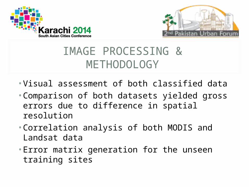
IMAGE PROCESSING & METHODOLOGY
• Visual assessment of both classified data
• Comparison of both datasets yielded gross errors due to difference in spatial resolution
• Correlation analysis of both MODIS and Landsat data
• Error matrix generation for the unseen training sites

RESULTS: DECISION TREE CLASSIFICATION
Decision Tree of Karachi
Water
VegetationHigh ImperviousLow Impervious
Open area

RESULTS: UNSUPERVISED K-MEANS CLASSIFICATION
Unsupervised Classification of Landsat 7 (left) and MODIS data (right) of Karachi

RESULTS: COMPARATIVE ANALYSIS
Image showing the comparison of graphs of pixels data of classified Landsat (left) and MODIS (right) data (Source: ArcGIS v10.2)

RESULTS: CORRELATION ANALYSIS
Image showing the correlation of pixels data using R software
Image showing the statistical analysis of both MODIS and Landsat data (Correlation coefficient of 0.96 is found)

RESULTS: ERROR MATRIX
Overall Accuracy 0.596491228 (Approx. 60%)Kappa Coefficient = 0.4773
Ground Truth (Pixels)Class Water Vegetation High Impervios Low Impervious Open Area
Unclassified 0 0 0 0 0Class 1 64 126 0 0 0Class 2 0 131 19 0 0Class 3 0 0 212 30 0Class 4 0 0 152 292 22Class 5 0 0 4 222 151Total 64 257 387 544 173
Ground Truth (Percent)Class Water Vegetation High Impervios Low Impervious Open Area
Unclassified 0 0 0 0 0
Class 1 100 49.03 0 0 0
Class 2 0 50.97 4.91 0 0
Class 3 0 0 54.78 5.51 0
Class 4 0 0 39.28 53.68 12.72
Class 5 0 0 1.03 40.81 87.28
Total 100 100 100 100 100

RESULTS: ERROR MATRIX
Class Producer Accuracy User Accuracy Producer Accuracy User Accuracy
(Percent) (Percent) (Pixels) (Pixels)
Class 1 100 33.68 64/64 64/190
Class 2 50.97 87.33 131/257 131/150
Class 3 54.78 87.6 212/387 212/242
Class 4 53.68 62.66 292/544 292/466
Class 5 87.28 40.05 151/173 151/377

CONCLUSION AND DISCUSSION
• A new map of land cover of Karachi has been developed which is generally consistent with Landsat-derived land cover map
• Comparison of MODIS and Landsat data showed a high level of correspondence
• Correlation coefficient of 0.96 is found showing a strong degree of association between both datasets
• For unseen training sites an error matrix has been generated with overall accuracy of 60%
• However with some limitations, the results demonstrated the applicability of MODIS data and decision tree classifier approach

LIMITATIONS AND FUTURE PROSPECTS
• The unavailability of Nadir Bidirectional Reflectance Distribution Function (BRDF) Adjusted (NBAR) data at 500m resolution presented a limitation here
• The availability of BRDF corrected and improved 500 m MODIS data could help rectify classification inaccuracy
• The careful selection of cloud free surface reflectance data is also important
• Performing field observations could result in reducing classification errors

Questions/Suggestions?

THANK YOU!