Embed Size (px)
Citation preview
WATERFORD GREENOPEN HOUSE #3 – April 4th, 2012
A COMMUNITY PLAN FOR A COMMUNITY PLAN FOR A COMMUNITY PLAN FOR A COMMUNITY PLAN FOR
welcomepresentation outline
1. Planning Directions
2. Summary of Previous Presentations
3. Neighbourhood Vision and Design
4. Development Schedule & Phasing Plan

planning directions
Our Winnipeg, Winnipeg’s new Development Plan,
identifies Meadows West North as a New Community.
Winnipeg’s New Communities are expected to play a
key role in accommodating the City’s projected
180,000 increase in population over the next 20 years.
New Communities are to be designed to provide
City of Winnipeg planning documents
New Communities are to be designed to provide
opportunities for: mix of uses, different types of
housing options, parks and open spaces, and access to
public transit.
Complete Communities is the City of Winnipeg’s policy
document that will guide land use development of this
neighbourhood. It requires the design of new
neighbourhoods to be done in a consultative process.

how we got hereOpen House #1
• TRENDS:
• Winnipeg demographics, population
characteristics, projected demand for housing;
• implications on the range of housing required
within the neighbourhood;
• Connectivity and integration with surrounding
neighbourhoods; and
• Implications on municipal services• Implications on municipal services
• Visual Preference Survey :
• Single family housing character
• Town house/multi-family character
• Neighbourhood commercial character
• Neighbourhood street character
• Recreation and open space character

how we got hereOpen House #2
• Responded to the community design preferences
and issues identified at Open House #1
• Focused discussion on specific types of land use,
housing and overall neighbourhood design for the
area.
• Objective was to provide an opportunity for • Objective was to provide an opportunity for
community residents to review the draft
neighbourhood plan layout.

planning considerations
• Chief Peguis Trail (CPT) is to be extended
along the north boundary of the
neighbourhood
• King Edward Street is to remain a
residential collector road and will not
connect with CPT once it is extended to
this location
connectivity and circulation
• Jefferson Avenue will be discontinued
once CPT is extended west of King Edward
Street
• Adsum Drive is to extend through the
neighbourhood as a collector street
• Keewatin/Dr. Jose Rizal Way is to become
a 4-lane divided median roadway
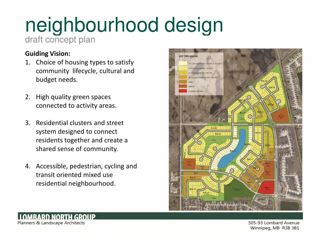
neighbourhood designdraft concept plan
Guiding Vision:
1. Choice of housing types to satisfy
community lifecycle, cultural and
budget needs.
2. High quality green spaces
connected to activity areas.
3. Residential clusters and street 3. Residential clusters and street
system designed to connect
residents together and create a
shared sense of community.
4. Accessible, pedestrian, cycling and
transit oriented mixed use
residential neighbourhood.

residential lot mixtype, average lot size and residential totals
1. R1 - L
2. R1 - M
3. R1 - S
Subtotal (SF)
57
354
79
492
(avg lot size 55x170 & 120)
(avg lot size 46x110)
(avg lot size 40x110)
1. R2
2. RMF – S
Subtotal MF - S
1. RMF - M
44
149
193
325
1,010TOTAL UNITS
(avg lot size 60x105)
(Townhouses)
4 sites (9.5ac)

High Profile lotscharacteristics
1. Walk out basement lake view
(vary between 55 and 60 ft in
width)
2. Walk out basement park view (vary
in width between 45 and 50 ft in
width)
49
70
119TOTAL UNITS

High Profile lotscharacteristics
Lot width 45-50ft Park View
Lot depth 120ft
Lot width 55-60ftLake View
Lot depth 120ft
Lot depth 170ft
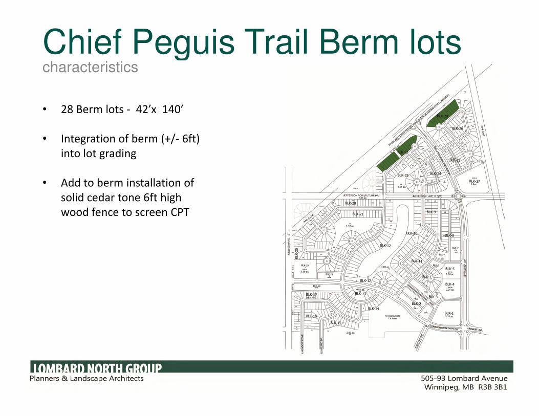
Chief Peguis Trail Berm lotscharacteristics
• 28 Berm lots - 42’x 140’
• Integration of berm (+/- 6ft)
into lot grading
• Add to berm installation of
solid cedar tone 6ft high
wood fence to screen CPTwood fence to screen CPT
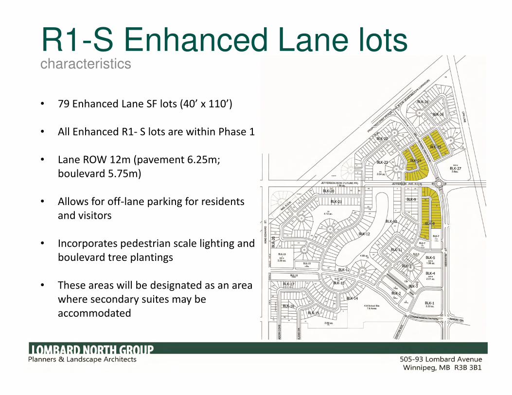
R1-S Enhanced Lane lotscharacteristics
• 79 Enhanced Lane SF lots (40’ x 110’)
• All Enhanced R1- S lots are within Phase 1
• Lane ROW 12m (pavement 6.25m;
boulevard 5.75m)
• Allows for off-lane parking for residents • Allows for off-lane parking for residents
and visitors
• Incorporates pedestrian scale lighting and
boulevard tree plantings
• These areas will be designated as an area
where secondary suites may be
accommodated

design featuresR1-S Avenue Houses with enhanced lanes (Dr. Jose Rizal Way)
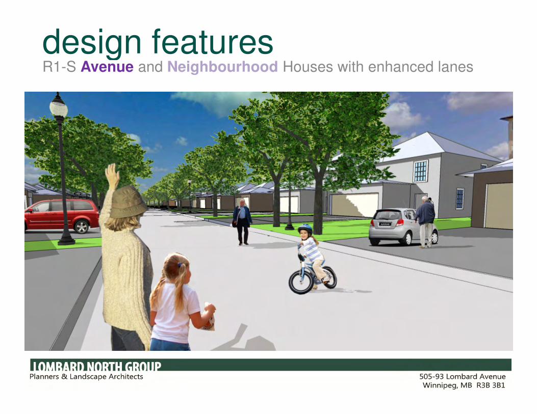
design featuresR1-S Avenue and Neighbourhood Houses with enhanced lanes
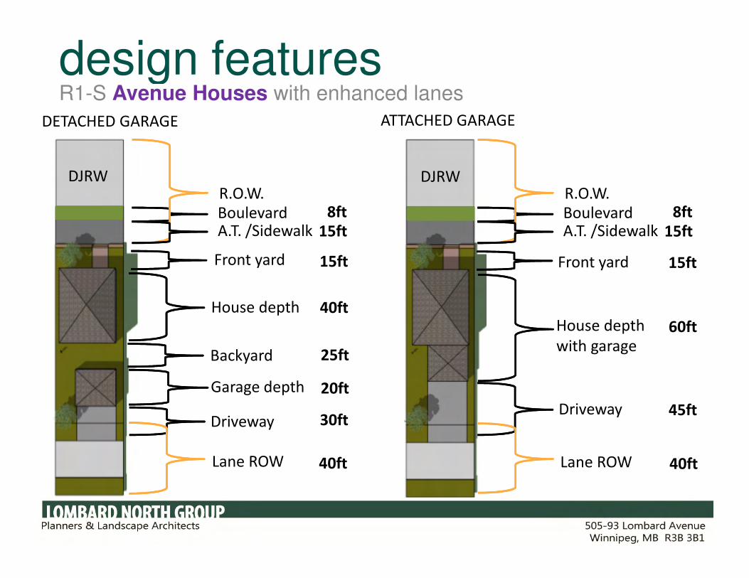
design featuresR1-S Avenue Houses with enhanced lanes
DETACHED GARAGE ATTACHED GARAGE
Boulevard
Front yard15ft 15ft
R.O.W.DJRWDJRW
Front yard
8ft Boulevard
R.O.W.8ft
A.T. /Sidewalk 15ft A.T. /Sidewalk 15ft
House depthHouse depth
with garage
Garage depth
Lane ROW
Driveway
Backyard
Driveway
40ft
25ft
20ft
30ft
60ft
45ft
40ftLane ROW 40ft

design featuresR1-S Neighbourhood Houses with enhanced lanes (secondary suite)
Front yard 20ft
House width 34ftLot width 40ftLot depth 110ft
Lane ROW
Driveway
60ft
40ft
40ft
House depth
with garage

semi-detachedcharacteristics
• Add to choice of housing by including 44
semi-detached market units
• Average lot dimensions: 60ft x 105ft
• 18 units will have lane access

townhousescharacteristics
• Townhouses are located along collector
streets or at entry gateways to help
create active streetscapes
• Townhouses may have 10ft front yards to
create a pedestrian friendly environment
• Townhouses will have articulation in
1
• Townhouses will have articulation in
facades, different roof pitches and
various materials to provide uniqueness
in design.
• Townhouses will provide opportunities
for individual ownership not part of a
condo corporation
1

design featuresRMF-S townhouses with lanes
Lane ROW
Driveway 20ft
20.5ft
Garage 22ft
Backyard 17ft
House depth
Front yard 10ft
32ft
House width 20 -24ftLot width 20- 24 ftLot depth 100 ft
Backyard 17ft

multi-family residential characteristics
• Multi-family lots are located along collector
streets or at entry gateways
• Setbacks and a stepping down of heights towards
single family residential areas to minimize
shadow impacts.
• Encourage architecturally innovative building
design that positively contributes to the
1
design that positively contributes to the
neighbourhood.
• Multi-family will range between 3 to a maximum
of 6 stories.
• MHRC reserves the right to purchase up to 3
acres of land for multi-family housing. If they do,
MHRC propose constructing market and non-
market rental, cooperative or life-lease housing
targeted to seniors 55+
1

commercial town centre designdraft concept plan

commercial town centre designdraft concept plan
Store fronts will be orientated to the
street - building setbacks will only be
permitted where it is to incorporate a
seating space, patio, etc.
Commercial signage to be pedestrian
in scale
Store front set back along Dr. Jose Rizal Way
Store fronts along Dr. Jose Rizal Way
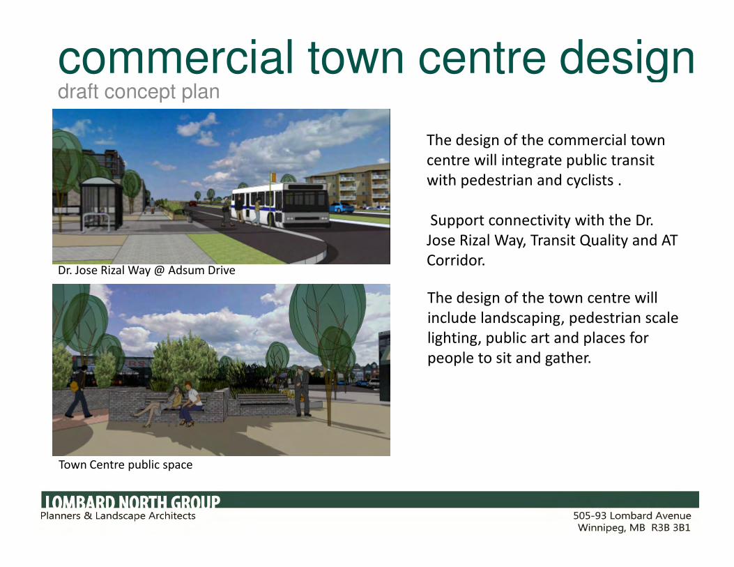
commercial town centre designdraft concept plan
The design of the commercial town
centre will integrate public transit
with pedestrian and cyclists .
Support connectivity with the Dr.
Jose Rizal Way, Transit Quality and AT
Corridor.Dr. Jose Rizal Way @ Adsum Drive
Town Centre public space
The design of the town centre will
include landscaping, pedestrian scale
lighting, public art and places for
people to sit and gather.

commercial town centre designdraft concept plan
Establish a view corridor from the
intersection of Commonwealth with
Dr. Jose Rizal Way through to the
heart of the neighbourhood , lake
and park system.
Pedestrian boulevard connecting town centre to
11
Pedestrian boulevard connecting town centre to
pathway system
Dr. Jose Rizal Way @ Adsum Drive
2
2

commercial town centre designdraft concept plan
11
Town Centre design will connect the
surrounding neighbourhood to the town
centre by creating pedestrian friendly
environment (lighting and landscaping)
with store fronts that actively engage
the street.
1
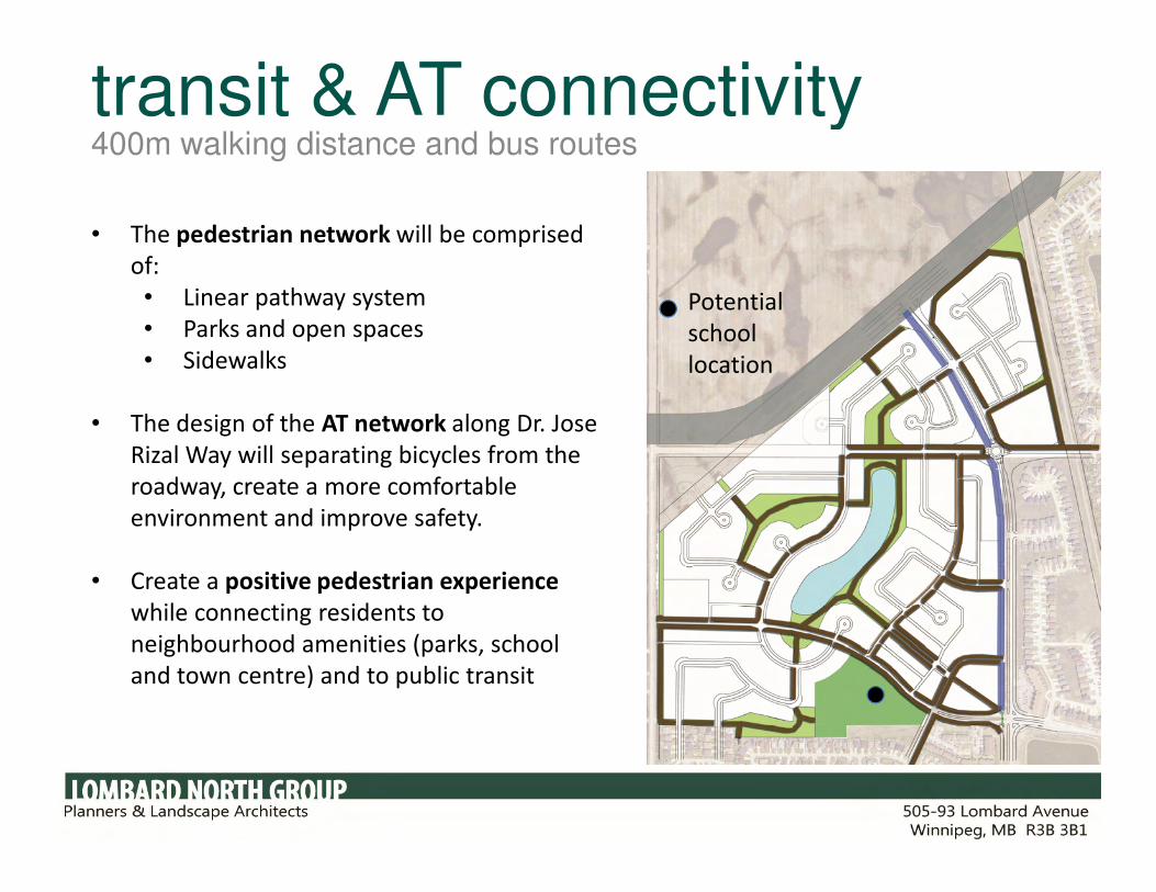
transit & AT connectivity400m walking distance and bus routes
• The pedestrian network will be comprised
of:
• Linear pathway system
• Parks and open spaces
• Sidewalks
• The design of the AT network along Dr. Jose
Rizal Way will separating bicycles from the
Potential
school
location
Rizal Way will separating bicycles from the
roadway, create a more comfortable
environment and improve safety.
• Create a positive pedestrian experience
while connecting residents to
neighbourhood amenities (parks, school
and town centre) and to public transit

transit & AT connectivity400m walking distance and bus routes
• The Transit Quality Corridor will be
supported with a variety of land uses
(residential and commercial) and by
providing strategic sidewalk connections to
Dr. Jose Rizal Way to facilitate connectivity.
Potential
school
location

transit & AT connectivity400m walking distance and bus routes
• All households in the new
neighbourhood will be within the City
of Winnipeg’s standard of 400m from
a bus route
• Bus stops will be located at natural
“hot spots” where they can support
and facilitate the use of public transit.
Potential bus
stop locations
Potential
school
location
and facilitate the use of public transit.

schedule for development approvaltimelines
1. May – June 2012 Community Committee Public Hearing
2. June – July 2012 Council Approval
3. August – Sept 2012 Development Agreement
4. October 2012 Start of servicing Phase 14. October 2012 Start of servicing Phase 1
5. August 2013 Start of first house (and possible school) construction following
completion of Phase 1 streets and underground services.

phasing planresidential units by type for phase #1
1. R1 - L
2. R1 - M
3. R1 – S
Subtotal (SF)
1. R2
31
81
79
191
18 (9 lots)1. R2
2. RMF – S
subtotal (MF-S)
1. RMF - M
18 (9 lots)
126
144
250 (3 sites = 7.17 acres)
585TOTAL UNITS
(phase #1)
thank youquestions?
Principal Contact:
David Palubeski, President Lombard North Group
Tel: 943-3896
Email: [email protected]