Embed Size (px)
Citation preview
(19) United States (12) Patent Application Publication (10) Pub. No.: US 2008/0319652 A1
US 20080319652A1
Moshfeghi (43) Pub. Date: Dec. 25, 2008
(54) NAVIGATION SYSTEMAND METHODS FOR Publication Classification MAPNAVIGATION (51) Int. Cl.
(75) I t Mehran Moshfeghi, Rancho Pal GOIC 2L/30 (2006.01) VO enran Vosnegni, Kancino Palos Verdes, CA (US) (52) U.S. Cl. ........................................................ 701A208
(57) ABSTRACT
Correspondence Address: Embodiments of the present invention include systems and FOUNTAINHEAD LAW GROUP, PC methods for improved navigation using the global positioning 900 LAFAYETTE STREET, SUITE 509 system (GPS). A method of improved navigation includes SANTACLARA, CA 95050 (US) transmitting position information from a first GPS-enabled
device to a navigation server through a wireless communica (73) Assignee: Radiofy LLC, Los Angeles, CA tion channel automatically at a time interval. The method
(US) further includes receiving mapping information from the navigation server. The mapping information corresponds to
(21) Appl. No.: 11/820,579 the position information. The method further includes out putting the mapping information. In this manner, the most
(22) Filed: Jun. 20, 2007 up-to-date navigation information is automatically available.
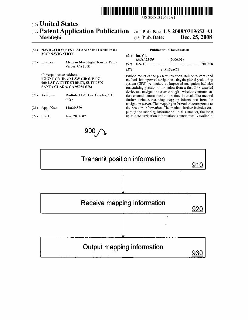
900/y
Transmit position information
Receive mapping information
Output mapping information
Patent Application Publication Dec. 25, 2008 Sheet 1 of 10 US 2008/0319652 A1
an as as a a a
Headset 160
164 Contact Databases
Calendar Databases
Navigation & Bluetooth Alert Module applications
34 Synchro
software SO
chronization as
Contact
170 Cellular Base Station
140
F.G. 1
Patent Application Publication
Databases
Calendar Databases
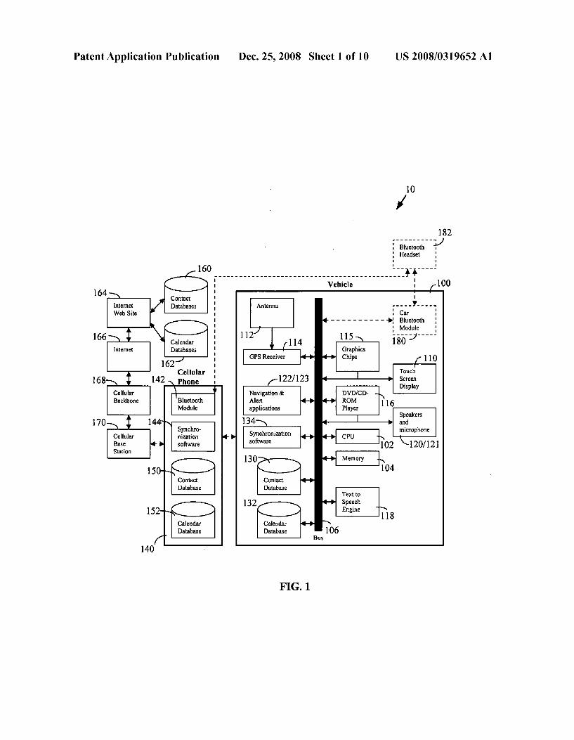
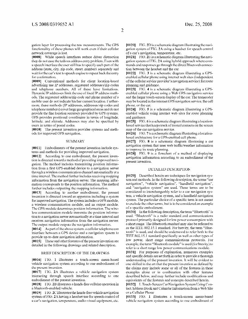
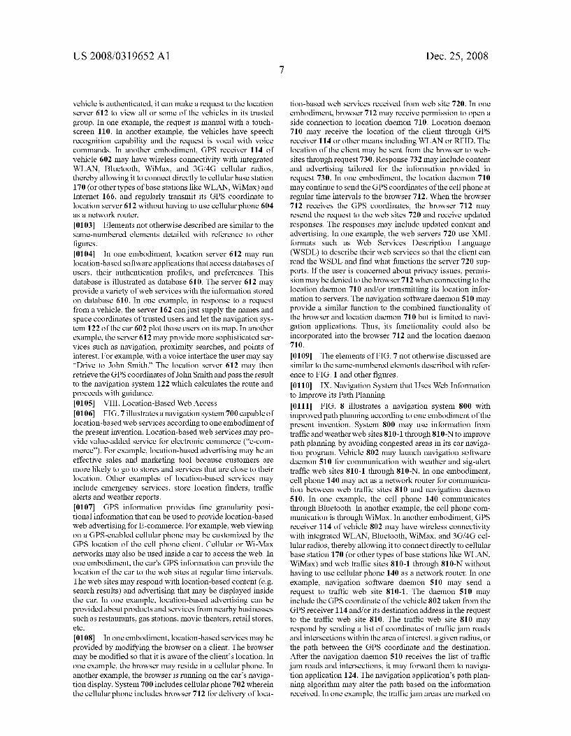
62
166
168 Cellular Phoe
142
170 Cellular Base Station
Synchro nization software
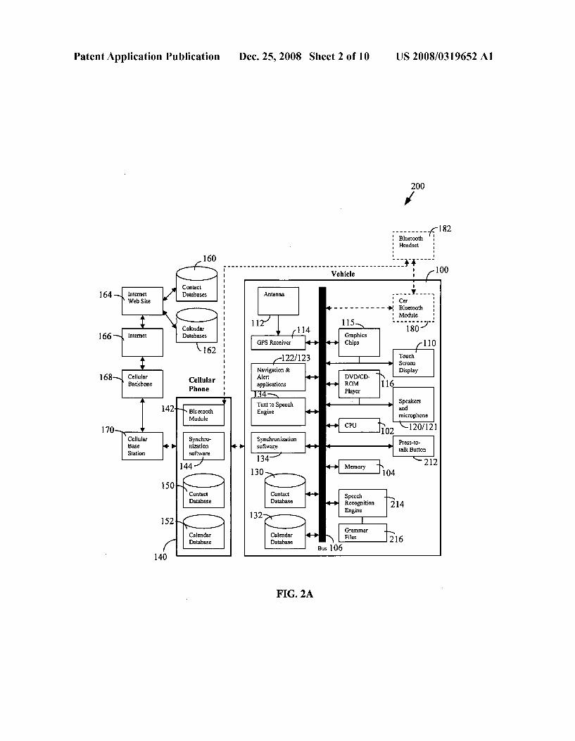
152O Calendar Database
140
GPS Receiver
122/123 Navigation & Alert applications
Text to Speech Engine
Synchronization software
134
130
FIG. 2A
Bus 106
Dec. 25, 2008 Sheet 2 of 10
Recognition Engine
Grammar Files
US 2008/0319652 A1
- a- 182
120/121
Press-to talk Button
214

Patent Application Publication Dec. 25, 2008 Sheet 3 of 10 US 2008/0319652 A1
220 A 12
Car Audio in microphone
12 O
Cellular Car Bluetooth Bluetooth Module Module
FG, 2B
Audio in Headset 142 microphone
Headset Cellular Car Speech 182-2 Bluetooth Bluetooth Bluetooth
Module Module Module Processing Audio out
240 Audio in Headset microphone
Headset Car h Bluetooth Bluetooth Speec Module Module Processing
Audio Out
FIG. 2D
182-1 250 Audio in Headset 180 A?
microphone Headset Cellular Car Speech
182-2 Bluetooth Bluetooth Bluetooth . Module Module Module Processing
Audio out
FIG. 2E
Patent Application Publication Dec. 25, 2008 Sheet 4 of 10 US 2008/0319652 A1
Contact Databases
142 Bluetooth
64 Web Speech Navigation Recognition CPU and 320
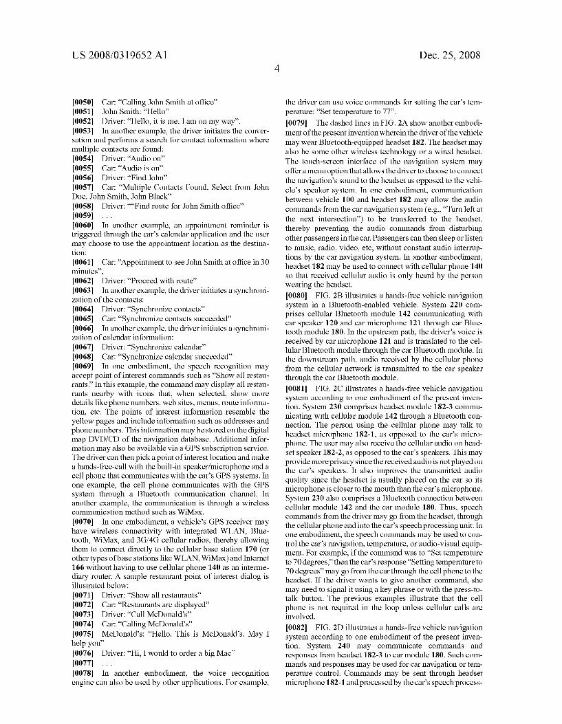
Engine Graphics Processor
166
330 Navigation Site 2
332 Navigation Site Calendar
Database
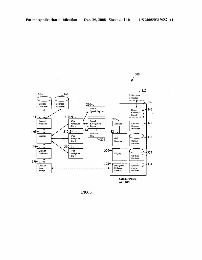
170 334 Cellular Navigation
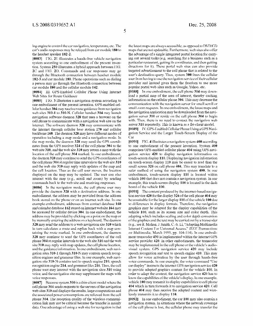
Base - - - - - - - -n - - - - - - - - - - - - - - - - - - - a - Software nization Station Daemon software
Cellular Phone with GPS
FG. 3

Patent Application Publication Dec. 25, 2008 Sheet 5 of 10 US 2008/0319652 A1
400
Calendar Databases
182 - - - - - - -4-
Bluetooth Bluetooth Module N- - - - - - - - - - - - - - - - - - Headset
160/162 - - - - - - - A
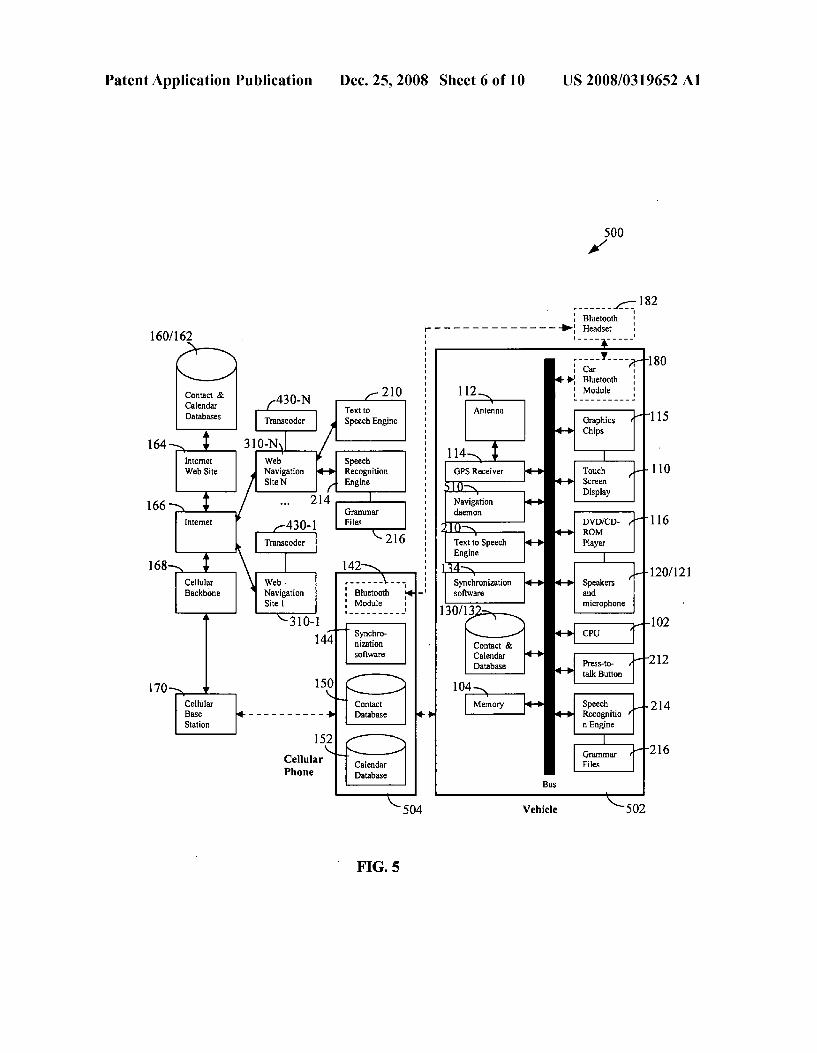
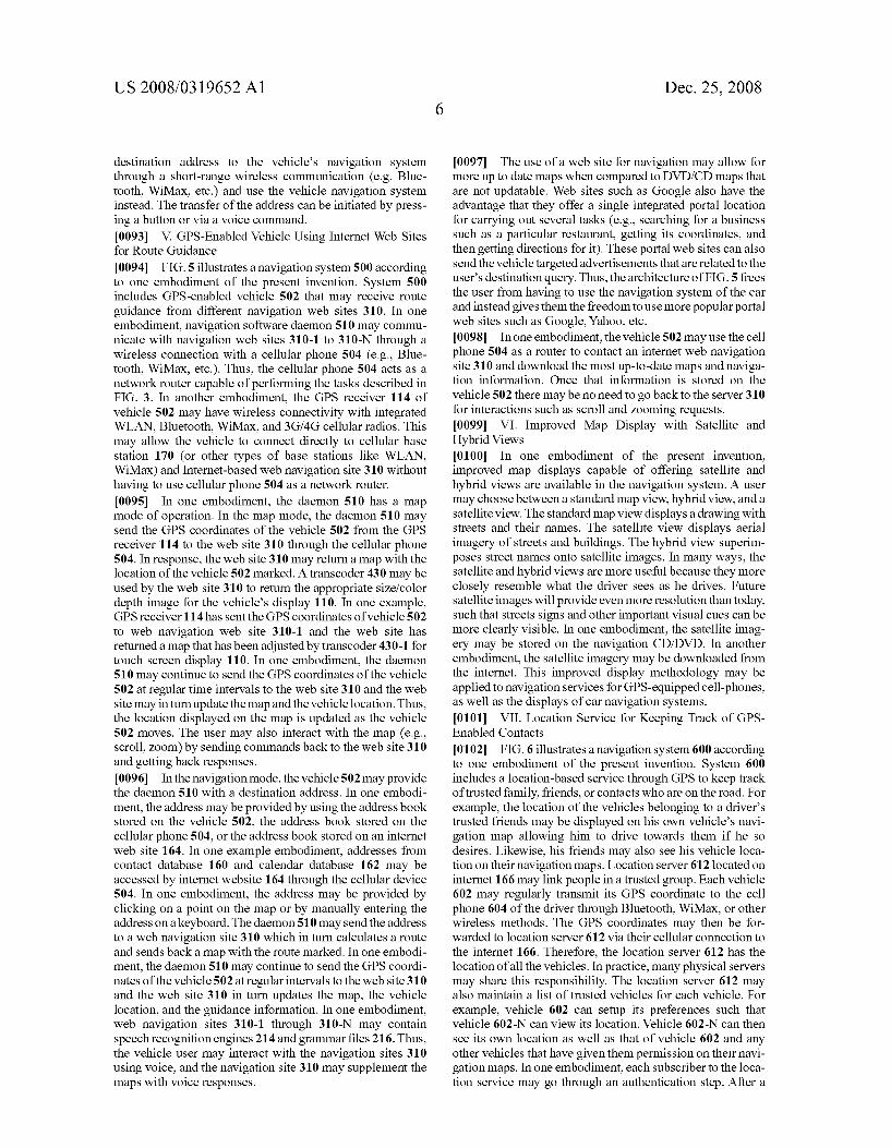
:
Contact & 100
Speech 164 Recognitio
n and Text to Speech Engine Touch Screen
Graphics Display Processor
GPS nization software
Speakers and Microphone
Navigation Service
Contact Database
170 Vehicle
Cellular Phone with GPS
FIG. 4
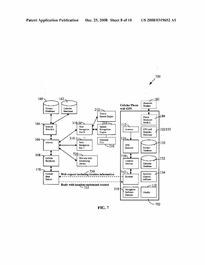
Patent Application Publication Dec. 25, 2008 Sheet 6 of 10 US 2008/0319652 A1
Bluetooth 160/162 - - - - - - - - - - - - - - ->: Headset
Contact & Calendar Databases
Speech Recognition Engine
Navigation SiteN
is DVD/CD ROM Text to Speech Player Engine
4 120/121 Speakers
softw. and
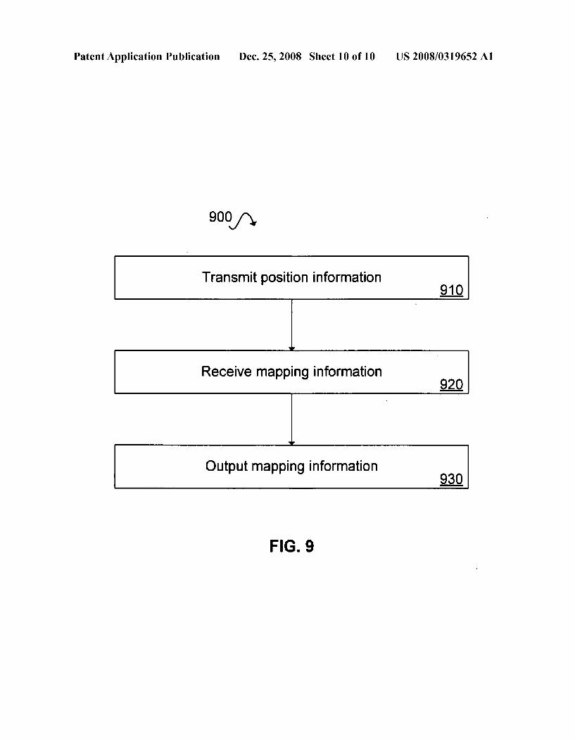
130/13 microphone
chronization are
Contact & Calendar Database
168
Navigation Sitel
Cellular Backbone
nization software
170
504 Vehicle 502
FGS

Patent Application Publication Dec. 25, 2008 Sheet 7 of 10 US 2008/0319652 A1
l
Calendar Databases
Contact Databases Bluetooth
Headset :
164
User DB with Preferences
68 Navigation & Alert applications
170
Synchro nization software
Database
604
FIG. 6
Patent Application Publication Dec. 25, 2008 Sheet 8 of 10 US 2008/0319652 A1
700
160
Contact Databases
Cellular Phone Headset with GPS - - - - - - - - - - 210
80
2 Speech Recognition Engine
164
Web Site 102/155 Navigation Site N Graphics
Processor
166 Web Navigation Site 1
168 Cellular Web site with 132 Backbone Advertising
Seryers
170 730
nization software
134
Reply with location customized content Navigation Software Daenon
FG. 7

Patent Application Publication Dec. 25, 2008 Sheet 9 of 10
160/162
Contact & Calendar Databases
Speech Recognition Engine
nization
170
Cellular Phone
FG, 8
Navigation & Alert applications
US 2008/0319652 A1
Bluetooth / ; Headset
115
Touch 110 Screen
116
Recognitio in Engine
Patent Application Publication Dec. 25, 2008 Sheet 10 of 10 US 2008/0319652 A1
Receive mapping information
Output mapping information
FIG. 9
US 2008/03 19652 A1
NAVIGATION SYSTEMAND METHODS FOR MAPNAVIGATION
BACKGROUND
0001 Global Positioning System (GPS) car navigation systems use satellites to determine the location of the car on a map and to provide route-planning and navigation guidance, thereby avoiding the need for folded paper maps and printed directions. These personal assistant systems range from expensive factory pre-installed models that include a color display in the dashboard to more affordable and compact systems that can plug in the car's cigarette lighter. The man machine interface is typically a touch-screen keypad display for inputting information and displaying maps from a data base. However, push-buttons, joysticks and dials-based inter faces are also available. Most recent systems are DVD-based, as opposed to the earlier CD-based versions that required changing map CDs for different areas of the country. The user can typically select a destination from a variety of methods Such as address, intersection, address book entry, and directly from the map. Most systems provide directions graphically and vocally. Some systems provide a 3-D capability, often called “bird’s-eye view', which can be easier to read than a 2-D map. Most navigation systems also automatically display locations of points of interest Such as airports, hotels, gas stations, movie theaters, restaurants, banks and other busi nesses. These points of interest locations can serve as possible destinations. 0002 One of the problems with navigation systems, how ever, is that the entry of a new address is often a tedious and lengthy process, during which the car has to be in park mode for safety reasons. Another problem is that the map databases and points of interest can get out of date because DVD/CDs are not updateable. The map displays are also drawings with street names as opposed to realistic images of Surrounding buildings. The navigation's audio as well as Bluetooth-en abled playback of cellular calls on the car's speakers is also annoying to passengers who want to sleep or listen to unin terrupted music, radio, video, etc. 0003. With the proliferation of cellular handsets and intro duction of GPS-enabled cellular phones it is now also pos sible to use such handsets together with a cellular GPS navi gation service to get directions. For example, Nextel offers its subscribers Motorola's ViaMoto service. The cellphone user launches an application on the Nextel handset and types in the address of the destination. The service then uses GPS and Nextel's network to send driving directions to the handset. Google has also released a version of Google Maps Mobile for devices like the Palm Treo line of smartphones, Research In Motion's BlackBerries, and many Java-capable phones from Nokia, Motorola and Sony Ericsson. Additional ser vices can also be provided Such as traffic accident alerts, weather forecasts, points of interest, merchant pricing and sales information, sharing one's location with trusted people, etc. Cellular-based GPS systems have some disadvantages, however. Entering addresses into a mobile handset is difficult because it often requires pressing a number a few times to enter the correct letter. Cellular carriers’ navigation systems are also not as comprehensive as portal web sites such as Yahoo and Google. The display of a typical cellphone is also much smaller than that of in-car navigation systems for dis play of maps and directions. More importantly, if the network coverage is lost then the navigation or map application does not work for mobile-station assisted GPS phones (i.e. phones
Dec. 25, 2008
which send their raw GPS measurement data to a server on the internet for processing, as opposed to mobile-station based phones which run the navigation layer themselves). Web searches and advertising inside a GPS-enabled car or cell phone also does not utilize the information about the position of the car/phone. Existing navigation systems use only map data but do not include up-to-date traffic and weather report information and can thus lead the user to traffic jam areas. 0004 Thus, there remains a need for a navigation system that is capable of downloading and synchronizing address or other contact information, calendar data, map data, and other data or information from cell phones, PDA's or web site portals. 0005 One of the main impediments to using car naviga tion systems (or any other moving object for that matter) is the tedious and long process of entering destination addresses on touch-screen keypad displays. Using Voice commands to enter an address is also not easy because the recognition engine has to get all parts of an address (street name, number, city, state, and Zip code) correct in the typically noisy car environment. However, we often have access to many addresses in various address books on internet web sites Such as Yahoo! Address Book on PDAs and cell phones. For example, Palm offers convergence devices that are phones as well as PDAs with contact and calendar functionality. Such devices also come with synchronization software that will compare contacts and appointments on the device with those on a central database and keep them in agreement. 0006 Generally, navigation systems allow manual entry and storage of a limited number of addresses. However, manual entry of destination addresses and manipulating dials while driving often decreases the driver's ability to drive safely. Because of this liability, navigation systems may not allow manual entry of addresses if the car is in motion. Speech interfaces allow drivers to keep their hands on the wheel and minimize driver distraction. Speech interfaces have been introduced into a number of automobiles for navigation and entertainment systems (e.g., see M. J. Hunt, “Some experi ence in in-car speech recognition', IEEE Colloquium on Interactive Dialogue Systems for Telephony Applications, 1999; and A. L. Kun, W. T. Miller III, A. Pelhe, R. L. Lynch, 'A Software architecture Supporting in-car speech interac tion', IEEE Intelligent Vehicles Symposium, Jun. 14-17, 2004, pp. 471-476). These speech systems are not natural conversational speech processing but instead resemble Voice buttons that are based on a fixed grammar for particular task domains. This is sufficient for navigation applications where the task are well defined such as looking up addresses, finding points of interest, and route planning. However, the proposed method can also be used with natural language processing engines (e.g., see L. Cavedon et. al., “Developing a Conver sational In-Car Dialog System’. In the 12th International Congress on Intelligent Transportation Systems, San Fran cisco Calif., USA, 2005). 0007. There are two types of GPS-enabled phones. Most of today’s GPS-enabled phones are mobile-station assisted. These phones take their raw GPS measurements (e.g., pseudo ranges, pseudo Doppler, time, etc.) and send them to a server on the internet for calculating values such as position and velocity. The GPS functionality of these phones will not work if their cellular network coverage is lost because they will no longer be able to connect to the internet. Some of the next generation phones, however, will be mobile-station based where they have their own GPS receiver that runs the navi
US 2008/03 19652 A1
gation layer for processing the raw measurements. The GPS functionality of these phones will work even if their cellular network coverage is lost. 0008 While speech interfaces reduce driver distraction they do not ease the tedious address entry problem. Even with a speech interface the user still has to specify each part of the address (state, city, Zip code, Street, number) separately and wait for the car's text to speech engine to repeat back the entry for confirmation. 0009 Conventional methods for client location-based advertising use IP addresses, registered addresses/Zip codes and telephone numbers. All of these have limitations. Dynamic IP addresses limit the use offixed IP address meth ods. The registered address/Zip code and phone number of a mobile user do not indicate his/her current location. Further more, these methods (IP addresses, addresses/Zip codes and telephone numbers) cover large geographical areas and do not provide the fine location accuracy provided by GPS systems. GPS provides positional coordinates in terms of longitude, latitude, and altitude. Addresses may also be specified by users in terms of postal codes. 0010. The present invention provides systems and meth ods for improved GPS navigation.
SUMMARY
0011 Embodiments of the present invention include sys tems and methods for providing improved navigation. 0012. According to one embodiment, the present inven tion is directed toward a method of providing improved navi gation. The method includes transmitting position informa tion from a first GPS-enabled device to a navigation server through a wireless communication channel automatically at a time interval. The method further includes receiving mapping information from the navigation server. The mapping infor mation corresponds to the position information. The method further includes outputting the mapping information. 0013. According to another embodiment, the present invention is directed toward an apparatus including a system for improved navigation. The system includes a GPS module, a wireless communication module, and an output module. The GPS module determines position information. The wire less communication module transmits the position informa tion to a navigation server automatically at a time interval and receives navigation information from the navigation server. The output module outputs the navigation information. 0014. As part of the above system, a cellular telephone can interface between a GPS device and a navigation system to provide up-to-date navigation information. 0015 These and other features of the present invention are detailed in the following drawings and related description.
BRIEF DESCRIPTION OF THE DRAWINGS
0016 FIG. 1 illustrates a touch-screen menu-based vehicle navigation system according to one embodiment of the present invention. 0017 FIG. 2A illustrates a vehicle navigation system interacting through speech interface according to one embodiment of the present invention. 0018 FIG.2B illustrates a hands-free cellular operation in a bluetooth-enabled vehicle. 0019 FIG.2C illustrates the hands-free vehicle navigation system of FIG. 2A having a headset use for speech control of a car's navigation, temperature, audio-visual equipment, etc.
Dec. 25, 2008
0020 FIG. 2D is a schematic diagram illustrating the navi gation system of FIG. 2A using a headset for speech control of a car's navigation, temperature, etc. 0021 FIG.2E is a schematic diagram illustrating the navi gation system of FIG. 2A using hybrid approach where com mands and responses go through the direct Bluetooth connec tion between the headset and the car. 0022 FIG. 3 is a schematic diagram illustrating a GPS enabled cellular phone using internet web sites (independent of the cellular service provider's navigation service) for route planning and guidance. 0023 FIG. 4 is a schematic diagram illustrating a GPS enabled cellular phone using a Web GPS navigation service and the larger touch-screen display of the car. The transcoder may be located in the internet GPS navigation service, the cell phone, or the car. 0024 FIG. 5 is a schematic diagram illustrating a GPS enabled vehicle using internet web sites for route planning and guidance. 0025 FIG. 6 is a schematic diagram illustrating a location based service that keeps track of trusted contacts on the Screen map of the car navigation service. 0026 FIG. 7 is a schematic diagram illustrating a location based architecture for a GPS-enabled cell phone. 0027 FIG. 8 is a schematic diagram illustrating a car navigation system that uses web traffic/weather information to improve its route planning. 0028 FIG. 9 is a flowchart of a method of displaying navigation information according to an embodiment of the present invention.
DETAILED DESCRIPTION
0029 Described herein are techniques for navigation sys tem and methods. In the following description, the terms “car navigation', 'vehicle navigation”, “handheld navigation'. and “navigation system” are used. These terms are to be considered to interchangeably refer to a car navigation sys tem, a vehicle navigation system, and a handheld navigation system. The particular choice of a specific term is not meant to exclude the other terms, but is to be considered an example of a specific embodiment. 0030. In the following description, the term “Bluetooth” is used. "Bluetooth' is a radio standard and communications protocol primarily designed for low power consumption with a short range. The Bluetooth standard may also be referred to as the IEEE 802.15.1 standard. For brevity, the term “Blue tooth' is used, and should be understood to refer both to the IEEE 802.15.1 standard specifically as well as other types of low power, short range communications protocols. For example, the term “Bluetooth module' is used (for brevity) to refer to a short range low power communications module. 0031. For purposes of explanation, numerous examples and specific details are set forth in order to provide a thorough understanding of the present invention. It will be evident to one skilled in the art that the present invention as defined by the claims may include some or all of the features in these examples alone or in combination with other features described below, and may further include modifications and equivalents of the features and concepts described herein. 0032 I. Touch-Screen Car Navigation System Using Con tact Address Book and Calendar Information from a Web Site or a Cellular Phone 0033 FIG. 1 illustrates a touch-screen menu-based vehicle navigation system according to one embodiment of

US 2008/03 19652 A1
the present invention. Vehicle navigation system 10 includes antenna 112, GPS receiver 114, DVD/CD-ROM player 116, touch-screen display 110, graphics chip 115, text-to-speech engine 118, speakers 120, microphone 121, navigation appli cation 122, alert generation application 123, Synchronization software 134, contact database 130, calendar database 132, CPU 102 and memory 104. Other elements shown in FIG. 1 are described in other figures, with corresponding elements having the same element number. 0034. In one embodiment, calendar database 130 may be combined with alert generation application 123 to remind the user about upcoming appointments and tasks. These appoint ments and tasks may be integrated with navigation applica tion 122. For example, the navigation application may be able to inform the user of meeting with John Smith in 30 minutes and include a planned route shown on the display. It should be noted that the address book, calendar, and alert application are independent of the navigation and guidance system and can be used for other applications as well (e.g. making phone calls). 0035 Navigation system 10 may have a large permanent database for storing contact information that includes the contact’s address as well as other pertinent information. Per tinent information may include contact name, job title, work address, company web site, work phone, work email, home address, personal email, home phone, messenger ID, personal web site, picture, birthday, comments, and custom informa tion. In one embodiment, the latest contact information data base as well as the calendar database can be seamlessly loaded into the vehicle with use of synchronization software 134. A user may download address books from internet web sites and/or mobile devices into the vehicle and synchronize them with existing contact information. In one example, con tact database 160 and calendar database 162 may be down loaded from internet web site 164 to the cellular phone and synchronized with contact database 150 and calendar data base 152. In another example, contact database 160 and cal endar database 162 may be downloaded from internet web site 164 to the vehicle and synchronized with contact database 130 and calendar database 132. The user may also recall an address with the use of keyword association. For example, selection of the contact name “John Smith' in the contact database of the vehicle retrieves the stored contact informa tion. This contact information may include his address and phone number. Single touch screen buttons on the navigation unit such as “Find route to work address' or “Call work” may be used to perform common tasks with the stored contact information. In other embodiments of the present invention, these commands may be replaced with Voice commands. 0036. The synchronization step may include downloading the latest database from the SIM card or memory of a mobile device such as a cell phone or PDA that is in the driver's pocket, briefcase, or car's glove box compartment. For example, contact database 150 and calendar database 152 maybe downloaded from the cellular phone to the vehicle and synchronized with contact database 130 and calendar data base 132. In one embodiment, only the delta changes since the last synchronization are downloaded. The communication between the mobile device and the car can be wireless with technologies such as Bluetooth, Wireless LAN, Ultra-Wide Band (UWB), WiMax, Zigbee, or other ad-hoc/mesh network technologies. The communication may also be via a patch cord or other wired connection. In another embodiment, the synchronization step includes downloading address and con
Dec. 25, 2008
tact information from internet web sites. In one example, address and contact information is downloaded from Yahoo! Address Book and Yahoo Calendar. In one embodiment, the mobile device is used as an intermediary to log into the web site, download the latest databases, and transmit the informa tion wirelessly to the car. Some vehicles may also include integrated cellular phones to be used as either the source of the contact information for download or as an intermediary to connect to the internet web sites. Some vehicles GPS receiv ers may have wireless connectivity with integrated WLAN, Bluetooth, WiMax, and 3G/4G cellular radios. Such vehicles may connect directly to cellular base station 170 (or other types of base stations like WLAN, WiMax) and Internet 166 without having to use a cellular phone 140 as an intermediary router. For addresses of interest which are not in any of the databases, data entry of the addresses may be simplified by entering the addresses into an internet web site's database on a desktop computer through a conventional size keyboard and then downloading them to the phone or the vehicle. 0037. The synchronization step may be necessary if there has been a change to the contact databases. In one embodi ment, synchronization may be initiated via a menu command button on the phone. In another embodiment, synchronization may be programmed as an automatic background process that does not require any action by the user. Synchronization may also be bi-directional. Most address books and calendar pro grams provide an export functionality that may generate a Comma Separated Value (CSV) file, html/xml file, or some other format. Likewise, data may be imported to the address books and calendar programs through the same format. Therefore, if new contacts or calendar events have been entered directly into the vehicle, then the synchronization step may also make those entries available on the cellular phone or the internet web site by exporting them from the vehicle. 0038 II. Speech Interface Car Navigation System Using Contact Address Book and Calendar Information from a Web Site or a Cellular Phone 0039 FIG. 2A illustrates a vehicle navigation system interacting through speech interface according to one embodiment of the present invention. Combining a speech interface with address book and calendar databases may be used to avoid manual address entry in the car whenever pos sible. Vehicle navigation system 200 includes microphone 121, speech recognition engine 214, grammar files 216, and press-to-talk button 212. Different grammar files can be loaded by the speech recognition engine based on the context of the previous commands. For example, if the user is at the stage of using speech to enter the Street number of an address then the grammar file containing alphanumeric characters (26 letter plus numbers from 0 to 9) is used. The other elements are as described in FIG. 1 and the remaining figures. 0040 Below is an example interaction where the driver initiates the conversation and the vehicle provided feedback to the driver: 0041 Driver: “Audio on 0042 Car: “Audio is on 0043. Driver: “Find route for John Smith office' 0044 Car: “Route found 0045 Driver: “Proceed with route' 0046 Car: "Guidance information . . .” 0047. Driver: “Zoom” 0048 Car: "Zoomed the map' 0049 Driver: “Call John Smith at office'
US 2008/03 19652 A1
0050 Car: “Calling John Smith at office' 0051 John Smith: “Hello” 0052 Driver: “Hello, it is me. I am on my way”. 0053. In another example, the driver initiates the conver sation and performs a search for contact information where multiple contacts are found: 0054 Driver: “Audio on 0055 Car: “Audio is on 0056 Driver: “Find John 0057 Car: “Multiple Contacts Found. Select from John Doe, John Smith, John Black' 0058 Driver: “Find route for John Smith office' 0059 0060. In another example, an appointment reminder is triggered through the car's calendar application and the user may choose to use the appointment location as the destina tion: 0061 Car: “Appointment to see John Smith at office in 30 minutes'. 0062 Driver: “Proceed with route' 0063. In another example, the driver initiates a synchroni Zation of the contacts: 0064 Driver: “Synchronize contacts” 0065 Car: “Synchronize contacts succeeded 0066. In another example, the driver initiates a synchroni Zation of calendar information: 0067. Driver: “Synchronize calendar’ 0068 Car: “Synchronize calendar succeeded 0069. In one embodiment, the speech recognition may accept point of interest commands such as "Show all restau rants. In this example, the command may display all restau rants nearby with icons that, when selected, show more details like phone numbers, web sites, menus, route informa tion, etc. The points of interest information resemble the yellow pages and include information Such as addresses and phone numbers. This information may be stored on the digital map DVD/CD of the navigation database. Additional infor mation may also be available via a GPS subscription service. The driver can then pick a point of interest location and make a hands-free-call with the built-in speaker/microphone and a cellphone that communicates with the car’s GPS systems. In one example, the cell phone communicates with the GPS system through a Bluetooth communication channel. In another example, the communication is through a wireless communication method such as WiMax. 0070. In one embodiment, a vehicle's GPS receiver may have wireless connectivity with integrated WLAN, Blue tooth, WiMax, and 3G/4G cellular radios, thereby allowing them to connect directly to the cellular base station 170 (or other types of base stations like WLAN, WiMax) and Internet 166 without having to use cellular phone 140 as an interme diary router. A sample restaurant point of interest dialog is illustrated below: (0071. Driver: “Show all restaurants' 0072 Car: “Restaurants are displayed” 0073 Driver: “Call McDonald's” 0074 Car: “Calling McDonald's 0075 McDonald's: “Hello. This is McDonald's. May I help you' 0076. Driver: "Hi, I would to order a big Mac' 0.077 0078. In another embodiment, the voice recognition engine can also be used by other applications. For example,
Dec. 25, 2008
the driver can use voice commands for setting the car's tem perature: “Set temperature to 77. 007.9 The dashed lines in FIG. 2A show another embodi ment of the present invention wherein the driver of the vehicle may wear Bluetooth-equipped headset 182. The headset may also be some other wireless technology or a wired headset. The touch-screen interface of the navigation system may offer a menu option that allows the driver to choose to connect the navigation's Sound to the headset as opposed to the vehi cle's speaker system. In one embodiment, communication between vehicle 100 and headset 182 may allow the audio commands from the car navigation system (e.g., "Turn left at the next intersection') to be transferred to the headset, thereby preventing the audio commands from disturbing other passengers in the car. Passengers can then sleep or listen to music, radio, video, etc., without constant audio interrup tions by the car navigation system. In another embodiment, headset 182 may be used to connect with cellular phone 140 so that received cellular audio is only heard by the person wearing the headset. 0080 FIG. 2B illustrates a hands-free vehicle navigation system in a Bluetooth-enabled vehicle. System 220 com prises cellular Bluetooth module 142 communicating with car speaker 120 and car microphone 121 through car Blue tooth module 180. In the upstream path, the driver's voice is received by car microphone 121 and is translated to the cel lular Bluetooth module through the car Bluetooth module. In the downstream path, audio received by the cellular phone from the cellular network is transmitted to the car speaker through the car Bluetooth module. I0081 FIG. 2C illustrates a hands-free vehicle navigation system according to one embodiment of the present inven tion. System 230 comprises headset module 182-3 commu nicating with cellular module 142 through a Bluetooth con nection. The person using the cellular phone may talk to headset microphone 182-1, as opposed to the car's micro phone. The user may also receive the cellular audio on head set speaker 182-2, as opposed to the car's speakers. This may provide more privacy since the received audio is not played on the car's speakers. It also improves the transmitted audio quality since the headset is usually placed on the ear So its microphone is closer to the mouth than the car's microphone. System 230 also comprises a Bluetooth connection between cellular module 142 and the car module 180. Thus, speech commands from the driver may go from the headset, through the cellular phone and into the car's speech processing unit. In one embodiment, the speech commands may be used to con trol the car's navigation, temperature, or audio-visual equip ment. For example, if the command was to “Set temperature to 70 degrees, then the car's response “Setting temperature to 70 degrees” may go from the carthrough the cellphone to the headset. If the driver wants to give another command, she may need to signal it using a key phrase or with the press-to talk button. The previous examples illustrate that the cell phone is not required in the loop unless cellular calls are involved.
I0082 FIG. 2D illustrates a hands-free vehicle navigation system according to one embodiment of the present inven tion. System 240 may communicate commands and responses from headset 182-3 to car module 180. Such com mands and responses may be used for car navigation or tem perature control. Commands may be sent through headset microphone 182-1 and processed by the car's speech process
US 2008/03 19652 A1
ing engine to control the car navigation, temperature, etc. The car's audio responses may be relayed from car module 180 to the headset speaker 182-2. 0083 FIG. 2E illustrates a hands-free vehicle navigation system according to one embodiment of the present inven tion. System 250 illustrates a hybrid approach between FIG. 2C and FIG. 2D. Commands and car responses may go through the Bluetooth connection between headset module 182-3 and car module 180. Phone operations such as dialing a person may go through the Bluetooth connection between car module 180 and the cellular module 142.
I0084 III. GPS-Enabled Cellular Phone Using Internet Web Sites for Route Guidance 0085 FIG. 3 illustrates a navigation system according to one embodiment of the present invention. GPS-enabled cel lular handset 304 may receive route guidance from navigation web sites 310-1 to 310-N. Cellular handset 304 may launch navigation software daemon 328 that uses a browser on the cellphone to communicate with a navigation web site on the internet. The software daemon 328 may communicate with the internet through cellular base station 170 and cellular backbone 168. The daemon 328 may have different modes of operation including a map mode and a navigation mode. In the map mode, the daemon 328 may send the GPS coordi nates from the GPS receiver 324 of the cellphone 304 to the web site 310, and the web site 310 may return a map with the location of the cell phone 304 marked. In one embodiment, the daemon 328 may continue to send the GPS coordinates of the cellphone 304 at regular time intervals to the web site 310 and the web site 310 may reply with updates of the map and the cell location. Thus as the cell user moves, the location displayed on the map may be updated. The user can also interact with the map (e.g., scroll and Zoom) by sending commands back to the web site and receiving responses. I0086. In the navigation mode, the cell phone user may provide the daemon 328 with a destination address. In one embodiment, the address may be provided from the address book stored on the phone or on an internet web site. In one example embodiment, addresses from contact database 160 and calendar database 162 stored on internet website 164 may be accessed by cellular device 304. In one embodiment, the address may be provided by clicking on a point on the map or by manually entering the address on a keyboard. The daemon 328 may send the address to a web navigation site 310 which in turn calculates a route and replies back with a map con taining the route marked. In one embodiment, the daemon 328 may continue to send the GPS coordinates of the cell phone 304 at regular intervals to the web site 310 and the web site 310 may reply with map updates, the cellphone location, and the guidance information. In one embodiment, web navi gation sites 310-1 through 310-N may contain speech recog nition engines and grammar files. In one example, web navi gation site 310-N contains text to speech engine 210, speech recognition engine 214, and grammar files 216. Thus, the cell phone user may interact with the navigation sites 310 using Voice, and the navigation site may supplement the maps with Voice responses. I0087. Because system300 is a thin-client model where the cellphone 304 sends requests to the servers of the navigation web sites 310 and displays the results, large computations and the associated power consumptions are relieved from the cell phone 304. The reception quality of the wireless communi cation link may not be critical because the transfer is mainly data. One advantage of using a web site for navigation is that
Dec. 25, 2008
the latest maps are always accessible, as opposed to DVD/CD maps that are not updatable. Furthermore, web sites also offer the advantage of a single integrated portal location for carry ing out several tasks (e.g. searching for a business Such as a particular restaurant, getting its coordinates, and then getting directions for it). These portal web sites can also provide targeted advertisement to the cell phone that is related to the user's destination query. Thus, system 300 frees the cellular user from having to use the navigation service of their cellular provider and instead gives them the freedom to use more popular portal web sites Such as Google, Yahoo, etc. I0088. In one embodiment, the cell phone 304 may down load a partial map of the area of interest, thereby caching information on the cellular phone 304. This may decrease the communication with the navigation server for Small Scroll or Small Zoom requests. In one embodiment, the latest maps and the navigation application may be downloaded from the navi gation server 310 or reside on the cell phone 304 to begin with. Thus, there is no need to contact the navigation web server 310 repeatedly. This is known as a fat-client model. I0089. IV. GPS-Enabled Cellular Phone Using a GPS Navi gation Service and the Larger Touch-Screen Display of the Car 0090 FIG. 4 illustrates a navigation system 400 according to one embodiment of the present invention. System 400 comprises GPS-enabled cellular phone 404 using GPS navi gation service 420 to display navigation information on touch-screen display 110. Displaying navigation information on touch-screen display 110 may be easier to read than the small screen 326 on cell phone 404. This may translate to a safer method of using the navigation system 400. In one embodiment, touch-screen display 110 is located within vehicle 100 that does not contain a navigation system. In one example, this touch-screen display 110 is located in the dash board of the vehicle 100. 0091. The content produced by the internet-based naviga tion service 420 for the display 326 of the cellphone 404 may be unsuitable for the larger display 110 of the vehicle 100 due to differences in display formats. Therefore, the navigation graphics may be adapted for the display capabilities of the vehicle 100, such as its screen size and color depth. This adapting which includes scaling and color depth conversion of the graphics and the text may be carried out by a transcoder (e.g., see R. Mohan, J. Smith, C.-S. Li, Adapting Multimedia Internet Content For Universal Access.” IEEE Transactions on Multimedia, March 1999, pp. 104-114). In one embodi ment transcoder 430 is implemented within the internet GPS service provider 420. In other embodiments, the transcoder may be implemented in the cell phone or the vehicle's audio visual system. GPS navigation service 420 may include speech recognition and text to speech engine 410. This may allow for voice activation by the user through hands-free Voice commands. In one example, the Voice command "Use car display” instructs the internet GPS navigation service 420 to provide adapted graphics content for the vehicle 100. In order to adapt the content, the navigation service 420 has to know the capabilities of the vehicle's display. In one example, vehicle 100 may transmit its display capabilities to cellphone 404 which in turn forwards it to navigation service 420. Cell phone 404 may then receive the adapted content and wire lessly transmits it to display 110. 0092. In one embodiment, the car 100 may also contain a navigation system. In situations where the network coverage of the cell phone is lost, the cellular phone may transfer the
US 2008/03 19652 A1
destination address to the vehicle's navigation system through a short-range wireless communication (e.g. Blue tooth, WiMax, etc.) and use the vehicle navigation system instead. The transfer of the address can be initiated by press ing a button or via a Voice command. 0093. V. GPS-Enabled Vehicle Using Internet Web Sites for Route Guidance 0094 FIG.5 illustrates a navigation system 500 according
to one embodiment of the present invention. System 500 includes GPS-enabled vehicle 502 that may receive route guidance from different navigation web sites 310. In one embodiment, navigation software daemon 510 may commu nicate with navigation web sites 310-1 to 310-N through a wireless connection with a cellular phone 504 (e.g., Blue tooth, WiMax, etc.). Thus, the cellular phone 504 acts as a network router capable of performing the tasks described in FIG. 3. In another embodiment, the GPS receiver 114 of vehicle 502 may have wireless connectivity with integrated WLAN, Bluetooth, WiMax, and 3G/4G cellular radios. This may allow the vehicle to connect directly to cellular base station 170 (or other types of base stations like WLAN, WiMax) and Internet-based web navigation site 310 without having to use cellular phone 504 as a network router. 0095. In one embodiment, the daemon 510 has a map mode of operation. In the map mode, the daemon 510 may send the GPS coordinates of the vehicle 502 from the GPS receiver 114 to the web site 310 through the cellular phone 504. In response, the web site 310 may return a map with the location of the vehicle 502 marked. A transcoder 430 may be used by the web site 310 to return the appropriate size/color depth image for the vehicle's display 110. In one example, GPS receiver 114 has sent the GPS coordinates of vehicle 502 to web navigation web site 310-1 and the web site has returned a map that has been adjusted by transcoder 430-1 for touch screen display 110. In one embodiment, the daemon 510 may continue to send the GPS coordinates of the vehicle 502 at regular time intervals to the web site 310 and the web site may in turn update the map and the vehicle location. Thus, the location displayed on the map is updated as the vehicle 502 moves. The user may also interact with the map (e.g., scroll, Zoom) by sending commands back to the web site 310 and getting back responses. 0096. In the navigation mode, the vehicle 502 may provide the daemon 510 with a destination address. In one embodi ment, the address may be provided by using the address book stored on the vehicle 502, the address book stored on the cellular phone 504, or the address book stored on an internet web site 164. In one example embodiment, addresses from contact database 160 and calendar database 162 may be accessed by internet website 164 through the cellular device 504. In one embodiment, the address may be provided by clicking on a point on the map or by manually entering the address on a keyboard. The daemon 510 may send the address to a web navigation site 310 which in turn calculates a route and sends back a map with the route marked. In one embodi ment, the daemon 510 may continue to send the GPS coordi nates of the vehicle 502 at regular intervals to the web site 310 and the web site 310 in turn updates the map, the vehicle location, and the guidance information. In one embodiment, web navigation sites 310-1 through 310-N may contain speech recognition engines 214 and grammar files 216. Thus, the vehicle user may interact with the navigation sites 310 using Voice, and the navigation site 310 may supplement the maps with voice responses.
Dec. 25, 2008
0097. The use of a web site for navigation may allow for more up to date maps when compared to DVD/CD maps that are not updatable. Web sites such as Google also have the advantage that they offer a single integrated portal location for carrying out several tasks (e.g., searching for a business Such as a particular restaurant, getting its coordinates, and then getting directions for it). These portal web sites can also send the vehicle targeted advertisements that are related to the user's destination query. Thus, the architecture of FIG.5 frees the user from having to use the navigation system of the car and instead gives them the freedom to use more popular portal web sites Such as Google, Yahoo, etc. (0098. In one embodiment, the vehicle 502 may use the cell phone 504 as a router to contact an internet web navigation site 310 and download the most up-to-date maps and naviga tion information. Once that information is stored on the vehicle 502 there may be no need to go back to the server 310 for interactions such as scroll and Zooming requests. (0099 VI. Improved Map Display with Satellite and Hybrid Views 0100. In one embodiment of the present invention, improved map displays capable of offering satellite and hybrid views are available in the navigation system. A user may choose between a standard map view, hybrid view, and a satellite view. The standard map view displays a drawing with streets and their names. The satellite view displays aerial imagery of Streets and buildings. The hybrid view Superim poses street names onto satellite images. In many ways, the satellite and hybrid views are more useful because they more closely resemble what the driver sees as he drives. Future satellite images will provide even more resolution than today, Such that streets signs and other important visual cues can be more clearly visible. In one embodiment, the satellite imag ery may be stored on the navigation CD/DVD. In another embodiment, the satellite imagery may be downloaded from the internet. This improved display methodology may be applied to navigation services for GPS-equipped cell-phones, as well as the displays of car navigation systems. 0101 VII. Location Service for Keeping Track of GPS Enabled Contacts 0102 FIG. 6 illustrates a navigation system 600 according to one embodiment of the present invention. System 600 includes a location-based service through GPS to keep track of trusted family, friends, or contacts who are on the road. For example, the location of the vehicles belonging to a driver's trusted friends may be displayed on his own vehicle's navi gation map allowing him to drive towards them if he so desires. Likewise, his friends may also see his vehicle loca tion on their navigation maps. Location server 612 located on internet 166 may link people in a trusted group. Each vehicle 602 may regularly transmit its GPS coordinate to the cell phone 604 of the driver through Bluetooth, WiMax, or other wireless methods. The GPS coordinates may then be for warded to location server 612 via their cellular connection to the internet 166. Therefore, the location server 612 has the location of all the vehicles. In practice, many physical servers may share this responsibility. The location server 612 may also maintain a list of trusted vehicles for each vehicle. For example, vehicle 602 can setup its preferences such that vehicle 602-N can view its location. Vehicle 602-N can then see its own location as well as that of vehicle 602 and any other vehicles that have given them permission on their navi gation maps. In one embodiment, each Subscriber to the loca tion service may go through an authentication step. After a
US 2008/03 19652 A1
vehicle is authenticated, it can make a request to the location server 612 to view all or some of the vehicles in its trusted group. In one example, the request is manual with a touch screen 110. In another example, the vehicles have speech recognition capability and the request is vocal with Voice commands. In another embodiment, GPS receiver 114 of vehicle 602 may have wireless connectivity with integrated WLAN, Bluetooth, WiMax, and 3G/4G cellular radios, thereby allowing it to connect directly to cellular base station 170 (or other types of base stations like WLAN, WiMax) and Internet 166, and regularly transmit its GPS coordinate to location server 612 without having to use cellular phone 604 as a network router.
0103 Elements not otherwise described are similar to the same-numbered elements detailed with reference to other figures. 0104. In one embodiment, location server 612 may run location-based software applications that access databases of users, their authentication profiles, and preferences. This database is illustrated as database 610. The server 612 may provide a variety of web services with the information stored on database 610. In one example, in response to a request from a vehicle, the server 162 can just Supply the names and space coordinates of trusted users and let the navigation sys tem 122 of the car 602 plot those users on its map. In another example, the server 612 may provide more Sophisticated Ser vices such as navigation, proximity searches, and points of interest. For example, with a voice interface the user may say "Drive to John Smith.” The location server 612 may then retrieve the GPS coordinates of John Smith and pass the result to the navigation system 122 which calculates the route and proceeds with guidance. 0105 VIII. Location-Based Web Access 0106 FIG. 7 illustrates a navigation system 700 capable of location-based web services according to one embodiment of the present invention. Location-based web services may pro vide value-added service for electronic commerce (“e-com merce'). For example, location-based advertising may be an effective sales and marketing tool because customers are more likely to go to stores and services that are close to their location. Other examples of location-based services may include emergency services, store location finders, traffic alerts and weather reports. 0107 GPS information provides fine granularity posi tional information that can be used to provide location-based web advertising for E-commerce. For example, web viewing on a GPS-enabled cellular phone may be customized by the GPS location of the cell phone client. Cellular or Wi-Max networks may also be used inside a car to access the web. In one embodiment, the car's GPS information can provide the location of the car to the web sites at regular time intervals. The web sites may respond with location-based content (e.g. search results) and advertising that may be displayed inside the car. In one example, location-based advertising can be provided about products and services from nearby businesses Such as restaurants, gas stations, movie theaters, retail stores, etc.
0108. In one embodiment, location-based services may be provided by modifying the browser on a client. The browser may be modified so that it is aware of the client's location. In one example, the browser may reside in a cellular phone. In another example, the browser is running on the car's naviga tion display. System 700 includes cellular phone 702 wherein the cellular phone includes browser 712 for delivery of loca
Dec. 25, 2008
tion-based web services received from web site 720. In one embodiment, browser 712 may receive permission to open a side connection to location daemon 710. Location daemon 710 may receive the location of the client through GPS receiver 114 or other means including WLAN or RFID. The location of the client may be sent from the browser to web sites through request 730. Response 732 may include content and advertising tailored for the information provided in request 730. In one embodiment, the location daemon 710 may continue to send the GPS coordinates of the cellphone at regular time intervals to the browser 712. When the browser 712 receives the GPS coordinates, the browser 712 may resend the request to the web sites 720 and receive updated responses. The responses may include updated content and advertising. In one example, the web servers 720 use XML formats such as Web Services Description Language (WSDL) to describe their web services so that the client can read the WSDL and find what functions the server 720 Sup ports. If the user is concerned about privacy issues, permis sion may be denied to the browser 712 when connecting to the location daemon 710 and/or transmitting its location infor mation to servers. The navigation software daemon 510 may provide a similar function to the combined functionality of the browser and location daemon 710 but is limited to navi gation applications. Thus, its functionality could also be incorporated into the browser 712 and the location daemon 710.
0109. The elements of FIG. 7 not otherwise discussed are similar to the same-numbered elements described with refer ence to FIG. 1 and other figures. 0110 IX. Navigation System that Uses Web Information to Improve its Path Planning 0111 FIG. 8 illustrates a navigation system 800 with improved path planning according to one embodiment of the present invention. System 800 may use information from traffic and weather web sites 810-1 through 810-N to improve path planning by avoiding congested areas in its car naviga tion program. Vehicle 802 may launch navigation Software daemon 510 for communication with weather and sig-alert traffic web sites 810-1 through 810-N. In one embodiment, cell phone 140 may act as a network router for communica tion between web traffic sites 810 and navigation daemon 510. In one example, the cell phone 140 communicates through Bluetooth. In another example, the cell phone com munication is through WiMax. In another embodiment, GPS receiver 114 of vehicle 802 may have wireless connectivity with integrated WLAN, Bluetooth, WiMax, and 3G/4G cel lular radios, thereby allowing it to connect directly to cellular base station 170 (or other types of base stations like WLAN, WiMax) and web traffic sites 810-1 through 810-N without having to use cellular phone 140 as a network router. In one example, navigation software daemon 510 may send a request to traffic web site 810-1. The daemon 510 may include the GPS coordinate of the vehicle 802 taken from the GPS receiver 114 and/or its destination address in the request to the traffic web site 810. The traffic web site 810 may respond by sending a list of coordinates of traffic jam roads and intersections within the area of interest, a given radius, or the path between the GPS coordinate and the destination. After the navigation daemon 510 receives the list of traffic jam roads and intersections, it may forward them to naviga tion application 124. The navigation application's path plan ning algorithm may alter the path based on the information received. In one example, the traffic jam areas are marked on
US 2008/03 19652 A1
the navigation map so the driver knows why he is being diverted onto a different route. In one example, the navigation software daemon 510 continues to send updated requests to the traffic web site 810 at regular time intervals and the web site 810 may respond with updated traffic and weather infor mation. Thus, the path planning and the displayed locations of traffic jams on the map can continue to be updated. Similar to web traffic sites, web weather alert sites can provide informa tion about bad road conditions due to weather, and hence can be used to find alternative routes where weather is not an issue. This may be useful in longer distance journeys. 0112. The elements of FIG. 8 not otherwise discussed are similar to the same-numbered elements described with refer ence to FIG. 1 and other figures. 0113. In one embodiment, the request and the responses may use XML for message passing. For example XML may be used to specify the location of traffic jam areas in a stan dardized manner. The web servers 810 can also use XML formats such as Web Services Description Language (WSDL) to describe their web services so that the navigation software daemon 510 can read the WSDL and find what functions the server 810 supports. In one embodiment, web traffic sites 810-1 through 810-N may contain text to speech engine 210, speech recognition engine 214, and grammar files 216. Thus, the vehicle user could interact with the navi gation sites using Voice (i.e., "Show me all traffic jam in Los Angeles), and the traffic site can respond with Voice which is fed to the car's speech recognition engine and the locations are marked on the map. 0114 FIG. 9 is a flowchart of a method of displaying navigation information 900 according to an embodiment of the present invention. The method 900 may be performed by the systems detailed with reference to the previous figures, or by components thereof. The method 900 may beat least partly performed by a computer program. 0115. In step 910, position information is transmitted from a first GPS-enabled device to a navigation server. This infor mation is transmitted through a wireless communication channel automatically at a time interval. For example, the cellular phone 304 transmits position information to the web navigation site 310-1 (see FIG. 3). 0116. In step 920, mapping information is received by the
first GPS-enabled device from the navigation server. The mapping information corresponds to the position informa tion. For example, the web navigation site 310-1 transmits map information to the cellular phone 304 (see FIG. 3). 0117. In step 930, the mapping information is output. The position information may also be output to show the position on the map. For example, the cellular phone 304 displays the map information on its display 326 (see FIG. 3). 0118 More details of these method steps may be obtained with reference to the various embodiments shown in the pre vious figures and accompanying description. 0119 Certain embodiments of the present invention may have a number of advantages as compared to many existing navigation systems. The integration of a contacts and calen daring system with a navigation system, and synchronization thereof, increases efficiency as compared to having separate systems. The use of Bluetooth technology in various embodi ments increases safety and convenience. The combination of cellular systems and navigation systems allows for the most recent information to be available. Automatically transmit ting the position information saves the user from having to manually enter the position information into a map server.
Dec. 25, 2008
0.120. The above description illustrates various embodi ments of the present invention along with examples of how aspects of the present invention may be implemented. The above examples and embodiments should not be deemed to be the only embodiments, and are presented to illustrate the flexibility and advantages of the present invention as defined by the following claims. Based on the above disclosure and the following claims, other arrangements, embodiments, implementations and equivalents will be evident to those skilled in the art and may be employed without departing from the spirit and scope of the invention as defined by the claims.
What is claimed is: 1. A method for providing improved navigation compris
1ng: transmitting position information from a first GPS-enabled
device to a navigation server through a wireless commu nication channel automatically at a time interval;
receiving mapping information from the navigation server, wherein the mapping information corresponds to the position information; and
outputting the mapping information. 2. The method of claim 1 wherein the mapping information
comprises a partial map of an area Surrounding the position of the first GPS-enabled device.
3. The method of claim 1 wherein the mapping information comprises an entire map of an area Surrounding the position of the first GPS-enabled device.
4. The method of claim 1 wherein the mapping information is adopted for display capabilities of a display belonging to a vehicle.
5. The method of claim 4 wherein the mapping information is output to the display of the vehicle.
6. The method of claim 1 wherein the mapping information is output to a display on the first GPS-enabled device.
7. The method of claim 1 wherein the mapping information comprises a standard view.
8. The method of claim 1 wherein the mapping information comprises a satellite view.
9. The method of claim 1 wherein the mapping information comprises a hybrid view.
10. The method of claim 1 wherein the mapping informa tion comprises the position of a second GPS-enabled device.
11. The method of claim 10 further comprising authenti cating the first GPS-enabled device to receive the position of the second GPS-enabled device.
12. The method of claim 1 wherein the mapping informa tion comprises a point of interest corresponding to the posi tion information.
13. The method of claim 12 wherein the point of interest is an emergency service.
14. The method of claim 12 wherein the point of interest is an advertisement.
15. The method of claim 12 wherein the point of interest is a Store.
16. The method of claim 1 further comprising interacting with the first GPS-enabled device through voice commands.
17. An apparatus including a system for improved naviga tion comprising:
a GPS module, wherein the GPS module determines posi tion information;
a wireless communication module, wherein the wireless communication module transmits the position informa
US 2008/03 19652 A1
tion to a navigation server automatically at a time inter Val and receives mapping information from the naviga tion server, and
an output module that outputs the mapping information. 18. The apparatus of claim 17 wherein the system further
comprises: a first device comprising the GPS module and the output
module; and a second device comprising the wireless communication
module; wherein the first device communicates the position infor
mation to the second device and wherein the second device communicates the mapping information to the first device.
19. The apparatus of claim 18 wherein the first device is an automobile and the second device is a mobile communica tions device.
20. The apparatus of claim 17 wherein the system further comprises:
a first device comprising the output module; and a second device comprising the GPS module and the wire
less communication module: wherein the second device communicates the mapping
information to the first device. 21. The apparatus of claim 17 wherein the system further
comprises: aheadset, wherein the headset receives the mapping infor
mation. 22. The apparatus of claim 21 wherein the headset is wired. 23. The apparatus of claim 21 wherein the headset is wire
less.
Dec. 25, 2008
24. The apparatus of claim 23 wherein the headset com municates with a cellular phone through a wireless commu nication channel.
25. An apparatus including a system for improved naviga tion comprising:
a GPS module that determines position information; a cellular telephone that receives the position information
from the GPS module, that transmits the position infor mation to a navigation server via a wireless communi cation channel automatically at a time interval, and that receives mapping information from the navigation server, wherein the mapping information corresponds to the position information; and
a vehicle including a display, wherein the display outputs the mapping information from the cellular telephone.
26. The apparatus of claim 25, wherein the GPS module is a component of the cellular telephone.
27. The apparatus of claim 25, wherein the GPS module is a component of the vehicle.
28. The apparatus of claim 25, further comprising: a first low power short range communications module as a
component of the cellular telephone; and a second low power short range communications module
as a component of the vehicle, wherein the cellular telephone and the vehicle communi
cate via the first low power short range communications module and the second low power short range commu nications module.
29. The apparatus of claim 25, wherein the cellular tele phone and the vehicle communicate via a patch cord.
c c c c c