Embed Size (px)
Citation preview
71
CHAPTER TWO
nil! : l;l!:^ESISOF C A U V L R Y W A I L R D I S P U T E
I. INTRODUCTION
The river Cauvery is one of the seven major rivers of India. It is the
fourth largest river in peninsular southern India after the Godavari, the Krishna
and the Mahanadi. The river Cauvery is a unique gift of the western ghats to
peninsular Southern India. It forms the economic lifeline for the people of
southern India. The industrial and agricultural prosperity of Kamataka and Tamil
Nadu could be attributed mainly to the perenial flow of the Cauvery.
The river Cauvery is famous for its traditional santity, picturesque
scenary and its utility for irrigation. The Cauvery is known as the "Dakshina
Ganga" or Ganges or "Bhagirathi of South India". It is one of the seven
sacred rivers of India. In Kodagu district, Cauvery is considered and worshipped
as "Nada or Kula Devate" (Guardian deity). The whole of its long journey is
considered as holy ground. In both Kamataka and Tamil Nadu the river Cauvery
has been the subject of Myth and Legend and has been celebrated in music,
poetry, literature and folklore. A number of ancient temples along the river
testifies to its religious and cultural significance. The river Cauveiy is an
inter-state river. All the four basin states namely Kamataka, Tamil Nadu,
Pondicherry and Kerala have an interest in the sharing of its water. Still
Kamataka in the upper and Tamil Nadu in the lower reaches are the two principal
co-riparians.
72
II. GEOGRAPHICAL FEATURES OF RIVER CAUVERY
1. ORIGIN AND LENGTH OF RIVER CAUVERY
The magiiificient river Cauvery takes its birth at "Talacauverl" in
the Brahmagiri range of hills, in the western ghats in the Coorg district of
Kamataka, at an elevation of i341m above main sea level.
The total length of the river is 802 Kms. Its total length in the Coorg
district is about 80 Kms. The river Cauvery flows for a length of 381 Kms, in
Kamataka, before reaching Kamataka and Tamil Nadu border. The boundary
formed by river Cauvery between Kamataka and Tamil Nadu is about 64 Kms.
The river travels a further distance of about 357 Kms in Tamil Nadu before
joining the Bay of Bengal.* Cauvery has 21 Principal tributaries. Of these
9 are located wholly or largely in Kamataka and 12 in Tamil Nadu. The course
of the river Cauvery, its tributaries and reservoirs in Kamataka and Tamil Nadu
are illustrated in the Cauvery River Basin Map.̂
2. COURSE OF RIVER CAUVERY AND ITS TRIBUTARIES IN
KARNATAKA
The river Cauvery has a number of tributaries in Kamataka. During its
long journey, the river passes through picturesque scenery, steep slopes and
bedrock througli westem ghats surrounded by thick jungle and coffee estates in
tlie district of Coorg and Hassan. The Cauvery is joined by the river Konnika
and Sangam at Bhagamandala. River Harangi, the first tributary joins the river
1. Before The Cauvery Water Disputes Tribunal, Statement Of Facts On Behalf Of The State Of Kamataka. 1990 (Bangalore, Government of Kamataka), pp. 3-5.
2. Map 1: Cauvery River Basin
73
Cauvery on the border of Coorg and Mysore district near Kudige. In addition,
smaller tributaries like Kakkabe, the Kadamur and the Kuinmahole also join the
river Cauvery in tliis district.
The river then enters the Mysore district and continues to flow
eastwards. In 1931, the Krishnarajasagar dam was constructed across the
Cauvery about 19 Kms from Mysore city. Two important tributaries namely, the
Hemavatliy on tlie left bank and tlie Lakshmanathirta on the right joins the river
Cauvery in the expanse of Krishnarajasagar reservoir.
The river Cauvery continues to flow from the reservoir eastwards for
about 15 Kms upto Srirangapatna and then changes its course south-eastwards.
Here the river splits into two arms and flows around this island town and
rejoins at Sangam downstream of Srirangapatna. The river Lokapavanani joins
the river Cauvery after Srirangapatna on the left at its 248th Kms. Another
important tributary, river Kabini which takes its origin in the western ghats in
Kerala, joins the river Cauvery on its right bank at Trimakudalu Narasipura."*
Another tributary Suvamavathi joins the river Cauvery from the riglit
about 25 Kms down stream and the Gundal river joins the Cauvery on the right
side upstream of Dhanagere Anient. The river then takes a north easterly
direction and is joined by the river Shimsha from the left below Shivanasamudra.
Here again the river divides itself into two branches and falls through a height
of 91 mts in a series of falls and rapids. The two major falls are "Gaganachukki
and Barachukki''. The fall at Gaganachukki has been utilised for the generation
of hydroelectric power. After the falls the two branches join and before it
3. Before tlie Cauvery Disputes Tribunal. Statement of Facts on behalf of the State of Kamataka, 1990. Op.Cit. pp.1-2.
4. Ibid., pp. 2-3. Also see Mohammed Fakhruddin. "Behind TheCauvery Imbroglio", March of Kamataka. February 1996, p. 4.
74
reaches Mekedatii. another tributary Arkavathy joins the river Cauvery and
then enters the Stale of lamil Nadu. The Cauvery continues its eastward
journey and forms tlie boundary between Kamataka and Tamilnadu. On the
right bank, another stream Uduthorehalla joins the river Cauvery.^ The major and
medium irrigation projects existing, ongoing and proposed projects in Kamataka
across river Cauvery and its tributaries are shown in the Map.**
3. COURSE OF RIVER CAUVERY AND ITS TRIBUTARIES IN
TAMILNADU
In Tamihiadu, the Cauvery continues to flow eastwards and forms a
boundary between Salem and Coimbatore. The river takes a southemly course at
Hogenakal falls and enters the Mettur reservoir which was constructed in 1934.'
The river emerges from the eastern ghats below the Mettur reservoir and
continues southwards. On the right bank, about 45 Kms below the Mettur
reservoir, the river Bhavani joins the Cauvery and from here it takes an easterly
course to enter the plains of Tamilnadu, where it is joined on the right by two
more tributaries, the Noyil and the Amaravathi and enters Thiruchinapally. The
river splits into two branches, the northern branch being called the Coleroon and
the southern branch retaining the parent name.
The upper Anient was constructed in 1836 at this point to facilitate
diversion of the supplies of the river into the Cauvery delta. The two rivers
join again at 16 Kms below near Srirangam. Again in Thanjavnr district where
the Grand Anient was constructed, further splits into two branches, the Cauvery
5. The course of thq river Cauvery and its tributaries is well presented in Kannada Encyclopedia. Vol. 4 (Mysore, Institute of Kaimada Studies, University of Mysore, 1972), pp.655-660.
6. Map 2: Cauvery River Basin - Major And Medium Irrigation Projects In Kamataka. 7. MeM'rJ?atnXapa<yty.Js__94_TMC.
75
and the Vennar. These branches intum divide and subdivide into innumerable
smaller branches distributing the Cauvery water in the vast irrigation system and
some branches ultimately find their way into the sea. The branch which retains
the name of the Cauvery enters the Bay of Bengal as an insignificant stream at
Kaveripatnam about 13 Kmsnorthof Tranqubar. The Coleroon river enters the
sea near Chidambaram." The Cauvery river delta, projects and irrigated areas in
Tamilnadu are illustrated in the Map.'
4. Districts covered by the Cauvery Basin
In Kamat?ika, the Cauvery basin covers the districts of Kodagu
(Coorg), Mysore, Mandya, Hassan, Bangalore, Tumkur, Chikkamagalore and
Kolar. In Kerala, tlie districts of Wynad, Idukki and Palghat. In Tamil Nadu
the districts of Nilgiris, Periyar, Coimbatore, Salem, Dharmapuri, Aima,
Thiruchinapalli, Thanjavur, Pudukottai and South Arcot and in Pondicherry it
covers the lone district of Karaikal.
5. The Climate of Cauvery Basin
The climate of Cauvery basin is nonnally a tropical monsoon type which
can be grouped into four seasons. They include:
1. Cold weather period (January - February)
2. Hot weather period (March - May)
3. South West Monsoon period (June - September)
4. North West Monsoon Period (October - December)'"
8.0p. Cit.No.l.pp. 2-5. 9. Map 3: Cauvery River Delta And Irrigated Areas In Tamil Nadu. 10 Cauycix_WatciLPispu»c. 1992 (nangalorc. Irrigation Department, Ciovcrnmcnt of Karnataka),
p. 29.
76
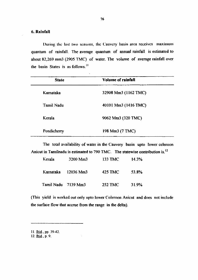
6. Rainfall
Ouiiiig the Inst (wo seasons, the Cauvery basin area receives inaxiinutn
quantum of rainfall. The average quantum of annual rainfall is estimated to
about 82,269 mm3 (2905 TMC) of water. The volume of average rainfall over
the basin States is as follows."
State Volume of rainfall
Kamataka 32908 Mm3 (1162 TMC)
Tamil Nadu 40101 Mm3 (1416 TMC)
Kerala 9062 Mm3 (320 TMC)
Pondicherry 198 Mm3 (7 TMC)
The total availability of water in the Cauvery basin upto lower celeroon
Anicut in Tamilnadu is estimated to 790 TMC. The statewise contribution is.'^
Kerala 3200 Mm3 133 TMC 14.3%
Kamataka 12036 Mm3 425 TMC 53.8%
Tamil Nadu 7139 Mm3 252 TMC 31.9%
(This yield is worked out only upto lower Coleroon Anicut and does not include
the surface flow that accrue from the range in the delta).
11. Ibid., pp. 39-42. 12. Ibid., p. 9.
77
The figures given above indicate that the contribution of Kamataka to
livcM (^auvciy is iiciiily 54"o while I'niniltimlu'H contribiilioii is 3?.%.
Agriculturally, the basin area of Kamataka is dependent only on South-West
monsoon, whereas Tamilnadu is dependent not only on South-West monsoon
but also gets the advantage of North-East Monsoon.
7. Cropping Pattern
The crops that are normally grown in the rainfed Cauvery basin
includes ragi, jowar, sesame, groundnut, red gram and short duration pulses.
However under irrigation area, rice and sugarcane are the main crops. In
Tamilnadu, rice is the major crop and specially after the construction of the
Mettur dam two crop system is cultivated. This two crop system is cultivated in
an area of 30% to 40% of the delta and in the remaining area a long duration single
crop of rice is cultivated. Accordidng to report of the National Commission on
Agriculture (1976) nearly 71% of the irrigated crop area in Tamilnadu is under
nee.
8. Soils
Soil and geological conditions have an important bearing on ground water
availability. The relatively porous soils of the delta facilitate the retention of
moisture and the rechange of the river while hard soils in Kamataka allow water
to run off.
Along the Cauvery basin soil types vary. Generally red soil predominates
in the southern Kamataka plateau and in Coimbatore and Salem districts of
Tamilnadu. While the clay red soil found in Coimbatore is fertile, sandy soil
13. Ibid., pp. 36-38.
78
found in parts of Mysore plateau does not retain moisture well and are unable
to sustain pood crop after the main rainy season. The best soil endowment,
loamy alluvium is found in some parts of Mysore but mainly in the belt along the
river in Tiruchinapalli district and in the Thanjavur delta. In the coastal areas,
soils are less fertile on account of salinity.
III. ORIGIN OF THE CAUVERY WATER DISPUTE
The dispute relating to the sharing of the Cauvey water between
Kamataka and Tamilnadu is a very old dispute. The Cauvery water dispute
differs from other major river water disputes in India, including those relating
to the Narmada, the Krishna and the Godavari. While these disputes were mainly
about tlie inter-state utilisation of hitherto untapped surplus waters, the dispute in
the case of the Cauvery relates to the re-sharing of waters that are aheady being
almost fully utilised in tlieir totality.'"*
The State of Tamilnadu has been using Cauvery waters right from ancient
times. It has been mentioned in "SHABDA MANI DARPANA" - a Kannada
Grammar Book, dating back to 13th century.'^ The Cauvery Water dispute
between Kamataka and Tamilnadu dates back to historical period. Cauvery was a
vexed problem between the Hoysala and Chola Kingdoms. To settle score with
Chokkanath Naik of Madurai Kingdom, Chikkadeva Wodeyar of Mysore
attempted to stop the flow of Cauvery into Tamil region by building a mole
across the river in the 11th century.'*' Historically, Tamilnadu has been
advantageously placed with regard to the creation of irrigation infrastructures.
14. S. Guhan, The Cauvery Water Dispute - Towards Conciliation (Madras, A Frontline Publication, 1993), p. 5.
15. Ramesh Hullukere, Cauvery Jalavivada (in Kannada)., (Mandya, Vikshaka Prakasana, 1991)., p.9.
16. Rcvathi Shiva Kumar, "But Unquiet Flows the Cauvcry", Dcccan Herald, 27 January, 1996
79
while Kamataka unfortunately had no such advantage. The history of irrigation
development in Cauvery basin goes back to 2nd century A.D. when the Grand
Aiiicut is reported to have been constructed across Cauvery by KarikaJa Cliolan.
It has a very large canal system, with 36 distributaries covering a total length of
1600 Kms, 1500 main Channels are fed covering 5600 Kms length and 28000
branches and sub-channels supplying water for irrigating a total length of 19000
Kms. It covered over 14 lakh acres accounting for 47 per cent of river and
canal irrigation of entire Tamilnadu.
Right from the beginning, development of irrigation in Kamataka was
through tanks and Anicuts only. Due to several wars between the Mysore and
Madurai kingdoms, a number of tanks had been destroyed in the Mysore
region. Diwan Poomayya of Mysore ventured to restore these tanks and
initiated a few irrigation works in the Cauvery basin in 1800 A.D, which the
Madras province did not favour."'
For Tamilnadu, tlie major problem in the earlier period was, in fact, not
so much one of supply as of abundance, since the unrestrained flow of the river
made die delta prone to frequent floods. The Grand Anient, which with
subsequent injprovements functions to this day, was the earliest attempt to
control flooding. The other major divisionary and regulatory structure, the Upper
Anicut, planned and constructed by Sir Arthur Cotton in 1836-39, was also for
flood protection.'^ Despite these works, in the period prior to the construction of
17. S. Guhan, The Cauver>' Water Dispute - Towards Conciliation, Op. Cit.. p.2. 18. Revathi Shivakumar, "But Unquiet Flows The Cauvery", Op. Cit. 19. Arthur Cotton (1803-1839) was responsible for the planning and e.xecution of a number of
major irrigation works in South India, notably the upper and Lower Anicuts and the Dowlcshwaram Anicut across the Godavari.
80
the Krishnaraja Sagar reservoir, serious floods were recorded in tlie Cauvery in
1858, 1896, 1906, 1911, 1920 ami 1924.^"
The differences regarding the use of water of the Cauvery between
Mysore and Madras are said to have arisen since 1807, when the then Mysore
State started developing the irrigation projects and the then Madras
Government objected to these developments on the ground that they had acquired
easementary rights and these rights would be affected if the Mysore
Government were allowed to build new irrigation works in the Cauvery basin.
This contention was strongly rejected by the memorandum submitted to
the then Resident of Mysore, by Sir Seshadri Iyer, the tenth Dewan of Mysore.
He pleaded that it was "collect and store casual and intermittent supply of rain
water which falls upon the Mysore lands." He further stated that one of the
fundamental rules of the general principles of law is that a state has a greater
right of control over water falling on the surface of its own lands and entering
into a defined chamiel than it would in a case of streams rising outside its
frontier and merely flowing through it.^' In fact, even Colonel Sankeys, in his
letter favoured Mysore where he viewed Mysore's developments as nothing but
a new method of securing what tlie old system secured in a different way (old
tank system).
But during (his period, Madras was a British Province directly
governed by Paramountcy. Mysore was a Princely State. Obviously Madras was
20. S. Guhan, The Cauvery Water Dispute Towards Conciliation, Op. Cit., p. 7. Also read K.S. Muncgowda, "Ilic Cauvcry Water Dispute", in V.K. Natraj, M.N. Sastry Ed., New Perspectives In Centre State Relations In India (Mysore, Prasaranga, University of Mysore, 1975). pp. 281-304.
21. M. Basheer Hussain. The Cauvery Water Dispute (Mysore, Rao and Raghavan, 1972), pp. 1-2. 22. Ibid, p. 4.
81
enjoying a more powerful political status. The relationship between the two
was similar to that of a sovereign power and a feudal unit. Because of these
reasons, the then British Govermnent favoured Madras. In 1890, the
representatives of both Mysore and Madras met in a conference to sort out the
differences. Due to a number of conditions posed by Madras which adversely
affected tlie development of irrigation in Mysore, the Conference failed to
arrive at a conclusion satisfactory to both parties.
Thereafter, Mysore represented to the Government of India for redress.
At the instance of tlie Government of India further discussion took place
between the two Governments, which ultimately led to the General Agreement
of 1892.
IV. INTER-STATE AGREEMENTS OF 1892 AND 1924 ON CAUVERV
RIVER WATER
A. BACKGROUND TO THE AGREEMENT OF 1892
As early as 1807, there was correspondence between Madras and
Mysore on the latter's use of waters in the Cauvery and in its tributaries. 1 his
was the period (1800-1810) when a number of minor irrigation works were
initiated in Mysore. During 1831-1881, when the Mysore administration was
taken over by the British, schemes for irrigation development continued and a
Public Works Department was established in 1856.
In 1866, Col. R.J. Sankey prepared a plan for the restoration,
extension and improvement of irrigation works in Mysore, to fully use the
23. H.M. Channabasapa, Water Rights And Cauverv Dispute (Bangalore: Government of Kamataka, 1975), pp. 14-15.
82
rainful over the Mysore Plateau and to secure the whole of the territory against
drought and famine. This plan was approved by the Government of India and
the Secretary of State in 1872. A separate department of irrigation was created to
implement the plan. However financial stringency and the famine that followed
in 1877-78 prevented the plan from being carried forward. The plan was
revived again witli tlie restoration of tlie Maharaja's administration in 1881.
The steady investment and regulating work undertaken by Mysore
raised apprehensions in Madras about the possible implications to it, as a
lower riparian. In 1870, the Madras Government voiced its concern with the
Mysore Government. In the years that followed there was inconclusive
exchange of correspondence and the Mysore Government signed an Agreement
witli the Madras Government in 1892, inspite of the plea of the then Dewan of
Mysore Sri Seshadri Iyer.
1892 AGREEMENT
The Agreement is entitled, "Rules defining the limits within which no
new irrigation works are to be constructed by Mysore State without previous
reference to Madras Government." This Agreement consists of only six rules.^''
The title itself indicates that this Agreement imposes restrictions on
Mysore without any corresponding obligations on Madras. Apart fi"om imposing
severe restrictions on Mysore on the utilisation of waters of river Cauvery and
its tributaries for development of irrigation, the 1892 Agreement made it
practically obligatory for Mysore to obtain prior consent of the then Madras
Presidency before taking up any irrigation works. No corresponding restrictions
24. For a fiill text of the 1892 Agreement, see Appendix HI. Only the relevant portions of the 1892 Agreement are recalled here.
83
were imposed on Madras. The terms of Agreement gave the lower ripanion
states a veto power over all the irrigation works of an upper riparian state
whether or not it suffered any damage.
Rule II of the Agreement provides, that the Mysore Government shall
not without previous consent of Madras Government, construct any new reservoir
in schedule 'A'. Schedule B'̂ ^ is a long list of streams specifying points below
which no irrigation works are to be imdertaken by Mysore.
Rule III states that, when the Mysore Government desires to construct
any "New Irrigation Reservoir" or any new Anicut requiring the previous
consent of the Madras Government under the last preceding rule, the full
information regarding the proposed work shall be forwarded to the Madras
Government and the consent of the Government shall be obtained previous to
the actual commencement of work. The Madras Government shall be found not
to refuse such consent except for the protection of prescriptive right already
acquired and actually existing, the existence, extent and nature of such right
and the mode of exercising it being in every case determined in accordance with
the law on the subject of prescriptive right to use of water and in accordance
with what is fair and reasonable under all the circumstances of each.
Rule IV envisages that, whenever there arises a difference of opinion
between Madras and Mysore Government in any case in which the consent of the
former is applied for.... the same shall be referred to the final decision either
to iiibitiniois, appoiiilcd by both (lovciiiinciils or uf'lhc (jovcniiiicnt oriiulin.
25. Schedule "A" refers to Cauvery, Hemavathi, Lakshmanathirtha, Kabini, Suvamavathi or HonnuhoUa, Yagachi (upto Belur bridge). Schedule "B" refers to a test of minor streams and Catchments in Mysore territory on which no new irrigation reservoir are to be built within the unit specified without previous reference to Madras Government.
84
The reason for Mysore accepting the unequal, one sided Agreement of
1892 could be found in the Constitutional position which Mysore was occupying
under the then British Government. It was being controlled by a British
Resident. He was the real ruler of the State. As Panikar rightly writes, "all
those who have direct experience of Indian States know that the whisper of the
regency is tlie tliunder of tlie States and there is no matter on which the Resident
does not feel qualified to give advice. His advice was usually an order or a
command. "̂ ^ At the same time, Madras Presidency was administered by a
Governor. His position in the pohtical set up of the country in those days was
only next to the Governor General. When compared to a Governor the status of a
Resident was quite inferior. Even the Dewans in those days were appointed with
the approval of Government of India.
In course of time both Mysore and Madras realised that the 1892
Agreement was against their interests. Mysore felt that irrigation development in
its territory was subjected to undefined Prescriptive Right of Madras. While
Madras felt that it had been deprived of any share in available surpluses over and
above its Prescriptive Right which might remain un-utilised for a long time and
thereby form part of its entitiement under the common law of natural flow. The
1892 Agreement thus left much scope for conflict.
B. CIRCUMSTANCES LEADING TO 1924 AGREEMENT
After signing the 1892 Agreement, no signiiicant irrigation development
took place in the Mysore State. It was in 1900, that Mysore mooted the first
proposal under the 1892 Agreement to set up a hydroelectric station at
Sivasamudram to supply power to the Kolar Gold Fields. Since it was a
run-of-the-river scheme tliat did not involve any irrigation or interception of
26. M. Basheer Hussain, The Cauvery Water Dispute, Op. Cit.. pp.6
85
water, Madras gave its concurrence. In 1910 Mysore prepared plans for the
construction of the Kannambadi dam below the Raraaswamy Anient on the
Cauvery and about 13 Kms upstream of Srirangapatna. The dam was proposed
to be built in two stages. The first stage would consist of the building of a dam
80 feet high to store 11 TMC ft water, to ensure continuous supply to the
Sivasamudram Hydro-electric Station which was the first of its kind in Asia.
While the second stage would raise the capacity to 41.5 TMC ft. Besides being
a back-up reservior to ensure steady power supplies to the Kolar Gold Fields, the
dam was also intended for irrigation. The chief architect of this prestigious
project was engineer-visionary Sir. M. Visveswarayya.^'
On the Madras side, investigations had begun in 1856 itself on sites and
schemes for a reservoir on the Cauvery to contain floods, ensure better
regulation in the delta, and extend irrigation. In 1906 a proposal was
formulated under which irrigation was to be provided by channels taking off at
Kattalai above the Upper Anient. Later in 1910, a Canal fi-om Grand Anient to
irrigate the dry taluks of Soutliem Thanjavur was decided. This was tlie
genesis of the Cauvery - Mettur Project (the Krishnarajasagar (KRS) dam,
being the Mysore Cauvery project).^*
Proposals for both the Mysore and the Madras Projects were formulated
simultaneously at the end of 1910. This was followed by the correspondence
between the two Governments on the one hand and between each one of them and
tlie Govermnent of India (GOl) on the otlier. Mysore urged the iimnediate
clearance of the first stage of the Kannambadi Project retaining the option to
27. K.S. Munnegowda, "The Cauvery Water Dispute", in V.K. Natraj, M.N. Sastry, Ed, New Perspectives in Centre-State Relations in India, Op. Cit.. p. 283.
28. For histories of the Cauvery - Mettur Project, See C.G.Barber History of Cauvery-Mettur Project (Madras, Government of Madras, 1940) and S.Y. Krishnaswamy, Rural Problems in Madras Presidency (Madras, Government of Madras, 1947).
86
take up tlie second stage at a later stage. While consenting to the first stage
of tlie Kannambadi project, Madras objected to tlie second stage of construction
on tfie plea that it would affect the existing irrigation in tlie Cauvery delta. Madras
also urged the Government of India to delink the Government of India's clearance
for the Madras Project, fi-om Madras concurrence with the Mysore Project.^'
The Government of India was not willing to delink the two proposals and
prefetTcd the differences between Mysore and Madras to be settled bilaterally.
This was found to be not possible during the exchanges since 1910 onwards.
Thereupon in 1913, the Government of India appointed a Court of Arbitration
presided over by Sir.Henry Griffin, judge of the Allahabad High Court. He was
assisted by Nethersole, Inspector General of Irrigation in India. The Award of
the Court known as the "Griffin Award" was given in 1914. It interpreted the
1892 Agreement to entitle Madras to such right as it had acquired by
prescription and as were fair and reasonable, and held that a 20 year period
was requisite to earn a title by prescription. It found that the construction and
working of the proposed Kannambadi reservoir to its full height (124 ft) and
capacity (41.5 TMC) would not necessarily interfere with the prescriptive
rights of Madras. Specifically, the Griffin Award fixed the requirements of
Madras for its existing irrigation at 22,750 cusecs equivalent to a gauge reading
of 6.5 ft at the Upper Anient. The arbitrator held that the scheme of regulation
could be reviewed, revised and readjusted by mutual agreement.^"
The "Griffin Award" was not accepted by the Madras Government
which went on representation against it to the Government of India (GOI) in 1915.
The representation stated that Madras should be assured of a higher inflow at the
29. H.M. Channabasappa, Water Rights And Cauvery Dispute, Op. Cit.. pp. 16-17. 30. The Cauvery Arbitration Award. 1914 (Mysore Representative Assembly Proceedings), p. 27.
87
Upper Anicut (26,750 cusecs and 7 ft on the gauge instead of 22,750 cusecs and
6.5 ft allowed in the Award). It also stated that the system of regulation,
which under the Award was diflerent from that proposed by either party, should
be modified to one acceptable to both and that tlie Award afforded inadequate
protection to Madras in respect of surplus waters of the river and of future
extensions of irrigation.
It may be noted that at tiie time of the pronouncement of the Griffin
Award, die totd area irrigated in die Cauvery valley of the Mysore territory was
115,000 acres but the corresponding area in the lower reaches of the river within
the Madras State was 225, 500 acres. Further a large surplus flow into the river
goes to waste into the sea year after year, after meeting the needs of both Madras
and Mysore irrigation. The Mysore project was, intended to share only a small
portion of this surplus. Madras wanted not only the continuous flow of enough
water to meet its existing demand, but sufficient enough to fill a fiiture reservoir at
Mettur and to use it to extend irrigation to 300,000 acres of new area in the
Cauvery basin.''
The Government of India did not accept the contentions of Madras and
in 1916 conveyed its decision to ratify the Award without modification. The
Madras Government went on appeal to the Secretary of State against this
decision. In 1919, after consulting independent expert opinion, the Secretary of
State decided on procedural and substantive grounds, that there was a prima facie
case for not ratifying the Award, thereby upholding the appeal of Madras.
The Secretary of State then gave the Mysore Government one of three options
including (i) to appeal against the Secretary of State's decision, (ii) to enter
fresh arbitration or (iii) to arrive at a negotiated settlement with Madras.^^
31. M. Visveswaray>a, Memoirs Of My Working Life (Bombay. Caxton Press, 1951), p. 46. 32. Mysore State Gazetteer. Mandya District (Bangalore, Goyemment Press, 1967), p. 113.
88
The political status of native state was not one of real autonomy even in
inlcnial matters. Ihe extent of iiilerfereiice by the Secretary of State with
affairs of native states wasregulatednot by law but by considerations of policy.
Moreover, the economic development of native states was not the
responsibility of the British Government. Caught up in this situation, Mysore
choose tlie third mettiod as it wanted an early solution so that it could complete
the Krishnarajasagar dam.
hi tliis context, negotiations were initiated in 1920 at the level of Chief
Engineers of both States.'^ After several meetings between the Engineers, the
draft rules of regulations for KRS were finalised in July 1921. The rules were
based on month-wise varying liinit gauges at the Upper Anient during the
irrigation season of June to January, to reflect variations in the monsoon flows in
the river and the corresponding discharges (called limit flows) required at KRS to
maintain tliem. Ihese parameters, wliich were tabled in the draft were derived
from joint gauge readings during 1917-20 and were subject to final revision
after ten years i.e., in 1926. Any excess of the forecast flow at the Upper
Anient over the limit flow could be impounded by Mysore, with the forecast
flow at the Upper Anient to be estimated by applying a seasonally varying
proportion factor to the flow into KRS.
The significance of the 1921 draft rules was that they, for the first time
gave operational content to the "Prescriptive Right" of Madras. This was done
in terms of the formula for impounding flows at KRS only after liinit flows at
the Upper Anient were ensured. However, it must be noted that the regimen
of the rules did not guarantee any minimum or assured quantity of water at the
Upper Anicut. The limit flows at KRS assumed only that the natural flow upto
33. The Chief Engineers who took part in the 1920 negotiations were S. Cadambi, Chief Engineer, Mysore and W.J.J. Howley, Chief Engineer, Madras. They were assisted by J.R.J.Ward, Inspector General of Irrigation, Government of India.
89
the limit would be available to Madras and that only flows above this threshold
could be impounded by Mysore. On a day-to-day basis when natural flows
happened to be below the limit, Madras had to be content with a lesser quantity,
on days when they were above the limit, the surpluses could be fully unpounded
and retained by Mysore and need not be drawn down to make good the deficit in
subsequent days of naturally deficit flows.^
The draft rules were not acceptable to Mysore. The main objections
tliat were raised related to two clauses. Firstly, the proposed rules of regulation
were to prevail over the 1892 Agreement in the event of conflict betweem the
two. The second stated that nothing in the proposed rules should be construed as
in any way restricting the grounds on which the Government of Madras might
claim to withhold consent to the construction of any new irrigation reservoir or
any new Anient. Madras on the other hand was not content with the "Prescriptive
Riglit" being assured. It wanted a share on "Equitable Basis" of all the surpluses
of the Cauvery basin.
These differences led to exchange of correspondence, meetings and
conferences between the Dewan of Mysore A.R. Banerji and successive
Members of the Governor's Council in Madras: K, Srinivasa Ayyangar,
Charles Todhunter and C.P.Ramaswamy Iyer, between 1921 to early 1924.̂ ^
After deliberations, Mysore was forced to enter into an Agreement on 18th
February 1924. On this Agreement Sir M. Visveswarayya remarked that, "this
Agreement was between two unequals - a suzarain power on the one side and a
feudal unit on the other in which the weaker section has no alternative but to
yield."''
34. S. Guhan, The Cauvery River Dispute - Towards Conciliation, Op. Cit.. pp. 12-13. 35. Ibid, pp. 13-14. 36. M.P. Nagendra Murthy, "Inter-State Water Dispute With Reference To Cauvery",
Unpublished Master's Degree Dissertation in Law (Mysore, University of Mysore, 1992), p.89.
90
C. THE 1924 AGREEMENT
Tliis Agreement was tlie off-shoot of 1892 Agreement and an outcome of
continued negotiations over a period of 14 years. The Agreement consists of 10
ciauses.^^ The first nine clauses includes the events starting with the 1892
Agreement. This Agreement focusses attention on the KRS reservoir and
includes rules and regulations accepted by the Chief Engineers of the two sides
in July 1921. The rules became part of the Agreement. The right of the Madras
Govenmient to extend irrigation work on the tributaries of the Cauvery was
preserved. The interesting aspect of this Agreement is that it took mto
consideration the effect of the interests and rights of the French Territory also.
Elaborate rules and regulations of KRS reservoir, which was then under
construction have been set out as an annexure to the 1924 Agreement. This
covers aspects such as guage readings, impoudnig formula, inflow
computations, allowances for irrigation extension in Mysore, hot weather flow
from KRS, rate of evaporation, regulation of sluices, daily reporting of
register, entries and inspection of records.^*
The main clauses among the 15 operative clauses of the Agreement
are as follows:
1. Mysore Government may construct KRS reservoir to a height of 124 ft above
the river bed and to an effective capacity of 44.827 TMC ft to irrigate 1.25
lakh acres.
2. Mysore Government agrees to regulate discharges through and from KRS
reservoir strictly in accordance with the rules and regulations which forms part
of this Agreement.
37. For a fall text of the 1924 Mrecment see Appendix IV. Only the relevant portions of the 1924 Agreement are discussed here.
38. Financial Express.. 9 August 1991.
91
3. Madras Government is permitted to construct a reservoir at Mettm" to an
efective capacity of 93.5 TMC ft to extend irrigation by 3.01 lakh acres in
the delta area.
4. There should be mutual exchange of returns of technical details and
extension of irrigation at the close of each official year.
5. Mysore Government may make further extension of irrigation to the tune of
1,10,000 acres by constructing reservoirs of aggregate capacity of 45 TMC
ft on the Cauvery and its tributaries without infiinging the accepted rules
and regulations of discharges at KRS.
6. Mysore Government is also permitted to extend irrigation by improvement of
duty under each one of the irrigation channels to the extent of 1/3 of what
was being irrigated prior to 1910.
7. Mysore should furnish all particulars of reservoirs it proposes to build
against the permissible limit of 45 TMC ft to Madras Government.
8. Madras Government may construct new irrigation reservoirs on the tributaries
like Bhavani, Amaravati, and Noyil rivers. If they do so, Mysore may
construct an off set reservoir of capacity not exceeding 60% of the new
reservoir constructed by Madras. The impounding should not however
diminish the supplies to which Madras and Mysore are entitled under this
Agreement including die divisible surplus.
9. Both Governments agree that the limitations and arrangements embodied in
Clause IV and V i.e., in respect of extension of irrigation by both
Governments set out shall after the expiry of 50 years (in 1974) be opened
to reconsideration in the liglit of the experience, gained and for an
92
examination of the possibilities of further extension of irrigation within the
lerritories of the respccfive Govenimenis and to such modifications and
additions as may be mutually agreed upon as a result of such reconsideration.
10. In case of a dispute between the two Governments touching the interpretation
or operation or carrying out this Agreement, such a dispute shall be referred
to arbitration or to Government oflndiaifboth parties agree for settlement.
Thus the 1924 Agreement was in the nature of follow up action on the
original 1892 Agreement, the validity of which continued to survive. In short,
Madras gave its assent under Clause 3 of the 1892 Agreement to Mysore to
construct KRS reservoir and secured the right to construct its Mettur Project and
both Madras and Mysore obtained additional right to extend irrigation to new 39
areas.
The 1924 Agreement shows that the Madras Government at that time was
more powerful than the Mysore Government. F.J.Berber writes that, "Ffie
Cauvery Dispute between Princely Mysore and Madras Presidency, settled in 1924
was a dispute between British India and the other was a dependent Princely State
under the British suzerainty. 1 he dispute was not settled by the application of
law, but through the authoritative decision of the sovereign power or the British
crown."""
V. IRRIGATION DEVELOPMENT IN POST 1924
In Mysore, irrigation from major and medium works under the Cauvery
which was 1.1 lakh acres at the beginning of the century increased to 3 lakh
39. N.D. Gulhati, Development Of Inter-State Rivers: Law And Practice In India (New Delhi, Allied Publishers, 1972), p. 113.
40. F.J. Berber, Rivers In International Law (London, Stevens and Sons, 1959), pp. 180-181.
93
acres by 1930 with the extension of irrigation under the KRS. By 1970, it had
further risen to about 4.4 lakh acres. About half of this increment of 1.4 lakh
acres was contributed by new irrigation from small reservoirs, Anicuts and
channels on the tributaries, and the other half by extension of irrigation under the
KRS Anient and Channels.'"
As a result of Post-Independence recognition of political units some
Princely States got merged with the neighbouring states and through the States
Re-organisation Act, 1956 the boundaries of certain states were also
changed. Thus the erstwhile Princely State of Travancore became part of Kerala
and Mysore became Kamataka and after bifurcation of Madras, Tamilnadu
became the successor of Madras in regard to Cauvery matter.
In Tamilnadu, ayacut development in this period was more fast and
significant. The initial pre-Mettur extent of 14.4 lakh acres of irrigation was
augmented by Mettur to an extent of 3.2 lakh acres and to an equal extent by
projects implemented in the first plan (1951-56) and Second Plan (1956-61)
periods. The first plan projects were the Lower Bhavani Project (covering 2.1
lakh acres) and the Mettur Canal Project (0.5 lakh acres). The three Second Plan
projects, the Amaravathy, the New Kattalai High Level Canal and the
Pullambadi Canal were to add about 0.2 lakh acres each. Mysore objected these
new projects on the ground that they were not permissible under the 1924
Agreement. Madras maintained that irrigation from the Mettur Canal was within
the acreage limit allowed for the Cauvery-Mettur project. The other two projects
were cleared by the Planning Commission on the assurance of the Madras
41. Achutha Menon, The Hindu. 23 April 1970 and 15 May 1970.
94
Government that these projects would utilise only surplus waters or waters saved
by economy and would not entail the creation of any new prescriptive rights.
Overall, the Mettur and other 1934-72 projects added 6.4 lakh acres to
the pre-Mettur extent of 14.4 lakh acres. In addition, the area under a second
crop was increased to a total extent of 4.5 lakh acres of this, 2.5 lakh acres was
located in the old Cauvery delta, 0.8 lakh acres in the Coleroon system, 0.8 lakh
acres under the canals in Salem and Tiruchinapalli districts and 0.4 lakh acres in
the Bhavani and the Amaravathy sub-basins. Madras did not seek any extra waters
on account of extensions to irrigation beyond what had been assured to it under
the 1924 rules of regulation.'*^
The Kamataka Government under its development plans took up
constructional work on some irrigation projects to utilise its share of water
under the 1924 Agreement. Work on the Kabini reservoir was commenced in
1959, although the project had been discussed in 1933 itself.
Later projects began with dams and reservoirs on tributaries including the
Harangi (1964), Swamavathy (1965), the Hemavathy (1968), the Varuna Canal
(extension from KRS, 1979) and the Yagachi (1983). The total irrigation
potential under these schemes upto 1990 was expected to be about 13 lakh
acres with actual established irrigation until then being 11.2 lakh acres.
The contention of Tamilnadu is that the projects undertaken by Kamataka
aie not within tlie stipulated limits and were ui excess of tlie allowances made
in the 1924 Agreement for newirigation m Kamataka. It also opined that the
42. S.C. Jain, Alice Jacob, Subhas C. Jain. "Inter-State Water Disputes In India", Indian Law Institute Journal. 1971, p. 48
43. S.Gnhan, The Cauvcry River Dispute - Towards Conciliation Op. Cit.. pp. 18-19.
95
new projects under taken by Kamataka would reduce the assured supplies to
Tamilnadu through limit flows from KRS and that the 1924 Agreement covers
storages in non-scheduled rivers only if they do not affect Tamilnadu's
prescriptive right.'*'*
Owing to laiiiilnadu's objections, the above projects were not cleared by
the Central Water Commission or by the Union Planning Conmiission for
inclusion under Plan Schemes in Kamataka. Expenses on them have been
met from non-Plan allocations and Kamataka argues diat this has resulted in
loss of Central assistance, improper funding and execution delays. Along with
requirements of 85.2 TMC ft for minor irrigation, 50 TMC ft for water supply
and 7 TMC ft for power peojects, Kamataka has projected its requirements at
465 TMC ft.
The development of major and minor irrigation in Kamataka upto 1990 is
as follows:
44. Loc. Cit.
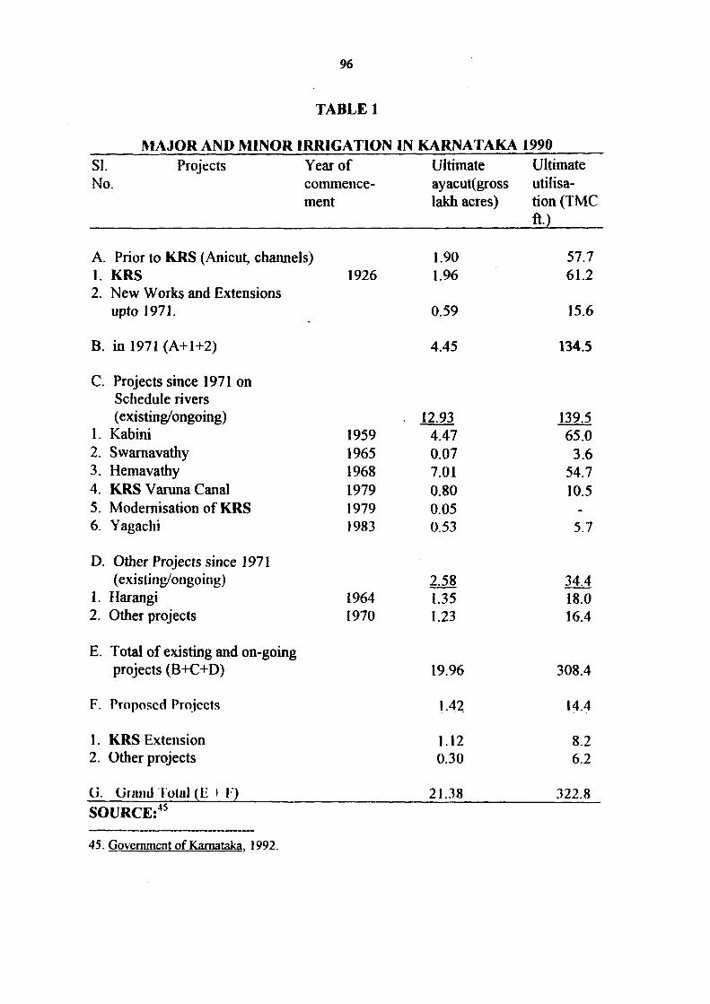
96
TABLE 1
SI. No.
MAJOR AND MINOR IRRIGATION IN KARNATAKA 1990 Projects Year of Ultimate
commence- ayacut(gross ment lakh acres)
Ultimate utilisation (IMC ft.)
A. Prior to KRS (Anicut, chaimels) 1. KRS 2. New Works and Extensions
upto 1971.
B. in 1971 (A+1+2)
C. Projects since 1971 on Schedule rivers (existing/ongoing)
1. Kabini 2. Swamavathy 3. Hemavathy 4. KRS Varuna Canal 5. Modernisation of KRS 6. Yagachi
D. Other Projects since 1971 (existing/ongoing)
1. Harangi 2. Other projects
E. Total of existing and on-going projects (B+C+D)
F. Proposed Projects
1. KRS Extension 2. Otlier projects
G. Grand 1 olal (11 i 1)
1926
1959 1965 1968 1979 1979 1983
1964 1970
1.90 1.96
0.59
4.45
12.93 4.47 0.07 7.01 0.80 0.05 0.53
2.58 1.35 1.23
19.96
1 42
1.12 0.30
21.38
57.7 61.2
15.6
134.5
139.5 65.0
3.6 54.7 10.5
-
5.7
34.4 18.0 16.4
308.4
14.4
8.2 6.2
322.8 SOURCE:̂ ^
45. Government of Kamataka. 1992.
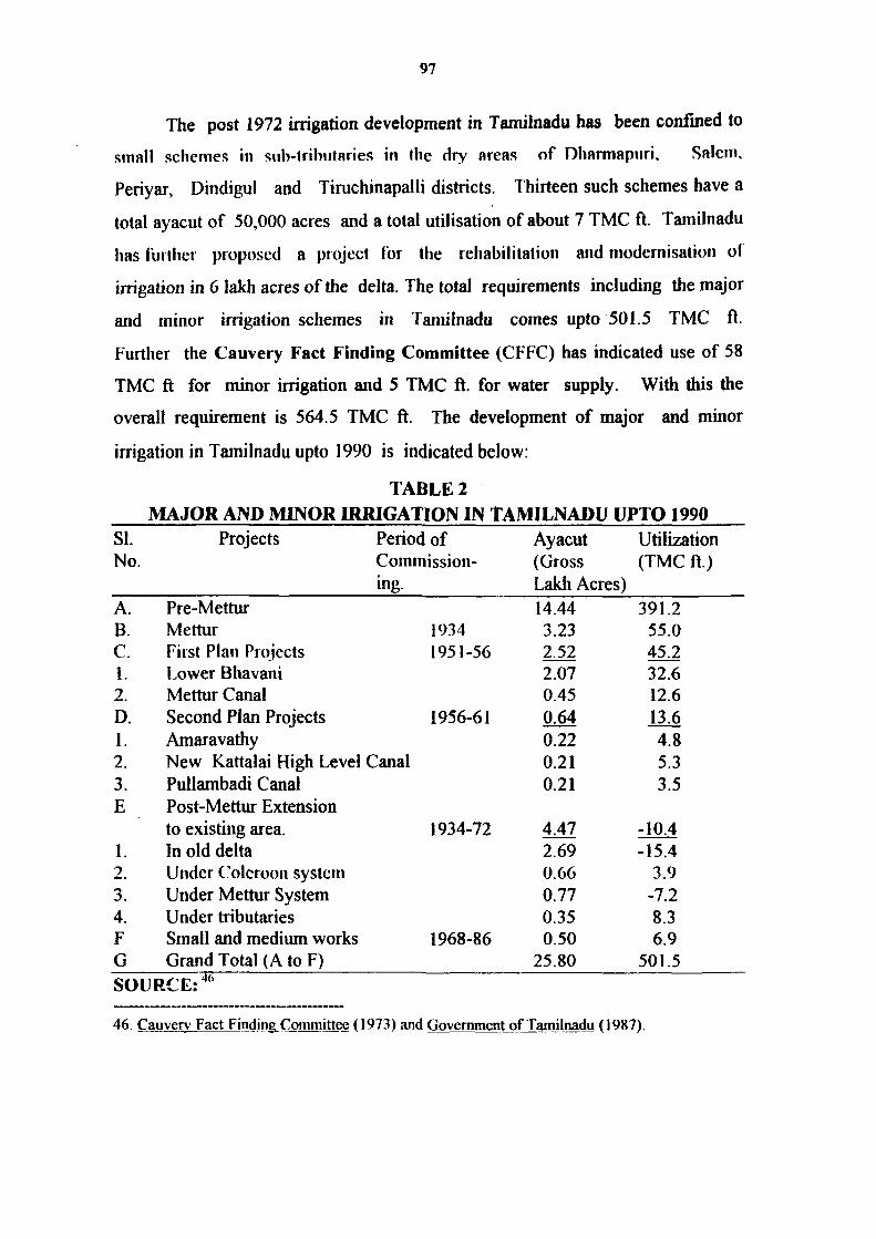
97
The post 1972 irrigation development in Tamilnadu has been confined to
small schemes in siib-tTibiitaiies in the dry areas of Dharmapnri, Salem,
Periyar, Dindigul and Tiruchinapalli districts. Thirteen such schemes have a
total ayacut of 50,000 acres and a total utilisation of about 7 TMC ft. Tamilnadu
has further proposed a project for the rehabilitation and modernisation ol
irrigation in 6 lakh acres of the delta. The total requirements including the major
and minor irrigation schemes in Tamiinadu comes upto 501.5 TMC ft.
Further the Cauvery Fact Finding Committee (CFFC) has indicated use of 58
TMC ft for minor irrigation and 5 TMC ft. for water supply. With this the
overall requkement is 564.5 TMC ft. The development of major and minor
irrigation in Tainilnadu upto 1990 is indicated below:
TABLE 2 MAJOR AND MINOR IRRIGATION IN TAMILNADU UPTO 1990
SI. Projects No.
A. Pre-Mettur B. Mettur C. First Plan Projects 1. Lower Bhavani 2. Mettur Canal D. Second Plan Projects 1. Amaravathy
Period of Commissioning.
2. New Kattalai High Level Canal 3. PuUambadi Canal E Post-Mettur Extension
to existing area. 1. In old delta 2. Under Colcroon system 3. Under Mettur System 4. Under tributaries F Small and medium works G Grand Total (A to F) SOURCE:'"
1934 1951-56
1956-61
1934-72
1968-86
Ayacut (Gross Lakli Acres) 14.44 3.23 2.52 2.07 0.45 0.64 0.22 0.21 0.21
4.47 2.69 0.66 0.77 0.35 0.50
25.80
Utilization (TMC ft.)
391.2 55.0 45.2 32.6 12.6 13.6 4.8 5.3 3.5
-10.4 -15.4
3.9 -7.2 8.3 6.9
501.5
46. Cauver\' Fact Finding Committee (1973) and Government of Tamilnadu (1987).

98
The table given below illustrates the Cauvery irrigation development in
Kamataka and Tamihiadu from 1901 to 1990.
TABLE 3
CAUVERY IRRIGATION DEVELOPMENT IN KARNATAKA AND TAMILNADU FROM 1901 TO 1990
State
KARNATAKA 1901 1928 1971
1990 and beyond (estimated)
TAMIL NADU 1901 1928 1971 1990
Area (Gross Lakh Acres)
1.11 1.11 4.42
21.38
13.45 14.44 25.30 25.80
Estimated Utilisation Requirement for Utilisation (IMC ft.)
27.2 27.2
110.2
322.8
366.9 391.2 494.6 501.5
SOURCE:''^
There has been growth in terms of area and utilisation in Kamataka since
1970s. Consequently, it has resulted in a decline of availabilities for actual
utilisation in Tamil Nadu in this period, with the fall in the inflow and Mettur in
post 1970s and specially in 1980s. The share of Kamataka in utilisation in the
yield above Mettur has increased during this period. The Table given below
illustrates this:
47. Goveninient of Kamataka (1990) and Government of Tamilnadu (1990)
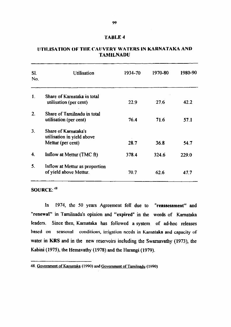
99
TABLE 4
UTILISATION OF THE CAUVERY WATERS IN KARNATAKA AND TAMILNADU
SI. No.
Utilisation 1934-70 1970-80 1980-90
1. Share of Kamataka in total utilisation (per cent)
2. Share of Tamilnadu in total utilisation (per cent)
3. Share of Kamataka's utilisation in yield above Mettur (per cent)
4. Inflow at Mettur (TMC ft)
5. Inflow at Mettur as proportion of yield above Mettur.
22.9
76.4
28.7
378.4
70.7
27.6
71.6
36.8
324.6
62.6
42.2
57.1
54.7
229.0
47.7
SOURCE: 'IS
In 1974, the 50 years Agreement fell due to "reassessment" and
"renewal" in Tamibiadu's opinion and "expired" in flie words of Kamataka
leaders. Since then, Kamataka has followed a system of ad-hoc releases
based on scasuiial cotiditiuiis, itTJgatiuii needs in Karnataka and capacity uf
water in KRS and in the new reservoirs including the Swaraavathy (1973), the
Kabini (1975), the Hemavathy (1978) and the Harangi (1979).
48. Government of Kamataka (1990) and Government of Tamilnarfn (1990)
100
Responding to Tamilnadu's plea, Kamataka made supplemental releases
in some years, towards the end of irrigation season/' In return for such releases,
Kamataka has demanded supply of power from Tamilnadu at concessional rates
equivalent to the quantity of water released. As a result, since 1974 inflows at
Mettur have ceased to be predictable or assumed. Developments like these, have
aggravated the Cauvery Water dispute between Kamataka and Tamilnadu.
Since late 1960's the two States have engaged themselves in negotiations to find
an amicable solution to the problem.
49. Such ad-hoc releases have been (in TMC ft) 60 in 1976-77, 25.4 in 1982-83, 5 in 1983-84, 17.1 in 1985-86, 11.4 in 1986-87, 4 in 1987-88, 10 in 1988-89 and 5 in 1990. Cited in S.Guhan, The Cauvery Water Dispute - Towards Conciliation, Op. Cit.. p. 24.