Embed Size (px)
Citation preview

24 Regional Bushfire Planning Assessment | HUME REGION
Mansfield Shire is located in the south of the region and has a land area of about 3900 square kilometres. The main township is Mansfield, with a population of 3000 located approximately 180 kilometres north-east of Melbourne and 65 kilometres south of Benalla. The population for the entire municipality is approximately 7972.
The population has continued to increase incrementally in recent years. This is partly attributed to the municipality being part of the ‘tree change’ trend, including a tendency for absentee landowners to become permanent residents when they retire.
The shire is characterised by its cleared grazing country, valleys, foothills and mountains which extend from the western side of the Great Dividing Range. Parts of the Alpine National Park (including Mt Buller and Mt Stirling) fall in the Shire’s boundaries, along with part of the Lake Eildon National Park. There are a number of small settlements throughout the Shire however these settlements have relatively small permanent populations.
Due to the modification of the landscape for grazing, areas of significant biodiversity are primarily limited to the undulating landscapes adjacent to the Alpine and Lake Eildon National Parks, along watercourses and in some areas of scattered vegetation. The clearance of native vegetation is managed through the Environmental Significance and Significant Landscape Overlays which apply to water supply catchments, remnant vegetation patches and significant vegetated landscapes.
Areas where development pressure is being experienced are near forested land and often in locations where there is only one access road.
7.1 Northern area
The northern area of the municipality is where the majority of settlements are located. Settlements adjacent to the Alpine National Park in the north interface with bushfire hazard areas. In addition to these existing settlements, there is development pressure in a number of areas in the region, including land adjacent to the Lake Eildon foreshore and pockets adjoining the Alpine National Park in the east.
Vegetated areas extend from the national park towards the agricultural landscape in the centre of the municipality’s northern area. While some areas are devoid of significant vegetation, there are pockets of vegetation mapped as being high or very high conservation significance scattered throughout the landscape, mainly to the north and north-east.
7.2 Southern area
The southern area of the municipality is predominantly public land, including the Alpine National Park. However, some settlements exist along Mansfield-Woods Point Road which follows a narrow valley between Jamieson and Woods Point. The existing settlements interact with bushfire hazard areas of dense vegetation considered to be of high or very high conservation significance. This valley contains single access road arrangements.
7.0 MUNICIPAL OVERVIEW – MANSFIELD SHIRE

Regional Bushfire Planning Assessment | HUME REGION 25
MANSFIELD MUNICIPAL MAP – MAP 1
N

26 Regional Bushfire Planning Assessment | HUME REGION
MANSFIELD MUNICIPAL MAP – MAP 2
N

Regional Bushfire Planning Assessment | HUME REGION 27
MANSFIELD MUNICIPAL MAP – MAP 3
N

28 Regional Bushfire Planning Assessment | HUME REGION
MANSFIELD – IDENTIFIED AREA DESCRIPTION TABLE
IDENTIFIED AREA CODE LOCATION IDENTIFIED AREA DESCRIPTION
82-001 Tolmie Cluster of rural-residential lots along Bunston Road are in proximity to a bushfire hazard area associated with remnant vegetation and plantation.
82-002 Mount Buller Cluster of resort chalets at Mount Buller in bushfire hazard areas associated with the surrounding Alpine National Park.
82-003 Sawmill Settlement Residential lots in and to the south of Sawmill Settlement, including some undeveloped, are in the bushfire hazard area associated with the surrounding Alpine National Park.
82-004 Bonnie Doon Development pressure is being experienced to the north and south of Bonnie Doon, including stretching along Lake Eildon towards a bushfire hazard area associated with scattered remnant vegetation and pine plantations.
82-005 Howes Creek / Goughs Bay Development pressure is being experienced in Howes Creek and Goughs Bay, between Howes Creek and Lake Eildon, towards a bushfire hazard area associated with scattered remnant vegetation and plantations. There is already a substantial number of dwellings on larger rural-residential lots in this locality.
82-006 Tolmie Plantations in the area surrounding Tolmie, are a known bushfire hazard.
82-007 Macs Cove to Goughs Bay Development pressure is being experienced (including in the Special Use Zone, residential golf estate) between Macs Cove and Goughs Bay towards a bushfire hazard area associated with remnant vegetation.
82-008 Howqua Inlet Cluster of residential lots at Howqua Inlet, in a bushfire hazard area associated with surrounding remnant vegetation.
82-009 Sawmill settlement All boundaries of Sawmill Settlement interface with bushfire hazard associated with the Alpine National Park.
82-010 Jamison / Kevington Clusters of rural-residential lots along Mansfield-Woods Point Road are in the bushfire hazard area associated with the surrounding Lake Eildon National Park and Alpine National Park.
Existing vegetation includes areas of high and very high conservation significance.
82-011 Mount Buller Mount Buller resort chalets rely on Mount Buller Tourist Road for access and egress from the Alpine National Park. Single constructed road extending east and west along Mount Buller Tourist Road.
82-012 Merrijig Cluster of small lots in Merrijig along the Mount Buller Tourist Drive in a bushfire hazard area containing remnant vegetation interfacing with the Alpine National Park to the south, north and east.
82-013 Woods Point Township of Woods Point interfaces with bushfire hazard associated with surrounding national park.
82-014 Enochs Point Big River Road, a single dirt access road, services the cluster of rural-residential dwellings at Enochs Point.
82-015 Merrijig Development pressure is being experienced along and surrounding Buttercup Road, in known bushfire hazard area associated with the Alpine National Park to the north and east.
82-016 Merrijig Sawmill Settlement and Mount Buller, to the east, are serviced by Mount Buller Tourist Road as the sole access and egress from the bushfire hazard area associated with the Alpine National Park.
82-017 Howqua Hills Cluster of developed and undeveloped small rural-residential properties surrounded by Alpine National Park.
82-018 Mount Buller Mount Buller resort area interfaces with the bushfire hazard associated with the surrounding Alpine National Park.
82-019 Tolmie Rural-residential dwellings in the locality of Tolmie rely primarily on Altmans Road / Old Tomie Road for access and egress from a bushfire hazard area.
82-020 Goughs Bay Residential lots in a golf estate at Goughs Bay are in proximity to the bushfire hazard areas associated with Lake Eildon National Park to the west and the reserve to the east.

Regional Bushfire Planning Assessment | HUME REGION 29
MANSFIELD – IDENTIFIED AREA DESCRIPTION TABLE cont...
IDENTIFIED AREA CODE LOCATION IDENTIFIED AREA DESCRIPTION
82-021 Macs Cove Cluster of residential lots at Macs Cove, in a bushfire hazard area associated with remnant vegetation principally to the north-west and east.
82-022 Jamieson Old Tolmie road, a single constructed road extends north from Barwite servicing dwellings.
82-023 Goughs Bay Main Street, extending from Howes Creek-Goughs Bay Road, is the primary access route for dwellings in Goughs Bay.
82-024 Jamieson to Woods Point Townships of Jamieson, Kevington and Woodspoint rely on a single arterial road as the primary access and egress from bushfire hazard area.
82-025 Mansfield Multiple bushfire matters including:
• clusters of rural-residential lots in a bushfire hazard area associated with remnant vegetation and plantation
• further development pressure is being experienced in this area
• single access road extends from north to south (Riffle Butts Road).
82-026 Howqua Inlet Cluster of rural-residential lots east of Howqua Inlet between Mansfield-Woods Point Road and Lake Eildon. The area is surrounded by bushfire hazard associated with remnant vegetation.
82-027 Tolmie Rural-residential lots in Tolmie, on the Tatong-Tolmie Road, are in close proximity to a bushfire hazard area associated with remnant vegetation and plantations.
82-028 Knockwood Clusters of rural-residential lots at Knockwood are in the bushfire hazard area associated with the surrounding Lake Eildon National Park and Alpine National Park.
Existing vegetation includes areas of high and very high conservation significance.
82-029 Gaffney Creeks Clusters of rural-residential lots at Gaffney Creek along Mansfield-Woods Point Road are in the bushfire hazard area associated with the surrounding Lake Eildon National Park and Alpine National Park.
Existing vegetation includes areas of high and very high conservation significance.
82-030 Jamieson Jamieson interfaces with bushfire hazard associated with the surrounding national park.
82-031 Enochs Point Cluster of small rural lots in Enochs Point in a bushfire hazard area associated with the Lake Eildon National Park. Includes developed and undeveloped lots.
82-032 Woods Point Residential lots in the township of Woods Point located in a bushfire hazard area associated with the surrounding forest and undulating topography.

30 Regional Bushfire Planning Assessment | HUME REGION
Mitchell Shire is located at the southern end of the region and can be characterised as having a peri-urban environment. It has a land area of about 2800 square kilometres and a population of about 35 050. The Shire contains a range of townships of varying sizes. The three largest towns are Seymour, Broadford and Wallan. The remainder of the population is located in Kilmore, Wandong, Heathcote Junction, Pylong, and Tallarook, and in small scattered settlements. The area between Wallan and the southern boundary is located in the Urban Growth Boundary of metropolitan Melbourne and is designated for future residential growth. The Hume Highway and Northern Highway provide strategic state and national transport links through the municipality.
The main land use in the municipality is primary production. Manufacturing, retail and other uses are located in townships. The Puckapunyal Army base is also a significant land use and employer in the region. The proximity of the Shire to Melbourne means that many people live in the Shire but commute to Melbourne for employment.
Areas of significant biodiversity exist around the foothills of the Great Dividing Range in areas such as the Kinglake National Park, Mount Disappointment State Forest and Tallarook State Forest, and to road reserves and along watercourses including the Goulburn River. The protection of native vegetation is managed through the Environmental Significance, Salinity Management, Erosion Management and Vegetation Management Overlays which apply to these parks, riparian corridors and other areas of remnant vegetation in the municipality.
In 2009, areas in the eastern part of the municipality were affected by the Black Saturday bushfires.
8.1 Eastern area
The eastern area of the municipality contains the Tallarook State Park and the Tallarook Ranges, numerous smaller state forest areas, and scattered rural settlements. Settlements are often located on the fringes of park environments and contain small residential or rural-residential lots which directly interface with the corresponding bushfire hazard.
Settlements adjoining forested areas are surrounded by vegetation of high and very high conservation significance. These townships contain a direct interface with the bushfire hazard associated with vegetated areas. Other settlements are surrounded by the forest and contain small lots in a vegetated landscape. Clusters of rural-residential lots in this area are located in bushfire hazard areas.
Other settlements are scattered throughout the landscape, intersected by vegetation corridors mapped as being of high and very high conservation significance and containing rural-residential lots interfacing with or in proximity to bushfire hazard. Several plantations, nature reserves and watercourses are identified as bushfire hazards in close proximity to small and rural-residential settlements.
8.2 Central area
The central area of the municipality contains the Puckapunyal Army Base, numerous state forests, small towns and scattered rural settlements. Settlements are located on the fringes of forests and contain small residential or rural-residential lots directly interfacing with vegetated bushfire hazard landscapes.
Settlements adjoining forested areas are surrounded by vegetation of high or very high conservation significance. These townships contain a direct interface with bushfire hazard. Other settlements are surrounded by the forest and contain small rural lots in a vegetated landscape.
A limited number of plantations, nature reserves and watercourses are also identified as bushfire hazards.
8.3 Western area
Settlements are located on the fringes of forested areas and contain small residential or rural-residential lots which directly interface with bushfire hazard areas. However, settlement in the region is generally scattered and limited.
8.0 MUNICIPAL OVERVIEW – MITCHELL SHIRE

Regional Bushfire Planning Assessment | HUME REGION 31
MITCHELL MUNICIPAL MAP – MAP 1
N

32 Regional Bushfire Planning Assessment | HUME REGION
MITCHELL MUNICIPAL MAP – MAP 2
N

Regional Bushfire Planning Assessment | HUME REGION 33
MITCHELL – IDENTIFIED AREA DESCRIPTION TABLE
IDENTIFIED AREA CODE LOCATION IDENTIFIED AREA DESCRIPTION
46-001 Beveridge / Hume Freeway Land to the north of the metropolitan area of Melbourne located in the Urban Growth Boundary and zoned for future urban growth.
46-002 Hidden Valley, Wallan (between Northern Highway and Hume Freeway
Cluster of developed and undeveloped residential lots to the north of Wallan in proximity to a vegetated bushfire hazard area to the north.
46-003 Upper Plenty Clusters of medium rural-residential lots in and in close proximity to a bushfire hazard area associated with the Kinglake National Park and the foothills of the Great Dividing Range.
46-004 Reedy Creek Cluster of small rural-residential lots to the east of Waterford Park in a bushfire hazard area.
46-005 Tallarook Residential lots in the township of Tallarook are in close proximity to a bushfire hazard area to the east, the Kinglake National Park and the foothills of the Great Dividing Range to the east and the riparian vegetation associated with the Goulburn River.
46-006 Wandong / Heathcote Junction
Residential lots in the townships of Wandong and Heathcote Junction are in proximity to bushfire hazard areas to the east and south-east including scattered vegetation, grasslands, the Kinglake National Park and the foothills of the Great Dividing Range.
46-007 Tyaak Cluster of rural-residential lots in and in close proximity to bushfire hazard areas associated with remnant vegetation patches, grasslands, and the foothills of the Great Dividing Range.
46-008 Reedy Creek Cluster of residential and rural-residential lots in and in close proximity to a bushfire hazard area associated with remnant vegetation patches, riparian vegetation, grasslands and the foothills of the Great Dividing Range.
46-009 Beveridge / Hume Freeway and Wallan
Open grasslands are a known bushfire hazard on the western and north-western boundary of land in the Urban Growth Boundary, as well as to the western side of Wallan.
46-010 Kilmore Residential lots in Kilmore are in proximity to bushfire hazard associated with scattered patches of remnant vegetation.
46-011 Kilmore The Kilmore Strategic Framework Plan provides for residential development into area of bushfire hazard to the south-east associated with open grasslands and scattered remnant vegetation.
46-012 Hidden Valley, Wallan (between Northern Highway and Hume Freeway)
The Wallan Strategic Framework Plan provides for residential development into areas of bushfire hazard to the north.
46-013 Reedy Creek Cluster of rural-residential lots at Reedy Creek rely on a single road for access and egress from a bushfire hazard area.
46-014 Seymour South eastern extent of Seymour interfaces with bushfire hazard associated with patches of remnant vegetation.
46-015 Tallarook Western boundary of Tallarook interfaces with vegetated area.

34 Regional Bushfire Planning Assessment | HUME REGION
Moira Shire is located in the north of the region at the border with New South Wales and has a land area of approximately 4000 square kilometres. The main centre is Cobram, with a population of about 5000 people located approximately 250 kilometres north of Melbourne and 70 kilometres north-west of Shepparton.
The alluvial floodplains of the Murray, Goulburn and Ovens Rivers make up most of the land area in the shire, with the majority of the land developed for intensive and extensive agriculture. The Barmah National Park and Broken Boosey State Park are located in the north and are major features of the shire.
Areas of significant biodiversity are found across the municipality. The Environmental Significance and Significant Landscape Overlays control the protection of native vegetation, applying protection to the environmental values of River Red Gum Wetlands near Cobram and the landscape values of Lake Mulwala respectively.
9.1 Northern area
The northern boundary of the municipality is established by the Murray River. The river corridor contains the majority of the Shire’s settlements, including the main centre of Cobram. Bushfire hazard areas interface directly with these settlements due to their proximity to riparian vegetation along the Murray River corridor. Areas of vegetation are mapped as being of high or very high conservation significance.
9.2 Southern area
The southern area of the municipality is primarily made up of modified agricultural landscape and irrigation channels.
There are a number of rural settlements throughout this region, some of which in the south-east are located in proximity to identified bushfire hazard. These areas contain vegetation of high or very high conservation significance.
9.0 MUNICIPAL OVERVIEW – MOIRA SHIRE

Regional Bushfire Planning Assessment | HUME REGION 35
MOIRA MUNICIPAL MAP – MAP 1
N

36 Regional Bushfire Planning Assessment | HUME REGION
MOIRA MUNICIPAL MAP – MAP 2
N

Regional Bushfire Planning Assessment | HUME REGION 37
MOIRA – IDENTIFIED AREA DESCRIPTION TABLE
IDENTIFIED AREA CODE LOCATION IDENTIFIED AREA DESCRIPTION
47-001 Barmah Development pressure is being experienced east of the Barmah settlement in the bushfire hazard area associated with the Barmah National Park.
47-002 Bearii Development pressure is being experienced to the north of the existing settlement of Beari in proximity to the Murray River riparian corridor, Barmah National Park and associated bushfire hazard area.
47-003 Koonoomoo Development pressure is being experienced north of the Koonoomoo settlement towards a bushfire hazard area associated with the riparian corridor along the Murray River.
47-004 Wilby Rural-residential lots of Wilby settlement are in close proximity to a bushfire hazard area associated with the riparian corridor which follows Sandy Creek.
Existing vegetation includes vegetation of high and very high conservation significance.
47-005 Cobram-Yarrawonga Development pressure is being experienced along the Murray River corridor between Cobram and Yarrawonga, alongside riparian vegetation of the Murray River corridor and associated bushfire hazard area.
47-006 Yarrawonga Interface area to the west and north-west of Yarrawonga in proximity to bushfire hazard associated with the Murray River riparian corridor. The land in the area includes a combination of urban, low density and rural living environments at the periphery of the township.
47-007 Bundalong Residential and rural-residential lots in and surrounding Bundalong are in proximity to a bushfire hazard area associated with the Murray River riparian corridor.
47-008 Cobram Residential lots in the township of Cobram are in proximity to the Murray River riparian corridor and associated bushfire hazard area.
47-009 Barmah Residential and small rural-residential lots in and surrounding the Barmah settlement are in proximity to the Barmah National Park and associated bushfire hazard area to the north-east and south.
47-010 Cobram North eastern boundary of Cobram interfaces with bushfire hazard associated with the riparian corridor along the Murray River.
47-011 Barmah Northern boundary of the Barmah settlement and surrounds interfaces with the Barmah National Park and associated bushfire hazard.
47-012 Lake Rowan Cluster of rural-residential lots of Lake Rowan in close proximity to a bushfire hazard area associated with the riparian corridor of Boosey Creek.
Existing vegetation includes vegetation of high and very high conservation significance.

38 Regional Bushfire Planning Assessment | HUME REGION
Murrindindi Shire is located in the south portion of the Hume region and has an area of about 3900 square kilometres. It has a population of about 13 500 located throughout a range of towns, villages and rural settlements. The main urban centres of the municipality are Alexandra and Yea. The lower reaches of the Shire around Kinglake and Flowerdale are in commuting distance of Melbourne and are in a vegetated environment. Access into the municipality is via the Melba, Goulburn Valley and Hume Highways.
The main land use is agricultural, with sheep, beef cattle and cropping in the northern and western parts of the Shire. Tourism is focused around the Great Dividing Range in the southern and eastern parts of the Shire where the landscape is environmentally significant. The northern and western parts of the Shire generally contain open grassland with scattered woodland areas and pine plantations. Woodlands in these areas are fragmented and depleted, largely limited to road reserves and watercourses. The southern and eastern parts of the municipality are characterised by densely vegetated slopes and valleys of the Great Dividing Range extending across the municipality.
Areas of significant biodiversity are contained in parts of the Toolangi Black Range State Forest, Rubicon State Forest, Tallarook State Forest, Mount Disappointment and Mount Robertson State Forests, the Kinglake National Park, the Cathedral Range State Park, Yarra Ranges National Park, Rubicon Valley Historic Area, and the Lake Eildon National Park. The protection of native vegetation is managed through the Erosion Management, Environmental Significance, Significant Landscape and Vegetation Protection Overlays. These apply to numerous watercourses, water supply catchments, landscapes and remnant vegetation in the municipality.
10.1 Northern area
The northern area of the municipality contains the townships of Yea, Alexandra, Molesworth and Eildon. Settlements are located along the Goulburn River and Melba Highway, and in the Goulburn Valley. These settlements contain small residential and rural-residential lots which directly interface with bushfire hazard areas.
Settlements adjoining the Eildon State Park are surrounded by vegetation of high and very high conservation significance. These townships have a direct interface with bushfire hazards in vegetated areas. Areas to the north of these townships (except for Eildon) are largely open grassland and are devoid of woodland or forest vegetation.
10.2 Southern area
The southern area of the municipality is dominated by the Great Dividing Range and its associated vegetation coverage, steep topography and valleys. The area contains many small towns and villages including scattered rural settlements in the valleys and on the slopes directly interfacing with bushfire hazard. This area of the municipality contains many of the townships affected during the Black Saturday fires, including Marysville, Kinglake, Narbethong, Strath Creek, Flowerdale and Kinglake.
Settlements in the Great Dividing Range are surrounded by vegetation of high and very high conservation significance. These townships contain a direct interface with bushfire hazard. Other settlements are located in valleys and contain lots in a vegetated landscape.
10.0 MUNICIPAL OVERVIEW – MURRINDINDI SHIRE

Regional Bushfire Planning Assessment | HUME REGION 39
MURRINDINDI MUNICIPAL MAP – MAP 1
N

40 Regional Bushfire Planning Assessment | HUME REGION
MURRINDINDI MUNICIPAL MAP – MAP 2
N
Regional Bushfire Planning Assessment | HUME REGION 41
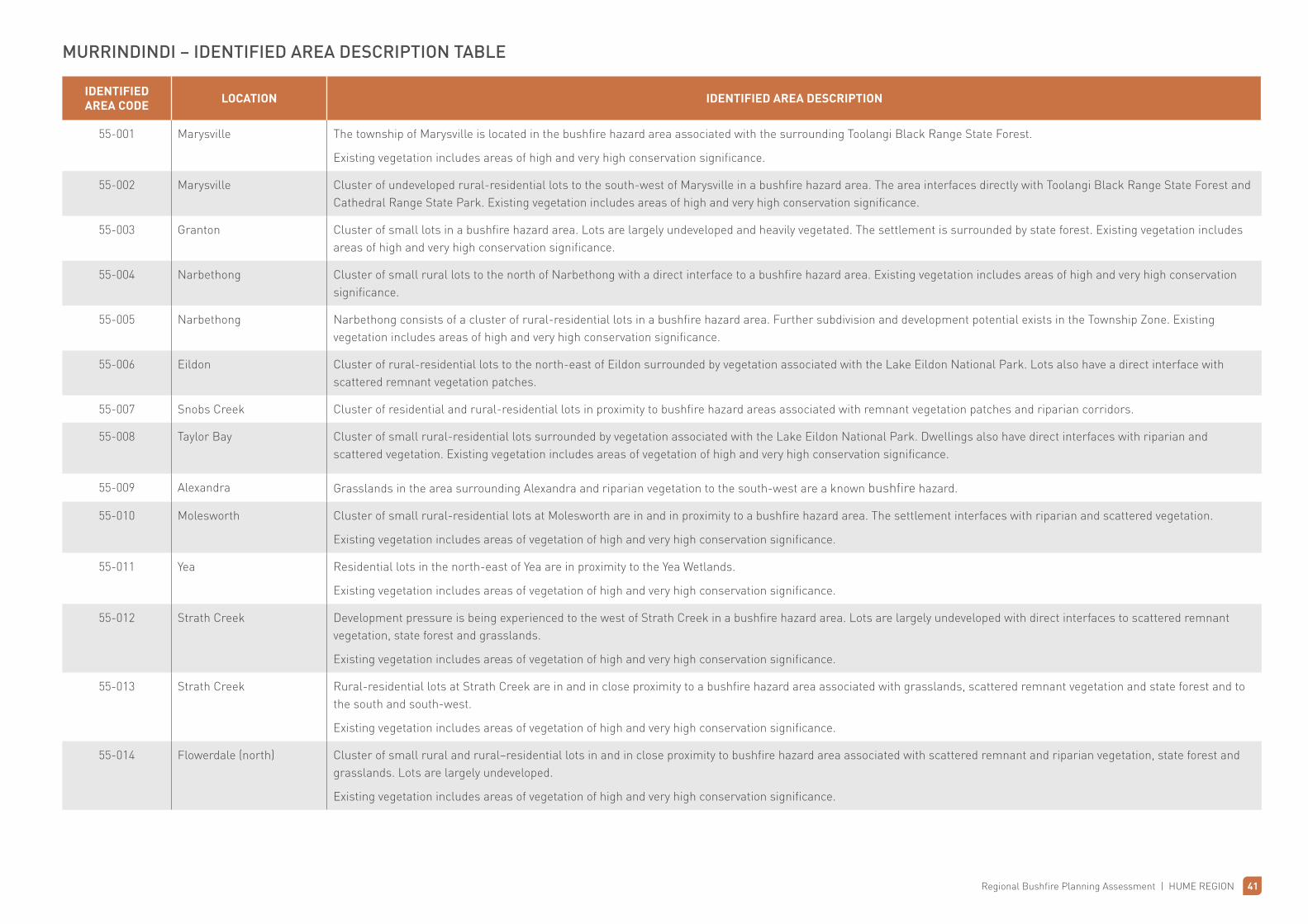
MURRINDINDI – IDENTIFIED AREA DESCRIPTION TABLE
IDENTIFIED AREA CODE LOCATION IDENTIFIED AREA DESCRIPTION
55-001 Marysville The township of Marysville is located in the bushfire hazard area associated with the surrounding Toolangi Black Range State Forest.
Existing vegetation includes areas of high and very high conservation significance.
55-002 Marysville Cluster of undeveloped rural-residential lots to the south-west of Marysville in a bushfire hazard area. The area interfaces directly with Toolangi Black Range State Forest and Cathedral Range State Park. Existing vegetation includes areas of high and very high conservation significance.
55-003 Granton Cluster of small lots in a bushfire hazard area. Lots are largely undeveloped and heavily vegetated. The settlement is surrounded by state forest. Existing vegetation includes areas of high and very high conservation significance.
55-004 Narbethong Cluster of small rural lots to the north of Narbethong with a direct interface to a bushfire hazard area. Existing vegetation includes areas of high and very high conservation significance.
55-005 Narbethong Narbethong consists of a cluster of rural-residential lots in a bushfire hazard area. Further subdivision and development potential exists in the Township Zone. Existing vegetation includes areas of high and very high conservation significance.
55-006 Eildon Cluster of rural-residential lots to the north-east of Eildon surrounded by vegetation associated with the Lake Eildon National Park. Lots also have a direct interface with scattered remnant vegetation patches.
55-007 Snobs Creek Cluster of residential and rural-residential lots in proximity to bushfire hazard areas associated with remnant vegetation patches and riparian corridors.
55-008 Taylor Bay Cluster of small rural-residential lots surrounded by vegetation associated with the Lake Eildon National Park. Dwellings also have direct interfaces with riparian and scattered vegetation. Existing vegetation includes areas of vegetation of high and very high conservation significance.
55-009 Alexandra Grasslands in the area surrounding Alexandra and riparian vegetation to the south-west are a known bushfire hazard.
55-010 Molesworth Cluster of small rural-residential lots at Molesworth are in and in proximity to a bushfire hazard area. The settlement interfaces with riparian and scattered vegetation.
Existing vegetation includes areas of vegetation of high and very high conservation significance.
55-011 Yea Residential lots in the north-east of Yea are in proximity to the Yea Wetlands.
Existing vegetation includes areas of vegetation of high and very high conservation significance.
55-012 Strath Creek Development pressure is being experienced to the west of Strath Creek in a bushfire hazard area. Lots are largely undeveloped with direct interfaces to scattered remnant vegetation, state forest and grasslands.
Existing vegetation includes areas of vegetation of high and very high conservation significance.
55-013 Strath Creek Rural-residential lots at Strath Creek are in and in close proximity to a bushfire hazard area associated with grasslands, scattered remnant vegetation and state forest and to the south and south-west.
Existing vegetation includes areas of vegetation of high and very high conservation significance.
55-014 Flowerdale (north) Cluster of small rural and rural–residential lots in and in close proximity to bushfire hazard area associated with scattered remnant and riparian vegetation, state forest and grasslands. Lots are largely undeveloped.
Existing vegetation includes areas of vegetation of high and very high conservation significance.
42 Regional Bushfire Planning Assessment | HUME REGION
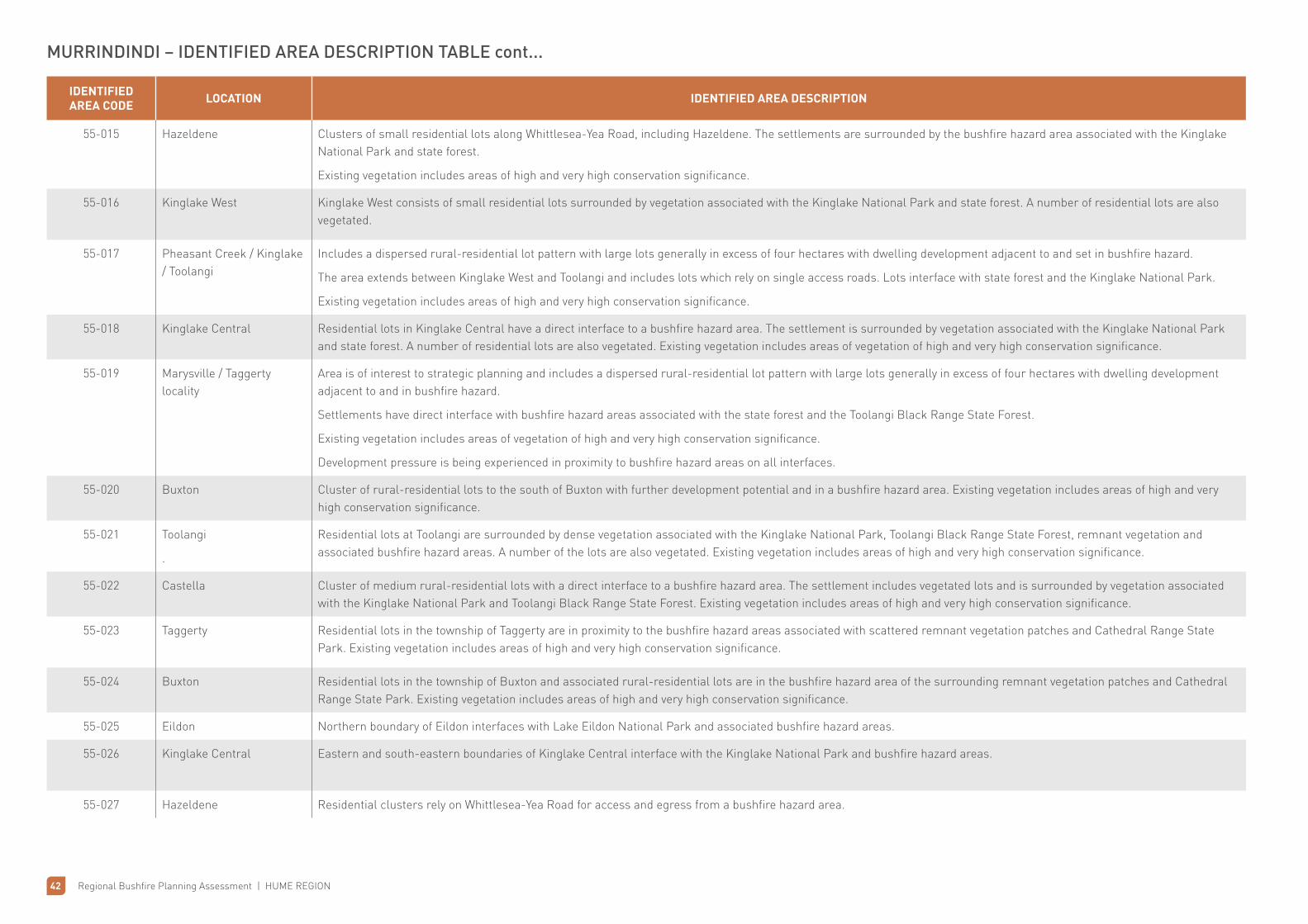
IDENTIFIED AREA CODE LOCATION IDENTIFIED AREA DESCRIPTION
55-015 Hazeldene Clusters of small residential lots along Whittlesea-Yea Road, including Hazeldene. The settlements are surrounded by the bushfire hazard area associated with the Kinglake National Park and state forest.
Existing vegetation includes areas of high and very high conservation significance.
55-016 Kinglake West Kinglake West consists of small residential lots surrounded by vegetation associated with the Kinglake National Park and state forest. A number of residential lots are also vegetated.
55-017 Pheasant Creek / Kinglake / Toolangi
Includes a dispersed rural-residential lot pattern with large lots generally in excess of four hectares with dwelling development adjacent to and set in bushfire hazard.
The area extends between Kinglake West and Toolangi and includes lots which rely on single access roads. Lots interface with state forest and the Kinglake National Park.
Existing vegetation includes areas of high and very high conservation significance.
55-018 Kinglake Central Residential lots in Kinglake Central have a direct interface to a bushfire hazard area. The settlement is surrounded by vegetation associated with the Kinglake National Park and state forest. A number of residential lots are also vegetated. Existing vegetation includes areas of vegetation of high and very high conservation significance.
55-019 Marysville / Taggerty locality
Area is of interest to strategic planning and includes a dispersed rural-residential lot pattern with large lots generally in excess of four hectares with dwelling development adjacent to and in bushfire hazard.
Settlements have direct interface with bushfire hazard areas associated with the state forest and the Toolangi Black Range State Forest.
Existing vegetation includes areas of vegetation of high and very high conservation significance.
Development pressure is being experienced in proximity to bushfire hazard areas on all interfaces.
55-020 Buxton Cluster of rural-residential lots to the south of Buxton with further development potential and in a bushfire hazard area. Existing vegetation includes areas of high and very high conservation significance.
55-021 Toolangi
.
Residential lots at Toolangi are surrounded by dense vegetation associated with the Kinglake National Park, Toolangi Black Range State Forest, remnant vegetation and associated bushfire hazard areas. A number of the lots are also vegetated. Existing vegetation includes areas of high and very high conservation significance.
55-022 Castella Cluster of medium rural-residential lots with a direct interface to a bushfire hazard area. The settlement includes vegetated lots and is surrounded by vegetation associated with the Kinglake National Park and Toolangi Black Range State Forest. Existing vegetation includes areas of high and very high conservation significance.
55-023 Taggerty Residential lots in the township of Taggerty are in proximity to the bushfire hazard areas associated with scattered remnant vegetation patches and Cathedral Range State Park. Existing vegetation includes areas of high and very high conservation significance.
55-024 Buxton Residential lots in the township of Buxton and associated rural-residential lots are in the bushfire hazard area of the surrounding remnant vegetation patches and Cathedral Range State Park. Existing vegetation includes areas of high and very high conservation significance.
55-025 Eildon Northern boundary of Eildon interfaces with Lake Eildon National Park and associated bushfire hazard areas.
55-026 Kinglake Central Eastern and south-eastern boundaries of Kinglake Central interface with the Kinglake National Park and bushfire hazard areas.
55-027 Hazeldene Residential clusters rely on Whittlesea-Yea Road for access and egress from a bushfire hazard area.
MURRINDINDI – IDENTIFIED AREA DESCRIPTION TABLE cont...

Regional Bushfire Planning Assessment | HUME REGION 43
IDENTIFIED AREA CODE LOCATION IDENTIFIED AREA DESCRIPTION
55-028 Kinglake West Multiple clusters of dwellings rely on single constructed roads for access and egress from bushfire hazard areas.
55-029 Taylor Bay Cluster of rural-residential dwellings at Taylor Bay rely on a single road for access and egress from a bushfire hazard area.
55-030 Hazeldene Silver Creek Road is the only access and egress point for a cluster of rural-residential lots in a bushfire hazard area.
55-031 Hazeldene Long Gully Road is a single access road for a cluster of rural-residential lots in a bushfire hazard area.
MURRINDINDI – IDENTIFIED AREA DESCRIPTION TABLE cont...