Embed Size (px)
Citation preview

Seminar:
Bushfire Management Overlay
Subdivision Design
Focus on applying defendable space
March 2013

Bushfire Management Overlay (BMO)
• The BMO mapping is applied to the areas that have
the highest bushfire risk.
• A planning permit is required to subdivide land,
construct a building or construction or carry out
works.
• Applications in a BMO must meet the planning
provisions contained in:
Clause 44.06 – Bushfire Management Overlay; &
Clause 52.47 – Bushfire Protection: Planning
Requirements

Specific application requirements for subdivision
Locality and Site Description• Locality (Site) Plan
Bushfire management statement• Report
• Bushfire Site Assessment
• BMO Subdivision Plan
• Vegetation Management Plan

Relevant standards to address:
Subdivision
• BF1 (General requirements)
• BF2 (Residential lots)
All development
• BF3 (Location)
• BF4 (Siting and layout)
• BF5 (Bushfire protection measures)
Buildings and works
• BF6 (Defendable space for dwellings)
• BF7 (Defendable space for industry, office and retail)
• BF8 (Defendable space for other occupied buildings)
• BF9 (Defendable space location)
• BF10 (Water supply and access)
Clause 52.47 - Bushfire Protection: Planning Requirements
4

5
The BMO objectives, standards and mandatory standards
(Clause 52.47)

Subdivision objective – Standard BF1 & BF2
Ensure that subdivision of land that would result in unacceptable risk
to human life is not permitted.
Standard BF1 (general – All lots to be created):
• Ensure all lots created are capable of providing bushfire protection measures
• For ten lots or more, consider need for perimeter road adjoining bushfire
hazard
Standard BF2 (Residential lots):
• Static water supply and access/egress that meet the needs of the relevant fire
authority.
• For ten lots or more, defendable space of a single dwelling to be BAL 19 or less.
• For less than ten lots, defendable space of a single dwelling to be BAL 29 or less.

Permit for a residential lot requires a section 173
agreement that sets out:
• Exemption from planning permit requirement for building and
works (i.e. construction of a dwelling) under Clause 44.06-1.
• Building envelope and defendable space to achieve approved
Bushfire Attack Level (BAL).
• Vegetation management requirements to implement defendable
spaces.
• Access and water supply requirements.
7
Clause 44.06-4 Mandatory Condition for subdivision:

All development – Standard BF3, BF4 & BF5
8
Essential that bushfire be considered early in the design process.
• Location objective - landscape scale (Standard BF3).
• Siting and layout objective (Standard BF4)
• Bushfire protection measures objective (Standard BF5)

9
Subdivision - Location, Layout & Siting

10
Subdivision - Location, Layout & Siting

11
Defendable Space & Construction Requirements
- Mandatory Standards BF6.1, BF7.1 & 8.1

12
Defendable space and construction requirements
• Must be calculated in accordance with Table 1 or 2 of
Clause 52.47 to limit radiant heat and ember attack

AS 3959-2009 Model
• In essence the calculation of radiant heat
under AS 3959 methodology determine:
• How a fire is likely to move across the landscape
• The flame length, and
• How this flame will emit radiation and how that
energy will be received by a structure
(Radiant heat exposure)


AS 3959-2009 Model

Defendable Space Table 1 & 2 of Clause 52.47

Bushfire Site Assessment (Example - Single Site)

Bushfire Site Assessment (Example - Subdivision)
Table – Vegetation, Slope, Construction Requirement & Defendable Space

19
Subdivision – Defendable space location

20
Subdivision - Defendable space location

Subdivision - Defendable space location
21

22
Subdivision – communal (open space) areas

23
Subdivisions that create public open space or communal land
• Management agreement to implement defendable space
- Agreement to be provided from responsible party
- Outline defendable space prescriptions
- To be applied in perpetuity
- Section 173 agreement where land is privately owned
• Management agreement to be implemented prior to
Statement of Compliance
Subdivision – communal (open space) areas

24
Standard BF1 & BF2 – additional matters
• BF 1 subdivisions- defendable space should
adequately reflect the use of the land
- E.g. Rural land BAL 12.5 defendable space
- Siting constraints, landscape risk and
surrounding density of development may allow
for less defendable space than 12.5
• May consider a section 173 agreement for all
subdivisions (i.e. including rural land) for the
purpose of dwelling permit exemption, if
appropriate.
• Defendable space to be implemented prior to
Statement of Compliance

25
Subdivision containing Existing Development
• Subdivision should not create a lot that would not
get a future permit to develop the land in line with
its zoning
• Existing buildings BAL defendable space
commensurate to existing construction standard
• Where BAL 12.5 defendable space is not being
achieved should demonstrate subdivision will not
increase the risk
• Defendable space on the allotment rather than
relying on a 173 Agreement

Proposal:
• Subdivision.
• Some lots are at significant
fire risk (possible flame
contact) and cannot achieve
BAL 40.
• Residential 1 (adjoining PUZ
– bushland reserve to the
south).
• Overlays: SLO, BMO, DPO,
ESO (Part).
26
Subject land
Activity: Subdivision design

Activity: Existing subdivision pattern
27
Bushland reserve (Woodland)
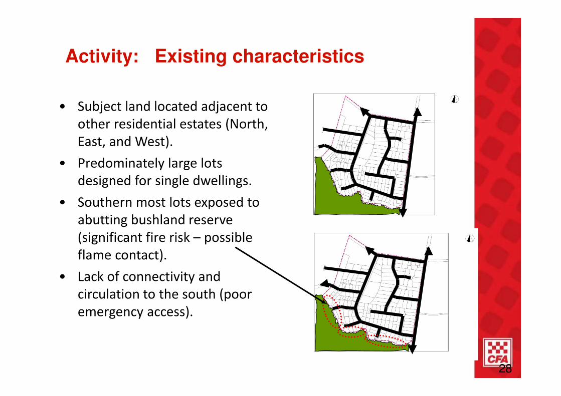
• Subject land located adjacent to
other residential estates (North,
East, and West).
• Predominately large lots
designed for single dwellings.
• Southern most lots exposed to
abutting bushland reserve
(significant fire risk – possible
flame contact).
• Lack of connectivity and
circulation to the south (poor
emergency access).
Activity: Existing characteristics
28

• Some lots are at significant fire risk (possible flame
contact).
• If we had our time again, what subdivision design changes
could be made to achieve BAL 19?
Activity: Subdivision design
29

Activity: Outcome of design review
• Southern-most lots exposed to
bushland reserve (significant fire
risk – possible flame contact).
• Remainder of subdivision has a
reduced fire risk.
• Full re-design not required.
• Re-design should consider the
risks posed to southern lots with a
view to redesigning these lots.
30

Activity: Outcome – Establishing the main road network
31
• Main and secondary
road network
identified.
• Majority of road
network to remain
unchanged.
• BAL 19 defendable
space (37 metres)
identified to assist in
restructuring the
southern perimeter
road network.

Activity: Outcome – Fire Access Tracks
• Fire Access
Tracks added to
improve
emergency
vehicle access
adjacent to fire
risk.
32

Activity: Outcome – Perimeter roads
• Cul-de-sacs
adjacent to
bushland reserve
re-considered.
• Perimeter roads
introduced adjacent
to fire risk:
- Improved
circulation for
residents and
emergency
vehicles.
- Provides a buffer
between
residential lots
and major fire
risk.
33

Activity: Outcome – Lot re-design
• Lots adjacent to
fire risk reduced,
re-designed, and
re-orientated so as
to achieve
defendable space
requirements.
• Building envelopes
located outside of
37 metre
defendable space
distance to achieve
BAL 19.
• Building and
population density
increased away
from fire risk.
- Additional lots
created.34

Activity: Comparison
35

Key messages
1
2Looking north on neighbouring land
• Identifying the bushfire risk and defendable space requirements up front is
critical.
• In this instance, a response requiring re-design of whole subdivision was
not required.
• Small design changes led to significant reduction of bushfire risk through:
• Minor Lot reconfiguration (predominately along the southern
boundary),
• Fire Access Tracks,
• Perimeter Road.
• Minor increase in road space / easements.
• Major benefits:
• Provisions facilitated the development of a potentially “stuck site”.
• No net loss of dwellings.
• No reliance on reaching land management agreement on adjoining
land.
36

CFA REQUIREMENTSTo guide assessment of subdivisions,
CFA has published requirements
www.cfa.vic.gov.au
Residential subdivisions must be designed and located to
provide ready access for fire trucks and water supply

CFA REQUIREMENTS
Pretty simple really
• Fire trucks need water for firefighting
• Fire trucks need to access the water source and the
residence
• The response to a fire is time critical, delays must be
avoided.
• Firefighters must be able to access equipment on their
vehicle efficiently and effectively

CFA REQUIREMENTS
INAPPROPRIATELY DESIGNED AND SITED SUBDIVISIONS
RISKS
• Emergency vehicles can not access incident
• Insufficient water supply to adequately fight fire and provide
protection for fire fighters

WATER SUPPLY REQUIREMENTS

Water Supply Requirements

WATER SUPPLY REQUIREMENTS
Hydrant Location
200m
< 60m
A
B
A + B = 120m Maximum


ACCESS REQUIREMENTS
8.2m
3.2m
3.1mMirror to mirror

ACCESS REQUIREMENTS
11.8m
3.9m

ACCESS REQUIREMENTS
7m- 7.5m 5.5m In between

ACCESS
REQUIREMENTS:

ACCESS REQUIREMENTS

‘CREATING A SAFER
COMMUNITY’For more information visit
www.cfa.vic.gov.au