Embed Size (px)
Citation preview
TITLE 27: SUBDIVISIONS
1

2 Jefferson County - Subdivisions
TITLE 27: SUBDIVISIONS
Preamble
Article 1: General Provisions
27-1-1 Title27-1-2 Purpose27-1-3 Authority and jurisdiction27-1-4 Interpretation, conflict and separability27-1-5 Saving provision27-1-6 Repealer27-1-7 Amendments27-1-8 Resubdivision of land27-1-9 Vacation27-1-10 Variances27-1-11 Establishment of subdivision control27-1-12 Appeals27-1-13 Definitions and terms
Article 2: Procedure for Submission of Plats
27-2-1 General27-2-2 Advisory meeting with Plan Commission27-2-3 Preliminary plat approval27-2-4 Approval of construction plans27-2-5 Final plat approval
Article 3: General Requirements and Minimum Standards for Improvements
27-3-1 General improvements27-3-2 Plats crossing municipal boundaries27-3-3 Subdivision name27-3-4 Suitability of the land for subdivision development27-3-5 Lot improvements27-3-6 Monuments27-3-7 Streets
3
4 Jefferson County - Subdivisions
27-3-8 Blocks27-3-9 Community assets27-3-10 Utility easements27-3-11 Sidewalks27-3-12 Culverts27-3-13 Drainage and storm sewers27-3-14 Dedication of drainage easements27-3-15 Water supply improvements27-3-16 Sanitary sewer improvements27-3-17 Fire Department subdivision regulations
Article 4: Assurance for Completion of Improvements
27-4-1 Completion of improvements27-4-2 Posting of bonds
Article 5: Administration
27-5-1 Inspection27-5-2 Acceptance of construction27-5-3 Release or reduction of performance bond27-5-4 Enforcement of violations27-5-5 Penalties27-5-6 Repeal of conflicting regulations, effective date and enactment
Appendix
PREAMBLE
An ordinance establishing subdivision regulations for the County of Jefferson, Indiana, prescribingminimum requirements with respect to subdivision; providing for the procedure for subdividing; designstandards of streets, blocks, lots, easements, public utilities, and improvements; the fixing of fees forprocessing; and providing for the enforcement of the provisions of this ordinance.
WHEREAS, land subdivision is the first step in the process of community expansion; and
WHEREAS, once land has been divided into streets, blocks, lots and open spaces, a pattern has beenestablished which usually determines how well community needs for residence, business and industrywill be met; and
Subdivisions 5
WHEREAS land subdivision determines to a great extent how well the community will be able todeal with traffic circulation problems, drainage problems and the demand for home sites, and howefficiently it will be able to provide the many services demanded of it; and
WHEREAS, subdivided land areas soon become a public responsibility in that roads, streets,drainage and public utilities must be maintained and various public services customary to urban areasmust be provided; and
WHEREAS, the guidance of land development in harmony with community objectives is a matterof serious public concern and community welfare; and
WHEREAS, it is the interest of the public, the developer and future land owners that subdivisionsbe conceived, designed and developed in accordance with sound minimum standards; and
WHEREAS, state law empowers the county to enact a subdivision regulations ordinance and toprovide for its administration, enforcement and amendment; and
WHEREAS, the Board of County Commissioners deems it necessary for the purpose of providingfor the harmonious development and coordinated layout for the subdivided area; for the properarrangement of streets; for adequate and convenient open spaces for traffic, utilities, recreation, light,air and access of firefighting equipment; for avoidance of population congestion through requirementsfor minimum lot widths and lot area; for adequate sanitary facilities; and for reducing flood damagepotentials to the greatest extent possible.
NOW THEREFORE BE IT ORDAINED BY THE BOARD OF COUNTY COMMISSIONERS OFTHE COUNTY OF JEFFERSON, INDIANA:
Article 1: General Provisions
§ 27-1-1 TITLE.
These regulations shall be known and cited as the “Subdivision Regulations of the County ofJefferson, Indiana”.(Res. passed 5-5-2004; Ord. 2004-2, passed 5-14-2004)
§ 27-1-2 PURPOSE.
The purpose of these regulations is to protect and promote the public health, safety and generalwelfare, and to provide for:
6 Jefferson County - Subdivisions
(A) Guidance for future growth and development in accordance with the comprehensive planningprocess;
(B) Adequate air, light and privacy, and to prevent overcrowding of the land and undue congestion;
(C) Protection of the character and the social and economic stability of all parts of the area, and toencourage the orderly and beneficial development of all parts;
(D) Protection and conservation of the value of land, buildings and other improvements upon theland, and to minimize the conflicts among the uses of land and buildings;
(E) Guidance of public and private policy and action in order to assure adequate and efficienttransportation, water, sewerage, schools, parks, drainage and other public requirements and facilities;
(F) Avoidance of scattered and uncontrolled subdivision of land that would result in the unnecessaryimposition of an excessive expenditure of public funds for the supply of services that are a part ofcommunity infrastructure;
(G) Establishment of reasonable standards of design and minimum requirements for the creation,installation and improvement of physical facilities, which are, or will be, maintained for the benefit ofgeneral public;
(H) Establishment of reasonable standards and procedures for subdivisions and resubdivision, inorder to further the orderly layout and use of land, and to ensure proper legal descriptions andmonumenting of subdivided land;
(I) Prevention of the pollution of air and water; provision of drainage facilities and the safeguardingof the water table; and the encouragement of wise use and management of natural resources in order topreserve the integrity, stability, natural beauty and topography, and the value of land; and
(J) Administration of these regulations by defining the powers and duties of approval authorities;and the manner and form of making, filing and processing of any plat.(Res. passed 5-5-2004; Ord. 2004-2, passed 5-14-2004)
§ 27-1-3 AUTHORITY AND JURISDICTION.
(A) This chapter, which was enacted pursuant to state home rule and planning enabling legislation(I.C. 36-1-3-4 and the 36-7-4-700 series, as amended), authorizes the County Plan Commission to reviewand approve or disapprove plats for subdivision within the jurisdiction of the county which show lots,blocks or sites with or without new streets or highways. With regard to this chapter, the authority andthe jurisdiction shall include the unincorporated portion of the county and exclude the corporate limits
Subdivisions 7
and the unincorporated area within the two-mile planning limits of the City of Madison and the Townof Hanover, Indiana, as may be amended by subsequent annexation, except for subsection (C) below.This authority extends to the development of undeveloped portions of previously recorded plats.
(B) No improvement location permit, building permit or certificate of occupancy shall be issued forany parcel or plat of land which was created by subdivision after the effective date of, and not inconformity with, the provisions of these subdivision regulations, and no excavation of land orconstruction of any public or private improvements shall take place or be commenced except inconformance with the regulations contained herein and including the construction standards adopted bythe county.
(C) With respect to road standards in any subdivision within the two-mile fringe of the City ofMadison or the Town of Hanover, the applicant shall be bound and governed by the more restrictive orstringent of either the county subdivision construction standards or those of the City of Madison or Townof Hanover, whichever is applicable.(Res. passed 5-5-2004; Ord. 2004-2, passed 5-14-2004)
§ 27-1-4 INTERPRETATION, CONFLICT AND SEPARABILITY.
(A) In their interpretation and application, the provisions of these regulations shall be held to be theminimum requirements for the promotion of the public health, safety and general welfare.
(B) (1) Public provisions. The regulations are not intended to interfere with, abrogate or annul anyother ordinance, rule or regulation, statute or other provision of law. Where any provision of theseregulations imposes restrictions different from those imposed by any other provision of these regulationsor any other ordinance, rule or regulation or other provision of law, whichever provisions are morerestrictive or impose higher standards shall control.
(2) Private provisions. The regulations are not intended to abrogate any easement, covenantor any other private agreement or restriction; provided that, where the provisions of these regulationsare more restrictive or impose higher standards or regulations than the easement, covenant or otherprivate agreement or restriction, the requirements of these regulations shall govern. Where the provisionsof the easement, covenant or private agreement or restriction impose duties and obligations morerestrictive, or higher standards than the requirements of these regulations, or the determinations of theCommission in approving a subdivision or in enforcing these regulations, and the private provisions arenot inconsistent with these regulations or determinations there under, then the private provisions shallbe operative and supplemental to these regulations and determinations made there under.
(C) If any part or provision of these regulations or application thereof to any person orcircumstances is adjudged invalid by any court of competent jurisdiction, the judgment shall be confinedin its operation to the part, provision or application directly involved in the controversy in which the
8 Jefferson County - Subdivisions
judgment shall have been rendered and shall not affect or impair the validity of the remainder of theseregulations or the application thereof to other persons or circumstances. The county hereby declares thatit would have enacted the remainder of these regulations even without any such part, provision orapplication.(Res. passed 5-5-2004; Ord. 2004-2, passed 5-14-2004)
§ 27-1-5 SAVING PROVISION.
These regulations shall not be construed as abating any action now pending under, or by virtue of,prior existing subdivision regulations, or as discontinuing, abating, modifying or altering any penaltyaccruing or about to accrue, or as affecting the liability of any person, firm or corporation, or as waivingany right of the county under any section or provision existing at the time of adoption of theseregulations, or as vacating or annulling any rights obtained by any person, firm or corporation, by lawfulaction of the county, except as shall be expressly provided for in these regulations.(Res. passed 5-5-2004; Ord. 2004-2, passed 5-14-2004)
§ 27-1-6 REPEALER.
Upon adoption of this Ord. 2004-2 according to law, the subdivision regulations ordinance of thecounty, adopted 6-30-1970, as amended are hereby repealed, except for the sections expressly retainedherein.(Res. passed 5-5-2004; Ord. 2004-2, passed 5-14-2004)
§ 27-1-7 AMENDMENTS.
For the purpose of protecting and promoting public health, safety and general welfare, the Boardof County Commissioners may from time to time amend the provisions imposed by these regulations.The Plan Commission shall hold public hearings on all proposed amendments in the manner prescribedby law.(Res. passed 5-5-2004; Ord. 2004-2, passed 5-14-2004)
§ 27-1-8 RESUBDIVISION OF LAND.
(A) Procedure for resubdivision. For any change in a map of an approved or recorded subdivisionplat, if the change affects any street layout shown on the map, or area reserved thereon for public use,or any lot line, or if it affects any map or plan legally reached prior to the adoption of any regulationscontrolling subdivisions, the parcel shall be approved by the Commission by the same procedure, rulesand regulations as for a subdivision.
Subdivisions 9
(B) Procedure for subdivisions where future resubdivision is indicated. Whenever a parcel of landis subdivided and the subdivision plat shows one or more lots containing more than one acre of land andthere are indications that the lots will eventually be re-subdivided into smaller building sites, theCommission may require that the parcel of land allow for the future opening of streets and the ultimateextension of adjacent streets. Easements providing for the future opening and extension of the streets maybe made a requirement of the plat.(Res. passed 5-5-2004; Ord. 2004-2, passed 5-14-2004)
§ 27-1-9 VACATION.
(A) Any recorded plat or part thereof may be vacated only in accordance with I.C. 36-7-3, asamended.
(B) Power is given to the county to vacate by proper ordinance any existing plat and addition to thecounty or the part or parts thereof as the county may deem advantageous and best for its interests, andthe power granted shall be exercised by the county upon the petition of the owner or all of the ownersof lots or lands in the plat or addition.
(C) The ordinance vacating the plat or addition shall specify whether, and, if any, what publichighways, streets, alleys and public grounds thereof are to be retained by the county; otherwise, theways, streets and public grounds shall upon the vacation revert to the owner or owners of lots or landsabutting the same in proportion to the respective ownerships of the lots or grounds. In case of total orpartial vacation of the plat or addition, the ordinance providing therefore shall be, at the cost of theowner or owners, certified to the office of the County Recorder and be there recorded by the owner orowners. Whereupon the officer shall note the total or partial vacation of the plat or addition by writingin plain and legible letters upon the plat or portion thereof so vacated the word “vacated”, and also makeon the same, reference to the volume and page in which the ordinance of vacation is recorded; and theowner or owners of the lots and lands in a plat so vacated shall cause the same and the proportionate partof the abutting highway, streets, alleys and public grounds so vacated to be replatted and numbered bythe County Surveyor. When the replat so executed is acknowledged by the owner or owners and isrecorded in the office of the County Recorder, the property so replatted may be conveyed and assessedby the numbers given in the replat.(Res. passed 5-5-2004; Ord. 2004-2, passed 5-14-2004)
§ 27-1-10 VARIANCES.
(A) Where the Plan Commission finds that extraordinary hardships or practical difficulties mayresult from strict compliance with these regulations and/or the purposes of these regulations may beserved to a greater extent by an alternative proposal, it may approve variances to these subdivisionregulations so that substantial justice may be done and the public interest secured; provided that, the
10 Jefferson County - Subdivisions
variance shall not have the effect of nullifying the intent and purpose of these regulations; and furtherprovided the Plan Commission shall not approve variances unless it shall make findings, based upon theevidence presented to it in each specific case, that:
(1) The granting of the variance will not be detrimental to the public safety, health or welfare,or injurious to other property;
(2) The conditions upon which the request for a variance is based are unique to the propertyfor which the variance is sought and are not applicable generally to other property;
(3) Because of the particular physical surroundings, shape or topographical conditions of thespecific property involved, a particular hardship to the owner would result, as distinguished from a mereinconvenience, if the strict letter of these regulations is carried out;
(4) The variance will not in any manner vary the provisions of the Zoning Ordinance orComprehensive Plan as interpreted by the Commission or its agents; and/or
(5) Where the variance impacts on design and construction of public facilities, all appropriatepublic agencies have been given ample time to comment in writing to the Commission.
(B) In approving variances, the Plan Commission may require such conditions as will, in itsjudgment, secure substantially the objectives of the standards or requirements of these regulations.
(C) A petition for any such variance shall be submitted in writing by the subdivider at the time whenthe preliminary plat is filed for the consideration of the Commission. The petition shall state fully thegrounds for the application and all of the facts relied upon by the petitioner.
(D) Financial disadvantage to the property owner is not proof of hardship within the purpose of thischapter.
(E) A comprehensive group housing, commercial or industrial development, including thelarge-scale construction of housing, commercial or industrial units together with necessary drives andways of access, may be approved by the Plan Commission although the design of the project does notinclude standard street, lot and subdivision arrangements; provided that, departure from the standardsof these regulations can be made without destroying their intent and is in accordance with the provisionsof the Zoning Ordinance relating to planned development.
(F) Variance will not be allowed to enlarge exception (g) to the definition of a subdivision.(Res. passed 5-5-2004; Ord. 2004-2, passed 5-14-2004)
Subdivisions 11
§ 27-1-11 ESTABLISHMENT OF SUBDIVISION CONTROL.
(A) No owner, or agent of the owner, of any parcel of land located in a proposed subdivision shalltransfer or sell any parcel before a plat of the subdivision has been approved by the Commission, inaccordance with the provisions of these regulations, and filed with the County Recorder.
(B) No public board, agency, commission, official or other authority shall proceed with theconstruction of or authorize the construction of the public improvements required by these regulationsuntil the proposed subdivision has been approved by the Plan Commission in accordance with theseregulations.
(C) No improvement location permit or building permit required under County Building Code,(§ 36-7-9-3 of the County Code), the Zoning Ordinance or this chapter shall be issued on any propertysubject to this chapter until the provisions of this chapter have been compiled with.(Res. passed 5-5-2004; Ord. 2004-2, passed 5-14-2004)
§ 27-1-12 APPEALS.
Any decision or requirement of the Plan Commission made under the authority of this chapter issubject to the right of appeal and review by certiorari provided written appeal is taken no more than 30days from the Commission action.(Res. passed 5-5-2004; Ord. 2004-2, passed 5-14-2004)
§ 27-1-13 DEFINITIONS AND TERMS.
(A) General.
(1) For the purpose of these regulations, certain numbers, abbreviations, terms and words usedherein shall be used, interpreted and defined as set forth in this section.
(2) Unless the context clearly indicates to the contrary, words used in the present tense includethe future tense, words used in the plural number include the singular; the word “herein” means “inthese regulations”, and the word “regulations” means “these regulations”.
(3) A “person” includes a corporation, a partnership, and an incorporated association ofpersons such as a club; “shall” is always mandatory; “used” or “occupied”, as applied to any land orbuilding, shall be construed to include the words “intended, arranged or designed to be used oroccupied”.
12 Jefferson County - Subdivisions
(B) Definitions. For the purpose of this title, the following definitions shall apply unless the contextclearly indicates or requires a different meaning.
ACCESSORY BUILDING. A building or use subordinate to another structure or use detachedfrom but located on the same lot and which does not change or alter the character of the premises andwhich is not used for human occupancy.
ADVERTISING SIGN. Any structure, object or device erected, maintained or used foradvertising purposes, related to the permitted principal use of the premises upon which it is located. Thisdefinition does not include the term “billboard”.
AGRICULTURE. The art or science of cultivating the ground, and raising and harvesting crops.Also often includes feeding, breeding and management of livestock; tillage; husbandry; farming; and,in a broader sense, the production of plants and animals useful to man, including, to a variable extent,the preparation of those products for human’s use and their disposal by marketing or other means ofdistribution. This includes the use of land for farming, dairying, pasturage, agriculture, apiculture,horticulture, floriculture, viticulture, animal and poultry husbandry, and the necessary accessory usesfor packing, treating or storing the produce; provided, however, that:
(a) The operation of any such accessory uses shall be secondary to that of normalagricultural activities;
(b) The above uses shall not include the feeding or sheltering of animals or poultry inpenned enclosures within 100 feet of any residential district; or
(c) The term AGRICULTURE does not include the operation or maintenance of acommercial stockyard.
AIRPORT. Any location, either on land or water, or structure that is designed or used for thelanding and taking-off of aircraft, including all necessary buildings and facilities, if any.
ALLEY. See STREET.
ALTERATION. Any change, addition or modification in construction, or any change in thestructural members of a building, such as bearing walls, columns, beams or girders.
APARTMENT. A room or suite of rooms in a multiple dwelling or where more than one livingunit is established in any building intended, designed, used or suitable for use by one or more personsas a place of residence with kitchen facilities.
APPLICANT. The owner of land proposed to be subdivided or his or her representative.Consent shall be required from the legal owner of the premises.
Subdivisions 13
APPROPRIATE AGENCY or APPROPRIATE OFFICIAL. The agency or official that willinspect improvements. The APPROPRIATE AGENCY OR OFFICIAL for roads and drainage is theCounty Engineer; for water systems, the water company that will provide water service to thesubdivision; for sewer lines, the agency that will treat the sewage; for septic systems, the County HealthDepartment or the State Health Department.
ARTERIAL. See STREET.
AUCTION USE. A building or any specific closed or open area where merchandise isassembled and sold by a form of sale called an auction.
AUTOMOBILE SALES ROOM. The use of all or part of a building for the display and saleof new or used automobiles.
AUTOMOBILE SERVICE STATION. A building designed primarily for the supplying ofmotor fuel, oil, lubrication and accessories to motor vehicles, but excluding major repair and overhaul.
AUTOMOTIVE, MOBILE HOME, TRAVEL TRAILER, FARM IMPLEMENT ANDCONSTRUCTION MACHINERY SALES. The sale or rental of new or used motor vehicles, mobilehomes, travel trailers, farm implements and construction machinery, but not including major repair workexcept warranty and incidental repair of same, to be displayed and sold on the premises.
BASEMENT. A portion of the building having more than half its clear height below the averagegrade of the adjoining ground.
BASEMENT, EXPOSED. A portion of the building having less than half its clear height belowthe average grade of the adjoining ground.
BED AND BREAKFAST. A property occupied by an owner and/or operator providingovernight accommodations to guests, with or without meals for hire or pay, for the traveling orvacationing public. It does not include boarding house, rooming house, domiciliary hostel, group home,hotel or motel.
BILLBOARD. Any structure, object or device erected, maintained or used for advertisingpurposes not related to a principal use of the premises upon which it is located.
BLOCK. A tract of land bounded by streets, or a combination of streets and public parks,cemeteries, railroad rights-of-way, shorelines of waterways or boundary lines of municipalities.
BOARD. Board of Zoning Appeals.
14 Jefferson County - Subdivisions
BOARDING AND LODGING HOUSE. A building where, for compensation, lodging orlodging and meals are provided for three or more persons, not including members of the keeper’simmediate family, for prearrangement for definite periods.
BOND. Any form of security including a cash deposit, surety bond, collateral, property orinstrument of credit in an amount and form satisfactory to the Plan Commission. All BONDS shall beapproved by the Commission wherever a bond is required by these regulations.
BUILDING. Any roofed structure designed and built for the support, shelter enclosure orprotection of persons, animals, chattels or movable property of any kind.
BUILDING AREA. The maximum horizontal projected area of the principal and accessorybuildings, excluding open steps or terraces, unenclosed porches or architectural appurtenances projectednot more than two feet.
BUILDING CODE. Indiana Building Code, 1998 Edition, is an adaptation of the UniformBuilding Code (UBC).
BUILDING LINE. The line that established the minimum permitted distance on a lot betweenthe front line of a building and the street right-of-way line. A building shall not extend beyond theBUILDING LINE unless varied according to procedures in the Zoning Ordinance.
BUILDING, DETACHED. A building having no structural connection with another building.
BUILDING, FRONT LINE OF. The line of the face of the building nearest the front lot line.
BUILDING, HEIGHT OF. The vertical distance measured from the average elevation of theproposed finished grade at the front of the building to the highest point of the roof for flat roofs, to thedeck line of mansard roofs and to the mean height between eaves and ridges for gable, hip and gambrelroofs.
BUILDING, PRINCIPAL. A building in which is conducted the main or principal use of thelot on which the building is situated.
BUILDING SITE. An area proposed or provided and improved by grading, filling, excavationor other means for erecting pads or foundations for buildings.
BUSINESS, CONVENIENCE.
(a) Commercial establishments which cater to and can be located in close proximity to orwithin residential districts without creating excessive congestion, noise or other objectionable influences.
Subdivisions 15
(b) CONVENIENCE USES include, but need not be limited to, drugstores, beauty salons,barbershops, carryouts, dry cleaning and laundry facilities and small grocery stores, if the aggregate totalfloor area of the facilities does not exceed 10,000 square feet.
(c) Uses in this classification tend to serve the day-to-day needs of the neighborhood.
BUSINESS, GENERAL. Commercial uses which generally require locations on or near majorarterials and/or their intersections, and which tend, in addition to serving day-to-day needs of theneighborhood, to also supply the more durable and permanent needs of the whole community.GENERAL BUSINESS uses include, but need not be limited to, such activities as major supermarkets;stores that sell hardware, apparel, footwear, appliances and furniture; and various department anddiscount stores. Also included here may be drive-in banks.
BUSINESS, HIGHWAY. Commercial uses which generally require locations on or near majorarterials and/or their intersections, and which tend to serve the motoring public. HIGHWAY BUSINESSUSES include, but need not be limited to, such activities as filling stations, automotive sales and service,restaurants and motels and commercial recreation.
BUSINESS, OFFICE TYPE. Quasi-commercial uses which may often be transitional betweenretail business and/or industrial and residential uses. OFFICE BUSINESS generally accommodates suchoccupations as administrative, executive, professional, accounting, clerical and drafting. Institutionaloffices of a charitable, philanthropic, religious or educational nature are included here.
BUSINESS SERVICES. Any activity which renders services primarily to other commercial orindustrial enterprises or which services and repairs appliances and machines used in businesses andhomes.
BUSINESS, WHOLESALE. Business establishments that generally sell commodities andmaterials in large quantities or by the piece to retailers, jobbers or other wholesale establishments. Thesecommodities are basically for further resale, for use in the fabrication of a product or for use by abusiness service.
CAMP, PUBLIC. Any area or tract of land used or designed to accommodate two or moreautomobile house trailers, recreational vehicles, mobile homes or two or more camping parties, includingcabins, tents or other camping outfits.
CAPITAL IMPROVEMENTS PROGRAM. A proposed schedule for all future projects in orderof construction priority together with cost estimates and the anticipated means of financing each project.All major projects requiring the expenditure of public funds, over and above the annual localgovernment’s operating expenses, for the purchase, construction or replacement of the physical assetsfor the community are included.
16 Jefferson County - Subdivisions
CARPORT. A structure with a roof supported by columns and/or one or more solid walls forthe shelter of an automobile(s).
CELLULAR ANTENNA TOWER. A tower constructed for, or an existing facility that has beenadapted for, the location of transmission or related equipment to be used in the provision of cellulartelecommunications services or personal communications services.
CEMETERY. Land used or intended to be used for the burial of the human or animal dead anddedicated for cemetery purposes, including crematories, mausoleums and mortuaries if operated inconnection with and within the boundaries of the cemetery for which perpetual care and maintenance areprovided.
CENTRAL SEWERAGE SYSTEM. A community sewer system including collection andtreatment facilities established by the developer to serve a new subdivision in an outlying or generallyrural area.
CENTRAL WATER SYSTEM. A private water company formed by a developer to serve a newcommunity development in an outlying or generally rural area. It includes water treatment anddistribution facilities.
CHANNEL. A natural or artificial watercourse, with definite bed and banks to confine andconduct continuously or periodically flowing water.
CHARACTERISTICS OF USE. The use that is characteristic or the principal use of an areaof land, a building or structure.
CLASSIFICATION OF STREETS. Functional classification is defined as the process by whichstreets and roads are grouped into classes, or systems, according to the character of service they areintended to provide. Functional CLASSIFICATION can be applied in planning street and road systemdevelopment, determining the jurisdictional responsibility for particular systems, and in fiscal planning.Three main classes are generally accepted under the functional classification scheme: arterials, collectorsand locals.
CLINIC. A building used for the care, diagnosis and treatment of sick, ailing, infirm or injuredpersons, and those who are in need of medical and surgical attention, but which building does notprovide board, room or regular hospital care and services.
CLUB. Buildings and facilities, owned or operated by a corporation, association, person orpersons for a social, educational or recreational purpose, to which membership is required forparticipation, and not operated primarily for profit or to render a service which is customarily carriedon as a business.
COLLECTOR. See STREET.
Subdivisions 17
COMMERCIAL ENTERTAINMENT FACILITY. Any activity that is generally related to theentertainment field, such as a motion picture theater, carnival, cocktail lounge, nightclub and similarentertainment activities.
COMMISSION. The Plan Commission, appointed in accordance with I.C. 36-7-1.
COMPREHENSIVE PLAN. Inclusive physical, social and economic plans and policies ingraphic and verbal statement forms for the development of the county prepared and adopted by theCommission pursuant to the state acts, and including any part of the plan and/or policies separatelyadopted and any amendment to the plan and/or policies, or parts thereof.
CONDITIONAL USE. A special use permitted within a district other than a principallypermitted use, requiring a conditional use permit and approval of the Board of Zoning Appeals.CONDITIONAL USES permitted in each district are listed in the Official Schedule of DistrictRegulations or special exceptions.
CONDITIONAL USE PERMIT. A permit issued by the zoning inspector upon approval by theBoard of Zoning Appeals to allow a use other than a principally permitted use to be established withinthe district.
CONDOMINIUM. An estate consisting of an undivided interest in common in real property,in an interest or interests in real property, or in any combination thereof, together with a separate interestin real property, in an interest or interests in real property or in any combination thereof.
CONFINEMENT FEEDING. The confined feeding of animals for food, fur, or pleasurepurposes in lots, pens, ponds, sheds, barn buildings or any other structure where food is supplied to theanimals only by means other than grazing. The term, as defined by the State Department ofEnvironmental Management, means the feeding of 300 or more cattle, 600 or more swine or sheep or30,000 or more fowl that are housed (or penned) in a confined area.
CONSTRUCTION PLANS. The maps, drawings and textual descriptions accompanying asubdivision plat and showing the specific location and design of improvements to be installed in thesubdivision in accordance with the requirements of the Commission as a condition of the approval of theplat.
CONSTRUCTION STANDARDS. The county construction standards for development andpublic improvements, as adopted and amended.
COUNCIL. The County Council.
COUNTY ATTORNEY. The licensed attorney designated by the legally authorized body tofurnish legal assistance for the administration of these regulations in lieu of the Commission having itsown attorney.
18 Jefferson County - Subdivisions
COUNTY ENGINEER. The licensed engineer designated by the county to furnish engineeringassistance in the administration of these regulations.
COVENANT. A written promise or pledge.
CUL-DE-SAC. See STREET.
CULVERT. A drain that channels water under a bridge, street or driveway.
DEAD-END STREET. See STREET.
DEDICATION. The setting apart of land or interests in land for use by the public by ordinance,resolution or entry in the official minutes as by the recording of a plat.
DENSITY. A unit of measurement of the number of dwelling units per acre of land.
(a) GROSS DENSITY. The number of dwelling units per acre of the total land to bedeveloped, including public right-of-way.
(b) NET DENSITY. The number of dwelling units per acre of land when the acreageinvolved includes only the land devoted to residential uses, excluding public right-of-way.
DEVELOPER. Authorized agent(s) of a subdivider or the subdivider himself or herself. TheDEVELOPER may be the owner of land proposed to be subdivided or his or her representative, thesubdivider.
DISTRICT. A part of the county wherein restrictions of the Zoning Ordinance are uniform.
DRIVE-IN BUSINESS. An establishment with facilities for attracting and servicing prospectivecustomers traveling in motor vehicles which are driven onto the site where the business is carried on,where normally the customer remains in the vehicle for service, but shall not include car washingestablishments, drive-in theatres or service stations.
DRIVES, PRIVATE (DRIVEWAY). Vehicular streets and driveways, which have been gradedand graveled or surfaced with concrete, asphalt, crushed stone or other hard surfaces and dustlessmaterial, which are wholly within private property, except where they intersect with other streets withinpublic rights-of-way.
DUMP. A lot of land or part thereof used for the disposal by abandonment, dumping, burialand for whatever purpose, of garbage, sewage, trash, refuse, junk, discarded machinery, vehicles or partthereof, or waste material of any kind.
Subdivisions 19
DWELLING. A fixed structure or building containing one or more dwelling units.
DWELLING, INDUSTRIALIZED UNIT. A manufactured assembly of building materials andproducts that is self-sufficient or substantially self-sufficient to constitute a dwelling unit which isintended to be moved to and installed on a building site, including modular or section units but no mobilehomes.
DWELLING, MULTI-FAMILY. A dwelling consisting of three or more dwelling units withvarying arrangements of entrances and party walls, including condominiums, apartments, town homesand patio homes.
DWELLING, SEASONAL. A single detached dwelling used essentially for recreation, rest orrelaxation from time to time, throughout any season of the year, by any person or persons, but notintended to be used continually in excess of five months or as a permanent residence.
DWELLING, SINGLE-FAMILY. A dwelling consisting of a single dwelling unit, onlyseparated from other dwelling units by open space.
DWELLING, TWO-FAMILY. A dwelling consisting of two dwelling units which may beattached either side by side or one above the other, and each unit having a separate or combinedentrances or entrance. Commonly referred to as DUPLEX.
DWELLING UNIT. A room or group of rooms designed and equipped exclusively for use asliving quarters for only one family and its household employees, including provisions for living,sleeping, cooking and eating. The term shall include mobile homes, but shall not include travel trailersor recreational vehicles.
EASEMENT. An authorization grant by a property owner for the use by another of anydesignated part of his or her property for a clearly specified purpose(s).
ESCROW. A deposit of cash with the Commission in lieu of an amount required and still inforce on a performance or maintenance bond. The County Treasurer shall hold the escrow funds.
ESSENTIAL SERVICES. The erection, construction, alteration or maintenance of gas,electrical or communication facilities; steam, fuel or water transmission or distribution systems; orcollection, supply or disposal systems. The systems may include towers, poles, wires, mains, drains,sewers, pipes, conduits, cables, fire alarm and police call boxes, traffic signals, hydrants and similaraccessories, but shall not include buildings which are necessary for the furnishing of the services.
FAMILY. One or more persons occupying premises and living as one housekeeping unit usingone kitchen, and distinguished from a group occupying a boarding house, lodging house, fraternity orsorority house, a club or a hotel.
20 Jefferson County - Subdivisions
FARM. An area used for agricultural operations including truck gardening, forestry, theoperation of a tree or plant nursery or the production of livestock and poultry.
FARM VACATION ENTERPRISES (PROFIT OR NON-PROFIT). Farms adapted for use asvacation farms; picnicking and sports areas; fishing waters; camping, scenery and nature recreationareas; hunting areas; hunting preserves; and watershed projects.
FENCE. A structure, including entrance and exit gates, designed and constructed for enclosureor screening.
FILLING STATION. Premises or the portion thereof used or intended to be used for theservicing and repairing of motor vehicles and for the sale of fuel, oils and accessories for motor vehicles.
FINAL PLAT APPROVAL. The stage of application for formal Plan Commission approval ofa final plat of a subdivision the construction of which has been completed or substantially completedwhich, if approved and signed by the designated officials, may be submitted to the County Recorder forfiling.
FLEXIBLE ZONING. Zoning which permits uses of land and density of buildings andstructures different from those that are allowed within the zoning district in which the land is situated.Flexible zoning applications shall include, but not be limited to, all special permits and special uses,group housing projects and planned unit developments (PUDs).
FLOOD (OR FLOOD WATER). The temporary inundation of land adjacent to and inundatedby overflow from a river, stream, lake or other body of water.
FLOOD CONTROL. The prevention of floods; the control, regulation, diversion orconfinement of floodwater or flood flow; and the protection there from, according to sound and acceptedengineering practice, to minimize the extent of floods and the death, damage and destruction causedthereby, and all things incidental thereto or connected therewith.
FLOOD HAZARD AREA. A flood plain, or portion thereof, which has not been adequatelyprotected from floodwater by means of dikes, levees, reservoirs or other works approved by the StateDepartment of Natural Resources.
FLOOD PLAIN. The relatively flat area or low land adjoining the channel of a river of streamthat has been or may be covered by floodwater. The flood plain includes the channel, floodway andfloodway fringe.
FLOOD PROTECTION GRADE. The elevation of the lowest point around the perimeter ofa building at which floodwaters may enter the interior of the building.
Subdivisions 21
FLOOD, REGULATORY (OR REGIONAL). A flood having a peak discharge which can beexpected to be equaled or exceeded on the average of once in a 100-year period, as calculated by amethod and procedure which is acceptable to and approved by the State Department of NaturalResources. The 100-YEAR FREQUENCY FLOOD is equivalent to a flood having a probability ofoccurrence of 1% in any given year (a flood magnitude that has a 1% chance of being equaled orexceeded in any given year).
FLOODWAY, REGULATORY. The channel of a river or stream and those portions of the floodplains adjoining the channel which are reasonably required to efficiently carry and discharge the peakflow of the regulatory flood of any river or stream shown on the floodway boundary maps of the FederalEmergency Management Agency.
FLOODWAY FRINGE. Those portions of the flood hazard areas lying outside the floodway.
FLOOR AREA, GROSS. The sum, in square feet, of the floor areas of all roofed portions ofa building, as measured from the interior faces of the exterior walls. It includes the total of all space onall floors of a building. It does not include porches, garages or space in a basement or cellar when thebasement or cellar space is used for storage or other incidental uses.
FLOOR AREA, NET. The floor area of the specified use excluding stairs, washrooms, elevatorshafts, maintenance shafts and rooms, storage spaces, display windows, fitting rooms and the like in anonresidential building. The NET AREA is used in calculating parking requirements.
FLOOR AREA RATIO. The floor area of the building divided by the area of the lot on whichthe building is located.
FLOOR AREA, USABLE. Same as FLOOR AREA, GROSS.
FOOD PROCESSING. The preparation, storage or processing of food products. Examples ofthese activities include bakeries, dairies, canneries and the like.
FOUNDATION. The supporting member of a wall or structure.
FRONTAGE. The length along the street right-of-way line of a single lot, tract or developmentarea between the side lot lines of the property. It is that side of a lot abutting a street and ordinarilyregarded as the front of the lot.
GARAGE, PRIVATE. An accessory building or an accessory portion of the principal building,used for storing or parking of automobiles, recreational vehicles and/or boats of the occupants of thepremises and wherein not more than one space is rented for parking to a person not resident of thepremises.
22 Jefferson County - Subdivisions
GARAGE, PUBLIC. A principal or accessory building other than a private or storage garage,used for parking or temporary storage of passenger automobiles and in which no service shall beprovided for remuneration.
GARAGE, STORAGE. Any building or premises used for housing only motor-driven vehicles,other than trucks and commercial vehicles.
GRADE. The slope of road, street or other public way, specified in terms of percentage.
HEALTH DEPARTMENT AND HEALTH OFFICER. The agency and person designated bythe county to administer the health regulations within the county’s jurisdiction.
HOME OCCUPATION. An occupation in a dwelling unit; provided that:
(a) No more than one person other than members of the family residing on the premisesshall be engaged in the occupation;
(b) The use of the dwelling unit for the home occupation shall be clearly incidental andsubordinate to its use for residential purposes by its occupants and not more than 25% of floor area ofthe dwelling unit shall be used in the conduct of the occupation;
(c) There shall be no change in the outside appearance of the building or premises, or othervisible evidence of the conduct of the home occupation other than one sign, not exceeding four squarefeet in area, non-illuminated and mounted flat against the wall of the principal building;
(d) No traffic shall be generated by the home occupation in greater volume than wouldnormally be expected in a residential neighborhood, and any need for parking generated by the conductof the home occupation shall meet the off-street parking requirements as specified in the ZoningOrdinance and shall not be located in a required front yard; and
(e) No equipment or process shall be used in the home occupation that creates noise,vibration, glare, fumes, odors or electrical interference detectable to the normal senses off the lot, if theoccupation is conducted in a single-family residence, or outside the dwelling unit if conducted in otherthan a single-family residence. In the case of electrical interference, no equipment or process shall beused which creates visual or audible interference in any radio or television receivers off the premises,or causes fluctuations in line voltage off the premises.
HOTEL OR MOTEL AND APARTMENT HOTEL. A building in which lodging or boardingand lodging are provided and offered to the public for compensation. As such, it is open to the publicin contradistinction to a rooming house, boarding house, lodging house or dormitory which is hereinseparately defined.
Subdivisions 23
IMPROVEMENT. Any alteration to the land or other physical construction associated withsubdivision and building site development.
IMPROVEMENT LOCATION PERMIT. A permit stating that the proposed erection,construction, enlargement or moving of a building or structure referred to therein complies with theprovisions of the County Comprehensive Plan and the regulations contained in the County ZoningOrdinance and/or subdivision regulations.
IMPROVEMENT, LOT. Any building, structure, place, work of art or other object, orimprovement of the land on which it is situated constituting a physical betterment of real property, orany part of the betterment. Certain LOT IMPROVEMENTS shall be properly bonded as provided inthese regulations.
IMPROVEMENT, PUBLIC. Any drainage ditch, roadway, sidewalk, tree, lawn, off-streetparking area, lot improvement or other facility for which the local or state government may ultimatelyassume the responsibility for maintenance and operation, or which may affect an improvement for whichlocal or state government responsibility is established. All such improvements shall be properly bonded.
IMPROVEMENT, TEMPORARY. Improvements built and maintained by a subdivider duringconstruction of the subdivision and prior to release of the performance bond.
INDIANA CODE. The Burns Indiana Statutes Code Edition, which codifies all state statutesfor reference purposes. The latest edition with any amending supplements must be referred to for thelaws currently in force and applicable. (Usually abbreviated as I.C. herein.)
INDIVIDUAL SEWAGE DISPOSAL SYSTEM. A septic tank, seepage tile sewage disposalsystem or any other approved sewage treatment device.
INDUSTRIAL, HEAVY. Industrial processing, assembling, storing, testing and similarmanufacturing uses which are generally major operations and extensive in character; require large sites,open storage and service areas, extensive services and facilities, and ready access to regionaltransportation; and normally generate some nuisances such as smoke, noise, vibration, dust, glare, airpollution and water pollution, but not beyond the district boundary.
INDUSTRIAL, LIGHT. Industrial or other manufacturing uses which are usually controlledoperations; relatively clean, quiet and free of objectionable or hazardous elements such as smoke, noise,odor or dust; operating and storing within enclosed structures; and generating little industrial traffic andnot nuisances.
INFRASTRUCTURE. The fixed public works and facilities necessary in a community, suchas sewers, water systems, storm and drainage systems and streets.
24 Jefferson County - Subdivisions
INSTITUTION. Building(s) and/or land designed to aid individuals in need of mental,therapeutic or rehabilitative counseling or other correctional services.
INTERESTED PARTIES. Those parties who are the owners of properties adjoining or adjacentto the proposed subdivision as shown on the sketch plan.
JUNK. Old and dilapidated modes of conveyance such as automobiles, trucks, tractors,watercraft and other vehicles and parts thereof; wagons and other kinds of vehicles and parts thereof;household appliances, scrap building material, scrap contractors’ equipment, tanks, casks, cans, barrels,boxes, drums, piping, bottles, glass, old iron machinery, rags, paper, excelsior, hair, mattresses, bedsand bedding or any other kind of scrap or waste material which is stored, kept, handled or displayed.
JUNK YARD. A lot, land or structure, or part thereof, at which property is or may be salvagedfor reuse, resale, reduction or similar disposition and is owned, possessed, collected accumulated,dismantled or assorted, including, but not limited to, used or salvaged base metal or metals, theircompounds or combinations; used or salvaged rope, bags, paper, rags, glass, rubber, lumber; millwork,brick and similar property except animal matter; and used motor vehicles, machinery or equipment whichare used, owned or possessed for the purposes of wrecking or salvaging the parts.
JURISDICTION OF LOCAL GOVERNMENT. All land within its boundaries and any landoutside its boundaries over which it is authorized to exercise powers under these regulations.
KENNEL. Any premises where four or more cats or dogs over four months of age are housed,groomed, bred, boarded and/or trained for a fee or sold.
LAND. The earth, water and air above, below or on the surface, and includes any improvementsor structures customarily regarded as land.
LAND USE. The development existing on land.
LIVESTOCK. Any animal which has been domesticated primarily for agricultural purposes,but not including, animals usually considered house pets such as dogs, cats, canaries or any other similaranimal or fowl.
LOADING SPACE, OFF-STREET. Space logically and conveniently located for bulk pickupsand deliveries, scaled to delivery vehicles expected to be used, and accessible to the vehicles whenrequired off-street parking spaces are filled. Required OFF-STREET LOADING SPACE is not to beincluded as off-street parking space in computation of required off-street parking space. AllOFF-STREET LOADING SPACES shall be located totally outside of any street or alley right-of-way.
LOCAL STREET. See STREET.
Subdivisions 25
LOT.
(a) (Subdivision Regulations and Zoning Ordinances.) For the purposes of this chapter,a tract of land assigned a separate tax identification number by the county taxing authorities; however,parcels/lots in different sections, townships or ranges included in one legal description are to beconsidered one parcel/lot even though they have separate tax identification numbers.
(b) (Zoning Ordinance.) For the purposes of this chapter, a parcel of land of sufficient sizeto meet minimum zoning requirements for use, coverage and area, and to provide the yards and otherspaces as are herein required. The lot shall have frontage on an improved public street or on an approvedprivate street and may consist of:
1. A single lot of record;
2. A portion of a lot of record; and/or
3. A combination of complete lots of record, or of complete lots of record andportions of lots of record, or of portions of lots of record.
LOT COVERAGE. The ratio of enclosed ground floor area of all buildings on a lot to thehorizontally projected area of the lot, expressed as a percentage.
LOT FRONTAGE. The front of a lot shall be construed to be the portion nearest the street. Forthe purpose of determining yard requirements on corner lots and through lots, all sides of a lot adjacentto streets shall be considered frontage, and yards shall be provided as indicated in the Zoning Ordinance.
LOT LINE, FRONT. Lot line(s) bounding a lot as follows:
(a) CORNER OR THROUGH LOT. The line separating the lot from either streetright-of-way.
(b) INTERIOR LOT. The line separating the lot from the street right-of-way.
LOT LINE, REAR. The boundary of a lot that is most distant from and is, or is most nearlyparallel to, the front lot line. In the case of a triangular or irregular-shaped lot, an imaginary linebetween the side lot lines parallel to the front lot line, ten feet long, lying farthest from the front lot line.On a corner lot, the REAR LOT LINE shall be opposite the front lot line of least dimension.
LOT LINE, SIDE. Any boundary of a lot that is not a front lot line or rear lot line.
LOT, MEASUREMENT OF. A lot shall be measured as follows.
26 Jefferson County - Subdivisions
(a) DEPTH. The distance between the mid-points of straight lines connecting the foremostpoints of the side lot lines in front and the rearmost points of the side lot lines in the rear.
(b) WIDTH. The distance between straight lines connecting front and rear lot lines at eachside of the lot, measured at the building setback line.
LOT OF RECORD. A lot which is part of a subdivision, the plat of which has been recordedin the office of the Recorder of the county or a parcel of land, not exceeding one acre in area, the deedof which was recorded in the office of the Recorder of the county, prior to the effective date of theseregulations.
LOT TYPES. Terminology used in the Zoning Ordinance with reference to different types oflots is as follows.
(a) CORNER LOT. A lot located at the intersection of two or more streets. A lot abuttingon a curved street or streets shall be considered a corner lot if tangent projections of the front lot linesdrawn perpendicular at the side lot lines meet at an interior angle of less than 135 degrees in front of thelot.
(b) INTERIOR LOT. A lot with only one frontage on a street.
(c) THROUGH LOT. A lot other than a corner lot with frontage on more than one street.THROUGH LOTS abutting two streets may be referred to as double frontage lots.
(d) REVERSED FRONTAGE LOT. A lot on which frontage is at right angles to thegeneral pattern in the area. A REVERSED FRONTAGE LOT may be a corner lot.
MAINTENANCE AND STORAGE FACILITIES. Land, buildings and structures devotedprimarily to the maintenance and storage of construction equipment and material.
MANUFACTURING, EXTRACTIVE. Any mining, quarrying, excavating, processing, storing,separating, cleaning or marketing of any mineral natural resource.
MOBILE HOME. Any vehicle originally constructed or designed for mobility, and in a mannerto permit the occupancy thereof as a dwelling or sleeping place, either self-propelled ornon-self-propelled, shall be considered MOBILE and not a permanent structure or building although themeans or devices for mobility have been removed there from and their function replaced by a permanenttype of foundation or anchorage to the land, and further shall be required to conform to the regulationsand restrictions for the district in which so located.
MOBILE HOME PARK. An area of land upon which two or more mobile homes are harboredfor the purpose of being occupied as principal residences and includes all real and personal property used
Subdivisions 27
in the operation of the mobile home park. An area of land that is subdivided and contains individual lotsthat are leased or otherwise contracted for is a MOBILE HOME PARK if two or more mobile homesare harbored there for the purpose of being occupied principal residences.
MODEL HOME. A dwelling unit, used initially for display purposes, which typifies the typeof units that will be constructed in the subdivision. The dwelling units may be erected at the discretionof the Plan Commission.
MONUMENT. Any permanent marker either of concrete, galvanized iron pipe or iron or steelrods, used to identify any tract, parcel, lot or street lines.
MOTEL. See HOTEL.
NON-CONFORMING USE. A building, structure or use of land existing at the time ofenactment of the Zoning Ordinance, and which does not conform to the regulations of the district inwhich it is situated.
NONRESIDENTIAL SUBDIVISION. A subdivision whose intended use is other thanresidential, such as commercial or industrial.
NURSERY, NURSING HOME. A home or facility for the care and treatment of babies,children, pensioners or elderly people.
NURSERY, PLANT MATERIALS. Land, buildings, structures or combination thereof for thestorage, cultivation or transplanting of live trees, shrubs or plants offered for retail sale on the premises,including products used for gardening and landscaping.
OFF-SITE. Any premises not located within the area of the property to be subdivided, whetheror not in the same ownership of the applicant for subdivision approval.
OPEN SPACE. A public or private outdoor area expressly set aside for the use and benefit ofmany unrelated people. The area may include natural environment features, water areas, swimmingpools, tennis courts and other recreational facilities that the County Plan Commission deems permissive.Streets, parking areas, structures for habitation and the like shall not be included in OPEN SPACE areacalculations.
ORDINANCE. Any legislative action, however denominated, of a local government, which hasthe force of law, including any amendment or repeal of any ordinance.
OWNER. Any person, firm, association, syndicate, partnership, corporation or any other legalentity having legal title to or sufficient proprietary interest in the land sought to be subdivided under thesubdivision regulations.
28 Jefferson County - Subdivisions
PARCEL. (Subdivision and Zoning Regulations.) A tract of land assigned a separate taxidentification number by the county taxing authorities; however, parcels in different sections, townshipsor ranges included in one legal description are to be considered one parcel even though they haveseparate tax identification numbers.
PARKING SPACE, OFF-STREET. For the purposes of the Zoning Ordinance, anOFF-STREET PARKING SPACE shall consist of an area adequate for parking an automobile with roomfor opening doors on both sides, together with properly related access to a public street or alley andmaneuvering room, but shall be located totally off public right-of-way.
PARKING STALL. The area required for parking one automobile, with its attendantmaneuvering room. The area required for a parked car is to be ten feet wide and 22 feet long.
PARTY WALL. A wall, starting from the foundation and extending continuously through allstories to or above the roof, which separates one building from another and is in joint use by eachbuilding.
PERFORMANCE BOND OR SURETY BOND. An agreement by a subdivider or developerproviding a warranty by an underwriting organization such as an insurance company to the county forthe amount of the estimated construction cost guaranteeing the completion of physical improvementsaccording to plans and specifications within the time prescribed by the agreement.
PERSONAL SERVICES. Any enterprise conducted for gain, which primarily offers servicesto the general public such as shoe repair, watch repair, barbershops, beauty parlors and similar activities.
PLAN COMMISSION. The county’s planning body as established in accordance with state law,often referred to herein simply as the Commission.
PLANNED UNIT DEVELOPMENT (PUD). An area of land in which a variety of residential,commercial and industrial uses are planned and developed as a whole according to comprehensive anddetailed plans with more flexible standards, such as lot sizes and setbacks, than those restrictions thatwould normally apply under the Zoning Ordinance regulations.
PLAT. The drawing, map or plan of a subdivision or other tract of land or a replat of suchincluding certification, descriptions and approval.
PLAT, FINAL. The final and formal presentation of the map, plan or record of a subdivisionand any accompanying material, as described in the subdivision regulations.
PLAT, PRELIMINARY. The preliminary drawing or drawings, described in the subdivisionregulations, indicating the proposed manner or layout of the subdivision to be submitted to theCommission for approval.
Subdivisions 29
PLAT, SKETCH. A sketch preparatory to the preparation of the preliminary plat (or final platin the case of minor subdivisions) to enable the subdivider to save time and expense in reaching generalagreement with the Commission as to the form of the plat and the objectives of the subdivisionregulations.
PRELIMINARY PLAT APPROVAL. An approval (or approval with conditions imposed)granted to a subdivision by the Commission after having determined in a public hearing that thesubdivision complies with the standards prescribed in the subdivision regulations (per I.C. 36-7-700series: Subdivision Control).
PREMISES. One or more lots that are in the same ownership and are contiguous or separatedonly by a road or water body, including all buildings, structures and improvements.
PRINCIPAL BUILDING. The building in which the principal use of the lot is conducted.
PRINCIPAL USE. The primary use to which the premises is devoted, and the main purposefor which the premises exists.
PRIVATE SCHOOL. Private pre-primary, primary, grade, high or preparatory school oracademy.
PROFESSIONAL ACTIVITIES. The use of offices and related spaces for such professionalservices as are provided by medical practitioners, lawyers, architects, engineers and similar professions.
PROHIBITED USE. A use marked as prohibited for a certain district in the schedule of usesis not to be allowed to locate in the district except as specified under non-conforming uses.
PUBLIC SERVICE FACILITY. The erection, construction, alteration, operation ormaintenance of buildings, power plants or substations, water treatment plants or pumping stations,sewage disposal or pumping plants and other similar public service structures by a public utility; by arailroad, whether publicly or privately owned; or by a municipal or other governmental agency,including the furnishing of electrical, gas, rail transport, communications, water and sewerage services.
PUBLIC USES. Public parks, schools, administrative and cultural buildings and structures, notincluding public land or buildings devoted solely to the storage and maintenance of equipment andmaterials and public service facilities.
PUBLIC UTILITY. Any person, firm or corporation duly authorized to furnish cable television,electricity, gas and steam, telephone, telegraph, water or sewerage systems to the public under publicregulation.
30 Jefferson County - Subdivisions
QUASI-PUBLIC USES. Churches, Sunday schools, parochial schools, colleges, hospitals andother facilities of an educational, religious, charitable, philanthropic or non-profit nature.
RECREATION CAMPGROUND. An area of land on which two or more recreational vehicles,including campers, tents or other similar temporary recreational structures, are regularly accommodatedwith or without charge, including any building, structure or fixture of equipment that is used or intendedto be used in connection with providing the accommodations.
RECREATIONAL EQUIPMENT, MAJOR. Equipment which must be hauled on a trailer withtwo or more wheels or which has two or more wheels attached, or which is self-propelled with wheels,including boats, trailers and recreational vehicles.
RECREATIONAL FACILITIES. Public or private facilities that may be classified as either“extensive” or “intensive” depending upon the scope of services offered and the extent of use. Extensivefacilities generally require and utilize considerable areas of land and include, but need not be limited to,hunting, fishing and riding clubs and parks. Intensive facilities generally require less land (used moreintensively) and include, but need not be limited to, miniature golf courses, amusement parks, stadiumsand bowling alleys.
RECREATIONAL VEHICLE (RV). A vehicle primarily designed as a temporary livingquarters for recreation, camping or travel, either with its own motor power or mounted on or towed byanother powered vehicle.
REGISTERED LAND SURVEYOR. A land surveyor properly licensed and registered orthrough reciprocity permitted to practice in the state.
REGISTERED PROFESSIONAL ENGINEER. An engineer properly licensed and registeredin the state or permitted to practice in the state through reciprocity.
REGULATORY (OR REGIONAL) FLOOD. See FLOOD, REGULATORY.
REGULATORY FLOOD ELEVATION. The maximum elevation, as established by the StateDepartment of Natural Resources, reached by the regulatory flood at the locations in question relevantto approval of a given subdivision under consideration.
REPLACEMENT COST. The sum of money that would be required to re-erect a structureidentical to the one in question.
RESEARCH ACTIVITIES. Research, development and testing related to such fields aschemical, pharmaceutical, medical, electrical, transportation and engineering. All research, testing anddevelopment shall be carried on within entirely enclosed buildings, and no noise, smoke, glare, vibrationor odor shall be detected outside of the buildings.
Subdivisions 31
RESERVE STRIP. A strip of land between a partial street and adjacent property, which isreserved or held in public ownership for future street extension or widening.
RESUBDIVISION (REPLAT). A change in a map of an approved or recorded subdivision platif the change affects any street layout on the map or area reserved thereon for public use, or any lot line;or if it affects any map or plan legally recorded prior to the adoption of any regulations controllingsubdivisions.
RIGHT-OF-WAY. A strip of land occupied or intended to be occupied by transportationfacilities, public utilities or other special public uses. RIGHT-OF-WAY intended for any use involvingmaintenance by a public agency shall be dedicated to the public use by the maker of the plat on whichthe right-of-way is established.
ROADSIDE STAND. A temporary structure designed or used for the display or sale ofagricultural and related products or novelties and other items of interest to the motoring public.
ROOMING HOUSE (DORMITORY). A dwelling or part thereof, other than a hotel, motel orrestaurant, where meals and/or lodging are provided for compensation, for three or more unrelatedpersons where no cooking or dining facilities are provided in the individual rooms.
SALE or LEASE. Any immediate or future transfer of ownership, or any possessory interestin land, including contract of sale, lease, devise, intestate succession or transfer, of an interest in asubdivision or part thereof, whether by deed, metes and bounds, contract or other written instrument.
SANITARY LANDFILL. An operation permitted by the State Department of EnvironmentalManagement in which garbage and/or refuse is deposited by a plan on a specified portion of land, iscompacted by force applied by mechanical equipment, and immediately covered by suitable coveringmaterial.
SCREENING. A structure erected or vegetation planted for concealing an area from view.
SEAT. For purposes of determining the number of off-street parking spaces for certain uses,the number of seats is the number of seating units installed or indicated, or each 24 lineal inches ofbenches, pews or space for loose chairs.
SETBACK. A line parallel to the relevant lot line (front, back, side) between which no buildingsor structures may be erected as prescribed in the County Zoning Ordinance.
SETBACK LINE. A line established by the Zoning Ordinance, generally parallel with andmeasured from the lot line, defining the limits of a yard in which no building or structure may be locatedabove ground, except as may be provided in the ordinance.
32 Jefferson County - Subdivisions
SEWERAGE SYSTEM, CENTRAL OR GROUP. An approved sewage disposal system whichprovides a collection network and disposal system and central sewage treatment facility for a singledevelopment, community or region.
SEWERS, ON-SITE. A septic tank or similar installation on an individual lot which utilizesan aerobic bacteriological process or equally satisfactory process for the elimination of sewage andprovides for the proper and safe disposal of the effluent, subject to the approval of health and sanitationofficials having jurisdiction.
SIDEWALK. The portion of the road right-of-way outside the roadway that is improved for theuse of pedestrian traffic.
SIGN. An identification, description, illustration or device which is affixed to or representeddirectly or indirectly upon a building, structure or land and which directs attention to a product, place,activity, service, person, institution or business.
SIGN, ILLUMINATED. Any sign illuminated by electricity, gas or other artificial lightincluding reflecting or phosphorescent light.
SIGN LIGHTING DEVICE. Any light, string of lights or group of lights located or arrangedso as to cast illumination on a sign.
SIGN, OFF-PREMISES. Any sign unrelated to a business or profession conducted or to acommodity or service sold or offered upon the premises where the sign is located. Can also be calledan ADVERTISING SIGN.
SIGN, ON-PREMISES. Any sign related to a business or profession conducted or to acommodity or service sold or offered upon the premises where the sign is located. Can also be calleda BUSINESS SIGN.
SIGN, PROJECTING. Any sign which projects from the exterior of a building.
SPECIAL EXCEPTION. A use or structure allowed in a district for which the Board of ZoningAppeals grants a permit because of its unusual nature.
STATE. The State of Indiana.
STORY. The part of a building between the surface of a floor and the ceiling immediatelyabove; or if there is a floor above, the portion of a building between the surface of any floor and thesurface of the floor next above. An exposed basement shall be counted as a STORY and a basement orcellar shall not be counted as a STORY.
Subdivisions 33
STREET. A general term denoting a public way for purposes of vehicular travel, including theentire area within the right-of-way. The term STREET also includes the terms “highway”, “parkway”,“road”, “thoroughfare”, “avenue”, “boulevard”, “lane”, “court”, “place” and other such terms. Therecommended usage is: HIGHWAY or STREET in urban areas; HIGHWAY or ROAD in rural areas.
(a) ALLEY. A public or private vehicular right-of-way primarily designed to serve assecondary access to the side or rear of those properties whose principal frontage is on some other street.
(b) ARTERIAL. A system of streets and roads that form an integrated network ofcontinuous routes primarily for through traffic. The ARTERIAL system is stratified into “principal” (ormajor) and “minor” categories.
1. MINOR. Links other cities, large towns, and traffic generators, and provides asubstantial amount of interstate and intercounty service in rural areas; or interconnects and augmentswith the principal arterials to provide service to trips of moderate length for intracommunity continuityin urban areas.
2. PRINCIPAL. Serves corridor traffic movements having trip length and traveldensity characteristics indicative of substantial statewide or interstate travel, or connects majorpopulation centers in rural areas; or serves major centers of activity and highest traffic volume corridorswith the longest trip desires in urban areas.
(c) COLLECTOR. A street or road that generally serves travel of primarily intra-area andintracounty importance with approximately equal emphasis to traffic circulation and land access service.The COLLECTOR street is generally further stratified into “major” and “minor” categories. TheCOLLECTOR street collects and distributes traffic between the arterial and local systems and should bedesigned so that no residential properties face onto it and no driveway access to it is permitted unless theproperty is to be in multi-family use for four or more dwelling units.
(d) CUL-DE-SAC. A local street with only one outlet and having an appropriate circularturnaround for the safe and convenient reversal of traffic movement including public safety vehicles.
(e) DEAD-END. A street or a portion of a street with only one vehicular traffic outlet andno turnaround at the terminal end.
(f) FRONTAGE. A local street or road auxiliary to and located on the side of an arterialfor service to abutting property and adjacent areas and for control of access. (Sometimes also called aMARGINAL ACCESS STREET.)
(g) HIGHWAY. A term applied to streets and roads that are under the jurisdiction of theState Department of Transportation (INDOT).
34 Jefferson County - Subdivisions
(h) LOCAL. A system of streets and roads that primarily provides land access service andaccess from individual properties and provides right-of-way beneath for sewer, water and storm drainagepipes.
(i) LOOP. A local street with both terminal points on the same street of origin.
(j) PARTIAL. A dedicated right-of-way providing only a portion of the required streetwidth, usually along the edge of a subdivision or tract of land.
(k) PERIMETER. Any existing street to which the parcel of land to be subdivided abutson only one side.
(l) PRIVATE. A local street that is not accepted for public use or maintenance and thatprovides vehicular and pedestrian access.
(m) PUBLIC. A street under the control of and kept by the public, established by regulargovernmental proceedings for the purpose, or dedicated by the owner of the land and accepted by theproper authorities and for the maintenance of which they are responsible.
STREET LINE. The limit of the street or road allowance and the dividing line between a lotand street or road.
STREET RIGHT-OF-WAY WIDTH. The distance between property lines measured at rightangles to the centerline of the street.
STRUCTURAL ALTERATION. Any change in the supporting members of a building such asbearing walls or partitions, columns, beams or girders, or any substantial change in the exterior wallsor the roof.
STRUCTURE. Anything constructed or erected with a fixed location on the ground, or attachedto something having a fixed location on the ground. Among other things, STRUCTURES includebuildings, walls, fences and signs.
SUBDIVIDER. The individual firm, corporation, partnership, association, syndicate, trust orother legal entity that executes the application and initiates proceedings for the subdivision of land inaccordance with the provisions of the subdivision regulations. The SUBDIVIDER need not be the ownerof the property; however, he or she shall be an agent of the owner or have sufficient proprietary rightsin the property to represent the owner.
SUBDIVISION. Any land, vacant or improved, which is divided or proposed to be divided intotwo or more lots, parcels, sites, units, plots or interests for the purpose of offer, sale, lease ordevelopment either on the installment plan or upon any and all other plans, terms and conditions,
Subdivisions 35
including resubdivision. SUBDIVISION includes the division or development of residential- andnonresidential-zoned land, whether by deed, metes and bounds description, or other recorded instrument.However, the subdivision regulations shall not apply to any of the following:
(a) An adjustment of lot lines as shown on a recorded plat which does not reduce the area,frontage, width, depth or building, setback lines of each building site below the minimum zoningrequirements, and does not change the original number of lots in any block of the recorded plat;
(b) An allocation of land in the settlement of an estate of a decedent or a court decree forthe distribution or sale of property;
(c) The unwilling sale of land as a result of legal condemnation as defined and allowed inthe state law;
(d) Widening of existing streets to conform to the Comprehensive Plan;
(e) The acquisition of street rights-of-way by a public agency in conformance with theComprehensive Plan;
(f) The exchange of land for the purpose of straightening property boundaries, which doesnot result in the change of the present land usage; and
(g) A division of land creating only two parts (i.e., a new parcel and a remainder parcel);provided that, all of the following requirements are met.
1. Each new parcel and the remainder from which it is split must contain sufficientsquare feet, frontage on a public road, minimum lot width and minimum lot depth to qualify to build asingle-family residence for its zoning district. However, if the new parcel is conveyed to an adjoiningowner and the two tracts are combined into one tax identification number, the new parcel does not haveto meet the requirements to build a single-family residence for its zoning district in order to be created;the remainder parcel will still have to meet those requirements.
2. No street is created or extended.
3. Three hundred sixty-five days have elapsed since the last time the parcel was splitfrom another tract or had a parcel split from it; however, this requirement shall not apply to theremainder parcel if the new parcel is conveyed to an adjoining owner and the tax identification numbersare merged.
4. A plat creating the new parcel must be recorded. The plat shall be an original,reproducible tracing with permanent ink or Mylar or linen (no tracing paper). Plats shall be 24 inchesby 36 inches. All survey work shall conform to the minimum standards established by Title 865 of the
36 Jefferson County - Subdivisions
Indiana Administrative Code including, but not limited to, a description of the land being surveyed bybearings and distances. Monuments shall be minimum five-eighths inch re-bar, 24 inches long, withsurveyor identification. Bearing shall be related by true north by astronomic observance or to state publicland corners. Road right-of-way dedication shall conform to master thoroughfare plan. Plats shall becertified by a land surveyor licensed in accordance with state law, and shall provide required recordingforms. The plats must contain a certificate of ownership and dedication, names of adjoining propertyowners and deed records and page numbers where their deeds are recorded, surveyor’s certificate, northpoint and scale, Plan Commission staff certificate, a dedication of one-half of an 80-foot right-of-way(if the parcel is located on a public county road), utility easements and latitude and longitude readingsof the point at which centerlines of roads intersect.
5. A Plan Commission representative must certify on the plat that the division of landconforms to the requirements of the County Zoning Ordinance and this exemption from the definitionof a subdivision.
SUBDIVISION, MAJOR. All subdivisions not classified as minor subdivisions, including butnot limited to subdivisions of two or more lots, or any size subdivision requiring any new street orextension of the local governmental facilities or the creation of any public improvements.
SUBDIVISION REGULATIONS or SUBDIVISION CONTROL ORDINANCE. An ordinancefor ensuring the orderly development of land by requiring coordination of new public facilities withexisting facilities; and providing standards for lot layout, street design, utilities and easements to assurecompatibility with long-range Comprehensive Plan.
SUPPLY YARD. A commercial establishment storing and offering for sale building supplies,steel, coal, heavy equipment, feed and grain, and similar goods.
SWIMMING POOL. A pool, pond, lake or open tank containing at least 18 inches of water atany point and maintained by the owner or manager.
SWIMMING POOL, COMMUNITY. A swimming pool for the benefit of the general public,operated with a charge for admission; a principal use.
SWIMMING POOL, PRIVATE. A swimming pool used exclusively without paying anadditional charge for admission by the residents and guests of a single household, a multi-familydevelopment, a community, the members and guests of a club, or the patrons of a motel or hotel; anaccessory use.
TEMPORARY IMPROVEMENT. Improvements built and maintained by a subdivider duringconstruction of the subdivision and intended to be replaced by a permanent improvement prior to releaseof the performance bond or turnaround improvements at the ends of stub streets intended to be replacedwhen the adjoining area is developed and the through street connection made.
Subdivisions 37
TERRACE. A natural or artificial embankment between a building and its lot lines.
TERRACE, HEIGHT OF. The difference in elevation between the curb level and the top ofthe terrace at the center of the building wall.
TERRAIN CLASSIFICATION. For purposes of the subdivision regulations and to guide theapplication of geometric design criteria, TERRAIN has been classified as follows.
(a) HILLY. The condition where longitudinal and transverse changes in the elevation ofthe ground with respect to a street are abrupt and where the roadbed is obtained by fragment benchingor side hill excavation.
(b) LEVEL. The condition where street sight distances, as governed by both horizontaland vertical restrictions, are generally long or could be made to be so without construction difficulty ormajor expense.
(c) ROLLING. The condition where the natural slopes consistently rise above and fallbelow the street grade line and where occasional steep slopes offer some restriction to normal streethorizontal and vertical alignment.
THEATER. A building or part of a building that is devoted to showing motion pictures or fordramatic, musical or live performances.
THEATER, DRIVE-IN. An open lot with its appurtenant facilities devoted to the showing ofmotion pictures or theatrical productions on a paid admission basis to patrons seated in automobiles.
THOROUGHFARE PLAN. An ordinance locating arterial, collector and local streets and roads.
TOURIST HOME. A building in which one, but not more than five, guest rooms are used toprovide or offer overnight accommodations to transient guests for compensation
TRADE OR BUSINESS SCHOOL. Secretarial or business school or college when not publiclyowned or not owned or conducted by or under the sponsorship of a religious, charitable or nonprofitorganization; or a school conducted as a commercial enterprise for teaching instrumental music, dancing,barbering or hair dressing, drafting or for teaching industrial or technical arts.
TRANSFER STATION. A facility at which solid waste is transferred from a vehicle or acontainer to another vehicle or container for transportation. The term does not include:
(a) A facility where the solid waste has been generated by the facility; or
(b) A recycling facility.
38 Jefferson County - Subdivisions
TRAVEL TRAILER. A vehicle or other portable structure designed to move on the highway,not under its own power, and designed or used as a temporary dwelling.
USE. The specific purposes for which land or a building is designated, arranged, intended orfor which it is or may be occupied or maintained.
USE, NON-CONFORMING. See NON-CONFORMING USE.
UTILITIES. Installations for transmission of water, sewage, gas, electricity,telecommunications and storm water, and similar facilities providing service to and used by the public.
VARIANCE. A modification of the strict terms of the relevant regulations of the ZoningOrdinance and subdivision regulations where the modification will not be contrary to the public interestand where, owing to conditions peculiar to the property and not the result of the action of the applicant,a literal enforcement of this chapter and regulations would result in unnecessary and undue hardship.
VETERINARY ANIMAL HOSPITAL OR CLINIC. A place used for the care, diagnosis andtreatment of sick, ailing, infirm or injured animals, and those who are in need of medical or surgicalattention, and may include overnight accommodations on the premises for the treatment, observationand/or recuperation. It may also include boarding that is incidental to the principal activity or use.
VICINITY MAP. A drawing, located on the plat, that sets forth by dimensions or other means,the relationship of the proposed subdivision or use to other nearby developments or landmarks andcommunity facilities and services within the general area in order to better locate and orient the area inquestion.
VISION CLEARANCE ON CORNER LOTS. A triangular space at the street corner of a cornerlot, free from any kind of obstruction to vision between the heights of three and 12 feet above establishedgrade, determined by a diagonal line connecting two points measured 15 feet equidistant from the streetcorner along each lot line.
WALKWAY. A public way four feet or more in width, for pedestrian use, only, whether alongthe side of a street or not.
YARD. A space on the same lot with a principal building, the space being open, unoccupied andunobstructed by buildings or structures from ground to sky, except where encroachments and accessorybuildings are expressly permitted.
YARD, FRONT. A yard across the full width of the lot extending from the front line of theprincipal building to the front lot line.
YARD, REAR. A yard extending the full width of the lot between a principal building and therear lot line or lines.
Subdivisions 39
YARD, SIDE. A yard between the principal building and side lot line and extending from thefront yard line to the rear yard line.
ZONING. The division of an area into districts and the public regulation of the character andintensity of the use of the land, and of the buildings and structures which may be located thereon, inaccordance with the Comprehensive Plan.
ZONING/BUILDING PERMIT. A document issued by the zoning enforcement officer or PlanCommission Secretary authorizing the use of lots, structures, uses of land and buildings, and thecharacteristics of the uses.
ZONING DISTRICT. Any area of the county within which the zoning regulations are uniform.
ZONING DISTRICT MAP. The map setting forth the boundaries of the zoning districts of thecounty, which map is part of the Zoning Ordinance.
ZONING ORDINANCE. A legal tool for accomplishing the objectives of a land use plan. Itis an effective regulatory measure designed to encourage high standards of development by regulatingthe character and intensity of the use of land, the area of building coverage and the height of structures.References in this document are to the most recent Zoning Ordinance of the county, as amended, unlessotherwise noted.(Res. passed 5-5-2004; Ord. 2004-2, passed 5-14-2004)
Article 2: Procedure for Submission of Plats
§ 27-2-1 GENERAL.
(A) The procedure for review and approval of a subdivision plat shall consist of three separate steps,in sequence:
(1) An advisory; an informal discussion meeting with the Plan Commission;
(2) Preparation and submission of preliminary plat and preparation and submission ofconstruction plans of the proposed subdivision; and
(3) Preparation and submission of a final plat of the subdivision.
(B) (1) No person proposing a subdivision shall proceed with any grading and improvements forstreets or installation of public utilities until the preliminary plat and construction plans of the proposedsubdivision is approved by the Plan Commission.
40 Jefferson County - Subdivisions
(2) No person proposing a subdivision shall sell, agree to sell, transfer, lease or otherwiseconvey any lot, parcel or tract in a subdivision, or construct or commence the construction of anybuilding in a subdivision until the final plat of the proposed subdivision is approved by the Commissionand recorded in accordance with the provisions hereof.(Res. passed 5-5-2004; Ord. 2004-2, passed 5-14-2004)
§ 27-2-2 ADVISORY MEETING WITH PLAN COMMISSION.
(A) Whenever the owner of any tract or parcel of land in the planning jurisdiction limits of thecounty intends to make a subdivision, the subdivider shall, before preparing a preliminary plat, meet andconsult informally with the Plan Commission for the purpose of ascertaining the locations of proposedmajor streets, parks, playgrounds, school sites and other planned projects which may affect the propertybeing considered for the subdivision. At this meeting, the Plan Commission will identify the proposedsite on the County Map and discuss potential problems of the site with the developer.
(B) In order to assist the Commission in evaluating the proposed development, the subdivider shallsubmit a sketch plan to the Commission at the advisory meeting. This sketch plan shall include, as aminimum, the proposed lot layout, proposed street layout with street names (subject to approval by thePlan Commission in coordination with 911 emergency services), location of adjoinment with existingstreets and public utilities and proposed subdivision name. The information provided with the sketch planwill also help the Commission ascertain which other review agencies, if any, need to be involved in thesubdivision review and approval process.
(C) At the same meeting, the subdivider should review with the Plan Commission the minimumstandards of subdivision design set forth in Article 3 and as required by the county constructionstandards. This informal review should prevent unnecessary and costly revisions in the layout anddevelopment of the subdivision.(Res. passed 5-5-2004; Ord. 2004-2, passed 5-14-2004)
§ 27-2-3 PRELIMINARY PLAT APPROVAL.
After meeting informally with the Plan Commission, the subdivider shall cause to be prepared apreliminary plat as required herein.
(A) Procedure.
(1) Five copies of the preliminary plat and required supplemental material shall be filed withthe Secretary of the Plan Commission, unless otherwise provided for by ordinance. The filing shall takeplace at least 30 days prior to a regularly scheduled meeting of the Plan Commission at which time thepreliminary plat is to be considered.
(2) Preliminary plats shall generally comply with the reviewed sketch plan.
Subdivisions 41
(3) The plat shall be accompanied by an “Application for Preliminary Plat” available at CountyCourthouse and a filing fee required by the Plan Commission’s Schedule of Fees. The fee will be utilizedto cover the cost of checking and verifying the proposed plat. If the preliminary plat is amended tochange lot layout, or any other major changes, an additional filing fee will be required to cover the costof reviewing the revised plans.
(4) Upon receipt of the application or an amended preliminary plat, the Plan Commission shallschedule a public hearing on the preliminary plat. Notice of such public hearing shall be advertised inone local newspaper of general circulation ten days prior to the hearing as required by and in accordancewith I.C. 5-3-1. The Secretary shall prepare the notice. A copy of the notice shall be sent by the PlanCommission Secretary to all interested parties as called for by the rules of the Plan Commission and tothe Board of County Commissioners, the appropriate school districts, the County Health Department,and the USDA Soil and Water Conservation District. The applicant shall be responsible for copying thenotice and delivering the copies to the Secretary along with properly addressed and prepared envelopesand sufficient postage to cover the cost of mailing the notices by certified mail, return receipt requested.The Secretary shall inspect the notices and envelopes, and, if they have been properly prepared, shallmail them and preserve the certified mail receipts.
(5) Following the public hearing and upon due consideration of the preliminary plat, the PlanCommission shall approve, disapprove or modify the proposed plat and shall impose those requirementsor grant those variances in conformance with this ordinance deemed necessary and appropriate for finalapproval.
(6) Approval of the preliminary plat by the Plan Commission shall not constitute approval tobegin improvements. Approval shall be given only upon submittal and approval of construction plans.Approval of construction plans is an integral part of the preliminary plat process; if construction planshave not been specifically approved at the time that preliminary plat is approved, the approval shall bedeemed contingent upon later approval of construction plans.
(7) The approval of the preliminary plat shall lapse unless a final plat based thereon issubmitted within 18 months from the date of the approval. An extension of time may be applied for bythe subdivider and granted by the Plan Commission.
(8) One copy of the preliminary plat shall be returned to the applicant with the date ofapproval, conditional approval, or disapproval together with a statement of conditions imposed by thePlan Commission, if any, and the reasons for contingent approval or for disapproval.
(B) Preliminary plat data.
(1) The preliminary plat shall meet the standards of design as set forth in Article 3 and shallshow the following information:
(a) Scale of 100 feet to one inch or larger;
42 Jefferson County - Subdivisions
(b) Name of subdivision, and names and addresses of the owners of the land to besubdivided, the engineer or surveyor, and the owners of adjacent property as shown in the county taxrecords along with the recorded deed information;
(c) A vicinity sketch at a scale of 200 feet to one inch or less;
(d) Date, approximate north point and graphic scale;
(e) Legal description of the land to be subdivided, including acreage;
(f) Existing contours at an interval of not greater than two feet or at a lesser interval ifdeemed necessary by the Plan Commission;
(g) Existing streams, gullies, wooded areas, buildings and other natural or human-madefeatures;
(h) Survey data including section, township and range; latitude and longitude; andboundary lines of area to be subdivided and their bearings and distances;
(i) Existing and proposed easements within the tract to be subdivided and their locations,widths and distances;
(j) Existing and proposed zoning on and adjacent to the tract;
(k) Existing and proposed platting of adjacent property;
(l) Existing or proposed streets on and adjacent to the tract and their names, right-of waywidths, approximate grades and other dimensions as may be required;
(m) Lot lines with dimensions and lot numbers;
(n) Sites and their acreages, if any, to be reserved or dedicated for parks, playgrounds,schools or other public uses;
(o) Existing sewers, water mains, culverts or other underground facilities within the tractor within the tract to be subdivided, indicating pipe sizes, grades and exact locations, as obtained frompublic record;
(p) Sites, if any, for semi-public, commercial, industrial or multi-family use. Proposedbuilding location and internal circulation should be shown, especially the location and number ofentrances onto public streets;
(q) Minimum building setback lines showing dimensions; and
Subdivisions 43
(r) Approximate locations of 100-year flood elevations along all streams.
(2) Whenever part of a tract is proposed to be subdivided and it is intended to subdivideadditional parts of the tract in the future, a sketch plan for the entire tract shall be submitted to the PlanCommission at the same time the preliminary plat for the first part of the tract to be platted is submitted.(Res. passed 5-5-2004; Ord. 2004-2, passed 5-14-2004)
§ 27-2-4 APPROVAL OF CONSTRUCTION PLANS.
Subdivision construction plans shall be developed and submitted to the Plan Commission inaccordance with the construction standards and as specified herein.
(A) Procedure.
(1) Prior to submission of the final plat, the applicant, if he or she wishes to proceed with thesubdivision, shall file with the Plan Commission before starting any work or improvements five sets ofthe detailed plans and specifications thereof for approval.
(2) The Plan Commission Secretary shall prepare a notice to be published one time in localnewspaper of general circulation that construction plans for the proposed subdivision have been filedwith the Commission, that they are available for inspection at the office of the Commission, and thatobjections to the plan must be received within ten days from the date of publication in order to beconsidered by the Plan Commission. A copy of the notice shall be sent to the Plan Commission Secretaryto all interested parties as called for by the rules of the Plan Commission and to the Board of CountyCommissioners, the appropriate school districts, the County Health Department and the USDA Soil andWater Conservation District. The applicant shall be responsible for copying the notice and deliveringthe copies to the Secretary along with properly addressed and prepared envelopes and sufficient postageto cover the cost of mailing the notices by certified mail, return receipt requested. The Secretary shallinspect the notices and envelopes, and, if they have been properly prepared, shall mail them and preservethe certified mail receipts.
(3) The Commission shall have these plans reviewed by a surveyor or engineer of its choicewho is licensed in the state, at the expense of the applicant. When the Commission receives a report fromits surveyor or engineer that the plans conform with the standards of this chapter and when the periodwithin with to object to the plans has expired, the Commission shall stamp the plans approved and returnone set to the applicant. If the Commission’s surveyor or engineer reports that the plans do not conformwith the standards of the chapter, or if an objection is filed to the plans, the Commission shall considerthe matter at its next meeting to determine if the plans conform to the standards of the chapter andwhether they should be approved.
(4) In no event shall final plat approval be given prior to approval of the construction plans.
44 Jefferson County - Subdivisions
(5) It shall be the responsibility of the subdivider to submit all necessary documents, plans andspecifications, and filing fees to state and county regulatory agencies for consideration of approval asprescribed by their laws and regulations. The Commission will not accept construction plans for asubdivision without receiving approvals from these agencies where applicable.
(6) The installation of improvements shall be in accordance with the approved constructionplans and shall be inspected by the appropriate officials. Inspections are required in all instancesregardless of whether the work is performed before or after final plat approval. Failure to requestinspection or to proceed without proper notification to the designated official may be cause for denialof final plat approval. Developers will submit all certifications to the Zoning Enforcement Officer.
(B) Construction plans data.
(1) The construction plans and specifications shall consist of all cross section, profiles, details,material specification, installation requirements and other engineering data necessary for the properdesign and construction of the proposed improvements. Plans shall be at a scale of one inch equals 100feet, and a profile at a scale of one inch equals five feet in the vertical dimension. Topographic contourlines shall be at two-foot contour intervals. The plans shall include, as a minimum, the followinginformation:
(a) Streets. Roadway plan and profiles including horizontal and vertical alignment data,road widths, rights-of-way, existing and proposed elevations, existing topographic features, profile ofthe road centerline, all utilities existing and proposed, typical sections, detail sheets for roadwaystructures and appurtenances and material specifications;
(b) Sanitary sewers. Sewer plan and profiles showing existing topographic features, thealignment and size of pipes, the location of all manholes, property service connections, other utilities,property lines, and easements and other information necessary to locate and construct the sewer. Also,material specifications; plans for any lift stations, force mains, siphons and the like with necessarystructural, mechanical and electrical drawings; and material specifications. If sanitary sewers are notprovided, the developer needs to have soil tests for each individual lot, by a state licensed soil scientist,indicating that each lot will support a private septic system and the type of system required. Thedeveloper shall also provide approved septic permits from the state or local Health Department;
(c) Storm sewers. Sewer plan and profiles showing the alignment and size of pipes, thelocation of manholes, catch basins, drop inlets, headwalls or other appurtenances, easements, otherutilities, property lines; detail sheets for all structures, ditch cross sections, and erosion control devices;and material specifications;
(d) Water mains. Plan layouts of all water lines, meters, vaults, valves, hydrants, otherutilities, property lines, easements; details for appurtenances, thrust blocks, connections, meters and thelike; and material specifications;
Subdivisions 45
(e) Site grading. A site grading and drainage plan showing the proposed development anddrainage system, existing and proposed contours and necessary spot elevations to determine minimumbuilding pad elevations, drainage flow patterns, break points, elevations between building pads and thelike; and
(f) Design summary. An engineering design report including the design data andcalculation results supporting the selection and sizing of all water and sanitary sewer lines, storm sewerand culvert pipes, drainage ditches, and other structures; and other pertinent design information as thePlan Commission may require.
(2) Construction plans and specifications shall be certified and stamped by a professionalengineer or land surveyor holding current registration in the state.(Res. passed 5-5-2004; Ord. 2004-2, passed 5-14-2004)
§ 27-2-5 FINAL PLAT APPROVAL.
The final plat shall conform substantially to the preliminary plat and construction plans as approved,and may constitute only a portion of the preliminary plat, which the subdivider proposed to record, anddevelop.
(A) Procedure.
(1) Following approval or conditional approval of the preliminary plat and construction plans,the applicant, if he or she wishes to proceed with the subdivision, shall file with the Commission arequest for final plat approval. The application shall be filed on forms available at the office of the PlanCommission. The filing shall take place at least 30 days prior to the meeting of the Plan Commission atwhich it is to be considered.
(2) If the subdivider elects not to install all required improvements before application for finalplat approval, a security (performance) bond or certified check in sufficient amount to assure thecompletion of any and all remaining improvements shall be submitted to the Plan Commission with theapplication for final plat approval. The scheduled time of completion of improvements and installationsshall be specified. It shall also be specified that upon completion, but prior to acceptance, an 18 monthmaintenance bond shall be provided for street, utility and drainage improvements to the Board of CountyCommissioners. The Treasurer of Jefferson County shall hold all bonds pending completion ofconstruction.
(3) Three black line or blue line prints, and one reproducible print of the final plat and therequired supplementary material shall be submitted with the application.
(4) One copy of the final plat shall be transmitted to the County Engineer who will check theplat as to computations, certifications, monuments and the like, and that all the required improvements

46 Jefferson County - Subdivisions
have been completed to the satisfaction of the county officials having jurisdiction, or, in the case wherea security bond or certified check has been posted, such is sufficient to cover the cost of the requiredimprovements. If found satisfactory, the County Engineer will return the copy of the final plat to thePlan Commission with approval certified within ten working days of receipt thereof. Changes from theapproved preliminary plat could result in the final plat being denied.
(5) Upon receiving a certification of approval from the County Engineer, the Plan Commissionshall review the final plat for conformity with the minimum standards and requirements as provided inthis subchapter. If the plat meets all requirements of the subdivision regulations, and if all conditionsimposed at the time of preliminary plat and construction plan approval have been carried out, the PlanCommission shall give final approval.
(6) Should it be determined by the Plan Commission that the final plat does not conform to theapproved preliminary plat and/or the requirements of this chapter, the subdivision shall be resubmittedto the Commission at a public hearing for final approval. Notification and advertising procedures shallbe followed as previously outlined in § 27-2-3(A)(4).
(7) With the exception of those improvements required by Article 3, no work shall be done on the subdivision and no lots shall be sold before the final plat is accepted and recorded.
(8) If the subdivider elects to install all improvements before application for final plat approvaland it is shown that the conditions of the chapter have been met, and if the final plat completely conformsto the approved preliminary plat, the Commission shall have no recourse but to grant final plat approval.
(B) Sectionalizing plats. Prior to granting final plat approval, the Commission may permit the platto be divided into two or more sections and may impose such conditions upon the filing of the sectionsas it may deem necessary to assure the orderly development of the plat. The Commission may requirethat the performance bond be in an amount proportional to the section or sections of the plat to be filedand may defer the balance of the bond principal amount until the remaining sections of the plat areoffered for filing. The sections must contain at least 20 lots, or 10% of the total number of lots containedin the approved plat, whichever is less. The approval of all remaining sections not filed with theCommission shall automatically expire two years from the date of the preliminary plat approval dateunless such date is formally extended.
(C) Final plat data. The final plat shall be an original, reproducible tracing 24 inches by 36 incheswith permanent ink on Mylar at a scale of 100 feet to one inch or larger and shall contain the followinginformation:
(1) Date, title, name and location of subdivision graphic scale, and north arrow, name andaddress of subdivider and owner of the property;
(2) All dimensions, angles, bearings and similar data on the plat tied to section corners orquarter-section corners as defined by the U.S. Public Lands Survey and maintained by the County
Subdivisions 47
Surveyor. Locations and descriptions of control points shall be given, except where deemed clearlyunreasonable or infeasible by the Plan Commission;
(3) Tract boundary lines, right-of-way lines of streets, easements and other rights-of-way andproperty lines of residential lots with accurate dimensions to the nearest one hundredth of a foot; andbearings of deflection angles, radii, arcs and central angles of all curves with dimensions to the nearest30 seconds;
(4) Name and right-of-way width of each street, easement or other right-of-way;
(5) Lot numbers, lot lines and all dimensions;
(6) The accurate outline of all property, which is offered for dedication for public use with thepurpose thereof indicated, and all property that may be reserved by deed covenant or restriction for thecommon use property owners of the subdivision;
(7) Minimum building setback lines with dimensions;
(8) Location and description of monuments;
(9) Location and description of utility and drainage easements;
(10) Location of the 100-year flood elevations along any streams;
(11) Names and locations of adjoining subdivisions and streets, the location of adjoiningunplatted properties and the names and addresses of the owners of adjoining unplatted properties;
(12) Certification on plat of title showing that the applicant is the owner, that the making of theplat receives his or her consent and is in accordance with his or her desires, and a statement by the ownerdedicating streets, rights-of-way and any other sites for public use. (See Form 1, as found in theAppendix.);
(13) Certification on plat by a state registered land surveyor as to the accuracy of survey andplat. (See Form 2, as found in the Appendix.);
(14) Certification by the County Board of Health when individual sewerage disposal or watersystems are to be installed. (See Form 3, as found in the Appendix.); and
(15) Protective covenants and deed restrictions shall either be placed directly on the final plator attached thereto in form for recording. Deviations to the plat plan shall be submitted to PlanCommission. The developer shall get approval for any plat changes. The developer shall submit“as-built” drawings upon completion.
48 Jefferson County - Subdivisions
(D) Recording of the final plat.
(1) Upon approval of the final plat, the President and Secretary of the Commission shall signthe certificate, which shall be part of the reproducible Mylar of the subdivision, plus two prints of it. TheMylar shall be 24 by 36 inches and returned to the subdivider for recording. One of the two prints shallbe returned as the subdivider’s copy.
(2) It shall be the responsibility of the subdivider to file with the County Recorder one copyof the approved final plat within 30 days of the final plat signature date. Failure to file within this timeshall constitute a violation of this chapter.
(3) Any deviations to the plat plan shall void the approved plat. A revised plat, plus anadditional filing fee, shall be submitted to Plan Commission for approval prior to recording. Thedeveloper shall submit “as-built” drawings upon completion of all required improvements.(Res. passed 5-5-2004; Ord. 2004-2, passed 5-14-2004)
Article 3: General Requirements and Minimum Standards for Improvements
§ 27-3-1 GENERAL IMPROVEMENTS.
In addition to the requirements established herein, all subdivision plats and improvements shallcomply with the following laws, rules and regulations:
(A) All applicable federal, state and local statutory provisions;
(B) The County Zoning Ordinance, Building and Housing Codes and all other applicable laws andordinances of the appropriate jurisdictions;
(C) The county construction standards;
(D) All applicable rules and regulations of the County Health Department;
(E) The rules and regulations of the State Department of Transportation if the subdivision or anylot contained therein abut a state highway or state frontage road; and
(F) All pertinent standards contained within current planning guides published by the county orCounty Plan Commission.(Res. passed 5-5-2004; Ord. 2004-2, passed 5-14-2004)
Subdivisions 49
§ 27-3-2 PLATS CROSSING MUNICIPAL BOUNDARIES.
Whenever access to the subdivision is required across land in another jurisdiction, the Commissionmay request assurance from the County Attorney that access is legally established, and from the CountyEngineer that the access road is adequately improved, or that a performance bond has been duly executedand is of sufficient amount to insure the construction of such access road. Lot lines shall be laid out soas not to cross municipal boundary lines.(Res. passed 5-5-2004; Ord. 2004-2, passed 5-14-2004)
§ 27-3-3 SUBDIVISION NAME.
The proposed name of the subdivision shall not duplicate or too closely approximate phoneticallythe name of any other subdivision in the area covered by these regulations. The Commission shall havefinal authority to approve or otherwise designate the name of the subdivision, which shall be determinedat time of preliminary plat approval.(Res. passed 5-5-2004; Ord. 2004-2, passed 5-14-2004)
§ 27-3-4 SUITABILITY OF THE LAND FOR SUBDIVISION DEVELOPMENT.
(A) If the Plan Commission finds that land proposed to be subdivided is unsuitable for subdivisiondevelopment due to flooding, poor drainage, steep slopes, rock formations and other conditions as mayincrease the danger of health, life or property or aggravate erosion or flood hazards; and if it has beendetermined that in the best interest of the public the land should not be platted and developed for thepurpose proposed, then the Plan Commission shall not approve the land for subdivision unless thesubdivider formulates adequate methods for addressing the problems that will be created by thesubdivision and development of the land.
(B) The Plan Commission may refuse to approve what it considers to be scattered or prematuresubdivision of land which would involve danger or injury to the public health, safety, welfare orprosperity by reason of lack of adequate water supply, schools, proper drainage, good roads andtransportation facilities, or other public services; or which would necessitate an excessive expenditureof public funds for the supply of those services (such as undue maintenance costs for adequate roads).The Plan Commission may require the subdivider to prepare an impact study to show that the proposeddevelopment will not adversely affect the existing infrastructure.(Res. passed 5-5-2004; Ord. 2004-2, passed 5-14-2004)
§ 27-3-5 LOT IMPROVEMENTS.
Lots shall be designated by numbers. Streets, avenues and other grounds shall be designated bynames or numbers. The following provisions shall pertain.
50 Jefferson County - Subdivisions
(A) Lot arrangement. The lot arrangement shall be such that there will be no foreseeable difficultiesfor reasons of topography or other conditions in securing building permits to build on each of the createdlots in compliance with the Zoning Ordinance and local health regulations. Driveway access shall beprovided for each building on such lots from the appropriate approved street. Except where not feasible,side lot lines shall be at right angles to straight street lines and radial to curved street lines.
(B) Lot dimensions. The size, shape and lot dimensions within the jurisdiction of this chapter shallconform to the minimum requirements of the Zoning Ordinance. Where lots are more than double theminimum required area for the zoning district, the Commission may require that the lots be arranged soas to allow further subdivision and the opening of future streets where they would be necessary to serveall potential lots. Dimensions of corner lots shall be large enough to allow for erection of buildings whenobserving the minimum front yard setback from both streets. Depth and width of properties reserved orlaid out for business, commercial or industrial purposes shall be adequate to provide for all off-streetparking and loading facilities as may be required by the Zoning Ordinance.
(C) Building line setback. The building line to establish yards for all buildings and lots shall be asprovided in the Zoning Ordinance.
(D) Yard requirements. Yard requirements for residential subdivisions or the portions thereofwithin the jurisdiction of this chapter shall be the same as the yard requirements set forth in the ZoningOrdinance for the zoning district or districts in which they are located.
(E) Double frontage lots and access to lots.
(1) Double frontage lots. Double frontage and reversed frontage lots shall be avoided exceptwhere necessary to provide for the separation of residential development from the traffic on borderingarterials or to overcome specific disadvantages of topography and orientation affecting the subdividedlots.
(2) Access to lots. Access to lots shall come only from local roads or cul-de-sacs, and not fromprincipal arterial roads, minor arterial roads or collector streets. If proposed lots do not have access toan already existing local road or cul-de-sac, the subdivider shall build a new road to current countystandards to create the needed access. This subsection shall not apply to a subdivision in which all lotscontain at least 20 acres.
(F) Lot drainage. Lots shall be laid out so as to provide positive drainage away from all buildingsand individual lot drainage shall be coordinated with the general storm water drainage pattern for thearea. Drainage shall be designed so as to avoid the accumulation of storm water on any one or more lotsfrom adjacent lots. It shall be the responsibility of thelot owner to maintain the lot grade, as it appliesto drainage, as provided for in the approved construction plans.
(G) Debris and waste. No cut trees, timber, debris, contaminated earth, rocks, stones, contaminatedsoil, junk, rubbish or other waste material of any kind shall be buried in any land, or left or deposited
Subdivisions 51
on any lot or street at the time of occupancy within a subdivision, nor shall any be left or deposited inany area of the subdivision at the time of expiration of the performance bond or dedication of publicimprovements, whichever is sooner.
(H) Fencing. Each subdivider and/or developer shall be required to furnish and install fenceswherever the Commission determines that a hazardous condition may exist. The fences shall be notedas to height and material on the final plat. No certificate of occupancy shall be issued until the fenceimprovements have been duly installed.
(I) Water bodies and watercourses. If a tract being subdivided contains a water body, or portionthereof, lot lines shall be so drawn as to distribute the entire ownership of the water body among the feesof adjacent lots. The Commission may approve an alternative allocation of interests whereby theownership of and responsibility for safe maintenance of the water body is so placed that it will notbecome a local government responsibility. No part of the minimum area of a lot required under theZoning Ordinance may be satisfied by land which is under water. Where a watercourse separates thebuildable area of a lot from the street from which it has access, provisions shall be made for installationof a culvert or other structure, of a design approved by the Commission.
(J) Flood hazards.
(1) Land subject to flooding and land deemed to be topographically unsuitable for residentialdevelopment shall not be platted for residential use or for any other use which may increase the dangerof health, life or property or aggravate erosion or flood hazards. The land within the subdivision shallbe set aside on the plat for the uses as will not be endangered by periodic or occasional inundationcontrary to the public welfare. To ensure that lots will be located only where they will provide flood-freehouse sites, the Plan Commission may require the subdivider to provide elevation and flood profilessufficient to demonstrate that the house sites will be completely free from the danger of flooding.
(2) If a stream flows through or adjacent to the proposed subdivision, the plat plan shallprovide for an easement or right-of-way along the stream for a floodway. For smaller streams, those inwhich the floodway for a 100-year flood is 50 feet wide or less, the Plan Commission may requirechannel improvements and/or retention facilities to avoid flooding of downstream properties. The floorelevations of houses shall be high enough to be a minimum of two feet above the 100-year flood. Thefloodway easement shall be wide enough to provide for future enlargement of the stream channel asadjacent areas become more highly developed and runoff rates are increased.(Res. passed 5-5-2004; Ord. 2004-2, passed 5-14-2004)
§ 27-3-6 MONUMENTS.
(A) Monumentation. In all platted surveys, a professional land surveyor shall make a determinationof the boundary and corners of the parcel being surveyed. Unless an adequate monument already existsat each parcel corner, a professional land surveyor shall set a monument or a witness monument at eachcorner of a parcel as provided in this section. A monument or witness monument set by a professionalland surveyor shall be:
52 Jefferson County - Subdivisions
(1) Made of, or contain a ferrous material;
(2) Not less than five-eighths inch in diameter and 24 inches in length;
(3) A minimum of schedule 40 weight if pipe is utilized; and
(4) Identified with a cap bearing the registration number of the professional land surveyorresponsible for and in charge of the survey.
(B) Monument required. A monument or witness monument shall be required at each corner of aplatted survey. A parcel corner shall be identified by a witness monument if a monument cannot be setbecause the corner:
(1) Falls on rock, concrete or other like material;
(2) Is likely to be disturbed; or
(3) Is inaccessible.
(C) Witness monument. A witness monument shall be set:
(1) On the boundary line, if practicable; and
(2) As close as practicable to the corner location.
(D) Tree as monument.
(1) A professional land surveyor shall set each monument in a manner to avoid its destruction.
(2) A tree shall not be established as a corner monument except on a rural boundary survey.
(3) A tree that a professional land surveyor establishes as a corner monument shall be:
(a) At least ten inches in diameter at breast height;
(b) In sound condition;
(c) Marked in a conspicuous manner; and
(d) Clearly described by size, species, and method of marking on the plat, and in thewritten description.
Subdivisions 53
(4) Trees shall not constitute more than 50% of the established monuments for a platted surveyin a rural land classification.
(5) For an urban and suburban survey in which a tree is found to be the monument of record,the tree shall be witness-monumented.
(E) Corner monuments. A corner monument that a professional land surveyor has determined isnot of sound condition or which fails to meet the standards established in this administrative regulationshall be witness-monumented to perpetuate the corner location.
(F) Linear monuments. The following distinct physical features may be utilized as a monument:
(1) A watercourse;
(2) A ridge;
(3) A road; or
(4) A cliff.(Res. passed 5-5-2004; Ord. 2004-2, passed 5-14-2004)
§ 27-3-7 STREETS.
(A) General.
(1) No subdivision shall be approved unless the area to be subdivided includes frontage on oraccess from an existing street as designated by the county street map and providing the street has existingpublic right-of-way allowing public access to the subdivided area.
(2) Streets shall be graded and improved in accordance with the construction standards, theapproved construction plans and as provided herein.
(B) Topography and arrangement.
(1) Streets shall be related appropriately to the topography. All streets shall be arranged so asto obtain as many as possible of the building sites at, or above, the grades of the streets. Grades of streetsshall conform as closely as possible to the original topography. A combination of steep grades and sharpcurves shall be avoided.
(2) All arterials and collector streets shall be properly related to special traffic generators suchas industries, business districts, schools, churches and shopping centers; to population densities; and tothe pattern of existing and proposed land uses.
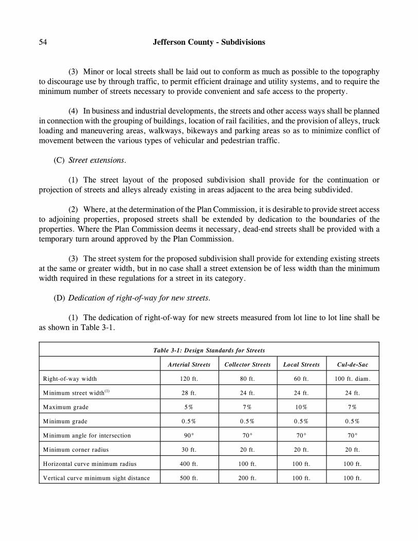
54 Jefferson County - Subdivisions
(3) Minor or local streets shall be laid out to conform as much as possible to the topographyto discourage use by through traffic, to permit efficient drainage and utility systems, and to require theminimum number of streets necessary to provide convenient and safe access to the property.
(4) In business and industrial developments, the streets and other access ways shall be plannedin connection with the grouping of buildings, location of rail facilities, and the provision of alleys, truckloading and maneuvering areas, walkways, bikeways and parking areas so as to minimize conflict ofmovement between the various types of vehicular and pedestrian traffic.
(C) Street extensions.
(1) The street layout of the proposed subdivision shall provide for the continuation orprojection of streets and alleys already existing in areas adjacent to the area being subdivided.
(2) Where, at the determination of the Plan Commission, it is desirable to provide street accessto adjoining properties, proposed streets shall be extended by dedication to the boundaries of theproperties. Where the Plan Commission deems it necessary, dead-end streets shall be provided with atemporary turn around approved by the Plan Commission.
(3) The street system for the proposed subdivision shall provide for extending existing streetsat the same or greater width, but in no case shall a street extension be of less width than the minimumwidth required in these regulations for a street in its category.
(D) Dedication of right-of-way for new streets.
(1) The dedication of right-of-way for new streets measured from lot line to lot line shall beas shown in Table 3-1.
Table 3-1: Design Standards for Streets
Arterial Streets Collector Streets Local Streets Cul-de-Sac
Right-of-way width 120 ft. 80 ft. 60 ft. 100 ft. diam.
Minimum street width 28 ft. 24 ft. 24 ft. 24 ft.(1)
Maximum grade 5% 7% 10% 7%
Minimum grade 0.5% 0.5% 0.5% 0.5%
Minimum angle for intersection 90° 70° 70° 70°
Minimum corner radius 30 ft. 20 ft. 20 ft. 20 ft.
Horizontal curve minimum radius 400 ft. 100 ft. 100 ft. 100 ft.
Vertical curve minimum sight distance 500 ft. 200 ft. 100 ft. 100 ft.
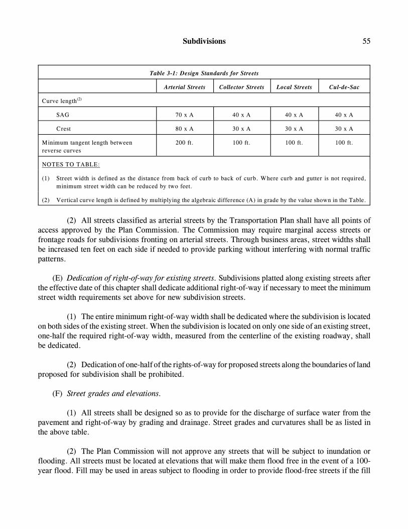
Subdivisions 55
Table 3-1: Design Standards for Streets
Arterial Streets Collector Streets Local Streets Cul-de-Sac
Curve length(2)
SAG 70 x A 40 x A 40 x A 40 x A
Crest 80 x A 30 x A 30 x A 30 x A
Minimum tangent length between
reverse curves
200 ft. 100 ft. 100 ft. 100 ft.
NOTES TO TABLE:
(1) Street width is defined as the distance from back of curb to back of curb. Where curb and gutter is not required,
minimum street width can be reduced by two feet.
(2) Vertical curve length is defined by multiplying the algebraic difference (A) in grade by the value shown in the Table.
(2) All streets classified as arterial streets by the Transportation Plan shall have all points ofaccess approved by the Plan Commission. The Commission may require marginal access streets orfrontage roads for subdivisions fronting on arterial streets. Through business areas, street widths shallbe increased ten feet on each side if needed to provide parking without interfering with normal trafficpatterns.
(E) Dedication of right-of-way for existing streets. Subdivisions platted along existing streets afterthe effective date of this chapter shall dedicate additional right-of-way if necessary to meet the minimumstreet width requirements set above for new subdivision streets.
(1) The entire minimum right-of-way width shall be dedicated where the subdivision is locatedon both sides of the existing street. When the subdivision is located on only one side of an existing street,one-half the required right-of-way width, measured from the centerline of the existing roadway, shallbe dedicated.
(2) Dedication of one-half of the rights-of-way for proposed streets along the boundaries of landproposed for subdivision shall be prohibited.
(F) Street grades and elevations.
(1) All streets shall be designed so as to provide for the discharge of surface water from thepavement and right-of-way by grading and drainage. Street grades and curvatures shall be as listed inthe above table.
(2) The Plan Commission will not approve any streets that will be subject to inundation orflooding. All streets must be located at elevations that will make them flood free in the event of a 100-year flood. Fill may be used in areas subject to flooding in order to provide flood-free streets if the fill
56 Jefferson County - Subdivisions
does not unduly increase flood heights and where allowed by and in accordance with any applicable rulesand regulations of the State Department of Natural Resources. Drainage openings under any streets shallbe designed so as not to restrict the flow of water, thereby unduly increasing flood heights.
(G) Intersections.
(1) In general, all streets shall join each other so that for a distance of at least 100 feet the streetis approximately at right angles to the street it joins.
(2) Intersections shall be designed with a flat grade wherever practical. In hilly or rolling areas,at the approach to an intersection, a leveling area shall be provided having a 2% maximum grade at least60 feet in distance measured from the nearest right-of-way line of the intersecting street.
(3) No lot or other parcel of land which abuts on and has access to either a collector or a localaccess street shall have a service drive, curb cut or other means of access to an arterial street within 50feet of the right-of-way of any street which intersects the arterial street on the side on which the lot orparcel is located.
(H) Gutters and curbs.
(1) Gutters and curbs shall not be required for streets in subdivisions designed for two dwellingunits or less per acre of ground within the boundaries of the plat.
(2) Gutters and curbs shall be required for all streets in subdivisions as designed for more thantwo dwelling units per acre of ground within the boundaries of the plat.
(3) Gutters and curbs may be required in the case of marginal access streets.
(4) Gutters and curbs may be integral concrete curb or combined gutter and curb type and maybe designed with either straight or rolled curb section.
(I) Dead-ends and cul-de-sacs.
(1) Dead end streets shall not be allowed unless specifically approved by the Plan Commission.Where allowed, dead end streets shall not exceed 800 feet in length.
(2) Minor terminal streets or courts (cul-de-sacs) which are designed so as to have one endpermanently closed shall not be longer than 800 feet. The streets shall be provided at the closed end witha turnaround having a radius at the outside of the pavement of at least 40 feet and a radius at the outsideof the right-of-way of at least 50 feet. The cul-de-sac shall be a geometric shape so as to contain an 80-foot diameter minimum circle.
Subdivisions 57
(J) Names.
(1) The proposed name of the subdivision shall not duplicate, or too closely approximatephonetically, the name of any other subdivision in the area covered by these regulations. The PlanCommission shall have final authority to approve the name of the subdivision, which shall be determinedat the time of sketch plan approval.
(2) Street names shall not duplicate any existing name within the area covered by theseregulations, except where a new street is a continuation of an existing street. Street names that may bespelled differently, but sound the same as existing streets shall not be used. The Plan Commission shallcoordinate with 911 services and have final authority to approve the names of streets, which shall bedetermined at the time of sketch plan approval.
(K) Private streets, reserve strips and alleys.
(1) There shall be no private streets or alleys platted within a subdivision.
(2) There shall be no reserve strips in a subdivision except where their control is rested in thecounty under conditions approved by the Plan Commission as authorized in these regulations.
(L) Access to collector streets. Where possible, lots in single-family residential subdivisions frontingon collector streets shall be avoided, and lots at the corners of intersections between local and collectorstreets shall front on the local street and have driveway access to it only and not to the collector street.In multiple-family residential areas, entrances to group parking lots shall have access only to local streets(where possible) and the entrances shall be widely spaced.
(M) Access to principal arterials. Where a subdivision borders on or contains an existing orproposed principal arterial, the Commission may require that access to it be limited by one of thefollowing means.
(1) Design of the subdivision lots so as to have the rear yards adjacent to the principal arterialand frontage onto a parallel local street. No access shall be provided from the principal arterial andscreening shall be provided within a strip of land along the rear property line of the lots.
(2) A series of cul-de-sacs, or loop streets entered from, and designed generally to be at rightangles to, an access street that is at some distance from and parallel to arterial street, with the rear yardsof the terminal lots adjacent to the arterial.
(3) A marginal access or service road (separated from the principal arterial by a landscapedand/or decoratively fenced grass strip and having access thereto at widely spaced suitable points).
(N) Street regulatory signs. A street name sign shall be provided at every street intersection withina subdivision. All necessary stop, speed limit and other traffic control devices and signs shall be
58 Jefferson County - Subdivisions
provided and be in conformance with the Manual on Uniform Traffic Control Devices. The county shallinspect and approve all street signs before issuance of certificates of occupancy for any residence on theapproved streets.
(O) Railroads and limited access highways. Railroads rights-of-way and limited access highwayswhere so located as to affect the subdivision of adjoining lands shall be treated as follows.
(1) In residential districts a buffer strip at least 25 feet in depth in addition to the normal depthof the lot required in the district shall be provided adjacent to the railroad right-of-way or limited accesshighway. This strip shall be part of the platted lots and shall be designated on the plat: “This strip isreserved for screening. The placement of structures hereon other than earth berms, walls, fences andother landscape screening devices approved by the Commission is prohibited.”
(2) In districts zoned for business, commercial or industrial uses, the nearest street extendingparallel or approximately parallel to a railroad shall, wherever practical, be at a sufficient distance therefrom to ensure a suitable depth for commercial or industrial sites.
(3) Streets parallel to a railroad when intersecting a street that crosses the railroad at gradeshall, to the extent practicable, be at a distance of at least 150 feet from the railroad right-of-way. Thedistance shall be determined with due consideration of the minimum distance required for futureseparation of grades by means of appropriate approach gradients.
(P) Construction standards for streets.
(1) Base course for streets and alleys shall have a minimum of 12 inches compacted crushedstone or creek gravel with voids filled by sand or limestone screenings. Subgrade soil conditions shallbe evaluated by the County Engineer. Where drainage and soil conditions warrant, additional depth shallbe required at the discretion of the County Commissioners or the County Engineer. Subgrade shall becompacted to 90% of maximum density for a depth of 12 inches as determined by the proctor needle test.
(2) All hot-mix asphalt pavement shall have 220 pounds per square yard bituminous with 110pounds per square yard bituminous wearing surface. Other type pavements used shall be approved bythe County Commissioners or County Engineers as equivalent to the above-described hot-mix asphalt.(Res. passed 5-5-2004; Ord. 2004-2, passed 5-14-2004; Ord. 2006-3, passed 9-1-2006)
§ 27-3-8 BLOCKS.
(A) Length. Block lengths shall not exceed 1,320 feet or be less than 400 feet, except as the PlanCommission considers necessary to secure efficient use of land or desired features of street layout.Blocks along arterials and collector streets shall not be less than 1,000 feet in length.
Subdivisions 59
(B) Width. Blocks shall be wide enough to allow two tiers of lots of minimum depth. However,where topographical conditions or the size of the property prevent two tiers of lots, the Plan Commissionmay approve a single tier of lots of minimum depth. Double frontage lots, however, should bediscouraged.
(C) Special conditions. In blocks of over 750 feet in length, the Commission may require, at or nearthe middle of the block, a public walk connecting adjacent streets or other public areas. The walks shallbe at least ten feet in width and shall be intended for the use of pedestrians, only.(Res. passed 5-5-2004; Ord. 2004-2, passed 5-14-2004)
§ 27-3-9 COMMUNITY ASSETS.
In all subdivisions, due regard shall be shown for natural features such as large trees, unusual rockformations and water courses; for sites which have historical significance; and for similar assets which,if preserved, will add attractiveness and value to the subdivision and to the community.(Res. passed 5-5-2004; Ord. 2004-2, passed 5-14-2004)
§ 27-3-10 UTILITY EASEMENTS.
All proposed plats submitted for Commission approval under the provision of this chapter shallprovide easements for utilities, drainage and other requirements.
(A) Utility and drainage easements minimum dedication width shall be ten feet front yard, side yardand back yard.
(B) These easements shall accommodate utilities, drainage, including water, electric power, sewer,gas, telephone and fiber optics.
(C) Underground electric lines shall be run to all lots in a subdivision and shall be isolated fromother underground utilities.(Res. passed 5-5-2004; Ord. 2004-2, passed 5-14-2004)
§ 27-3-11 SIDEWALKS.
Sidewalks shall be provided, unless the Plan Commission in its discretion decides they are notnecessary, in all residential subdivisions with a planned density of two or more dwelling units per acre.Sidewalks shall be constructed along both sides of all local streets, collectors and arterial streets.(Res. passed 5-5-2004; Ord. 2004-2, passed 5-14-2004)
60 Jefferson County - Subdivisions
§ 27-3-12 CULVERTS.
(A) Culverts shall be installed wherever necessary to allow for adequate drainage under streets,driveways and other structures.
(B) Use of culverts will be required at all driveways constructed across open drainage ditches.Driveway culverts will be sized as required for the actual drainage flows, but in no case shall be less than12 inches in diameter.(Res. passed 5-5-2004; Ord. 2004-2, passed 5-14-2004)
§ 27-3-13 DRAINAGE AND STORM SEWERS.
(A) General requirements. The Commission shall not recommend for approval any subdivision platwhich does not make adequate provision for storm or flood water runoff channels or basins. The stormwater drainage system shall be separate and independent of any sanitary sewer system. Storm sewers,where required, shall be designed by the rational method, or other methods as approved by theCommission, and a copy of the design computations shall be submitted along with the plans. Inlets shallbe provided so that surface water is not carried across or around any intersection, or for a distance ofmore than 600 feet in the gutter or when the encroachment of storm water into the street disrupts traffic.When calculations indicate that the spread of storm water in the street will disrupt traffic at a point, nofurther allowance shall be made for flow beyond that point, and catch basins or inlets shall be used tointercept flow at that point.
(B) Nature of storm water facilities.
(1) Location. The subdivider may be required by the Commission to carry away by pipe oropen ditch any spring or surface water that may exist, either previously to, or as result of thesubdivision. The drainage facilities shall be located in the street right-of way where feasible, or inperpetual, unobstructed easements of appropriate width.
(2) Accommodation of upstream drainage areas. A culvert or other drainage facility shall ineach case be large enough to accommodate potential runoff from its entire upstream drainage area,whether inside or outside the subdivision. The County Engineer shall approve the necessary size of thefacility as determined by the subdivider, based on the provisions of the required construction standardsand specifications assuming conditions of maximum potential watershed development permitted by theZoning Ordinance.
(3) Drainage design criteria. The subdivider shall size all storm sewers, culverts, ditches andother drainage structures based on runoff from a ten-year storm event using the appropriateintensity/duration curve for the area and a minimum time of concentration of five minutes. The drainagecalculations shall also include the effect of the subdivision on the existing downstream drainage facilities
Subdivisions 61
outside the subdivided area. Where it is determined that runoff incidental to the development of thesubdivision will overload an existing downstream drainage facility during a five-year storm, the PlanCommission shall also require detention facilities adequate to reduce runoff from the proposeddevelopment to the extent that the post development flow is less than of equal to pre-development flow.
(4) Floodway areas. If a subdivision of land is proposed within the flood plain, floodways shallbe preserved and not diminished in capacity by filling or obstruction, except as approved by the StateDepartment of Natural Resources (DNR) in writing. No residential building site may be located withinthe floodway.
(5) Floodway fringe areas. Where a subdivision is proposed within an area of the flood plaindesignated as a floodway fringe, the Commission may approve such subdivision provided that: all streetsare elevated sufficiently to be above the regulatory flood elevation; all lots for residential usage have aflood protection grade two feet above the regulatory flood elevation; where provided, water and sanitarysewer facilities are constructed to eliminate contamination of or by flood water, and, approval to fill thearea from the State Department of Natural Resources has been obtained in writing. Lands below theregulatory flood elevation shall not be used for computing the area requirement for any lot.
(6) Flood plain areas. Where a subdivision is proposed within an area of the flood plain forwhich floodway and floodway fringe designations have not been made, the Commission shall not approvesuch a subdivision unless all streets are raised sufficiently to be above the regulatory flood elevation; alllots for residential usage have a flood protection grade of two feet above the regulatory flood elevation;where provided, public water and sanitary sewer facilities are constructed to eliminate contamination ofor by flood water; and, filling to achieve the above will not raise the level of the regulatory floodelevation more than one-tenth of one foot for that reach of the stream. All filling in the flood plain mustbe approved in writing by the State Department of Natural Resources. Lands below the regulatory floodelevation shall not be used for computing the area requirement for any lot.
(7) Recording of plats in the flood plain and floodway fringe. All final plats having within theirboundaries areas whose elevation is below that of the regulatory flood elevation shall show and label theregulatory flood boundary and elevation, as of the date the final plat is recorded.(Res. passed 5-5-2004; Ord. 2004-2, passed 5-14-2004)
§ 27-3-14 DEDICATION OF DRAINAGE EASEMENTS.
(A) Where topography or other conditions are such as to make impractical the inclusion of drainagefacilities within street rights-of-way, perpetual unobstructed easements at least 15 feet in width for thedrainage facilities shall be provided across property outside the right-of-way lines and with satisfactoryaccess to the street. Easements shall be indicated on the plat. Drainage easements shall be carried fromthe street to a natural watercourse or to other drainage facilities.
62 Jefferson County - Subdivisions
(B) The applicant shall dedicate, either in fee or by drainage or conservation, easement land on bothsides of existing watercourses of a width to be determined by the Commission and, in the case of legaldrains, the County Drainage Board/Board of County Commissioners.(Res. passed 5-5-2004; Ord. 2004-2, passed 5-14-2004)
§ 27-3-15 WATER SUPPLY IMPROVEMENTS.
(A) If a water main from a public water utility is located within 500 feet of a proposed subdivisionand if connection is possible, the subdivision shall be provided with a complete water distribution systemwhich shall adequately serve all lots, which shall include appropriately spaced fire hydrants, and whichshall be properly connected with the public water supply system. Where a public water supply systemis not accessible within 500 feet of the subdivision, the subdivider shall be required to install alternatewater supply facilities approved by the County Board of Health. Where individual lot wells are to beinstalled, lot dimensions shall meet the approval of the County Board of Health. In any case, watersupply facilities shall be installed as required by standards and specifications as approved by the CountyBoard of Health.
(B) Installation of water lines shall meet the standards of State Department of EnvironmentalManagement and the providing utility.
(C) Design of water supply systems shall be in accordance with the construction standards of thewater utility and as recommended by the American Water Works Association Standards.(Res. passed 5-5-2004; Ord. 2004-2, passed 5-14-2004)
§ 27-3-16 SANITARY SEWER IMPROVEMENTS.
(A) The subdivider shall construct a complete sanitary sewer system which shall adequately serveall lots and which shall be properly connected to the public sanitary sewer system. Where a publicsanitary sewer system is not accessible within 500 feet of the subdivision, the subdivider shall have eachlot tested by a state licensed soil scientist and shall report as to whether the soil can adequately supporta septic system and as to the type of system that is required, and shall provide approved septic permitsfrom the state or local Health Department. In any case, sanitary sewer facilities shall be installed inaccordance with plans and specifications as approved by the State Department of EnvironmentalManagement.
(B) No connection draining storm water runoff, including roof drains or basement sumps, shall bemade to a sanitary sewer.
(C) Design of sanitary sewer systems shall be in accordance with the requirements set by the StateDepartment of Environmental Management.
Subdivisions 63
(D) The use of lift stations in the design of the sanitary sewer system shall be avoided whereverpossible and practical. The inclusion of lift stations shall be subject to specific approval of the StateDepartment of Environmental Management.
(E) Whenever a new subdivision will create flows that will exceed the capacity of the existing sewercollection system, the developer should be required to make those improvements necessary in thedownstream portions of the system to insure adequate capacity to handle the proposed flow.
(F) Selected design criteria.
(1) Locations. Sanitary sewers may be located within street or alley rights-of-way if permissionto do so is granted by the Board of Commissioners of the county. When located in easements on privateproperty, access shall be provided to all manholes. Unless specifically approved otherwise, sanitarysewer manholes and utilities shall not be located within drainage ditches, swales or other defineddrainage areas.
(2) Manholes. Manholes shall be installed at the end of each line, at any change in directionand at distances not greater than 400 feet on straight sections of sanitary sewer lines. The use ofcleanouts other than as required on service laterals shall not be allowed.
(3) Laterals. Service laterals shall be provided to each lot proposed by the subdivider. Amanufactured wye connection shall be installed on the mainline sewer for the purpose of connectingservice laterals. The minimum size of service laterals shall be six-inches diameter.
(4) Dedication and acceptance. If the county were to operate a sewer system, any lift station,grinder pump and the like that is to be dedicated to and accepted by the county for the county to takeownership and maintenance shall use manufacturers approved by the county. All other equipmentproposed to be used by the developer must be approved by the county in advance.(Res. passed 5-5-2004; Ord. 2004-2, passed 5-14-2004)
§ 27-3-17 FIRE DEPARTMENT SUBDIVISION REGULATIONS.
(A) Fire apparatus access roads. Fire apparatus access roads may be required for any developmentproject that does not provide adequate access for fire protection from a public street.
(1) Prior to the start of construction of any structure, the developer shall provide fire apparatusaccess roads to within 100 feet of the exterior wall of the structure.
(2) The access roads shall be extended as required in subsection (A)(1), as new constructiondictates.
(B) Access road construction requirements. All fire apparatus access roads shall meet the followingminimum requirements. If the roads are designed for adoption as streets by the county, the roads shallconform to the requirements of these subdivision regulations.
64 Jefferson County - Subdivisions
(C) Minimum standards.
(1) Width. The unobstructed width of a fire apparatus access road shall not be less than 24 feet.
(2) Vertical clearance. Fire apparatus access roads shall have an unobstructed vertical clearanceof not less than 13 feet, six inches, except where a smaller clearance will allow the passage of the tallestpiece of apparatus used by the servicing fire department(s). Requested clearance shall require approvalby the inspecting officer.
(3) Modifications. Vertical clearances and/or widths required by this section shall be increasedwhen, vertical clearances or widths are not adequate to provide fire apparatus access for the largest fireapparatus expected to be used by the servicing fire department(s).
(4) Loads. Fire apparatus access roads shall be designed and constructed to support the imposedloads of the heaviest piece of fire apparatus to be used by the servicing fire departments(s).
(5) Turning radius. Fire apparatus access roads shall be designed and constructed to permitaiming of the longest piece of fire apparatus used by the servicing fire department(s).
(6) Turnarounds. All such roads, which are dead-end roads in excess of 150 feet in length,shall be designed and constructed so as to allow the turning around of the longest piece of fire apparatusused by the servicing fire department(s).
(7) Grade. The gradient of all fire apparatus access roads shall not exceed the maximum thatthe fire apparatus used by the servicing fire department(s) can accommodate.
(D) Fire hydrants, water supply, required flow. If adequate water supply exists, prior to the startof construction of any structure, the Plan Commission may require the developer to provide and install,in a fully working condition sufficient fire hydrants, capable of delivering required waterflow as set outby the requirements of this section.
(1) Required flow. Delivered flow shall meet the requirements of nationally recognizedauthorities, such as the National Fire Protection Association and the like, as well as others recognizedby the inspecting officer. It shall be the responsibility of the developer to perform the required testingin conformance with the recognized standards and provide the inspecting officer with written results.
(2) Hydrant spacing. Spacing shall conform to the requirements of a nationally recognizedauthority, such as the National Fire Protection Association, American Waterworks Association and thelike, but shall not exceed 800 feet.
(3) Connections. In addition to other provided connections, there shall be at least twoconnections of a diameter of two and one-half inches providing for connection to the main intake of fireapparatus pumps as used by the servicing fire department(s). Threads shall be of the type used by theservicing fire department(s).
Subdivisions 65
(4) Installation. Installation shall conform to the requirements of standards of nationallyrecognized authorities, such as the national Fire Protection Association, American WaterworksAssociation, and those of the servicing water department(s).
(E) Adopted standards and documents. The following standards and references are adopted as aguide toward ensuring compliance with the regulations.
(1) NFPA 1231, “Standard on Water Supplies for Suburban and Rural Firefighting”, 1989Edition;
(2) NFPA 1201, “Recommendations for Developing Fire Protection Services for the Public”,1989 Edition;
(3) NFPA 291, “Fire Flow Testing and Marking of Hydrants”, 1988 Edition;
(4) American Waterworks Association, Manual M-17, “Installation, Field Testing, andMaintenance of Fire Hydrants”, 1980 Edition;
(5) NFPA 1963, “Standard for Screw Threads and Gaskets for Fire Hose Connections”, 1985Edition;
(6) Insurance Services Office, “Fire Suppression Rating Schedule”; and
(7) Fire Underwriters Survey, “Water Supply for Public Fire Protection”.
(F) Inspection and enforcement.
(1) It shall be the duty of that person designated as Fire Code Inspector to perform the requiredinspections as necessary in order to evaluate compliance and report the findings to the governing bodyenforcing these regulations.
(2) In the absence of a Fire Code Inspector, the governing body shall appoint a properlyqualified person to perform the duties required herein.
(3) The Inspector shall perform the required duties in cooperation with the heads of otherinvolved agencies.
(4) Where the jurisdiction is empowered to enforce the State Fire Prevention Code, thosesections of these regulations relating to fire protection shall be adopted and incorporated as a section ofthe local Fire Prevention Code, following review and approval of the State Department of Fire andBuilding Services.
66 Jefferson County - Subdivisions
(5) The Building Inspector shall take appropriate and prescribed enforcement action upondetermination that a violation has been committed.(Res. passed 5-5-2004; Ord. 2004-2, passed 5-14-2004)
Article 4: Assurance for Completion of Improvements
§ 27-4-1 COMPLETION OF IMPROVEMENTS.
Before the final plat of any subdivided area shall be approved, signed and recorded, the subdividershall construct all improvements as required by Article 3 of this chapter and in accordance with theapproved preliminary plat and construction plans except as allowed by § 27-4-2. Improvements shallinclude construction of all streets, sidewalks, utilities and grading as required to properly develop thebuilding lots. Improvements shall be performed to the satisfaction of the Commission.(Res. passed 5-5-2004; Ord. 2004-2, passed 5-14-2004)
§ 27-4-2 POSTING OF BONDS.
(A) At the discretion of the Commission, the requirements for completion of improvements asdescribed above may be waived provided that the subdivider shall post a performance bond in an amountequal to 100% of the value of any improvements remaining to be completed. The value of the work shallbe established by the Commission based on a reasonable estimate of construction costs. The bond shallbe securable to the county and is intended to provide reasonable assurance to the county of thesatisfactory construction of the uncompleted portion of the required public improvements. Under theprovisions of accepting a performance bond, the county shall require the applicant to enter into a contractguaranteeing completion of all public improvements within one year of posting of the bond.
(B) In lieu of a performance bond, the applicant may provide the county with a certified check inan amount equal to 100% of the estimated cost of completion of the uncompleted portion of requiredpublic improvements.
(C) In the event of unforeseen circumstances, an additional time period for development beyond theone-year requirement may be negotiated.
(D) A performance bond furnished pursuant to this chapter shall comply with all statutoryrequirements and shall be satisfactory to the County Attorney as to form, sufficiency and manner ofexecution as set forth in this chapter.(Res. passed 5-5-2004; Ord. 2004-2, passed 5-14-2004)
Subdivisions 67
Article 5: Administration
§ 27-5-1 INSPECTION.
(A) When the construction plans have been approved as provided in this chapter, the subdividershall first notify the appropriate agency of their intention to proceed with the construction and installationof improvements. Notification shall be made at lest 48 hours before any construction or installation shallcommence so as to give the appropriate agency an opportunity to inspect the site prior to commencementof work and to inspect installation or construction of the streets and improvements during the course ofwork being performed. In order to defray a part of the costs incurred by the county in inspecting theinstallation of the improvements required by this chapter, the subdivider shall, before he or she proceedswith any construction or installation, present a certified check or money order made payable to thecounty in an amount equal to 1% of the estimate of the cost of improvements; the minimum fee is $50.
(B) The appropriate agency shall have the right to periodically inspect the required improvementsduring construction to ensure their satisfactory completion.
(C) If the appropriate agency finds upon inspection that any of the required improvements have notbeen constructed in accordance with the accepted construction standards and specifications, thesubdivider shall be responsible for removal and replacement of the improvements. Whenever the costof improvements is covered by a performance bond, the subdivider and the bonding company shall beseverally and jointly liable for completing the improvement according to specifications.(Res. passed 5-5-2004; Ord. 2004-2, passed 5-14-2004)
§ 27-5-2 ACCEPTANCE OF CONSTRUCTION.
After streets and improvements have been installed and constructed pursuant to the requirementscontained in this chapter, and in the event that the subdivider desires to have the county accept the streetsor improvements, the subdivider shall notify the Plan Commission that the construction or installationhas been completed, and shall supply the county with a minimum of five copies of the as-built plan onwhich the street or improvement in question has been constructed or installed. The five copies of the planshall show thereon the signatures of all agencies and individuals who have approved the plan and containa notice thereon as to where and when the plan was recorded in the office of the County Recorder. Theportion of street or improvement that the subdivider desires to have the county accept shall be shadedor colored on each of the five copies. The plan shall also clearly designate the number of lineal feet ofthe street or improvement, which the subdivider desires to be accepted by the county.(Res. passed 5-5-2004; Ord. 2004-2, passed 5-14-2004)
68 Jefferson County - Subdivisions
§ 27-5-3 RELEASE OR REDUCTION OF PERFORMANCE BOND.
(A) The Plan Commission shall not recommend to the County Commissioners the acceptance ofproposed dedicated improvements, nor release nor reduce a performance bond, until the PlanCommission has received in writing, certificates of completion by the appropriate agency stating that therequired improvements have been satisfactorily completed and until the subdivider’s surveyor hascertified to the Plan Commission that the layout of all public improvements is in accordance withconstruction plans for the subdivision. The Board of County Commissioners shall thereafter accept theimprovements for dedication in accordance with the established procedure.
(B) Prior to any street or other improvement being accepted by the county as hereinafter provided,the subdivider shall post a maintenance bond and/or other security naming the county as obligee in anamount deemed adequate by the County Engineer to insure maintenance of the improvements for a periodof at least 12 months from the date of acceptance by the county.
(C) The amount of bond may be reduced by the Plan Commission at any time, if recommended bythe County Engineer. No bond shall be reduced below an amount necessary to insure the installation ofremaining improvements and the good repair and proper functioning of all improvements at the timewhen 80% of the lots shown on the record plat have primary structures built on them and appropriatemeasures taken to prevent erosion and siltation. The final surface course of street pavement shall not beconstructed until 80% of the lots shown on the record plat have structures on them.(Res. passed 5-5-2004; Ord. 2004-2, passed 5-14-2004)
§ 27-5-4 ENFORCEMENT OF VIOLATIONS.
(A) The Zoning Enforcement Officer shall enforce these regulations and bring to the attention ofthe Planning Commission any violations or lack of compliance herewith. Then, the Planning Commissionshall make a recommendation to the County Commissioners.
(B) Restraining provisions.
(1) Any land within the participating jurisdictions subdivided in violation of the terms of thischapter after the effective date hereof, is hereby declared to be a common nuisance, which may berestrained, enjoined or abated in any appropriate action or proceeding.
(2) The Commission may institute an injunction suit requesting an individual or governmentalunit be directed to remove a structure erected in violation of this ordinance, or to make the same complywith its terms. If the Commission is successful in its suit, the respondent shall bear the costs of theaction.
(3) The Commission may institute a suit for mandatory injunction requesting an individual orgovernmental unit be directed, where such individual or governmental unit has violated any provisions
Subdivisions 69
of this chapter, to comply with the provisions of this ordinance. If the Commission is successful in itssuit, the respondent shall pay the Commission’s reasonable attorney fees and all costs related to theenforcement of this chapter.
(C) The County Attorney may, in addition to taking whatever ordinance violation action deemednecessary, take steps to civilly enjoin any violation of these regulations.(Res. passed 5-5-2004; Ord. 2004-2, passed 5-14-2004)
§ 27-5-5 PENALTIES.
Any person, firm or corporation who violates any of these regulations shall, upon findings of suchby a court, be subject to a judgment of not more than $2,500 per occurrence per day. Each day aviolation continues shall be considered a separate offense. The landowner, tenant, subdivider, builder,who commits, participates in, assists in or maintains a violation may be found responsible for a separateordinance violation. Nothing herein contained shall prevent the Plan Commission or any other publicofficial or private citizen from taking lawful action as is necessary to restrain or prevent any violationof these regulations.(Res. passed 5-5-2004; Ord. 2004-2, passed 5-14-2004)
§ 27-5-6 REPEAL OF CONFLICTING REGULATIONS, EFFECTIVE DATE ANDENACTMENT.
All other subdivision regulations or parts thereof in conflict with these regulations are herebyrepealed to the extent necessary to give these regulations full force and effect. These regulations shallbecome effective on 6-21-2004.(Res. passed 5-5-2004; Ord. 2004-2, passed 5-14-2004)

70 Jefferson County - Subdivisions
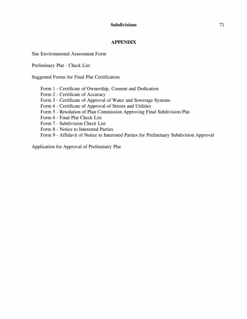
Subdivisions 71
APPENDIX
Site Environmental Assessment Form
Preliminary Plat - Check List
Suggested Forms for Final Plat Certification
Form 1 - Certificate of Ownership, Consent and DedicationForm 2 - Certificate of AccuracyForm 3 - Certificate of Approval of Water and Sewerage SystemsForm 4 - Certificate of Approval of Streets and UtilitiesForm 5 - Resolution of Plan Commission Approving Final Subdivision PlatForm 6 - Final Plat Check ListForm 7 - Subdivision Check ListForm 8 - Notice to Interested PartiesForm 9 - Affidavit of Notice to Interested Parties for Preliminary Subdivision Approval
Application for Approval of Preliminary Plat

72 Jefferson County - Subdivisions

Subdivisions 73
SITE ENVIRONMENTAL ASSESSMENT FORM
...MISSING MATERIAL...

74 Jefferson County - Subdivisions
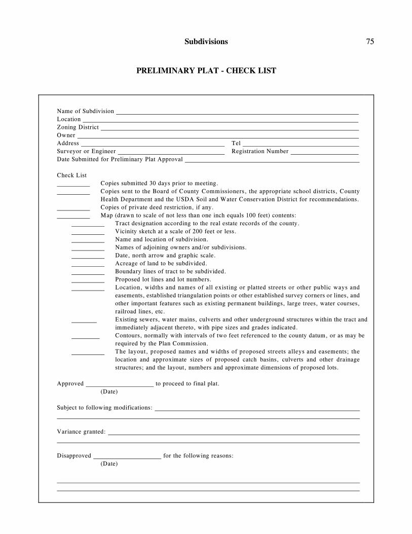
Subdivisions 75
PRELIMINARY PLAT - CHECK LIST
Name of Subdivision
Location
Zoning District
Owner
Address Tel
Surveyor or Engineer Registration Number
Date Submitted for Preliminary Plat Approval
Check List
Copies submitted 30 days prior to meeting.
Copies sent to the Board of County Commissioners, the appropriate school districts, County
Health Department and the USDA Soil and Water Conservation District for recommendations.
Copies of private deed restriction, if any.
Map (drawn to scale of not less than one inch equals 100 feet) contents:
Tract designation according to the real estate records of the county.
Vicinity sketch at a scale of 200 feet or less.
Name and location of subdivision.
Names of adjoining owners and/or subdivisions.
Date, north arrow and graphic scale.
Acreage of land to be subdivided.
Boundary lines of tract to be subdivided.
Proposed lot lines and lot numbers.
Location, widths and names of all existing or platted streets or other public ways and
easements, established triangulation points or other established survey corners or lines, and
other important features such as existing permanent buildings, large trees, water courses,
railroad lines, etc.
Existing sewers, water mains, culverts and other underground structures within the tract and
immediately adjacent thereto, with pipe sizes and grades indicated.
Contours, normally with intervals of two feet referenced to the county datum, or as may be
required by the Plan Commission.
The layout, proposed names and widths of proposed streets alleys and easements; the
location and approximate sizes of proposed catch basins, culverts and other drainage
structures; and the layout, numbers and approximate dimensions of proposed lots.
Approved to proceed to final plat.
(Date)
Subject to following modifications:
Variance granted:
Disapproved for the following reasons:
(Date)

76 Jefferson County - Subdivisions
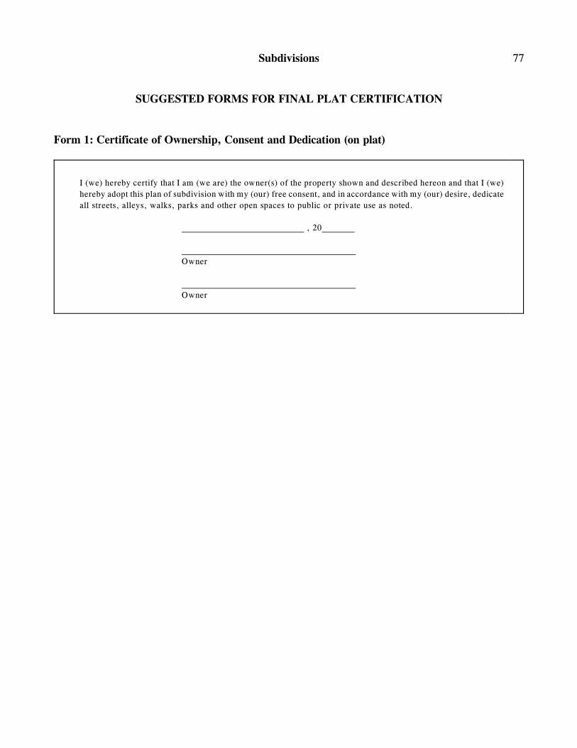
Subdivisions 77
SUGGESTED FORMS FOR FINAL PLAT CERTIFICATION
Form 1: Certificate of Ownership, Consent and Dedication (on plat)
I (we) hereby certify that I am (we are) the owner(s) of the property shown and described hereon and that I (we)
hereby adopt this plan of subdivision with my (our) free consent, and in accordance with my (our) desire, dedicate
all streets, alleys, walks, parks and other open spaces to public or private use as noted.
, 20
Owner
Owner

78 Jefferson County - Subdivisions
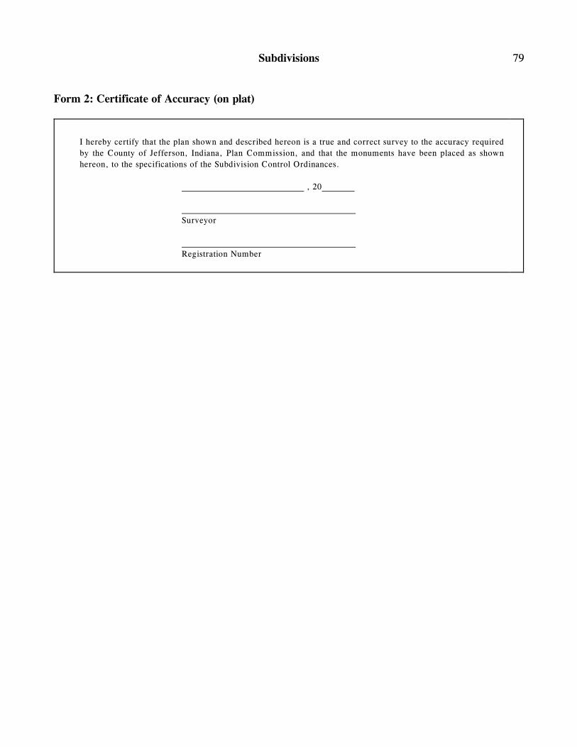
Subdivisions 79
Form 2: Certificate of Accuracy (on plat)
I hereby certify that the plan shown and described hereon is a true and correct survey to the accuracy required
by the County of Jefferson, Indiana, Plan Commission, and that the monuments have been placed as shown
hereon, to the specifications of the Subdivision Control Ordinances.
, 20
Surveyor
Registration Number

80 Jefferson County - Subdivisions
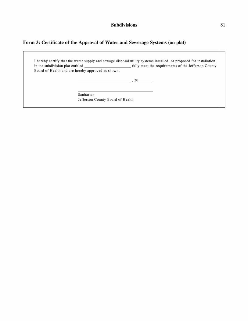
Subdivisions 81
Form 3: Certificate of the Approval of Water and Sewerage Systems (on plat)
I hereby certify that the water supply and sewage disposal utility systems installed, or proposed for installation,
in the subdivision plat entitled fully meet the requirements of the Jefferson County
Board of Health and are hereby approved as shown.
, 20
Sanitarian
Jefferson County Board of Health

82 Jefferson County - Subdivisions
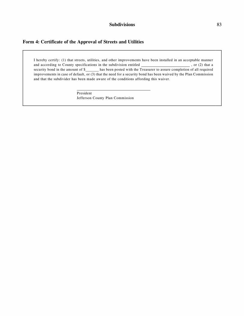
Subdivisions 83
Form 4: Certificate of the Approval of Streets and Utilities
I hereby certify: (1) that streets, utilities, and other improvements have been installed in an acceptable manner
and according to County specifications in the subdivision entitled , or (2) that a
security bond in the amount of $ has been posted with the Treasurer to assure completion of all required
improvements in case of default, or (3) that the need for a security bond has been waived by the Plan Commission
and that the subdivider has been made aware of the conditions affording this waiver.
President
Jefferson County Plan Commission

84 Jefferson County - Subdivisions
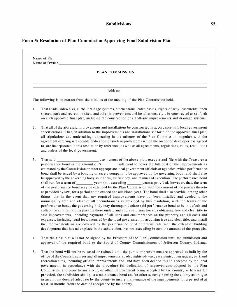
Subdivisions 85
Form 5: Resolution of Plan Commission Approving Final Subdivision Plat
Name of Plat
Name of Owner
PLAN COMMISSION
Address
The following is an extract from the minutes of the meeting of the Plan Commission held.
1. That roads, sidewalks, curbs, drainage systems, storm drains, catch basins, rights-of-way, easements, open
spaces, park and recreation sites, and other improvements and installations, etc., be constructed as set forth
on such approved final plat, including the construction of all off-site improvements and drainage systems.
2. That all of the aforesaid improvements and installations be constructed in accordance with local government
specifications. That, in addition to the improvements and installations set forth on the approved final plat,
all stipulations and undertakings appearing in the minutes of the Plan Commission, together with the
agreement offering irrevocable dedication of such improvements which the owner or developer has agreed
to, are incorporated in this resolution by reference, as well as all agreements, regulations, rules, resolutions
and orders of the local government.
3. That said , as owners of the above plat, execute and file with the Treasurer a
performance bond in the amount of $ sufficient to cover the full cost of the improvements as
estimated by the Commission or other appropriate local government officials or agencies, which performance
bond shall be issued by a bonding or surety company to be approved by the governing body, and shall also
be approved by the governing body as to form, sufficiency, and manner of execution. The performance bond
shall run for a term of years (not exceeding years); provided, however, that, the term
of the performance bond may be extended by the Plan Commission with the consent of the parries thereto
as provided by law, for a period not to exceed one additional year. The bond shall also provide, among other
things, that in the event that any required improvements have not been installed and deeded to the
municipality free and clear of all encumbrances as provided by this resolution, with the terms of the
performance bond, the governing body may thereupon declare said performance bond to be in default and
collect the sum remaining payable there under, and apply said sum towards obtaining free and clear title to
said improvements, including payment of all liens and encumbrances on the property and all costs and
expenses, including legal fees, incurred by the local government in acquiring free and clear title, and install
the improvements as are covered by the performance bond commensurate with the extent of building
development that has taken place in the subdivision, but not exceeding in cost the amount of the proceeds.
4. That the final plat will not be signed by the President of the Plan Commission until the submission and
approval of the required bond to the Board of County Commissioners of Jefferson County, Indiana.
5. That the bond will not be released or reduced until the public improvements are approved as built by the
office of the County Engineer and all improvements, roads, rights-of-way, easements, open spaces, park and
recreation sites, including off-site improvements and land have been deeded to and accepted by the local
government, in accordance with the procedure for dedication of improvements adopted by the Plan
Commission and prior to any street, or other improvement being accepted by the county, as hereinafter
provided, the subdivider shall post a maintenance bond and/or other security naming the county as obligee
in an amount deemed adequate by the county to insure maintenance of the improvements for a period of at
least 18 months from the date of acceptance by the county.
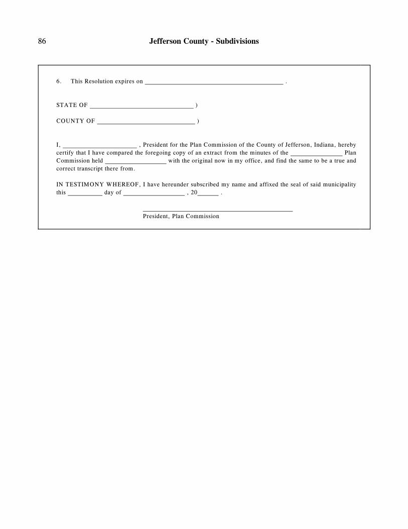
86 Jefferson County - Subdivisions
6. This Resolution expires on .
STATE OF )
COUNTY OF )
I, , President for the Plan Commission of the County of Jefferson, Indiana, hereby
certify that I have compared the foregoing copy of an extract from the minutes of the Plan
Commission held with the original now in my office, and find the same to be a true and
correct transcript there from.
IN TESTIMONY WHEREOF, I have hereunder subscribed my name and affixed the seal of said municipality
this day of , 20 .
President, Plan Commission
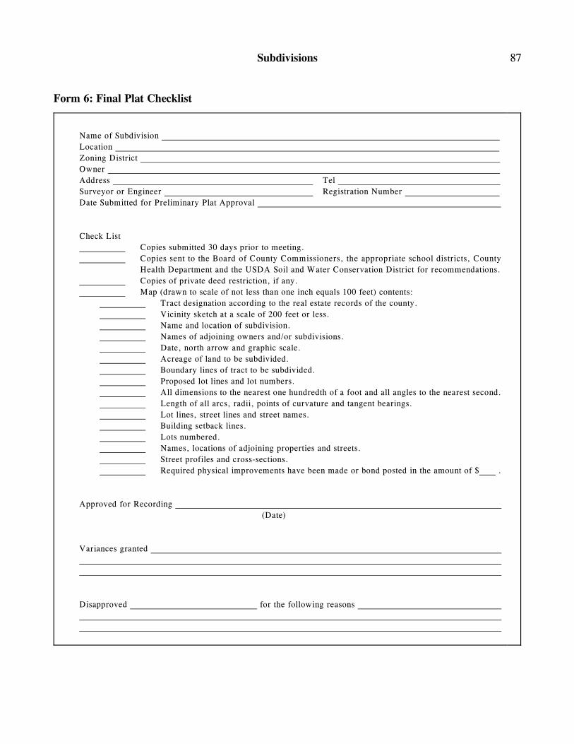
Subdivisions 87
Form 6: Final Plat Checklist
Name of Subdivision
Location
Zoning District
Owner
Address Tel
Surveyor or Engineer Registration Number
Date Submitted for Preliminary Plat Approval
Check List
Copies submitted 30 days prior to meeting.
Copies sent to the Board of County Commissioners, the appropriate school districts, County
Health Department and the USDA Soil and Water Conservation District for recommendations.
Copies of private deed restriction, if any.
Map (drawn to scale of not less than one inch equals 100 feet) contents:
Tract designation according to the real estate records of the county.
Vicinity sketch at a scale of 200 feet or less.
Name and location of subdivision.
Names of adjoining owners and/or subdivisions.
Date, north arrow and graphic scale.
Acreage of land to be subdivided.
Boundary lines of tract to be subdivided.
Proposed lot lines and lot numbers.
All dimensions to the nearest one hundredth of a foot and all angles to the nearest second.
Length of all arcs, radii, points of curvature and tangent bearings.
Lot lines, street lines and street names.
Building setback lines.
Lots numbered.
Names, locations of adjoining properties and streets.
Street profiles and cross-sections.
Required physical improvements have been made or bond posted in the amount of $ .
Approved for Recording
(Date)
Variances granted
Disapproved for the following reasons

88 Jefferson County - Subdivisions
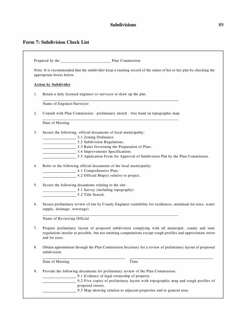
Subdivisions 89
Form 7: Subdivision Check List
Prepared by the Plan Commission
Note: It is recommended that the subdivider keep a running record of the status of his or her plat by checking the
appropriate boxes below.
Action by Subdivider
1. Retain a duly licensed engineer or surveyor to draw up the plat.
Name of Engineer/Surveyor
2. Consult with Plan Commission - preliminary sketch - free hand on topographic map.
Date of Meeting
3. Secure the following, official documents of local municipality:
3.1 Zoning Ordinance.
3.2 Subdivision Regulations.
3.3 Rules Governing the Preparation of Plats.
3.4 Improvements Specifications.
3.5 Application Form for Approval of Subdivision Plat by the Plan Commission.
4. Refer to the following official documents of the local municipality:
4.1 Comprehensive Plan.
4.2 Official Map(s) relative to project.
5. Secure the following documents relating to the site:
5.1 Survey (including topography).
5.2 Title Search.
6. Secure preliminary review of site by County Engineer (suitability for residences, minimum lot sizes, water
supply, drainage, sewerage).
Name of Reviewing Official
7. Prepare preliminary layout of proposed subdivision complying with all municipal, county and state
regulations insofar as possible, but not omitting computations except rough profiles and approximate street
and lot sizes.
8. Obtain appointment through the Plan Commission Secretary for a review of preliminary layout of proposed
subdivision.
Date of Meeting Time
9. Provide the following documents for preliminary review of the Plan Commission:
9.1 Evidence of legal ownership of property.
9.2 Five copies of preliminary layout with topographic map and rough profiles of
proposed streets.
9.3 Map showing relation to adjacent properties and to general area.
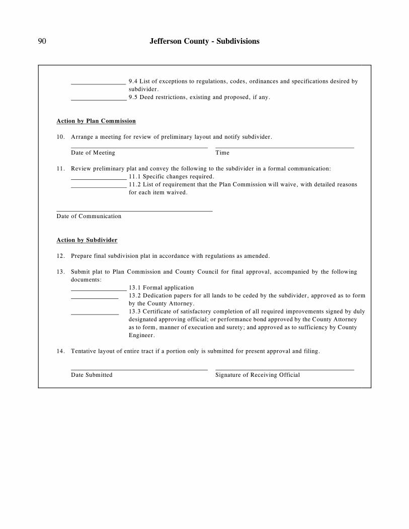
90 Jefferson County - Subdivisions
9.4 List of exceptions to regulations, codes, ordinances and specifications desired by
subdivider.
9.5 Deed restrictions, existing and proposed, if any.
Action by Plan Commission
10. Arrange a meeting for review of preliminary layout and notify subdivider.
Date of Meeting Time
11. Review preliminary plat and convey the following to the subdivider in a formal communication:
11.1 Specific changes required.
11.2 List of requirement that the Plan Commission will waive, with detailed reasons
for each item waived.
Date of Communication
Action by Subdivider
12. Prepare final subdivision plat in accordance with regulations as amended.
13. Submit plat to Plan Commission and County Council for final approval, accompanied by the following
documents:
13.1 Formal application
13.2 Dedication papers for all lands to be ceded by the subdivider, approved as to form
by the County Attorney.
13.3 Certificate of satisfactory completion of all required improvements signed by duly
designated approving official; or performance bond approved by the County Attorney
as to form, manner of execution and surety; and approved as to sufficiency by County
Engineer.
14. Tentative layout of entire tract if a portion only is submitted for present approval and filing.
Date Submitted Signature of Receiving Official
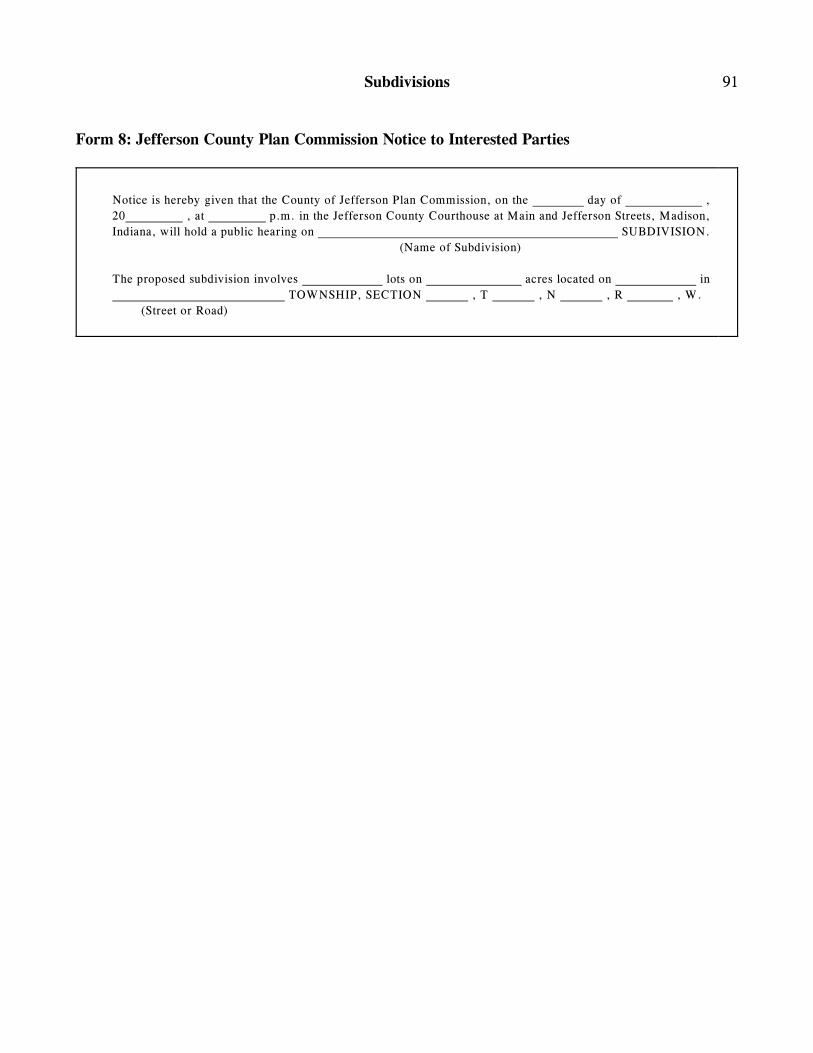
Subdivisions 91
Form 8: Jefferson County Plan Commission Notice to Interested Parties
Notice is hereby given that the County of Jefferson Plan Commission, on the day of ,
20 , at p.m. in the Jefferson County Courthouse at Main and Jefferson Streets, Madison,
Indiana, will hold a public hearing on SUBDIVISION.
(Name of Subdivision)
The proposed subdivision involves lots on acres located on in
TOWNSHIP, SECTION , T , N , R , W.
(Street or Road)

92 Jefferson County - Subdivisions
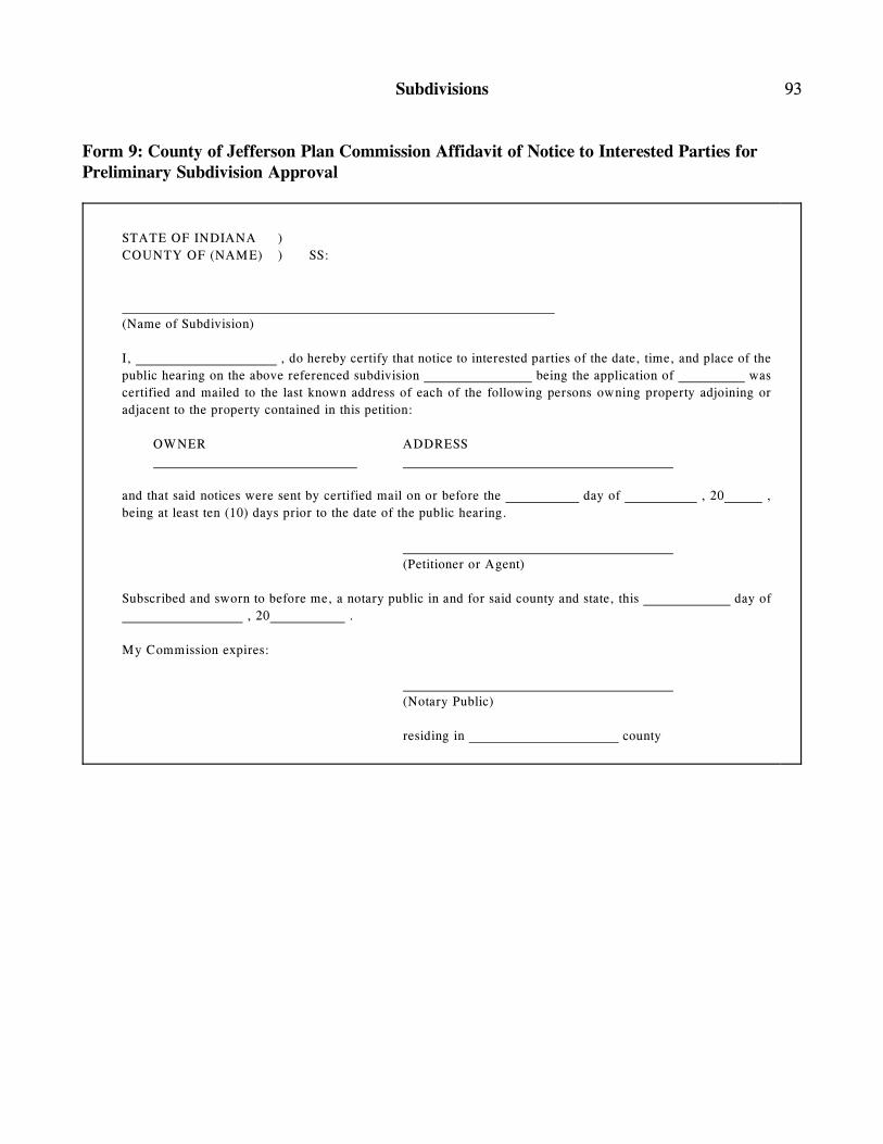
Subdivisions 93
Form 9: County of Jefferson Plan Commission Affidavit of Notice to Interested Parties forPreliminary Subdivision Approval
STATE OF INDIANA )
COUNTY OF (NAME) ) SS:
(Name of Subdivision)
I, , do hereby certify that notice to interested parties of the date, time, and place of the
public hearing on the above referenced subdivision being the application of was
certified and mailed to the last known address of each of the following persons owning property adjoining or
adjacent to the property contained in this petition:
OWNER ADDRESS
and that said notices were sent by certified mail on or before the day of , 20 ,
being at least ten (10) days prior to the date of the public hearing.
(Petitioner or Agent)
Subscribed and sworn to before me, a notary public in and for said county and state, this day of
, 20 .
My Commission expires:
(Notary Public)
residing in county

94 Jefferson County - Subdivisions
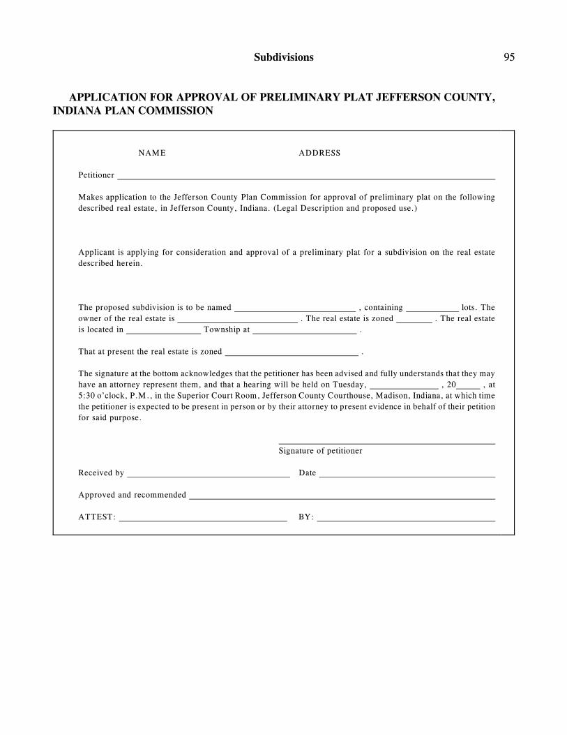
Subdivisions 95
APPLICATION FOR APPROVAL OF PRELIMINARY PLAT JEFFERSON COUNTY, INDIANA PLAN COMMISSION
NAME ADDRESS
Petitioner
Makes application to the Jefferson County Plan Commission for approval of preliminary plat on the following
described real estate, in Jefferson County, Indiana. (Legal Description and proposed use.)
Applicant is applying for consideration and approval of a preliminary plat for a subdivision on the real estate
described herein.
The proposed subdivision is to be named , containing lots. The
owner of the real estate is . The real estate is zoned . The real estate
is located in Township at .
That at present the real estate is zoned .
The signature at the bottom acknowledges that the petitioner has been advised and fully understands that they may
have an attorney represent them, and that a hearing will be held on Tuesday, , 20 , at
5:30 o’clock, P.M., in the Superior Court Room, Jefferson County Courthouse, Madison, Indiana, at which time
the petitioner is expected to be present in person or by their attorney to present evidence in behalf of their petition
for said purpose.
Signature of petitioner
Received by Date
Approved and recommended
ATTEST: BY:

96 Jefferson County - Subdivisions