Embed Size (px)
Citation preview
Chapter Two
Geology of the Trans Himalaya in the
Ladakh sector
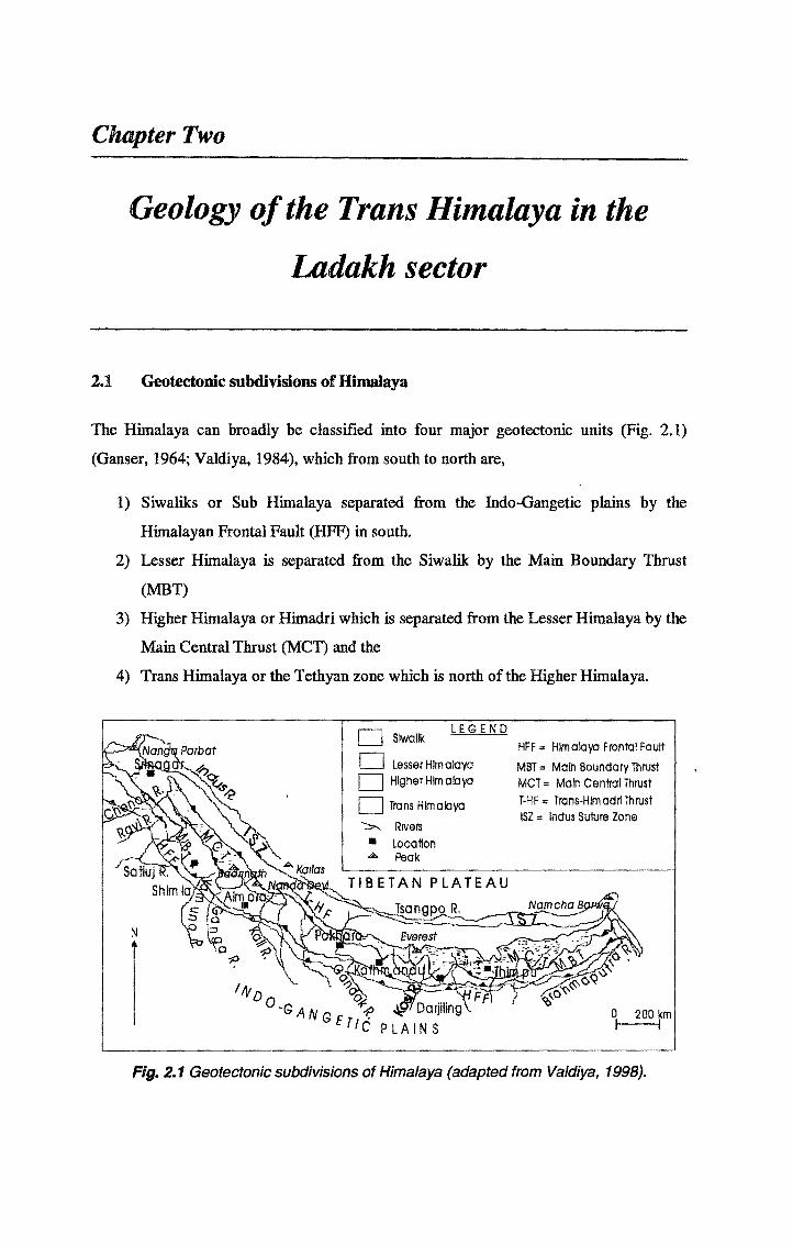
2.1 Geotectonic subdivisions of Himalaya
The Himalaya can broadly be classified into four major geotectonic units (Fig. 2.1)
(Ganser, 1964; Valdiya, 1984), which from south to north are,
1) Siwaliks or Sub Himalaya separated from the Indo-Gangetic plains by the
Himalayan Frontal Fault (HFF) in south.
2) Lesser Himalaya is separated from the Siwalik by the Main Boundary Thrust
(MBT)
3) Higher Himalaya or Himadri which is separated from the Lesser Himalaya by the
Main Central Thrust (MCT) and the
4) Trans Himalaya or the Tethyan zone which is north of the Higher Himalaya.
I-------1 LEGEND| I Slwallk
HFF m Himalaya Frontal FaultI____I Lesser Himalaya
MBT = Main Boundary Thrust| | Higher Himalaya MCT = Main Central Thrust
| | Trans Himalaya
Rivers■ LocationA Peak
T-HF= Trans-HIm adri ThrustISZ = Indus Sulure Zone
Fig. 2.1 Geotectonic subdivisions of Himalaya (adapted from Valdiya, 1998).
Chapter 2 Geology of Cne 1'ratu Hmmlma m the l/tdakh sector
2.2 Subdivisions of Trans Himalaya
The Trans Himalaya, as the name suggests is the terrain lying beyond the main
Himalayan ranges towards the north. The Trans Himalaya again can be subdivided into
following units (Searle et al., 1987), which from south to north are
1) Continental passive margin sediments, (Lahoul supergroup and Zanskar-Spiti
basin sediments in Ladakh) of the northern Indian margin
2) Indus Suture Zone including the arc-trench sediments, ophiolites and continental
molasse deposits,
3) Trans Himalayan Batholith (Ladakh-Gangdese batholith) representing the
subduction related calc-alkaline magmatism and
4) Shyok Suture Zone representing the suturing between the magmatic arc and the
Asian margin.
All the above units of the trans Himalaya can be found in the Ladakh region (Fig. 2.2) of
the northwestern Himalaya
2.3 Geology of Ladakh
2.3.1. General Introduction
Ladakh, the land of many passes, of freezing high barren landscapes in Trans Himalaya
is among the world’s highest inhabited terrains. Situated on the northwestern Trans
Himalaya, Ladakh has three major mountain ranges, Zanskar, Ladakh and Karakoram
range with Higher Himalaya forming its southern border. Being m the rain-shadow
region the annual rainfall is a mere 5 cm here and it is melting snow in summer, which
sustains life. The temperatures go as low as -30°C in Leh and -50°C in Dras. With three
months of subzero temperatures (Dec-Feb) and the rest of the months facing zero degree
temperatures, it is a long and hard winter here. High aridity and low temperatures lead to
sparse vegetation as a result the landscape is desert-like with sand dunes. In summer the
temperature goes above 20°C. In the short intense summer, cultivation is sustained by
melting snow and carefully harnessing the water. Apples, apricots and barley are grown
here in summer. The major waterway of Ladakh is Indus which enters India from Tibet
at Demchok, starting near Mt. Kailash. Its tributaries, the Zanskar, Shmgo, Shyok, and
Nubra and their river valleys form the main area of human habitation. Ladakh also has
9
Chapter 2, Geology of the 'from Himaiaxa in the, Ladakh sector
one of the largest and most beautiful natural lakes in the country Pangong Tso, 150 km
long and 4 km wide, is at the height of 4300 m. Tso Morari, a pearl shaped lake and Tso
kar are the other brackish water lakes of Ladakh Yaye Tso, Kiun Tso and Amtitla are
among the fresh water lakes. Ladakh, covering an area of approximately 98,000 sq km of
the northwest Trans Himalaya provides a complete section through all the major
geological umts of the Trans Himalaya (Fig. 2 2).
2.3.2, The passive continental margin deposits
The passive continental margin deposits are represented by the Paleozoic Lahoul
supergroup and Mesozoic Zanskar supergroup. These are separated by the nft related
Panjal Traps which erupted in Permian and are well exposed now in Kashmir valley.
These are continental tholentes and mildly alkaline flood basalts (Searle et ah, 1987).
With this nft in Permian, the Neo-Tethys passive margin evolved in Mesozoic. This
period is represented by the thick Tnassic platform carbonate and Jurassic transgression
of the shelf marked by the fossiliferous Spiti shales The shallow marine carbonate
deposition continued up to late Cretaceous as represented m the Zanskar ranges and the
Kangi-la flysch is overlying these shallow marine deposits representing the deep water
conditions. The fossiliferous Eocene limestone of the Zanskar is believed to be the
youngest shelf deposit of the Neo-Tethys margin (Mathur and Pant, 1983).
2.3.3. Indus Suture Zone
Indus suture zone contains the deep-sea sediments of the northern Indian plate and
southern Tibetan plate separated by fore arc-trench sediments and overlain by ophiohtic
melanges and molasses (Fig. 2.2). In Ladakh area, the deep sea sediments are represented
by Larnayuru complex which consists of Triassic to Cretaceous shales, sandstones,
turbidites and deep sea radiolarean cherts (Searle et al., 1987 and the references therein).
The Larnayuru complex is believed to represent the deep-sea facies of the Indian passive
margin and are time equivalent of the Zanskar shelf deposits (Mathur and Pant, 1983).
The Larnayuru complex grades into the fore arc Nindam formation. Nindam formation is
mtra oceanic deposits on the southern flank of Dras island arc (Fig. 2.3). It comprises
volcanoclastic sediments and pelagic carbonates. The trace and rare earth element
signatures of sediments are similar to that of Chalt and Dras volcanic rocks but are
distinct
10
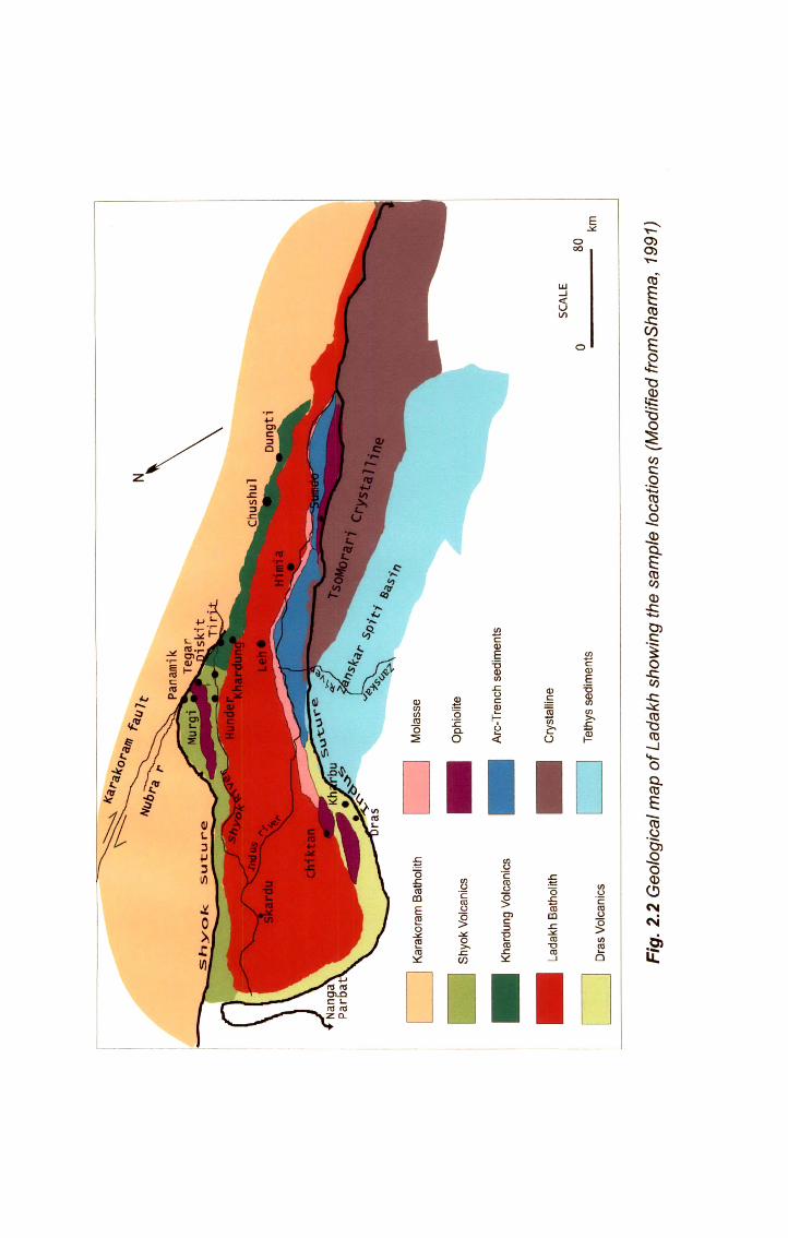
Fig.
2.2 G
eolo
gica
l map
of L
adak
h sh
owin
g th
e sa
mpl
e lo
catio
ns (M
odifi
ed fr
omS
harm
a, 19
91)
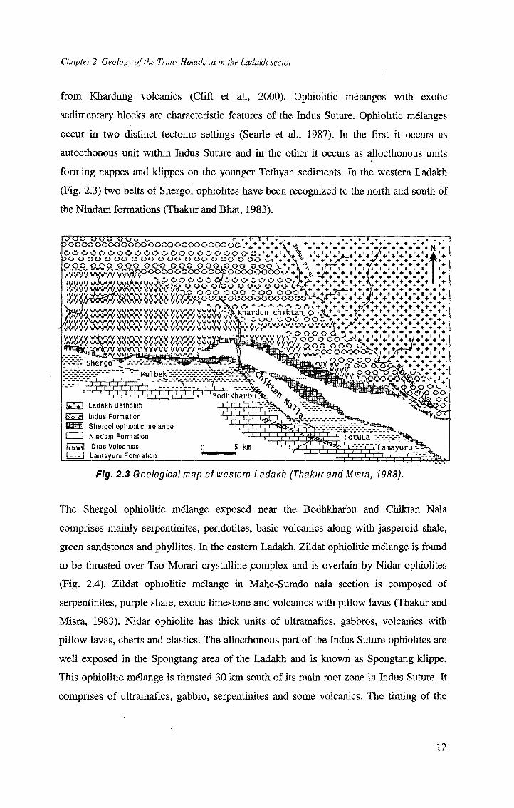
Chaptei 2 Geology of the Turns Himalaya tn the liulakh icctoi
from Khardung volcanics (Clift et al., 2000). Ophiolitic melanges with exotic
sedimentary blocks are characteristic features of the Indus Suture. Ophiolitic melanges
occur in two distinct tectonic settings (Searle et al., 1987). In the first it occurs as
autocthonous unit within Indus Suture and in the other it occurs as allocthonous units
forming nappes and klippes on the younger Tethyan sediments. In the western Ladakh
(Fig. 2.3) two belts of Shergol ophiolites have been recognized to the north and south of
the Nindam formations (Thakur and Bhat, 1983).
6ou "......................... ^ -r + + +'JOOOOOOOOOOOOOOWOOOOOOWyCV+*4 ooosooooosooooosoooooa.v. *OO O (JO O OO O QO O OQ O OO O OO O OO *+ + +OOO OJ$G OOO OOO OOO OOOIOOO oooiv -------------------------1SOOOOOOOOOOOO©OOWOOOOC%
OT ® °o°o?iooo °oJb
. Jhr WWV WWV VWVV WWV VVVV*4^Kl?ard^n"chi ktan°0 WVYWWV VWVV WWV VWVV WVVVVv\^fto(,
?WVV\WVV VWVV VWVV VWVV VWVVVVWv rfoeooooaoocKl VWVV WWV WWV VWVV WWV WWV WWV VV X cfrffloWWV VWVV VWVV VWVV VWVV VWVManaifcwWV WV^OOOO WWV yyyyy yyyyy yyyyy yyyyy vVVVv v v
+ + + + + + + + + + + ++++++++ +/+ +
+ *- + + +
+ + + -f .. ►*.*.*.* N *
fOO
- + + ++ + + + ++ + + ++ + + * + + + + •+ ++ + + + *+ + •■ + + + + + + + ++ + + + ++ ++ +
'+* + * + + 4> + + 4- ‘<,+ ♦+ + + + +♦++ +'+ * +
+ + + + * + + i
+ + + + . -* + + ++ ++ + ♦ + + + + + + ** - * * + + +
£VWV VVVW VWVV VWVV } W VvCkOO OOO'♦ + * *1
1 VVV'pooooooo^x♦ + ♦ + + + + + - + + +
v-»r'shergol j WV" Mul bek >»:
p o o o o <!?&,{? OO C ^ 'wy OOO
t 'X iOOOC
53h^p'rl
trfwvnl
' I ' I ' ' ' I ' ! ' ILadakh Batholith Indus Formation Shergol ophiolitic melange Nindam Formation Dras Volcanics Lamayuru Formation
a_J_BodhKharbu:
TTTL
5 kmS3
_LJ. ECFotuLa
I ;jjji~" • Lamayuru •-=»r t-i
Fig. 2.3 Geological map of western Ladakh (Thakur and Misra, 1983).
The Shergol ophiolitic melange exposed near the Bodhkharbu and Chiktan Nala
comprises mainly serpentinites, peridotites, basic volcanics along with jasperoid shale,
green sandstones and phyllites. In the eastern Ladakh, Zildat ophiolitic melange is found
to be thrusted over Tso Morari crystalline complex and is overlain by Nidar ophiolites
(Fig. 2.4). Zildat ophiolitic melange in Mahe-Sumdo nala section is composed of
serpentinites, purple shale, exotic limestone and volcanics with pillow lavas (Thakur and
Misra, 1983). Nidar ophiolite has thick units of ultramafics, gabbros, volcanics with
pillow lavas, cherts and elastics. The allocthonous part of the Indus Suture ophiolites are
well exposed in the Spongtang area of the Ladakh and is known as Spongtang klippe.
This ophiolitic melange is thrusted 30 km south of its main root zone in Indus Suture. It
comprises of ultramafics, gabbro, serpentinites and some volcanics. The timing of the
12
Chaplet 2 Geology of the Twin Hmiula\a in the Ixidakh sectoi
obduction of the Spongtang ophiolite onto the northern passive margin of the Indian
plate has been debated hotly. Fuchs (1979), Keleman and Sonnenfeld (1983) and Reuber
(1986) suggested a post early Eocene age of the obduction because the Spongtang
ophiolite and its underlying thrust sheets comprising deep water sediments, alkalic
volcanic rocks and melanges have been thrust over Paleocene-Early Eocene limestones.
Searle (1986, 1988) first proposed that the post collisional restacking of the units
obliterated the actual Late-Cretaceous Early Paleocene obduction event. Searle et al.
(1997) presented field data and structural mapping in favor of a Cretaceous obduction.
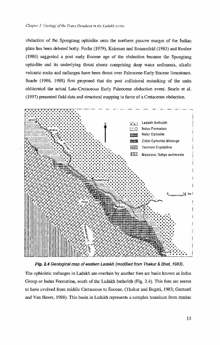
Fig. 2.4 Geological map of eastern Ladakh (modified from Thakur & Bhat, 1983).
The ophiolitic melanges in Ladakh are overlain by another fore arc basin known as Indus
Group or Indus Formation, south of the Ladakh batholith (Fig. 2.4). This fore arc seems
to have evolved from middle Cretaceous to Eocene. (Thakur and Bagati, 1983; Garzanti
and Van Haver, 1988). This basin in Ladakh represents a complex transition from marine
13
Chuptu 2 Geology of the 7)(im Hmiatusa tn th< ladakhseitoi
to continental deposition conditions and thus becomes important to constrain the timing
of initiation of the collision (Rowley, 1996). The transition from marine to continental
deposition starts from the Eocene Indus elastics and Indus molasses overlying the
Numulitic limestone. Hemis conglomerate from near the Hemis gompa south of Leh
representing the continental Molasses has clasts from volcanic, plutonic, sedimentary
and metasedimentary rocks. The major part of the detritus in the Indus group is supplied
from the nearby source and the provenance lies to the north (Thakur and Bagati, 1983).
2.3.4. Ladakh Batholith
Ladakh Batholith is a part of 2500 km long Trans Himalayan Batholith (THB), that is
mainly subduction related calc-alkaline magmatism evolved along the southern margin
of the Eurasian plate in mostly Andean type tectonic setting except in the western sector
of Kohistan batholith where it seems to have intruded into a Chalt-Dras island arc
(Sharma, 1990; Honneger et al., 1982; Weinberg and Dunlop, 2000). Ladakh batholith is
around 500 km long and 30-40 km wide (Fig. 2.2). The rocks range from gabbro norite
to granites and leucogranites. Granodiorites and biotite bearing granites are the
dominating rock types of the Ladakh batholith. At places the different rocks are quite
intermingling and their intrusive relationship is difficult to ascertain (Ahmad et al.,
1998). The Ladakh batholith is cut by andesitic and basaltic dykes.
The existing geochronological data range from 100 Ma to 40 Ma, frequently interpreted
as the duration of subduction. The ending of the magmatism is widely used to constrain
the age of initiation of the collision (Honnegger et al 1982, Weinberg and Dunlop, 2000).
However, younger ages have been obtained recently which probably are post-collision.
The significant crustal anatexis also may be involved in the batholith formation as
indicated by the previous isotopic studies (Honnegger et al., 1982; Weinberg and
Dunlop, 2000).
2.3.5. North of the Ladakh Batholith
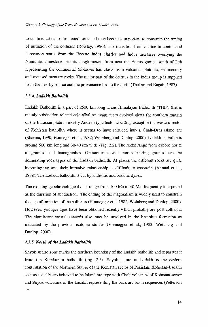
Shyok suture zone marks the northern boundary of the Ladakh batholith and separates it
from the Karakoram batholith (Fig. 2.5). Shyok suture m Ladakh is the eastern
continuation of the Northern Suture of the Kohistan sector of Pakistan. Kohistan-Ladakh
sectors usually are believed to be Island arc type with Chalt volcanics of Kohistan sector
and Shyok volcanics of the Ladakh representing the back arc basin sequences (Petterson
14
Chapte> 2 Geology of the 7rail's Himalaya m the [xukikh sectoi
and Windley, 1985; Upadhyay et al,, 1999). A recent study, however, indicated that the
Northern Kohistan is chemically quite different than the Northern Ladakh. This requires
N
^VVVVV V
dV V V V V V V V ,'pQ°D°oCo V V V V V V V
V V VAn A OOOOOOOOO li ■ « , •'D°°°Wo¥o¥o¥o°o°ot5 i
i v ro rr-h; WoWoWuKuri,1̂ i , J . %AAAAAAAAAl. u immm
./w*'
»KKKKTsKK*
; p'' R u n d a r •.**' > xk <• < > W' N
AN/Hf*/' ViVv /v\ / v ^ I.
’ y<;./v\ vv/^v vW't wi\/,ev,vyi’ K ( ** v v v v v
^EcmKK’'>>v'Vw^C,&v. . . * j;<-y ^ jiffs
□ AlluviumKarakoram Batholith Tint Granitoid Ophiolitic Melange Shyok Volcamcs Saltoro Molasse Saltoro Formation Khardung Volcanics Ladakh Batholith
^L^Kk-.-Diskit ^ k id_Jj- S'
K Ki
^Ki^r * K ^ 1^”'XKKk^ri^KKKKKKKr
;zvv v w* Khalsar.sjvvvvv y —_= nfwvw^MJd j= ,
—L-f-jft I i IS is r\ r\ IS. Is *—IF-TsKKKKKKKK. 1 bsKKKKKKKF
KKKKKKKK.K* , \KKh.-%J|J| ■» i: .. • .::fe^2rXKKKKr^.(sKLKKKt^R^-i =t-v4 *?5>-r ITS*'.. kC K K .KKKKKKK VJ, W . "! !! ■ “I
£*s/*<V'> y>*\.S i-£ yw :.KKKK>^xL.s?XKK. ■ .rsMMMMMM' \ •, .'.v ! I!, ■; '.....-IS,K K, K RK K K \ Alf,,h ^
- *
.KKKKKKR ,.KKKKKKKTv%l!
<*' - *
0 *\.i.. i ^ IS \5 km
„ ,_____, . - ■* x. t
vw <*>>$??' K K' * ’
s-t: KFig. 2.5 Geological map of Shyok Suture Zone in Northern Ladakh (modified from Upadhyay et al., 1999, Rai, 1982).
a different evolutionary scenario of Northern Ladakh than the Northern Kohistan
(Rolland et al., 2000). The relative timing of suturing along the two sutures bounding the
Kohistan-Ladakh sector has remained controversial. While many workers believed
Shyok suture to be older being closed in Cretaceous (Pudsey, 1986; Petterson and
Windley, 1991; Treloar et al., 1996); Brookfield and Reynolds (1981) and Reynolds et
al. (1983) suggested that it did not close until Miocene. Rai (1983), however, argued
15
Chapte> 2 Geology of ike Turns Himalaui m the [julakh sedoi
against any separate suturing along the Shyok suture. According to his interpretation
Indus and Shyok zones are segments of one single suture, which has been cut by the
Ladakh batholith. Shyok suture zone has volcano-sedimentary sequences and melange
zone exposed in Shyok-Nubra valley north of Ladakh batholith. The volcanics range
from basalt to rhyolites and lgmmbrites. Thakur (1981) grouped acidic and explosive
rhyolites and ignimbrites in Khardung volcanics. These directly overlie the Ladakh
batholith. Ophiolitic melanges in Shyok suture zone is exposed in the Nubra valley and
comprises serpentimtes, shales, limestones and basic volcanics. Other volcanic units
grouped under Shyok volcanics range from tholeiitic basalt to basaltic andesites to
andesites. Continental sedimentation in Shyok suture is represented by Saltoro molasses
(Fig. 2.5) and comprises shales, sandstones and conglomerates. Upadhyay et al. (1999)
found it to be in thrust contact with the Shyok volcanics. All major units of Shyok suture
zone are usually described from the Shyok Nubra valley, their characteristics and
relationships are less clear to the east of the Nubra valley (Fig. 2.5). The Shyok suture is
not found to the east of Ladakh. The eastern part appears to have evolved as a pure
Andean type margin.
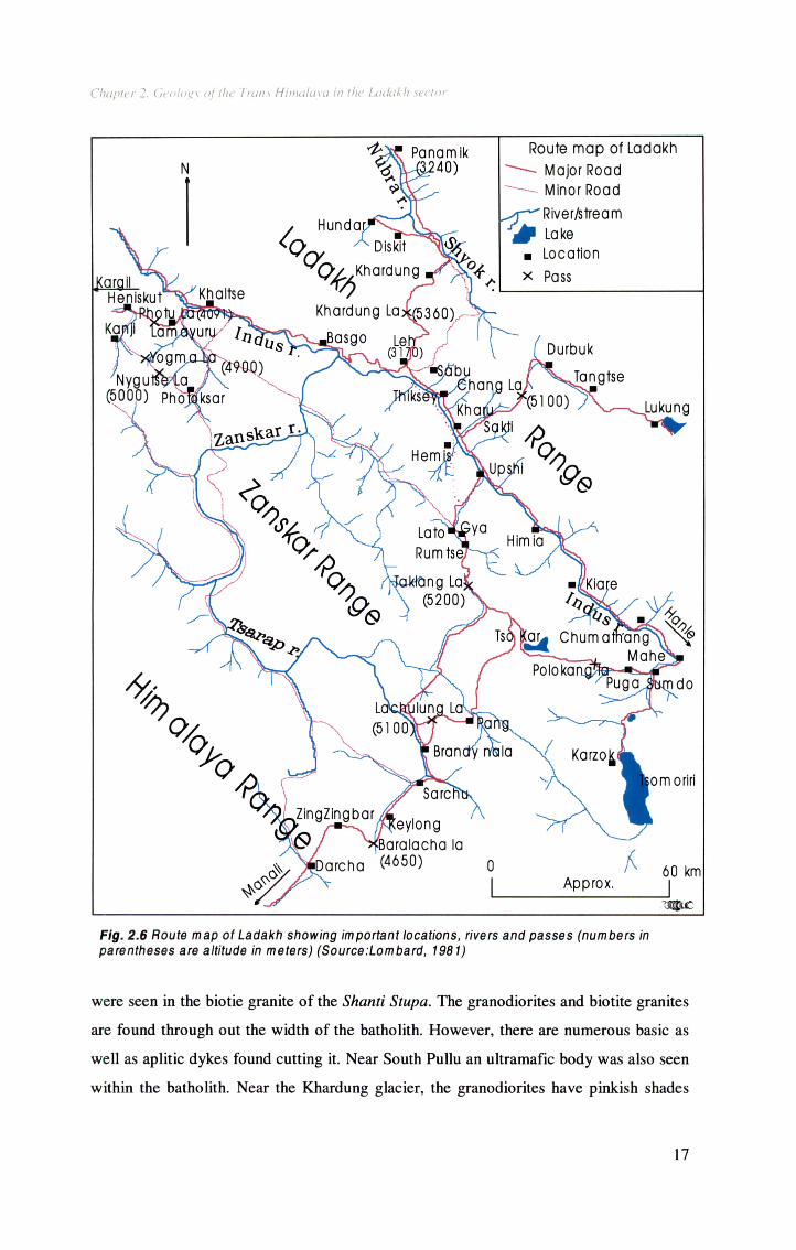
2.4 Fieldwork and samples
Fieldwork in Ladakh, to collect the samples, was carried out in months of August-
September 1997. We traversed through the Lahoul-Spiti and Zanskar basins of
Paleozoic-Mesozoic continental passive margin sediments. We reached Sabu 4 kms
south east of Leh in three days from Manali after crossing four major passes, viz.,
Rohtang pass, Baralacha la (La meaning pass), Lachunglung la, and Tanglang la.
Observations and samples were taken in five major traverses from the main Sabu camp
(Fig. 2.6). Field observations and sample locations are described according to these
traverses. Sample locations and descriptions are tabulated in Table 2 1. The longitudes
and latitudes were obtained by a hand-held GPS (Global Positioning System).
2.4.1. Sabu-Leh-KJhardung la -Khardung-Hunder
This route cuts across the almost NW-SE trending Ladakh ranges of Ladakh batholith
and reaches Nubra-Shyok valley m northern Ladakh. On the southern margin of the
batholith, near Sabu and Leh, the rocks are generally biotite granites with hornblende.
The sample LK 24 was collected from Shanti Stupa m Leh (a Bodh stupa built by the
Japanese). This is a coarse grained biotite hornblende granite. Some more mafic enclaves
16
Chapter 2. Geology of the Trans Himalaya in the Ladakh sector
Fig. 2.6 Route map of Ladakh showing important locations, rivers and passes (numbers in parentheses are attitude in meters) (Source.Lombard, 1981)
were seen in the biotie granite of the Shanti Stupa. The granodiorites and biotite granites
are found through out the width of the batholith. However, there are numerous basic as
well as aplitic dykes found cutting it. Near South Pullu an ultramafic body was also seen
within the batholith. Near the Khardung glacier, the granodiorites have pinkish shades
17

Chapter 2. Geology of the Trans Himalaya in the Ladakh sector
giving them an appearance of monzonite. Acidic volcanics and rhyolites are dominant
rocks towards the base of the batholith and are in tectonic contact with the main batholith
near the Khardung village. Between the Khardung village and the Khalsar traffic
check post (TCP) we found the signatures of the explosive volcanics in the form of
ignimbrites, lapilii textures, tuffs, and volcanic breccias. They form the type locality for
the Khardung volcanics (Fig. 2.7). Rhyolite samples, LK 88 and LK 90, of Khardung
volcanics were collected near the Khardung village towards the Khalsar TCP.
Fig. 2.7 Rhyolite and ignimbrite of Khardung Volcanics near Khardung village in
northern Ladakh
Sample LK86 is taken from further north, between Khalsar and Khardung and is a green
colored volcanics at the contact between acidic Khardung volcanics and Shyok
volcanics. Basic volcanics, at places green colored, grouped under Shyok volcanics are
seen in contact with the acidic volcanics in Hunder Nala and also further north near the
villages Scampuk and Partapur. A traverse along Nubra river was taken to observe and
collect the samples from the various units of the Shyok suture zone.
18
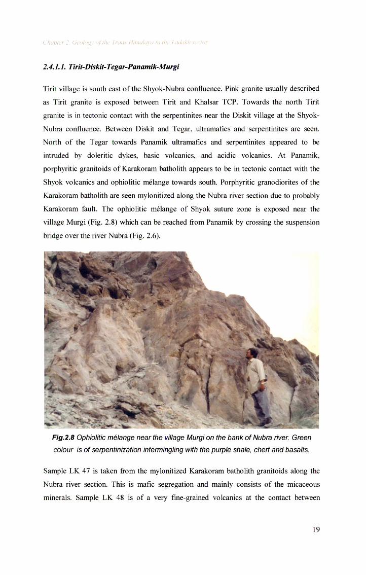
2.4.1.1. Tirit-Diskit-Tegar-Panamik-Murgi
Tirit village is south east of the Shyok-Nubra confluence. Pink granite usually described
as Tirit granite is exposed between Tirit and Khalsar TCP. Towards the north Tirit
granite is in tectonic contact with the serpentinites near the Diskit village at the Shyok-
Nubra confluence. Between Diskit and Tegar, ultramafics and serpentinites are seen.
North of the Tegar towards Panamik ultramafics and serpentinites appeared to be
intruded by doleritic dykes, basic volcanics, and acidic volcanics. At Panamik,
porphyritic granitoids of Karakoram batholith appears to be in tectonic contact with the
Shyok volcanics and ophiolitic melange towards south. Porphyritic granodiorites of the
Karakoram batholith are seen mylonitized along the Nubra river section due to probably
Karakoram fault. The ophiolitic melange of Shyok suture zone is exposed near the
village Murgi (Fig. 2.8) which can be reached from Panamik by crossing the suspension
bridge over the river Nubra (Fig. 2.6).
Chapter 2. Geology of the Irons Himalaya in the Ladakh sector
Fig.2.8 Ophiolitic melange near the village Murgi on the bank of Nubra river. Green
colour is of serpentinization intermingling with the purple shale, chert and basalts.
Sample LK 47 is taken from the mylonitized Karakoram batholith granitoids along the
Nubra river section. This is mafic segregation and mainly consists of the micaceous
minerals. Sample LK 48 is of a very fine-grained volcanics at the contact between
19
Karakoram fault related mylonitized granitoids and the Murgi melange. LK 57 is
medium grained basic volcanics 15 km north of Sumur towards Panamik. Samples LK67
and LK 68 are taken from a sharp contact between basic and acidic volcanics between
Tegar and Panamik about 7 km south of Panamik. Sample LK 70 is a medium grained
basic volcanics collected from between Panamik and Tegar.
2.4.2. Kharu-Sakti-Chnag la- Darbuk-Tangtse-Lukung (Pangong Tso)
This route cuts across the Ladakh batholith, and crosses the Ladakh ranges at Chang la.
Near Sakti village, gabbroic and granitic bodies are intercalated with each other. 11 km
from Sakti towards Chang la (Fig. 2.6), a large body of fine-grained black colored mafic
rock is found as an enclave within the granite. Further north near Chang la, acidic dykes
cutting the gabbros are found. The area north-east of the Chang la, from near Darbuk to
Lukung, seems to have undergone large scale and wide spread deformation with
migmatisation very clearly exposed between Tangtse and Lukung. Serpentinized and
brecciated rocks are found near Tangtse while the mylonitization of granitoids with
elongated phenocrysts of feldspars are seen near the Tangtse Indo-Tibet border police
post, indicative of the widespread deformation, which could be related to the suturing
along the Shyok Suture.
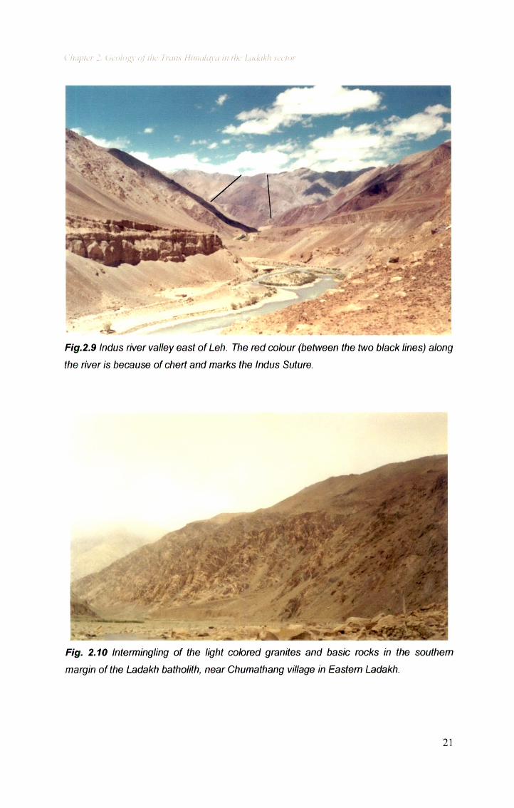
2.4.3. Shey-Thiksey-Upshi-Himia-Gaik-Kiari-Chumathang
This route runs parallel to the Indus river (Fig. 2.9) along the southern margin of the
Ladakh bathoith. Near Thiksey Gompa Gabbro is the main phase of the bathoith, while
near Upshi the pink granite with big crystals of K-feldspar dominates. Between Likche
and Himia Muscovite-Biotite leucogranite, with some hornblende as well, appears to
have intruded in the pre-existing granodiorites. Sample LK 198, of these two-mica
bearing leucogranites is taken from near the Himia village. Near Gaik porphyritic granite
with big phenocrysts of the K-feldspar grains is exposed. Near Kiari, the granodiorites
are richer in hornblende and forms the quartz-monzodiorites. The exposed southern
margin of Ladakh bathoith is most spectacular near Chumathang where leucocratic
granites criss-cross the gabbro and diorite (Fig. 2.10).
20
Chapier 2. Geology of I he Trans Himalaya in the Ladakh sector
Fig.2.9 Indus river valley east of Leh. The red colour (between the two black lines) along
the river is because of chert and marks the Indus Suture.
Fig. 2.10 Intermingling of the light colored granites and basic rocks in the southern
margin of the Ladakh batholith, near Chumathang village in Eastern Ladakh.
21
Chapter 2. Geology of the Trans Himalaya in the Ladakh sector
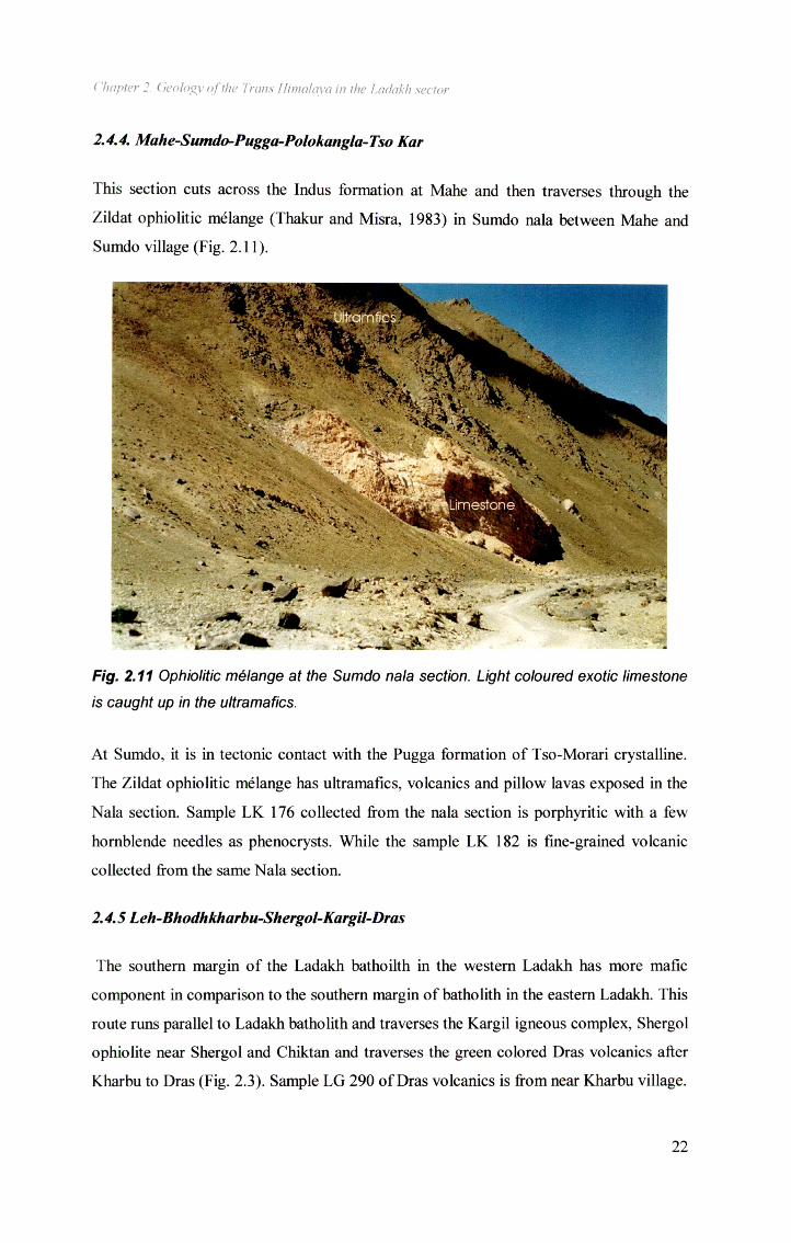
2.4.4. Mahe-Sumdo-Pugga-Polokangla-Tso Kar
This section cuts across the Indus formation at Mahe and then traverses through the
Zildat ophiolitic melange (Thakur and Misra, 1983) in Sumdo nala between Mahe and
Sumdo village (Fig. 2.11).
Fig. 2.11 Ophiolitic melange at the Sumdo nala section. Light coloured exotic limestone
is caught up in the ultramafics.
At Sumdo, it is in tectonic contact with the Pugga formation of Tso-Morari crystalline.
The Zildat ophiolitic melange has ultramafics, volcanics and pillow lavas exposed in the
Nala section. Sample LK 176 collected from the nala section is porphyritic with a few
hornblende needles as phenocrysts. While the sample LK 182 is fine-grained volcanic
collected from the same Nala section.
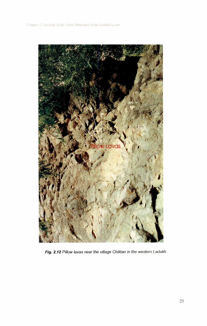
2.4.5 Leh-Bhodhkharbu-Shergol-Kargil-Dras
The southern margin of the Ladakh bathoilth in the western Ladakh has more mafic
component in comparison to the southern margin of batholith in the eastern Ladakh. This
route runs parallel to Ladakh batholith and traverses the Kargil igneous complex, Shergol
ophiolite near Shergol and Chiktan and traverses the green colored Dras volcanics after
Kharbu to Dras (Fig. 2.3). Sample LG 290 of Dras volcanics is from near Kharbu village.
22
Chapter 2. Geology of the Trans Himalaya in the Ladakh sector
Fig. 2.12 Pillow lavas near the village Chiktan in the western Ladakh
23
Chapter 2. Geology of the Trans Himalaya in the Ladakh sector
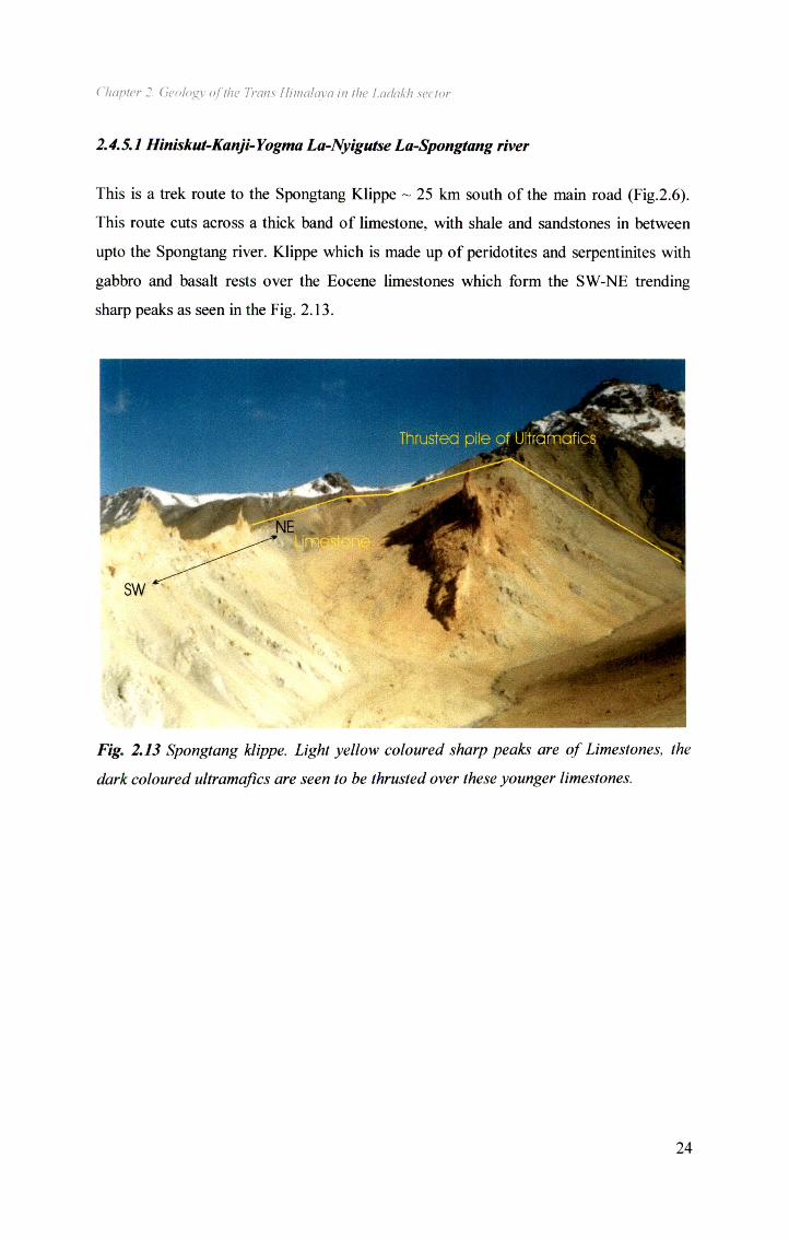
2.4.5.1 Hiniskut-Kanji-Yogma La-Nyigutse La-Spongtang river
This is a trek route to the Spongtang Klippe ~ 25 km south of the main road (Fig.2.6).
This route cuts across a thick band of limestone, with shale and sandstones in between
upto the Spongtang river. Klippe which is made up of peridotites and serpentinites with
gabbro and basalt rests over the Eocene limestones which form the SW-NE trending
sharp peaks as seen in the Fig. 2.13.
Fig. 2.13 Spongtang klippe. Light yellow coloured sharp peaks are of Limestones, the
dark coloured ultramaftcs are seen to be thrusted over these younger limestones.
24
Cluipte1 2 Geology of the Turns Himuta\a m tin ijtdukh sccloi
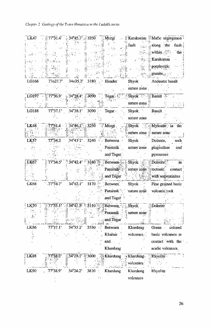
Table 2.1 Location and description of samples I Sample.]. -Location <*. ■'~j‘ Tectonic IP Description - ~j
, -1, setting : • !
Longitude Latitude Altitude Village(°E) (°N) (m) " name -
I , ±100 m •|
LK19,8” _ jj78^13“33.0m2T ;[3870^ j;fiania ' ” 'jLadakh'pp! doarse P ^grainedp' t^5j|'batholith .jmuscovite, biotite
. : , P :. and . hornblende i:Vi- -
.Mi
i'jf
•i-'iL j j bearing ’ F granite -?iiIfleucogranite-; P?!
LK198- 78°5.1’ 33°29.2’ . 3870 ; Himia
Muscovite - - r •
Ladakh ‘ Hand picked
batholith - >95% ' white
muscovite of ~1. ’ mm'.
XK24 77°34.5’ r34°10.4’ jr363.0 rX Leh ij Ladakh J j j Coarse^'p grained
batholith j ‘ biotite granite
--LK24-
Biotite
' LK182' ‘ j[ 77°36.9’ pp33015'.3p
* '4?t yi* t -
3630 \ Leh. \ Ladakh Hand- : picked
*; , ^ * "" batholith >99% . - biotite
grabs of~l mm -
4200
“ » -
.. < Between^!* fj | Indus • ;i *
h Sumdbv and; suture zoneMahe\ " 1 .. . 4r'■
iBasalt .from> * ■* - -- - 'l ophiolidc, ;
; melange
4210 ; Between , , Indus' r Basalt p ‘ from
Sumdo and' suture zone ophiolitic- • Mahe . \ .melange with
LK209 "H 76°3L7’ ,{■34^5^* mpo :L';;Chiktan LI*'Indus ___I - >1 suture zone;-*!
small phenocrysts
ofpyroxenes
■! > Pillow lava'
t -v' r -
Belonging to .-"I ' V ; ;;. J Shergol ophiohte ?J
LG290 Dras Dras Green , colored
volcamcs basic volcamc
rock.
25
Chaplei 2 Geology of the ham Himalaya m the l adakh sectoi
LK47 7 {[ 77°3i.4’' ;.',34°|5.7V?i! 3250” '^fMwgi ([Karakoram IrMafic* segregation'
t5 v1 ■\l
II '
j -,
4-’ |f '-t fault p along ;the fault ]
|}witMn.7,'r' "the *
;j [ Karakoram
i J.il, J t
* porphyritic 7I•granite.i. - i
LG166 lloll.T 34o35.2* 3180 , * Hunder Shyok Andesitic basalt
.suture zone
, LG197? s
“IptSe.?; ; , 34°3f|411 [3090 - ! Tegar,- f; ‘,* - Jr 7 *■ !\ *
jShydk'TTT Basalt 7'' .
l : -]j\ • ' ' p; ..." j; " 4;
4:J, . * ‘t '_iij; suture zone. l .-7. .a.'vM
LG188 77°37..F > 34°38.r 3090 <1 Tegar • Shyok. Basalt
’ 7. ' suture zone‘ LK48.v s«, ~~K
• j 77°31.4 - r34°46,JLJ;^3250 '-j*Murgi. j i Shyok. yj Mylonite in thelifei: Jj -7
l suture zoner_ _ _
i suture zone * ]
LK57 , 77°34.2 ,34°437\ 3240 ‘Between - Shyok Dolente, with, Panamik , suture zone plagioclase and
and Tegar,'. pyroxenes
LK67 ]! 77°34.5’" !l 34042.4" ir3180!| 1 Between^* l-Shyok :;X,-ji ; ff-U . . ,3£; ]jr • . x ,Papami^S*j!suturezdne'
.-ji jiandTepr 7 .• :
! Dolerite' in[tectonic, contacti , ' ;!withserpentinites j
-LK68 77°34.7’ 34°42.r 3170 ’ Between! Shyok ’ Fine pained basic
... ...” Panamik'* ’suturezone volcanicrock
^ LK70
LK86
■> and Tegar ! 1 - ‘ *
77^FT|p4WSn; 3H61|7ptween?^|'BhyQk '"" jjpolaSr” "Ji 7;’ f' || / ' 1/ *s» . 7'"j; Panamik'..••!! suturfe zbne’•!' ' ' -
in • ,iahdTegar *' * li
LK88
LK90
'77°37.r 34°35.2’ 3550 7" Between . Khardung' Green ■ ’ colored
- - , Khalsar volcamcs. basic voleames m
' and. contact with the
Khardung • acidic volcamcs.
:Tm& j!34a297’-jF36()0 fJlKhardung ’rKhardung^RhyolitS'H7*liT‘;f- ir - ---T::; voleanics; 4 '". -
. 77°38.9’ 34°24.2’ 3810 Khardung Khardung Rhyolite
••: volcamcs
26
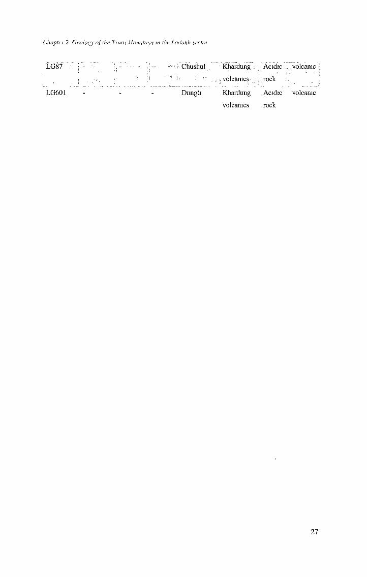
Chapin 2 Geoloyy of ihe Tiani Hihiat/ua in the ladakh scctoi
LG87 j"- ”'r i;-- Chushul ' Khardung ^ Acidic .volcanic
! . j- ; ■ • •• 1 - . , j voleames j;rock~ f
LG601 Dungti Khardung Acidic volcanic
voleames rock
27
![Rachmaninov 3rd Piano Concerto [First Movement] · PDF file53-g e5 = 5 !5 = 5 5 5 5 5 4 5 5 =5 5 = 5e5 5 5 5 5 5 5 5e5 5 5!55 5 5 5 5 5e5 5 5 5 5 5 5! 5 $3e55 5 5: 5 5 5 55 5e 55 5](https://img.pdfslide.us/doc/110x75/5a78944a7f8b9a1f128d15db/rachmaninov-3rd-piano-concerto-first-movement-53-g-e5-5-5-5-5-5-5-5-4-5.jpg)


![Example 11.21 Analyzing Classical Form third movement, 9–23 · Adagio molto G [Main Theme] 55 5 5555 55555 5 = f 5k$ 55 5!5 55 5!55M 3: p 55 $ 5555 = f. Title: example11-21 Author:](https://img.pdfslide.us/doc/110x75/6014233909245c4fac76d57b/example-1121-analyzing-classical-form-third-movement-9a23-adagio-molto-g-main.jpg)