Embed Size (px)
Citation preview


101The economical ForetrexTM 101 is the wrist-mount GPS that frees up your
hands so you can focus on your outdoor activities. This product joins the
Foretrex 201 in Garmin’s growing line of wearable, wrist navigation devices.
The Foretrex 101 has all the features and functionality of the Foretrex 201,
including PC interface capabilities for downloading waypoints, tracks and
routes, but operates on two AAA batteries.
Its easy-to-use interface and basic GPS capabilities are perfect for out-
door enthusiasts who would rather replace the batteries than recharge
the unit in the fi eld. This unit features Garmin’s intuitive operating logic,
utilizing six dedicated buttons to simplify navigation. Whether it’s a
campsite, or other place of interest, users can mark its location, identify
the waypoint, and navigate to it later using the ‘GoTo’ function. Also, with
the help of Garmin’s exclusive TracBack technology, users can retrace their
steps by following an electronic breadcrumb trail back to their original
starting point.
Because the unit is waterproof, the Foretrex 101 is a natural companion
on watersport adventures like kayaking, canoeing, boating and sailing. In
fact, this device incorporates another feature found on the Foretrex 201: a
sailboat-racing timer. Competitors can confi gure the countdown sequence
prior to the start of the race and utilize their GPS location to be in the best
possible tacking position when the race begins.
201The ForetrexTM 201 is a wearable personal navigator, perfect for outdoor and
marine enthusiasts who desire hands-free GPS navigation in a lightweight,
affordable package. At a mere 78 grams, this waterproof wonder is lighter
than most watches, and its wrist-top mount frees up hands for outdoor
activities. Sporting an ergonomic wristband, the Foretrex 201 is similar in
design to the Forerunner 201, yet is chocked full of GPS navigation features
found in Garmin’s popular GekoTM 201 unit.
With a user-friendly interface, the rugged Foretrex 201 simplifi es navigation,
making it ideal for the back country or water. Its six dedicated buttons (GoTo,
Page, Enter/Mark, Up, Down and Power) make it easy to operate. It offers the
most essential navigation data — enhanced GPS accuracy, extensive storage
for waypoints, and reversible routes and tracks — on an easy-to-read display.
Don’t worry about packing extra batteries, because the Foretrex 201 runs on
an internal lithium battery for 15 hours (typical use). Simply recharge and go.
The Foretrex 201 also comes equipped with special features sure to please
mariners and hikers alike. It includes a unique application for sailing and
paragliding racers that allows them to confi gure the start sequence of a race.
The countdown is displayed in a large-number format that audibly alerts the
user at each phase of the start sequence. With the help of Garmin’s exclusive
TracBack® technology, hikers can mark a campsite, go trekking all day, and
follow the electronic ‘breadcrumb trail’ back to camp in time for dinner.
f o r e t r e x

g e k o
With its sun-yellow case, the economical GekoTM 101 is perfect for navigational novices. Features such as one-touch waypoint marking make it a snap to use. Easily maneuver from one waypoint to the next using its 250 way-point storage capacity with symbols, and pan along your track with PanTrack.
250 Waypoints with names and icons
Easy operation with fi ve buttons for one hand use
3,000 trackpoints (101)
25 map datums
GPS accuracy: 15 metres, 95% typical
Built-in patch antenna
Weight: only 88 g with batteries
Compact size: 48 x 99 x 24 mm
High-contrast display: 64 x 100 pixels
2 AAA batteries (not included)
Waterproof to IEC529 IPX7 standards
With Its distinctive canopy-green case, the powerful GekoTM 201 allows more waypoint and route storage, as well as available PC and external power connectivity, In addition, the Geko 201 boasts a user-confi gurable trip com-puter, 10,000 trackpoints, a new upcoming-turn feature, as well as PanTrack and TracBack. Also includes 4 fun, interactive games.
Up to 12 hours battery life
Easy fi ve buttons for one-hand use
PC connectivity and external power
10,000 trackpoints
PanTrack and TracBack
The GekoTM 301 packs an amazing amount of functions into its slim frame. It has all the features of the Geko 201, plus an electroniccompass and a barometric altimeter. The compass provides bearing information while you’re standing still, and the altimeter determines your precise altitude and provides a 12 hour pressure-trend tool for gauging changing weather conditions. The Geko 301 also includes fi ve interactive games that trans-form the great outdoors into a virtual board game, including the new Gekoids, which takes advantage of the electronic compass.
Built-in electronic compass Barometric altimeter for elevation
and weather pressure measurement Weighs only 88 g (with batteries) 500/20 waypoint/route storage 10,000 trackpoints and 10 saved
tracks available
Slim, lightweight and so simple to use - you’ll want a
Geko™ along on every outdoor adventure! These rugged
waterproof GPS receivers weigh in at just over 88 g.
The Geko 101 is a basic navigator that lets you mark
locations and navigate to points. It’s suited for even
101
201
f o r e t r e x
301
the youngest adventure enthusiast. The 201 adds more
options for storing waypoints, routes and tracks. When
it’s time for fun, check out the 201’s built in GPS games,
which are played outdoors with you as the main game
feature. Geko - get it to go.

The eTrex® provides satellite navigation you can count on, pure and simple. A 12-channel GPS locks onto satellites fast and stays locked on, even under extreme conditions. A built-in antenna allows this sleek unit to slip into your hand, pack or pocket with ease. Operations are equally easy and logical. The eTrex is proof that GPS doesn’t have to be diffi cult.
22 Hours battery life Transferable waypoints,
routes and tracks betweenPC and GPS.
1536 Track Points
With eTrex® Camo from Garmin by your side, you can get involved in the thrill of the hunt without look-ing back. Because when it’s time to return to your vehicle or fi nd a tree stand, eTex Camo will take you there. The eTrex Camo includes a built-in database which recom-mends the best times to Hunt and Fish at any given waypoint. And thanks to its camoufl age casing, you can keep eTrex Camo by your side without giving away your location.
22 Hours battery life Transferable waypoints,
routes and tracks between PC and GPS.
2000 Track Points
Wherever your adventures take you, this compact GPS with high resolution screen is ready to go. eTrex® Venture is just the thing for hiking, camping and fi shing. The Venture has a built-in worldwide city point database, and it comes with a PC cable to download waypoints and routes from MapSource® CD-ROMs. Theinnovative four-way cursor allows for smooth map panning. Just select your destination, and eTrex® Venture will guide you there.
20 Hours battery life City point database Transferable waypoints,
routes and tracks between PC and GPS.
2048 Track Points
eTrex® Legend is one of the smallest GPS units you’ll fi nd with built-in motorway and road detail. This versatile navigator is at home on you dash or in your hand as you hike new trails. The Legend accepts downloaded map data from MapSource, including business and residential streets and points of interest such as res-taurants, lodging and attractions. It even comes with a PC cable for downloading street level details.
18 Hours battery life Transferable waypoints,
routes and tracks betweenPC and GPS.
Accepts 8 MB download-able MapSource CD data
10000 Track Points
Come hill or high water, with an eTrex® GPS by your side,
you can go beyond your limits without looking back!
Wherever you spend your spare time, we have a compact,
go-anywhere GPS receiver to suit your escapades, from
e T r e xe
Tr
ex
ca
mo
ve
nt
ur
e
le
ge
nd
basic requirements to the ultimate in navigational tools,
They are waterproof, lightweight, low-cost and easy to use,
plus with the choice of MapSource capabilities, you can
discover the possibilities and get out of your comfort zone!

eTrex® Summit has features not found on your typical GPS. Its barometric altimeter provides accu-rate elevation reporting and records elevation profi les so you can track your total ascent over distance and time. The electronic compass displays direction even when you’re not moving. eTrex Summit is tops with hikers, climbers, hunters and anyone who wants the best little GPS plus a whole lot more.
16 Hours battery life Transferable waypoints,
routes and tracks between PC and GPS
Electronic compass Barometric altimeter 3000 Track Points
It’s the ultimate navigational tool with a high resolution display. eTrex® Vista has enough map detail to help you get out of town, an electronic compass to keep you on course, and a barometric altimeter to record the details of your trek, This GPS is designed for serious hikers and climbers who want the best in navigation on and off the trail. The Vista comes with a PC cable to download street level detailed maps.
12 Hours battery life Transferable waypoints,
routes and tracks between PC and GPS
Accepts 24 MB download-able of MapSource® CD data
10000 Track Points
su
mm
it
vi
st
a
The eTrex® Vista C is Garmin’s excit-ing, new, pocket-sized handheld that brings colour, automatic rout-ing, longer battery life, plus more to our popular-selling eTrex Vista. You won’t miss a thing when you take this colourful, lightweight, easy-to-use handheld out hiking, biking, boating or even geocaching. The Vista C has all the features of the Legend C with the addition of a barometric altimeter and electronic compass.
20 Hours battery life Trip and Waypoint Manager
software and cable included
Electronic compass Barometric altimeter Sunlight viewable 256
colour display
vi
st
a
C
The eTrex® Legend C is Garmin’s exciting, new, pocket-sized hand-held that brings colour, automatic routing, longer battery life, plus more to our popular-selling eTrex Legend. You won’t miss a thing when you take this colourful, lightweight, easy-to-use handheld out hiking, biking, boating or even geocaching. The eTrex Legend C along with the eTrex Vista C are Garmin’s smallest, least expensive products to combine a colour TFT display and advanced GPS routing capabilities in a waterproof design.
36 Hours battery life Sunlight viewable 256
colour display 24 MB Internal memory Trip and Waypoint Manager
software and cable included
le
ge
nd
C
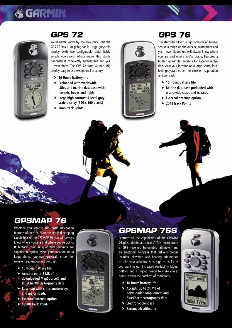
GPS 72You’d never know by the low price, but the GPS 72 has a lot going for it. Large greyscale display with user-confi gurable data fi elds. Simple operations. What’s more, this sturdy handheld is completely submersible and yes, it even fl oats. The GPS 72 from Garmin. Big display, easy to use, exceptional accuracy.
16 Hours battery life Preloaded with worldwide
cities and marine database with navaids, buoys and lights.
Large high-contrast 4-level grey scale display (120 x 160 pixels)
2048 Track Points
GPS 76This sturdy handheld is right at home on land or sea. It is tough on the outside, waterproof and yes, it even fl oats. You will always know where you are and where you’re going. Features a built-in quadrifi lar antenna for superior recep-tion. View your location on a large, sharp, four-level greyscale screen for excellent separation and contrast.
16 Hours battery life Marine database preloaded with
worldwide cities and navaids External antenna option 2048 Track Points
GPSMAP 76SFeatures all the capabilities of the GPSMAP 76 plus additional ‘sensors’. This incorporates a GPS receiver, barometric altimeter, and an electronic compass that delivers precise location, elevation and bearing information to take your adventures as high or as far as you want to go! Increased readability, bigger buttons and a rugged design to make you at home in even the harshest of conditions!
10 Hours battery life Accepts up to 24 MB of
downloaded MapSource® and BlueChart® cartography data
Electronic compass Barometric altimeter
GPSMAP 76 Whether you choose the basic navigation features of the GPS 76 or the detailed mapping capabilities of the GPSMAP 76, you will always know where you are and where you’re going. It features built-in quadrifi lar antenna for superior reception. View your location on a large, sharp, four-level greyscale screen for excellent separation and contrast.
16 Hours battery life Accepts up to 8 MB of
downloaded MapSource® and BlueChart® cartography data
Basemap with cities, motorways and major roads.
External antenna option 10000 Track Points

GPSMAP 76CThe GPSMAP 76C is a new update to the GPSMAP 76 family of handheld products. The GPSMAP 76C offers all the existing features found in the GPSMAP 76 such as the internal quad helix antenna, fully waterproof to IPX 7, it fl oats, has large easy to access buttons, uses 2 AA batteries, an international basemap that provides general coastline detail while also showing major roads and cities, is BlueChart®
compatible and it all fi ts in the same size case. What is different is that the GPSMAP 76C offers a sunlight viewable 256 colour display. It also comes with a huge 115 MB downloadable memory. And to ensure fast data loading, the GPSMAP 76C now offers USB compatibility while still offering the standard NMEA inter-face capability for normal marine interfaces. The GPSMAP 76C also offers turn by turn routing on the basemap, or the unit can take MapSource® City Navigator® data for full street level detail and address and point of interest look up capability.
GPSMAP 76CSFeatures all the capabilities of the GPSMAP 76C plus additional ‘sensors’. This incorporates a GPS receiver, barometric altimeter, and an electronic compass that delivers precise location, elevation and bearing information to take your adventures as high or as far as you want to go! Increased readability, bigger buttons and a rugged design to make you at home in even the harshest of conditions!
20 Hours battery life Pacifi c routable basemap that
provides general coastline detail while also showing major roads and cities
Sunlight viewable 256 colour display
115 MB downloadable memory for marine cartography and also street level details
Electronic compass Barometric altimeter
GPSMAP 60CWith a new rugged case design, the GPSMAP 60C introduces many exciting features includ-ing new TFT 256 colour display technology, producing one of the brightest, sunlight-readable displays available. With separate serial and USB interfaces. Detailed maps may be transferred to the unit using the USB interface. Navigation instructions can be shared with repeaters, plotters and autopilots using NMEA protocols through the dedicated serial port. The GPSMAP 60C also incudes a built-in International basemap with auto-routing capabilities. Completely waterproof with batterylife exceeding 25 hours, this new product is targeted to the marine and outdoor recreation markets. The GPSMAP 60C is fully compatible with MapSource® products like BlueChart® and City Navigator® providing detailed streets for turn-by-turn guidance.
GPSMAP 60CSThe GPSMAP 60CS features all the capabilities of the GPSMAP 60C plus additional ‘sensors’. This incorporates a barometric altimeter and an electronic compass that delivers precise location, elevation and bearing information to take your adventures as high or as far as you want to go!
Pacifi c routable basemap Sunlight viewable 256
colour display Tidal data from
BlueChart® CD available 30 Hours battery life
Tidal data from BlueChart CD available 30 Hours battery life Sunlight viewable 256 colour display 56MB Internal memory Trip and Waypoint Manager software,
cable included Belt clip
20 Hours battery life Sunlight viewable 256
colour display 56 MB Internal memory Electronic compass Barometric altimeter Trip and Waypoint
Manager software and cable included
Belt clip
115 MB downloadable memory for marine cartography and also street level details
Trip and Waypoint Manager software, cable included

handheld comparison chart
A Division of:Standard Communications PTY. LTD.
HEAD OFFICE: Locked Bag 2086 North Ryde NSW 1670 AustraliaPhone: +61 (0)2 9844 6666 Fax: +61 (0)2 9844 6600 Website: www.gme.net.au
MELBOURNE: (03) 9590 9333 SYDNEY: (02) 9879 8888 BRISBANE: (07) 3278 6444 ADELAIDE: (08) 8234 2633 PERTH: (08) 9455 5744 AUCKLAND: (09) 274 0955
Dealer:
No. of Waypoints
Built-in Memory
No. of Routes/
Waypoints per Route
No. of Tracklog
Points
Database & Basemap
Additional Map Option
Area Calcula-
tion
Auto Routing
Audible Alarms
Proximity Waypoints
Built-In Electronic Compass & Barometric Altimeter
Celestial Info Page
Alarm Clock &
Stopwatch
Unit Size(H x W x D)
(mm)
Display Size
(mm)
Display Type
Pixels (H x W) Antenna
PC Inter-face
Battery Life
ForeTrex 101 500 N/A 20/125 10000 N/A N/A No No No N/A No Yes No 43 x 84 x 23 23 x 36 B&W LCD 64 x 100 Patch Serial 15 Hr2 x AAA
ForeTrex 201 500 N/A 20/125 10000 N/A N/A No No No N/A No Yes No 43 x 84 x 23 23 x 36 B&W LCD 64 x 100 Patch Serial15 Hr
Recharge-able
Geko 101 250 N/A N/A 3000 N/A N/A No No No N/A No No No 99 x 48 x 24 36 x 23 B&W LCD 100 x 64 Patch N/A 12 Hr2 x AAA
Geko 201 500 N/A 20/125 10000 N/A N/A No No No N/A No Yes No 99 x 48 x 24 36 x 23 B&W LCD 100 x 64 Patch Serial 12 Hr2 x AAA
Geko 301 500 N/A 20/125 10000 N/A N/A Yes No No N/A Yes Yes No 99 x 48 x 24 36 x 23 B&W LCD 100 x 64 Patch Serial 9 Hr2 x AAA
eTrex 500 N/A 1/50 1536 N/A N/A No No No N/A No No No 112 x 51 x 30 53 x 284 level Grey LCD
128 x 64 Patch Serial 22 Hr2 x AA
eTrex Camo 500 N/A 1/50 2000 N/A N/A No No No N/A No Yes No 112 x 51 x 30 53 x 284 level Grey LCD
128 x 64 Patch Serial 22 Hr2 x AA
eTrex Summit 500 N/A 20/50 3000 N/A N/A No No No N/A Yes No No 112 x 51 x 30 53 x 284 level Grey LCD
128 x 64 Patch Serial22 Hr (GPS Only) 2 x AA
eTrex Venture 500 1 MB 20/50 2048World-
wide City Database
MapSource POI Yes No No N/A No Yes No 112 x 51 x 30 53 x 28
4 level Grey LCD
288 x 160 Patch Serial 20 Hr2 x AA
eTrex Legend 1000 8 MB 20/125 10000
Pacifi c Highway & Marine
Point Database
MapSourceMetroGuide or BlueChart
Yes No No N/A No Yes No 112 x 51 x 30 53 x 284 level Grey LCD
288 x 160 Patch Serial 18 Hr2 x AA
eTrex Vista 1000 24 MB 20/125 10000
Pacifi c Highway & Marine
Point Database
MapSourceMetroGuide or BlueChart
Yes No No N/A Yes Yes No 112 x 51 x 30 53 x 284 level Grey LCD
288 x 160 Patch Serial 12 Hr2 x AA
eTrex Legend C 500 24 MB 50/250 10000Pacifi c
RoutableBasemap
MapSourceCity Nav,
MetroGuide or BlueChart
Yes Yes Yes Yes No Yes Yes 107 x 56 x 30 43 x 33256
Colour TFT
220 x 176 Patch USB 36 Hr2 x AA
eTrex Vista C 500 24 MB 50/250 10000Pacifi c
RoutableBasemap
MapSourceCity Nav,
MetroGuide or BlueChart
Yes Yes Yes Yes Yes Yes Yes 107 x 56 x 30 43 x 33256
Colour TFT
220 x 176 Patch USB 20 Hr2 x AA
GPS 72 500 1 MB 50/50 2048
Marine Point data,
Navaids and major
cities
MapSource POI Yes No Yes Yes No Yes No 157 x 69 x 30 41 x 56
4 Level Grey LCD
160 x 120 Quad Helix Serial 16 Hr2 x AA
GPS 76 500 1 MB 50/50 2048
Marine Point data,
Navaids and major
cities
MapSource POI Yes No Yes Yes No Yes No 157 x 69 x 30 41 x 56
4 Level Grey LCD
240 x 180Quad Helix
External Connection
Serial 16 Hr2 x AA
GPSMAP 76 1000 8 MB 50/125 10000 Pacifi c Basemap
MapSource MetroGuide or BlueChart
Yes No Yes Yes No Yes No 157 x 69 x 30 41 x 564 Level
Grey LCD
240 x 180Quad Helix
External Connection
Serial 16 Hr2 x AA
GPSMAP 76S 1000 24 MB 50/125 10000 Pacifi c Basemap
MapSource MetroGuide or BlueChart
Yes No Yes Yes Yes Yes No 157 x 69 x 30 41 x 564 Level
Grey LCD
240 x 180Quad Helix
External Connection
Serial 10 Hr2 x AA
GPSMAP 76C 1000 115 MB 50/250 10000
Pacifi c Routable Basemap
MapSourceCity Nav,
MetroGuide or BlueChart
Yes Yes Yes Yes No Yes Yes 157 x 69 x 30 38 x 56256
Colour TFT
240 x 160Quad Helix
External Connection
Serial/USB
30 Hr2 x AA
GPSMAP 76CS 1000 115 MB 50/250 10000
Pacifi c Routable Basemap
MapSourceCity Nav,
MetroGuide or BlueChart
Yes Yes Yes Yes Yes Yes Yes 157 x 69 x 30 38 x 56256
Colour TFT
240 x 160Quad Helix
External Connection
Serial/USB
20 Hr2 x AA
GPSMAP 60C 1000 56 MB 50/250 10000Pacifi c
Routable Basemap
MapSourceCity Nav,
MetroGuide or BlueChart
Yes Yes Yes Yes No Yes Yes 155 x 61 x 33 38 x 56256
Colour TFT
240 x 160Quad Helix
External Connection
Serial/USB
30 Hr2 x AA
GPSMAP 60CS 1000 56 MB 50/250 10000Pacifi c
Routable Basemap
MapSourceCity Nav,
MetroGuide or BlueChart
Yes Yes Yes Yes Yes Yes Yes 155 x 61 x 33 38 x 56256
Colour TFT
240 x 160Quad Helix
External Connection
Serial/USB
20 Hr2 x AA
All Handheld Units have the following specifi cations:
Receiver: 12 Parallel channel receiver continuously tracks and uses 12 satellites to compute and update positionAcquisition Time: Warm: Approx. 15 seconds, Cold: Approx. 45 seconds, Autolocate: Approx. 5 minutes (Update rate 1 second continuous)Accuracy: Position: <5 metres, 95% typical Velocity: 0.05 metre/sec steady state
Basemap for general orientation and reference only.
Specifi cations are preliminary and subject to change without notice.
Iss.1-12/04-583-JF
Exclusive Australasian Distributor