Embed Size (px)
Citation preview
2014 Airport Master Plan Narrative Report
Priest River Municipal Airport5-1
5.0 ALTERNATIVES ANALYSIS
The Alternative Analysis chapter describes and evaluates the various development alternatives
considered for Priest River Municipal Airport. In addition, it presents a preferred development
plan that accommodates the identified demand, facility requirements and recommendations
based on the Aviation Activity Forecasts and Facility Requirements chapters of this airport
master plan.
Multiple options for both airside and landside alternatives were considered by the planning team
and the County in arriving at the preferred alternatives. The preferred alternative serves as the
basis for the Airport Layout Plan (ALP) drawing set shown in Chapter 8
5.1 AIRPORT DEVELOPMENT ASSUMPTIONS
Previous chapters of the Airport Master Plan have analyzed the impact of various development
strategies at the airport and the practical application of these strategies led to several
development alternatives. In particular, Chapter 3, Aviation Activity Forecasts, outlined future
demand for improvements to airport facilities and Chapter 4, Facility Requirements, addressed
the impact growth may have on specific airport features such as the runway, taxiway system,
aprons and hangar space. This chapter will take the process a step further and outline specific
development alternatives as well as the rationale behind the selection of specific alternatives.
The following sections describe specific considerations for development of the selected
alternatives.
5.1.1 AIRPORT USERS
Chapter 3, Aviation Activity Forecasts, profiled typical users of the Priest River Municipal Airport
today and over the course of the planning horizon. Currently, single-engine piston aircraft are
the primary users of the airport, with occasional use by small turbo-prop and multi-engine
aircraft. This group will continue to dominate the demographic of the airport during the planning
period.
5.1.2 ACTIVITY LEVELS
The level of activity at Priest River Municipal Airport is predicted to slowly increase during the
planning period. The growth of both based aircraft and total number of operations reflects
national and state trends in aviation activity. Details of projected growth are reflected in Chapter
3, Aviation Activity Forecasts.
2014 Airport Master Plan Narrative Report
Priest River Municipal Airport5-2
5.1.3 FACILITIES CONFIGURATION
The configuration of existing facilities at Priest River Municipal Airport was also a determining
factor when analyzing the potential layout of future facilities. The layout of new aprons, taxiways
and hangars must be complementary to existing facilities to provide useable and cost effective
options to the airport. This Airport Master Plan seeks to make use of existing facilities to the
greatest extent possible and enhance them for future development.
5.2 AIRPORT DEVELOPMENT GOALS
Realistic goals for development, which reflect the role of Priest River Municipal Airport in the
community, have been identified in this planning effort. These goals were developed with
consideration of both the short-term and long-term needs of the airport including interest of
airport users, compatibility with the surrounding land use, safety, noise, and financial and
economic conditions.
These goals include:
Preparation of a logical development program for the airport that provides a realistic
vision for the future.
Analysis that provides financially feasible projects that enhance the self-sustaining
capability of the airport.
Adherence to minimum design standards and rules and regulations.
Preservation of existing private and public investment in the airport and related facilities
through land use compatibility.
As mentioned in Chapter 4, Facility Requirements, it is understood that the need for full
build-out of the airport as depicted on the ALP drawing set is unlikely and not justified
based on the aviation activity forecasts performed as part of this study. Nevertheless,
recommendations and alternatives have been developed based on a proactive planning
approach whereby long-term guidance has been presented to the County to assist them in
facilitating logical and orderly development over the planning period, and beyond.
When such a plan does not exist, it is not uncommon to make development decisions based on
what is most convenient and expedient at the time. For example, a new tenant may wish to build
a hangar at a certain location at the airport. In the short-term, this location may work fine and be
expedient. In the long-term, however, this location might have been better suited for other future
development. The alternatives and plan presented provide the roadmap and guidance to
Bonner County to avoid falling into this trap. Further, it is understood that inclusion of the
identified projects on the ALP do not indicate a commitment on the part of the FAA or the State
of Idaho to provide funding for any or all of the projects. That being said, projects are not eligible
if not shown on the airport’s approved ALP.
2014 Airport Master Plan Narrative Report
Priest River Municipal Airport5-3
As previously stated, many of the recommendations contained in this planning study are
demand driven and will only be considered when and if demand at the airport warrants.
5.3 EVALUATION CRITERIA
In order to assess and evaluate the different alternatives, several evaluation criteria were used:
Operational and Feasible
Environmental
Compatibility with future needs
Cost
Operational and Feasible
The operational and feasible criterion assesses the ability to accommodate current and
forecasted demand in a safe and efficient manner, as well as the construction feasibility of each
alternative.
Environmental
This criterion assesses the level of environmental impacts and environmental disruptions,
including the potential impacts on the surrounding population, as Priest River Municipal Airport
is located in an urban and developed environment.
Compatibility with future needs
This criterion assesses the compatibility with future short- and long-term needs.
Cost
This evaluation criterion provides an estimation of the project expenses and assesses the ability
to answer the needs costs-effectively.
2014 Airport Master Plan Narrative Report
Priest River Municipal Airport5-4
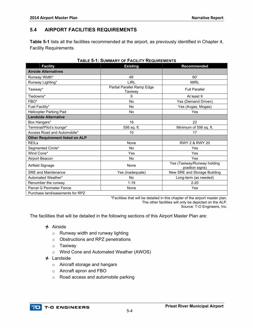
5.4 AIRPORT FACILITIES REQUIREMENTS
Table 5-1 lists all the facilities recommended at the airport, as previously identified in Chapter 4,
Facility Requirements.
TABLE 5-1: SUMMARY OF FACILITY REQUIREMENTS
Facility Existing Recommended
Airside Alternatives
Runway Width* 48’ 60'
Runway Lighting* LIRL MIRL
Taxiway*Partial Parallel Ramp Edge
TaxiwayFull Parallel
Tiedowns* 9 At least 9
FBO* No Yes (Demand Driven)
Fuel Facility* No Yes (Avgas, Mogas)
Helicopter Parking Pad No Yes
Landside Alternative
Box Hangars* 16 22
Terminal/Pilot’s lounge* 556 sq. ft. Minimum of 556 sq. ft.
Access Road and Automobile* 10 17
Other Requirement listed on ALP
REILs None RWY 2 & RWY 20
Segmented Circle* No Yes
Wind Cone* Yes Yes
Airport Beacon No Yes
Airfield Signage NoneYes (Taxiway/Runway holding
position signs)
SRE and Maintenance Yes (inadequate) New SRE and Storage Building
Automated Weather* No Long-term (as needed)
Renumber the runway 1-19 2-20
Parcel G Perimeter Fence None Yes
Purchase land/easements for RPZ
*Facilities that will be detailed in this chapter of the airport master plan. The other facilities will only be depicted on the ALP.
Source: T-O Engineers, Inc.
The facilities that will be detailed in the following sections of this Airport Master Plan are:
Airside
o Runway width and runway lighting
o Obstructions and RPZ penetrations
o Taxiway
o Wind Cone and Automated Weather (AWOS)
Landside
o Aircraft storage and hangars
o Aircraft apron and FBO
o Road access and automobile parking
2014 Airport Master Plan Narrative Report
Priest River Municipal Airport5-5
The other facilities that do not result in a detailed analysis of alternatives. However, they will be
listed and depicted on the ALP as appropriate.
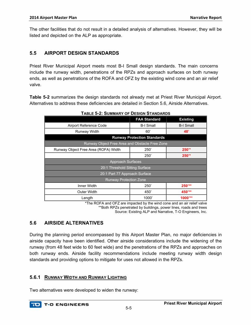
5.5 AIRPORT DESIGN STANDARDS
Priest River Municipal Airport meets most B-I Small design standards. The main concerns
include the runway width, penetrations of the RPZs and approach surfaces on both runway
ends, as well as penetrations of the ROFA and OFZ by the existing wind cone and an air relief
valve.
Table 5-2 summarizes the design standards not already met at Priest River Municipal Airport.
Alternatives to address these deficiencies are detailed in Section 5.6, Airside Alternatives.
TABLE 5-2: SUMMARY OF DESIGN STANDARDS
FAA Standard Existing
Airport Reference Code B-I Small B-I Small
Runway Width 60’ 48’
Runway Protection Standards
Runway Object Free Area and Obstacle Free Zone
Runway Object Free Area (ROFA) Width 250’ 250’*
Runway Obstacle Free Zone Width (OFZ) 250’ 250’*
Approach Surfaces
20:1 Threshold Sitting Surface
20:1 Part 77 Approach Surface
Runway Protection Zone
Inner Width 250’ 250’**
Outer Width 450’ 450’**
Length 1000’ 1000’**
*The ROFA and OFZ are impacted by the wind cone and an air relief valve**Both RPZs penetrated by buildings, power lines, roads and trees
Source: Existing ALP and Narrative, T-O Engineers, Inc.
5.6 AIRSIDE ALTERNATIVES
During the planning period encompassed by this Airport Master Plan, no major deficiencies in
airside capacity have been identified. Other airside considerations include the widening of the
runway (from 48 feet wide to 60 feet wide) and the penetrations of the RPZs and approaches on
both runway ends. Airside facility recommendations include meeting runway width design
standards and providing options to mitigate for uses not allowed in the RPZs.
5.6.1 RUNWAY WIDTH AND RUNWAY LIGHTING
Two alternatives were developed to widen the runway:
2014 Airport Master Plan Narrative Report
Priest River Municipal Airport5-6
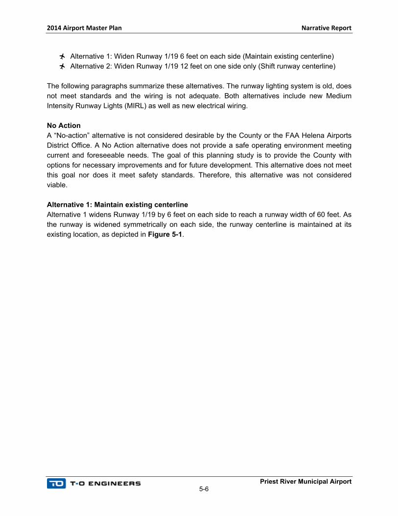
Alternative 1: Widen Runway 1/19 6 feet on each side (Maintain existing centerline)
Alternative 2: Widen Runway 1/19 12 feet on one side only (Shift runway centerline)
The following paragraphs summarize these alternatives. The runway lighting system is old, does
not meet standards and the wiring is not adequate. Both alternatives include new Medium
Intensity Runway Lights (MIRL) as well as new electrical wiring.
No Action
A “No-action” alternative is not considered desirable by the County or the FAA Helena Airports
District Office. A No Action alternative does not provide a safe operating environment meeting
current and foreseeable needs. The goal of this planning study is to provide the County with
options for necessary improvements and for future development. This alternative does not meet
this goal nor does it meet safety standards. Therefore, this alternative was not considered
viable.
Alternative 1: Maintain existing centerline
Alternative 1 widens Runway 1/19 by 6 feet on each side to reach a runway width of 60 feet. As
the runway is widened symmetrically on each side, the runway centerline is maintained at its
existing location, as depicted in Figure 5-1.
2014 Airport Master Plan Narrative Report
Priest River Municipal Airport5-7
FIGURE 5-1: MAINTAIN EXISTING CENTERLINE
Minor environmental impacts are expected as a result of the construction and grading
operations. No land acquisition is needed as this alternative remains within the existing airport
property limits and all construction occurs on previously disturbed land. This alternative does not
change the runway protection or separation standards, as the runway centerline is maintained
at its current location.
The estimated cost of this project is $1,669,000, including REILs and a PAPI.
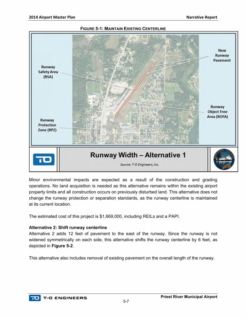
Alternative 2: Shift runway centerline
Alternative 2 adds 12 feet of pavement to the east of the runway. Since the runway is not
widened symmetrically on each side, this alternative shifts the runway centerline by 6 feet, as
depicted in Figure 5-2.
This alternative also includes removal of existing pavement on the overall length of the runway.
2014 Airport Master Plan Narrative Report
Priest River Municipal Airport5-8
FIGURE 5-2: SHIFT RUNWAY CENTERLINE
Minor environmental impacts are expected as a result of the construction and grading
operations. No land acquisition is needed and this alternative remains within the existing airport
property limits. All construction occurs on previously disturbed land.
As the runway centerline shifts by 6 feet, this alternative also shifts the RSA, ROFA, OFZ and
RPZ by 6 feet. In addition, the runway to taxiway separation increases from 150 feet (minimum
distance required for B-I Small airports) to 156 feet.
The estimated cost of this project is $1,710,000, including REILs and a PAPI on the Runway 1
end.
Alternatives Evaluation
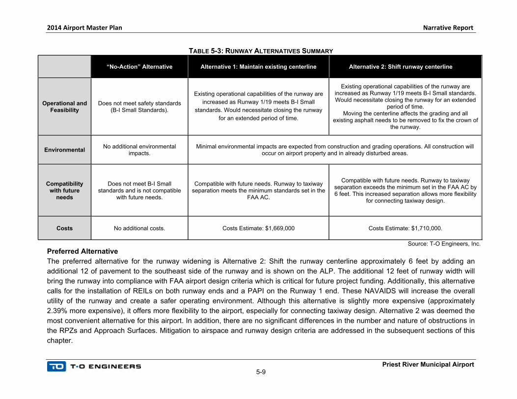
Table 5-3 summarizes the different alternatives in relation to the selected criteria.
2014 Airport Master Plan Narrative Report
Priest River Municipal Airport5-9
TABLE 5-3: RUNWAY ALTERNATIVES SUMMARY
“No-Action” Alternative Alternative 1: Maintain existing centerline Alternative 2: Shift runway centerline
Operational and Feasibility
Does not meet safety standards (B-I Small Standards).
Existing operational capabilities of the runway are
increased as Runway 1/19 meets B-I Small
standards. Would necessitate closing the runway
for an extended period of time.
Existing operational capabilities of the runway are increased as Runway 1/19 meets B-I Small standards. Would necessitate closing the runway for an extended
period of time. Moving the centerline affects the grading and all
existing asphalt needs to be removed to fix the crown of the runway.
EnvironmentalNo additional environmental
impacts.Minimal environmental impacts are expected from construction and grading operations. All construction will
occur on airport property and in already disturbed areas.
Compatibility with future
needs
Does not meet B-I Small standards and is not compatible
with future needs.
Compatible with future needs. Runway to taxiway separation meets the minimum standards set in the
FAA AC.
Compatible with future needs. Runway to taxiway separation exceeds the minimum set in the FAA AC by 6 feet. This increased separation allows more flexibility
for connecting taxiway design.
Costs No additional costs. Costs Estimate: $1,669,000 Costs Estimate: $1,710,000.
Source: T-O Engineers, Inc.
Preferred Alternative
The preferred alternative for the runway widening is Alternative 2: Shift the runway centerline approximately 6 feet by adding an
additional 12 of pavement to the southeast side of the runway and is shown on the ALP. The additional 12 feet of runway width will
bring the runway into compliance with FAA airport design criteria which is critical for future project funding. Additionally, this alternative
calls for the installation of REILs on both runway ends and a PAPI on the Runway 1 end. These NAVAIDS will increase the overall
utility of the runway and create a safer operating environment. Although this alternative is slightly more expensive (approximately
2.39% more expensive), it offers more flexibility to the airport, especially for connecting taxiway design. Alternative 2 was deemed the
most convenient alternative for this airport. In addition, there are no significant differences in the number and nature of obstructions in
the RPZs and Approach Surfaces. Mitigation to airspace and runway design criteria are addressed in the subsequent sections of this
chapter.
2014 Airport Master Plan Narrative Report
Priest River Municipal Airport5-10
5.6.2 RPZS AND APPROACH PENETRATIONS
The RPZs on both runway ends are penetrated by uses not allowed in the RPZ; namely, Runway 19 by
State Highway 57 and Runway 1 by Cemetery Road. Other obstructions located in both the RPZ and
approach surfaces on each end include trees and power lines, as well as buildings. The portion of both
the 20:1 Threshold Siting Surface (TSS) and the CFR Part 77 20:1 Visual Approach Surface were
evaluated for obstruction penetrations in each of the alternatives.
Five alternatives, including a no-action alternative, were developed to mitigate the penetrations in the
RPZs and approach surfaces:
No Action Alternative
Alternative 1: Land Acquisition and Incompatible Land Uses Removal
Alternative 2: RPZs Partially Cleared and Declared Distances
Alternative 3: Declared Distances and Additional Pavement (461’)
Alternative 4: Declared Distances and Additional Pavement (1,060’)
The following paragraphs summarize these alternatives.
No Action
A “No-action” consists of maintaining the existing situation at the airport. This alternative does not clear
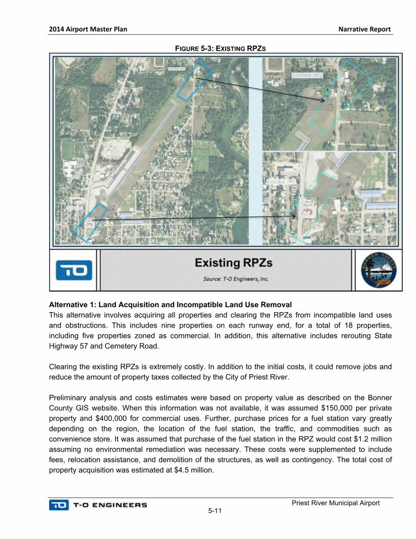
any obstructions in the RPZ or approaches. Figure 5-3 depicts the existing situation at the airport.
This alternative is not desirable by the FAA Helena Airports District Office (ADO). A No-Action
alternative does not meet safety standards and RPZ design standards. The FAA considers that a no-
action alternative does not provide a safe operating environment to meet current and foreseeable
needs. This alternative is not considered viable by the FAA Helena ADO.
In addition, the FAA does not consider a “no-action” alternative feasible, even if it includes a plan to
clear the structures as land becomes available as part of the variance. If Priest River Municipal Airport
wants to acquire the structures in the future as they become available, cleared RPZs will be necessary
during the transition, and declared distances will have to be enforced until the RPZs are cleared.
2014 Airport Master Plan Narrative Report
Priest River Municipal Airport5-11
FIGURE 5-3: EXISTING RPZS
Alternative 1: Land Acquisition and Incompatible Land Use Removal
This alternative involves acquiring all properties and clearing the RPZs from incompatible land uses
and obstructions. This includes nine properties on each runway end, for a total of 18 properties,
including five properties zoned as commercial. In addition, this alternative includes rerouting State
Highway 57 and Cemetery Road.
Clearing the existing RPZs is extremely costly. In addition to the initial costs, it could remove jobs and
reduce the amount of property taxes collected by the City of Priest River.
Preliminary analysis and costs estimates were based on property value as described on the Bonner
County GIS website. When this information was not available, it was assumed $150,000 per private
property and $400,000 for commercial uses. Further, purchase prices for a fuel station vary greatly
depending on the region, the location of the fuel station, the traffic, and commodities such as
convenience store. It was assumed that purchase of the fuel station in the RPZ would cost $1.2 million
assuming no environmental remediation was necessary. These costs were supplemented to include
fees, relocation assistance, and demolition of the structures, as well as contingency. The total cost of
property acquisition was estimated at $4.5 million.
2014 Airport Master Plan Narrative Report
Priest River Municipal Airport5-12
As preliminary options, two alignments were considered for the relocation of State Highway 57: one
alignment to the east of the City of Priest River, improving Bodie Canyon Road, and one alignment
maintaining State Highway 57 at its current location, but rerouting a portion of it out of the RPZ. Costs
estimates to improve Bodie Canyon Road are $5,070,000 (including right-of-way acquisition). However,
this option does not provide adequate connectivity to the City of Priest River. The fire station is located
on the airport and would not be able to adequately access the town. Other roads would need to be
improved to provide appropriate connectivity.
The second option requires relocating 33 residences and 6 businesses. No further analysis was
conducted on this option as the environmental impacts (socio-economic and environmental justice
impacts) were considered too high for a town of 743 households.
Cost estimates to reroute Cemetery Road around the RPZ are $530,000, this cost includes the
relocation of approximately 1,500 feet of unpaved roadway.
Using the Bodie Canyon Road alignment, a preliminary cost estimate for planning purpose indicates
that Alternative 1 would cost over $10.1 million.
This alternative is not considered desirable by the County because of the socioeconomic impacts on
the community and the City of Priest River.
Alternative 2: RPZ Partially Cleared and Declared Distances
This alternative consists of enforcing declared distances to clear the RPZs on each end of the runway.
According to the FAA Advisory Circular AC 150/5300-13A, Change 1, Paragraph 322.a: “Declared
distances represent the maximum distances available and suitable for meeting takeoff, rejected takeoff,
and landing distances performance requirements. The declared distances are Take Off Run Available
(TORA) and Take Off Distance Available (TODA), which apply to takeoff; Accelerate Stop Distance
Available (ASDA), which applies to a rejected takeoff; and Landing Distance Available (LDA), which
applies to landing.”
Further, the AC 150/5300-13A, Change 1, Paragraph 322.a (1) states: “Declared distances may be
used to obtain additional RSA and/or ROFA prior to the runway’s threshold (the start of the LDA) and/or
beyond the stop end of the LDA and ASDA, to mitigate unacceptable incompatible land uses in the
RPZ, to meet runway approach and/or departure surface clearance requirements, in accordance with
airport design standards, or to mitigate environmental impacts.”
This alternative does not maintain the RPZs entirely on airport property, but it was discussed with the
Helena ADO as an option to limit the runway length reduction. This alternative clears the RPZs from
building and structures. However, State Highway 57 and Cemetery Road are both in the corners of the
RPZs. The RSA, ROFA and OFZ are maintained on airport property.
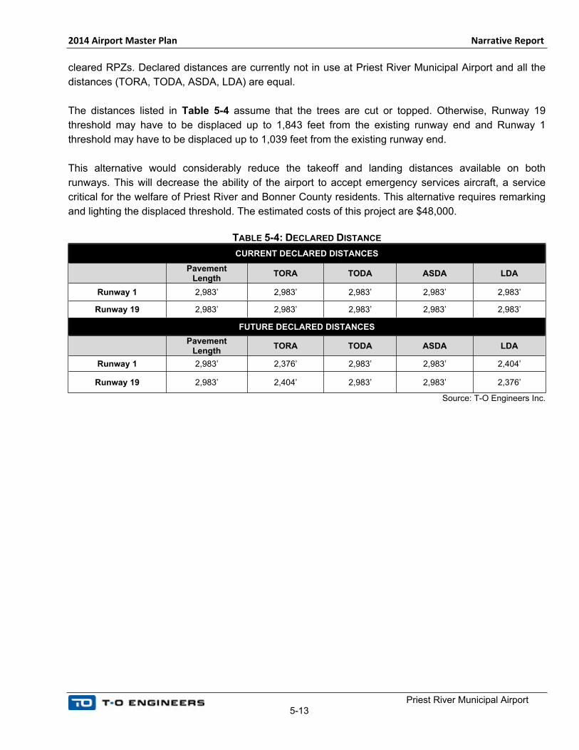
Table 5-4 lists the declared distances that would be in effect at Priest River Municipal Airport to mitigate
obstructions and unacceptable incompatible land uses in the RPZ, and Figure 5-5 depicts the partially
2014 Airport Master Plan Narrative Report
Priest River Municipal Airport5-13
cleared RPZs. Declared distances are currently not in use at Priest River Municipal Airport and all the
distances (TORA, TODA, ASDA, LDA) are equal.
The distances listed in Table 5-4 assume that the trees are cut or topped. Otherwise, Runway 19
threshold may have to be displaced up to 1,843 feet from the existing runway end and Runway 1
threshold may have to be displaced up to 1,039 feet from the existing runway end.
This alternative would considerably reduce the takeoff and landing distances available on both
runways. This will decrease the ability of the airport to accept emergency services aircraft, a service
critical for the welfare of Priest River and Bonner County residents. This alternative requires remarking
and lighting the displaced threshold. The estimated costs of this project are $48,000.
TABLE 5-4: DECLARED DISTANCE
CURRENT DECLARED DISTANCES
Pavement Length
TORA TODA ASDA LDA
Runway 1 2,983’ 2,983’ 2,983’ 2,983’ 2,983’
Runway 19 2,983’ 2,983’ 2,983’ 2,983’ 2,983’
FUTURE DECLARED DISTANCES
Pavement Length
TORA TODA ASDA LDA
Runway 1 2,983’ 2,376’ 2,983’ 2,983’ 2,404’
Runway 19 2,983’ 2,404’ 2,983’ 2,983’ 2,376’
Source: T-O Engineers Inc.

2014 Airport Master Plan Narrative Report
Priest River Municipal Airport5-14
FIGURE 5-4: PARTIALLY CLEARED RPZ
2014 Airport Master Plan Narrative Report
Priest River Municipal Airport5-15
Alternative 3: Declared Distances and Additional Pavement (832’)
Alternative 3 is similar to Alternatives 2 in that it consists of enforcing declared distances at the airport.
However, this alternative consists of two steps. The first step includes displacing both runway
thresholds and extending the runway pavement on both ends to minimize the takeoff and landing
distance reduction due to the declared distances. Given the constrained environment of the airport, this
runway pavement extension would remain entirely on existing airport property and maintain the RSA,
ROFA and OFZ on airport property. The thresholds would be displaced approximately 538 feet on the
approach end of Runway 19 and 578 feet on the approach end of Runway 01. The Runway 19 end
would be extended 221 feet and the Runway 1 end would be extended 236 feet, for a total pavement
length of 3,440 feet. The RPZs on both ends will be cleared with the exception of State Highway 57 and
Cemetery Road. The TORA for Runways 2 and 20 departures will be reduced by 302 feet and 357 feet
respectively. Similarly, these reductions apply to the LDA as well.
Phase two of Alternative 3 includes shifting the Runway 20 threshold 120 feet east reducing the impact
of declared distances and creating more usable runway length. Shifting the threshold back will relocate
the RPZ over the property boundaries of up to twelve parcels near the runway end. These properties
will need to be acquired and their developments mitigated prior to shifting the threshold and changing
the declared distances. The ultimate design would add an additional 375 feet of pavement beyond step
one and would allow the Runway 20 threshold to be shifted 138 feet increasing the declared distances
for both runways.
Table 5-5 lists the declared distances that would be in effect during step 1 and step 2, to mitigate the
obstructions and unacceptable incompatible land uses in the RPZ. Figure 5-5 depicts the RPZs. As
previously mentioned, these distances assume that the trees are cut or topped. Terrain and trees in
Runway 19 approach penetrates the Threshold Siting Surface (TSS). The displaced threshold due to
these obstructions is more restrictive than the displaced threshold to clear the RPZ. Even if the RPZ is
cleared, Runway 19 LDA has to be limited to 2,750’. Mitigation measures including obstruction lighting
will be further discussed in Section 5.6.3 Obstructions and Approach Surface.
This alternative necessitates additional construction to extend the runway that will be limited to on-
airport property. The estimated costs of Step 1 are $379,000. Step 2 consists in acquiring land as it
becomes available. Preliminary estimated costs are $2,208,803 (based on property value as described
on the Bonner County GIS website and considering $400,000 for commercial use properties).
TABLE 5-5: DECLARED DISTANCE
CURRENT DECLARED DISTANCES
Pavement Length
TORA TODA ASDA LDA
Runway 1 2,983’ 2,983’ 2,983’ 2,983’ 2,983’
Runway 19 2,983’ 2,983’ 2,983’ 2,983’ 2,983’
FUTURE DECLARED DISTANCES – STEP 1
Pavement Length
TORA TODA ASDA LDA

2014 Airport Master Plan Narrative Report
Priest River Municipal Airport5-16
Runway 1 3,440’ 2,681 3,440’ 3,440’ 2,626’
Runway 19 3,440’ 2,626’ 3,440’ 3,440’ 2,681’
ULTIMATE DECLARED DISTANCES – STEP 2
Pavement Length
TORA TODA ASDA LDA
Runway 1 3,815’ 2,801’ 3,797’ 3,797’ 2,983’
Runway 19 3,815’ 2,983’ 3,797’ 3,797’ 2,801’
Source: T-O Engineers Inc.
FIGURE 5-5: EXTENSION AND PARTIALLY CLEARED RPZ
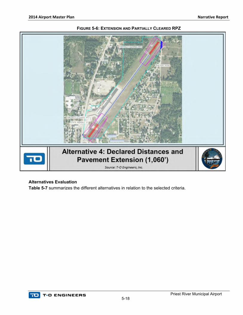
Alternative 4: Declared Distances and Additional Pavement (1,060’)
Alternative 4 consists of implementing declared distances, and adding pavement to minimize the
runway length reduction. However, this alternative does not maintain the RSA, ROFA and OFZ on
airport property. As the RSA, ROFA and OFZ are not maintained on airport property and are not
cleared of incompatible land uses, only the TORA and TODA would be extended. The ASDA and LDA
would be similar to the first step of Alternative 3. The Runway 19 end would be extended by 515 feet
and Runway 1 would be extended by 545 feet, for a total pavement length of 4,044 feet.
Table 5-6 lists the declared distances that would be in effect to mitigate the obstructions and
unacceptable incompatible land uses in the RPZ. Figure 5-6 depicts the cleared RPZs. As previously
mentioned, only the TORA and TODA would be longer than with Alternative 3, the ASDA and LDA

2014 Airport Master Plan Narrative Report
Priest River Municipal Airport5-17
would remain unchanged compared to the first step of Alternative 3. With this alternative, the TORA
would be at 2,921’, close to the existing TORA.
As previously mentioned, these distances assume that trees are cut or topped. Otherwise, Runway 19
threshold may have to be displaced up to 1,771 feet from the existing runway end and Runway 1
threshold may have to be displaced up to 978 feet from the existing runway end.
This alternative necessitates additional construction to extend the runway. However, this construction
will be limited to on airport property, in already disturbed and developed areas. The estimated costs of
this project are $870,000.
TABLE 5-6: DECLARED DISTANCE
CURRENT DECLARED DISTANCES
Pavement Length
TORA TODA ASDA LDA
Runway 1 2,983’ 2,983’ 2,983’ 2,983’ 2,983’
Runway 19 2,983’ 2,983’ 2,983’ 2,983’ 2,983’
FUTURE DECLARED DISTANCES
Pavement Length
TORA TODA ASDA LDA
Runway 1 4,044’ 2,921’ 4,044’ 3,444’ 2,629’
Runway 19 4,044’ 2,921’ 4,044’ 3,444’ 2,612’
Source: T-O Engineers Inc.
2014 Airport Master Plan Narrative Report
Priest River Municipal Airport5-18
FIGURE 5-6: EXTENSION AND PARTIALLY CLEARED RPZ
Alternatives Evaluation
Table 5-7 summarizes the different alternatives in relation to the selected criteria.
2014 Airport Master Plan Narrative Report
Priest River Municipal Airport5-19
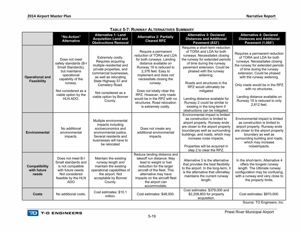
TABLE 5-7: RUNWAY ALTERNATIVES SUMMARY
“No-Action” Alternative
Alternative 1: Land Acquisition Land and Obstructions Removal
Alternative 2: Partially Cleared RPZ
Alternative 3: Declared Distances and Additional
Pavement (832’)
Alternative 4: Declared Distances and Additional
Pavement (1,060’)
Operational and Feasibility
Does not meet safety standards (B-I
Small Standards), but maintains operational
capability of the runway.
Not considered as a viable option by the
HLN ADO.
Extremely costly. Requires acquiring
multiple residential and private properties, and
commercial businesses, as well as relocating
State Highway 57 and Cemetery Road.
Not considered as a viable option by Bonner
County.
Require a permanent reduction of TORA and LDA for both runways. Landing
distance available on Runway 19 is reduced to
2,376 feet. Easy to implement and does not necessitate closing the
runway.
Does not totally clear the RPZ. However, only roads
would be in the RPZ with no structures. Road relocation
is extremely costly.
Requires a short-term reduction of TORA and LDA for both
runways. Necessitates closing the runway for extended periods
of time during the runway pavement extension. Could be
phased with the runway widening.
Roads and structures in the RPZ would ultimately be
mitigated
Landing distance available for Runway 2 could be similar to
existing in the long-term if obstructions can be mitigated.
Requires a permanent reduction of TORA and LDA for both
runways. Necessitates closing the runway for extended periods
of time during the runway extension. Could be phased with the runway widening.
Only roads would be in the RPZ with no structures.
Landing distance available on Runway 19 is reduced to only
2,612 feet.
EnvironmentalNo additional environmental
impacts.
Multiple environmental impacts including
socioeconomics and environmental justice. Several residents and businesses will have to
be relocated
Does not create any additional environmental
impacts.
Environmental impact is limited as construction is limited to
airport property. Runway ends are closer to the airport property boundaryas well as surrounding buildings, and roads, which may
increase noise impacts.
Properties will be acquired in step 2 to clear the RPZ.
Environmental impact is limited as construction is limited to
airport property. Runway ends are closer to the airport property
boundary as well as surrounding building and roads,
which may increase noiseimpacts.
Compatibility with future
needs
Does not meet B-I Small standards and
is not compatible with future needs.
Not considered feasible by the HLN
ADO
Maintain the existing runway length and
maintain the existing operational capabilities of
the airport. Not acceptable by Bonner
County.
Reduce landing distance and takeoff run distance. May
lead to weight or fuel reduction for the larger aircraft of the fleet. This
alternative may have impacts on the aircraft fleet
the airport can accommodate.
Alternative 3 is the alternative that provides the best flexibility
to the airport. In the long-term, it is the alternative that ultimatley maintains the current runway
length.
In the short-term, Alternative 4 offers the longest runway
length. The Ultimate runway configuration may be confusing, with a runway end very close to
the property limits.
Costs No additional costs.Cost estimates: $10.1
million.Cost estimates: $48,000.
Cost estimates: $379,000 and $2,208,803 for property
acquisition.Cost estimates: $870,000.
Source: TO Engineers, Inc.
2014 Airport Master Plan Narrative Report
Priest River Municipal Airport 5-20
Preferred Alternative
The preferred alternative to mitigate obstructions in the approach surface and incompatible land
uses in the RPZs is Alternative 3: Declared Distances and Additional Pavement, shown on the
ALP. This alternative was discussed at length with the FAA Helena ADO and County personnel
and determined to be the preferred alternative. Alternative 3 involves meeting federal standards
while minimizing the loss of utility to the runway. In order to mitigate obstructions to the
threshold siting surfaces and to meet federal standards the runway needs to be expanded to a
width of 60 feet and both runway ends need to be displaced with the implementation of declared
distances. By lengthening the runway pavement and clearing the RPZ and threshold siting
surfaces of obstructions and incompatible land uses, the airport is able to regain usable runway
length and reduce the impacts of declared distances.
The preferred alternative is a multi-phased approach that starts with extending the runway
pavement on both ends and displacing the thresholds. The second phase further extends the
pavement edge on the end of Runway 20 and adjusts the threshold accordingly thus gaining as
much utility as possible while maintaining a clear RPZ. This phase results in the ultimate
buildout of the runway and requires the relocation of a landside roadway; Cemetery Road. In
order to accommodate the roadway relocation, several properties near the runway end will need
to be procured and their structures mitigated.
The total estimated cost for this preferred alternative is $2,987,803 which includes the cost of
design, construction, acquisition of property, and obstruction removal.
5.6.3 OBSTRUCTIONS AND APPROACH SURFACES
There are various airspace surfaces that protect the airport environment and they each serve a
unique purpose. Title 14 Code of Federal Regulations Part 77 (Part 77) surfaces provide for
initial object identification and depict when an object becomes an obstruction and when it needs
to be mitigated or simply reviewed by the FAA. Other surfaces such as those referenced in the
United States Standard for Terminal Instrument Procedures (TERPS) can impact/reduce the
utility of the airport by amending published flight procedures when they are obstructed.
The most critical surfaces affecting any airport are the Threshold Siting Surfaces (TSS) which
are referenced in AC 150/5300-13A. Penetrations to the TSS can require displacement of
runway thresholds and the implementation of declared distances which can vastly reduce the
usability and viability of the airport. For the purpose of maintaining compliance with FAA grant
assurances, airport sponsors are required to actively mitigate penetrations to the Part 77
airspace surfaces.
In the case of Priest River Municipal Airport, there are numerous penetrations to the Part 77
surfaces and the TSS. As a result, the opportunity to seek future implementation of instrument
approach procedures is limited. Similarly, the current penetrations to the TSS make the airport
non-compliant with federal standards and negatively impact the siting of the runway thresholds.

2014 Airport Master Plan Narrative Report
Priest River Municipal Airport5-21
The RPZ preferred alternative referenced threshold displacement for the purpose of mitigating
obstructions within the RPZ; however, displacement of the threshold is required in order to
mitigate penetrations to TSS as well.
The approach surfaces on both runway ends are penetrated by a significant number of
obstacles. This includes mostly trees, but also the terrain as well as some power poles. To clear
the approach surface, the existing threshold of Runway 19 should be displaced by 469 feet and
the existing threshold of Runway 1 should be displaced by 100 feet. This assumes the trees are
cut or topped. If the trees are not mitigated, Runway 19 threshold may have to be displaced up
to 1,843 feet from the existing runway end and Runway 1 threshold may have to be displaced
up to 1,039 feet from the existing runway end.
Additional details on the number of obstructions for the existing and ultimate runway
configuration as well as mitigation measures are provided in Appendix X. As this is a safety
issue, it will have a high-priority for FAA funding and should be addressed in the short-term.
No Action
The “No Action” alternative would not meet FAA standards and accommodates an unsafe
environment for pilots and airport users. This alternative is not desirable by the County or the
FAA. Consequently, the “No Action” alternative is rejected and not considered a viable option for
the airport.
Alternative 1: Land Acquisition and Obstruction Removal
This alternative addresses airspace obstructions by the acquisition of land and/or avigation
easements from nearby owners whose property contains objects that penetrate critical
imaginary surfaces. Once the necessary land and/or easements have been procured, the
airspace obstructions can be removed.
The obstructions encompass up to 60 separate parcels under the approaches for both runways.
After the easements and properties have been acquired, the obstructions should be mitigated.
The mitigation process will be different depending on the object, the surface it penetrates, and
the significance of the penetration. The most preferred method of mitigation is removal but in
some cases not all objects can be removed or relocated. Other forms of mitigation include
obstruction marking, lighting, annotation on published departure procedures, and VGSI
mitigation.
Nearly all obstructions off the approach end of Runway 1 can be removed with the exception of
the power poles. These will likely require obstruction lighting. In the case of the Runway 19 end,
the obstructions on the west side of the can likely be removed, however the penetrations on the
east side of the river include both trees and terrain.
Alternatives Evaluation
Table 5-8 summarizes the different alternatives in relation to the selected criteria.

2014 Airport Master Plan Narrative Report
Priest River Municipal Airport5-22
TABLE 5-8: RUNWAY ALTERNATIVES SUMMARY
“No-Action” AlternativeAlternative 1: Land Acquisition Land
and Obstructions Removal
Operational and Feasibility
The “No Action” alternative does not meet the needs of the airport, the County, or the FAA. If no action is
taken then the airport will remain out of compliance with federal criteria and may not be eligible for future
capital funding
This is not considered to be a viable option for the airport
Accomplishment of this alternative will require the acquisition of numerous
avigation easements and properties along with the removal and mitigation of
obstructions to airspace.
The benefits of this alternative are that it allows the airport to regain usable runway length and it is necessary to accommodate
other preferred alternatives.
EnvironmentalThis alternative has no environmental impacts.
This alternative is not expected to have any significant environmental impacts and is
most likely eligible for a categorical exclusion.
Compatibility with future
needs
This alternative is not compatible with future needs.
Alternative 1 is compatible with future needs of the airport and is essential for the
operational success of other preferred alternatives in this chapter.
Costs No cost $500,000 (%90 eligible for AIP funding)
Source: TO Engineers, Inc.
Preferred Alternative
The preferred alternative for this section is Alternative 1 which involved acquiring avigation
easements and properties for up to 60 parcels and then seeking obstruction mitigation through
the removal of trees and marking/lighting of more permanent obstacles. The “No Action”
alternative is not viable and would restrain the airport from developing and meeting future
federal criteria.
5.6.4 FUTURE INSTRUMENT APPROACH PROCEDURES
Weather conditions that include cloud ceilings below 1,000 feet above ground level and 3
statute miles visibility are known as instrument meteorological conditions (IMC). In order for
aircraft to land at airports in IMC there must be published instrument approach procedures (IAP)
with supporting infrastructure. Types of supporting infrastructure include ground-based
NAVAIDs like glide slopes, localizers, distance measuring equipment, and very high frequency

2014 Airport Master Plan Narrative Report
Priest River Municipal Airport5-23
omnidirectional range, as well as approach lighting systems, visual approach slope indicators,
upgraded markings, and more.
The use of IAPs typically involved more demanding and restrictive airspace and zones as well
as the inclusion and protection of imaginary surfaces defined in the United States Standard for
Terminal Instrument Procedures (TERPS). The benefit of IAPs is the added utility they offer
airports. In many cases, the use of IAPs becomes necessary for businesses and pilots seeking
reliable access to the airport. Better IAPs offer lower visibility minimums and decision altitudes
making an airport more accessible but demanding more airspace and land use protections.
These procedures typically fall within two categories, non-precision (not vertically guided) and
precision (vertically guided).
Priest River Municipal Airport is a visual airport only and is not currently served by any
instrument approach procedures. In order to design and publish a procedure for Priest River,
several regulatory standards must be met. Firstly, the dimensions of the runway protection
zones would increase and would impact more properties and require more mitigation for
obstructions and incompatible land uses. Several TERPS surfaces would need to be cleared
before adequate approach minimums could be acquired. Finally, a greater level of airport
infrastructure would be required to properly facilitate such an approach. Given the current status
and demand of the airport, the pursuit of a straight-in instrument approach procedures is not a
preferred alternative. That being said, a more feasible alternative would be to pursue a circling
approach.
While straight-in procedures allow pilots to fly directly to a runway end on a final approach
course offering better minimums, the circling approach still creates a safe path to the airport in
IMC. The pilot can plan and fly the approach to a low enough altitude until the airport is in sight
at which point the pilot can circle for a visual landing on the active runway. Circling approaches
do not have the same regulatory requirements as straight-in approaches making them more
affordable and feasible to implement.
There are several types of IAPs that use various ground and orbital based forms of navigation.
One particular procedure that is being heavily utilized across the country, particularly at smaller
airports, is known as ‘area navigation’ (RNAV). Unlike the ILS, VOR, or NDB, the RNAV uses
GPS technology forgoing ground-based radio NAVAIDs. Not having the burden of acquiring and
maintaining expensive ground-based equipment means that small airports can now experience
similar levels of accessibility without the cost or the hassle.
No Action
The ‘no action’ alternative maintains the status quo at Priest River Municipal Airport and does
not provide any accessibility to the airport during inclement weather conditions. Pilots seeking
reliable access to the region are more attracted to an airport bearing instrument approach
procedures. The airport is surrounded by mountainous terrain where weather conditions can
change quickly. Even in cases where weather conditions are considered ‘visual’, there is still the
2014 Airport Master Plan Narrative Report
Priest River Municipal Airport5-24
risk that conditions could deteriorate during flight. A pilot in this situation would be forced to
divert to an alternate airport.
Not only does not having an instrument approach procedure limit the airport’s utility, it also
means that pilots cannot file an IFR flight plan directly to the airport. A pilot wishing to fly IFR
with direct support from the air traffic organization would need to file a flight plan to a nearby
airport with an IAP and then cancel the flight plan mid-flight and proceed direct.
The no action alternative, although feasible, bears no direct value for the airport.
Alternative 1: Establish RNAV (GPS) Circling Approach
The development of the instrument approach procedure would be accomplished by the Flight
Procedures department of the FAA. Since RNAV procedures utilize available satellite
technology and the approach is a circling approach as opposed to a straight-in, it can be
implemented at the airport without any added expense to Priest River, Bonner County, or the
State of Idaho.
This alternative would allow pilots to more comfortably plan flights to the airport during visual,
instrument, or marginal weather conditions. Simply increasing the margin of safety and a pilot’s
confidence in the flight can be a tremendous benefit to an airport. Ultimately, the procedure
would result in greater utility for the airport as well as capacity during inclement weather
conditions. This would result in more aircraft operations at the airport leading to more business
and a positive economic impact.
2014 Airport Master Plan Narrative Report
Priest River Municipal Airport5-25
Alternatives Evaluation
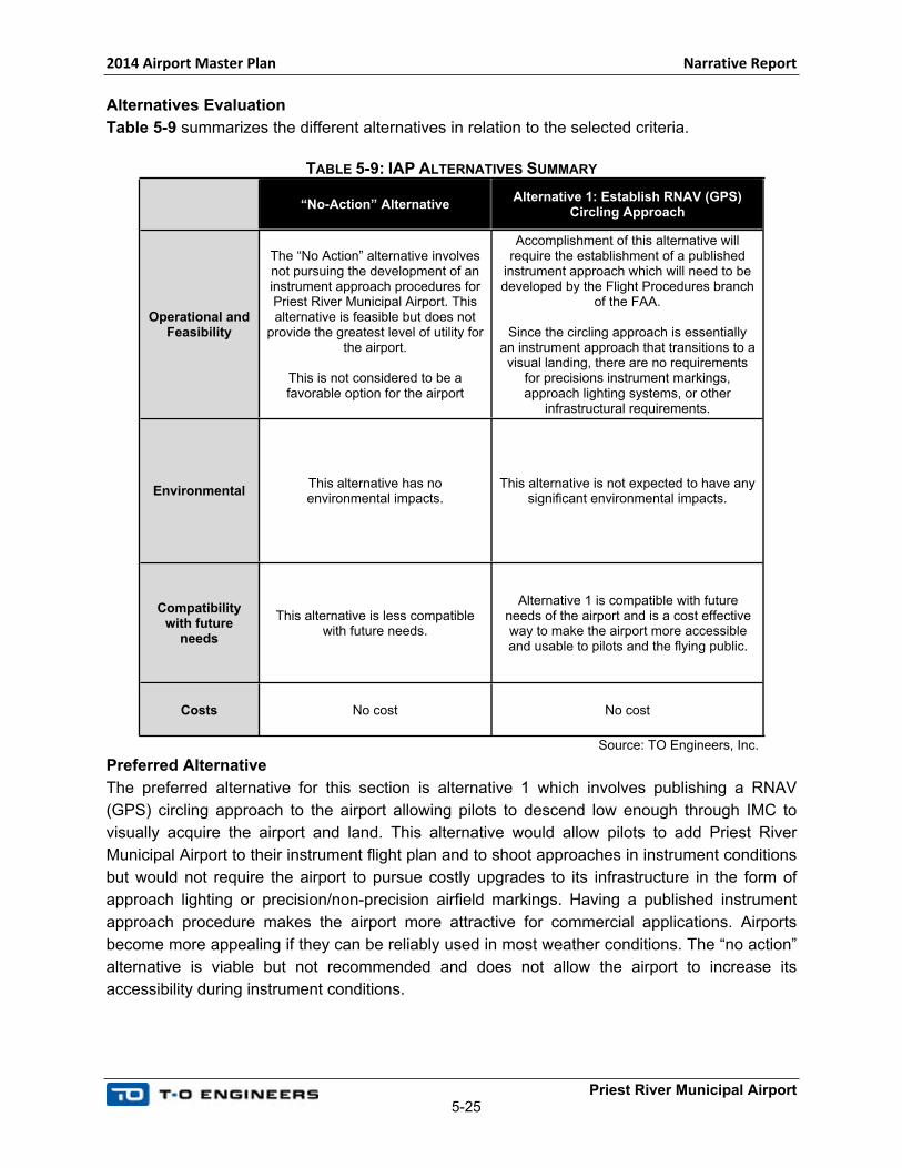
Table 5-9 summarizes the different alternatives in relation to the selected criteria.
TABLE 5-9: IAP ALTERNATIVES SUMMARY
“No-Action” AlternativeAlternative 1: Establish RNAV (GPS)
Circling Approach
Operational and Feasibility
The “No Action” alternative involves not pursuing the development of an instrument approach procedures for Priest River Municipal Airport. This alternative is feasible but does not
provide the greatest level of utility for the airport.
This is not considered to be a favorable option for the airport
Accomplishment of this alternative will require the establishment of a published
instrument approach which will need to be developed by the Flight Procedures branch
of the FAA.
Since the circling approach is essentially an instrument approach that transitions to a visual landing, there are no requirements
for precisions instrument markings, approach lighting systems, or other
infrastructural requirements.
EnvironmentalThis alternative has no environmental impacts.
This alternative is not expected to have any significant environmental impacts.
Compatibility with future
needs
This alternative is less compatible with future needs.
Alternative 1 is compatible with future needs of the airport and is a cost effective way to make the airport more accessible and usable to pilots and the flying public.
Costs No cost No cost
Source: TO Engineers, Inc.
Preferred Alternative
The preferred alternative for this section is alternative 1 which involves publishing a RNAV
(GPS) circling approach to the airport allowing pilots to descend low enough through IMC to
visually acquire the airport and land. This alternative would allow pilots to add Priest River
Municipal Airport to their instrument flight plan and to shoot approaches in instrument conditions
but would not require the airport to pursue costly upgrades to its infrastructure in the form of
approach lighting or precision/non-precision airfield markings. Having a published instrument
approach procedure makes the airport more attractive for commercial applications. Airports
become more appealing if they can be reliably used in most weather conditions. The “no action”
alternative is viable but not recommended and does not allow the airport to increase its
accessibility during instrument conditions.
2014 Airport Master Plan Narrative Report
Priest River Municipal Airport5-26
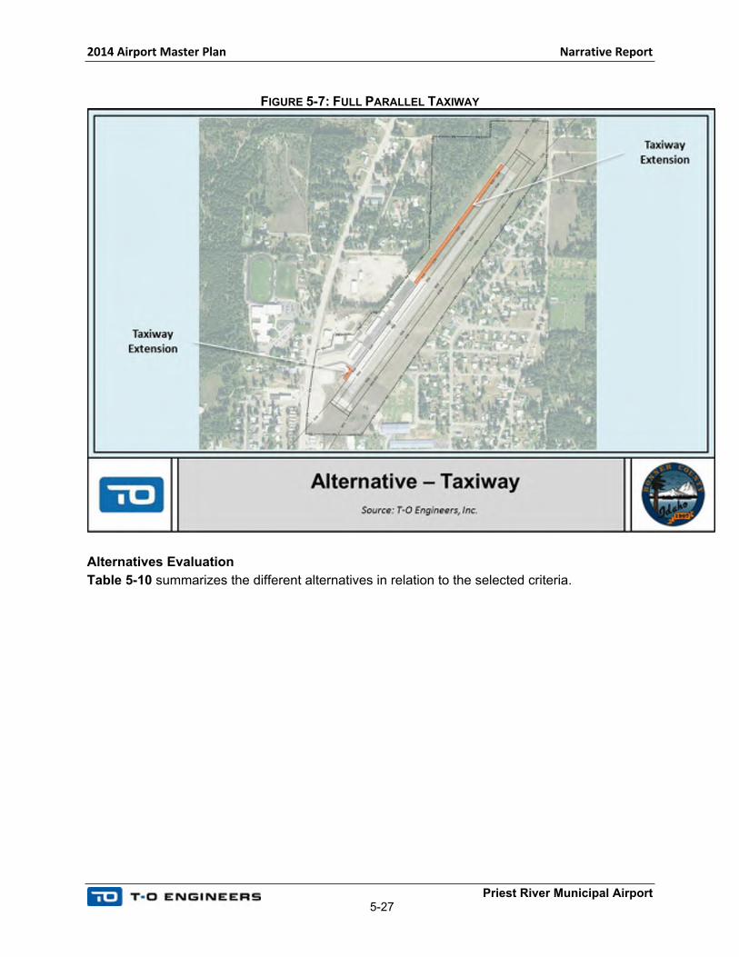
5.6.5 PARALLEL TAXIWAY
A full-length parallel taxiway would contribute to an increased level of safety at the airport. In
addition, a full-length parallel taxiway will be necessary to access future development on Parcel
G. The existing parallel taxiway centerline is locating at 150 feet from the existing runway
centerline and it meets B-I Small design standards. The preferred runway alternative shifts the
runway centerline 6 feet to the east, and the existing and extended parallel taxiway will be
located 156 feet from the runway centerline.
One alternative was developed:
Alternative 1: Full parallel taxiway
Following is a summary of the taxiway alternative.
No Action
A “No-action” alternative consists of maintaining the existing configuration. This alternative does
not reduce the need for back-taxi operations. In addition, without a full parallel taxiway, the only
access to the newly acquired Parcel G would be provided through back-taxi operations on the
runway. The goal of this planning study is to provide the County with options for necessary
improvements and future development. This alternative does not meet this goal, as it does not
provide a safe access to Parcel G.
Alternative 1: Full Parallel Taxiway
This alternative consists of a full parallel taxiway. The existing taxiway centerline would be
maintained at its location and extended to Runway 1/19 thresholds. This full parallel taxiway
would extend from the north side of the aircraft apron and would extend for a length determined
by whichever RPZ alternative is chosen. A small length of taxiway on the south side of the
apron would connect with a small paved run-up area adjacent to the approach end of Runway 1.
These taxiway additions are depicted in Figure 5-7. In order for the taxiway to reach the full
future end of pavement on the south end, the taxiway elevation would need to be raised by 4 to
6 feet in order to meet the runway’s grade. This places undue burden on the airport design and
is not realistically feasible. The estimated cost of this project is $415,000.
2014 Airport Master Plan Narrative Report
Priest River Municipal Airport5-27
FIGURE 5-7: FULL PARALLEL TAXIWAY
Alternatives Evaluation
Table 5-10 summarizes the different alternatives in relation to the selected criteria.

2014 Airport Master Plan Narrative Report
Priest River Municipal Airport5-28
TABLE 5-10: TAXIWAY ALTERNATIVES SUMMARY
“No-Action” Alternative Alternative 1: Full Parallel Taxiway
Operational and Feasibility
Does not reduce the need for back-taxi operations and does not provide safe access to Parcel G (the only access will be by back-
taxiing on the runway).
Contributes to an increased level of safety at the airport by reducing the need for back-taxi operations.
Environmental No additional environmental impacts.Remains entirely on airport property and does not require land acquisition. Impacts
areas in urban environment.
Feasibility Feasible as it does not necessitate any construction or action. Feasible without any impact on existing infrastructure.
Compatibility with future
needsNot compatible with future needs.
Compatible with future needs and provides an increased level of safety as it eliminates the need for back-taxi operations and provides a safe access to Parcel G.
Costs No additional costs. Costs Estimate: $415,000.
Source: T-O Engineers Inc.
Preferred Alternative
The Preferred Alternative is Alternative 1: Construction of a full-length parallel taxiway. This alternative will provide an increased level
of safety and eliminate the need for back-taxi operations. Additional environmental analysis will be required and it is expected a
Categorical Exclusion will meet the environmental requirements for this project. Taxiway extensions can usually be categorically
excluded if they only have on-airport impacts under paragraph 5-6.4e from FAA Order 1050.1F (construction, repair, or extension an
existing airport’s taxiway). Additional coordination with the Helena ADO will be necessary before construction.
This preferred alternative is contingent on other alternatives from this chapter including the RPZ preferred alternative. The runway
pavement is expected to increase in length by approximately 832 feet with extensions occurring on both ends. A total of roughly 2,763
feet of taxiway pavement would be required to meet the demands of the preferred alternatives in this chapter. The portion of future
parallel taxiway on the north side of the apron will be approximately 2,233 feet in length while the southern portion will only be 530 feet
long.

2014 Airport Master Plan Narrative Report
Priest River Municipal Airport5-29
5.6.6 WIND CONE AND SEGMENTED CIRCLE
The ROFA and OFZ for Runway 1/19 at Priest River Municipal Airport do not meet design
standards as they are impacted by the existing wind cone as well as an air relief valve. In
addition, the airport is not currently equipped with a segmented circle. To meet B-I Small design
standards, it is recommended to relocate the wind cone out of the ROFA and regrade around
the air relief valve. In addition, the installation of a segmented circle is recommended at the new
location of the lighted windcone.
A “No-action” alternative is not acceptable as the existing location of the wind cone does not
meet safety standards. Therefore, it must be relocated outside of the runway protection areas.
The air relief valve will be addressed when the runway is widened, and change in runway grade
at Runway 1 threshold will address this issue.
To relocate the wind cone outside of the ROFA and OFZ, and remain on airport property, the
wind cone and segmented circle would need to be relocated mid-field on the north side of the
runway, as depicted in Figure 5-8. The estimated cost for this project is $30,000.
FIGURE 5-8: WIND CONE RELOCATION
2014 Airport Master Plan Narrative Report
Priest River Municipal Airport5-30
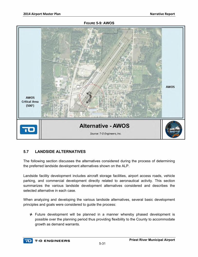
5.6.7 AUTOMATED WEATHER OBSERVING SYSTEM (AWOS)
As mentioned in Chapter 4, Facility Requirements, Automated Weather Observing Systems
(AWOS) provide real time weather information to pilots and contribute to enhanced safety.
However, Bonner County should keep in mind that AWOS equipment is expensive and the initial
costs, approximately $150,000, do not include annual maintenance requirements, which can
average $4,000 to $6,000 per year, not including additional unforeseeable maintenance repairs.
In accordance with FAA Order 6560.2B, Siting Criteria for Automated Weather Observing
Systems, the AWOS has a 500-foot radius critical area, which needs to be protected to provide
accurate wind and weather information.
Proactive planning recommends protecting areas for future development and a proposed
AWOS site is depicted on the ALP and in Figure 5-9. The proposed location is 380 feet from the
threshold of Runway 1 and 230 feet from the runway centerline. This location is out of the
preferred sitting area described in the FAA Order 6560.2B, Siting Criteria for Automated
Weather Observing Systems: 1,000 to 3,000 feet down runway from the threshold, and between
500 and 1,000 from the runway centerline. However, this location was deemed the most
suitable given the constrained environment of the airport. It remains on airport property and
minimizes the amount of buildings and obstructions in the critical area. Based on the proposed
location, the airport would need to secure an easement to limit new buildings heights in the
critical zone, and prevent the construction of additional buildings. If the County wants to pursue
the installation of an AWOS it is recommended that additional coordination be conducted with
the FAA.
2014 Airport Master Plan Narrative Report
Priest River Municipal Airport5-31
FIGURE 5-9: AWOS
5.7 LANDSIDE ALTERNATIVES
The following section discusses the alternatives considered during the process of determining
the preferred landside development alternatives shown on the ALP.
Landside facility development includes aircraft storage facilities, airport access roads, vehicle
parking, and commercial development directly related to aeronautical activity. This section
summarizes the various landside development alternatives considered and describes the
selected alternative in each case.
When analyzing and developing the various landside alternatives, several basic development
principles and goals were considered to guide the process:
Future development will be planned in a manner whereby phased development is
possible over the planning period thus providing flexibility to the County to accommodate
growth as demand warrants.
2014 Airport Master Plan Narrative Report
Priest River Municipal Airport5-32
The need for full build-out of the airport as depicted on the ALP drawing set is not
justified based on the aviation activity forecasts performed as part of this study.
However, recommendations have been developed based on a proactive planning
approach where space should be reserved and facilities will be built as demand
warrants.
Future development of the airport should be mindful of various aircraft and activity types:
o Uses such as helicopter traffic should be located in areas that ensure
compatibility with other surrounding aviation uses (due to potential of foreign
object debris (FOD) in particular).
o Orderly development of hangar areas ensuring compatibility with FAA design
standards based on current and anticipated aircraft use (i.e. aircraft design
groups)
Future development of the airport should be done in a manner that best optimizes
access to public infrastructure including:
o Vehicle/road access
o Utilities
o Available land/surrounding uses
Future development should take into consideration and be mindful of environmental
issues at the airport. In addition, future development should minimize potential effect on
the environment.
The existing general aviation apron area at Priest River Municipal Airport is divided into two
distinct areas and configured to accommodate a total of nine apron tie-down positions, with
space available for both based and transient aircraft. Historically, only a small percentage of
locally-based aircraft use ramp tie-down areas.
As identified in Chapter 4, Facilities Requirements, there is a no foreseeable shortfall of apron
area at the end of the 20-year planning period. However, plans have been developed based on
a proactive planning approach where space should be reserved and facilities will be built as
demand warrants. Bonner County should keep in mind that pavement is expensive to maintain
and that many of the recommendations are demand driven and should only be considered when
and if demand at the airport warrants.
Two areas were studied for development opportunities at Priest River Municipal Airport. These
areas are described as the Northside Development Area, which includes Parcel G and F, and
the Southside Development and are depicted in Figure 5-10. Priest River Municipal Airport
acquired Parcel G for future development and to limit encroachment of incompatible land uses
and development on land adjacent to the airport. In addition, the airport is currently in the
process of acquiring Parcel F using County funds only and no federal funds.

2014 Airport Master Plan Narrative Report
Priest River Municipal Airport5-33
FIGURE 5-10: DEVELOPMENT AREAS
No Action
A “No-action” alternative would consist in maintaining landside facilities at their current location
and not adding any new capacity. This is not considered as a viable alternative nor is it
desirable by the County. The goal of this planning study is to provide the County with options for
necessary improvements and for future development. A “No-action” alternative does not meet
this goal nor does it meet safety standards. However, the County should keep in mind that
pavement is expensive to maintain and that the development depicted on the ALP should only
be considered when demand warrants.
5.7.1 SOUTHSIDE DEVELOPMENT AREA
The area described as the Southside Development Area consists of the southern portion of the
existing airport property along taxilane B. Two alternatives were developed for this area and are
described hereafter. The two alternatives consist of hangars and a building to store snow
removal equipment. Following is a summary of each alternative.
2014 Airport Master Plan Narrative Report
Priest River Municipal Airport5-34
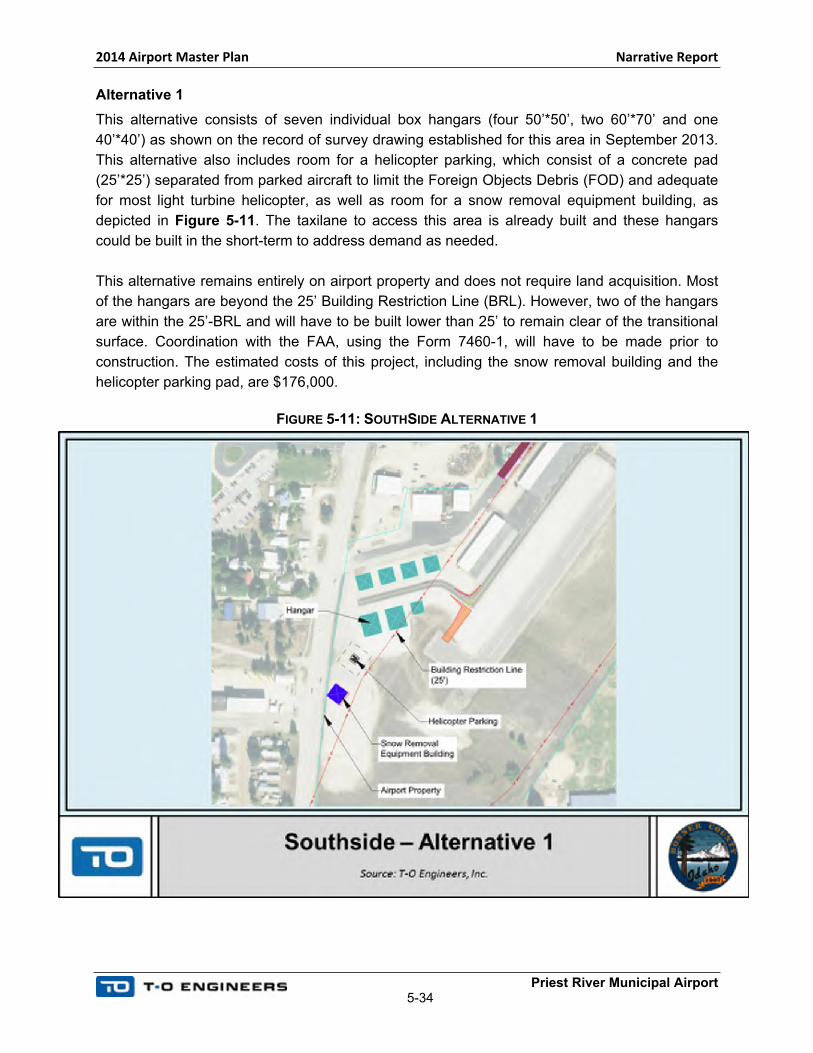
Alternative 1
This alternative consists of seven individual box hangars (four 50’*50’, two 60’*70’ and one
40’*40’) as shown on the record of survey drawing established for this area in September 2013.
This alternative also includes room for a helicopter parking, which consist of a concrete pad
(25’*25’) separated from parked aircraft to limit the Foreign Objects Debris (FOD) and adequate
for most light turbine helicopter, as well as room for a snow removal equipment building, as
depicted in Figure 5-11. The taxilane to access this area is already built and these hangars
could be built in the short-term to address demand as needed.
This alternative remains entirely on airport property and does not require land acquisition. Most
of the hangars are beyond the 25’ Building Restriction Line (BRL). However, two of the hangars
are within the 25’-BRL and will have to be built lower than 25’ to remain clear of the transitional
surface. Coordination with the FAA, using the Form 7460-1, will have to be made prior to
construction. The estimated costs of this project, including the snow removal building and the
helicopter parking pad, are $176,000.
FIGURE 5-11: SOUTHSIDE ALTERNATIVE 1
2014 Airport Master Plan Narrative Report
Priest River Municipal Airport5-35
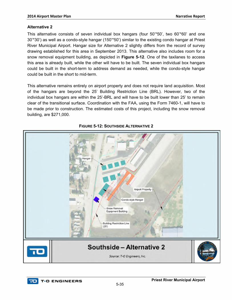
Alternative 2
This alternative consists of seven individual box hangars (four 50’*50’, two 60’*60’ and one
30’*30’) as well as a condo-style hangar (150’*50’) similar to the existing condo hangar at Priest
River Municipal Airport. Hangar size for Alternative 2 slightly differs from the record of survey
drawing established for this area in September 2013. This alternative also includes room for a
snow removal equipment building, as depicted in Figure 5-12. One of the taxilanes to access
this area is already built, while the other will have to be built. The seven individual box hangars
could be built in the short-term to address demand as needed, while the condo-style hangar
could be built in the short to mid-term.
This alternative remains entirely on airport property and does not require land acquisition. Most
of the hangars are beyond the 25’ Building Restriction Line (BRL). However, two of the
individual box hangars are within the 25’-BRL and will have to be built lower than 25’ to remain
clear of the transitional surface. Coordination with the FAA, using the Form 7460-1, will have to
be made prior to construction. The estimated costs of this project, including the snow removal
building, are $271,000.
FIGURE 5-12: SOUTHSIDE ALTERNATIVE 2

2014 Airport Master Plan Narrative Report
Priest River Municipal Airport5-36
Alternatives Evaluation
Table 5-11 summarizes the different alternatives in relation to the selected criteria.
TABLE 5-11: SOUTHSIDE ALTERNATIVES SUMMARY
Alternative 1 Alternative 2
Operational and Feasibility
Provide capacity to store existing and future based aircraft. Maintain an acceptable level of safety and designed to Aircraft Design Group I.
Hangars as shown on the record of survey drawing established for this area in September 2013. Technically feasible and could be developed
in the short to mid-term when demand warrants. A FAA form 7460-1 will have to be filled prior to any construction. Maximum height of two
hangars is limited by the transitional surface.
Provide capacity to store existing and future based aircraft. Maintain an acceptable level of safety and designed to Aircraft
Design Group I.
Hangars shown are slightly different from the record of survey drawing established for this area in September 2013. Technically feasible and could be developed in the short to mid-term when demand warrants. A FAA form 7460-1 will have to be filled prior to any construction. Maximum height of two hangars is limited by
the transitional surface.
Environmental
Impacts areas that have been previously disturbed in an urban and developed environment. Requires small amount of earthwork to build the hangars.
No major environmental impacts are foreseeable. Both alternatives impacts similar areas. Environmental coordination (Categorical Exclusion) will be necessary prior to construction and prior to any hangar development.
Compatibility with future needs
Provide aircraft hangars space, easily built in the short-term.
Costs Costs Estimate: $176,000. Costs Estimate: $271,000.
Source: TO Engineers Inc.
Preferred Alternative
The Preferred Alternative is a modified version of Alternative 1, as depicted in Section 5.7.3, Preferred Alternative. The revised
Alternative 1 removes the smaller hangar and relocates the helicopter parking pad in this area. The preferred alternative also relocates
the SRE building, it is the less expensive than Alternative 2, and provides appropriate box hangar space in the short-term. In addition,
it provides a convenient parking area for helicopters that could be developed in the short-term.
2014 Airport Master Plan Narrative Report
Priest River Municipal Airport5-37
The Preferred Alternative will consist of consists of six individual box hangars (four 50’*50’ and
two 60’*70’). The four smaller hangars are to be located along the north edge of Taxilane B
while the two slightly larger hangars will be located across the taxilane on the south side. A
proposed helicopter landing pad is located on the souths side of Taxilane B adjacent to the
aircraft hangar. As previously mentioned, the SRE facility is relocated to the west of the existing
aircraft apron behind the large aircraft hangars. Hangars in this area will provide additional
covered aircraft parking near the approach end of Runway 2 with direct access to the future full
length taxiway.
5.7.2 NORTHSIDE DEVELOPMENT AREA
The area described as the Northside Development Area consists of Parcels G and F.
Three alternatives were developed for this area and are described hereafter. The three
alternatives consist of hangars and aircraft parking aprons. In addition, the three alternatives
include development space for a FBO, a fuel island as well as a business development with
airside access. The three alternatives include a helicopter parking area, which allows parking
one helicopter separated from parked aircraft to limit the FOD. Several helicopter parking areas
were planned to provide options to the County. However, the preferred alternative, described in
Section 5.7.3, includes one helicopter parking pad only.
Parcel G requires a new access road and utility corridor, while Parcel F requires the extension
of the existing road and utilities. Further, access road to Parcel F requires the
demolition/relocation of the caretaker building located in the immediate vicinity of the existing
pilot’s lounge.
Space for a Business/Commercial development with airside access was reserved on Parcel G.
This area can be used by industries or manufacturers compatible with airport operations that
require an apron and taxilane access. FAA AIP participation is not expected for this
development.
The development of parcel F could occur in the short to mid-term, while the development of
parcel G could occur in the long-term. This area could be easily phased in several stages to
answer demand if and when needs warrant.
Following is a summary of each alternative.
2014 Airport Master Plan Narrative Report
Priest River Municipal Airport5-38
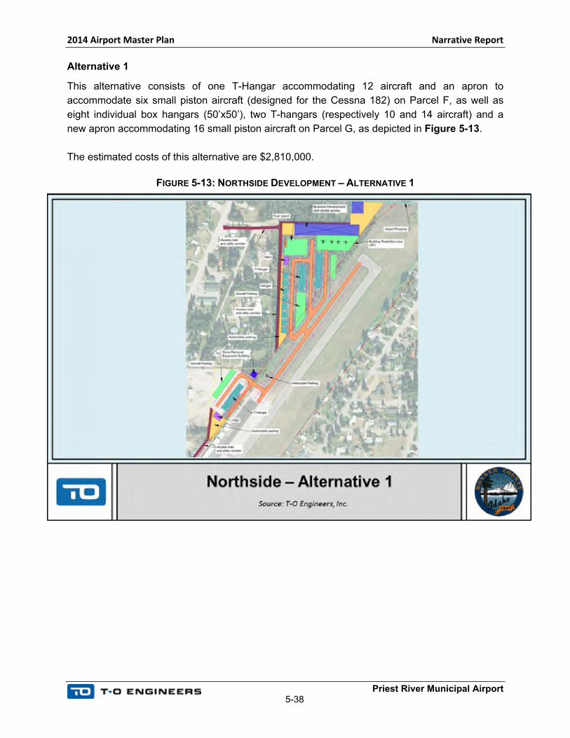
Alternative 1
This alternative consists of one T-Hangar accommodating 12 aircraft and an apron to
accommodate six small piston aircraft (designed for the Cessna 182) on Parcel F, as well as
eight individual box hangars (50’x50’), two T-hangars (respectively 10 and 14 aircraft) and a
new apron accommodating 16 small piston aircraft on Parcel G, as depicted in Figure 5-13.
The estimated costs of this alternative are $2,810,000.
FIGURE 5-13: NORTHSIDE DEVELOPMENT – ALTERNATIVE 1
2014 Airport Master Plan Narrative Report
Priest River Municipal Airport5-39
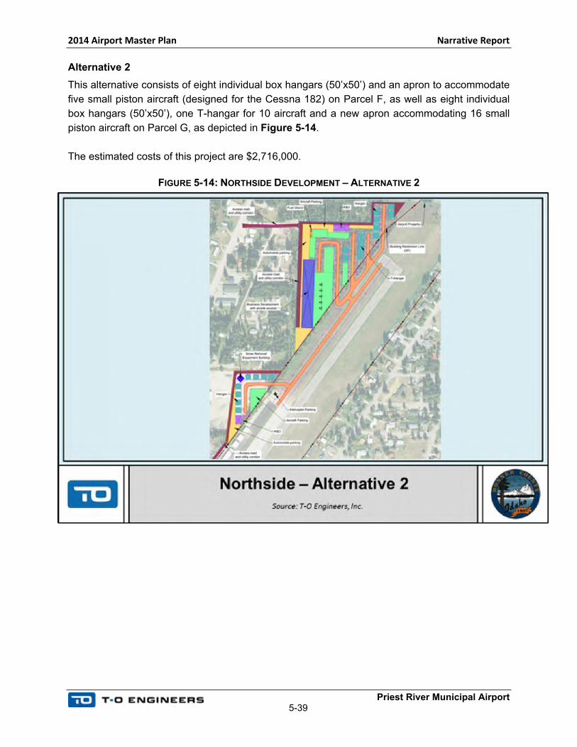
Alternative 2
This alternative consists of eight individual box hangars (50’x50’) and an apron to accommodate
five small piston aircraft (designed for the Cessna 182) on Parcel F, as well as eight individual
box hangars (50’x50’), one T-hangar for 10 aircraft and a new apron accommodating 16 small
piston aircraft on Parcel G, as depicted in Figure 5-14.
The estimated costs of this project are $2,716,000.
FIGURE 5-14: NORTHSIDE DEVELOPMENT – ALTERNATIVE 2

2014 Airport Master Plan Narrative Report
Priest River Municipal Airport5-40
Alternative 3
This alternative consists of five individual box hangars (50’x50’) and an apron to accommodate
seven small piston aircraft (designed for the Cessna 182) on Parcel F, as well as eight individual
box hangars (50’x50’), one T-hangar for 16 aircraft and a new apron accommodating 23 small
piston aircraft on Parcel G, as depicted in Figure 5-15.
The estimated costs of this project are $2,922,000.
FIGURE 5-15: NORTHSIDE DEVELOPMENT – ALTERNATIVE 3
Alternatives Evaluation
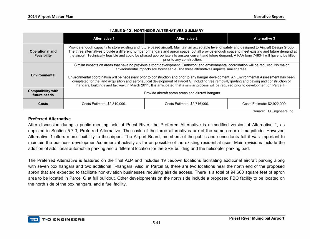
Table 5-12 summarizes the different alternatives in relation to the selected criteria.
2014 Airport Master Plan Narrative Report
Priest River Municipal Airport5-41
TABLE 5-12: NORTHSIDE ALTERNATIVES SUMMARY
Alternative 1 Alternative 2 Alternative 3
Operational and Feasibility
Provide enough capacity to store existing and future based aircraft. Maintain an acceptable level of safety and designed to Aircraft Design Group I. The three alternatives provide a different number of hangars and apron space, but all provide enough space to meet existing and future demand at the airport. Technically feasible and could be phased appropriately to answer current and future demand. A FAA form 7460-1 will have to be filled
prior to any construction.
Environmental
Similar impacts on areas that have no previous airport development. Earthwork and environmental coordination will be required. No major environmental impacts are foreseeable. The three alternatives impacts similar areas.
Environmental coordination will be necessary prior to construction and prior to any hangar development. An Environmental Assessment has been completed for the land acquisition and aeronautical development of Parcel G, including tree removal, grading and paving and construction of
hangars, buildings and taxiway, in March 2011. It is anticipated that a similar process will be required prior to development on Parcel F.
Compatibility with future needs
Provide aircraft apron areas and aircraft hangars.
Costs Costs Estimate: $2,810,000. Costs Estimate: $2,716,000. Costs Estimate: $2,922,000.
Source: TO Engineers Inc.
Preferred Alternative
After discussion during a public meeting held at Priest River, the Preferred Alternative is a modified version of Alternative 1, as
depicted in Section 5.7.3, Preferred Alternative. The costs of the three alternatives are of the same order of magnitude. However,
Alternative 1 offers more flexibility to the airport. The Airport Board, members of the public and consultants felt it was important to
maintain the business development/commercial activity as far as possible of the existing residential uses. Main revisions include the
addition of additional automobile parking and a different location for the SRE building and the helicopter parking pad.
The Preferred Alternative is featured on the final ALP and includes 19 tiedown locations facilitating additional aircraft parking along
with seven box hangars and two additional T-hangars. Also, in Parcel G, there are two locations near the north end of the proposed
apron that are expected to facilitate non-aviation businesses requiring airside access. There is a total of 94,600 square feet of apron
area to be located in Parcel G at full buildout. Other developments on the north side include a proposed FBO facility to be located on
the north side of the box hangars, and a fuel facility.

2014 Airport Master Plan Narrative Report
Priest River Municipal Airport 5-42
5.7.3 PREFERRED ALTERNATIVE
The preferred alternative combines a revised version of the Southside Alternative 1 and a
revised version of the Northside Alternative 1. It is depicted in Figure 5-16 and on the ALP.
Main revisions include the addition of additional automobile parking, and a different location for
the SRE building and helicopter parking pad.
This alternative could be phased appropriately, and such phasing will be addressed in Chapter
6, Development Plan/Financial Overview. Bonner County should keep in mind that such a
development is not fully justified at the moment based on existing and foreseeable traffic at the
airport. In addition, pavement is expensive to maintain and should be only built as necessary,
when demand warrants
This Alternative includes space for a commercial or business facility with on-airport access.
However, this alternative is flexible and would allow easy expansion of the taxilane and apron to
add additional hangars, if no commercial development occurs on airport property. As previously
mentioned, FAA AIP funds are only available to fund infrastructures that are exclusively used by
the airport. If a business wants to operate on Parcel G, improvements to utilities such as water,
sewer and electrical as well as paving will have to be funded by the business or by using local
or private funds. In addition, AIP funding is only available for one access road. Therefore, local
funds will have to be used to provide an access road to Parcels F and G.
The Preferred Alternative for landside development, including all three locations along the
airfield includes 14 box hangars, 3 T-hangars, 20+ tiedown spaces, 2 fuel facilities, 2 FBO
facilities, 1 helipad, 5 apron areas with supporting taxilanes, 1 SRE facility, and 3 vehicle
parking areas. As mentioned previously, full buildout of these facilities is not expected and
development should be pursued at a rate matching the increase of demand for services and
facilities at the airport. The Preferred Alternative provides ample options and opportunities for
the airport to pursue over the 20-year planning horizon.
The total cost estimate in 2015 dollars for this alternative is approximately $2,810,000. It is
expected an Environmental Assessment will be necessary to acquire and develop Parcel F. An
Environmental Assessment has been completed for the land acquisition and aeronautical
development of Parcel G, including tree removal, grading and paving and construction of hangar
buildings and taxiway, in March 2011. As environmental assessments are assumed to be valid
for a period of three years, coordination with the Helena ADO will be necessary to reevaluate
the adequacy and validity of the environmental assessment before actual construction.
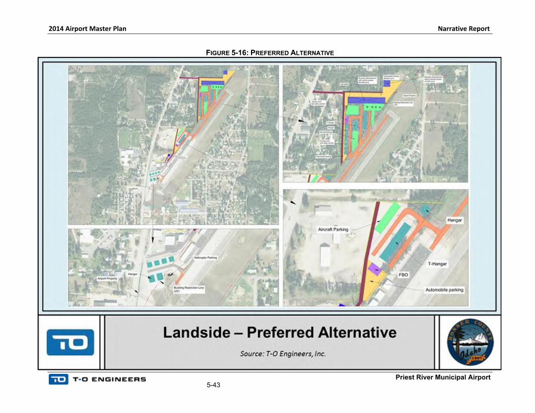
2014 Airport Master Plan Narrative Report
Priest River Municipal Airport5-43
FIGURE 5-16: PREFERRED ALTERNATIVE
2014 Airport Master Plan Narrative Report
Priest River Municipal Airport5-44
5.7.4 ACCESS ROAD AND AUTOMOBILE PARKING
Parcels F and G currently do not have any access roads. In addition, Parcel G is not currently
served by any existing utilities. Access roads and automobile parking were developed based on
the Preferred Alternative and are depicted in Figure 5-17. In addition, utilities extension should
be planned and a utilities corridor should be installed along the road.
Parking areas were developed in the immediate vicinity of the apron and future FBO to provide
convenient automobile parking to the airport’s users.
No Action
The “No-action” alternative consists of doing nothing and not providing access or utilities to
parcel F and G. This is not considered as a viable alternative nor is it desirable by the County.
The goal of this planning study is to provide the County with options for necessary
improvements and for future development. The “No-action” alternative does not meet this goal.
Alternative 1
This alternative includes construction of up to three vehicle parking areas with the largest
located on the north side of Parcel G which is intended to support future non-aviation
commercial development. The other two parking areas are located south of the box hangars in
Parcel G and near the existing apron. A proposed access roadway joins Highway 57 and runs
east/west to serve the future parking areas and non-aviation development areas with a leg
breaking to the south serving the 7 box hangers and FBO facility located in Parcel G. A second
roadway is a proposed extension of an existing access road leading to the future SRE facility
and future apron expansion area west of the existing apron.
Alternative 1 was developed for the automobile parking, road and utilities extension. It was
based on the preferred airside and landside alternatives, as depicted in Figure 5-17.
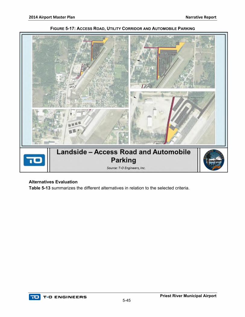
2014 Airport Master Plan Narrative Report
Priest River Municipal Airport5-45
FIGURE 5-17: ACCESS ROAD, UTILITY CORRIDOR AND AUTOMOBILE PARKING
Alternatives Evaluation
Table 5-13 summarizes the different alternatives in relation to the selected criteria.

2014 Airport Master Plan Narrative Report
Priest River Municipal Airport5-46
Alternatives Evaluation
TABLE 5-13: ALTERNATIVES SUMMARY
“No-Action” Alternative Alternative 1
OperationalDoes not allow for access and utilities to Parcel F and G. Feasible but not recommended as it does not allow
for additional airport development.
Meets operational demand at the airport and will provide an access road and utility corridor to Parcels F and G. Technically feasible and could be phased appropriately to answer current and future demand.
EnvironmentalA “No-Action” Alternative has no additional
environmental impacts.
Impacts areas that have no previous airport development. Earthwork and environmental coordination will be required, but no major
environmental impacts are foreseeable.
Environmental coordination will be necessary prior to construction and development. An Environmental Assessment has been completed for
the land acquisition and aeronautical development of Parcel G, including tree removal, grading and paving and construction of hangar
buildings and taxiway, in March 2011. It is anticipated that a similar process will be required prior to development on Parcel F.
Compatibility with future needs
Constraints the airport layout and does not allow development on Parcel F or G.
Compatible with future needs and provides access to Parcel F and G.
Costs No additional costs. Costs Estimate: $515,000.
Source: TO Engineers Inc.
Preferred Alternative
Alternative 1 is the preferred Road Relocation Alternative. It should be noted that FAA AIP funding will not be available for these
access roads, as AIP funds can only be used for one access road. If a business wants to operate on Parcel G, access road paving
may be totally or partially funded by the business.
2014 Airport Master Plan Narrative Report
Priest River Municipal Airport5-47
5.8 SUMMARY OF CONCLUSIONS
Following is a summary of conclusions. It is understood that the need for full build-out of the
airport as depicted on the ALP drawing set is unlikely and not justified based on the aviation
activity forecasts performed as part of this study. However, the various alternatives and
recommendations have been developed based on a proactive planning approach whereby long-
term guidance has been presented to the County to assist them in facilitating logical and orderly
development over the planning period.
5.8.1 AIRSIDE ALTERNATIVES
B-I Small Standards
To meet B-I Small design standards, Runway 1/19 needs to be widened, the wind cone needs
to be relocated out of the ROFA and the obstructions in the RPZs need to be addressed.
Addressing the RPZs will begin with displacing the runway thresholds on Runway ends 1-19
578 feet and 538 feet respectively. Displacing the runway thresholds and implementing declared
distances is necessary to mitigate obstructions to the RPZs.
In order to return usable runway length to the airport, pavement extensions on both runway
ends are going to be constructed in two phases. The first phase involves lengthening the 1 end
by 236 feet and 19 by 221 feet. The second phase will further lengthen the pavement on the
end of Runway 19 by an additional 375 feet. During the second phase, the threshold for
Runway 19 will be relocated 138 feet closer to the runway end assuming that the threshold
siting surfaces are clear of airspace obstructions and all properties within the RPZ have been
acquired by the airport and cleared of developments and incompatible land uses.
Runway 1/19 centerline will be shifted 6 feet to the east in response to the runway being
widened by 12 feet. This alternative includes removal of existing pavement on the overall length
of the runway, new pavement as well as new Medium Intensity Runway Lights (MIRL), Runway
End Identifier Lights (REIL) on both ends, Precision Approach Path Indicators (PAPI) on the
Runway 1 end, and electrical wiring. This alternative also includes grading of the RSA after the
runway ends to meet RSA slope design criteria wich will also mitigate the relief valve currently
obstructing the RSA.
Obstructions and Approach Surfaces
In order to facilitate the RPZ preferred alternative and for the airport to become compliant with federal criteria, it is necessary that the current obstructions to airspace, particularly those obstructing TSS, are sufficiently mitigated.
2014 Airport Master Plan Narrative Report
Priest River Municipal Airport5-48
Mitigation of existing obstacles can be accomplished by first acquiring avigation easement and properties where the obstructions are located. This allows the airport to have access to the obstacles and the legal precedence to mitigate them. In most cases the obstacles are trees or tree clusters and they will be removed. In other cases, methods of mitigation such as obstruction marking or lighting may be adequate.
In order for the airport to maximize its utility, become compliant with federal criteria, and pursue full implementation of the other preferred alternatives in this chapter, the mitigation of obstructions to critical airspace is essential.
Instrument Approach Procedure
Instrument approach procedures make airports more reliable and accessible to the flying public. As a result, they can greatly increase an airport’s capacity yielding economic benefits for the communities served by the airport.
An opportunity exists for Priest River Municipal Airport to seek development of a published instrument approach procedures, specifically a RNAV (GPS) circling approach, without having to pursue costly and infeasible upgrades to the airport infrastructure and surrounding lands. The implementation of this procedure would greatly benefit the airport.
Parallel Taxiway
The construction of a nearly full parallel taxiway at Priest River Municipal Airport will improve the
overall level of safety at the airport and limit the need for back-taxi operations. In addition, this
taxiway will provide access to Parcel G. Construction should be phased as needed to provide
access to Parcel G, when demand warrants. In order for a taxiway to reach the full future end of
pavement on the south end, the taxiway would need to be raised by 4 to 6 feet in order to meet
the runway’s grade. This places undue burden on the airport design and is not realistically
feasible. Phasing will be addressed in Chapter 6, Development plan/Financial Overview.
Other Airside Facilities
The existing wind cone is in the B-I Small standards protection areas. The existing wind cone
needs to be relocated outside the ROFA and OFZ and a segmented circle must be constructed
around the new location. A proposed location was analyzed, approximately 60 feet east of the
existing position. This relocation does not require any land acquisition as the wind cone will
remain on airport property.
A proposed location for an AWOS was analyzed and depicted on the ALP. The AWOS has a
500-feet radius critical area. The proposed location is 380 feet from the threshold of Runway 1
and 230 feet from the runway centerline. This location is out of the preferred siting area
described in the FAA Order 6560.2B, Siting Criteria for Automated Weather Observing Systems:
Based on the proposed location, the airport would need to secure an easement to limit new
building height. If the County wants to pursue the installation of an AWOS at Priest River
Municipal Airport it is recommended that additional coordination be conducted with the FAA.
2014 Airport Master Plan Narrative Report
Priest River Municipal Airport5-49
5.8.2 LANDSIDE ALTERNATIVES
Alternatives for landside development at Priest River Municipal Airport focus on a variety of
hangars, taxilanes, and apron layouts. These development alternatives focus on two areas: the
Southside, and the Northside. The Southside consists of on-airport development alternative,
and the Northside consists of development on Parcels G and F. Parcel G has already been
acquired, while the airport is currently in the process of acquiring Parcel F. The preferred
alternatives for these two areas are summarized below.
Southside Development Area
This alternative is planned along an existing taxilane. Therefore, it allows for hangar
construction in the short-term without any major investment by the airport. Hangar construction
can be phased appropriately when demand warrants. However, this alternative does not provide
aircraft apron space. This area is preferred in the short-term over other areas around the airport
because of its convenience to build new hangars without any additional cost to the airport. The
existing Taxilane ‘B’ will be connected to the future parallel taxiway and provide easy access to
the runway. The Southside Development Area is projected to accommodate up to six box
hangars and a helipad.
Northside Development Area
The Northside Development area is composed of Parcel G and Parcel F. Both areas provide
siting for hangars, aprons,tie-downs, vehicle parking, fuel facilities, and FBOs. Parcel G has
already been acquired alternative and the airport is in the process of acquiring Parcel F. No
other land acquisition will be necessary. Parcel G provides for the ultimate development at
Priest River Municipal Airport, while Parcel F could be phased in the mid-term. This
development area will be built only if and when demand warrants. This alternative offers the
airport significant flexibility in terms of opening development opportunities for both aviation and
non-aviation uses. Although air traffic demand may not warrant full buildout over the next 20
years, having this alternative in place will allow the airport to be dynamic when addressing
future airport demands.
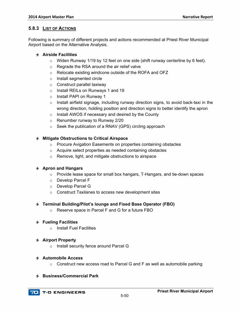
2014 Airport Master Plan Narrative Report
Priest River Municipal Airport5-50
5.8.3 LIST OF ACTIONS
Following is summary of different projects and actions recommended at Priest River Municipal Airport based on the Alternative Analysis.
Airside Facilities
o Widen Runway 1/19 by 12 feet on one side (shift runway centerline by 6 feet).
o Regrade the RSA around the air relief valve
o Relocate existing windcone outside of the ROFA and OFZ
o Install segmented circle
o Construct parallel taxiway
o Install REILs on Runways 1 and 19
o Install PAPI on Runway 1
o Install airfield signage, including runway direction signs, to avoid back-taxi in the
wrong direction, holding position and direction signs to better identify the apron
o Install AWOS if necessary and desired by the County
o Renumber runway to Runway 2/20
o Seek the publication of a RNAV (GPS) circling approach
Mitigate Obstructions to Critical Airspace
o Procure Avigation Easements on properties containing obstacles
o Acquire select properties as needed containing obstacles
o Remove, light, and mitigate obstructions to airspace
Apron and Hangars
o Provide lease space for small box hangars, T-Hangars, and tie-down spaces
o Develop Parcel F
o Develop Parcel G
o Construct Taxilanes to access new development sites
Terminal Building/Pilot’s lounge and Fixed Base Operator (FBO)
o Reserve space in Parcel F and G for a future FBO
Fueling Facilities
o Install Fuel Facilities
Airport Property
o Install security fence around Parcel G
Automobile Access
o Construct new access road to Parcel G and F as well as automobile parking
Business/Commercial Park

2014 Airport Master Plan Narrative Report
Priest River Municipal Airport5-51
o Reserve space on airport property, on Parcel G for Business/Commercial
activities
5.9 ENVIRONMENTAL CONSIDERATIONS AND PERMITTING PRIOR TO DEVELOPMENT
A detailed overview on the environmental setting and potential environmental consequences at
Priest River Municipal Airport is provided in Appendix A, Environmental Overview for the Priest
River Municipal Airport.
More detailed environmental analysis will be required before proceeding with actual
construction. This should include coordination with agencies such as FAA, United States Army
Corps of Engineers, U.S. Fish and Wildlife Service, State and local health agencies, State
Historical Preservation Office and others as deemed necessary.
A detailed environment analysis will be required for most of the projects and may also be
required if projects impact farmlands. In addition, before any hangar construction, the form
7460-1, Notice of Proposed Construction or Alteration, must be submitted to the FAA and an
environmental clearance for development must be obtained.
It is anticipated that an Environmental Assessment will be necessary for the runway widening,
new runway lights and obstacles mitigation. A significant amount of trees will have to be cut or
topped, and this will have to be addressed in the Environmental Assessment.
Further, an Environmental Assessment has been completed for the land acquisition and
aeronautical development of Parcel G, including tree removal, grading and paving and
construction of hangar buildings and taxiway, in March 2011. A Finding of No Significant Impact
(FONSI) has been emitted by the FAA on March 28, 2011. Environmental Assessments are
assumed to be valid for a period of three years. Coordination with the Helena ADO will be
necessary to reevaluate the adequacy and validity of the environmental assessment before
actual construction.
In addition, an Environmental Assessment for the land acquisition and development of Parcel F
will also be required.
A determination on necessary action will be completed at the appropriate time to best facilitate
the proposed project(s). With the exception of the wind cone relocation and runway shift, the
majority of new development at the airport is expected to be demand driven and will only be
considered when, and if, demand at the airport warrants.
2014 Airport Master Plan Narrative Report
Priest River Municipal Airport5-52
5.9.1 CLEAN WATER ACT PERMITTING
Construction activities that disturb one acre or more of land (including clearing, grading, and
excavating) require coverage by a National Pollutant Discharge Elimination System (NPDES)
storm water permit. Future projects at Priest River Municipal Airport that impact more than 1
acre of land, will require a NPDES permit. In addition, a Storm Water Pollution Prevention Plan
(SWPPP) will be required to describe the site controls.
5.9.2 LOCAL BUILDING PERMIT
A building permit has to be obtained, prior to any construction, throughout the City of Priest
River.