Embed Size (px)
Citation preview
{W5962073.1}
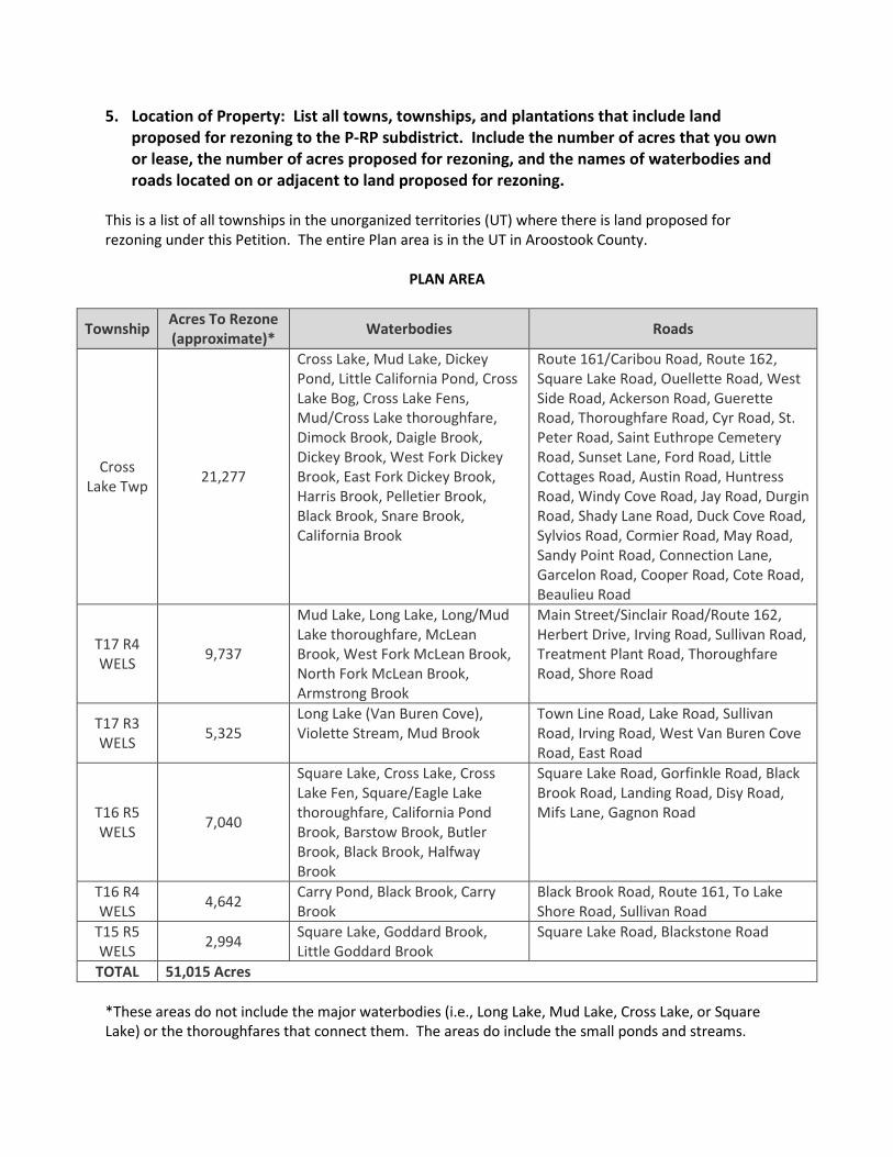
5. Location of Property: List all towns, townships, and plantations that include land proposed for rezoning to the P-RP subdistrict. Include the number of acres that you own or lease, the number of acres proposed for rezoning, and the names of waterbodies and roads located on or adjacent to land proposed for rezoning.
This is a list of all townships in the unorganized territories (UT) where there is land proposed for rezoning under this Petition. The entire Plan area is in the UT in Aroostook County.
PLAN AREA
Township Acres To Rezone (approximate)* Waterbodies Roads
Cross Lake Twp 21,277
Cross Lake, Mud Lake, Dickey Pond, Little California Pond, Cross Lake Bog, Cross Lake Fens, Mud/Cross Lake thoroughfare, Dimock Brook, Daigle Brook, Dickey Brook, West Fork Dickey Brook, East Fork Dickey Brook, Harris Brook, Pelletier Brook, Black Brook, Snare Brook, California Brook
Route 161/Caribou Road, Route 162, Square Lake Road, Ouellette Road, West Side Road, Ackerson Road, Guerette Road, Thoroughfare Road, Cyr Road, St. Peter Road, Saint Euthrope Cemetery Road, Sunset Lane, Ford Road, Little Cottages Road, Austin Road, Huntress Road, Windy Cove Road, Jay Road, Durgin Road, Shady Lane Road, Duck Cove Road, Sylvios Road, Cormier Road, May Road, Sandy Point Road, Connection Lane, Garcelon Road, Cooper Road, Cote Road, Beaulieu Road
T17 R4 WELS 9,737
Mud Lake, Long Lake, Long/Mud Lake thoroughfare, McLean Brook, West Fork McLean Brook, North Fork McLean Brook, Armstrong Brook
Main Street/Sinclair Road/Route 162, Herbert Drive, Irving Road, Sullivan Road, Treatment Plant Road, Thoroughfare Road, Shore Road
T17 R3 WELS 5,325
Long Lake (Van Buren Cove), Violette Stream, Mud Brook
Town Line Road, Lake Road, Sullivan Road, Irving Road, West Van Buren Cove Road, East Road
T16 R5 WELS 7,040
Square Lake, Cross Lake, Cross Lake Fen, Square/Eagle Lake thoroughfare, California Pond Brook, Barstow Brook, Butler Brook, Black Brook, Halfway Brook
Square Lake Road, Gorfinkle Road, Black Brook Road, Landing Road, Disy Road, Mifs Lane, Gagnon Road
T16 R4 WELS 4,642 Carry Pond, Black Brook, Carry
Brook Black Brook Road, Route 161, To Lake Shore Road, Sullivan Road
T15 R5 WELS 2,994 Square Lake, Goddard Brook,
Little Goddard Brook Square Lake Road, Blackstone Road
TOTAL 51,015 Acres *These areas do not include the major waterbodies (i.e., Long Lake, Mud Lake, Cross Lake, or Square Lake) or the thoroughfares that connect them. The areas do include the small ponds and streams.

NOTICE OF FILING
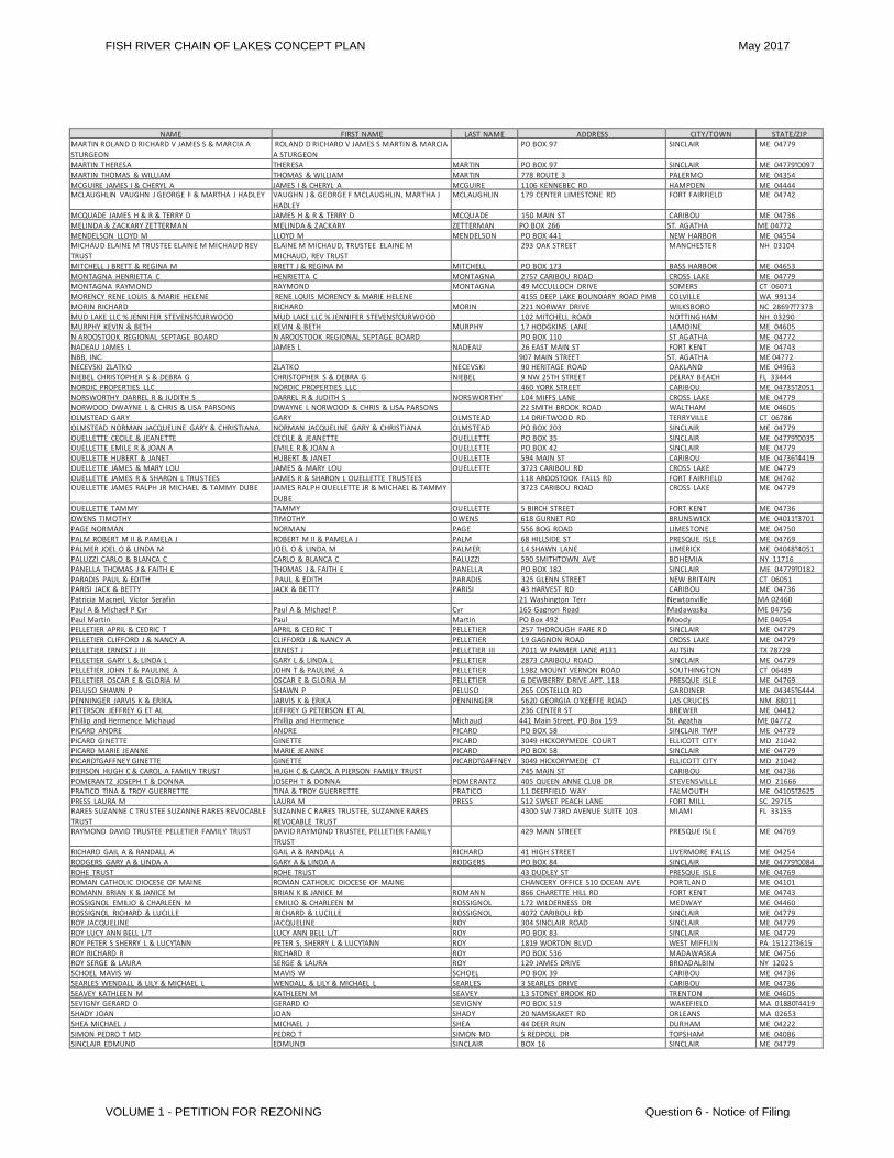
Irving provided public notice of this filing by publishing notice in the Bangor Daily News and St. John Valley Times on December 24, 2014, and by mailing notice via registered mail on December 24, 2014, to persons owning or leasing land within 1,000 feet of the Plan Area and other specified officials, as shown in the following tables.
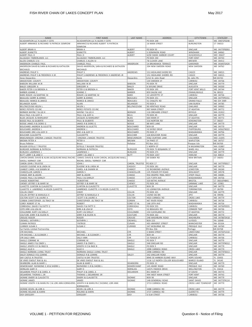
NAME FIRST NAME LAST NAME ADDRESS CITY/TOWN STATE/ZIP ACADIANͲSON LLC % ALEXIS F COTE ACADIANͲSON LLC % ALEXIS F COTE PO BOX 248 SACO ME 04072Ͳ0248 ALBERT ARMANCE & RICHARD % PATRICIA SEMROW ARMANCE & RICHARD ALBERT % PATRICIA
SEMROW 16 MAIN STREET BURLINGTON CT 06013
ALBERT BRIAN A BRIAN A ALBERT PO BOX 93 SINCLAIR ME 04779Ͳ0093 ALBERT JEANETTE JEANETTE ALBERT 5 DOMINION ROAD WINDHAM ME 04062 ALBERT PAUL O PAUL O ALBERT 6250 SWAN HARBOR COURT HUGHESVILLE MD 20637 ALLAGASH TIMBERLANDS LLC ALLAGASH TIMBERLANDS LLC PO BOX 240 FORT KENT ME 04743 ALLEN CHARLES S IV CHARLES S ALLEN IV 78 CLOVER LANE BREWER ME 04412 ANDERSON CHARLES PAUL CHARLES PAUL ANDERSON 14 BRUNSWICK TERRACE GARDINER ME 04345Ͳ2429 ANDERSON DAVID & SARA & RICHARD & KATHLEEN MICHAUD
DAVID ANDERSON, SARA & RICHARD & KATHLEEN MICHAUD 204 NEW SWEDEN ROAD NEW SWEDEN ME 04762
ANDREWS PHILIP S PHILIP S ANDREWS 151 HIGHLAND SHORE RD CASCO ME 04015 ANDREWS PHILIP S & FREDERICK H JR PHILIP S ANDREWS & FREDERICK H ANDREWS JR 151 HIGHLAND SHORES RD CASCO ME 04015 Anne Desjardins Anne Desjardins 1212 St. John Road St. John Plt. ME 04743 AROOSTOOK COUNTY AROOSTOOK COUNTY 144 SWEDEN ST CARIBOU ME 04736 BABSON WILLIAM W JR WILLIAM W JR BABSON PO BOX 79 SINCLAIR ME 04779 BAILEY GREGORY A GREGORY A BAILEY 6 SKYLINE DRIVE AUGUSTA ME 04330 BAKER PETER G & BRENDA A PETER G & BRENDA A BAKER PO BOX 195 FORT KENT MILLS ME 04744 BARBER JEANNE C JEANNE C BARBER 859 SALEM AVE FRANKLINVILLE NJ 08322 BARD ROGER J & MARTINE M ROGER J & MARTINE M BARD 22 LAFAYETTE ST CARIBOU ME 04736 BEAULIEU GERRY & JENNIE GERRY & JENNIE BEAULIEU PO BOX 151 SINCLAIR ME 04779Ͳ0151 BEAULIEU MARCO & JANICE MARCO & JANICE BEAULIEU 51 CHALETS RD GRAND FALLS NB E3Y 3W9 BELANGER ALAIN ALAIN BELANGER PO BOX 6 VAN BUREN ME 04785 BELLͲNECEVSKI HELEN L HELEN L BELLͲNECEVSKI 90 HERITAGE ROAD OAKLAND ME 04963 BERCE POTATO CO INC BERCE POTATO CO INC 907 MAIN STREET ST AGATHA ME 04772 BERNIER WAYNE T & LEE K WAYNE T & LEE K BERNIER 118 ORCHARD STREET BYFIELD MA 01922 BILLS PAUL H & JUDY A PAUL H & JUDY A BILLS PO BOX 49 SINCLAIR ME 04779 BLAIS JACQUES & MARGARET JACQUES & MARGARET BLAIS 664 MAIN ST ST AGATHA ME 04772 BOSSE PAUL & GILBERTE PAUL & GILBERTE BOSSE 316 NORTON RD KENSINGTON CT 06037 BOSSIE JAMES R & DORIS G JAMES R & DORIS G BOSSIE 88 MIFS LANE SINCLAIR ME 04779 BOUCHARD ANDREW & JULIETTE ANDREW & JULIETTE BOUCHARD BOX 69 SINCLAIR ME 04779 BOUCHARD ANDREW J ANDREW J BOUCHARD 10 SKYBO DRIVE PHIPPSBURG ME 04562Ͳ4022 BOUCHARD ERIC A & JUDY D ERIC A & JUDY D BOUCHARD PO BOX 27 MADAWASKA ME 04756 BOUCHER CLAUDETTE CLAUDETTE BOUCHER 226 BOUCHER ROAD SINCLAIR ME 04779 BRAEUNINGER VIRGINIA L MAGEE TRUSTEE VIRGINIA L MAGEE TRUSTEE BRAEUNINGER 9362 OURTIME LANE COLUMBIA MD 21045 BROWN PETER A PETER A BROWN 34 PINES ST MAPLETON ME 04757 Bruce Pelletier Bruce Pelletier PO Box 1411 Presque Isle ME 04769 BULGER ESTELLE T TRUSTEE ESTELLE T BULGER TRUSTEE 1 NORTH ST N WILMINGTON MA 01887 BURGHER NORMAN & PATRICIA NORMAN & PATRICIA BURGHER PO BOX 75 BENJAMIN ST MARS HILL ME 04758 BURLOCK LAWRENCE J LAWRENCE J BURLOCK PO BOX 275 SINCLAIR ME 04779 BUTT LARRY S & JANE V LARRY S & JANE V BUTT PO BOX 1207 HARLEM GA 30814 CARON DANIEL DAVID & ALAN JACQUELINE MALS RACHEL SEKOLL %ERNEST CAR
DANIEL DAVID & ALAN CARON, JACQUELINE MALS, RACHEL SEKOLL %ERNEST CAR 60 DOBEK RD NEW BRITAIN CT 06053
CARON JOHN J TRUSTEE JOHN J CARON, TRUSTEE PO BOX 17 SINCLAIR ME 04779Ͳ0017 CASSIDY EUGENE W & LINDA M EUGENE W & LINDA M CASSIDY PO BOX 181 SINCLAIR ME 04779 CHABOT CAROL A & SHAWN M CAROL A & SHAWN M CHABOT 22 RICHMOND AVENUE LEWISTON ME 04240 CHANCELLOR AARON S AARON S CHANCELLOR 135 POOLER PIT ROAD WISCASSET ME 04578 CHASSE AMY & JASON AMY & JASON CHASSE 954 OSSIPEE TRAIL WEST STEEP FALLS ME 04085 CHASSE PAUL E & SHIRLEY PAUL E & SHIRLEY CHASSE 125 Ͳ 19TH AVE MADAWASKA ME 04756 CHASSE ROBERTINE ROBERTINE CHASSE 320 BETHS AVENUE BRISTOL CT 06010Ͳ4841 CHENEY JEFFREY E & MARY M JEFFREY E & MARY M CHENEY PO BOX 142 SARANAC LAKE NY 12983 CLAVETTE CLINTON & CLAUDETTE CLINTON & CLAUDETTE CLAVETTE BOX 39 SINCLAIR ME 04779 CLAVETTE V LAWRENCE % HELEN CLAVETTE LAWRENCE CLAVETTE V % HELEN CLAVETTE 22 LEXINGTON AVENUE TORRINGTON CT 06790 COLLIN CINDY CINDY COLLIN PO BOX 101 SINCLAIR ME 04779 COLLIN JEFFREY & MANUELA K JEFFREY & MANUELA K COLLIN 102ND SIG BN APO AE 09096 COLTON SCOTT II & LAURIE A SCOTT II & LAURIE A COLTON 4023 CARIBOU RD CROSS LAKE ME 04779 CORBIN CHRISTOPHER J & TRACY M CHRISTOPHER J & TRACY M CORBIN 467 RIVER ROAD CARIBOU ME 04736 COREY ROBERT ET AL ROBERT COREY ET AL 168 19TH AVE MADAWASKA ME 04756 CORRIVEAU DAVID P & PATTY E DAVID P & PATTY E CORRIVEAU PO BOX 555 CARIBOU ME 04736Ͳ0555 COTE KIRK A & LISA M KIRK A & LISA M COTE 52 BEAULIEU RD CONNOR TWP ME 04736 COULOMBE KURT S & SHELLY KURT S & SHELLY COULOMBE 150 CLEVELAND RD ST AGATHA ME 04772 COUTURE JERRY R & EILEEN N JERRY R & EILEEN N COUTURE PO BOX 162 SINCLAIR ME 04779 CROUSE ROGER ROGER CROUSE 248 WASHBURN ROAD WASHBURN ME 04786Ͳ3418 CROWELL KATHRYN J KATHRYN J CROWELL BOX 223 ULYSSES PA 16948 CUNAN PATRICK PATRICK CUNAN 403 AMHERST STREET MANCHESTER NH 03104 CURRIER SUSAN E SUSAN E CURRIER 247 MCBURNIE RD PRESQUE ISLE ME 04769 Cyr Family Limited Partnership PO Box 256 Portage ME 04768 CYR MICHAEL MICHAEL CYR 5 MAIN STREET LIMESTONE ME 04750Ͳ1310 CYR MICHAEL L & ELEANOR J MICHAEL L & ELEANOR J CYR BOX 44 SINCLAIR ME 04779 CYR SALLY ANN SALLY ANN CYR 15 TEAGUE ST CARIBOU ME 04736 DAIGLE CORINNE M CORINNE M DAIGLE PO BOX 7 SINCLAIR ME 04779 DAIGLE JAMES P & CINDY L JAMES P & CINDY L DAIGLE 348 SINCLAIR RD SINCLAIR ME 04779Ͳ4012 DAIGLE JOSEPH G E & INGE B JOSEPH G E & INGE B DAIGLE PO BOX 3 SINCLAIR ME 04779 DAIGLE JULIE K JULIE K DAIGLE 2090 CARIBOU ROAD CROSS LAKE ME 04779 DAIGLE NORMAN LIVING TRUST NORMAN DAIGLE LIVING TRUST 2090 CARIBOU RD SINCLAIR ME 04779Ͳ3013 DALEY DONALD R & LEANNE DONALD R & LEANNE DALEY 342 SINCLAIR ROAD SINCLAIR ME 04779 DAY CASTLE N TRUSTEE CASTLE N DAY TRUSTEE 8945 SE HARBOR ISLAND WAY HOPE SOUND FL 33455 DE VRIES EWOUT RIJK & JILL DE VRIES EWOUT RIJK & JILL 1116 1/2 NORTH COLLIER BOULEVARD MARCO ISLAND FL 34145 DEARBORN ALAN & MARY L ALAN & MARY L DEARBORN PO BOX 11 SINCLAIR ME 04779 DEMERCHANT RAYMOND E JR & SHERRI L RAYMOND E JR & SHERRI L DEMERCHANT 145 ASHBY ROAD PRESQUE ISLE ME 04769 DERNLAN GARY D GARY D DERNLAN 14575 PADOCK DRIVE WELLINGTON FL 33414 DESJARDIN PHILIP D & CAROL A PHILIP D & CAROL A DESJARDIN 851 MAIN ST ST DAVID ME 04773 DESJARDINS THOMAS L SR THOMAS L DESJARDINS SR 494 WEST MAIN STREET FORT KENT ME 04743 DIONNE EMERY & CLAUDETTE EMERY & CLAUDETTE DIONNE BOX 90 SINCLAIR ME 04779 DIONNE JAMES JAMES DIONNE 148 GENDREAU ROAD SAINT DAVID ME 04773Ͳ4114 DIONNE JOSEPH H & MARILYN C & LORI ANN KORNGIEREL JOSEPH H & MARILYN C DIONNE, LORI ANN
KORNGIEREL 3713 CARIBOU ROAD CROSS LAKE TOWNSHIP ME 04779
DIONNE KEVIN J & LORI A KEVIN J & LORI A DIONNE 3488 CARIBOU RD CROSS LAKE ME 04779 DIONNE ROLAND & KARIN ROLAND & KARIN DIONNE 3727 CARIBOU RD GUERETTE ME 04779 DISY GREGORY GREGORY DISY 6 ELM STREET CARIBOU ME 04736
FISH RIVER CHAIN OF LAKES CONCEPT PLAN May 2017
VOLUME 1 - PETITION FOR REZONING Question 6 - Notice of Filing
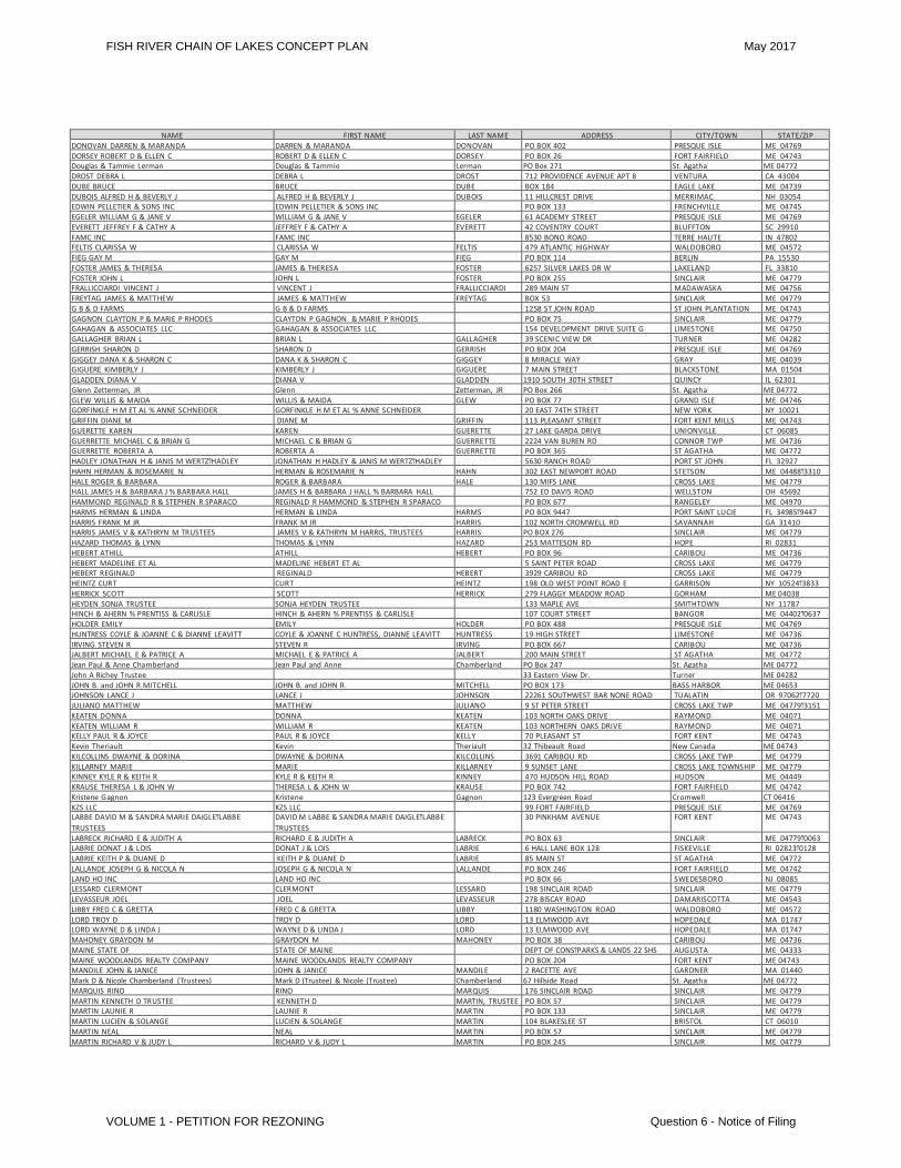
NAME FIRST NAME LAST NAME ADDRESS CITY/TOWN STATE/ZIP DONOVAN DARREN & MARANDA DARREN & MARANDA DONOVAN PO BOX 402 PRESQUE ISLE ME 04769 DORSEY ROBERT D & ELLEN C ROBERT D & ELLEN C DORSEY PO BOX 26 FORT FAIRFIELD ME 04743 Douglas & Tammie Lerman Douglas & Tammie Lerman PO Box 271 St. Agatha ME 04772 DROST DEBRA L DEBRA L DROST 712 PROVIDENCE AVENUE APT 8 VENTURA CA 43004 DUBE BRUCE BRUCE DUBE BOX 184 EAGLE LAKE ME 04739 DUBOIS ALFRED H & BEVERLY J ALFRED H & BEVERLY J DUBOIS 11 HILLCREST DRIVE MERRIMAC NH 03054 EDWIN PELLETIER & SONS INC EDWIN PELLETIER & SONS INC PO BOX 133 FRENCHVILLE ME 04745 EGELER WILLIAM G & JANE V WILLIAM G & JANE V EGELER 61 ACADEMY STREET PRESQUE ISLE ME 04769 EVERETT JEFFREY F & CATHY A JEFFREY F & CATHY A EVERETT 42 COVENTRY COURT BLUFFTON SC 29910 FAMC INC FAMC INC 8530 BONO ROAD TERRE HAUTE IN 47802 FELTIS CLARISSA W CLARISSA W FELTIS 479 ATLANTIC HIGHWAY WALDOBORO ME 04572 FIEG GAY M GAY M FIEG PO BOX 114 BERLIN PA 15530 FOSTER JAMES & THERESA JAMES & THERESA FOSTER 6257 SILVER LAKES DR W LAKELAND FL 33810 FOSTER JOHN L JOHN L FOSTER PO BOX 255 SINCLAIR ME 04779 FRALLICCIARDI VINCENT J VINCENT J FRALLICCIARDI 289 MAIN ST MADAWASKA ME 04756 FREYTAG JAMES & MATTHEW JAMES & MATTHEW FREYTAG BOX 53 SINCLAIR ME 04779 G B & D FARMS G B & D FARMS 1258 ST JOHN ROAD ST JOHN PLANTATION ME 04743 GAGNON CLAYTON P & MARIE P RHODES CLAYTON P GAGNON & MARIE P RHODES PO BOX 75 SINCLAIR ME 04779 GAHAGAN & ASSOCIATES LLC GAHAGAN & ASSOCIATES LLC 154 DEVELOPMENT DRIVE SUITE G LIMESTONE ME 04750 GALLAGHER BRIAN L BRIAN L GALLAGHER 39 SCENIC VIEW DR TURNER ME 04282 GERRISH SHARON D SHARON D GERRISH PO BOX 204 PRESQUE ISLE ME 04769 GIGGEY DANA K & SHARON C DANA K & SHARON C GIGGEY 8 MIRACLE WAY GRAY ME 04039 GIGUERE KIMBERLY J KIMBERLY J GIGUERE 7 MAIN STREET BLACKSTONE MA 01504 GLADDEN DIANA V DIANA V GLADDEN 1910 SOUTH 30TH STREET QUINCY IL 62301 Glenn Zetterman, JR Glenn Zetterman, JR PO Box 266 St. Agatha ME 04772 GLEW WILLIS & MAIDA WILLIS & MAIDA GLEW PO BOX 77 GRAND ISLE ME 04746 GORFINKLE H M ET AL % ANNE SCHNEIDER GORFINKLE H M ET AL % ANNE SCHNEIDER 20 EAST 74TH STREET NEW YORK NY 10021 GRIFFIN DIANE M DIANE M GRIFFIN 113 PLEASANT STREET FORT KENT MILLS ME 04743 GUERETTE KAREN KAREN GUERETTE 27 LAKE GARDA DRIVE UNIONVILLE CT 06085 GUERRETTE MICHAEL C & BRIAN G MICHAEL C & BRIAN G GUERRETTE 2224 VAN BUREN RD CONNOR TWP ME 04736 GUERRETTE ROBERTA A ROBERTA A GUERRETTE PO BOX 365 ST AGATHA ME 04772 HADLEY JONATHAN H & JANIS M WERTZͲHADLEY JONATHAN H HADLEY & JANIS M WERTZͲHADLEY 5630 RANCH ROAD PORT ST JOHN FL 32927 HAHN HERMAN & ROSEMARIE N HERMAN & ROSEMARIE N HAHN 302 EAST NEWPORT ROAD STETSON ME 04488Ͳ3310 HALE ROGER & BARBARA ROGER & BARBARA HALE 130 MIFS LANE CROSS LAKE ME 04779 HALL JAMES H & BARBARA J % BARBARA HALL JAMES H & BARBARA J HALL % BARBARA HALL 752 ED DAVIS ROAD WELLSTON OH 45692 HAMMOND REGINALD R & STEPHEN R SPARACO REGINALD R HAMMOND & STEPHEN R SPARACO PO BOX 677 RANGELEY ME 04970 HARMS HERMAN & LINDA HERMAN & LINDA HARMS PO BOX 9447 PORT SAINT LUCIE FL 34985Ͳ9447 HARRIS FRANK M JR FRANK M JR HARRIS 102 NORTH CROMWELL RD SAVANNAH GA 31410 HARRIS JAMES V & KATHRYN M TRUSTEES JAMES V & KATHRYN M HARRIS, TRUSTEES HARRIS PO BOX 276 SINCLAIR ME 04779 HAZARD THOMAS & LYNN THOMAS & LYNN HAZARD 253 MATTESON RD HOPE RI 02831 HEBERT ATHILL ATHILL HEBERT PO BOX 96 CARIBOU ME 04736 HEBERT MADELINE ET AL MADELINE HEBERT ET AL 5 SAINT PETER ROAD CROSS LAKE ME 04779 HEBERT REGINALD REGINALD HEBERT 3929 CARIBOU RD CROSS LAKE ME 04779 HEINTZ CURT CURT HEINTZ 198 OLD WEST POINT ROAD E GARRISON NY 10524Ͳ3833 HERRICK SCOTT SCOTT HERRICK 279 FLAGGY MEADOW ROAD GORHAM ME 04038 HEYDEN SONJA TRUSTEE SONJA HEYDEN TRUSTEE 133 MAPLE AVE SMITHTOWN NY 11787 HINCH & AHERN % PRENTISS & CARLISLE HINCH & AHERN % PRENTISS & CARLISLE 107 COURT STREET BANGOR ME 04402Ͳ0637 HOLDER EMILY EMILY HOLDER PO BOX 488 PRESQUE ISLE ME 04769 HUNTRESS COYLE & JOANNE C & DIANNE LEAVITT COYLE & JOANNE C HUNTRESS, DIANNE LEAVITT HUNTRESS 19 HIGH STREET LIMESTONE ME 04736 IRVING STEVEN R STEVEN R IRVING PO BOX 667 CARIBOU ME 04736 JALBERT MICHAEL E & PATRICE A MICHAEL E & PATRICE A JALBERT 200 MAIN STREET ST AGATHA ME 04772 Jean Paul & Anne Chamberland Jean Paul and Anne Chamberland PO Box 247 St. Agatha ME 04772 John A Richey Trustee 33 Eastern View Dr. Turner ME 04282 JOHN B. and JOHN R.MITCHELL JOHN B. and JOHN R. MITCHELL PO BOX 173 BASS HARBOR ME 04653 JOHNSON LANCE J LANCE J JOHNSON 22261 SOUTHWEST BAR NONE ROAD TUALATIN OR 97062Ͳ7720 JULIANO MATTHEW MATTHEW JULIANO 9 ST PETER STREET CROSS LAKE TWP ME 04779Ͳ3151 KEATEN DONNA DONNA KEATEN 103 NORTH OAKS DRIVE RAYMOND ME 04071 KEATEN WILLIAM R WILLIAM R KEATEN 103 NORTHERN OAKS DRIVE RAYMOND ME 04071 KELLY PAUL R & JOYCE PAUL R & JOYCE KELLY 70 PLEASANT ST FORT KENT ME 04743 Kevin Theriault Kevin Theriault 32 Thibeault Road New Canada ME 04743 KILCOLLINS DWAYNE & DORINA DWAYNE & DORINA KILCOLLINS 3691 CARIBOU RD CROSS LAKE TWP ME 04779 KILLARNEY MARIE MARIE KILLARNEY 9 SUNSET LANE CROSS LAKE TOWNSHIP ME 04779 KINNEY KYLE R & KEITH R KYLE R & KEITH R KINNEY 470 HUDSON HILL ROAD HUDSON ME 04449 KRAUSE THERESA L & JOHN W THERESA L & JOHN W KRAUSE PO BOX 742 FORT FAIRFIELD ME 04742 Kristene Gagnon Kristene Gagnon 123 Evergreen Road Cromwell CT 06416 KZS LLC KZS LLC 99 FORT FAIRFIELD PRESQUE ISLE ME 04769 LABBE DAVID M & SANDRA MARIE DAIGLEͲLABBE TRUSTEES
DAVID M LABBE & SANDRA MARIE DAIGLEͲLABBE TRUSTEES 30 PINKHAM AVENUE FORT KENT ME 04743
LABRECK RICHARD E & JUDITH A RICHARD E & JUDITH A LABRECK PO BOX 63 SINCLAIR ME 04779Ͳ0063 LABRIE DONAT J & LOIS DONAT J & LOIS LABRIE 6 HALL LANE BOX 128 FISKEVILLE RI 02823Ͳ0128 LABRIE KEITH P & DUANE D KEITH P & DUANE D LABRIE 85 MAIN ST ST AGATHA ME 04772 LALLANDE JOSEPH G & NICOLA N JOSEPH G & NICOLA N LALLANDE PO BOX 246 FORT FAIRFIELD ME 04742 LAND HO INC LAND HO INC PO BOX 66 SWEDESBORO NJ 08085 LESSARD CLERMONT CLERMONT LESSARD 198 SINCLAIR ROAD SINCLAIR ME 04779 LEVASSEUR JOEL JOEL LEVASSEUR 278 BISCAY ROAD DAMARISCOTTA ME 04543 LIBBY FRED C & GRETTA FRED C & GRETTA LIBBY 1180 WASHINGTON ROAD WALDOBORO ME 04572 LORD TROY D TROY D LORD 13 ELMWOOD AVE HOPEDALE MA 01747 LORD WAYNE D & LINDA J WAYNE D & LINDA J LORD 13 ELMWOOD AVE HOPEDALE MA 01747 MAHONEY GRAYDON M GRAYDON M MAHONEY PO BOX 38 CARIBOU ME 04736 MAINE STATE OF STATE OF MAINE DEPT OF CONSͲPARKS & LANDS 22 SHS AUGUSTA ME 04333 MAINE WOODLANDS REALTY COMPANY MAINE WOODLANDS REALTY COMPANY PO BOX 204 FORT KENT ME 04743 MANDILE JOHN & JANICE JOHN & JANICE MANDILE 2 RACETTE AVE GARDNER MA 01440 Mark D & Nicole Chamberland (Trustees) Mark D (Trustee) & Nicole (Trustee) Chamberland 67 Hillside Road St. Agatha ME 04772 MARQUIS RINO RINO MARQUIS 176 SINCLAIR ROAD SINCLAIR ME 04779 MARTIN KENNETH D TRUSTEE KENNETH D MARTIN, TRUSTEE PO BOX 57 SINCLAIR ME 04779 MARTIN LAUNIE R LAUNIE R MARTIN PO BOX 133 SINCLAIR ME 04779 MARTIN LUCIEN & SOLANGE LUCIEN & SOLANGE MARTIN 104 BLAKESLEE ST BRISTOL CT 06010 MARTIN NEAL NEAL MARTIN PO BOX 57 SINCLAIR ME 04779 MARTIN RICHARD V & JUDY L RICHARD V & JUDY L MARTIN PO BOX 245 SINCLAIR ME 04779
FISH RIVER CHAIN OF LAKES CONCEPT PLAN May 2017
VOLUME 1 - PETITION FOR REZONING Question 6 - Notice of Filing
NAME FIRST NAME LAST NAME ADDRESS CITY/TOWN STATE/ZIP MARTIN ROLAND D RICHARD V JAMES S & MARCIA A STURGEON
ROLAND D RICHARD V JAMES S MARTIN & MARCIA A STURGEON PO BOX 97 SINCLAIR ME 04779
MARTIN THERESA THERESA MARTIN PO BOX 97 SINCLAIR ME 04779Ͳ0097 MARTIN THOMAS & WILLIAM THOMAS & WILLIAM MARTIN 778 ROUTE 3 PALERMO ME 04354 MCGUIRE JAMES I & CHERYL A JAMES I & CHERYL A MCGUIRE 1106 KENNEBEC RD HAMPDEN ME 04444 MCLAUGHLIN VAUGHN J GEORGE F & MARTHA J HADLEY VAUGHN J & GEORGE F MCLAUGHLIN, MARTHA J
HADLEY MCLAUGHLIN 179 CENTER LIMESTONE RD FORT FAIRFIELD ME 04742
MCQUADE JAMES H & R & TERRY D JAMES H & R & TERRY D MCQUADE 150 MAIN ST CARIBOU ME 04736 MELINDA & ZACKARY ZETTERMAN MELINDA & ZACKARY ZETTERMAN PO BOX 266 ST. AGATHA ME 04772 MENDELSON LLOYD M LLOYD M MENDELSON PO BOX 441 NEW HARBOR ME 04554 MICHAUD ELAINE M TRUSTEE ELAINE M MICHAUD REV TRUST
ELAINE M MICHAUD, TRUSTEE ELAINE M MICHAUD, REV TRUST 293 OAK STREET MANCHESTER NH 03104
MITCHELL J BRETT & REGINA M BRETT J & REGINA M MITCHELL PO BOX 173 BASS HARBOR ME 04653 MONTAGNA HENRIETTA C HENRIETTA C MONTAGNA 2757 CARIBOU ROAD CROSS LAKE ME 04779 MONTAGNA RAYMOND RAYMOND MONTAGNA 49 MCCULLOCH DRIVE SOMERS CT 06071 MORENCY RENE LOUIS & MARIE HELENE RENE LOUIS MORENCY & MARIE HELENE 4155 DEEP LAKE BOUNDARY ROAD PMB COLVILLE WA 99114 MORIN RICHARD RICHARD MORIN 221 NORWAY DRIVE WILKSBORO NC 28697Ͳ7373 MUD LAKE LLC % JENNIFER STEVENSͲCURWOOD MUD LAKE LLC % JENNIFER STEVENSͲCURWOOD 102 MITCHELL ROAD NOTTINGHAM NH 03290 MURPHY KEVIN & BETH KEVIN & BETH MURPHY 17 HODGKINS LANE LAMOINE ME 04605 N AROOSTOOK REGIONAL SEPTAGE BOARD N AROOSTOOK REGIONAL SEPTAGE BOARD PO BOX 110 ST AGATHA ME 04772 NADEAU JAMES L JAMES L NADEAU 26 EAST MAIN ST FORT KENT ME 04743 NBB, INC. 907 MAIN STREET ST. AGATHA ME 04772 NECEVSKI ZLATKO ZLATKO NECEVSKI 90 HERITAGE ROAD OAKLAND ME 04963 NIEBEL CHRISTOPHER S & DEBRA G CHRISTOPHER S & DEBRA G NIEBEL 9 NW 25TH STREET DELRAY BEACH FL 33444 NORDIC PROPERTIES LLC NORDIC PROPERTIES LLC 460 YORK STREET CARIBOU ME 04735Ͳ2051 NORSWORTHY DARREL R & JUDITH S DARREL R & JUDITH S NORSWORTHY 104 MIFFS LANE CROSS LAKE ME 04779 NORWOOD DWAYNE L & CHRIS & LISA PARSONS DWAYNE L NORWOOD & CHRIS & LISA PARSONS 22 SMITH BROOK ROAD WALTHAM ME 04605 OLMSTEAD GARY GARY OLMSTEAD 14 DRIFTWOOD RD TERRYVILLE CT 06786 OLMSTEAD NORMAN JACQUELINE GARY & CHRISTIANA NORMAN JACQUELINE GARY & CHRISTIANA OLMSTEAD PO BOX 203 SINCLAIR ME 04779 OUELLETTE CECILE & JEANETTE CECILE & JEANETTE OUELLETTE PO BOX 35 SINCLAIR ME 04779Ͳ0035 OUELLETTE EMILE R & JOAN A EMILE R & JOAN A OUELLETTE PO BOX 42 SINCLAIR ME 04779 OUELLETTE HUBERT & JANET HUBERT & JANET OUELLETTE 594 MAIN ST CARIBOU ME 04736Ͳ4419 OUELLETTE JAMES & MARY LOU JAMES & MARY LOU OUELLETTE 3723 CARIBOU RD CROSS LAKE ME 04779 OUELLETTE JAMES R & SHARON L TRUSTEES JAMES R & SHARON L OUELLETTE TRUSTEES 118 AROOSTOOK FALLS RD FORT FAIRFIELD ME 04742 OUELLETTE JAMES RALPH JR MICHAEL & TAMMY DUBE JAMES RALPH OUELLETTE JR & MICHAEL & TAMMY
DUBE 3723 CARIBOU ROAD CROSS LAKE ME 04779
OUELLETTE TAMMY TAMMY OUELLETTE 5 BIRCH STREET FORT KENT ME 04736 OWENS TIMOTHY TIMOTHY OWENS 618 GURNET RD BRUNSWICK ME 04011Ͳ3701 PAGE NORMAN NORMAN PAGE 556 BOG ROAD LIMESTONE ME 04750 PALM ROBERT M II & PAMELA J ROBERT M II & PAMELA J PALM 68 HILLSIDE ST PRESQUE ISLE ME 04769 PALMER JOEL O & LINDA M JOEL O & LINDA M PALMER 14 SHAWN LANE LIMERICK ME 04048Ͳ4051 PALUZZI CARLO & BLANCA C CARLO & BLANCA C PALUZZI 590 SMITHTOWN AVE BOHEMIA NY 11716 PANELLA THOMAS J & FAITH E THOMAS J & FAITH E PANELLA PO BOX 182 SINCLAIR ME 04779Ͳ0182 PARADIS PAUL & EDITH PAUL & EDITH PARADIS 325 GLENN STREET NEW BRITAIN CT 06051 PARISI JACK & BETTY JACK & BETTY PARISI 43 HARVEST RD CARIBOU ME 04736 Patricia Macneil, Victor Serafin 21 Washington Terr Newtonville MA 02460 Paul A & Michael P Cyr Paul A & Michael P Cyr 165 Gagnon Road Madawaska ME 04756 Paul Martin Paul Martin PO Box 492 Moody ME 04054 PELLETIER APRIL & CEDRIC T APRIL & CEDRIC T PELLETIER 257 THOROUGH FARE RD SINCLAIR ME 04779 PELLETIER CLIFFORD J & NANCY A CLIFFORD J & NANCY A PELLETIER 19 GAGNON ROAD CROSS LAKE ME 04779 PELLETIER ERNEST J III ERNEST J PELLETIER III 7011 W PARMER LANE #131 AUTSIN TX 78729 PELLETIER GARY L & LINDA L GARY L & LINDA L PELLETIER 2873 CARIBOU ROAD SINCLAIR ME 04779 PELLETIER JOHN T & PAULINE A JOHN T & PAULINE A PELLETIER 1982 MOUNT VERNON ROAD SOUTHINGTON CT 06489 PELLETIER OSCAR E & GLORIA M OSCAR E & GLORIA M PELLETIER 6 DEWBERRY DRIVE APT. 118 PRESQUE ISLE ME 04769 PELUSO SHAWN P SHAWN P PELUSO 265 COSTELLO RD GARDINER ME 04345Ͳ6444 PENNINGER JARVIS K & ERIKA JARVIS K & ERIKA PENNINGER 5620 GEORGIA O'KEEFFE ROAD LAS CRUCES NM 88011 PETERSON JEFFREY G ET AL JEFFREY G PETERSON ET AL 236 CENTER ST BREWER ME 04412 Phillip and Hermence Michaud Phillip and Hermence Michaud 441 Main Street, PO Box 159 St. Agatha ME 04772 PICARD ANDRE ANDRE PICARD PO BOX 58 SINCLAIR TWP ME 04779 PICARD GINETTE GINETTE PICARD 3049 HICKORYMEDE COURT ELLICOTT CITY MD 21042 PICARD MARIE JEANNE MARIE JEANNE PICARD PO BOX 58 SINCLAIR ME 04779 PICARDͲGAFFNEY GINETTE GINETTE PICARDͲGAFFNEY 3049 HICKORYMEDE CT ELLICOTT CITY MD 21042 PIERSON HUGH C & CAROL A FAMILY TRUST HUGH C & CAROL A PIERSON FAMILY TRUST 745 MAIN ST CARIBOU ME 04736 POMERANTZ JOSEPH T & DONNA JOSEPH T & DONNA POMERANTZ 405 QUEEN ANNE CLUB DR STEVENSVILLE MD 21666 PRATICO TINA & TROY GUERRETTE TINA & TROY GUERRETTE PRATICO 11 DEERFIELD WAY FALMOUTH ME 04105Ͳ2625 PRESS LAURA M LAURA M PRESS 512 SWEET PEACH LANE FORT MILL SC 29715 RARES SUZANNE C TRUSTEE SUZANNE RARES REVOCABLE TRUST
SUZANNE C RARES TRUSTEE, SUZANNE RARES REVOCABLE TRUST 4300 SW 73RD AVENUE SUITE 103 MIAMI FL 33155
RAYMOND DAVID TRUSTEE PELLETIER FAMILY TRUST DAVID RAYMOND TRUSTEE, PELLETIER FAMILY TRUST 429 MAIN STREET PRESQUE ISLE ME 04769
RICHARD GAIL A & RANDALL A GAIL A & RANDALL A RICHARD 41 HIGH STREET LIVERMORE FALLS ME 04254 RODGERS GARY A & LINDA A GARY A & LINDA A RODGERS PO BOX 84 SINCLAIR ME 04779Ͳ0084 ROHE TRUST ROHE TRUST 43 DUDLEY ST PRESQUE ISLE ME 04769 ROMAN CATHOLIC DIOCESE OF MAINE ROMAN CATHOLIC DIOCESE OF MAINE CHANCERY OFFICE 510 OCEAN AVE PORTLAND ME 04101 ROMANN BRIAN K & JANICE M BRIAN K & JANICE M ROMANN 866 CHARETTE HILL RD FORT KENT ME 04743 ROSSIGNOL EMILIO & CHARLEEN M EMILIO & CHARLEEN M ROSSIGNOL 172 WILDERNESS DR MEDWAY ME 04460 ROSSIGNOL RICHARD & LUCILLE RICHARD & LUCILLE ROSSIGNOL 4072 CARIBOU RD SINCLAIR ME 04779 ROY JACQUELINE JACQUELINE ROY 304 SINCLAIR ROAD SINCLAIR ME 04779 ROY LUCY ANN BELL L/T LUCY ANN BELL L/T ROY PO BOX 83 SINCLAIR ME 04779 ROY PETER S SHERRY L & LUCYͲANN PETER S, SHERRY L & LUCYͲANN ROY 1819 WORTON BLVD WEST MIFFLIN PA 15122Ͳ3615 ROY RICHARD R RICHARD R ROY PO BOX 536 MADAWASKA ME 04756 ROY SERGE & LAURA SERGE & LAURA ROY 129 JAMES DRIVE BROADALBIN NY 12025 SCHOEL MAVIS W MAVIS W SCHOEL PO BOX 39 CARIBOU ME 04736 SEARLES WENDALL & LILY & MICHAEL L WENDALL & LILY & MICHAEL L SEARLES 3 SEARLES DRIVE CARIBOU ME 04736 SEAVEY KATHLEEN M KATHLEEN M SEAVEY 13 STONEY BROOK RD TRENTON ME 04605 SEVIGNY GERARD O GERARD O SEVIGNY PO BOX 519 WAKEFIELD MA 01880Ͳ4419 SHADY JOAN JOAN SHADY 20 NAMSKAKET RD ORLEANS MA 02653 SHEA MICHAEL J MICHAEL J SHEA 44 DEER RUN DURHAM ME 04222 SIMON PEDRO T MD PEDRO T SIMON MD 5 REDPOLL DR TOPSHAM ME 04086 SINCLAIR EDMUND EDMUND SINCLAIR BOX 16 SINCLAIR ME 04779
FISH RIVER CHAIN OF LAKES CONCEPT PLAN May 2017
VOLUME 1 - PETITION FOR REZONING Question 6 - Notice of Filing
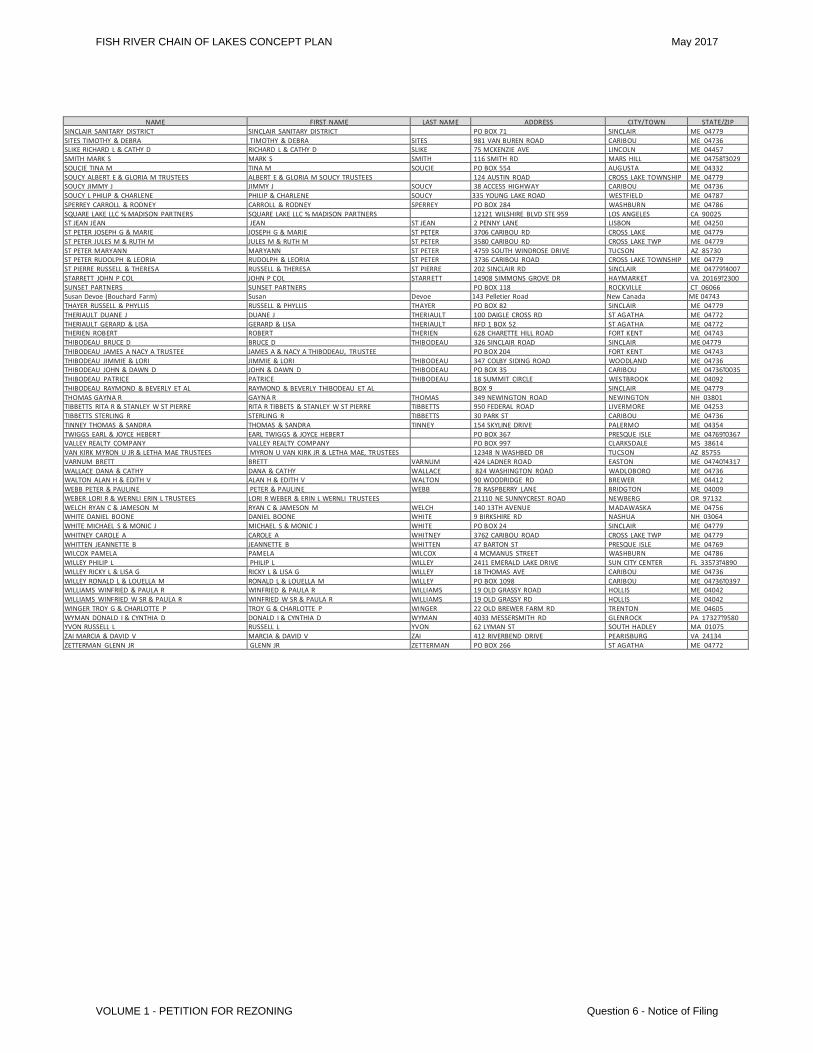
NAME FIRST NAME LAST NAME ADDRESS CITY/TOWN STATE/ZIP SINCLAIR SANITARY DISTRICT SINCLAIR SANITARY DISTRICT PO BOX 71 SINCLAIR ME 04779 SITES TIMOTHY & DEBRA TIMOTHY & DEBRA SITES 981 VAN BUREN ROAD CARIBOU ME 04736 SLIKE RICHARD L & CATHY D RICHARD L & CATHY D SLIKE 75 MCKENZIE AVE LINCOLN ME 04457 SMITH MARK S MARK S SMITH 116 SMITH RD MARS HILL ME 04758Ͳ3029 SOUCIE TINA M TINA M SOUCIE PO BOX 554 AUGUSTA ME 04332 SOUCY ALBERT E & GLORIA M TRUSTEES ALBERT E & GLORIA M SOUCY TRUSTEES 124 AUSTIN ROAD CROSS LAKE TOWNSHIP ME 04779 SOUCY JIMMY J JIMMY J SOUCY 38 ACCESS HIGHWAY CARIBOU ME 04736 SOUCY L PHILIP & CHARLENE PHILIP & CHARLENE SOUCY 335 YOUNG LAKE ROAD WESTFIELD ME 04787 SPERREY CARROLL & RODNEY CARROLL & RODNEY SPERREY PO BOX 284 WASHBURN ME 04786 SQUARE LAKE LLC % MADISON PARTNERS SQUARE LAKE LLC % MADISON PARTNERS 12121 WILSHIRE BLVD STE 959 LOS ANGELES CA 90025 ST JEAN JEAN JEAN ST JEAN 2 PENNY LANE LISBON ME 04250 ST PETER JOSEPH G & MARIE JOSEPH G & MARIE ST PETER 3706 CARIBOU RD CROSS LAKE ME 04779 ST PETER JULES M & RUTH M JULES M & RUTH M ST PETER 3580 CARIBOU RD CROSS LAKE TWP ME 04779 ST PETER MARYANN MARYANN ST PETER 4759 SOUTH WINDROSE DRIVE TUCSON AZ 85730 ST PETER RUDOLPH & LEORIA RUDOLPH & LEORIA ST PETER 3736 CARIBOU ROAD CROSS LAKE TOWNSHIP ME 04779 ST PIERRE RUSSELL & THERESA RUSSELL & THERESA ST PIERRE 202 SINCLAIR RD SINCLAIR ME 04779Ͳ4007 STARRETT JOHN P COL JOHN P COL STARRETT 14908 SIMMONS GROVE DR HAYMARKET VA 20169Ͳ2300 SUNSET PARTNERS SUNSET PARTNERS PO BOX 118 ROCKVILLE CT 06066 Susan Devoe (Bouchard Farm) Susan Devoe 143 Pelletier Road New Canada ME 04743 THAYER RUSSELL & PHYLLIS RUSSELL & PHYLLIS THAYER PO BOX 82 SINCLAIR ME 04779 THERIAULT DUANE J DUANE J THERIAULT 100 DAIGLE CROSS RD ST AGATHA ME 04772 THERIAULT GERARD & LISA GERARD & LISA THERIAULT RFD 1 BOX 52 ST AGATHA ME 04772 THERIEN ROBERT ROBERT THERIEN 628 CHARETTE HILL ROAD FORT KENT ME 04743 THIBODEAU BRUCE D BRUCE D THIBODEAU 326 SINCLAIR ROAD SINCLAIR ME 04779 THIBODEAU JAMES A NACY A TRUSTEE JAMES A & NACY A THIBODEAU, TRUSTEE PO BOX 204 FORT KENT ME 04743 THIBODEAU JIMMIE & LORI JIMMIE & LORI THIBODEAU 347 COLBY SIDING ROAD WOODLAND ME 04736 THIBODEAU JOHN & DAWN D JOHN & DAWN D THIBODEAU PO BOX 35 CARIBOU ME 04736Ͳ0035 THIBODEAU PATRICE PATRICE THIBODEAU 18 SUMMIT CIRCLE WESTBROOK ME 04092 THIBODEAU RAYMOND & BEVERLY ET AL RAYMOND & BEVERLY THIBODEAU ET AL BOX 9 SINCLAIR ME 04779 THOMAS GAYNA R GAYNA R THOMAS 349 NEWINGTON ROAD NEWINGTON NH 03801 TIBBETTS RITA R & STANLEY W ST PIERRE RITA R TIBBETS & STANLEY W ST PIERRE TIBBETTS 950 FEDERAL ROAD LIVERMORE ME 04253 TIBBETTS STERLING R STERLING R TIBBETTS 30 PARK ST CARIBOU ME 04736 TINNEY THOMAS & SANDRA THOMAS & SANDRA TINNEY 154 SKYLINE DRIVE PALERMO ME 04354 TWIGGS EARL & JOYCE HEBERT EARL TWIGGS & JOYCE HEBERT PO BOX 367 PRESQUE ISLE ME 04769Ͳ0367 VALLEY REALTY COMPANY VALLEY REALTY COMPANY PO BOX 997 CLARKSDALE MS 38614 VAN KIRK MYRON U JR & LETHA MAE TRUSTEES MYRON U VAN KIRK JR & LETHA MAE, TRUSTEES 12348 N WASHBED DR TUCSON AZ 85755 VARNUM BRETT BRETT VARNUM 424 LADNER ROAD EASTON ME 04740Ͳ4317 WALLACE DANA & CATHY DANA & CATHY WALLACE 824 WASHINGTON ROAD WADLOBORO ME 04736 WALTON ALAN H & EDITH V ALAN H & EDITH V WALTON 90 WOODRIDGE RD BREWER ME 04412 WEBB PETER & PAULINE PETER & PAULINE WEBB 78 RASPBERRY LANE BRIDGTON ME 04009 WEBER LORI R & WERNLI ERIN L TRUSTEES LORI R WEBER & ERIN L WERNLI TRUSTEES 21110 NE SUNNYCREST ROAD NEWBERG OR 97132 WELCH RYAN C & JAMESON M RYAN C & JAMESON M WELCH 140 13TH AVENUE MADAWASKA ME 04756 WHITE DANIEL BOONE DANIEL BOONE WHITE 9 BIRKSHIRE RD NASHUA NH 03064 WHITE MICHAEL S & MONIC J MICHAEL S & MONIC J WHITE PO BOX 24 SINCLAIR ME 04779 WHITNEY CAROLE A CAROLE A WHITNEY 3762 CARIBOU ROAD CROSS LAKE TWP ME 04779 WHITTEN JEANNETTE B JEANNETTE B WHITTEN 47 BARTON ST PRESQUE ISLE ME 04769 WILCOX PAMELA PAMELA WILCOX 4 MCMANUS STREET WASHBURN ME 04786 WILLEY PHILIP L PHILIP L WILLEY 2411 EMERALD LAKE DRIVE SUN CITY CENTER FL 33573Ͳ4890 WILLEY RICKY L & LISA G RICKY L & LISA G WILLEY 18 THOMAS AVE CARIBOU ME 04736 WILLEY RONALD L & LOUELLA M RONALD L & LOUELLA M WILLEY PO BOX 1098 CARIBOU ME 04736Ͳ0397 WILLIAMS WINFRIED & PAULA R WINFRIED & PAULA R WILLIAMS 19 OLD GRASSY ROAD HOLLIS ME 04042 WILLIAMS WINFRIED W SR & PAULA R WINFRIED W SR & PAULA R WILLIAMS 19 OLD GRASSY RD HOLLIS ME 04042 WINGER TROY G & CHARLOTTE P TROY G & CHARLOTTE P WINGER 22 OLD BREWER FARM RD TRENTON ME 04605 WYMAN DONALD I & CYNTHIA D DONALD I & CYNTHIA D WYMAN 4033 MESSERSMITH RD GLENROCK PA 17327Ͳ9580 YVON RUSSELL L RUSSELL L YVON 62 LYMAN ST SOUTH HADLEY MA 01075 ZAI MARCIA & DAVID V MARCIA & DAVID V ZAI 412 RIVERBEND DRIVE PEARISBURG VA 24134 ZETTERMAN GLENN JR GLENN JR ZETTERMAN PO BOX 266 ST AGATHA ME 04772
FISH RIVER CHAIN OF LAKES CONCEPT PLAN May 2017
VOLUME 1 - PETITION FOR REZONING Question 6 - Notice of Filing
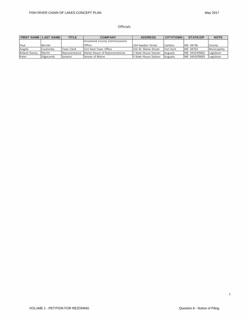
Officials
FIRST NAME LAST NAME TITLE COMPANY ADDRESS CITY/TOWN STATE/ZIP NOTE Paul
Bernier
Aroostook County Commissioners Office
144 Sweden Street
Caribou
ME 04736
County
Angela Coulombe Town Clerk Fort Kent Town Office 416 W. Maine Street Fort Kent ME 04743 Municipality Roland Danny Martin Representative Maine House of Representatives 2 State House Station Augusta ME 04333Ͳ0002 Legislator Peter Edgecomb Senator Senate of Maine 3 State House Station Augusta ME 04333Ͳ0003 Legislator
1
FISH RIVER CHAIN OF LAKES CONCEPT PLAN May 2017
VOLUME 1 - PETITION FOR REZONING Question 6 - Notice of Filing
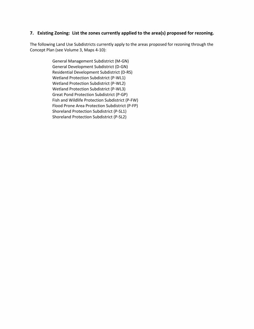
7. Existing Zoning: List the zones currently applied to the area(s) proposed for rezoning.
The following Land Use Subdistricts currently apply to the areas proposed for rezoning through the Concept Plan (see Volume 3, Maps 4-10):
General Management Subdistrict (M-GN) General Development Subdistrict (D-GN) Residential Development Subdistrict (D-RS) Wetland Protection Subdistrict (P-WL1) Wetland Protection Subdistrict (P-WL2) Wetland Protection Subdistrict (P-WL3) Great Pond Protection Subdistrict (P-GP) Fish and Wildlife Protection Subdistrict (P-FW) Flood Prone Area Protection Subdistrict (P-FP) Shoreland Protection Subdistrict (P-SL1) Shoreland Protection Subdistrict (P-SL2)
8. Current Use: Describe the current and historical use of the land proposed for rezoning
Residential development, recreational activities, and forestry have coexisted within the Plan area for decades. The Plan area includes approximately 425 leased or licensed camp lots, as well as forest management roads, large blocks of working forest, and significant areas of wildlife habitat (e.g. the Cross Lake Fen). Current and historic uses in the Plan area are described below, as well as in the Existing Conditions Report included as Appendix A.
Forestry. For generations, the lands in the region were held and managed by large paper companies, such as International Paper, Great Northern Paper, Bowater, and others. Today, the Plan area is owned by Petitioners Aroostook Timberlands LP, Allagash Timberlands LLC, and Maine Woodlands Realty Company and managed by Irving Woodlands (Irving). As discussed in detail in response to Question 20, the majority of the Plan area is actively managed forest land using sustainable forestry practices in accordance with an Outcome Based Forestry agreement with the State of Maine, a copy of which is included at Appendix C of Volume 2. Irving forestry operations in Maine help sustain over 1,800 jobs (direct, contractor, and indirect) in the region, supported by a full-time staff of over 30 professionals on the ground every day. Forest products from the operations help supply timber to 20 separate facilities in Maine, including the new state-of-the-art sawmill in Nashville Plantation. Irving ensures the sustainability of the forest and its economic benefits through an ongoing commitment to stewardship, research, and development, and Irving’s continued reforestation efforts, have led to over 56 million seedlings being planted in the past 35 years. Residential Use. Much of the residential development in the region occurs near lakes. Portions of the Plan area on Long, Cross, and Square Lakes are developed with both seasonal and year-round structures. When the Petitioners acquired the lands that make up the Plan area, there were over 400 camp lots already developed on these three lakes. These lots were created prior to the formation of the Land Use Regulation Commission (LURC) and are currently being leased or licensed to camp owners.
Irving leases or licenses 150 waterfront camp lots on both sides of Van Buren Cove on Long Lake. There are no camp lots on Mud Lake leased or licensed by Irving. Irving leases or licenses 237 camp lots on or near Cross Lake and 19 camp lots on the Mud / Cross Lake thoroughfare. On Square Lake, Irving leases or licenses 19 camp lots on the west side of the lake. For more information on existing residential development within the Plan area, see Sections 4 and 12 of the Existing Conditions Report, included as Appendix A, and Maps 14-17 in Volume 3 for the location and additional information on the camp lots.
Development within the Plan Area has historically shown a random growth pattern focused on the shorelines of the lakes. Maps 11 through 13 in Volume 3 are historic U.S. Geological Survey topographic maps of portions of the Plan Area that evidence historic growth patterns since 1931. Recreational Use. The Plan area is used for many traditional recreational activities (including hunting, fishing, boating, and camping). The Fish River Chain of Lakes is well-known for some of the best salmon and trout fishing in Maine. Each of the lakes is connected by a river-like thoroughfare, a natural channel that offers the unique opportunity to canoe from Long Lake through Mud Lake, Cross Lake, Square Lake, and Eagle Lake to the Fish River and back, nearly to the point of beginning. Irving allows public access at Van Buren Cove and at multiple campsites and picnic areas throughout the Plan area. Hunting for deer, bear, and other species occurs seasonally throughout the Plan area. With a yearly snowfall average of 115 inches, the Plan area is very popular with snowmobile enthusiasts. ATV riding is also very popular
FISH RIVER CHAIN OFLAKES CONCEPT PLAN May 2017
2
VOLUME 1 – PETITION FOR REZONING Question 8 – Current Use
within the Plan area. There are numerous marked trails maintained by local clubs. See Map 32 in Volume 3 for the approximate location of current trails.
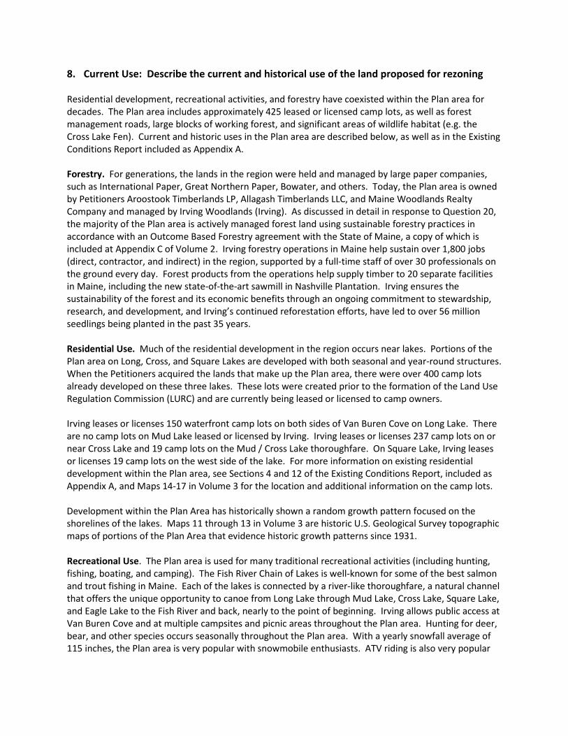
The Yerxas Camps. The Yerxas Camps (also known historically as the Gorfinkle Camps and the Square Lake Camps) is located on the east side of Square Lake and was a commercial sporting facility founded and constructed c. 1912 by Jack and Jennie Yerxa. The Yerxas Camps consisted of seven cabins of various sizes, plus storage buildings, a generator building, and privies. According to Maine Lodges and Sporting Camps (Wilson, Donald A., 2005), the Yerxas Camps were “a favorite gathering place for outdoor writers groups, and they were popular with Maine dignitaries, including Governor Lucius Barrow who was a regular.” The Yerxas Camps were discontinued as a sporting camp sometime prior to 1984. In December of 1984, LURC issued Development Permit DP 3655 to Daniel Hede authorizing him to operate the existing cabins and accessory structures as a commercial sporting camp facility, and to install a replacement combined sewage disposal system. Although the replacement system was installed, it is unclear whether the facility was ever operational; it has not been run as a commercial sporting camp facility for many years. Maine Woodlands Realty purchased the property in 2013 and it is now managed by Irving.
One of the remaining cabins at the Yerxas Camps
One of the remaining cabins at the Yerxas Camps
9A. Surrounding Uses and Resources / Existing Development: Describe the uses and resources of the area/region surrounding the land proposed for rezoning (i.e., commercial forest, farm land, seasonal/year-round residential use, commercial uses, etc.).
The Plan area is located in northern Aroostook County within the St. John River Valley region. The St. John Valley in Maine stretches from Allagash to Hamlin and encompasses parts of the Fish River waterway, including Long Lake, Mud Lake, Cross Lake, and Square Lake. The region has a long history of agricultural, industrial, and working forest uses. There are vast forest lands around portions of the Plan area, open agricultural fields around Long Lake and to the north toward Canada, and multiple saw mills, paper mills and other industrial activities related to the forest products and agriculture industries predominantly located in the larger surrounding communities of Madawaska, Fort Kent and Van Buren. The region is home to many small villages and hamlets, including New Sweden, Sinclair, St. Agatha, Stockholm, and Frenchville. Residents and visitors obtain most goods and services in the larger communities of Van Buren (approximately 11 miles east of Van Buren Cove), Fort Kent (approximately 16 miles northwest of Cross Lake), and Caribou (approximately 28 miles southeast of Cross Lake). These service center communities provide a full range of services, including health care institutions such as Northern Maine Medical Center in Fort Kent, education from K-12 to higher education at the University of Maine at Fort Kent, multiple lodging facilities, grocery stores, car dealerships, banks, restaurants, and numerous other small businesses. The overall economy in Aroostook County is less robust than in other parts of Maine, which is reflected in higher than average unemployment rates. According to the Maine Department of Labor’s Center for Workforce Research and Information (http://www.maine.gov/labor/cwri/laus.html ), the unemployment rate for Aroostook County in November, 2016, was 5.7% (not seasonally adjusted), up slightly from the year before. This is about 2.7% higher than the state average. Health care, forestry/forest products, and agriculture (including farms, processing facilities, and distribution) provide a large majority of the employment opportunities throughout Aroostook County. The forestry and the forest products industry has created and is responsible for over 4,600 jobs within Aroostook County, according to a 2016 report, Maine’s Forest Economy, by the Maine Forest Products Council. Recreational tourism also contributes to the regional economy. Common recreational uses in the region include camping, ATV riding, snowmobiling, fishing, hunting, cross-country skiing, boating, canoeing, and kayaking. The most significant recreational resource in the immediate vicinity is the 24,083-acre Eagle Lake Unit of the Maine Bureau of Parks and Lands, adjacent to the west side of the Plan area. Eagle Lake is a popular destination for four-season recreation and most of the land surrounding the 5,581-acre Eagle Lake is managed forestland. The western end of Eagle Lake, in and around the Town of Eagle Lake, includes several hundred camps and year-round residences. Within the State land, abutting the western end of the Project area, the shoreline is essentially undeveloped, with the exception of 5 camp lots and a commercial sporting camp on the Square Lake thoroughfare. Recreational use of Eagle Lake is also divided, with pleasure boaters and water-skiers concentrated west of the Eagle Lake Unit near the Town of Eagle Lake, and anglers and campers more common within the State land. In addition, the Plan area benefits from the recreational programming provided by the Maine Outdoor Sports Institute (formerly the Maine Winter Sports Center) headquartered in Caribou, as well as programs such as the North American and United States Biathlon Championships and other activities at the Fort Kent Outdoor Center.
FISH RIVER CHAIN OF LAKES CONCEPT PLAN May 2017
2
Question 9 – Surrounding Uses & Resources VOLUME 1 – PETITION FOR REZONING
For more information on the surrounding uses and resources, see the Existing Conditions Report included as Appendix A. 9B. Existing Development in the area/region: Describe existing development in the
area/region and within the area proposed for rezoning, including type, amount, density, and proximity (by road) to the area proposed for rezoning. If the plan includes only a portion of a lake, describe existing development on the rest of the lake in sufficient detail to understand the context of the proposed plan.
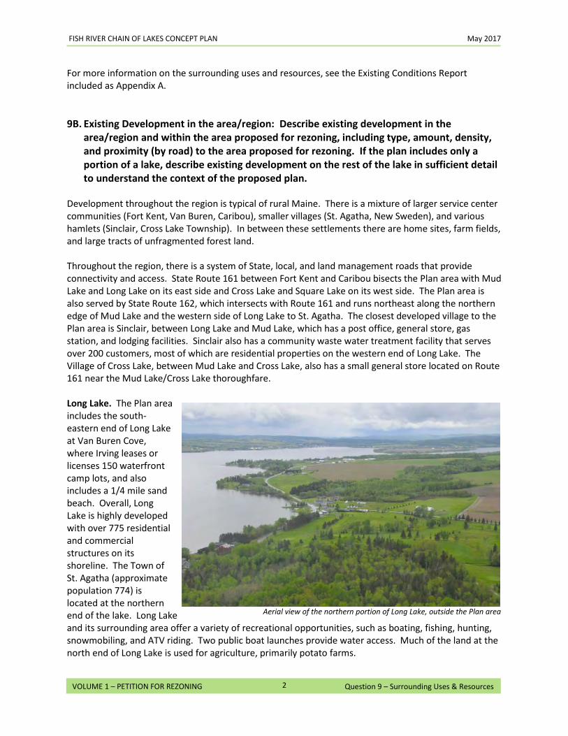
Development throughout the region is typical of rural Maine. There is a mixture of larger service center communities (Fort Kent, Van Buren, Caribou), smaller villages (St. Agatha, New Sweden), and various hamlets (Sinclair, Cross Lake Township). In between these settlements there are home sites, farm fields, and large tracts of unfragmented forest land. Throughout the region, there is a system of State, local, and land management roads that provide connectivity and access. State Route 161 between Fort Kent and Caribou bisects the Plan area with Mud Lake and Long Lake on its east side and Cross Lake and Square Lake on its west side. The Plan area is also served by State Route 162, which intersects with Route 161 and runs northeast along the northern edge of Mud Lake and the western side of Long Lake to St. Agatha. The closest developed village to the Plan area is Sinclair, between Long Lake and Mud Lake, which has a post office, general store, gas station, and lodging facilities. Sinclair also has a community waste water treatment facility that serves over 200 customers, most of which are residential properties on the western end of Long Lake. The Village of Cross Lake, between Mud Lake and Cross Lake, also has a small general store located on Route 161 near the Mud Lake/Cross Lake thoroughfare. Long Lake. The Plan area includes the south-eastern end of Long Lake at Van Buren Cove, where Irving leases or licenses 150 waterfront camp lots, and also includes a 1/4 mile sand beach. Overall, Long Lake is highly developed with over 775 residential and commercial structures on its shoreline. The Town of St. Agatha (approximate population 774) is located at the northern end of the lake. Long Lake and its surrounding area offer a variety of recreational opportunities, such as boating, fishing, hunting, snowmobiling, and ATV riding. Two public boat launches provide water access. Much of the land at the north end of Long Lake is used for agriculture, primarily potato farms.
Aerial view of the northern portion of Long Lake, outside the Plan area
FISH RIVER CHAIN OF LAKES CONCEPT PLAN May 2017
3
Question 9 – Surrounding Uses & Resources VOLUME 1 – PETITION FOR REZONING
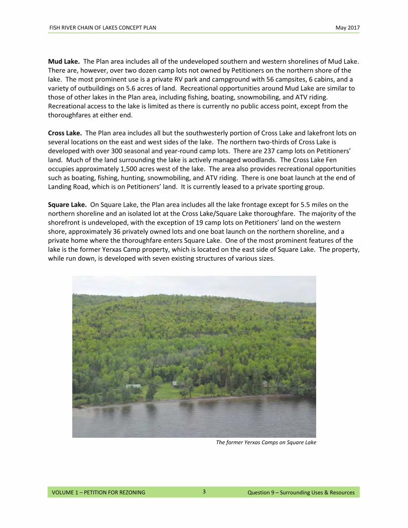
Mud Lake. The Plan area includes all of the undeveloped southern and western shorelines of Mud Lake. There are, however, over two dozen camp lots not owned by Petitioners on the northern shore of the lake. The most prominent use is a private RV park and campground with 56 campsites, 6 cabins, and a variety of outbuildings on 5.6 acres of land. Recreational opportunities around Mud Lake are similar to those of other lakes in the Plan area, including fishing, boating, snowmobiling, and ATV riding. Recreational access to the lake is limited as there is currently no public access point, except from the thoroughfares at either end. Cross Lake. The Plan area includes all but the southwesterly portion of Cross Lake and lakefront lots on several locations on the east and west sides of the lake. The northern two-thirds of Cross Lake is developed with over 300 seasonal and year-round camp lots. There are 237 camp lots on Petitioners’ land. Much of the land surrounding the lake is actively managed woodlands. The Cross Lake Fen occupies approximately 1,500 acres west of the lake. The area also provides recreational opportunities such as boating, fishing, hunting, snowmobiling, and ATV riding. There is one boat launch at the end of Landing Road, which is on Petitioners’ land. It is currently leased to a private sporting group. Square Lake. On Square Lake, the Plan area includes all the lake frontage except for 5.5 miles on the northern shoreline and an isolated lot at the Cross Lake/Square Lake thoroughfare. The majority of the shorefront is undeveloped, with the exception of 19 camp lots on Petitioners’ land on the western shore, approximately 36 privately owned lots and one boat launch on the northern shoreline, and a private home where the thoroughfare enters Square Lake. One of the most prominent features of the lake is the former Yerxas Camp property, which is located on the east side of Square Lake. The property, while run down, is developed with seven existing structures of various sizes.
The former Yerxas Camps on Square Lake
10. Proposed Uses: Describe all proposed uses of the land involved in this rezoning petition. If any subdivisions are proposed, describe the types of subdivisions (seasonal, year-round, residential, commercial, etc.) and the numbers and sizes of lots within each subdivision (including any common areas or lots designated to remain undeveloped). Attach a site plan that shows all locations of the proposed subdivisions within the concept plan. If structural development is proposed, describe its type, size and use and attach a preliminary site plan that shows how such structural development and support facilities will be located. If any other use is proposed, describe in detail what that use will be and why it is being proposed.
No specific subdivisions or development projects are being proposed in this Petition, although the Petitioners are committing to seek permits to construct a hand carry launch on the western end of Mud Lake within 24 months of approval of the Concept Plan. Permitted uses within the Plan area after the Plan is adopted will be similar to those historic and current uses outlined in Questions 8 and 9, including the following.
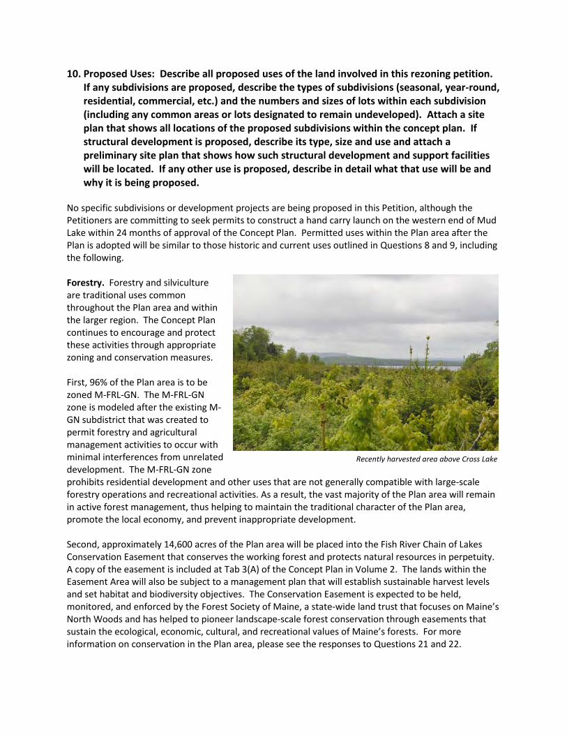
Forestry. Forestry and silviculture are traditional uses common throughout the Plan area and within the larger region. The Concept Plan continues to encourage and protect these activities through appropriate zoning and conservation measures. First, 96% of the Plan area is to be zoned M-FRL-GN. The M-FRL-GN zone is modeled after the existing M-GN subdistrict that was created to permit forestry and agricultural management activities to occur with minimal interferences from unrelated development. The M-FRL-GN zone prohibits residential development and other uses that are not generally compatible with large-scale forestry operations and recreational activities. As a result, the vast majority of the Plan area will remain in active forest management, thus helping to maintain the traditional character of the Plan area, promote the local economy, and prevent inappropriate development. Second, approximately 14,600 acres of the Plan area will be placed into the Fish River Chain of Lakes Conservation Easement that conserves the working forest and protects natural resources in perpetuity. A copy of the easement is included at Tab 3(A) of the Concept Plan in Volume 2. The lands within the Easement Area will also be subject to a management plan that will establish sustainable harvest levels and set habitat and biodiversity objectives. The Conservation Easement is expected to be held, monitored, and enforced by the Forest Society of Maine, a state-wide land trust that focuses on Maine’s North Woods and has helped to pioneer landscape-scale forest conservation through easements that sustain the ecological, economic, cultural, and recreational values of Maine’s forests. For more information on conservation in the Plan area, please see the responses to Questions 21 and 22.
Recently harvested area above Cross Lake
FISH RIVER CHAIN OF LAKES CONCEPT PLAN May 2017
2
VOLUME 1 – PETITION FOR REZONING Question 10 – Proposed Uses
Third, the Concept Plan mandates compliance with sustainable forestry practices throughout the Plan area. This includes implementing outcome based forestry (OBF) principles throughout the Plan area. The forestlands under OBF benefit from sustainability at a landscape scale perspective and the use of science-based approaches to measure agreed-upon outcomes for overall environmental, social and economic objectives. This includes best practices for water quality, wetlands, and riparian zones; soil productivity, timber supply and quality; aesthetic impacts; biodiversity; public accountability; economic and social considerations; and forest health. OBF forestry operations, which are authorized by statute, are subject to oversight by a technical review panel and an approved sustainable forestry certification program, such as the Sustainable Forestry Initiative or the Forest Stewardship Council Program, and thus subject to an independent third-party certification process. See the response to Question 20 for more information. Lastly, individual development areas created by the Concept Plan that are zoned D-FRL-CI, D-FRL-RF, D-FRL-GN, and D-FRL-RS may be rezoned automatically to M-FRL-GN upon the filing of a notice by the landowner. Given the 30-year term of the Concept Plan, this will ensure that development areas that are not being developed for any reason, such as the lack of market demand, can be returned efficiently to working forest through a zoning change, but only if the area in question has not been approved for any new development. Given the restrictive nature of M-FRL-GN zoning, and its prevalence throughout the Plan area, this process is consistent with and supportive of current zoning in the region.
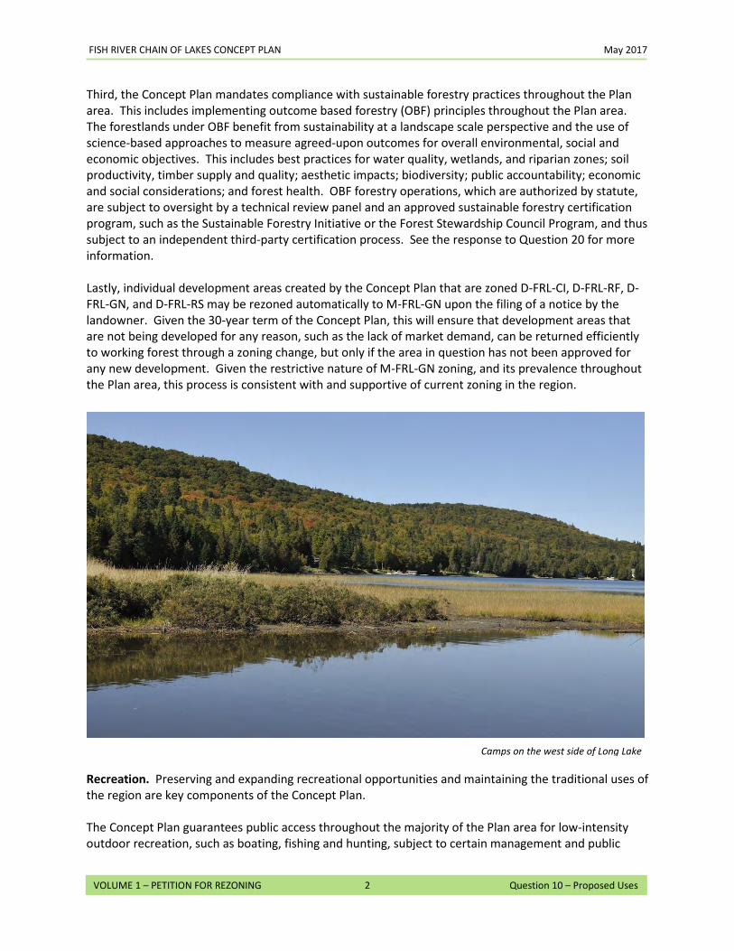
Recreation. Preserving and expanding recreational opportunities and maintaining the traditional uses of the region are key components of the Concept Plan. The Concept Plan guarantees public access throughout the majority of the Plan area for low-intensity outdoor recreation, such as boating, fishing and hunting, subject to certain management and public
Camps on the west side of Long Lake
FISH RIVER CHAIN OF LAKES CONCEPT PLAN May 2017
3
VOLUME 1 – PETITION FOR REZONING Question 10 – Proposed Uses
safety conditions. In addition, the Concept Plan continues to allow the managed use of ATVs and snowmobiles throughout the majority of the Plan area. The Conservation Easement allows all of these uses in perpetuity within the Easement Area, while maintaining the working forest and protecting its conservation values. The Concept Plan includes a specific development area – Square Lake Yerxas – that would allow for the establishment of a recreational lodging facility. This area is sited at the former Yerxas Camps in a cove on the eastern side of Square Lake. Permitted uses within this zone include development of a recreational lodging facility and associated amenities. This zone reflects many of the provisions of the existing D-RF subdistrict in Chapter 10. The most significant change, however, is that for ten years after the effective date of the Concept Plan, development of single and two-family dwellings or residential subdivisions require a special exception and will only be allowed if developed as part of a recreational lodging facility. These provisions are intended to promote development of a recreational lodging facility as a Hub for recreation in the Plan area, thus providing a diversity of ownership options for other residential uses, such as a hotel, condominium, or time-share. The Concept Plan also promotes traditional forms of recreation by allowing the development of remote rental cabins and campsites in the M-FRL-GN zone as part of a Hub, Spokes, and Rim system. The number and location of these facilities are limited in the zone, however, to ensure preservation of an appropriately remote recreation experience. For more information on the Hub, Spokes, and Rim system, and how it promotes recreational tourism, please see the response to Question 15. Also, see Maps 32 and 33 in Volume 3 for existing and potential recreational resources in the region Water Access. Access to the water bodies within the Plan area is an important aspect of its recreational heritage. The Concept Plan will improve equitable water access to the Fish River Chain of Lakes, while still limiting the impact on existing users and largely adopting the Chapter 10 standards, as follows:
• The beach at Van Buren Cove on Long Lake will remain a public access point. This area is currently used informally by camp owners and local residents for boating and swimming.
• Within 14 months of the Effective Date, Petitioners will amend the lease for the Cross Lake boat
launch, picnic area, and beach, to ensure that the public can use these facilities.
• A portion of the shorefront on each of Square Lake and Mud Lake will be zoned to allow for a water access site. There is currently no public access available on Mud Lake and limited public access available on Square Lake. The Northern Aroostook Regional Management Plan recognized the need for boat access to both lakes in the Strategic Plan for Providing Public Access to Maine Waters for Boating and Fishing, 1995 and 2000.1 The Maine Department of Inland Fisheries and Wildlife (Maine IF&W) has been seeking opportunities to provide “equitable access” to these lakes, as access is currently limited to those who either have or lease property
1 Strategic Plan for Providing Public Access to Maine Waters for Boating and Fishing, 1995 and 2000. Boating Facilities Program of the Maine Dept. of Agriculture, Conservation & Forestry, Maine Department of Inland Fisheries and Wildlife.
FISH RIVER CHAIN OF LAKES CONCEPT PLAN May 2017
4
VOLUME 1 – PETITION FOR REZONING Question 10 – Proposed Uses
on the lakes, or have boats that are small enough to enter the lakes during the summer months when water levels in the thoroughfares are low and passage is sometimes difficult.
• With respect to Mud Lake, the zoning will allow a hand carry launch at the western end of the
lake. The Petitioners will submit an application for the construction of a hand carry launch along with associated parking within 24 months of the effective date of the Concept Plan and the start of construction within 12 months of the approval of all applicable permits. (See Volume 3, Map 35, Mud Lake Water Access, for more detail.)
• With respect to Square Lake, the Concept Plan will zone Square Lake Yerxas and Square Lake E to allow development of up to three water access sites between them. Only one of these water access sites may be a trailered ramp. Further, to promote development of a public or commercial trailered ramp (which would be open to the public), any recreational lodging facility developed in Square Lake Yerxas would have to include a trailered ramp, unless such a ramp has already been permitted in the adjacent Square Lake E development area.
To balance the desire for equitable water access with the need to protect the scenic, aesthetic, and environmental quality of the lakes, the Concept Plan also restricts the number of new water access sites that can be developed to serve each development area. A water access site is a lot or common area primarily used for docking structures, hand carry launches and/or trailered ramps, and related facilities that provide common access to the water. By limiting the number of water access sites, the Concept Plan minimizes potential impacts to existing users and environmental systems, while promoting public access. Through amendments to Chapter 10, the Plan addresses compatibility issues that may arise by developing water access sites near existing residential areas. Key changes that pertain to water access sites include requiring vegetated or landscaped buffers at least 75 feet wide and sufficient to maintain an effective visual screen and protect water quality between any parking area and the water body served by the water access site and at least 20 feet wide and/or an architectural screen sufficient to maintain an effective visual screen to the greatest extent practicable between any parking area and side property lines of adjacent occupied lots. The revised standards would also limit the length of docking structures to be no longer than necessary. Finally, before development of a trailered ramp outside of Square Lake Yerxas or Square Lake E, an applicant will have to demonstrate that it is needed, based on, among other factors, the anticipated type and frequency of use, the anticipated need, and the potential impacts to the lake. This will help to ensure that access remains balanced with other interests. Residential. Seasonal camps and year-round homes are common throughout the Plan area. The Concept Plan addresses both existing and future residential uses. First, most of the existing or proposed residential development within the Plan area is located in a D-FRL-RS zone. This zone is based on the existing D-RS Subdistrict in Chapter 10, which was created to encourage the concentration of residential type development in and adjacent to existing residentially developed areas. The D-FRL-RS zone has been further modified to balance the needs of residential development with protection of the recreational and environmental resources of the Plan area by
FISH RIVER CHAIN OF LAKES CONCEPT PLAN May 2017
5
VOLUME 1 – PETITION FOR REZONING Question 10 – Proposed Uses
removing some of the uses permitted in the D-RS subdistrict (e.g., a trailed ramp would only be allowed by special exception and private trailered ramps would be prohibited). There are two other zones where residential development would be allowed – the D-FRL-RF zone and the D-FRL-GN zone. In the D-FRL-GN zone, residential use is only permitted as part of an affordable housing development and can only be approved as a special exception. Residential uses are permitted in the D-FRL-RF zone. However, for ten years after the Concept Plan takes effect, development of single and two-family residential dwellings or residential subdivisions may only be allowed in this zone by special exception and only if developed as part of a recreational lodging facility. These provisions are intended to promote development of a recreational lodging facility, thus providing a diversity of ownership options for residential uses, such as a hotel, condominium, or time share. Second, to manage the intensity of residential use in the Plan area, the Concept Plan allows for a limited amount of new residential development within specified areas, as shown on Map 21 in Volume 3. These residential areas are sized to allow flexibility in siting future roads and houses, while providing adequate room for common open spaces, buffers, trail corridors, and other amenities. This approach also provides developers the flexibility to minimize – or avoid altogether – adverse impacts to existing resources, some of which may not be fully mapped as part of this planning process (e.g., wetlands and vernal pools). Land in these new residential development areas that is not utilized in a specific development could be retained as part of the working forest or as part of a buffer to separate residential activities from adjacent forestry operations. The majority of these development areas are adjacent to existing residential development, as discussed in the response to Question 12.
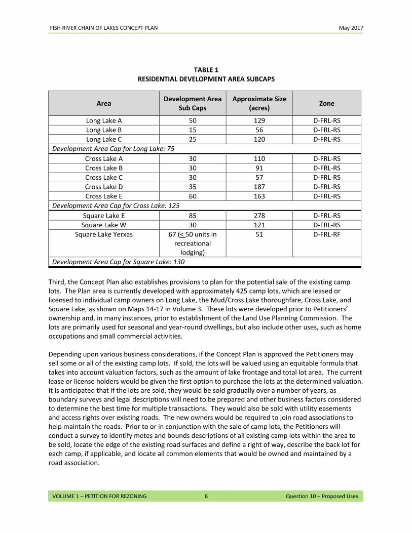
The total number of new development units (referred to as units) within the proposed residential development areas (including Square Lake Yerxas) is capped at 330. In addition, a maximum number of units (known as the Development Area Cap) is established for each of the three lakes where residential development will be allowed: Long Lake (75 units), Cross Lake (125 units), and Square Lake (130 units). Each specific development area also has a cap on the number of units (development area sub cap) that will be allowed. These development area sub caps are established to allow flexibility in developing units on a given lake, provided the overall development cap for that lake is not exceeded. Final layout of subdivision lots and structures will be guided by the land use standards established in the Chapter 10 Addendum, as well as any other applicable standards in effect at the time.
FISH RIVER CHAIN OF LAKES CONCEPT PLAN May 2017
6
VOLUME 1 – PETITION FOR REZONING Question 10 – Proposed Uses
Third, the Concept Plan also establishes provisions to plan for the potential sale of the existing camp lots. The Plan area is currently developed with approximately 425 camp lots, which are leased or licensed to individual camp owners on Long Lake, the Mud/Cross Lake thoroughfare, Cross Lake, and Square Lake, as shown on Maps 14-17 in Volume 3. These lots were developed prior to Petitioners’ ownership and, in many instances, prior to establishment of the Land Use Planning Commission. The lots are primarily used for seasonal and year-round dwellings, but also include other uses, such as home occupations and small commercial activities. Depending upon various business considerations, if the Concept Plan is approved the Petitioners may sell some or all of the existing camp lots. If sold, the lots will be valued using an equitable formula that takes into account valuation factors, such as the amount of lake frontage and total lot area. The current lease or license holders would be given the first option to purchase the lots at the determined valuation. It is anticipated that if the lots are sold, they would be sold gradually over a number of years, as boundary surveys and legal descriptions will need to be prepared and other business factors considered to determine the best time for multiple transactions. They would also be sold with utility easements and access rights over existing roads. The new owners would be required to join road associations to help maintain the roads. Prior to or in conjunction with the sale of camp lots, the Petitioners will conduct a survey to identify metes and bounds descriptions of all existing camp lots within the area to be sold, locate the edge of the existing road surfaces and define a right of way, describe the back lot for each camp, if applicable, and locate all common elements that would be owned and maintained by a road association.
Area Development Area Sub Caps
Approximate Size (acres) Zone
Long Lake A 50 129 D-FRL-RS Long Lake B 15 56 D-FRL-RS Long Lake C 25 120 D-FRL-RS
Development Area Cap for Long Lake: 75 Cross Lake A 30 110 D-FRL-RS Cross Lake B 30 91 D-FRL-RS Cross Lake C 30 57 D-FRL-RS Cross Lake D 35 187 D-FRL-RS Cross Lake E 60 163 D-FRL-RS
Development Area Cap for Cross Lake: 125 Square Lake E 85 278 D-FRL-RS Square Lake W 30 121 D-FRL-RS
Square Lake Yerxas 67 (< 50 units in recreational
lodging)
51 D-FRL-RF
Development Area Cap for Square Lake: 130
TABLE 1 RESIDENTIAL DEVELOPMENT AREA SUBCAPS
FISH RIVER CHAIN OF LAKES CONCEPT PLAN May 2017
7
VOLUME 1 – PETITION FOR REZONING Question 10 – Proposed Uses
Many of the camp lots are located in close proximity to waterbodies, are frequently nonconforming with current standards, and have less-then-ideal soils. Therefore, if sold, the Concept Plan would require that the majority of the camp lots will be expanded to include some additional land, referred to as a back lot. This additional land will make the camp lots less nonconforming and could be used for a variety of purposes, including siting replacement subsurface waste water systems outside the shoreland zone. Furthermore, if adequate soils cannot be located on either the original camp lot or the new back lot, in most cases the landowner will be required to make available sufficient rights to site replacement subsurface waste water systems in back lands that may be located within 400 feet of the shoreline and up to 2,500 feet of the nearest boundary of the camp lot. This process will substantially improve the odds of locating suitable soils in areas farther from the lake and outside the shoreland zone than current rules would allow, thereby allowing for potentially beneficial redevelopment of camp lots, while providing greater protection of water quality in the Fish River Chain of Lakes.2 Community and Economic Development Uses. As noted in the response to Question 9, the region is comprised of a diversity of business and commercial uses. Another component of the Concept Plan is to provide opportunities for continued economic growth in the northern Aroostook County region.
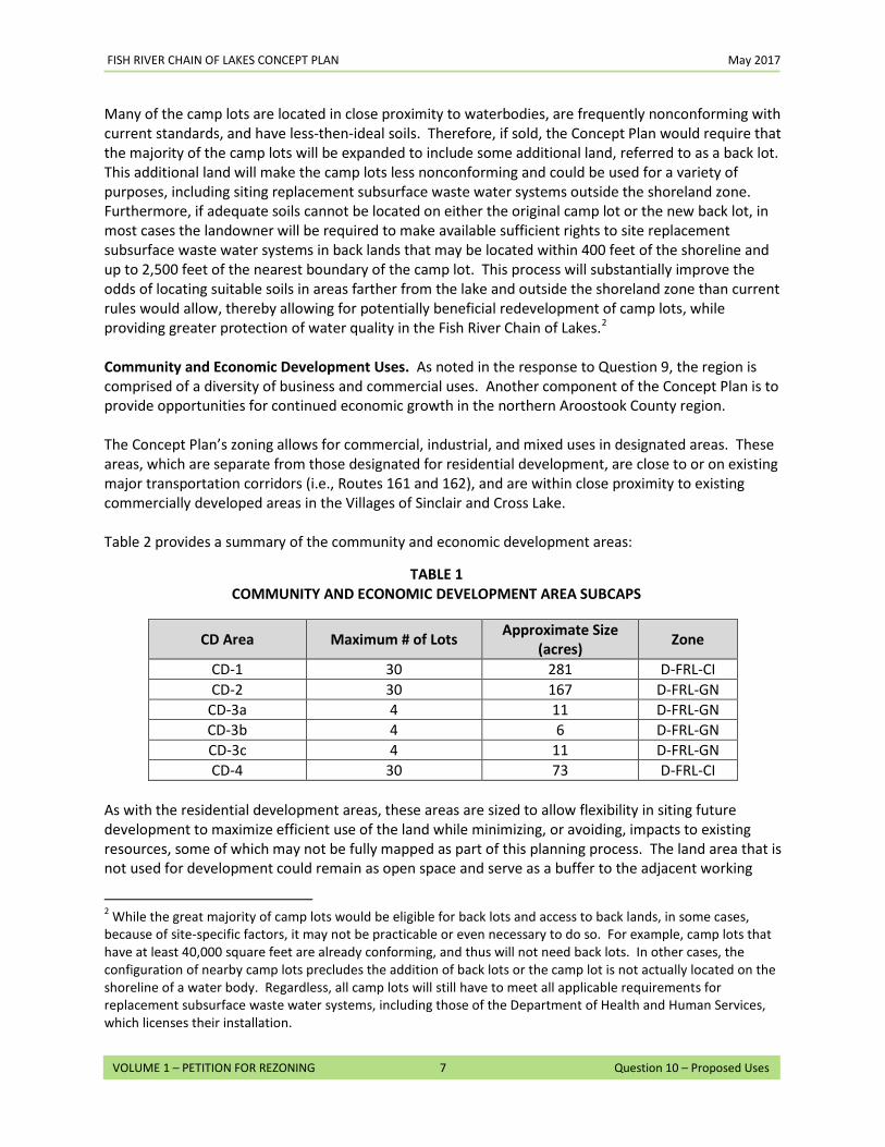
The Concept Plan’s zoning allows for commercial, industrial, and mixed uses in designated areas. These areas, which are separate from those designated for residential development, are close to or on existing major transportation corridors (i.e., Routes 161 and 162), and are within close proximity to existing commercially developed areas in the Villages of Sinclair and Cross Lake.
Table 2 provides a summary of the community and economic development areas:
CD Area Maximum # of Lots Approximate Size (acres) Zone
CD-1 30 281 D-FRL-CI CD-2 30 167 D-FRL-GN
CD-3a 4 11 D-FRL-GN CD-3b 4 6 D-FRL-GN CD-3c 4 11 D-FRL-GN CD-4 30 73 D-FRL-CI
As with the residential development areas, these areas are sized to allow flexibility in siting future development to maximize efficient use of the land while minimizing, or avoiding, impacts to existing resources, some of which may not be fully mapped as part of this planning process. The land area that is not used for development could remain as open space and serve as a buffer to the adjacent working
2 While the great majority of camp lots would be eligible for back lots and access to back lands, in some cases, because of site-specific factors, it may not be practicable or even necessary to do so. For example, camp lots that have at least 40,000 square feet are already conforming, and thus will not need back lots. In other cases, the configuration of nearby camp lots precludes the addition of back lots or the camp lot is not actually located on the shoreline of a water body. Regardless, all camp lots will still have to meet all applicable requirements for replacement subsurface waste water systems, including those of the Department of Health and Human Services, which licenses their installation.
TABLE 1 COMMUNITY AND ECONOMIC DEVELOPMENT AREA SUBCAPS
FISH RIVER CHAIN OF LAKES CONCEPT PLAN May 2017
8
VOLUME 1 – PETITION FOR REZONING Question 10 – Proposed Uses
forest or neighbors, or it could be reserved for additional uses. See Maps 23 and 24 in Volume 3 for the location of these development areas. Two of these areas – identified as CD-1 and CD-4 – are zoned D-FRL-CI. This zone reflects most of the same uses as allowed under the D-CI zone in the current Chapter 10. However, several uses that would otherwise be permitted have been prohibited, including recreational lodging facilities and trailered ramps, in an effort to minimize conflicts cause by incompatible uses and to better promote commercial and industrial uses in these development areas. The other areas – CD-2, CD-3a, CD-3b, and CD-3c – are zoned D-FRL-GN. This zone also reflects the same uses as allowed under the D-GN zone in the current Chapter 10, but likewise prohibits several uses that would otherwise be allowed, such as single, two-, and multi-family dwellings. Several of these areas – CD-2, CD-3a, CD-3b, and CD-3c – are adjacent to locations outside the Plan area that are already zoned as D-GN. Also, CD-1 and CD-2 are in close proximity to the waste water treatment plant in Sinclair, which may be beneficial for future development, depending upon arrangements with the treatment authority. To help address site specific conditions and to better reduce potential conflicts with incompatible uses, the D-FRL-CI and D-FRL-GN zones also require buffer strips, setbacks, and maximum building heights. CD-1, CD-2, and CD-4 also do not allow more than 50% of the total area to be developed.
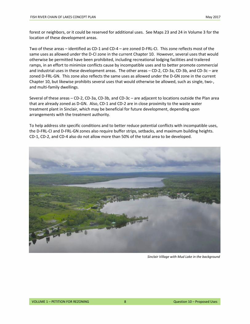
Sinclair Village with Mud Lake in the background
11. Consistency with Comprehensive Plan: The Commission’s plan includes specific goals to guide the location of new development; to protect and conserve forest, recreational, plant or animal habitat and other natural resources; to ensure the compatibility of land uses with one another; and to allow for a reasonable range of development opportunities important to the people of Maine.
A. PRINCIPAL VALUES
The Land Use Planning Commission (LUPC) has identified four principal values in Section 1.1 of the Comprehensive Land Use Plan (CLUP) that, taken together, define the distinctive character of the jurisdiction:
• The economic value of the jurisdiction derived from working forests and farmlands,
including fiber and food production, largely on private lands. This value is based primarily on maintenance of forest resources and the economic health of the forest products industry.
• Diverse and abundant recreational opportunities, including many types of motorized and non-motorized activities. Unique opportunities exist for recreational activities that require or are significantly enhanced by large stretches of undeveloped land, ranging from primitive recreation in certain locations to extensive motorized trail networks. Recreation is increasingly an economic driver in the jurisdiction and the State.
• Diverse, abundant and unique high-value natural resources and features, including lakes, rivers and other water resources, fish and wildlife resources, plants and natural communities, scenic and cultural resources, coastal islands, mountain areas and other geologic resources.
• Natural character, which includes the uniqueness of a vast forested area that is largely undeveloped and remote from population centers. Remoteness and the relative absence of development in large parts of the jurisdiction are perhaps the most distinctive of the jurisdiction’s principal values, due mainly to their increasing rarity in the Northeastern United States. These values may be difficult to quantify but they are integral to the jurisdiction’s identity and to its overall character.
The Concept Plan has been developed to promote these principal values. The Concept Plan integrates sound planning practices that will maintain and enhance the traditional forest economy, promote recreational and traditional uses, provide a unique opportunity to maintain and expand recreational activity through the Hub, Spokes and Rim concept, protect critical natural areas, and guide future development to appropriate locations in order to maintain the natural character of the Fish River Chain of Lakes. How the Concept Plan promotes each of these values is discussed in greater detail below.
FISH RIVER CHAIN OF LAKES CONCEPT PLAN May 2017
2
VOLUME 1 – PETITION FOR REZONING Question 11 – Consistency with Comprehensive Plan
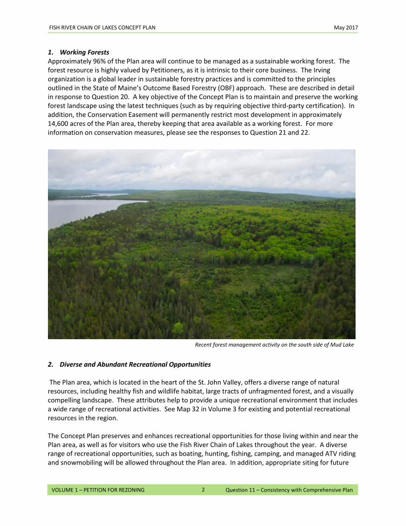
1. Working Forests Approximately 96% of the Plan area will continue to be managed as a sustainable working forest. The forest resource is highly valued by Petitioners, as it is intrinsic to their core business. The Irving organization is a global leader in sustainable forestry practices and is committed to the principles outlined in the State of Maine’s Outcome Based Forestry (OBF) approach. These are described in detail in response to Question 20. A key objective of the Concept Plan is to maintain and preserve the working forest landscape using the latest techniques (such as by requiring objective third-party certification). In addition, the Conservation Easement will permanently restrict most development in approximately 14,600 acres of the Plan area, thereby keeping that area available as a working forest. For more information on conservation measures, please see the responses to Question 21 and 22.
2. Diverse and Abundant Recreational Opportunities The Plan area, which is located in the heart of the St. John Valley, offers a diverse range of natural resources, including healthy fish and wildlife habitat, large tracts of unfragmented forest, and a visually compelling landscape. These attributes help to provide a unique recreational environment that includes a wide range of recreational activities. See Map 32 in Volume 3 for existing and potential recreational resources in the region. The Concept Plan preserves and enhances recreational opportunities for those living within and near the Plan area, as well as for visitors who use the Fish River Chain of Lakes throughout the year. A diverse range of recreational opportunities, such as boating, hunting, fishing, camping, and managed ATV riding and snowmobiling will be allowed throughout the Plan area. In addition, appropriate siting for future
Recent forest management activity on the south side of Mud Lake
FISH RIVER CHAIN OF LAKES CONCEPT PLAN May 2017
3
VOLUME 1 – PETITION FOR REZONING Question 11 – Consistency with Comprehensive Plan
growth and development areas, combined with sustainable forestry practices and the proposed 14,600-acre Conservation Easement, will protect the natural resources that are fundamental to providing the setting for diverse and abundant recreational activities. As discussed in greater detail in response to Question 10, certain parts of the Plan area will be zoned to not only maintain public access to the lakes, but also to create opportunities for new access points on Mud Lake and Square Lake, thereby helping to meet goals set by the Maine Department of Inland Fisheries and Wildlife (IF&W) to improve public access to these waterbodies. Petitioners have specifically committed to providing a hand carry launch on Mud Lake, subject to permitting, and to amending the lease to the existing private boat ramp, picnic area, and beach on Cross Lake, currently leased to a private group, to require that the facility be available to the public. The diverse and abundant recreational opportunities that are characteristic of the Plan area make it well suited to nature-based tourism and for a destination tourism facility. Recreational lodging opportunities centered around the historic Yerxas Camps would likely promote and capitalize on the wide variety of recreational opportunities in the Plan area, while supporting the regional economy. As discussed in response to Question 15, the Yerxas Camps would serve as the anchor development in a Hub, Spokes and Rim system that takes advantage of remote rental cabins, remote campsites, cultural activities in surrounding communities, and existing business and services. These amenities are all readily connected by land and water. The new community and economic development areas will also provide opportunities for a variety of businesses, including those that specialize in recreational activities, such as guides and outfitters, to capitalize on these recreational activities and offer complimentary services and amenities.
3. Diverse, Abundant, and Unique High-Value Natural Resources
Petitioners actively protect biodiversity and scientifically and ecologically significant features throughout their land holdings. This includes areas that are notable for aesthetics, wildlife habitats, old-growth and high conservation forests, unique forest stands, lakes, wetlands, rare or uncommon plant species, historic sites, and geological and fossil sites. These areas are identified and cataloged through the Irving organization’s innovative Unique Areas Program, which was voluntarily established in 1996. The Unique Areas Program was created to help:
• Preserve rare and uncommon species and significant landscape features; • Preserve “indicator” species that can be used to monitor natural or man-made changes in the
environment; • Establish a database that aids scientists and policymakers in determining the abundance and
distribution of species and natural features; • Formulate better management plans for unique areas; and • Educate the public about forest and resource management and invite its support in identifying
significant sites.
The planning process for the Concept Plan began at the landscape level using information from the Unique Areas Program and data from state agencies such as Maine Natural Areas Program (MNAP). Using this information, development areas were then sited to avoid and minimize impacts to areas of
FISH RIVER CHAIN OF LAKES CONCEPT PLAN May 2017
4
VOLUME 1 – PETITION FOR REZONING Question 11 – Consistency with Comprehensive Plan
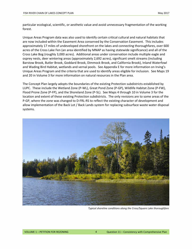
particular ecological, scientific, or aesthetic value and avoid unnecessary fragmentation of the working forest. Unique Areas Program data was also used to identify certain critical cultural and natural habitats that are now included within the Easement Area conserved by the Conservation Easement. This includes approximately 17 miles of undeveloped shorefront on the lakes and connecting thoroughfares, over 600 acres of the Cross Lake Fen (an area identified by MNAP as having statewide significance) and all of the Cross Lake Bog (roughly 3,000 acres). Additional areas under conservation include multiple eagle and osprey nests, deer wintering areas (approximately 2,692 acres), significant smelt streams (including Barstow Brook, Butler Brook, Goddard Brook, Dimmock Brook, and California Brook), Inland Waterfowl and Wading Bird Habitat, wetlands and vernal pools. See Appendix E for more information on Irving’s Unique Areas Program and the criteria that are used to identify areas eligible for inclusion. See Maps 19 and 20 in Volume 3 for more information on natural resources in the Plan area. The Concept Plan largely adopts the boundaries of the existing Protection subdistricts established by LUPC. These include the Wetland Zone (P-WL), Great Pond Zone (P-GP), Wildlife Habitat Zone (P-FW), Flood Prone Zone (P-FP), and the Shoreland Zone (P-SL). See Maps 4 through 10 in Volume 3 for the location and extent of these existing Protection subdistricts. The only revisions are to some areas of the P-GP, where the zone was changed to D-FRL-RS to reflect the existing character of development and allow implementation of the Back Lot / Back Lands system for replacing subsurface waste water disposal systems.
Typical shoreline conditions along the Cross/Square Lake thoroughfare
FISH RIVER CHAIN OF LAKES CONCEPT PLAN May 2017
5
VOLUME 1 – PETITION FOR REZONING Question 11 – Consistency with Comprehensive Plan
4. Natural Character
The Concept Plan permits a diverse range of development opportunities without compromising the natural character of the Plan area. As noted above, areas for future development were identified by using several sources of data (Unique Areas Program, MNAP, state mapping, and other sources) that provided data at a landscape level, which allowed areas of working forest and high natural, scenic and recreational resource values to be identified and avoided. This analysis also identified existing patterns and locations of development within the Plan area and surrounding communities. The majority of the new residential development areas have been located adjacent to similar existing development and in locations where natural resource impacts can be avoided or minimized. In the case of Square Lake E, the development area was sited near the previously-developed sporting camp (Yerxas Camp,) which is currently located within a D-GN subdistrict. The areas zoned to permit community and economic development were similarly sited near existing commercial activity, or mixed-use patterns of development, and accessible to major roads and other public infrastructure. If the Concept Plan is approved, any future development will be required to follow a set of standards that are based on the existing Chapter 10 rules. These standards are incorporated into the Concept Plan in the Chapter 10 Addendum. See Tab 2(D) of the Concept Plan in Volume 2. The Chapter 10 Addendum largely incorporates the development standards of the existing Chapter 10, but makes multiple key revisions that will help to preserve and protect the natural character of the Plan area. Among these revisions are:
• New requirements to help minimize visual impacts of commercial development by requiring buffering, screening and larger setbacks.
• Additional limitations on the density of development in community and economic development areas.
• Reductions in the maximum height standards for structures in all development areas. • Further restrictions on exterior lighting for residential lighting to protect the night sky. • New requirements for setbacks and buffers around communal water access sites and associated
parking areas. • Strict limitations on the number of new water access sites, including, in particular, a
requirement to demonstrate need before any new trailered ramps can be approved for Long Lake and Cross Lake.
B. GOALS AND POLICIES
As a means of promoting its principal values, the CLUP includes a series of specific goals and policies in Section 1.2 that guide the location of new development; protect and conserve forest, recreational, plant or animal habitat and other natural resources; ensure the compatibility of land uses with one another; and allow for a reasonable range of development opportunities. The discussion below identifies how specific goals and policies are supported by the Concept Plan, with a cross-reference to a discussion in this Petition for more information.
FISH RIVER CHAIN OF LAKES CONCEPT PLAN May 2017
6
VOLUME 1 – PETITION FOR REZONING Question 11 – Consistency with Comprehensive Plan
Location of Development – CLUP Section 1.2,I,A
Goal: Guide the location of new development in order to protect and conserve forest, recreational, plant or animal habitat and other natural resources, to ensure the compatibility of land uses with one another and to allow for a reasonable range of development opportunities important to the people of Maine, including property owners and residents of the unorganized and deorganized townships.
Policies re: location of development on a jurisdiction-wide level
Proposed Concept Plan Action Location in Petition by Question #
• Provide for a sustainable pattern of development, consistent with historical patterns, which directs development to suitable areas and retains the principal values of the jurisdiction, including a working forest, integrity of natural resources, and remoteness.
• Proposed development areas were sited to be adjacent to existing development or (in the case of Square Lake E and Square Lake Yerxas), near historical development, leaving the majority of the Plan area as unfragmented working forest and preserving the integrity of natural resources within the Plan area.
• The Plan also limits the amount of overall development that can occur throughout the Plan area and further specifies the amount of development that can occur within each development area.
9, 10, 12, 13, 14, 15, 21
• Guide development to areas near existing towns and communities and in other areas identified as appropriate development centers.
• The Concept Plan identifies new residential and community/economic development areas adjacent to the villages of Cross Lake and Sinclair. These new development areas allow for growth of these existing centers with minimal construction of new road networks to gain access.
• The only areas requiring a waiver of the adjacency principle (Square Lake Yerxas and Square Lake E) are in and near existing D-GN zoning for an historic sporting camp and are protected from harmful secondary development through comparable conservation.
8, 9, 12, 13, 17, 20, 21
FISH RIVER CHAIN OF LAKES CONCEPT PLAN May 2017
7
VOLUME 1 – PETITION FOR REZONING Question 11 – Consistency with Comprehensive Plan
Policies re: location of development on a community or regional level
Proposed Concept Plan Action Location in Petition by Question #
• Encourage orderly growth within and proximate to existing, compatibly developed areas — i.e., existing development of similar type, use, occupancy, scale and intensity to that being proposed, or a village center with a range of uses for which the proposed development will provide complementary services, goods, jobs and/or housing.
• New residential development areas are generally located adjacent to existing similarly developed areas. The scale and intensity of any future development is further managed through appropriate Development Area Caps that limit the number of residential units that can be developed to 330 in the residential development areas.
• CD-2, CD-3a, CD-3b, and CD-3c are located on major roads in areas that are adjacent to existing village areas or centers of commercial activity. Permitting uses in these areas will provide opportunities for goods or services as well as jobs that are complementary to the adjacent areas or fit within the context of the larger plan area of region.
• CD-1 and CD-4, which are also located on or near major access routes, are sited to permit a wider range of commercial uses that benefit from access to roads and existing public infrastructure without worrying about incompatible uses.
9, 12, 13, 14, 15, 17, 21
• Permit subdivision for the purpose of development only in areas zoned for development or in areas that meet the criteria for Level 2 subdivisions.
• The Concept Plan permits residential subdivisions only in areas designated for development.
10, 19
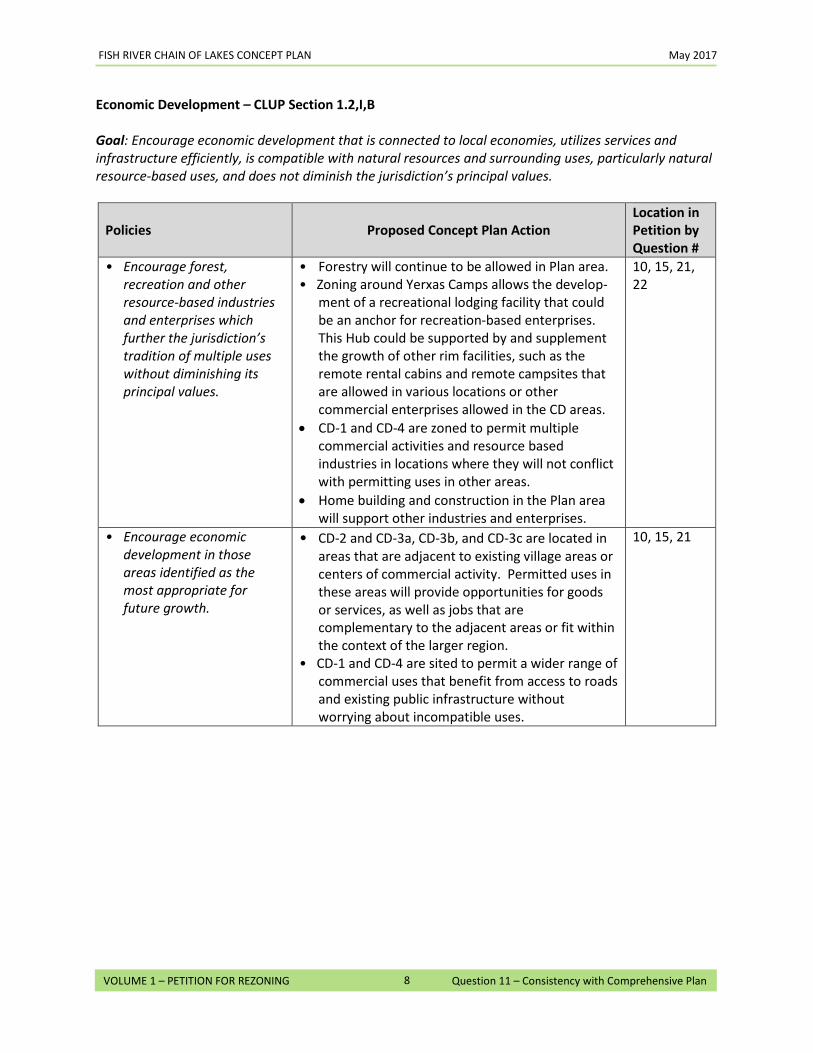
FISH RIVER CHAIN OF LAKES CONCEPT PLAN May 2017
8
VOLUME 1 – PETITION FOR REZONING Question 11 – Consistency with Comprehensive Plan
Economic Development – CLUP Section 1.2,I,B Goal: Encourage economic development that is connected to local economies, utilizes services and infrastructure efficiently, is compatible with natural resources and surrounding uses, particularly natural resource-based uses, and does not diminish the jurisdiction’s principal values.
Policies Proposed Concept Plan Action Location in Petition by Question #
• Encourage forest, recreation and other resource-based industries and enterprises which further the jurisdiction’s tradition of multiple uses without diminishing its principal values.
• Forestry will continue to be allowed in Plan area. • Zoning around Yerxas Camps allows the develop-
ment of a recreational lodging facility that could be an anchor for recreation-based enterprises. This Hub could be supported by and supplement the growth of other rim facilities, such as the remote rental cabins and remote campsites that are allowed in various locations or other commercial enterprises allowed in the CD areas.
• CD-1 and CD-4 are zoned to permit multiple commercial activities and resource based industries in locations where they will not conflict with permitting uses in other areas.
• Home building and construction in the Plan area will support other industries and enterprises.
10, 15, 21, 22
• Encourage economic development in those areas identified as the most appropriate for future growth.
• CD-2 and CD-3a, CD-3b, and CD-3c are located in areas that are adjacent to existing village areas or centers of commercial activity. Permitted uses in these areas will provide opportunities for goods or services, as well as jobs that are complementary to the adjacent areas or fit within the context of the larger region.
• CD-1 and CD-4 are sited to permit a wider range of commercial uses that benefit from access to roads and existing public infrastructure without worrying about incompatible uses.
10, 15, 21
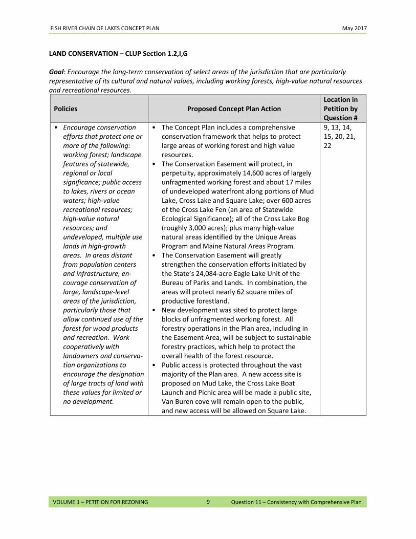
FISH RIVER CHAIN OF LAKES CONCEPT PLAN May 2017
9
VOLUME 1 – PETITION FOR REZONING Question 11 – Consistency with Comprehensive Plan
LAND CONSERVATION – CLUP Section 1.2,I,G
Goal: Encourage the long-term conservation of select areas of the jurisdiction that are particularly representative of its cultural and natural values, including working forests, high-value natural resources and recreational resources.
Policies Proposed Concept Plan Action Location in Petition by Question #
• Encourage conservation efforts that protect one or more of the following: working forest; landscape features of statewide, regional or local significance; public access to lakes, rivers or ocean waters; high-value recreational resources; high-value natural resources; and undeveloped, multiple use lands in high-growth areas. In areas distant from population centers and infrastructure, en-courage conservation of large, landscape-level areas of the jurisdiction, particularly those that allow continued use of the forest for wood products and recreation. Work cooperatively with landowners and conserva-tion organizations to encourage the designation of large tracts of land with these values for limited or no development.
• The Concept Plan includes a comprehensive conservation framework that helps to protect large areas of working forest and high value resources.
• The Conservation Easement will protect, in perpetuity, approximately 14,600 acres of largely unfragmented working forest and about 17 miles of undeveloped waterfront along portions of Mud Lake, Cross Lake and Square Lake; over 600 acres of the Cross Lake Fen (an area of Statewide Ecological Significance); all of the Cross Lake Bog (roughly 3,000 acres); plus many high-value natural areas identified by the Unique Areas Program and Maine Natural Areas Program.
• The Conservation Easement will greatly strengthen the conservation efforts initiated by the State’s 24,084-acre Eagle Lake Unit of the Bureau of Parks and Lands. In combination, the areas will protect nearly 62 square miles of productive forestland.
• New development was sited to protect large blocks of unfragmented working forest. All forestry operations in the Plan area, including in the Easement Area, will be subject to sustainable forestry practices, which help to protect the overall health of the forest resource.
• Public access is protected throughout the vast majority of the Plan area. A new access site is proposed on Mud Lake, the Cross Lake Boat Launch and Picnic area will be made a public site, Van Buren cove will remain open to the public, and new access will be allowed on Square Lake.
9, 13, 14, 15, 20, 21, 22
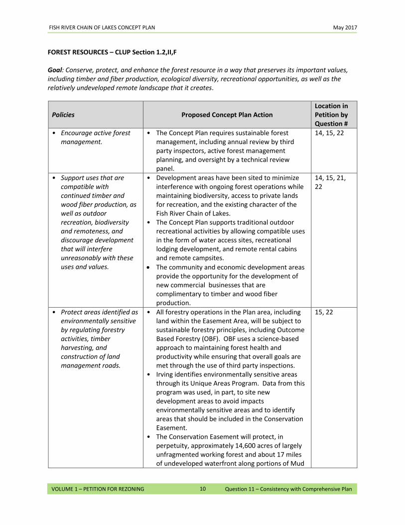
FISH RIVER CHAIN OF LAKES CONCEPT PLAN May 2017
10
VOLUME 1 – PETITION FOR REZONING Question 11 – Consistency with Comprehensive Plan
FOREST RESOURCES – CLUP Section 1.2,II,F
Goal: Conserve, protect, and enhance the forest resource in a way that preserves its important values, including timber and fiber production, ecological diversity, recreational opportunities, as well as the relatively undeveloped remote landscape that it creates.
Policies Proposed Concept Plan Action Location in Petition by Question #
• Encourage active forest management.
• The Concept Plan requires sustainable forest management, including annual review by third party inspectors, active forest management planning, and oversight by a technical review panel.
14, 15, 22
• Support uses that are compatible with continued timber and wood fiber production, as well as outdoor recreation, biodiversity and remoteness, and discourage development that will interfere unreasonably with these uses and values.
• Development areas have been sited to minimize interference with ongoing forest operations while maintaining biodiversity, access to private lands for recreation, and the existing character of the Fish River Chain of Lakes.
• The Concept Plan supports traditional outdoor recreational activities by allowing compatible uses in the form of water access sites, recreational lodging development, and remote rental cabins and remote campsites.
• The community and economic development areas provide the opportunity for the development of new commercial businesses that are complimentary to timber and wood fiber production.
14, 15, 21, 22
• Protect areas identified as environmentally sensitive by regulating forestry activities, timber harvesting, and construction of land management roads.
• All forestry operations in the Plan area, including land within the Easement Area, will be subject to sustainable forestry principles, including Outcome Based Forestry (OBF). OBF uses a science-based approach to maintaining forest health and productivity while ensuring that overall goals are met through the use of third party inspections.
• Irving identifies environmentally sensitive areas through its Unique Areas Program. Data from this program was used, in part, to site new development areas to avoid impacts environmentally sensitive areas and to identify areas that should be included in the Conservation Easement.
• The Conservation Easement will protect, in perpetuity, approximately 14,600 acres of largely unfragmented working forest and about 17 miles of undeveloped waterfront along portions of Mud
15, 22
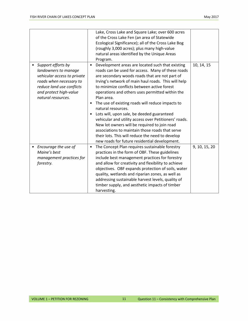
FISH RIVER CHAIN OF LAKES CONCEPT PLAN May 2017
11
VOLUME 1 – PETITION FOR REZONING Question 11 – Consistency with Comprehensive Plan
Lake, Cross Lake and Square Lake; over 600 acres of the Cross Lake Fen (an area of Statewide Ecological Significance); all of the Cross Lake Bog (roughly 3,000 acres); plus many high-value natural areas identified by the Unique Areas Program.
• Support efforts by landowners to manage vehicular access to private roads when necessary to reduce land use conflicts and protect high-value natural resources.
• Development areas are located such that existing roads can be used for access. Many of these roads are secondary woods roads that are not part of Irving’s network of main haul roads. This will help to minimize conflicts between active forest operations and others uses permitted within the Plan area.
• The use of existing roads will reduce impacts to natural resources.
• Lots will, upon sale, be deeded guaranteed vehicular and utility access over Petitioners’ roads. New lot owners will be required to join road associations to maintain those roads that serve their lots. This will reduce the need to develop new roads for future residential development.
10, 14, 15
• Encourage the use of Maine’s best management practices for forestry.
• The Concept Plan requires sustainable forestry practices in the form of OBF. These guidelines include best management practices for forestry and allow for creativity and flexibility to achieve objectives. OBF expands protection of soils, water quality, wetlands and riparian zones, as well as addressing sustainable harvest levels, quality of timber supply, and aesthetic impacts of timber harvesting.
9, 10, 15, 20
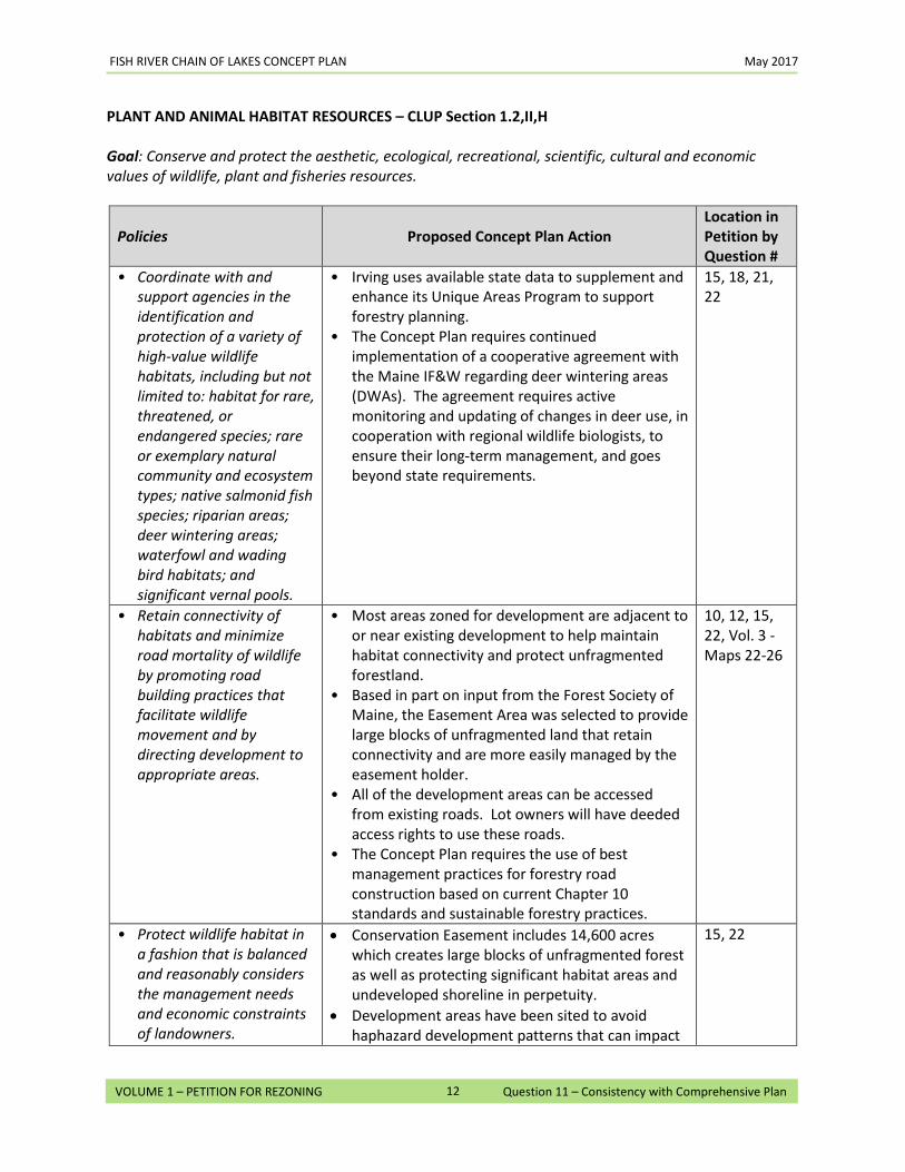
FISH RIVER CHAIN OF LAKES CONCEPT PLAN May 2017
12
VOLUME 1 – PETITION FOR REZONING Question 11 – Consistency with Comprehensive Plan
PLANT AND ANIMAL HABITAT RESOURCES – CLUP Section 1.2,II,H
Goal: Conserve and protect the aesthetic, ecological, recreational, scientific, cultural and economic values of wildlife, plant and fisheries resources.
Policies Proposed Concept Plan Action Location in Petition by Question #
• Coordinate with and support agencies in the identification and protection of a variety of high-value wildlife habitats, including but not limited to: habitat for rare, threatened, or endangered species; rare or exemplary natural community and ecosystem types; native salmonid fish species; riparian areas; deer wintering areas; waterfowl and wading bird habitats; and significant vernal pools.
• Irving uses available state data to supplement and enhance its Unique Areas Program to support forestry planning.
• The Concept Plan requires continued implementation of a cooperative agreement with the Maine IF&W regarding deer wintering areas (DWAs). The agreement requires active monitoring and updating of changes in deer use, in cooperation with regional wildlife biologists, to ensure their long-term management, and goes beyond state requirements.
15, 18, 21, 22
• Retain connectivity of habitats and minimize road mortality of wildlife by promoting road building practices that facilitate wildlife movement and by directing development to appropriate areas.
• Most areas zoned for development are adjacent to or near existing development to help maintain habitat connectivity and protect unfragmented forestland.
• Based in part on input from the Forest Society of Maine, the Easement Area was selected to provide large blocks of unfragmented land that retain connectivity and are more easily managed by the easement holder.
• All of the development areas can be accessed from existing roads. Lot owners will have deeded access rights to use these roads.
• The Concept Plan requires the use of best management practices for forestry road construction based on current Chapter 10 standards and sustainable forestry practices.
10, 12, 15, 22, Vol. 3 - Maps 22-26
• Protect wildlife habitat in a fashion that is balanced and reasonably considers the management needs and economic constraints of landowners.
• Conservation Easement includes 14,600 acres which creates large blocks of unfragmented forest as well as protecting significant habitat areas and undeveloped shoreline in perpetuity.
• Development areas have been sited to avoid haphazard development patterns that can impact
15, 22
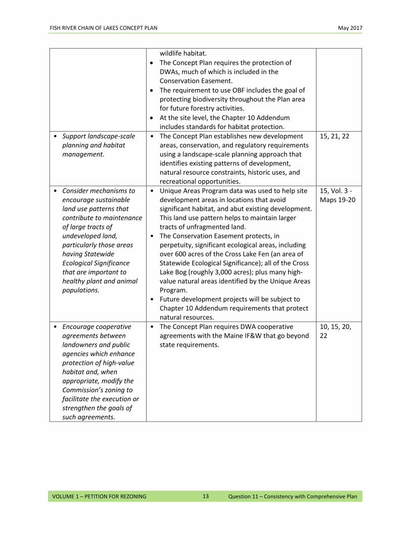
FISH RIVER CHAIN OF LAKES CONCEPT PLAN May 2017
13
VOLUME 1 – PETITION FOR REZONING Question 11 – Consistency with Comprehensive Plan
wildlife habitat. • The Concept Plan requires the protection of
DWAs, much of which is included in the Conservation Easement.
• The requirement to use OBF includes the goal of protecting biodiversity throughout the Plan area for future forestry activities.
• At the site level, the Chapter 10 Addendum includes standards for habitat protection.
• Support landscape-scale planning and habitat management.
• The Concept Plan establishes new development areas, conservation, and regulatory requirements using a landscape-scale planning approach that identifies existing patterns of development, natural resource constraints, historic uses, and recreational opportunities.
15, 21, 22
• Consider mechanisms to encourage sustainable land use patterns that contribute to maintenance of large tracts of undeveloped land, particularly those areas having Statewide Ecological Significance that are important to healthy plant and animal populations.
• Unique Areas Program data was used to help site development areas in locations that avoid significant habitat, and abut existing development. This land use pattern helps to maintain larger tracts of unfragmented land.
• The Conservation Easement protects, in perpetuity, significant ecological areas, including over 600 acres of the Cross Lake Fen (an area of Statewide Ecological Significance); all of the Cross Lake Bog (roughly 3,000 acres); plus many high-value natural areas identified by the Unique Areas Program.
• Future development projects will be subject to Chapter 10 Addendum requirements that protect natural resources.
15, Vol. 3 - Maps 19-20
• Encourage cooperative agreements between landowners and public agencies which enhance protection of high-value habitat and, when appropriate, modify the Commission’s zoning to facilitate the execution or strengthen the goals of such agreements.
• The Concept Plan requires DWA cooperative agreements with the Maine IF&W that go beyond state requirements.
10, 15, 20, 22
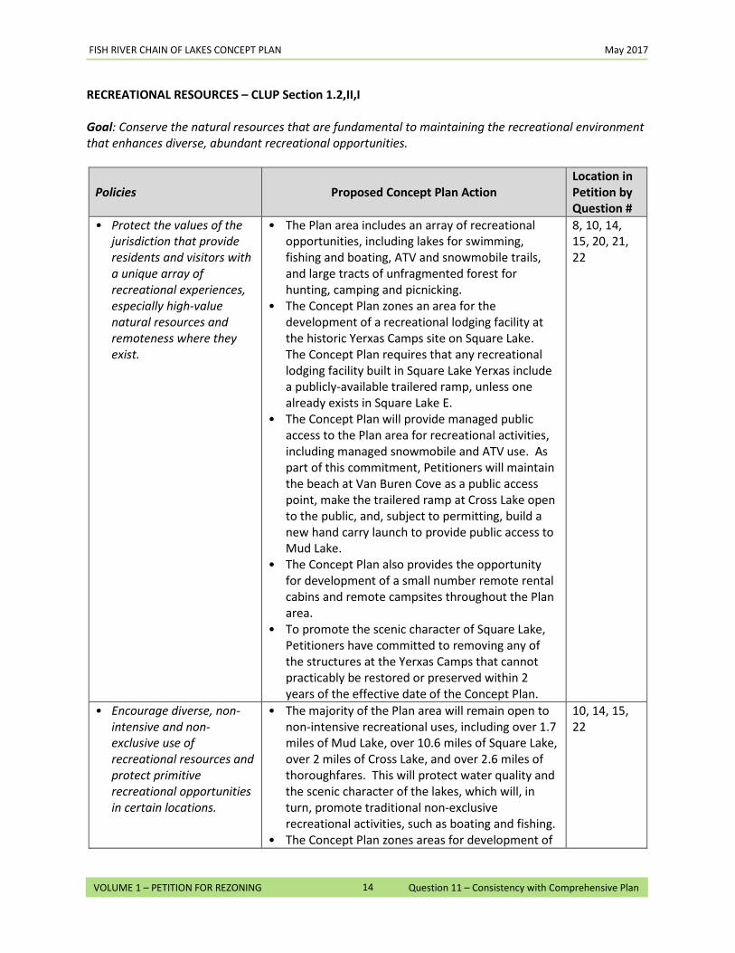
FISH RIVER CHAIN OF LAKES CONCEPT PLAN May 2017
14
VOLUME 1 – PETITION FOR REZONING Question 11 – Consistency with Comprehensive Plan
RECREATIONAL RESOURCES – CLUP Section 1.2,II,I
Goal: Conserve the natural resources that are fundamental to maintaining the recreational environment that enhances diverse, abundant recreational opportunities.
Policies Proposed Concept Plan Action Location in Petition by Question #
• Protect the values of the jurisdiction that provide residents and visitors with a unique array of recreational experiences, especially high-value natural resources and remoteness where they exist.
• The Plan area includes an array of recreational opportunities, including lakes for swimming, fishing and boating, ATV and snowmobile trails, and large tracts of unfragmented forest for hunting, camping and picnicking.
• The Concept Plan zones an area for the development of a recreational lodging facility at the historic Yerxas Camps site on Square Lake. The Concept Plan requires that any recreational lodging facility built in Square Lake Yerxas include a publicly-available trailered ramp, unless one already exists in Square Lake E.
• The Concept Plan will provide managed public access to the Plan area for recreational activities, including managed snowmobile and ATV use. As part of this commitment, Petitioners will maintain the beach at Van Buren Cove as a public access point, make the trailered ramp at Cross Lake open to the public, and, subject to permitting, build a new hand carry launch to provide public access to Mud Lake.
• The Concept Plan also provides the opportunity for development of a small number remote rental cabins and remote campsites throughout the Plan area.
• To promote the scenic character of Square Lake, Petitioners have committed to removing any of the structures at the Yerxas Camps that cannot practicably be restored or preserved within 2 years of the effective date of the Concept Plan.
8, 10, 14, 15, 20, 21, 22
• Encourage diverse, non-intensive and non-exclusive use of recreational resources and protect primitive recreational opportunities in certain locations.
• The majority of the Plan area will remain open to non-intensive recreational uses, including over 1.7 miles of Mud Lake, over 10.6 miles of Square Lake, over 2 miles of Cross Lake, and over 2.6 miles of thoroughfares. This will protect water quality and the scenic character of the lakes, which will, in turn, promote traditional non-exclusive recreational activities, such as boating and fishing.
• The Concept Plan zones areas for development of
10, 14, 15, 22
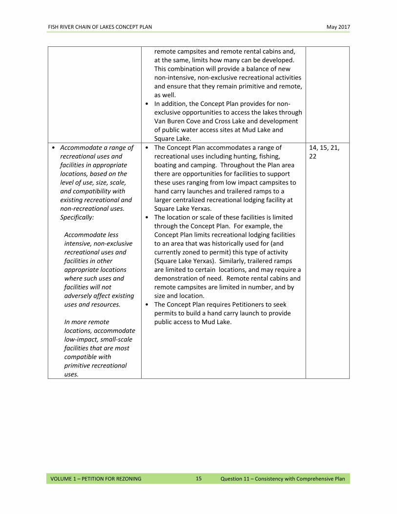
FISH RIVER CHAIN OF LAKES CONCEPT PLAN May 2017
15
VOLUME 1 – PETITION FOR REZONING Question 11 – Consistency with Comprehensive Plan
remote campsites and remote rental cabins and, at the same, limits how many can be developed. This combination will provide a balance of new non-intensive, non-exclusive recreational activities and ensure that they remain primitive and remote, as well.
• In addition, the Concept Plan provides for non-exclusive opportunities to access the lakes through Van Buren Cove and Cross Lake and development of public water access sites at Mud Lake and Square Lake.
• Accommodate a range of recreational uses and facilities in appropriate locations, based on the level of use, size, scale, and compatibility with existing recreational and non-recreational uses. Specifically:
Accommodate less intensive, non-exclusive recreational uses and facilities in other appropriate locations where such uses and facilities will not adversely affect existing uses and resources. In more remote locations, accommodate low-impact, small-scale facilities that are most compatible with primitive recreational uses.
• The Concept Plan accommodates a range of recreational uses including hunting, fishing, boating and camping. Throughout the Plan area there are opportunities for facilities to support these uses ranging from low impact campsites to hand carry launches and trailered ramps to a larger centralized recreational lodging facility at Square Lake Yerxas.
• The location or scale of these facilities is limited through the Concept Plan. For example, the Concept Plan limits recreational lodging facilities to an area that was historically used for (and currently zoned to permit) this type of activity (Square Lake Yerxas). Similarly, trailered ramps are limited to certain locations, and may require a demonstration of need. Remote rental cabins and remote campsites are limited in number, and by size and location.
• The Concept Plan requires Petitioners to seek permits to build a hand carry launch to provide public access to Mud Lake.
14, 15, 21, 22
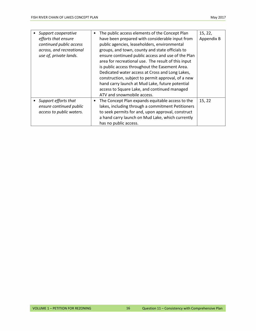
FISH RIVER CHAIN OF LAKES CONCEPT PLAN May 2017
16
VOLUME 1 – PETITION FOR REZONING Question 11 – Consistency with Comprehensive Plan
• Support cooperative efforts that ensure continued public access across, and recreational use of, private lands.
• The public access elements of the Concept Plan have been prepared with considerable input from public agencies, leaseholders, environmental groups, and town, county and state officials to ensure continued public access and use of the Plan area for recreational use. The result of this input is public access throughout the Easement Area. Dedicated water access at Cross and Long Lakes, construction, subject to permit approval, of a new hand carry launch at Mud Lake, future potential access to Square Lake, and continued managed ATV and snowmobile access.
15, 22, Appendix B
• Support efforts that ensure continued public access to public waters.
• The Concept Plan expands equitable access to the lakes, including through a commitment Petitioners to seek permits for and, upon approval, construct a hand carry launch on Mud Lake, which currently has no public access.
15, 22
FISH RIVER CHAIN OF LAKES CONCEPT PLAN May 2017
17
VOLUME 1 – PETITION FOR REZONING Question 11 – Consistency with Comprehensive Plan
SCENIC RESOURCES – CLUP Section 1.2,II,J
Goal: Protect the high-value scenic resources of the jurisdiction by fitting proposed land uses harmoniously into the natural environment.
Policies Proposed Concept Plan Action Location in Petition by Question #
• Encourage concentrated patterns of growth to minimize impacts on natural values and scenic character.
• The Concept Plan concentrates much of the allowable development in only 4% of the Plan area. The majority of residential and community and economic development areas are in close proximity to existing development, preserving extensive lengths of shoreline.
• In new development areas, structures will be minimally visible from waterbodies.
• OBF principles include consideration of aesthetics when planning and conducting harvest activities.
18, 19, 22
• Regulate land uses generally in order to protect natural aesthetic values and prevent the incompatibility of land uses.
• Residential and community and economic development areas are sited to avoid conflicts with incompatible uses. In addition, new develop-ment areas include more land than is needed for the anticipated number of units, so a considerable area will be left as common open space or unde-veloped to provide privacy and protect natural resources.
• Forestry and forest management activities will be guided by sustainable forestry practices, which include managing aesthetic impacts of harvesting.
• New development in community and economic development areas and water access sites will require preservation and maintenance of buffers and setbacks to limit visual impacts on neighbors.
• Although zoning in the development areas largely reflects current Chapter 10 zoning, some uses have been prohibited to prevent incompatible uses, including in the M-FRL-GN district that covers approximately 96% of the Plan area, recreational lodging facilities, single and two-family homes, certain solid waste disposal facilities, and home occupations.
14, 15, 18, 19, 20
• Continue to regulate timber harvesting acti-vities in important recre-ational and scenic areas to protect aesthetic qualities.
• Forestry and forest management activities will be guided by sustainable OBF forestry practices, which include consideration of the aesthetic impact of timber harvesting.
14, 15
FISH RIVER CHAIN OF LAKES CONCEPT PLAN May 2017
18
VOLUME 1 – PETITION FOR REZONING Question 11 – Consistency with Comprehensive Plan
WATER RESOURCES – CLUP Section 1.2,II,K Goal: Preserve, protect, and enhance the quality and quantity of surface waters and groundwater.
Policies Proposed Concept Plan Action Location in Petition by Question #
• Regulate uses of land and water in order to prevent degradation of the jurisdiction’s excellent water quality and undue harm to aquatic habitat.
• The Concept Plan adopts the Chapter 10 standards for land use, shoreline setbacks, and clearing limits to protect water quality and aquatic habitat.
• The Concept Plan makes land available for most camp lots that will assist in allowing replacement septic systems to be sited in locations father away from waterbodies, outside of 250’ shoreland zone.
14, 15, 18
• Protect the recreational and aesthetic values associated with water resources.
• The Concept Plan will conserve about 17 miles of shoreline on lakes and thoroughfares. This is approximately 67% of the existing undeveloped shoreline and over 49% of the total shoreline within the Plan area.
• Forestry and forest management activities will be guided by sustainable forestry practices, which include OBF principles that manage the aesthetic impact of timber harvesting.
• Concept Plan restricts the number of new water access sites that can be developed to serve residential development areas to ensure appropriate levels of additional recreational use of lakes.
• For any new development that is allowed along the shoreline, the Concept Plan includes structural setback requirements, clearing limits and buffering standards.
14, 15, 22
• Conserve and protect lakes, ponds, rivers, streams, and their shorelands, which provide significant public recreational opportunities.
• The Concept Plan will conserve about 17 miles of shoreline on Mud, Cross, and Square Lakes and their thoroughfares, including many areas with significant recreational opportunities.
• Forestry activities within the Plan area will adhere to sustainable forestry practices, which include policies for harvesting within the riparian zone that meet or exceed state standards.
14, 15, 22
• Permit a reasonable range of development and land uses on lakeshores in order to accommodate a range of recreational opportunities important to Maine people.
• The Concept Plan includes a range of development and land uses, including a recreational lodging facility, remote campsites, remote rental cabins, picnic areas, water access sites, residential development and commercial development. However, new development is concentrated in only a small portion of the Plan area.
14, 15, 22
FISH RIVER CHAIN OF LAKES CONCEPT PLAN May 2017
19
VOLUME 1 – PETITION FOR REZONING Question 11 – Consistency with Comprehensive Plan
• The majority of the Plan area will be accessible for traditional recreational uses, including managed snowmobile and ATV use.
• The Concept Plan achieves a conservation-to-development ratio for miles of shoreline of approximately 6:1 on Square Lake.
• The Concept Plan restricts the number of new water access sites that can be developed to serve the residential development areas to ensure appropriate levels of additional recreational use of the lakes.
• Require appropriate setbacks and other development standards to protect water quality, water quantity, and the recreational and aesthetic values of lakes and rivers.
• The Concept Plan adopts the Chapter 10 standards for shoreline setbacks and clearing limits. It also places limits on the number of water access sites and includes standards for development of such facilities.
• The Concept Plan makes land available for most camp lots that will assist in allowing replacement septic systems to be sited in locations father away from waterbodies and outside the 250’ shoreland zone.
14, 15, 19
• Guide lake development based on identified land use characteristics and natural resource values, conserving important values and directing development toward those lakes or lake areas most capable of absorbing new development.
• Development areas were sited using historic land use characteristics and patterns, identified natural resources, and the soils reports.
14
• Protect lake water quality from long-term and cumulative increases in phosphorus associated with development in lake watersheds.
• The Concept Plan has been developed with input from the Maine Department of Environmental Protection on allowable phosphorus loading on each of the lakes included in the Plan area. Modeling demonstrates that levels of phosphorus discharged from maximum potential development would be below allowable limits.
14
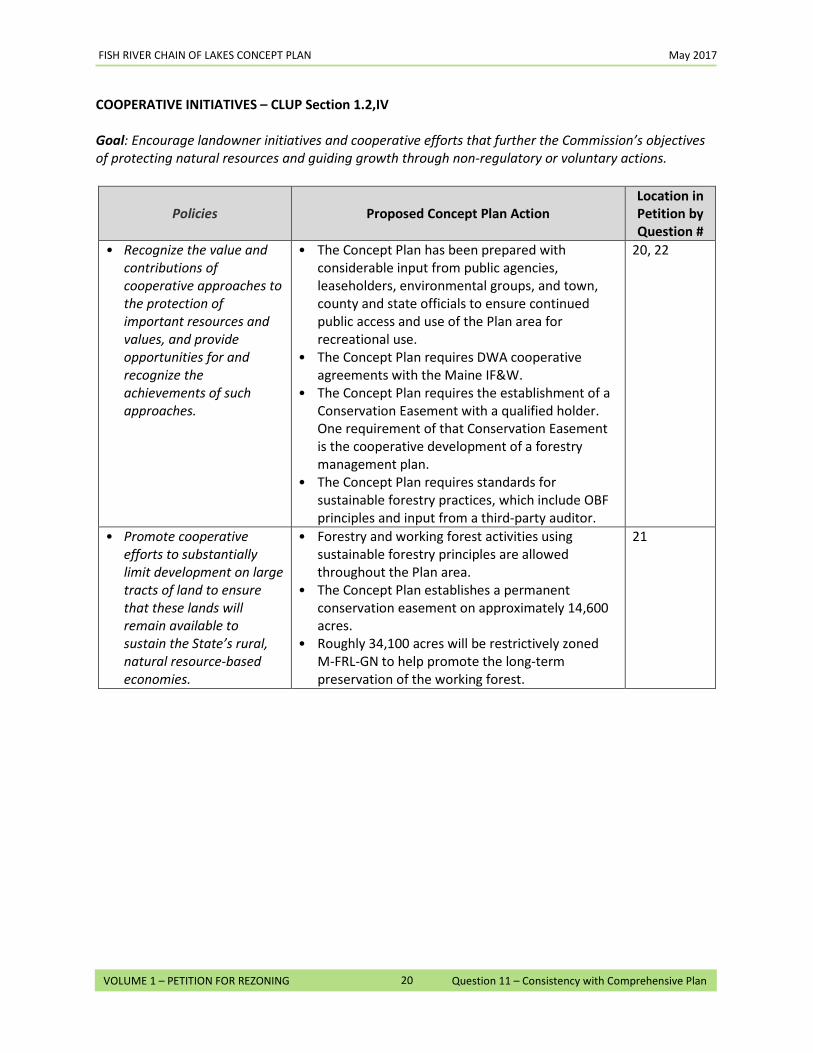
FISH RIVER CHAIN OF LAKES CONCEPT PLAN May 2017
20
VOLUME 1 – PETITION FOR REZONING Question 11 – Consistency with Comprehensive Plan
COOPERATIVE INITIATIVES – CLUP Section 1.2,IV
Goal: Encourage landowner initiatives and cooperative efforts that further the Commission’s objectives of protecting natural resources and guiding growth through non-regulatory or voluntary actions.
Policies Proposed Concept Plan Action Location in Petition by Question #
• Recognize the value and contributions of cooperative approaches to the protection of important resources and values, and provide opportunities for and recognize the achievements of such approaches.
• The Concept Plan has been prepared with considerable input from public agencies, leaseholders, environmental groups, and town, county and state officials to ensure continued public access and use of the Plan area for recreational use.
• The Concept Plan requires DWA cooperative agreements with the Maine IF&W.
• The Concept Plan requires the establishment of a Conservation Easement with a qualified holder. One requirement of that Conservation Easement is the cooperative development of a forestry management plan.
• The Concept Plan requires standards for sustainable forestry practices, which include OBF principles and input from a third-party auditor.
20, 22
• Promote cooperative efforts to substantially limit development on large tracts of land to ensure that these lands will remain available to sustain the State’s rural, natural resource-based economies.
• Forestry and working forest activities using sustainable forestry principles are allowed throughout the Plan area.
• The Concept Plan establishes a permanent conservation easement on approximately 14,600 acres.
• Roughly 34,100 acres will be restrictively zoned M-FRL-GN to help promote the long-term preservation of the working forest.
21

12. Adjacency Criteria: The Commission’s plan encourages orderly growth within and proximate to existing, compatible developed areas. This is referred to as the “adjacency” criterion. When considering any petition for rezoning, the Commission places considerable weight on this objective. However, the Commission may consider adjusting the adjacency criterion when assessing concept plans, provided any such relaxation is matched by comparable conservation measures. Does your proposal fit the adjacency objective? If so, describe in detail the type and amount of existing nearby development. Include the distance (by straight line and by road) of such development from your proposed area(s) of development.
Within the Plan area, the majority of the new development areas are consistent with the “adjacency” criterion because they are located less than one road mile from existing, compatible development. The application of the adjacency criteria for each of the development areas identified in this Concept Plan is addressed both in the narrative discussion below and in the summary table that follows. Long Lake. All of the new development areas proposed on Long Lake meet the adjacency criterion because they are either adjacent to or within 500 feet of existing compatible developed areas.
• Long Lake A is adjacent to existing residential lots on East Van Buren Cove Road. See Map 22 in Volume 3. There are approximately 115 lots within a one-mile radius of Long Lake A. These include lots on the west side of Long Lake. Zoning for Long Lake A will be consistent with the residential zoning on adjacent developed areas and allow for residential uses to be developed.
• Long Lake B is located immediately upland of existing residential lots on West Van Buren Cove Road. See Map 22 in Volume 3. There are approximately 150 lots within a one-mile radius of Long Lake B, including lots on the east side of Long Lake. Zoning for Long Lake B will be consistent with the residential zoning on adjacent developed areas and allow for residential uses to be developed.
• Long Lake C is located within 500 feet of the existing privately-owned waterfront lots at the end of Barnbrook Road, east of the Village of Sinclair. See Map 23 in Volume 3. There are approximately 75 lots within a one-mile radius of Long Lake C. Zoning for Long Lake C will be consistent with the residential zoning on the adjacent developed areas along the lakefront and allow for residential uses to be developed.
Cross Lake. All of the new development areas on Cross Lake meet the adjacency criterion because they are either adjacent to or within 500 feet of existing compatible developed areas, within one mile over existing roads from existing compatible developed areas, or within one road mile of existing compatible developed areas if a road were to be constructed.
• Cross Lake A is located within 500 feet of existing residential lots on the west side of Cross Lake. See Map 24 in Volume 3. There are approximately 140 lots within a one-mile radius of Cross Lake A. Zoning for Cross Lake A will be consistent with the residential zoning on adjacent developed areas and allow for residential uses to be developed.
• Cross Lake B is adjacent to existing residential lots on the northeast side of Cross Lake. See Map
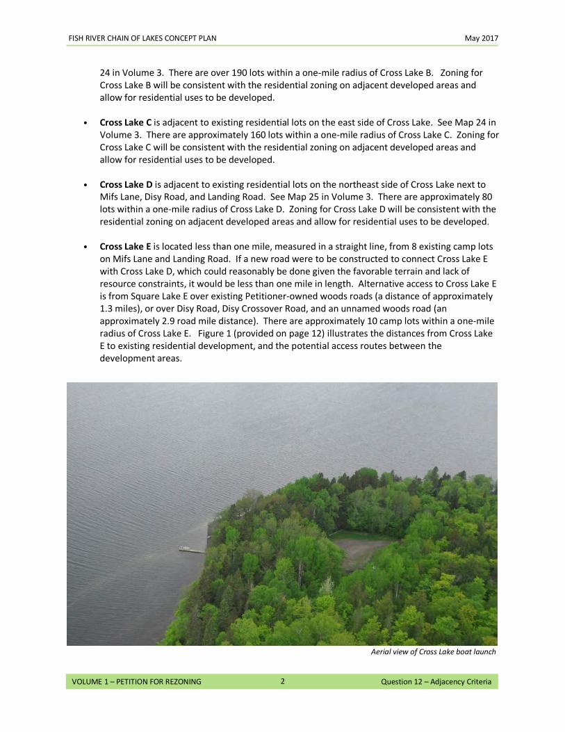
FISH RIVER CHAIN OF LAKES CONCEPT PLAN May 2017
2
VOLUME 1 – PETITION FOR REZONING Question 12 – Adjacency Criteria
24 in Volume 3. There are over 190 lots within a one-mile radius of Cross Lake B. Zoning for Cross Lake B will be consistent with the residential zoning on adjacent developed areas and allow for residential uses to be developed.
• Cross Lake C is adjacent to existing residential lots on the east side of Cross Lake. See Map 24 in Volume 3. There are approximately 160 lots within a one-mile radius of Cross Lake C. Zoning for Cross Lake C will be consistent with the residential zoning on adjacent developed areas and allow for residential uses to be developed.
• Cross Lake D is adjacent to existing residential lots on the northeast side of Cross Lake next to Mifs Lane, Disy Road, and Landing Road. See Map 25 in Volume 3. There are approximately 80 lots within a one-mile radius of Cross Lake D. Zoning for Cross Lake D will be consistent with the residential zoning on adjacent developed areas and allow for residential uses to be developed.
• Cross Lake E is located less than one mile, measured in a straight line, from 8 existing camp lots on Mifs Lane and Landing Road. If a new road were to be constructed to connect Cross Lake E with Cross Lake D, which could reasonably be done given the favorable terrain and lack of resource constraints, it would be less than one mile in length. Alternative access to Cross Lake E is from Square Lake E over existing Petitioner-owned woods roads (a distance of approximately 1.3 miles), or over Disy Road, Disy Crossover Road, and an unnamed woods road (an approximately 2.9 road mile distance). There are approximately 10 camp lots within a one-mile radius of Cross Lake E. Figure 1 (provided on page 12) illustrates the distances from Cross Lake E to existing residential development, and the potential access routes between the development areas.
Aerial view of Cross Lake boat launch
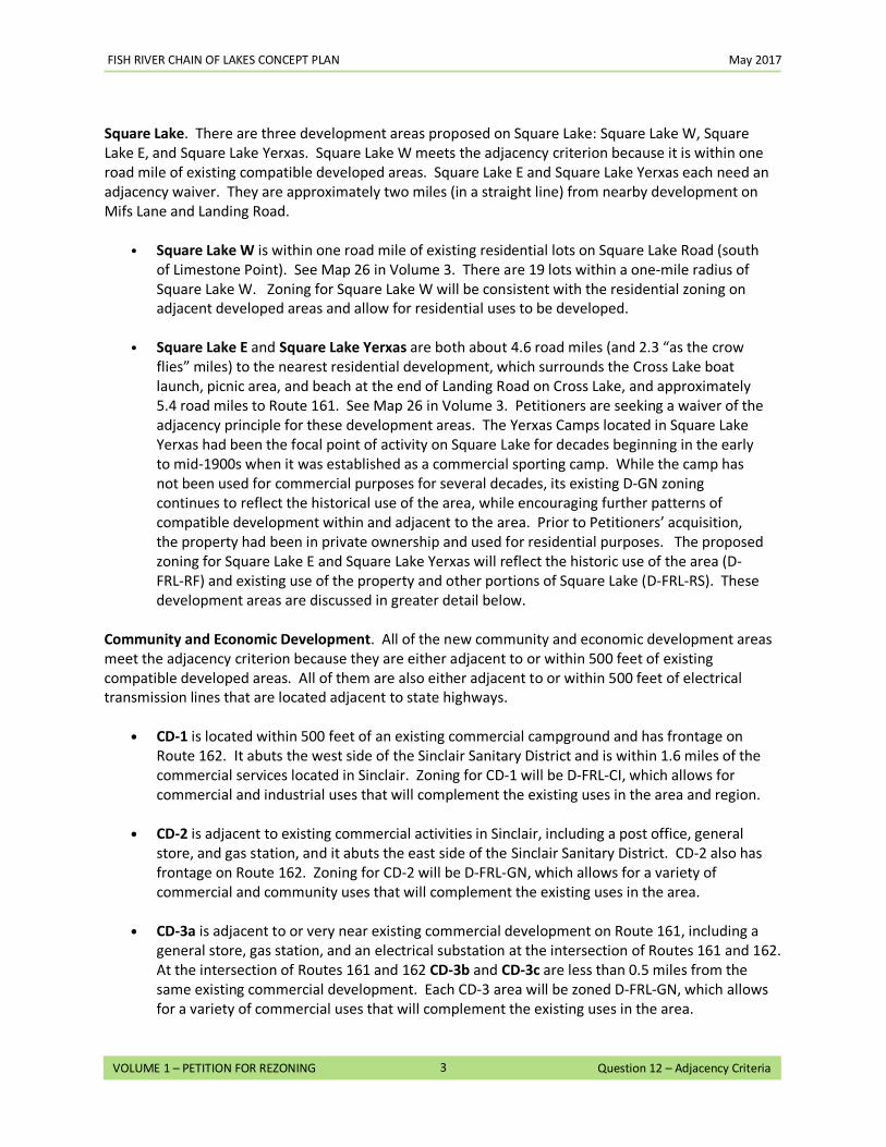
FISH RIVER CHAIN OF LAKES CONCEPT PLAN May 2017
3
VOLUME 1 – PETITION FOR REZONING Question 12 – Adjacency Criteria
Square Lake. There are three development areas proposed on Square Lake: Square Lake W, Square Lake E, and Square Lake Yerxas. Square Lake W meets the adjacency criterion because it is within one road mile of existing compatible developed areas. Square Lake E and Square Lake Yerxas each need an adjacency waiver. They are approximately two miles (in a straight line) from nearby development on Mifs Lane and Landing Road.
• Square Lake W is within one road mile of existing residential lots on Square Lake Road (south of Limestone Point). See Map 26 in Volume 3. There are 19 lots within a one-mile radius of Square Lake W. Zoning for Square Lake W will be consistent with the residential zoning on adjacent developed areas and allow for residential uses to be developed.
• Square Lake E and Square Lake Yerxas are both about 4.6 road miles (and 2.3 “as the crow flies” miles) to the nearest residential development, which surrounds the Cross Lake boat launch, picnic area, and beach at the end of Landing Road on Cross Lake, and approximately 5.4 road miles to Route 161. See Map 26 in Volume 3. Petitioners are seeking a waiver of the adjacency principle for these development areas. The Yerxas Camps located in Square Lake Yerxas had been the focal point of activity on Square Lake for decades beginning in the early to mid-1900s when it was established as a commercial sporting camp. While the camp has not been used for commercial purposes for several decades, its existing D-GN zoning continues to reflect the historical use of the area, while encouraging further patterns of compatible development within and adjacent to the area. Prior to Petitioners’ acquisition, the property had been in private ownership and used for residential purposes. The proposed zoning for Square Lake E and Square Lake Yerxas will reflect the historic use of the area (D-FRL-RF) and existing use of the property and other portions of Square Lake (D-FRL-RS). These development areas are discussed in greater detail below.
Community and Economic Development. All of the new community and economic development areas meet the adjacency criterion because they are either adjacent to or within 500 feet of existing compatible developed areas. All of them are also either adjacent to or within 500 feet of electrical transmission lines that are located adjacent to state highways.
• CD-1 is located within 500 feet of an existing commercial campground and has frontage on
Route 162. It abuts the west side of the Sinclair Sanitary District and is within 1.6 miles of the commercial services located in Sinclair. Zoning for CD-1 will be D-FRL-CI, which allows for commercial and industrial uses that will complement the existing uses in the area and region.
• CD-2 is adjacent to existing commercial activities in Sinclair, including a post office, general store, and gas station, and it abuts the east side of the Sinclair Sanitary District. CD-2 also has frontage on Route 162. Zoning for CD-2 will be D-FRL-GN, which allows for a variety of commercial and community uses that will complement the existing uses in the area.
• CD-3a is adjacent to or very near existing commercial development on Route 161, including a general store, gas station, and an electrical substation at the intersection of Routes 161 and 162. At the intersection of Routes 161 and 162 CD-3b and CD-3c are less than 0.5 miles from the same existing commercial development. Each CD-3 area will be zoned D-FRL-GN, which allows for a variety of commercial uses that will complement the existing uses in the area.
FISH RIVER CHAIN OF LAKES CONCEPT PLAN May 2017
4
VOLUME 1 – PETITION FOR REZONING Question 12 – Adjacency Criteria
• CD-4 is located less than 0.5 miles east of the existing commercial development on Route 161 and is immediately adjacent to a recently installed electrical substation at the intersection of Routes 161 and 162. Its southern boundary is the transmission line located on the north side of Route 161. Zoning for CD-4 will be D-FRL-CI, which allows for commercial and industrial uses.
TABLE 1 SUMMARY OF ADJACENCY
Proposed Development
Area
Straight Line Distance to
Nearest Development
Distance to Nearest Development Using
Existing Roads
Type & Amount of Nearest Existing Development in Straight
Line
Long Lake A Within 500’ of camp lots on east side of Long Lake
Within 500’ of East Van Buren Cove Road
Adjacent to D-RS zone. Approx. 110 camp lots within 1 mile. See Map 22 in Vol 3.
Long Lake B Within 500’ of camp lots on west side of Long Lake
Adjacent to West Van Buren Cove Road
Adjacent to D-RS zone. Approx. 150 camp lots within 1 mile. See Map 22 in Vol 3.
Long Lake C Within 500’ of private homes on Barnbrook Road
7.0± miles, following Knockout Hill Road to Van Buren Cove; or approximately 0.25 miles over adjacent land outside Plan area to gain access from Barnbrook Road.
Within 0.1 mile of D-RS zone. Approx. 75 camp lots within 1 mile. See Map 23 in Vol 3.
Cross Lake A Within 500’ of camp lots on west side of Cross Lake
Adjacent to West Side Road/Shoreline Drive
Adjacent to D-RS zone. Approx. 140 camp lots within 1 mile on West Side Road. See Map 24 in Vol 3.
Cross Lake B Within 500’ of camp lots on northeast side of Cross Lake
Adjacent to Route 161 and crossed by Windy Cove Road, Shady Lane, Duck Cove Road, Cormier Road, May Road, Sandy Point Road, Garcelon Road, Copper Road, Cote Road, and Manzer Road.
Adjacent to D-RS zone. Over 190 camp lots within 1 mile. See Map 24 in Vol 3.
Cross Lake C Within 500’ of camp lots on east side of Cross Lake
Adjacent to Cyr Road Adjacent to D-RS zone. Approx. 160 camp lots within 1 mile on Cyr Road, Huntress Road, Route 161, and Mifs Lane. See Map 24 in Vol 3.
Cross Lake D Within 500’ of lots on east side of Cross Lake
Adjacent to Mifs Lane, Disy Road, and Landing Road
Adjacent to D-RS zone. Approx. 80 camp lots within 1 mile on Cyr Road, Route 161, and Mifs Lane. See Map 25 in Vol 3.
Cross Lake E 0.6 mile to Landing Road/Mifs Lane
2.9 miles to Landing Road/Mifs Lane
Approx. 8 camp lots on Mifs Lane and boat launch/picnic area on Landing Road within 1 mile. See Map 25 in Vol 3
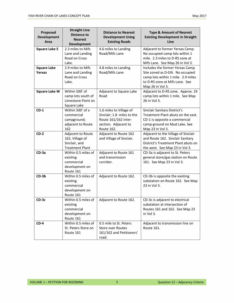
FISH RIVER CHAIN OF LAKES CONCEPT PLAN May 2017
5
VOLUME 1 – PETITION FOR REZONING Question 12 – Adjacency Criteria
Proposed Development
Area
Straight Line Distance to
Nearest Development
Distance to Nearest Development Using
Existing Roads
Type & Amount of Nearest Existing Development in Straight
Line
Square Lake E 2.3 miles to Mifs Lane and Landing Road on Cross Lake.
4.6 miles to Landing Road/Mifs Lane
Adjacent to former Yerxas Camp. No occupied camp lots within 1 mile. 2.3 miles to D-RS zone at Mifs Lane. See Map 26 in Vol 3.
Square Lake Yerxas
2.9 miles to Mifs Lane and Landing Road on Cross Lake.
4.8 miles to Landing Road/Mifs Lane
Includes the former Yerxas Camp. Site zoned as D-GN. No occupied camp lots within 1 mile. 2.9 miles to D-RS zone at Mifs Lane. See Map 26 in Vol 3.
Square Lake W Within 500’ of camp lots south of Limestone Point on Square Lake
Adjacent to Square Lake Road
Adjacent to D-RS zone. Approx. 19 camp lots within 1 mile. See Map 26 in Vol 3.
CD-1 Within 500’ of a commercial campground; adjacent to Route 162
1.6 miles to Village of Sinclair; 1.8 miles to the Route 161/162 inter-section. Adjacent to Route 162.
Sinclair Sanitary District’s Treatment Plant abuts on the east. CD-1 is opposite a commercial camp-ground on Mud Lake. See Map 23 in Vol 3.
CD-2 Adjacent to Route 162, Village of Sinclair, and Treatment Plant
Adjacent to Route 162 and Village of Sinclair.
Adjacent to the Village of Sinclair and Route 162. Sinclair Sanitary District’s Treatment Plant abuts on the west. See Map 23 in Vol 3.
CD-3a Within 0.5 miles of existing commercial development on Route 161
Adjacent to Route 161 and transmission corridor.
CD-3a is adjacent to St. Peters general store/gas station on Route 161. See Map 23 in Vol 3.
CD-3b Within 0.5 miles of existing commercial development on Route 161
Adjacent to Route 162. CD-3b is opposite the existing substation on Route 162. See Map 23 in Vol 3.
CD-3c Within 0.5 miles of existing commercial development on Route 161
Adjacent to Route 162. CD-3c is adjacent to electrical substation at intersection of Routes 161 and 162. See Map 23 in Vol 3.
CD-4 Within 0.5 miles of St. Peters Store on Route 161
0.5 mile to St. Peters Store over Routes 161/162 and Petitioners’ road.
Adjacent to transmission line on Route 161.
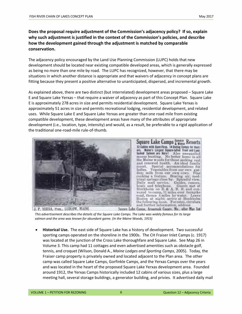
FISH RIVER CHAIN OF LAKES CONCEPT PLAN May 2017
6
VOLUME 1 – PETITION FOR REZONING Question 12 – Adjacency Criteria
Does the proposal require adjustment of the Commission’s adjacency policy? If so, explain why such adjustment is justified in the context of the Commission’s policies, and describe how the development gained through the adjustment is matched by comparable conservation.
The adjacency policy encouraged by the Land Use Planning Commission (LUPC) holds that new development should be located near existing compatible developed areas, which is generally expressed as being no more than one mile by road. The LUPC has recognized, however, that there may be situations in which another distance is appropriate and that waivers of adjacency in concept plans are fitting because they present a positive alternative to unanticipated, dispersed, and incremental growth. As explained above, there are two distinct (but interrelated) development areas proposed – Square Lake E and Square Lake Yerxas – that require a waiver of adjacency as part of this Concept Plan. Square Lake E is approximately 278 acres in size and permits residential development. Square Lake Yerxas is approximately 51 acres in size and permits recreational lodging, residential development, and related uses. While Square Lake E and Square Lake Yerxas are greater than one road mile from existing compatible development, these development areas have many of the attributes of appropriate development (i.e., location, type, intensity) and would, as a result, be preferable to a rigid application of the traditional one-road-mile rule-of-thumb.
• Historical Use. The east side of Square Lake has a history of development. Two successful sporting camps operated on the shoreline in the 1900s. The CH Fraiser Inlet Camps (c. 1917) was located at the junction of the Cross Lake thoroughfare and Square Lake. See Map 26 in Volume 3. This camp had 11 cottages and even advertised amenities such as obstacle golf, tennis, and croquet (Wilson, Donald A., Maine Lodges and Sporting Camps, 2005). Today, the Fraiser camp property is privately owned and located adjacent to the Plan area. The other camp was called Square Lake Camps, Gorfinkle Camps, and the Yerxas Camps over the years and was located in the heart of the proposed Square Lake Yerxas development area. Founded around 1912, the Yerxas Camps historically included 12 cabins of various sizes, plus a large meeting hall, several storage buildings, a generator building, and privies. It advertised daily mail
This advertisement describes the details of the Square Lake Camps. The Lake was widely famous for its large salmon and the area was known for abundant game. (In the Maine Woods, 1915)
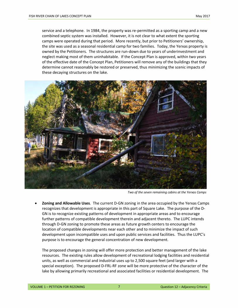
FISH RIVER CHAIN OF LAKES CONCEPT PLAN May 2017
7
VOLUME 1 – PETITION FOR REZONING Question 12 – Adjacency Criteria
service and a telephone. In 1984, the property was re-permitted as a sporting camp and a new combined septic system was installed. However, it is not clear to what extent the sporting camps were operated during that period. More recently, but prior to Petitioners’ ownership, the site was used as a seasonal residential camp for two families. Today, the Yerxas property is owned by the Petitioners. The structures are run-down due to years of underinvestment and neglect making most of them uninhabitable. If the Concept Plan is approved, within two years of the effective date of the Concept Plan, Petitioners will remove any of the buildings that they determine cannot reasonably be restored or preserved, thus minimizing the scenic impacts of these decaying structures on the lake.
• Zoning and Allowable Uses. The current D-GN zoning in the area occupied by the Yerxas Camps recognizes that development is appropriate in this part of Square Lake. The purpose of the D-GN is to recognize existing patterns of development in appropriate areas and to encourage further patterns of compatible development therein and adjacent thereto. The LUPC intends through D-GN zoning to promote these areas as future growth centers to encourage the location of compatible developments near each other and to minimize the impact of such development upon incompatible uses and upon public services and facilities. Thus the LUPC’s purpose is to encourage the general concentration of new development.
The proposed changes in zoning will offer more protection and better management of the lake resources. The existing rules allow development of recreational lodging facilities and residential units, as well as commercial and industrial uses up to 2,500 square feet (and larger with a special exception). The proposed D-FRL-RF zone will be more protective of the character of the lake by allowing primarily recreational and associated facilities or residential development. The
Two of the seven remaining cabins at the Yerxas Camps
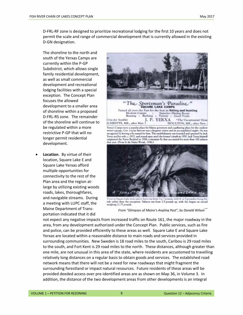
FISH RIVER CHAIN OF LAKES CONCEPT PLAN May 2017
8
VOLUME 1 – PETITION FOR REZONING Question 12 – Adjacency Criteria
D-FRL-RF zone is designed to prioritize recreational lodging for the first 10 years and does not permit the scale and range of commercial development that is currently allowed in the existing D-GN designation.
The shoreline to the north and south of the Yerxas Camps are currently within the P-GP Subdistrict, which allows single family residential development, as well as small commercial development and recreational lodging facilities with a special exception. The Concept Plan focuses the allowed development to a smaller area of shoreline within a proposed D-FRL-RS zone. The remainder of the shoreline will continue to be regulated within a more restrictive P-GP that will no longer permit residential development.
• Location. By virtue of their location, Square Lake E and Square Lake Yerxas afford multiple opportunities for connectivity to the rest of the Plan area and the region at-large by utilizing existing woods roads, lakes, thoroughfares, and navigable streams. During a meeting with LUPC staff, the Maine Department of Trans-portation indicated that it did not expect any negative impacts from increased traffic on Route 161, the major roadway in the area, from any development authorized under the Concept Plan. Public services, such as fire and police, can be provided efficiently to these areas as well. Square Lake E and Square Lake Yerxas are located within a reasonable distance to main roads and services provided in surrounding communities. New Sweden is 18 road miles to the south, Caribou is 29 road miles to the south, and Fort Kent is 29 road miles to the north. These distances, although greater than one mile, are not unusual in this area of the state, where residents are accustomed to travelling relatively long distances on a regular basis to obtain goods and services. The established road network means that there will not be a need for new roadways that might fragment the surrounding forestland or impact natural resources. Future residents of these areas will be provided deeded access over pre-identified areas are as shown on Map 36, in Volume 3. In addition, the distance of the two development areas from other developments is an integral
From “Glimpses of Maine’s Angling Past”, by Donald Wilson
FISH RIVER CHAIN OF LAKES CONCEPT PLAN May 2017
9
VOLUME 1 – PETITION FOR REZONING Question 12 – Adjacency Criteria
part of their appeal. These development areas are attractive precisely because they are not located too close to other developments.
• Recreational Hub. There is a unique opportunity for a central recreational facility in the region that will promote the “diverse and abundant recreational opportunities” and “sustainable economic opportunities” identified as crucial for the UT in Section 1.1 of the Comprehensive Land Use Plan. Square Lake Yerxas provides the opportunity to meet that need as a “Hub” in a “Hub, Spokes, and Rim” plan outlined in the response to Question 15, and is consistent with other, similar uses in the region. Map 32 in Volume 3 of the Petition Application shows existing recreational uses in the vicinity of the Plan area, as well as other existing sporting facilities in the region. Zoning for Square Lake Yerxas will allow development that is similar to and complementary of other uses in the area, such as the Eagle Lake Sporting Camp and the Fish River Lodge on Eagle Lake, the Lakeside Lodge in Sinclair, and the Long Lake Camps and Lodge in Sinclair. Complimentary zoning in Square Lake E will support development of Square Lake Yerxas as a recreational Hub, making development of a recreational lodging facility more likely to be sustainable.
• Appropriateness. Square Lake E and Square Lake Yerxas have a multitude of natural and
cultural features that are both unique to the Plan area and highly desirable for recreational and residential development, including a protected cove, a favorable western orientation, an established lakeside activity area, a natural beach, existing woods roads, interesting topography, highly varied vegetation, suitable soil conditions, and opportunities for deep water access. Yet, both development areas are large enough to allow development to avoid sensitive natural areas and provide flexibility for future development. The areas selected for Square Lake E and Square Lake Yerxas took into account deer wintering areas and smelt streams to the south, and possible rusty blackbird habitat to the north.
• Development Limits. The Concept Plan limits the intensity of development in both Square Lake E and Square Lake Yerxas by placing a cap on the number of new units and water access sites that can be developed. Under existing zoning, up to two dozen waterfront lots could be developed on Square Lake over the next 30 years, using the 2-in-5 approach (Square Lake is in two townships). This amount of unplanned development could change the inherent character of the lake, resulting in the degradation of its scenic character, fragmentation of the working forest, and inefficient road layout, while impacting areas of significant natural resource value. The Concept Plan limits the cumulative total of new development units on Square Lake to 130 over the 30-year life of the Concept Plan (including in Square Lake W), the vast majority of which would be set back from the water, thereby limiting their visibility and possible effect on the lake. Within this number, no more than 85 units could be developed in Square Lake E. For Square Lake Yerxas the development potential is capped at no more than 67 units; a recreational lodging facility is capped at 50 of those units. In addition, there can be no more than three water access sites to serve both Square Lake E and Square Lake Yerxas, only one of which can be a trailered ramp, which must provide public access to the lake.
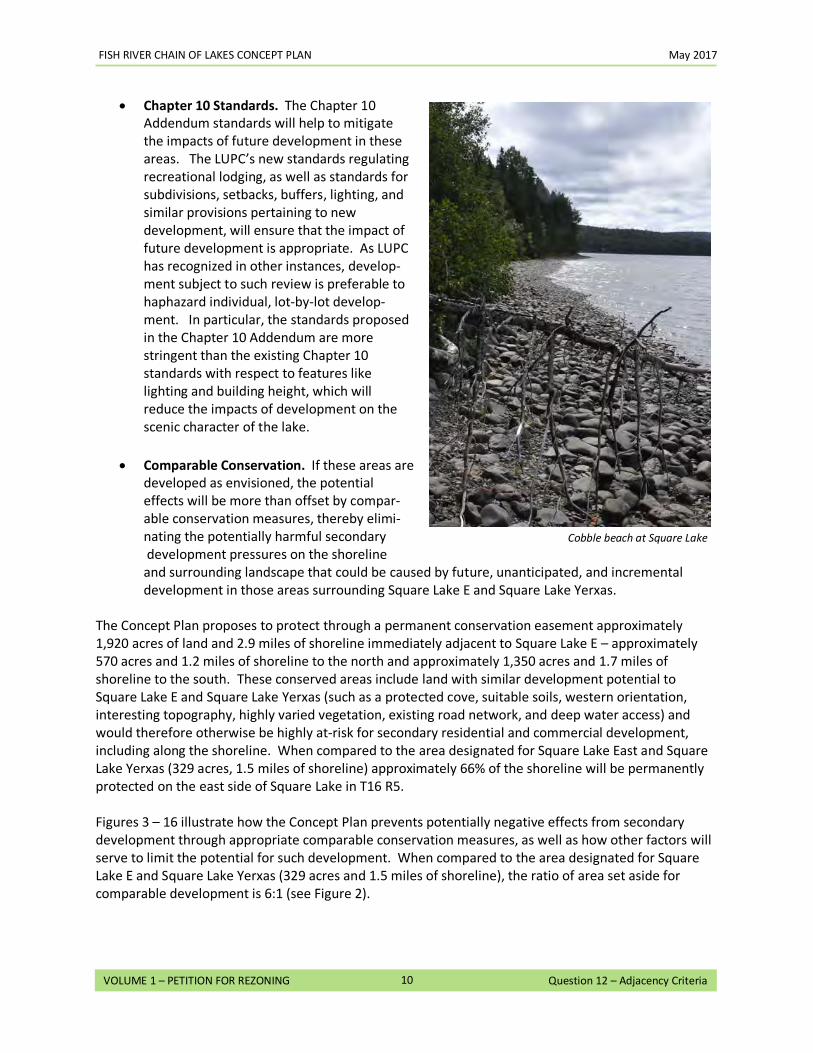
FISH RIVER CHAIN OF LAKES CONCEPT PLAN May 2017
10
VOLUME 1 – PETITION FOR REZONING Question 12 – Adjacency Criteria
• Chapter 10 Standards. The Chapter 10 Addendum standards will help to mitigate the impacts of future development in these areas. The LUPC’s new standards regulating recreational lodging, as well as standards for subdivisions, setbacks, buffers, lighting, and similar provisions pertaining to new development, will ensure that the impact of future development is appropriate. As LUPC has recognized in other instances, develop-ment subject to such review is preferable to haphazard individual, lot-by-lot develop-ment. In particular, the standards proposed in the Chapter 10 Addendum are more stringent than the existing Chapter 10 standards with respect to features like lighting and building height, which will reduce the impacts of development on the scenic character of the lake.
• Comparable Conservation. If these areas are
developed as envisioned, the potential effects will be more than offset by compar-able conservation measures, thereby elimi-nating the potentially harmful secondary development pressures on the shoreline and surrounding landscape that could be caused by future, unanticipated, and incremental development in those areas surrounding Square Lake E and Square Lake Yerxas.
The Concept Plan proposes to protect through a permanent conservation easement approximately 1,920 acres of land and 2.9 miles of shoreline immediately adjacent to Square Lake E – approximately 570 acres and 1.2 miles of shoreline to the north and approximately 1,350 acres and 1.7 miles of shoreline to the south. These conserved areas include land with similar development potential to Square Lake E and Square Lake Yerxas (such as a protected cove, suitable soils, western orientation, interesting topography, highly varied vegetation, existing road network, and deep water access) and would therefore otherwise be highly at-risk for secondary residential and commercial development, including along the shoreline. When compared to the area designated for Square Lake East and Square Lake Yerxas (329 acres, 1.5 miles of shoreline) approximately 66% of the shoreline will be permanently protected on the east side of Square Lake in T16 R5. Figures 3 – 16 illustrate how the Concept Plan prevents potentially negative effects from secondary development through appropriate comparable conservation measures, as well as how other factors will serve to limit the potential for such development. When compared to the area designated for Square Lake E and Square Lake Yerxas (329 acres and 1.5 miles of shoreline), the ratio of area set aside for comparable development is 6:1 (see Figure 2).
Cobble beach at Square Lake
FISH RIVER CHAIN OF LAKES CONCEPT PLAN May 2017
11
VOLUME 1 – PETITION FOR REZONING Question 12 – Adjacency Criteria
In addition, the areas included within the Conservation Easement will protect important habitats. These include deer wintering areas adjacent to approximately 4.5 miles of shoreline at the southern end of the lake, important fish habitat streams (Butler Brook and other smaller streams), wetland areas, eagle and osprey nesting sites, possible rusty blackbird habitat, and other resources that are important to the character and quality of Square Lake. Over 10.6 miles (76%) of the approximately 13.9 miles of shoreline that the Petitioners currently own on Square Lake will be permanently protected from development under the Conservation Easement. By comparison, with the approximately 1.8 miles (including Square Lake W) of potential new development area, there will be roughly six feet of permanent conservation for every foot of new development frontage on Square Lake, which is comparable with other concept plans approved by LUPC. In sum, a waiver of the adjacency principle’s usual one-road-mile rule-of-thumb for Square Lake E and Square Lake Yerxas is consistent with good planning principles and would serve the objectives of “appropriate” development from a locational, type and intensity perspective. A waiver would provide the opportunity to reestablish a traditional recreational lodging facility, supported by compatible and well-planned residential development that can be an essential element of an overall regional economic strategy (i.e., the Hub in the Hub, Spokes and Rim concept). In addition, the potential effects of development in this area (habitat and resource loss, visual quality, access, etc.) are either avoided through appropriate siting or mitigated through standards in the Chapter 10 Addendum. Finally, the potentially adverse consequences of secondary development that could come with development of Square Lake E and Square Lake Yerxas are effectively prevented through comparable conservation and practical development limitations in the surrounding area.
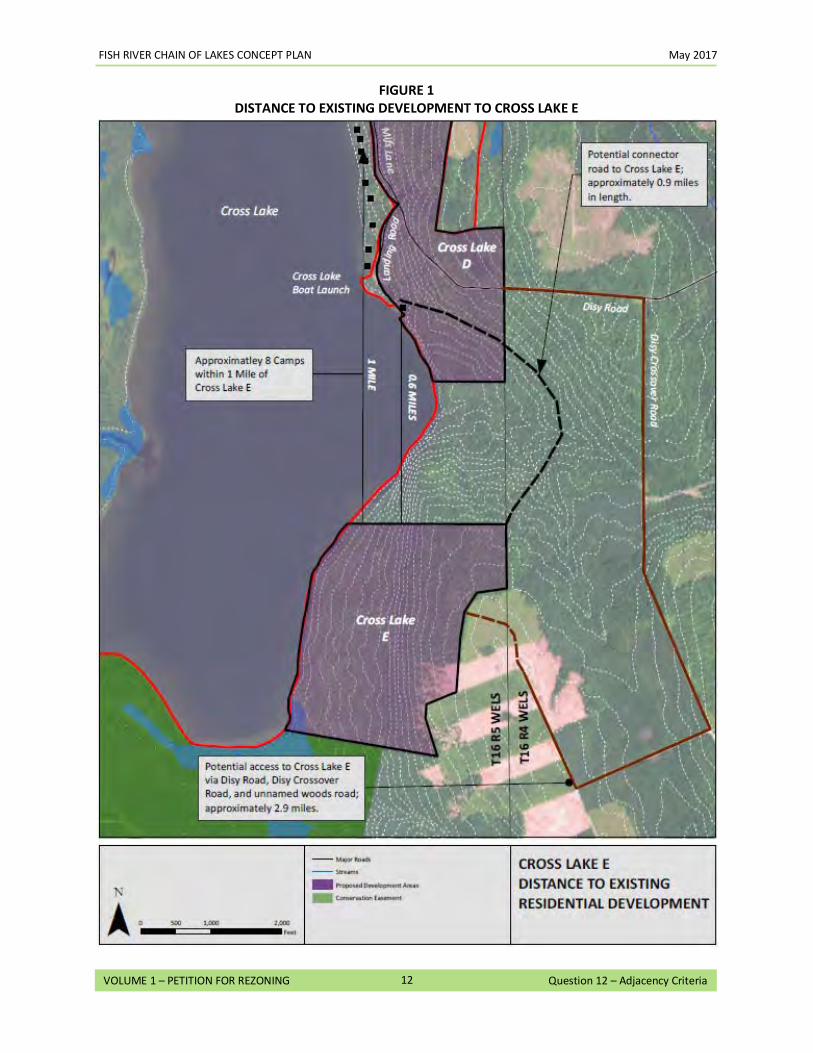
FISH RIVER CHAIN OF LAKES CONCEPT PLAN May 2017
12
VOLUME 1 – PETITION FOR REZONING Question 12 – Adjacency Criteria
FIGURE 1
DISTANCE TO EXISTING DEVELOPMENT TO CROSS LAKE E
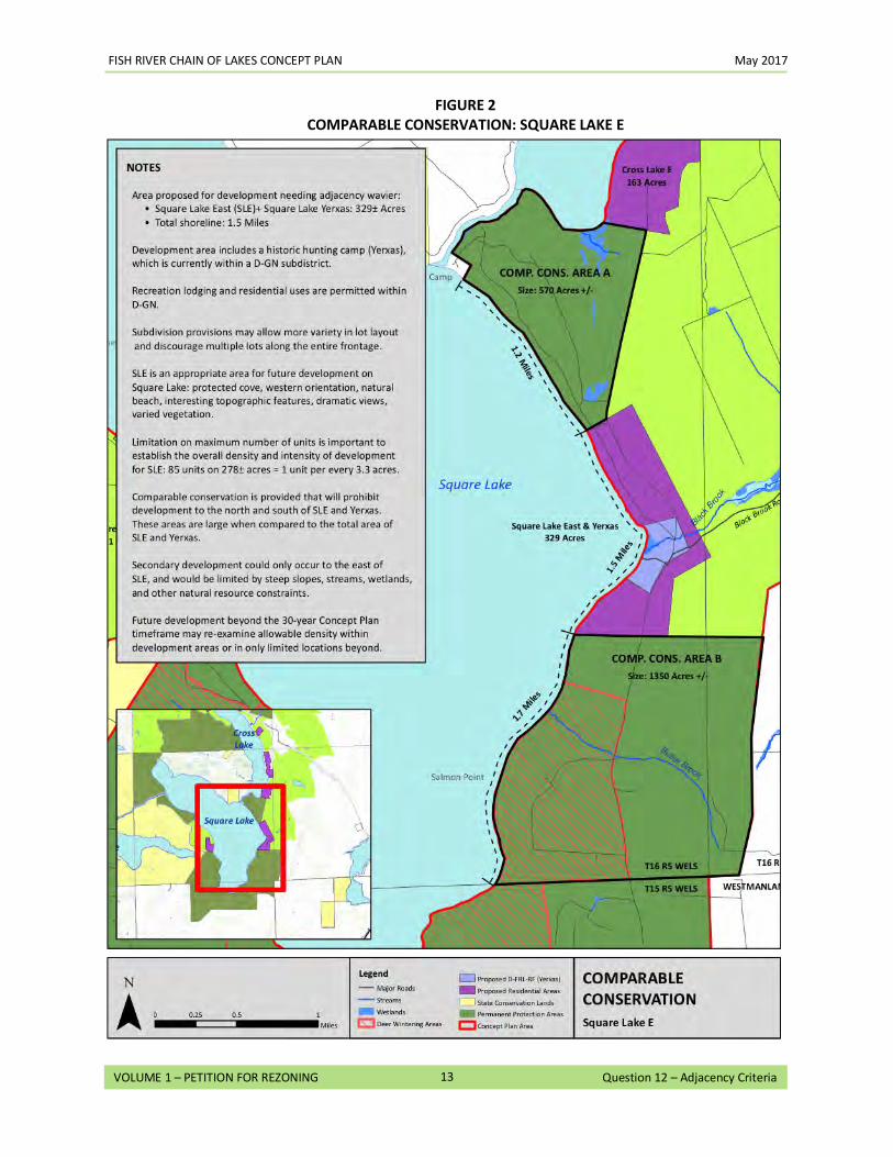
FISH RIVER CHAIN OF LAKES CONCEPT PLAN May 2017
13
VOLUME 1 – PETITION FOR REZONING Question 12 – Adjacency Criteria
FIGURE 2 COMPARABLE CONSERVATION: SQUARE LAKE E
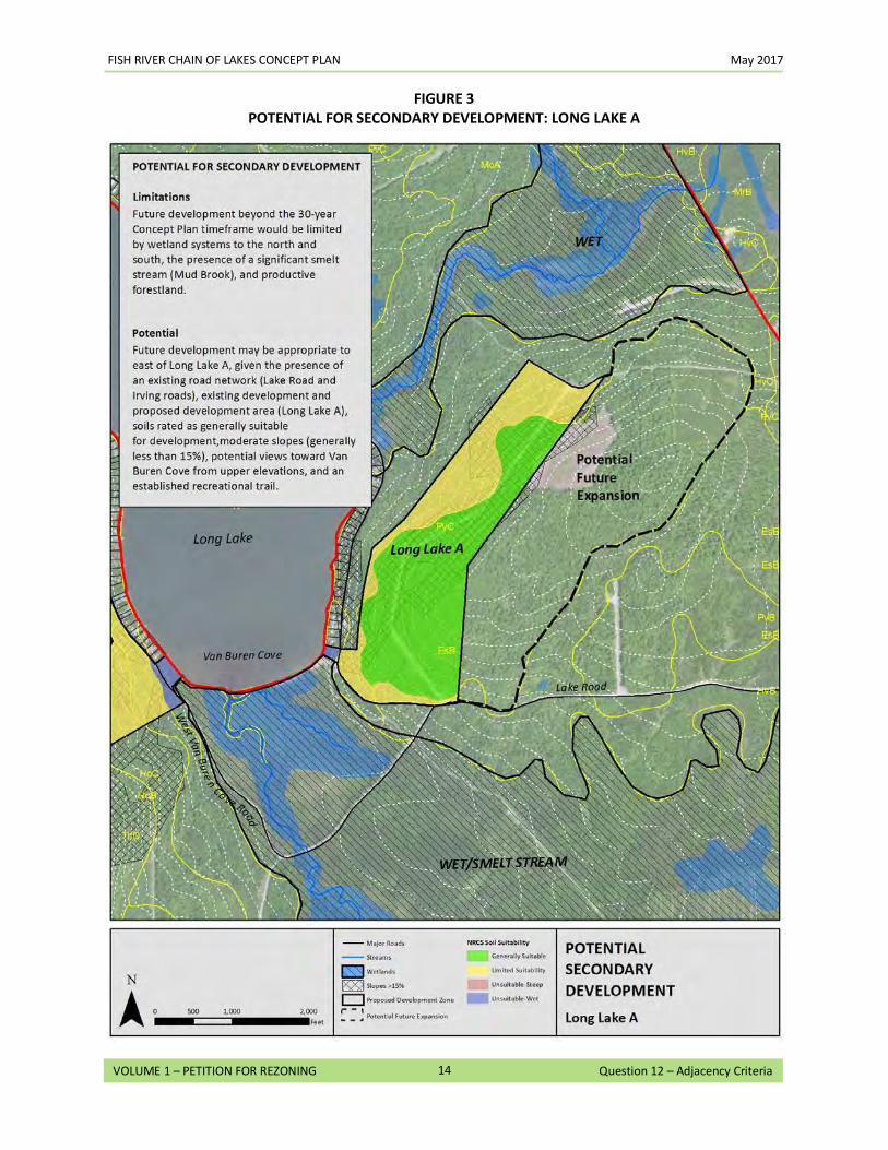
FISH RIVER CHAIN OF LAKES CONCEPT PLAN May 2017
14
VOLUME 1 – PETITION FOR REZONING Question 12 – Adjacency Criteria
FIGURE 3
POTENTIAL FOR SECONDARY DEVELOPMENT: LONG LAKE A
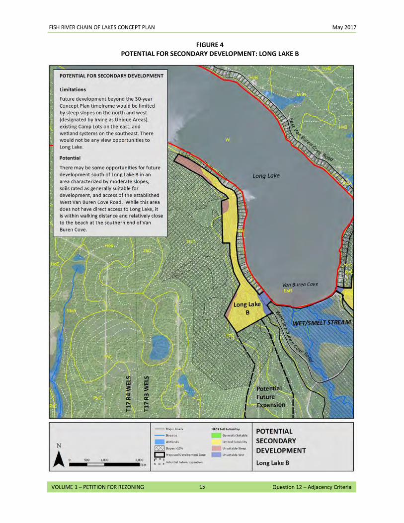
FISH RIVER CHAIN OF LAKES CONCEPT PLAN May 2017
15
VOLUME 1 – PETITION FOR REZONING Question 12 – Adjacency Criteria
FIGURE 4 POTENTIAL FOR SECONDARY DEVELOPMENT: LONG LAKE B
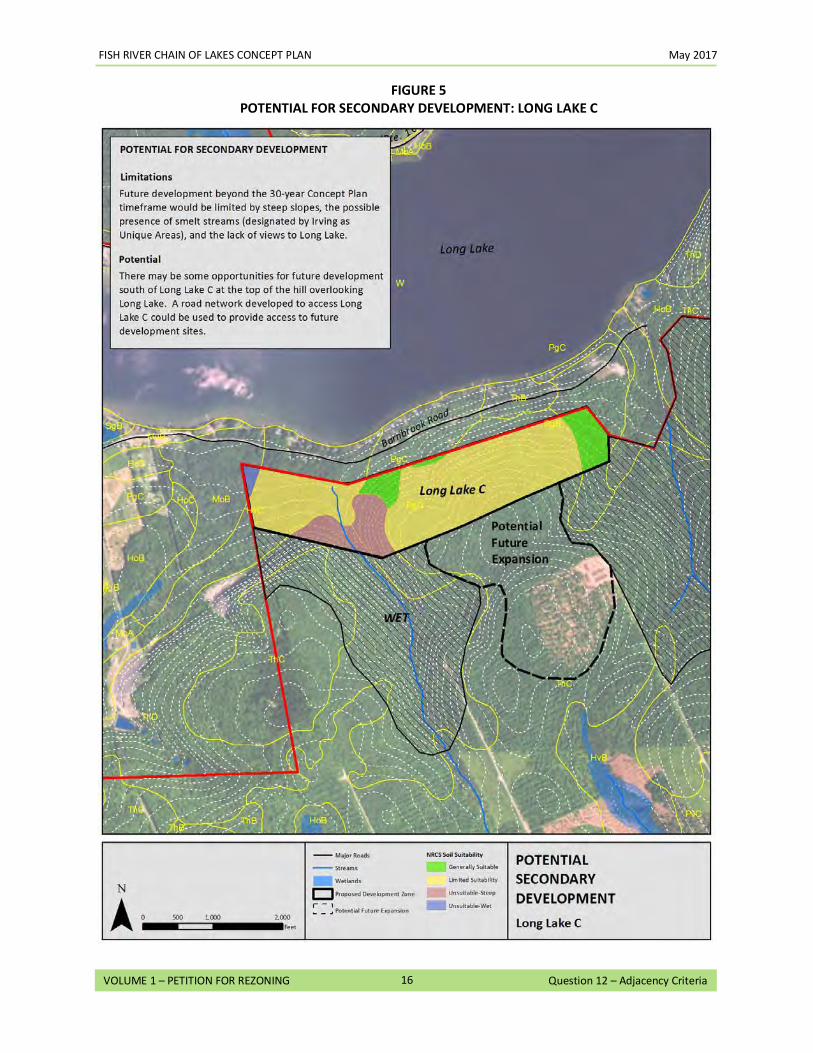
FISH RIVER CHAIN OF LAKES CONCEPT PLAN May 2017
16
VOLUME 1 – PETITION FOR REZONING Question 12 – Adjacency Criteria
FIGURE 5
POTENTIAL FOR SECONDARY DEVELOPMENT: LONG LAKE C
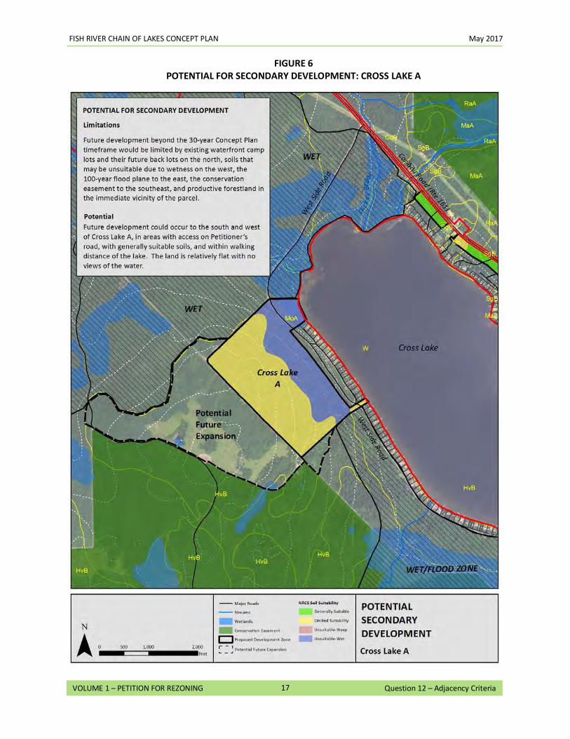
FISH RIVER CHAIN OF LAKES CONCEPT PLAN May 2017
17
VOLUME 1 – PETITION FOR REZONING Question 12 – Adjacency Criteria
FIGURE 6
POTENTIAL FOR SECONDARY DEVELOPMENT: CROSS LAKE A
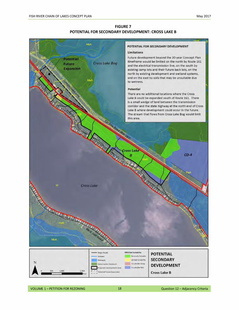
FISH RIVER CHAIN OF LAKES CONCEPT PLAN May 2017
18
VOLUME 1 – PETITION FOR REZONING Question 12 – Adjacency Criteria
FIGURE 7
POTENTIAL FOR SECONDARY DEVELOPMENT: CROSS LAKE B
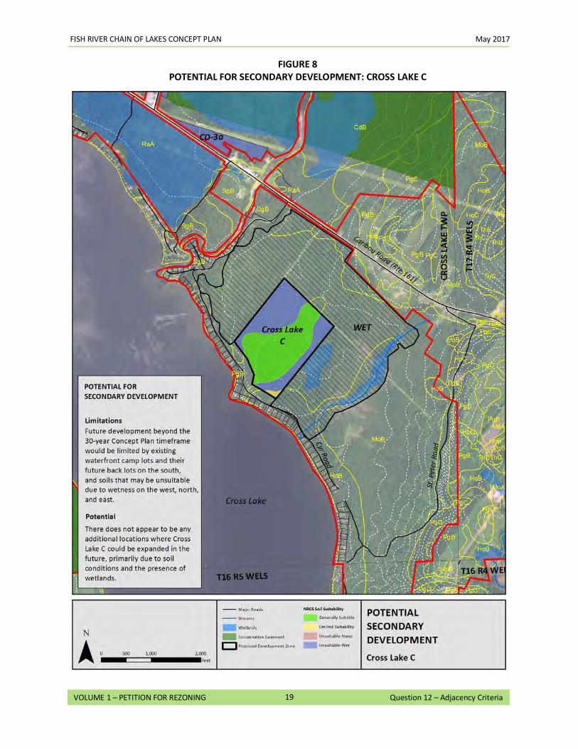
FISH RIVER CHAIN OF LAKES CONCEPT PLAN May 2017
19
VOLUME 1 – PETITION FOR REZONING Question 12 – Adjacency Criteria
FIGURE 8
POTENTIAL FOR SECONDARY DEVELOPMENT: CROSS LAKE C
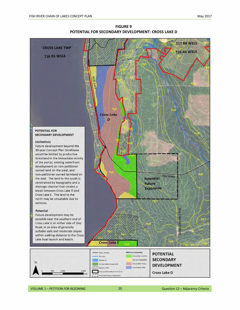
FISH RIVER CHAIN OF LAKES CONCEPT PLAN May 2017
20
VOLUME 1 – PETITION FOR REZONING Question 12 – Adjacency Criteria
FIGURE 9
POTENTIAL FOR SECONDARY DEVELOPMENT: CROSS LAKE D
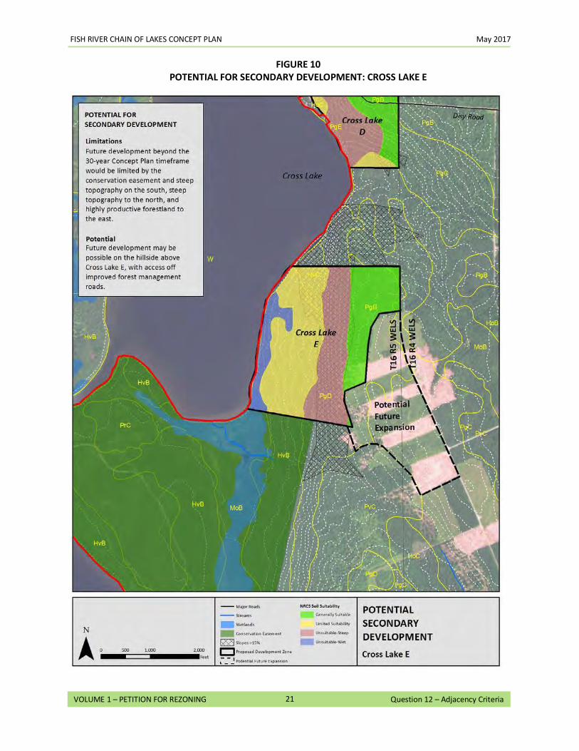
FISH RIVER CHAIN OF LAKES CONCEPT PLAN May 2017
21
VOLUME 1 – PETITION FOR REZONING Question 12 – Adjacency Criteria
FIGURE 10
POTENTIAL FOR SECONDARY DEVELOPMENT: CROSS LAKE E
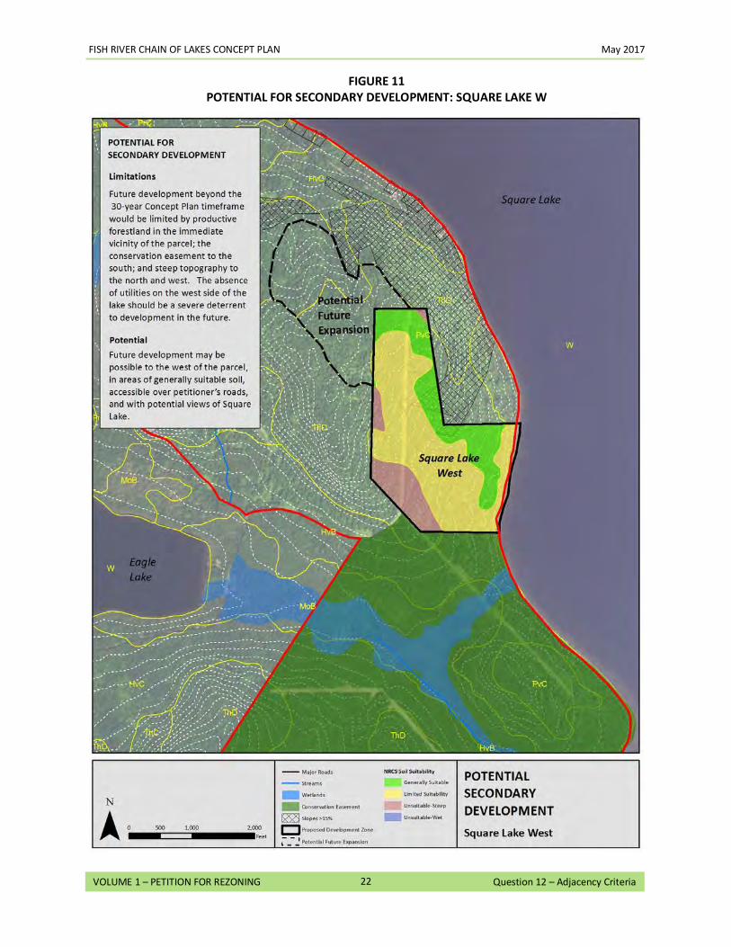
FISH RIVER CHAIN OF LAKES CONCEPT PLAN May 2017
22
VOLUME 1 – PETITION FOR REZONING Question 12 – Adjacency Criteria
FIGURE 11
POTENTIAL FOR SECONDARY DEVELOPMENT: SQUARE LAKE W
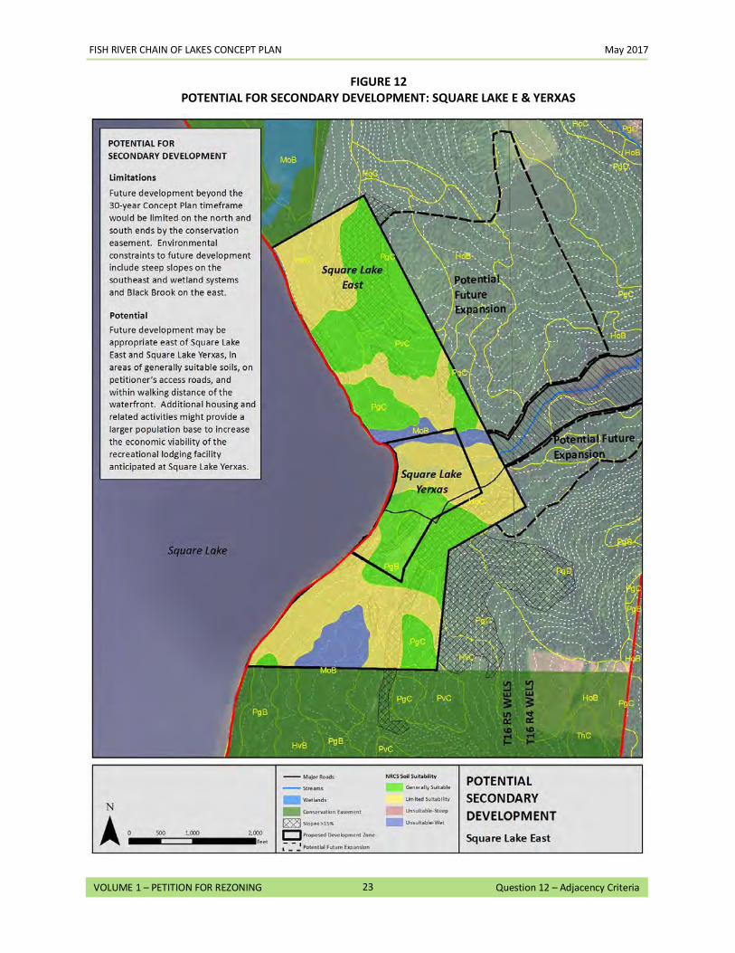
FISH RIVER CHAIN OF LAKES CONCEPT PLAN May 2017
23
VOLUME 1 – PETITION FOR REZONING Question 12 – Adjacency Criteria
FIGURE 12
POTENTIAL FOR SECONDARY DEVELOPMENT: SQUARE LAKE E & YERXAS
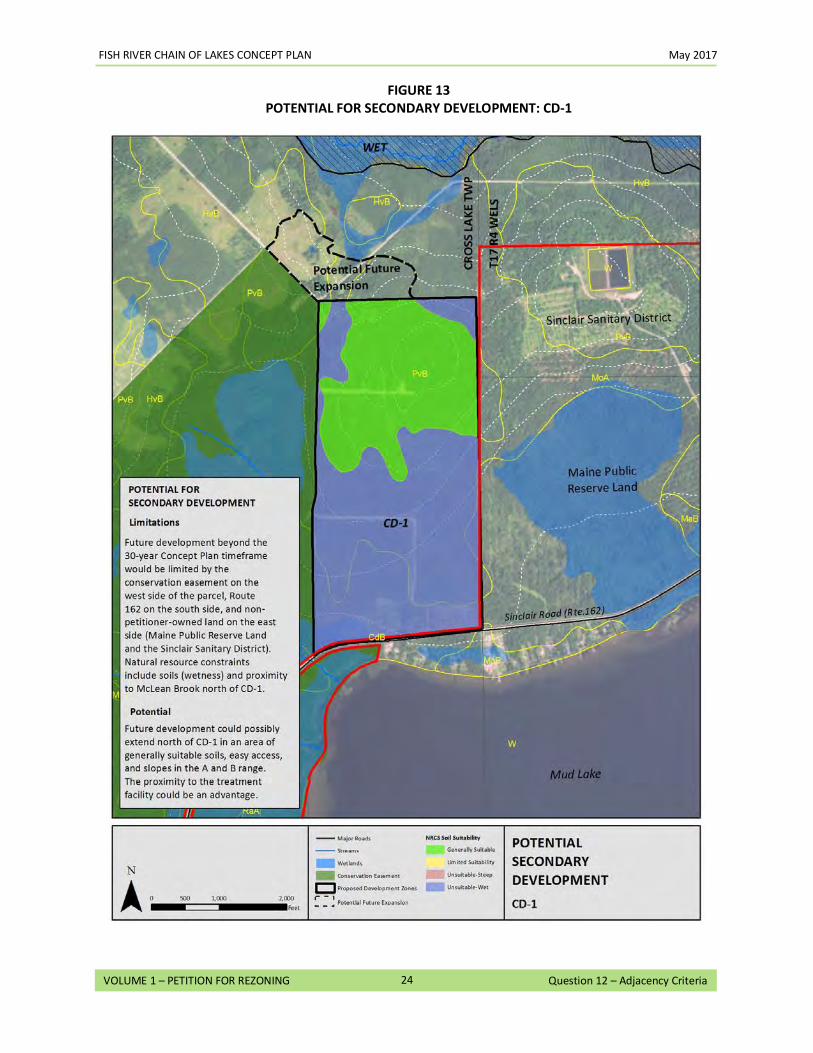
FISH RIVER CHAIN OF LAKES CONCEPT PLAN May 2017
24
VOLUME 1 – PETITION FOR REZONING Question 12 – Adjacency Criteria
FIGURE 13
POTENTIAL FOR SECONDARY DEVELOPMENT: CD-1
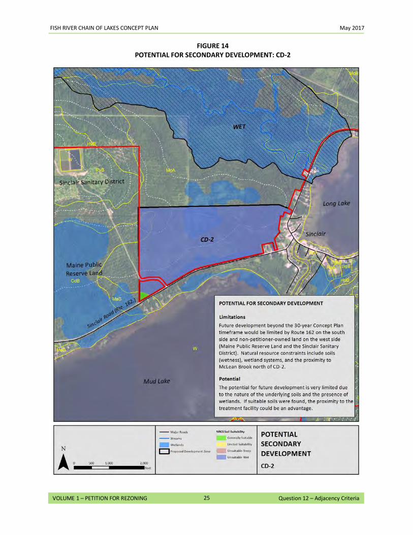
FISH RIVER CHAIN OF LAKES CONCEPT PLAN May 2017
25
VOLUME 1 – PETITION FOR REZONING Question 12 – Adjacency Criteria
FIGURE 14
POTENTIAL FOR SECONDARY DEVELOPMENT: CD-2
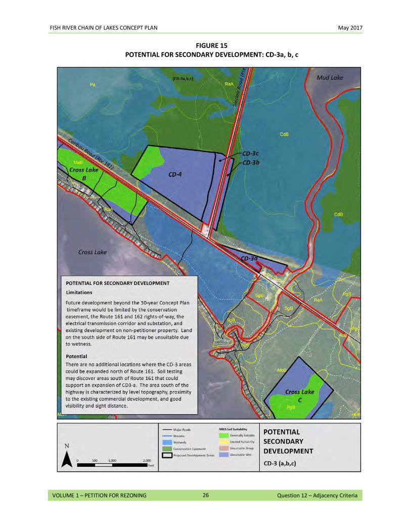
FISH RIVER CHAIN OF LAKES CONCEPT PLAN May 2017
26
VOLUME 1 – PETITION FOR REZONING Question 12 – Adjacency Criteria
FIGURE 15
POTENTIAL FOR SECONDARY DEVELOPMENT: CD-3a, b, c
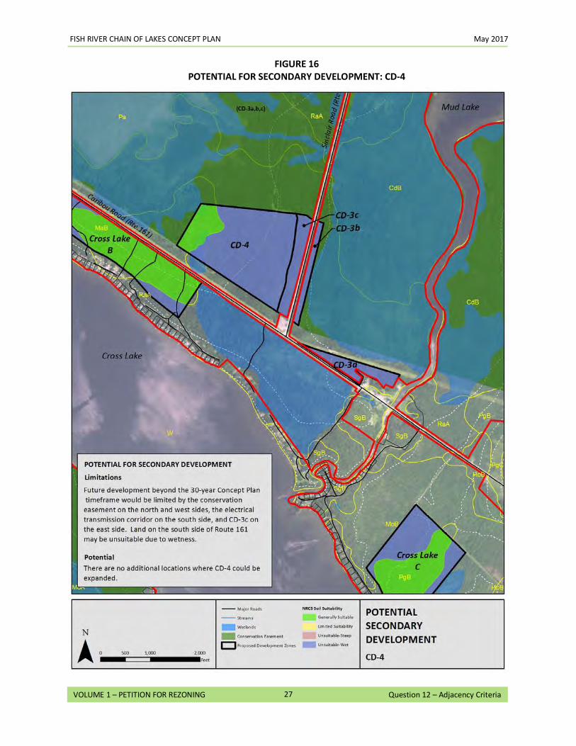
FISH RIVER CHAIN OF LAKES CONCEPT PLAN May 2017
27
VOLUME 1 – PETITION FOR REZONING Question 12 – Adjacency Criteria
FIGURE 16
POTENTIAL FOR SECONDARY DEVELOPMENT: CD-4
13. Protection Zoning: Is the P-RP zone that you propose more appropriate for the protection and management of existing uses and resources in the area? If so, describe how the P-RP zone is more appropriate.
As described in the responses to Questions 8 and 9, the land in and around the Plan area has a diverse range of existing uses and resources, including unfragmented working forest, interconnected water bodies, small ponds and streams, sensitive wildlife habitat, seasonal and year-round residences, recreational opportunities (such as boating, hunting, fishing, ATV riding and snowmobiling), and commercial development. These uses and resources are reflective of the principal values of the unorganized territory (UT), and, as with other areas in the UT, the Plan area has been subject to incremental and often haphazard development over time. This pattern can be observed in historical maps of the area (see Maps 11-13 in Volume 3), where shoreline development over time created linear lot configurations along several of the lakes within the Plan area. These lots are typically undersized when compared to current standards, concentrate development in the shoreland zone, and have no discernible common areas or neighborhood centers. Today, most of Petitioners’ holdings along the lakes are in D-RS, P-GP, or other subdistricts, which allows the creation of two lots per township every five years. Over the course of 30 years, Square Lake, for example (which is in two townships), could have two-dozen new houselots in various locations throughout the 13.9 miles of Petitioners’ shoreline. This incremental development approach could result in loss of public access, degradation of the scenic character of the area, fragmentation of the working forest, and inefficient road layouts, while impacting areas of significant natural resource value. Although an individual home or camp may not cause a noticeable change to a lake, the cumulative effect of continued unplanned development could be significant. The P-RP zoning being proposed under the Concept Plan is more appropriate for the protection and management of the existing uses and resources in the area for the following reasons:
• The Concept Plan is more appropriate for the protection and management of the existing forest resources and commercial forest uses. Incremental growth within the Plan area could threaten the viability of the working forest and create unanticipated conflicts between commercial forest uses and future development. The Concept Plan will protect the existing forest resources and commercial forest activities throughout the Plan area by locating development in areas that avoid fragmentation of working forestland and restricting the type and amount of development that can occur. The Concept Plan specifies access to future development areas over existing roads that are separate from main commercial haul roads to reduce potential use conflicts. Approximately 96% of the Plan area will be regulated by restrictive M-FRL-GN zoning that allows working forest operations, limits the type of commercial activities that can occur there, and prohibits residential development. All forest management activities will be subject to sustainable forestry practices, including outcome-based forestry, and long term management plans that are based on ecologically sound, economically appropriate, and socially responsible outcomes. Approximately 14,600 acres of the Plan area will also be subject to the Conservation Easement, which protects this area as a working forest in perpetuity.
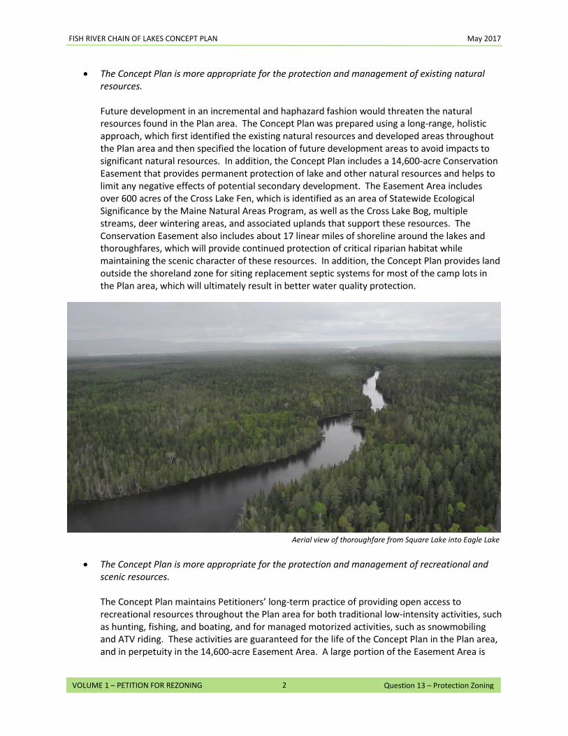
FISH RIVER CHAIN OF LAKES CONCEPT PLAN May 2017
2
VOLUME 1 – PETITION FOR REZONING Question 13 – Protection Zoning
• The Concept Plan is more appropriate for the protection and management of existing natural resources. Future development in an incremental and haphazard fashion would threaten the natural resources found in the Plan area. The Concept Plan was prepared using a long-range, holistic approach, which first identified the existing natural resources and developed areas throughout the Plan area and then specified the location of future development areas to avoid impacts to significant natural resources. In addition, the Concept Plan includes a 14,600-acre Conservation Easement that provides permanent protection of lake and other natural resources and helps to limit any negative effects of potential secondary development. The Easement Area includes over 600 acres of the Cross Lake Fen, which is identified as an area of Statewide Ecological Significance by the Maine Natural Areas Program, as well as the Cross Lake Bog, multiple streams, deer wintering areas, and associated uplands that support these resources. The Conservation Easement also includes about 17 linear miles of shoreline around the lakes and thoroughfares, which will provide continued protection of critical riparian habitat while maintaining the scenic character of these resources. In addition, the Concept Plan provides land outside the shoreland zone for siting replacement septic systems for most of the camp lots in the Plan area, which will ultimately result in better water quality protection.
• The Concept Plan is more appropriate for the protection and management of recreational and scenic resources. The Concept Plan maintains Petitioners’ long-term practice of providing open access to recreational resources throughout the Plan area for both traditional low-intensity activities, such as hunting, fishing, and boating, and for managed motorized activities, such as snowmobiling and ATV riding. These activities are guaranteed for the life of the Concept Plan in the Plan area, and in perpetuity in the 14,600-acre Easement Area. A large portion of the Easement Area is
Aerial view of thoroughfare from Square Lake into Eagle Lake
FISH RIVER CHAIN OF LAKES CONCEPT PLAN May 2017
3
VOLUME 1 – PETITION FOR REZONING Question 13 – Protection Zoning
adjacent to the State’s 24,084-acre Eagle Lake Unit, managed by the Bureau of Parks and Lands. The Eagle Lake Unit has 25 miles of shared use roads, which are managed for general snowmobile and ATV use. When joined together, the Eagle Lake Unit and the Easement Area represent over 60 square miles of permanently protected habitat, forestland, and waterbodies that can be enjoyed by the public for a variety of recreational activities.
The Concept Plan provides that the Van Buren Cove beach on Long Lake will remain a public access point and that the Cross Lake boat launch, picnic area, and beach will become a public facility. Further, Petitioners will seek approvals to construct a hand carry boat launch on the western end of Mud Lake, thereby providing the only direct public access to that waterbody. Also, a portion of the shorefront on the east side of Square Lake (see Map 34 in Volume 3) will be zoned to allow for a water access facility. Any recreational lodging facility at Square Lake Yerxas will be required to develop a publicly available trailered ramp (unless one already exists by then in either Square Lake E or Square Lake Yerxas). This will help support equitable access to Square Lake, which is currently inadequate. In addition, the Concept Plan identifies locations for future remote campsites and remote rental cabins in the more remote parts of the Plan area. The locations for these recreational resources have been planned as part of the Hub, Spokes and Rim concept to enhance recreational opportunities overall. The Concept Plan has been developed to minimize impacts to the scenic resources found throughout the Plan area. Development directly on the shoreline is very limited, and where it is allowed it will be subject to the Chapter 10 Addendum provisions for waterfront development. The residential development areas avoid ridgeline development that would be highly visible from the lakes. The majority of the proposed residential development areas are set back from the water and will be able to take advantage of existing roadways, thus minimizing visual impacts.
• The Concept Plan is designed to complement and supplement existing uses and development
patterns.
The proposed development areas, including Square Lake Yerxas, are consistent with existing uses throughout the Plan area and adjacent communities. The proposed CD-2 development area, for example, is located next to the Village of Sinclair and is being zoned to permit comparable uses (the D-FRL-GN zone is similar to the existing D-GN Subdistrict), and to take advantage of existing public services. The other CD areas are similar in that they will complement adjacent existing development and supplement more regional growth opportunities. Most of the residential development areas are sited near or adjacent to existing development of similar scale, and will provide a logical extension to these existing patterns while minimizing the potential for more dispersed growth. Further, the zoning of Square Lake Yerxas and Square Lake E, which will permit development of a recreational lodging facility and residential development, allows the continuation of the historic and existing uses allowed on Square Lake while protecting the majority of the shoreline from development. In addition, the recreational lodging development allowed at Square Lake Yerxas will help support the recreational uses of the area and act as a hub for recreational activity, thereby supporting other development opportunities within the Plan area and the region.
14. Shoreland Criteria: The Commission’s lake management program contains policy statements that include review criteria for permit applications (including petitions for rezoning prior to such activities) that could affect the shoreline. These special review criteria for intensive development proposed on lakes are included in the Commission’s Land Use Districts and Standards under provisions of Section 10.13,B,2. If your petition for rezoning includes any shoreland areas, carefully read and refer to the Review Criteria for Shoreland Permits in Appendix C of the Comprehensive Land Use Plan (pages C-6 and C-7) and the Review Standards for Structures Adjacent to Lakes in Section 10.13,B,2 of the Commission’s Land Use Districts and Standards. Explain how the proposed rezoning is consistent with the following criteria.
The Plan area includes approximately 34.5 miles of shoreline between the lakes (Long Lake, Mud Lake, Cross Lake, Square Lake), ponds (Carry Pond, Dickey Pond, and Little California Pond), and thoroughfares. No specific developments are being proposed as part of the Concept Plan, aside from a small hand carry boat launch on the western end of Mud Lake. The proposed zoning in certain areas around Long Lake, Cross Lake, and Square Lake will allow for future development opportunities. Within the shoreland areas of the smaller ponds (Carry Pond, Dickey Pond, and Little California Pond), development is highly restricted through the Chapter 10 Addendum, with the exception of one remote campsite or remote rental cabin on or near the shoreline of each pond.
The following is a discussion of how the Concept Plan meets the review criteria for Shoreland permits in Appendix C of the Comprehensive Land Use Plan (CLUP) (pages C-6 and C-7) and the Review Standards for Structures Adjacent to Lakes in Section 10.25,A of Chapter 10.
a. Natural and Cultural Resource Values: The proposal will not adversely affect natural and cultural
resource values.
The Maine Wildland Lakes Assessment assigns the following natural and cultural resource values for the lakes and ponds within the Plan area.1
1 To gauge the significance of the natural and cultural resource values in the Plan area, the Maine Wildland Lakes Assessment (commonly referred to as the Lakes Assessment) assigns the following resource categories to the lakes within the Plan area and rates them as either “significant” (meaning they met a predetermined minimum standard of significance) or “outstanding” (meaning they are clearly of statewide importance due to unique or otherwise noteworthy characteristics).
• Botanical Resources - To be considered for its botanical resources, the lake had to have at least one significant botanic feature within the 250-foot shoreland zone. Qualifying resources include rare, threatened, or endangered, plants; natural old growth forest stands; or peatlands or other unique freshwater wetlands.
• Cultural/Historic Resources - Qualifying cultural resources are classified into four general groups: 1)
prehistoric archaeological features; 2) historic archaeological features; 3) historic structures; and 4) other lake-related historical features. Cultural resources within the 250-foot shoreland zone were included in the assessment; cultural resources outside the shoreland zone were considered if they had a direction connection to the lake.
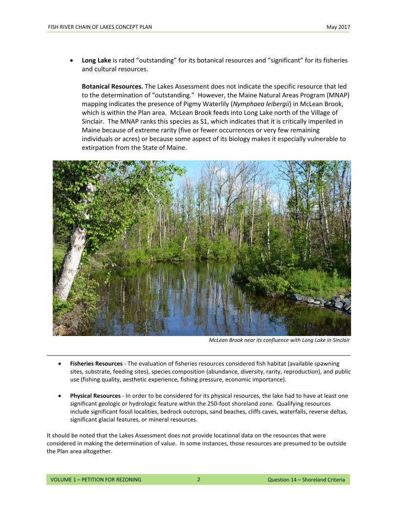
FISH RIVER CHAIN OF LAKES CONCEPT PLAN May 2017
2
VOLUME 1 – PETITION FOR REZONING Question 14 – Shoreland Criteria
• Long Lake is rated “outstanding” for its botanical resources and “significant” for its fisheries
and cultural resources. Botanical Resources. The Lakes Assessment does not indicate the specific resource that led to the determination of “outstanding.” However, the Maine Natural Areas Program (MNAP) mapping indicates the presence of Pigmy Waterlily (Nymphaea leibergii) in McLean Brook, which is within the Plan area. McLean Brook feeds into Long Lake north of the Village of Sinclair. The MNAP ranks this species as S1, which indicates that it is critically imperiled in Maine because of extreme rarity (five or fewer occurrences or very few remaining individuals or acres) or because some aspect of its biology makes it especially vulnerable to extirpation from the State of Maine.
• Fisheries Resources - The evaluation of fisheries resources considered fish habitat (available spawning
sites, substrate, feeding sites), species composition (abundance, diversity, rarity, reproduction), and public use (fishing quality, aesthetic experience, fishing pressure, economic importance).
• Physical Resources - In order to be considered for its physical resources, the lake had to have at least one significant geologic or hydrologic feature within the 250-foot shoreland zone. Qualifying resources include significant fossil localities, bedrock outcrops, sand beaches, cliffs caves, waterfalls, reverse deltas, significant glacial features, or mineral resources.
It should be noted that the Lakes Assessment does not provide locational data on the resources that were considered in making the determination of value. In some instances, those resources are presumed to be outside the Plan area altogether.
McLean Brook near its confluence with Long Lake in Sinclair ll
FISH RIVER CHAIN OF LAKES CONCEPT PLAN May 2017
3
VOLUME 1 – PETITION FOR REZONING Question 14 – Shoreland Criteria
Nothing proposed in the Concept Plan should have any effect on this species. The closest development area, CD-2, is at its closest point approximately 0.25 miles south of McLean Brook and the stream itself is protected by P-WL3, P-FW and other protection zones. Additionally, the majority of the runoff from this area flows south toward Mud Lake, away from McLean Brook. Fisheries Resources. The Maine Department of Inland Fisheries and Wildlife (IF&W) considers Long Lake to be the top salmon producing water in Northern Maine. The lake is a destination for anglers throughout New England seeking trophy-size salmon. The quality of the fisheries is a result of several factors: high oxygen levels in the deepest parts of the lake; abundant farmland within the watershed with highly productive limestone soils; and over a dozen streams feeding into the lake that serve as spawning habitat for smelt, salmon’s main forage fish. Nothing proposed in the Concept Plan should have a negative effect on the quality of the fisheries in Long Lake. The majority of the land that will be rezoned for development is in close proximity to existing development and is well upland from the lake itself. Future development within Long Lake A, B, and C will be subject to the Chapter 10 Addendum rules for subdivisions, surface water quality, phosphorus control, and – where applicable – setbacks, height restrictions, and buffering for structures adjacent to lakes. Cultural Resources. The Maine Historic Preservation Commission (MHPC) has not identified any known prehistoric sites, archaeological sites, or architectural resources within the shoreland zone surrounding Long Lake. However, due to the nature of the State’s inventory of Cultural Resources and the characteristics of the Plan area, additional information will likely be required as part of any future development projects. This would include a Phase I archeological survey within the specific project area and an architectural assessment to determine if any structures would be eligible for inclusion on the National Register of Historic Places.
• Mud Lake is rated “significant” for its fisheries and cultural resources. Fisheries Resources. Mud Lake is listed as the #1 priority lake in the Strategic Plan for Providing Public Access to Maine Waters for Boating and Fishing, 1995 and 2000.2 Nothing proposed in the Concept Plan should have a negative effect on the quality of the fisheries in Mud Lake, particularly given the Petitioners’ decision in response to feedback from environmental groups to remove a residential development area proposed for Mud Lake in an initial draft of the Concept Plan. The Concept Plan proposes to construct a hand carry launch to provide public access to the lake which would also enable Maine IF&W to better monitor the fishery resource and stock the lake. Cultural Resources. The MHPC has not identified any known prehistoric or historic archaeological sites or architectural resources within the shoreland zone surrounding Mud
2 Strategic Plan for Providing Public Access to Maine Waters for Boating and Fishing, 1995 and 2000. Boating Facilities Program of the Maine Dept. of Agriculture, Conservation, & Forestry, Maine Department of Inland Fisheries and Wildlife.
FISH RIVER CHAIN OF LAKES CONCEPT PLAN May 2017
4
VOLUME 1 – PETITION FOR REZONING Question 14 – Shoreland Criteria
Lake. Due to the nature of the State’s inventory of Cultural Resources and the characteristics of the Plan area additional information will likely be required as part of any future development projects, such as for the proposed hand carry launch. There are no development areas proposed on Mud Lake (other than the hand carry launch) and approximately 1.7 miles of shoreline are included in the Conservation Easement.
• Cross Lake is rated “outstanding” for its botanical resources and “significant” for its fisheries and cultural resources. Botanical Resources. There are two botanical resources that are associated with Cross Lake: the Cross Lake Fen, a 1,500 acre wetland on the west side of the lake that is listed as a Beginning with Habitat Focus Area of Statewide Significance; and the Cross Lake Bog, an approximately 3,000-acre inland waterfowl and wading bird habitat that runs from Dickey Brook on the west to the Cross Lake thoroughfare on the east. See Maps 19 and 20 in Volume 3. Nothing proposed in the Concept Plan should have a negative effect on the botanical resources for Cross Lake. Much of the land that will be rezoned for development is in close proximity to existing development and upland from the lake itself. Future development will be subject to the Chapter 10 Addendum rules for subdivisions, surface water quality, phosphorus control, and – where applicable – setbacks, height restrictions, and buffering for structures adjacent to lakes. In addition, the Conservation Easement will protect the entirety of the Cross Lake Fen on Petitioner’s property (over 600 acres) and all of the Cross Lake Bog. Fisheries Resources. Maine IF&W considers Cross Lake to be one of the most popular lakes for fishing in the Fish River watershed (along with Long Lake and Square Lake). Cross Lake supports a sport fishery of statewide significance for brook trout and landlocked salmon. Nothing proposed in the Concept Plan should have a negative effect on the quality of the fisheries in Cross Lake. Of the five development areas zoned for residential development around Cross Lake, there are only two that have shore frontage (approximately 0.8 miles in the aggregate.) The majority of the land that will be rezoned for residential development around Cross Lake is upland from the lake. Future development on the lake will be subject to the Chapter 10 Addendum rules for rules for subdivisions, surface water quality, phosphorus control, and – where applicable – for structures adjacent to lakes. The Conservation Easement will preserve over two miles of shoreline on the west side of the lake. The Concept Plan requires that the existing Cross Lake Boat Launch and picnic area becomes a public access point, while at the same time limiting additional water access sites for new development. Cultural Resources. MHPC identified three known prehistoric archaeological sites: one on the east side of the lake at or near point where the Mud Lake / Cross Lake thoroughfare discharges into Cross Lake, and two along the thoroughfare into Square Lake at the southern end of the lake. No survey work has been conducted within the Plan area, according to the MHPC.
FISH RIVER CHAIN OF LAKES CONCEPT PLAN May 2017
5
VOLUME 1 – PETITION FOR REZONING Question 14 – Shoreland Criteria
Nothing proposed in the Concept Plan should have a negative effect on the cultural resources for Cross Lake. The area on the east side of the lake surrounding the Mud Lake thoroughfare is largely developed with existing camp lots and will not be affected by any of the proposed residential development areas. The area on the north side of the thoroughfare into Square Lake is not owned by the Petitioner and is not part of the Plan area. The area on the south side of the thoroughfare into Square Lake is part of the Conservation Easement land that extends from Cross Lake to Square Lake. The Concept Plan allows for one remote campsite on Petitioners’ land at the beginning of the thoroughfare into Square Lake. MHPC has no historic archaeological maps of Cross Lake. Due to the nature of the State’s inventory of Cultural Resources and the characteristics of the Plan area additional information will likely be required as part of any future development projects. This could include a Phase I archeological survey within the specific development area and an architectural assessment to determine if any structures would be eligible for inclusion on the National Register of Historic Places.
• Square Lake is rated “outstanding” for its fisheries resources and “significant” for its cultural and physical resources. Fisheries Resources. Maine IF&W considers Square Lake to be one of the most popular lakes in the Fish River watershed for fishing. Square Lake supports a sport fishery of statewide significance for brook trout and landlocked salmon. IF&W considers Square Lake to be underutilized from a fisheries perspective and would like to see more people fishing on it. Square Lake is listed as the #2 priority lake in the Strategic Plan for Providing Public Access to Maine Waters for Boating and Fishing, 1995 and 2000.3 Nothing proposed in the Concept Plan should have a negative effect on the quality of the fisheries in Square Lake. The majority of the land that will be rezoned under the Concept Plan is upland from the lake. Future development on the lake will be subject to the Chapter 10 Addendum rules for subdivisions, surface water quality, phosphorus control, and – where applicable – for structures adjacent to lakes. The Conservation Easement will preserve approximately 10.6 miles of shoreline and provide permanent protection for several significant smelt streams at the southern end of the lake. Water access for new development is limited and there are provisions in Square Lake Yerxas and Square Lake E for a new public access point on the east side of the lake to meet the need identified by Maine IF&W. Cultural Resources. MHPC identified one known prehistoric archaeological site near the Cross Lake / Square Lake thoroughfare. Nothing proposed in the Concept Plan should have a negative effect on the cultural resources for Square Lake. Due to the nature of the State’s inventory of Cultural Resources and the characteristics of the Plan area, additional information will likely be required as part of any future development projects. This would include a Phase I archeological survey
3 Strategic Plan for Providing Public Access to Maine Waters for Boating and Fishing, 1995 and 2000. Boating Facilities Program of the Maine Dept. of Agriculture, Conservation, & Forestry, Maine Department of Inland Fisheries and Wildlife.
FISH RIVER CHAIN OF LAKES CONCEPT PLAN May 2017
6
VOLUME 1 – PETITION FOR REZONING Question 14 – Shoreland Criteria
within the specific development area and an architectural assessment to determine if any structures would be eligible for inclusion on the National Register of Historic Places. In addition, the area surrounding the identified prehistoric archaeological site is either within the state-owned Eagle Lake Public Reserve Land or is within the Conservation Easement. The Concept Plan also allows for two remote campsites on Petitioners’ land at the beginning of the thoroughfare into Eagle Lake. However, these sites are limited in size and are will be for recreational use. Physical Resources. Irving’s Unique Areas Program identifies a unique physical resource – Limestone Point – on the west side of Square Lake. This site is a locally popular area for fossil hunting, picnicking, and camping. Nothing proposed in the Concept Plan should have a negative effect on the physical resources for Square Lake. Limestone Point is included in the Conservation Easement as part of the approximately 10.6 miles of Square Lake shoreline that will be preserved. The Concept Plan includes a picnic area and campsite at the point, which will be a continuation of the traditional uses for the site.
• Carry Pond, Dickey Pond and Little California Pond are not included in the Lake Assessment. Nonetheless, to protect their lake resources, the zoning has been amended to prohibit residential development around these smaller bodies of water and to promote recreation by permitting the development of a limited number of remote rental cabins and remote campsites as part of the Hub, Spokes and Rim system discussed in detail in the response to Question 15. Only one remote rental cabin or remote campsite is allowed on each of these ponds and the size is limited to ensure preservation of an appropriately remote recreation experience.
Despite the limited impact on the natural and cultural resources identified in the Lakes Assessment, the Concept Plan still takes the Lakes Assessment ratings into account and uses various mechanisms to assure that future shoreline development does not adversely affect the resource values identified as significant or outstanding in the Lakes Assessment. These mechanisms include:
• Dimensional standards requiring lots to have appropriate shore frontage, lot coverage
limitations, structural height restrictions, and appropriate setbacks from waterbodies and wetlands. See Section 10.26 in the Chapter 10 Addendum.
• Activity specific limitations for vegetation clearing within 250 feet of waterbodies, buffer strips, and water access sites. See Section 10.27 in the Chapter 10 Addendum.
• Development standards for erosion control, phosphorus, impacts to scenic character, and
lighting. See Section 10.25 in the Chapter 10 Addendum.
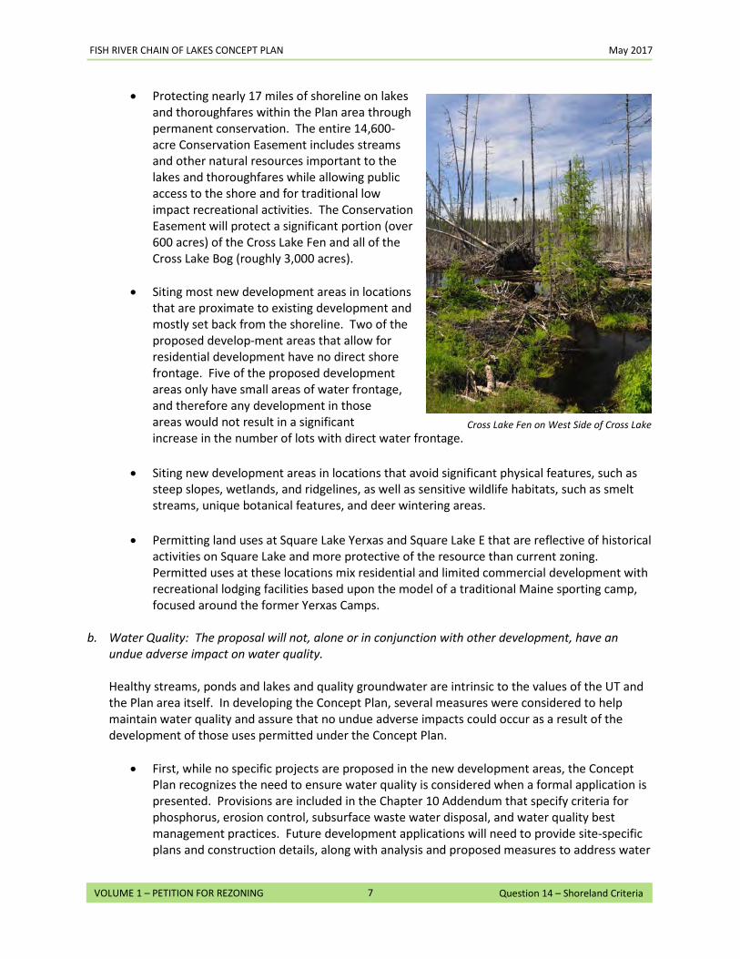
FISH RIVER CHAIN OF LAKES CONCEPT PLAN May 2017
7
VOLUME 1 – PETITION FOR REZONING Question 14 – Shoreland Criteria
• Protecting nearly 17 miles of shoreline on lakes and thoroughfares within the Plan area through permanent conservation. The entire 14,600-acre Conservation Easement includes streams and other natural resources important to the lakes and thoroughfares while allowing public access to the shore and for traditional low impact recreational activities. The Conservation Easement will protect a significant portion (over 600 acres) of the Cross Lake Fen and all of the Cross Lake Bog (roughly 3,000 acres).
• Siting most new development areas in locations
that are proximate to existing development and mostly set back from the shoreline. Two of the proposed develop-ment areas that allow for residential development have no direct shore frontage. Five of the proposed development areas only have small areas of water frontage, and therefore any development in those areas would not result in a significant increase in the number of lots with direct water frontage.
• Siting new development areas in locations that avoid significant physical features, such as
steep slopes, wetlands, and ridgelines, as well as sensitive wildlife habitats, such as smelt streams, unique botanical features, and deer wintering areas.
• Permitting land uses at Square Lake Yerxas and Square Lake E that are reflective of historical
activities on Square Lake and more protective of the resource than current zoning. Permitted uses at these locations mix residential and limited commercial development with recreational lodging facilities based upon the model of a traditional Maine sporting camp, focused around the former Yerxas Camps.
b. Water Quality: The proposal will not, alone or in conjunction with other development, have an
undue adverse impact on water quality.
Healthy streams, ponds and lakes and quality groundwater are intrinsic to the values of the UT and the Plan area itself. In developing the Concept Plan, several measures were considered to help maintain water quality and assure that no undue adverse impacts could occur as a result of the development of those uses permitted under the Concept Plan.
• First, while no specific projects are proposed in the new development areas, the Concept Plan recognizes the need to ensure water quality is considered when a formal application is presented. Provisions are included in the Chapter 10 Addendum that specify criteria for phosphorus, erosion control, subsurface waste water disposal, and water quality best management practices. Future development applications will need to provide site-specific plans and construction details, along with analysis and proposed measures to address water
Cross Lake Fen on West Side of Cross Lake
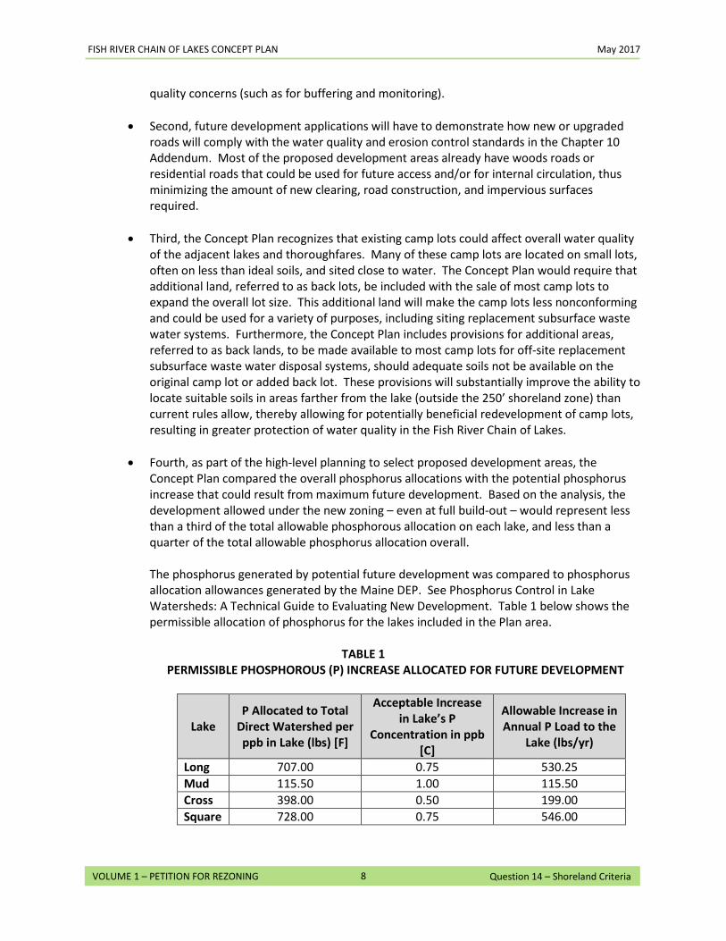
FISH RIVER CHAIN OF LAKES CONCEPT PLAN May 2017
8
VOLUME 1 – PETITION FOR REZONING Question 14 – Shoreland Criteria
quality concerns (such as for buffering and monitoring).
• Second, future development applications will have to demonstrate how new or upgraded roads will comply with the water quality and erosion control standards in the Chapter 10 Addendum. Most of the proposed development areas already have woods roads or residential roads that could be used for future access and/or for internal circulation, thus minimizing the amount of new clearing, road construction, and impervious surfaces required.
• Third, the Concept Plan recognizes that existing camp lots could affect overall water quality of the adjacent lakes and thoroughfares. Many of these camp lots are located on small lots, often on less than ideal soils, and sited close to water. The Concept Plan would require that additional land, referred to as back lots, be included with the sale of most camp lots to expand the overall lot size. This additional land will make the camp lots less nonconforming and could be used for a variety of purposes, including siting replacement subsurface waste water systems. Furthermore, the Concept Plan includes provisions for additional areas, referred to as back lands, to be made available to most camp lots for off-site replacement subsurface waste water disposal systems, should adequate soils not be available on the original camp lot or added back lot. These provisions will substantially improve the ability to locate suitable soils in areas farther from the lake (outside the 250’ shoreland zone) than current rules allow, thereby allowing for potentially beneficial redevelopment of camp lots, resulting in greater protection of water quality in the Fish River Chain of Lakes.
• Fourth, as part of the high-level planning to select proposed development areas, the
Concept Plan compared the overall phosphorus allocations with the potential phosphorus increase that could result from maximum future development. Based on the analysis, the development allowed under the new zoning – even at full build-out – would represent less than a third of the total allowable phosphorous allocation on each lake, and less than a quarter of the total allowable phosphorus allocation overall.
The phosphorus generated by potential future development was compared to phosphorus allocation allowances generated by the Maine DEP. See Phosphorus Control in Lake Watersheds: A Technical Guide to Evaluating New Development. Table 1 below shows the permissible allocation of phosphorus for the lakes included in the Plan area.
TABLE 1
PERMISSIBLE PHOSPHOROUS (P) INCREASE ALLOCATED FOR FUTURE DEVELOPMENT
Lake P Allocated to Total
Direct Watershed per ppb in Lake (lbs) [F]
Acceptable Increase in Lake’s P
Concentration in ppb [C]
Allowable Increase in Annual P Load to the
Lake (lbs/yr)
Long 707.00 0.75 530.25 Mud 115.50 1.00 115.50 Cross 398.00 0.50 199.00 Square 728.00 0.75 546.00
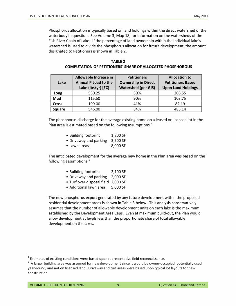
FISH RIVER CHAIN OF LAKES CONCEPT PLAN May 2017
9
VOLUME 1 – PETITION FOR REZONING Question 14 – Shoreland Criteria
Phosphorus allocation is typically based on land holdings within the direct watershed of the waterbody in question. See Volume 3, Map 18, for information on the watersheds of the Fish River Chain of Lake. If the percentage of land ownership within the individual lake’s watershed is used to divide the phosphorus allocation for future development, the amount designated to Petitioners is shown in Table 2.
TABLE 2
COMPUTATION OF PETITIONERS’ SHARE OF ALLOCATED PHOSPHOROUS
Lake Allowable Increase in Annual P Load to the
Lake (lbs/yr) [FC]
Petitioners Ownership in Direct Watershed (per GIS)
Allocation to Petitioners Based
Upon Land Holdings Long 530.25 39% 208.55 Mud 115.50 90% 103.75 Cross 199.00 41% 82.19 Square 546.00 84% 485.14
The phosphorus discharge for the average existing home on a leased or licensed lot in the Plan area is estimated based on the following assumptions.4
• Building footprint 1,800 SF • Driveway and parking 3,500 SF • Lawn areas 8,000 SF
The anticipated development for the average new home in the Plan area was based on the following assumptions.5
• Building footprint 2,100 SF • Driveway and parking 2,000 SF • Turf over disposal field 2,000 SF • Additional lawn area 5,000 SF
The new phosphorus export generated by any future development within the proposed residential development areas is shown in Table 3 below. This analysis conservatively assumes that the number of allowable development units on each lake is the maximum established by the Development Area Caps. Even at maximum build-out, the Plan would allow development at levels less than the proportionate share of total allowable development on the lakes.
4 Estimates of existing conditions were based upon representative field reconnaissance. 5 A larger building area was assumed for new development since it would be owner-occupied, potentially used year-round, and not on licensed land. Driveway and turf areas were based upon typical lot layouts for new construction.
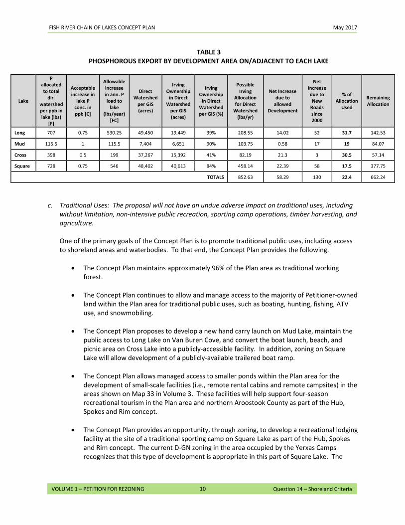
FISH RIVER CHAIN OF LAKES CONCEPT PLAN May 2017
10
VOLUME 1 – PETITION FOR REZONING Question 14 – Shoreland Criteria
TABLE 3 PHOSPHOROUS EXPORT BY DEVELOPMENT AREA ON/ADJACENT TO EACH LAKE
Lake
P allocated to total
dir. watershed per ppb in lake (lbs)
[F]
Acceptable increase in
lake P conc. in ppb [C]
Allowable increase in ann. P load to
lake (lbs/year)
[FC]
Direct Watershed
per GIS (acres)
Irving Ownership
in Direct Watershed
per GIS (acres)
Irving Ownership
in Direct Watershed per GIS (%)
Possible Irving
Allocation for Direct
Watershed (lbs/yr)
Net Increase due to
allowed Development
Net Increase due to New
Roads since 2000
% of Allocation
Used
Remaining Allocation
Long 707 0.75 530.25 49,450 19,449 39% 208.55 14.02 52 31.7 142.53
Mud 115.5 1 115.5 7,404 6,651 90% 103.75 0.58 17 19 84.07
Cross 398 0.5 199 37,267 15,392 41% 82.19 21.3 3 30.5 57.14
Square 728 0.75 546 48,402 40,613 84% 458.14 22.39 58 17.5 377.75
TOTALS 852.63 58.29 130 22.4 662.24
c. Traditional Uses: The proposal will not have an undue adverse impact on traditional uses, including
without limitation, non-intensive public recreation, sporting camp operations, timber harvesting, and agriculture.
One of the primary goals of the Concept Plan is to promote traditional public uses, including access to shoreland areas and waterbodies. To that end, the Concept Plan provides the following.
• The Concept Plan maintains approximately 96% of the Plan area as traditional working
forest.
• The Concept Plan continues to allow and manage access to the majority of Petitioner-owned land within the Plan area for traditional public uses, such as boating, hunting, fishing, ATV use, and snowmobiling.
• The Concept Plan proposes to develop a new hand carry launch on Mud Lake, maintain the
public access to Long Lake on Van Buren Cove, and convert the boat launch, beach, and picnic area on Cross Lake into a publicly-accessible facility. In addition, zoning on Square Lake will allow development of a publicly-available trailered boat ramp.
• The Concept Plan allows managed access to smaller ponds within the Plan area for the
development of small-scale facilities (i.e., remote rental cabins and remote campsites) in the areas shown on Map 33 in Volume 3. These facilities will help support four-season recreational tourism in the Plan area and northern Aroostook County as part of the Hub, Spokes and Rim concept.
• The Concept Plan provides an opportunity, through zoning, to develop a recreational lodging facility at the site of a traditional sporting camp on Square Lake as part of the Hub, Spokes and Rim concept. The current D-GN zoning in the area occupied by the Yerxas Camps recognizes that this type of development is appropriate in this part of Square Lake. The
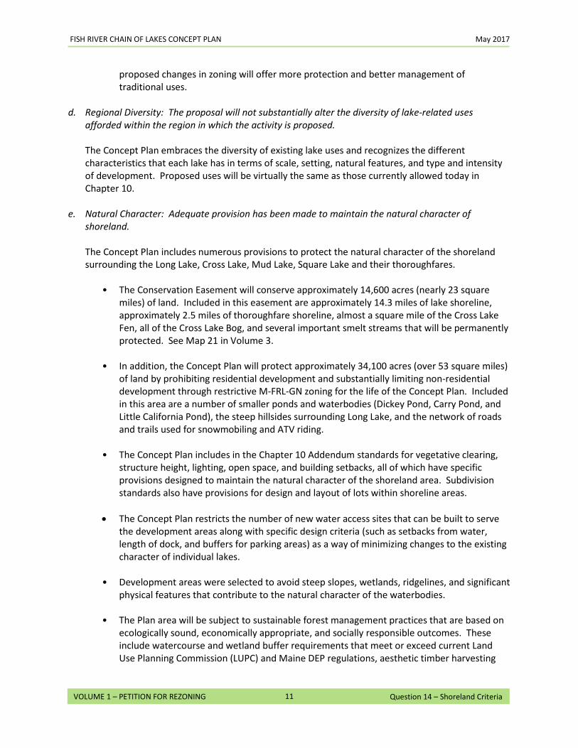
FISH RIVER CHAIN OF LAKES CONCEPT PLAN May 2017
11
VOLUME 1 – PETITION FOR REZONING Question 14 – Shoreland Criteria
proposed changes in zoning will offer more protection and better management of traditional uses.
d. Regional Diversity: The proposal will not substantially alter the diversity of lake-related uses
afforded within the region in which the activity is proposed.
The Concept Plan embraces the diversity of existing lake uses and recognizes the different characteristics that each lake has in terms of scale, setting, natural features, and type and intensity of development. Proposed uses will be virtually the same as those currently allowed today in Chapter 10.
e. Natural Character: Adequate provision has been made to maintain the natural character of
shoreland.
The Concept Plan includes numerous provisions to protect the natural character of the shoreland surrounding the Long Lake, Cross Lake, Mud Lake, Square Lake and their thoroughfares.
• The Conservation Easement will conserve approximately 14,600 acres (nearly 23 square
miles) of land. Included in this easement are approximately 14.3 miles of lake shoreline, approximately 2.5 miles of thoroughfare shoreline, almost a square mile of the Cross Lake Fen, all of the Cross Lake Bog, and several important smelt streams that will be permanently protected. See Map 21 in Volume 3.
• In addition, the Concept Plan will protect approximately 34,100 acres (over 53 square miles)
of land by prohibiting residential development and substantially limiting non-residential development through restrictive M-FRL-GN zoning for the life of the Concept Plan. Included in this area are a number of smaller ponds and waterbodies (Dickey Pond, Carry Pond, and Little California Pond), the steep hillsides surrounding Long Lake, and the network of roads and trails used for snowmobiling and ATV riding.
• The Concept Plan includes in the Chapter 10 Addendum standards for vegetative clearing,
structure height, lighting, open space, and building setbacks, all of which have specific provisions designed to maintain the natural character of the shoreland area. Subdivision standards also have provisions for design and layout of lots within shoreline areas.
• The Concept Plan restricts the number of new water access sites that can be built to serve
the development areas along with specific design criteria (such as setbacks from water, length of dock, and buffers for parking areas) as a way of minimizing changes to the existing character of individual lakes.
• Development areas were selected to avoid steep slopes, wetlands, ridgelines, and significant
physical features that contribute to the natural character of the waterbodies. • The Plan area will be subject to sustainable forest management practices that are based on
ecologically sound, economically appropriate, and socially responsible outcomes. These include watercourse and wetland buffer requirements that meet or exceed current Land Use Planning Commission (LUPC) and Maine DEP regulations, aesthetic timber harvesting
FISH RIVER CHAIN OF LAKES CONCEPT PLAN May 2017
12
VOLUME 1 – PETITION FOR REZONING Question 14 – Shoreland Criteria
practices to minimize the visual impact of harvest operations, maintenance of biological diversity to maintain healthy populations of flora and fauna, and promotion of overall forest health.
f. Lake Management Goals: The proposal is consistent with the management intent of the affected
lakes classification.
Long Lake is approaching Management Class 5, Heavily Developed Status. Under current LUPC zoning, the regulatory emphasis is on retaining the natural qualities of the remaining undeveloped land bordering the lake. Any further shoreline development must be clustered.
The Concept Plan identifies three areas on or near Long Lake as future development areas. With the exception of a few infill lots on the west side of Van Buren Cove and a small portion of Long Lake A on the east side of Van Buren Cove, these development areas are not located on the shoreline. The majority of future development will be on upland sites away from the shoreline, located to take advantage of view opportunities, avoid steep grades, and minimize new road construction. New water access sites in the Plan area are restricted – two for Long Lake A, one for Long Lake B, and none for Long Lake C. The beach at Van Buren Cove will remain a public access point. The steep hillsides on either side of Long Lake are included in the Unique Areas Program due to their topography and the scenic value they contribute to the lake. To prevent erosion and sedimentation and loss of scenic quality, no development areas are sited on these hillsides. The aesthetic timber harvesting practices required by the sustainable forestry principles will govern timber harvesting activities, as discussed in response to Question 20.
Camps on east side of Long Lake at Van Buren Cove
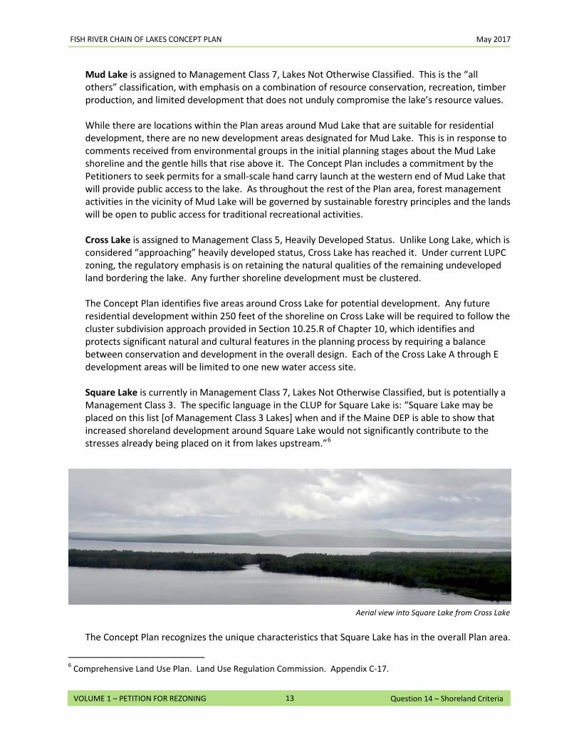
FISH RIVER CHAIN OF LAKES CONCEPT PLAN May 2017
13
VOLUME 1 – PETITION FOR REZONING Question 14 – Shoreland Criteria
Mud Lake is assigned to Management Class 7, Lakes Not Otherwise Classified. This is the “all others” classification, with emphasis on a combination of resource conservation, recreation, timber production, and limited development that does not unduly compromise the lake’s resource values. While there are locations within the Plan areas around Mud Lake that are suitable for residential development, there are no new development areas designated for Mud Lake. This is in response to comments received from environmental groups in the initial planning stages about the Mud Lake shoreline and the gentle hills that rise above it. The Concept Plan includes a commitment by the Petitioners to seek permits for a small-scale hand carry launch at the western end of Mud Lake that will provide public access to the lake. As throughout the rest of the Plan area, forest management activities in the vicinity of Mud Lake will be governed by sustainable forestry principles and the lands will be open to public access for traditional recreational activities. Cross Lake is assigned to Management Class 5, Heavily Developed Status. Unlike Long Lake, which is considered “approaching” heavily developed status, Cross Lake has reached it. Under current LUPC zoning, the regulatory emphasis is on retaining the natural qualities of the remaining undeveloped land bordering the lake. Any further shoreline development must be clustered. The Concept Plan identifies five areas around Cross Lake for potential development. Any future residential development within 250 feet of the shoreline on Cross Lake will be required to follow the cluster subdivision approach provided in Section 10.25.R of Chapter 10, which identifies and protects significant natural and cultural features in the planning process by requiring a balance between conservation and development in the overall design. Each of the Cross Lake A through E development areas will be limited to one new water access site. Square Lake is currently in Management Class 7, Lakes Not Otherwise Classified, but is potentially a Management Class 3. The specific language in the CLUP for Square Lake is: “Square Lake may be placed on this list [of Management Class 3 Lakes] when and if the Maine DEP is able to show that increased shoreland development around Square Lake would not significantly contribute to the stresses already being placed on it from lakes upstream.”6
The Concept Plan recognizes the unique characteristics that Square Lake has in the overall Plan area.
6 Comprehensive Land Use Plan. Land Use Regulation Commission. Appendix C-17.
Aerial view into Square Lake from Cross Lake
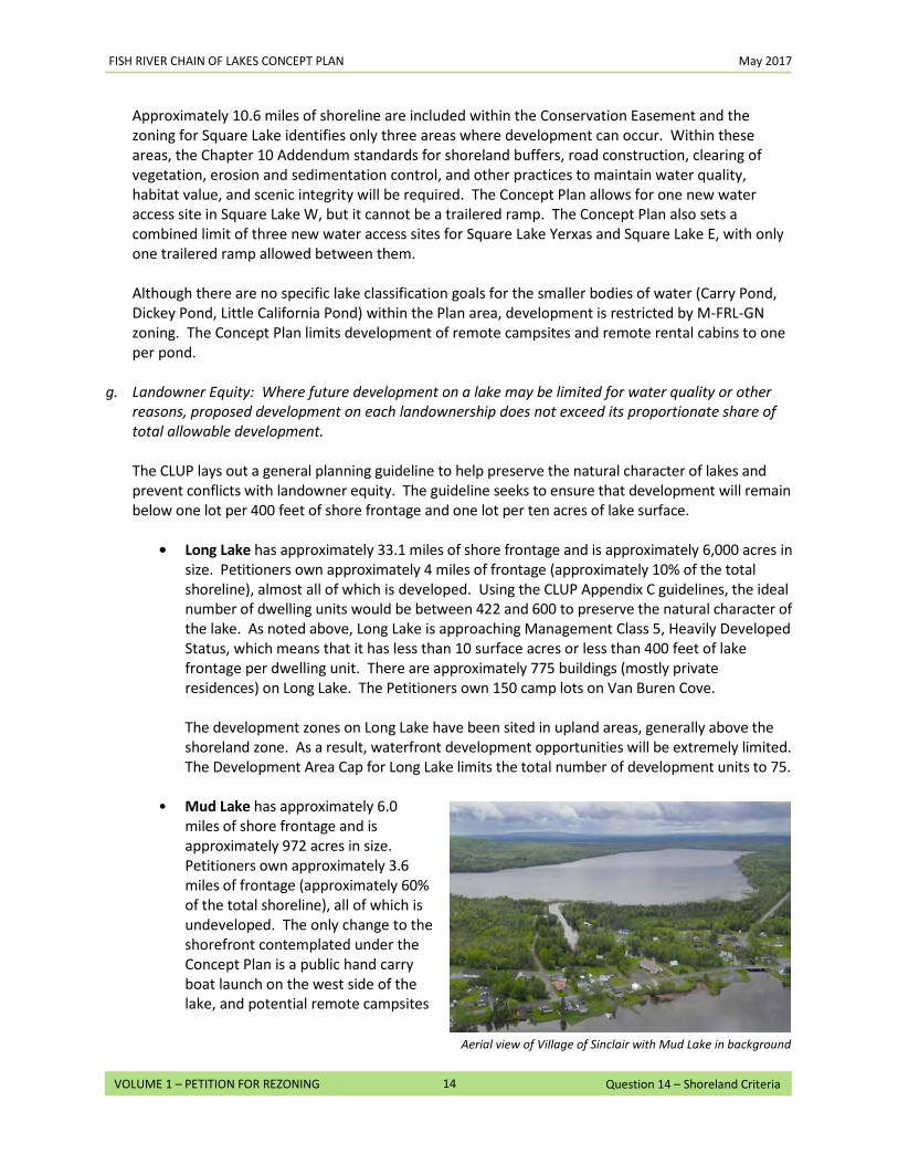
FISH RIVER CHAIN OF LAKES CONCEPT PLAN May 2017
14
VOLUME 1 – PETITION FOR REZONING Question 14 – Shoreland Criteria
Approximately 10.6 miles of shoreline are included within the Conservation Easement and the zoning for Square Lake identifies only three areas where development can occur. Within these areas, the Chapter 10 Addendum standards for shoreland buffers, road construction, clearing of vegetation, erosion and sedimentation control, and other practices to maintain water quality, habitat value, and scenic integrity will be required. The Concept Plan allows for one new water access site in Square Lake W, but it cannot be a trailered ramp. The Concept Plan also sets a combined limit of three new water access sites for Square Lake Yerxas and Square Lake E, with only one trailered ramp allowed between them. Although there are no specific lake classification goals for the smaller bodies of water (Carry Pond, Dickey Pond, Little California Pond) within the Plan area, development is restricted by M-FRL-GN zoning. The Concept Plan limits development of remote campsites and remote rental cabins to one per pond.
g. Landowner Equity: Where future development on a lake may be limited for water quality or other
reasons, proposed development on each landownership does not exceed its proportionate share of total allowable development.
The CLUP lays out a general planning guideline to help preserve the natural character of lakes and prevent conflicts with landowner equity. The guideline seeks to ensure that development will remain below one lot per 400 feet of shore frontage and one lot per ten acres of lake surface.
• Long Lake has approximately 33.1 miles of shore frontage and is approximately 6,000 acres in
size. Petitioners own approximately 4 miles of frontage (approximately 10% of the total shoreline), almost all of which is developed. Using the CLUP Appendix C guidelines, the ideal number of dwelling units would be between 422 and 600 to preserve the natural character of the lake. As noted above, Long Lake is approaching Management Class 5, Heavily Developed Status, which means that it has less than 10 surface acres or less than 400 feet of lake frontage per dwelling unit. There are approximately 775 buildings (mostly private residences) on Long Lake. The Petitioners own 150 camp lots on Van Buren Cove.
The development zones on Long Lake have been sited in upland areas, generally above the shoreland zone. As a result, waterfront development opportunities will be extremely limited. The Development Area Cap for Long Lake limits the total number of development units to 75.
• Mud Lake has approximately 6.0
miles of shore frontage and is approximately 972 acres in size. Petitioners own approximately 3.6 miles of frontage (approximately 60% of the total shoreline), all of which is undeveloped. The only change to the shorefront contemplated under the Concept Plan is a public hand carry boat launch on the west side of the lake, and potential remote campsites
Aerial view of Village of Sinclair with Mud Lake in background
FISH RIVER CHAIN OF LAKES CONCEPT PLAN May 2017
15
VOLUME 1 – PETITION FOR REZONING Question 14 – Shoreland Criteria
and remote rental cabins at designated locations. Approximately 1.7 miles of the Mud Lake shoreline within the Plan area is included in the
Conservation Easement. All of the shoreline falls within applicable protection or management zones that limit development.
• Cross Lake has approximately 13.1 miles of shore frontage and is approximately 2,515 acres
in size. Petitioners own approximately 9 miles of frontage (approximately 69% of the total shoreline). Using the CLUP Appendix C guidelines, the ideal number of dwelling units for a lake of this size would be between 168 and 251 to preserve the natural character of the lake. Cross Lake is, however, already heavily developed, with over 300 camps (including both Petitioner-owned land and non-Petitioner-owned lots) along the shoreline throughout the northern half of the lake. As a result, many of the proposed development zones have been located on upland sites. The Development Area Cap for Cross Lake has been set at 125 units. Development in these areas will be subject to Chapter 10 Addendum rules and will not contribute to significant changes to the shoreline.
• Square Lake has approximately 19.4 miles of shore frontage and is approximately 8,150 acres
in size. Petitioners own approximately 13.9 miles of frontage (approximately 72% of the total shoreline). There are currently less than 60 camps on the lake (19 of which are on sites licensed by Petitioners on the west side of the lake). Using the CLUP Appendix C guidelines, the ideal number of dwelling units would be between 256 and 815 to maintain the natural character of the lake.
The Development Area Cap for Square Lake has been set at 130 units, well below the numbers derived from the Appendix C guidelines. Development in these areas will be subject to Chapter 10 Addendum rules and will not contribute to significant changes to the shoreline. The majority of the new development would be located away from the shorefront, thus minimizing potential impacts on the natural character of the lake. Furthermore, the Concept Plan would place approximately 10.6 miles of the Square Lake shoreline in permanent conservation. In addition, all the land above the Eagle Lake thoroughfare would be placed in permanent conservation (the State already owns a 250-foot strip on either side of the thoroughfare).
• Carry Pond, Dickey Pond, Little California Pond are in zones that prohibit residential and
commercial development and allow for one small facility (remote campsite or remote cabin no larger than 750 square feet).
15. Anticipated Favorable Impacts: Do you anticipate that your proposed use of the land would result in any favorable impacts on any of the surrounding land, resources, and/or uses in the community or area? If so, describe in detail the anticipated favorable impacts.
Approval of the Concept Plan will have a number of favorable impacts to the land, resources, and uses within and surrounding the Plan area. Overall, the Concept Plan will provide the Petitioners and the public with a comprehensive blueprint for the future. The Concept Plan identifies and prescribes those areas within the Plan area that are appropriate for future development, as well as those areas where the conservation of natural resources is a priority. The anticipated benefits from approval of the Petition include:
• Sustainable Working Forest. One of the goals of the Concept Plan is to sustain the working
forest, which is fundamental to the culture, character, and economy of Northern Aroostook County. First and foremost, ensuring that large unfragmented blocks of productive forestland are maintained and protected improves the long-term viability of the forest resource and the forest products industries that are dependent upon a continuous supply of wood and fiber. Over 95% of the 51,015-acre Plan area will be protected for working forest uses through M-FRL-GN zoning. In addition, approximately 14,600 acres of land will be placed in a permanent conservation easement that is aimed at preserving the working forest. The Easement Area alone is more than 28% of the total Plan area. To enhance the health and productivity of the working forest, the Plan area will be managed by sustainable forestry practices, which include Outcome Based Forestry (OBF) principles. These practices, which address water quality, soil productivity, timber quality, aesthetics, biodiversity, and other considerations, provide a flexible, science-based platform for managing forest operations and activities. Please refer to the response to Question 20 for more information, including a detailed discussion of the benefits of OBF.
• Organized Development. As noted in the Comprehensive Land Use Plan (CLUP), development is
an expected part of life in the unorganized territory (UT). The manner in which development occurs, however, can have a significant effect on the character and vibrancy of an area. The Concept Plan is an ideal alternative to the potential for unplanned growth that could occur within the Plan area under existing rules. Left unchanged, the result could be poorly sited subdivisions, incompatible land uses, unchecked shoreline development, and unnecessary fragmentation of the forest resource. Under the current rules, lots could be created in many locations that would result in a haphazard, sprawling pattern of development. Under the 2-in-5-year exception to subdivision requirements, the number of lots that could be created over time within the Plan area is dramatic. For example, at the theoretical maximum, over 900 new lots could be created using the 2-in-5 exception in the Plan area over the 30-year term of the Concept Plan. This level of development could limit access to and forever change the character of the area. See the response to Question 21 for more information on the potential impact of the 2-in-5 exception on the Plan area. In contrast to that scenario, the Concept Plan has identified those areas that are appropriate for future development. The planning process started with an analysis of the physical
FISH RIVER CHAIN OF LAKES CONCEPT PLAN May 2017
2
VOLUME 1 – PETITION FOR REZONING Question 15 – Anticipated Favorable Impacts
characteristics and existing development patterns in the Plan area from a landscape perspective (see the response to Question 9 and Appendix A for information on existing conditions). This analysis was based on current data on infrastructure and land use, natural resources, topography, soils, drainage patterns, existing access roads, and other relevant information to identify suitable areas for potential future growth. As a result, the location and size of the new development areas were sited based on proximity to existing similar development, historical development patterns, and avoidance of significant natural resources. The development areas are generously sized to allow flexibility in siting future roads and lots, and to provide space for buffers, trail corridors, common areas, and other amenities. This approach also provides the flexibility to minimize – or avoid altogether – potential adverse impacts to existing natural resources, some of which may not be fully identified and mapped as part of this planning process or may change over time (e.g., wetlands and vernal pools). The Concept Plan also limits the intensity of development that could occur on Long, Cross, and Square Lake by placing restrictions on the total number of units that can be constructed in the development areas surrounding each lakes over the life of the Concept Plan. In addition, the Concept Plan prescribes the number of units and commercial lots that could be created within each development area. At the site level, once the Concept Plan is approved, all future development will be subject to review under the Chapter 10 Addendum, which establishes appropriate standards to guide and regulate development. The Chapter 10 Addendum conforms to and in many cases is more stringent than current Land Use Planning Commission (LUPC) standards. For more information on how the Concept Plan conforms to the Commission’s standards, please see the response to Question 19.
• Diversity of Opportunities. One of the attributes of the Plan area and surrounding communities is the diversity of development opportunities, which include forest products, recreational tourism, and a variety of residential development. The Concept Plan supports this broad mix of economic opportunities, which provides an opportunity to strengthen the surrounding communities, and in turn should provide an economic stimulus to the region. In particular, development of these areas should result in increased employment opportunities, while the additional taxable income from residential, commercial, or industrial development could contribute to the general economic health and well-being of Aroostook County.
o Residential. While the Concept Plan limits residential development to specific locations and numbers, it offers opportunities for a diverse range of housing types and ownership. Housing diversity – in the form of single family lots, cluster development, and seasonal camps in various forms of ownership, among others – should attract people of all income levels and interests, rather than catering only to seasonal shorefront buyers. The addition of more year-round residents could benefit local businesses throughout the year, provide new opportunities for commercial growth, and help to provide the population needed to support local organizations that largely depend upon volunteers for staffing and organizational support.
o Tourism. According to the CLUP, tourism benefits the rural economy of the UT in a
number of ways, including supporting local commerce, maintaining the local property
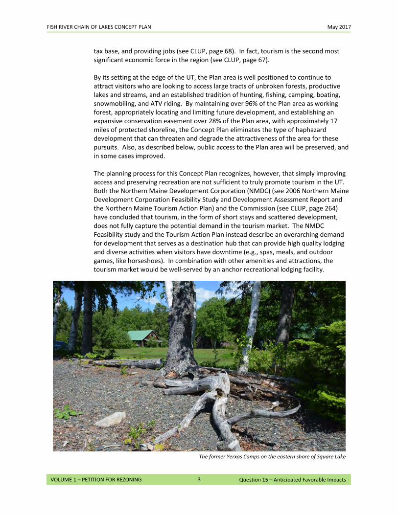
FISH RIVER CHAIN OF LAKES CONCEPT PLAN May 2017
3
VOLUME 1 – PETITION FOR REZONING Question 15 – Anticipated Favorable Impacts
tax base, and providing jobs (see CLUP, page 68). In fact, tourism is the second most significant economic force in the region (see CLUP, page 67). By its setting at the edge of the UT, the Plan area is well positioned to continue to attract visitors who are looking to access large tracts of unbroken forests, productive lakes and streams, and an established tradition of hunting, fishing, camping, boating, snowmobiling, and ATV riding. By maintaining over 96% of the Plan area as working forest, appropriately locating and limiting future development, and establishing an expansive conservation easement over 28% of the Plan area, with approximately 17 miles of protected shoreline, the Concept Plan eliminates the type of haphazard development that can threaten and degrade the attractiveness of the area for these pursuits. Also, as described below, public access to the Plan area will be preserved, and in some cases improved. The planning process for this Concept Plan recognizes, however, that simply improving access and preserving recreation are not sufficient to truly promote tourism in the UT. Both the Northern Maine Development Corporation (NMDC) (see 2006 Northern Maine Development Corporation Feasibility Study and Development Assessment Report and the Northern Maine Tourism Action Plan) and the Commission (see CLUP, page 264) have concluded that tourism, in the form of short stays and scattered development, does not fully capture the potential demand in the tourism market. The NMDC Feasibility study and the Tourism Action Plan instead describe an overarching demand for development that serves as a destination hub that can provide high quality lodging and diverse activities when visitors have downtime (e.g., spas, meals, and outdoor games, like horseshoes). In combination with other amenities and attractions, the tourism market would be well-served by an anchor recreational lodging facility.
The former Yerxas Camps on the eastern shore of Square Lake
FISH RIVER CHAIN OF LAKES CONCEPT PLAN May 2017
4
VOLUME 1 – PETITION FOR REZONING Question 15 – Anticipated Favorable Impacts
The Fish River Chain of Lakes, by its interconnected nature and setting in an extensive woodland environment, is well-suited to attract such a destination tourism facility – particularly one with a core (Hub) facility offering lodging and amenities, connections to other parts of the Plan area and beyond through trail or other connections (Spokes), and supported by satellite (Rim) attractions (such as scenic locations, cultural heritage events) and complimentary businesses (such as guide services, equipment rentals, restaurants, and grocery stores). The Concept Plan allows for and promotes the establishment of such a Hub, Spokes, and Rim system. The Hub for such a system would be focused on the development of a recreational lodging facility at the historic Yerxas Camps on Square Lake. Lodging could be patterned after what the NMDC Feasibility Study describes as a “frontier” facility, with cabins and other accommodations of varying sizes and accompanying amenities. To promote the development of the Hub, for ten years after the effective date of Concept Plan, the D-FRL-RF zone only allows development of single- and two-family residential uses in Square Lake Yerxas if they are developed as part of or subsequent to a recreational lodging facility. The Spokes could be ATV, snowmobile, or hiking trails on land, and the lakes, thoroughfares, and navigable streams on water. Rim facilities already exist in the Plan area (such as Limestone Point and Van Buren Cove) and in surrounding communities, such as Fort Kent (Nordic Center, 10th Mountain Center, 9-hole golf course), Saint Agatha (Sportsmen’s Club, Lakeview Restaurant), and New Sweden (cultural sites). Other rim facilities could be developed in the surrounding communities and in the community and economic development areas. The Concept Plan also allows for the development of small-scale remote rental cabins and remote campsites in a number of prescribed areas, which could support the Hub facility and act as an additional draw. In combination, the Hub, Spokes, and Rim concept has the potential to be the crown jewel of the Plan area.
o Local Trades and Employment. The Concept Plan provides the framework to enhance the region’s economy by promoting well-planned development that respects and conserves the natural environment. This will, in turn, support many of the traditional economic activities of the region –outfitters, guides, restaurants, and local trades – and provide further opportunities to pursue community and economic development projects while preserving the fundamental character of the Plan area. An increase in population over time would also provide a larger customer base for local businesses and service providers. Finally, and perhaps most significantly, by promoting the working forest, the Concept Plan will help to preserve and even create jobs, such as those for loggers, truckers, and foresters, that are the core of the forest products industry. A recent study entitled Economic Contribution of Maine’s Forest Products Industry 2014 and 2016 (Estimated), published by the Maine Forest Council in June 2016 and conducted by the School of Forest Resources at the University of Maine, indicated that the forest products industry can account for over 5,000 jobs in Aroostook County (including direct and indirect jobs).
• Preserving Public Access. The use of the Plan area and its associated waterbodies for hunting, fishing, camping, boating, snowmobiling, ATV riding, and other recreational activities is an
FISH RIVER CHAIN OF LAKES CONCEPT PLAN May 2017
5
VOLUME 1 – PETITION FOR REZONING Question 15 – Anticipated Favorable Impacts
intrinsic part of the culture of the region. The Concept Plan guarantees public access throughout the vast majority of the Plan area for low-impact recreational uses and for managed motorized uses, in keeping with current tradition and practices. This is significant for a number of reasons. For example, the beach at Van Buren Cove on Long Lake will remain a public access point. This has been a popular public swimming and picnicking spot for many years, even though there is currently nothing that requires it be accessible to the public. The site provides good access in the winter for ice fishing and snowmobiling on the lake and is an informal launching place for canoes and kayaks. The beach has also been used heavily in the past by the Town of Van Buren to support several of its outdoor recreational programs.
• Improving Public Access. The Concept Plan provides increased access to the waterbodies within the Plan area. First, after approval, Petitioners will seek permits to develop a hand carry launch on Mud Lake. There is currently no public access on the lake. Officials from both the Maine Department of Inland Fisheries and Wildlife (IF&W) and the Maine Bureau of Public Lands (BPL) have stated that providing such access would be beneficial. Second, the Petitioners have also committed to ensuring that the Cross Lake boat launch, beach, and picnic area will be made open to the public. This site is currently leased to a private sportsmen group and is not required to be publicly accessible under the terms of that lease. However, it has traditionally been the major access point into Cross Lake and also into Square Lake through the Cross Lake / Square Lake thoroughfare. Third, on Square Lake the Concept Plan would allow a publicly-accessible trailered ramp in either Square Lake Yerxas or Square Lake E (but not both). Further, the Concept Plan requires development of such a ramp if a recreational lodging facility is built at Square Lake Yerxas, unless one has already been developed in either Square Lake Yerxas or Square Lake E. These zoning changes create the opportunity to carefully improve access to the second largest lake in Aroostook County, which Maine IF&W considers to be underutilized from a fisheries perspective. See Map 33 in Volume 3 for the location of these sites. For more information on preserving and improving public access, please refer to the response to Question 10. Conservation of Habitat and Natural Resources. As discussed in detail in response to Question 20, the Plan area includes a wide range of habitat and natural resource values. For example, the Cross Lake Fen near the western shore of Cross Lake is an ecological site of statewide significance. There are also multiple deer wintering areas (DWAs) (some of which have been designated voluntarily by the Petitioners via a cooperative agreement with the State), inland waterfowl and wading bird habitats, bald eagle and osprey nests, and other significant natural features. See Volume 3, Maps 19 and 20 for the location of these resources. Many of these areas have been recognized for their significance and mapped as part of Irving’s Unique Areas Program and the State of Maine Natural Areas Program. Siting of the development areas took these natural resources into account by either avoiding them and/or incorporating them into the Conservation Easement. The Concept Plan provides that DWAs will continue to be identified and managed pursuant to an agreement with the State to maintain or improve their quality. Landowners will be required to continue active monitoring and updating
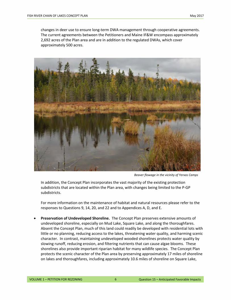
FISH RIVER CHAIN OF LAKES CONCEPT PLAN May 2017
6
VOLUME 1 – PETITION FOR REZONING Question 15 – Anticipated Favorable Impacts
changes in deer use to ensure long-term DWA management through cooperative agreements. The current agreements between the Petitioners and Maine IF&W encompass approximately 2,692 acres of the Plan area and are in addition to the regulated DWAs, which cover approximately 500 acres.
In addition, the Concept Plan incorporates the vast majority of the existing protection subdistricts that are located within the Plan area, with changes being limited to the P-GP subdistricts. For more information on the maintenance of habitat and natural resources please refer to the responses to Questions 9, 14, 20, and 22 and to Appendices A, D, and E.
• Preservation of Undeveloped Shoreline. The Concept Plan preserves extensive amounts of undeveloped shoreline, especially on Mud Lake, Square Lake, and along the thoroughfares. Absent the Concept Plan, much of this land could readily be developed with residential lots with little or no planning, reducing access to the lakes, threatening water quality, and harming scenic character. In contrast, maintaining undeveloped wooded shorelines protects water quality by slowing runoff, reducing erosion, and filtering nutrients that can cause algae blooms. These shorelines also provide important riparian habitat for many wildlife species. The Concept Plan protects the scenic character of the Plan area by preserving approximately 17 miles of shoreline on lakes and thoroughfares, including approximately 10.6 miles of shoreline on Square Lake,
Beaver flowage in the vicinity of Yerxas Camps
FISH RIVER CHAIN OF LAKES CONCEPT PLAN May 2017
7
VOLUME 1 – PETITION FOR REZONING Question 15 – Anticipated Favorable Impacts
approximately 2.0 miles of shoreline on Cross Lake, and approximately 1.7 miles of shoreline on Mud Lake. For more information on the preservation of undeveloped shoreline, please refer to the response to Question 22.
• Viewshed Protection. The Concept Plan subjects the Plan area to ongoing sustainable forest management practices based on OBF principles, which include minimizing the aesthetic impacts of timber harvesting. For more information, please see the response to Question 20. The Concept Plan also establishes new buffer standards that will apply to the community and economic development areas and to water access sites. In addition, the Concept Plan adopts the existing standards on scenic character (Chapter 10 Addendum § 10.25,E) as an Amendable Provision, which means that any revisions that LUPC makes to these rules in the future will also apply to the Plan area. To improve the scenic character of Square Lake, Petitioners have also committed to seeking permits within two years of the effective date of the Concept Plan to remove any of the buildings at the Yerxas Camps site that cannot be reasonably restored or preserved. See photographs of existing conditions at the Yerxas Camps in the response to Question 12.
• Planning for the Potential Sale of Camp Lots. The Plan area includes approximately 425 existing camp lots that are either leased or licensed from Petitioners. Most of these lots were developed prior to the establishment of LUPC or its predecessor, the Land Use Regulation Commission, and are legally nonconforming relative to current standards. The Concept Plan provides a process to manage the potential impacts of the sale of these lots that was developed in consultation with a soils scientist and licensed site evaluator. The majority of the lots will be expanded with additional land (known as Back Lots) that will make them less non-conforming with current standards and may, in particular, be used for siting replacement subsurface waste water disposal systems. In most cases the Back Lots will have land areas located outside of the 250 foot shoreland zone, thus improving the chances that replacement systems could be located in areas of suitable soils and at greater distances from the shoreline. In nearly all situations where a replacement system could not be sited on a Back Lot, the Petitioners will make available access to additional lands (known as Back Lands) within 400 feet of the shorefront, and as far away as 2,500 feet from the individual camp lot where such systems might be sited. These steps will significantly reduce the likelihood that replacement systems would impact water quality in the Fish River Chain of Lakes and thus represents a significant potential benefit to the Plan area. In addition to addressing the waste water issue, all camp lots will, upon sale, be deeded guaranteed vehicular and utility access over the existing road network in the Plan area and be subject to deed restrictions requiring the new lot owners to join road associations established to maintain existing access roads.
• Leveraging Existing Public Reserve Lands. The 14,600-acre conservation easement is strategically located next to the 23,000-acre Eagle Lake Public Reserve Land, managed by the
FISH RIVER CHAIN OF LAKES CONCEPT PLAN May 2017
8
VOLUME 1 – PETITION FOR REZONING Question 15 – Anticipated Favorable Impacts
Maine BPL. This Reserve Land is regularly used for the same types of recreational activities that are popular in the Plan area and similarly provides significant wildlife habitat, including most of the eastern portion of Eagle Lake. By locating the conservation easement adjacent to this area, the Plan leverages this existing Public Reserve Land to create a much more significant recreational and ecological unit. The Easement area also abuts the State’s 83-acre Parker Bog parcel, which is part of the Cross Lake Fen complex.
• Long-Term Predictability for the Landowner. The approval of the Concept Plan will assist Petitioners in making long-term decisions regarding forest management and future development of the Plan area with a high degree of predictability. By identifying and restricting areas designated for development, Petitioners can make the necessary and appropriate adjustments to their investments in long-term forest management and fine tune harvesting activities within a given area.
16. Anticipated Unfavorable Impacts: Do you anticipate that your proposed use of the land would result in any unfavorable impacts on any of the surrounding land, resources, and/or uses in the community or area? If so, describe in detail the anticipated unfavorable impacts and any measures proposed to control or minimize them.
Other than a small hand carry launch on Mud Lake, no development projects are being proposed in this Petition. If and when development does occur, we do not anticipate any unfavorable impacts to the surrounding land, resources and/or uses in the Plan area. As part of the process for developing the Concept Plan, potential unfavorable impacts were examined. Potential impacts were either avoided or otherwise mitigated as described below.
• Impacts From Water Access Sites. Additional residential development will lead to more people
using the lakes for a variety of recreational pursuits. Added boaters may increase pressure on publicly available water access sites or create demand for new water access sites. These changes may lessen the experience of individuals who use the waterbodies and have grown accustomed to the current level of boating activity. The Concept Plan provides a combination of rules and restrictions on new water access sites and includes careful planning of where such points can be located.
First, the Concept Plan limits the number of new water access sites that can be developed within the Plan area, as noted below. A water access site is a lot or common area primarily used for the accommodation of a docking structure, hand carry launch, and/or trailered ramp that provides common access to multiple users. This approach will require future developments to consider shared access for upland sites, thus minimizing the impacts from such activities on the scenic character of the applicable waterbody.
• Long Lake A is limited to 2 new water access sites. • Long Lake B is limited to 1 new water access site. • Long Lake C will have no water access sites. • Cross Lake A is limited to 1 new water access site. • Cross Lake B is limited to 1 new water access site. • Cross Lake C is limited to 1 new water access site. • Cross Lake D is limited to 1 new water access site. • Cross Lake E is limited to 1 new water access site. • Square Lake E and Square Lake Yerxas are limited to a total of 3 new water access sites
(only one of which may be a trailered ramp). • Square Lake W is limited to 1 new water access site (which may not be a trailered ramp). • Mud Lake, Carry Pond, Dickey Pond, and Little California Pond are each limited to
development of a hand carry launch. Second, the Concept Plan adds specific standards for development of new water access sites. The Chapter 10 Addendum provides dimensional standards (lot size, shore frontage, road frontage, setbacks) and buffering standards for any water access site that is developed in the Plan area. These standards were included to mitigate unintended impacts from water access development to the shoreline and adjacent residential properties. Standards differ with the scale of the water access facility. For example, hand carry launch sites (which should have a minimal level of impact) require
FISH RIVER CHAIN OF LAKES CONCEPT PLAN May 2017
2
Question 16 – Anticipated Unfavorable Impacts VOLUME 1 – PETITION FOR REZONING
a limited amount of shorefront, while facilities with docks and parking (which may have a greater impact) will require a larger area and more shorefront. Additionally, the rules will establish more stringent buffering standards between both neighboring properties and the water body for parking areas that serve water access sites. Third, the Concept Plan adds new water access sites in strategic locations to provide additional public access to lakes that are now underserved. In meetings during the development of the Concept Plan, Maine IF&W and the Bureau of Parks and Lands representatives have suggested that providing additional public access points to Mud Lake and Square Lake would be beneficial. In response to these suggestions, the Petitioners are committing to seek approvals for, and develop (provided approvals are obtained) a hand carry launch on Mud Lake, which currently has no public shoreline access. Maine IF&W currently does not stock Mud Lake, due, in part, to the lack of access. Development of the launch would remove this obstacle and provide opportunities for fishing and boating. In addition, the Concept Plan zones Square Lake Yerxas and Square Lake E to allow a publicly-accessible trailered ramp, recognizing that the existing private ramp at the north end of the lake is in very poor condition and limits the size of boats that can access the lake. Fourth, to avoid overburdening the lakes, the Chapter 10 Addendum allows the Commission to approve a trailered ramp on both Long Lake and Cross Lake only as a special exception and only upon a showing that there is a demonstrated need. This allows trailered ramps to be developed, provided it is clear that existing facilities cannot adequately meet the demand. Furthermore, any trailered ramp developed in the Plan area after the effective date of the Concept Plan must be accessible to the public.
• Changes to Lake Character. Unregulated waterfront development could be seen as an unwelcome
intrusion by adjacent or nearby residents or boaters who are accustomed to the current conditions on the lakes. To avoid such impacts, most of the proposed development areas are set back from the shoreline in upland areas where new homes will not be visible from the water, resulting in minimal change to the character of the lakes. The Concept Plan limits the total number of new development units within the residential development area (and Square Lake Yerxas) to 330. Additionally, each lake is restricted by development area caps, which limit the number of new development units that can be built in the proposed development areas. For example, the maximum number of new units permitted in the Long Lake development areas is 75, which is a small fraction (about 7%) of the residential units already located at the lake. The majority of these will be in upland areas away from the shoreline and thus the impact, even if fully developed, would be minimal. Siting and limiting development in this manner will minimize the amount of nutrient-rich runoff that enters the lakes. The development area caps will also limit additional boating and fishing pressure on the lakes, which is in keeping with LUPC policies for shorefront development. Any shorefront development that does occur under the Concept Plan would be required to meet the applicable standards in the Chapter 10 Addendum for waterfront development, including stringent standards for setbacks from the water and lighting. These standards will minimize any potential visual impacts on lake character. Appendix C, Evaluation of Impacts to Recreation, provides a detailed analysis of the potential impact
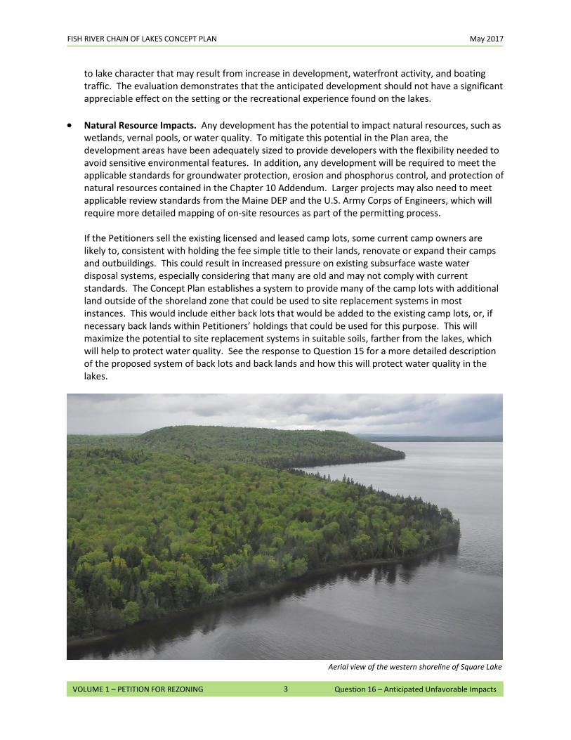
FISH RIVER CHAIN OF LAKES CONCEPT PLAN May 2017
3
Question 16 – Anticipated Unfavorable Impacts VOLUME 1 – PETITION FOR REZONING
to lake character that may result from increase in development, waterfront activity, and boating traffic. The evaluation demonstrates that the anticipated development should not have a significant appreciable effect on the setting or the recreational experience found on the lakes.
• Natural Resource Impacts. Any development has the potential to impact natural resources, such as
wetlands, vernal pools, or water quality. To mitigate this potential in the Plan area, the development areas have been adequately sized to provide developers with the flexibility needed to avoid sensitive environmental features. In addition, any development will be required to meet the applicable standards for groundwater protection, erosion and phosphorus control, and protection of natural resources contained in the Chapter 10 Addendum. Larger projects may also need to meet applicable review standards from the Maine DEP and the U.S. Army Corps of Engineers, which will require more detailed mapping of on-site resources as part of the permitting process. If the Petitioners sell the existing licensed and leased camp lots, some current camp owners are likely to, consistent with holding the fee simple title to their lands, renovate or expand their camps and outbuildings. This could result in increased pressure on existing subsurface waste water disposal systems, especially considering that many are old and may not comply with current standards. The Concept Plan establishes a system to provide many of the camp lots with additional land outside of the shoreland zone that could be used to site replacement systems in most instances. This would include either back lots that would be added to the existing camp lots, or, if necessary back lands within Petitioners’ holdings that could be used for this purpose. This will maximize the potential to site replacement systems in suitable soils, farther from the lakes, which will help to protect water quality. See the response to Question 15 for a more detailed description of the proposed system of back lots and back lands and how this will protect water quality in the lakes.
Aerial view of the western shoreline of Square Lake
FISH RIVER CHAIN OF LAKES CONCEPT PLAN May 2017
4
Question 16 – Anticipated Unfavorable Impacts VOLUME 1 – PETITION FOR REZONING
• Secondary Development Pressure. If the development permitted in the Plan area occurs, there is
the potential that lands adjoining the designated development areas could become more attractive for development after the Concept Plan has expired. In some instances, secondary development might be desirable and appropriate (for example, as a way to achieve higher critical mass that may be needed to support community initiatives or businesses). Secondary development that is unanticipated and dispersed could, however, have an unfavorable impact on sensitive wildlife habitat, prominent hillsides, and the undeveloped shoreline of places like Square Lake, all of which are highly valued in the region. The types of secondary development pressure that are typically of concern involve shoreline development, hillside development, and areas of high recreational value. Shoreline Development. Undeveloped shorelines are particularly susceptible to secondary development pressure. While the Concept Plan specifies where any new shoreline development can occur (both new and in-fill), there are significant portions of the lakes, ponds and thoroughfares remaining undeveloped. In the planning process, these undeveloped shorelines were examined to evaluate the potential for secondary development and develop appropriate measures to prevent unanticipated growth in the most critical areas. For more information, see Figures 3 through 16 provided in the response to Question 12 illustrating how secondary development pressure will be contained.
o Long Lake. There are approximately 4 miles of shoreline on Long Lake within the Plan area. Of that, approximately 3 miles are already intensively developed with seasonal and year-round homes. The Concept Plan includes three new development areas, primarily on upland sites adjacent to existing waterfront development. The beach at Van Buren Cove will remain undeveloped and continue to serve as a major recreational resource for the nearby camp owners, as well as a public access point. The beach and surrounding area are not likely to see any secondary development pressure due to the limited land area, as well as its natural constraints: wetlands, stream, and wildlife habitat. The undeveloped shoreline at the north end of Long Lake B is also unlikely to see development pressure due to its steep slopes.
o Mud Lake. There are approximately 3.6 miles of undeveloped shoreline on Mud Lake within the Plan area. Apart from a small hand carry launch, which is unlike to create any secondary development pressure on its own, there are no development areas proposed for Mud Lake as part of the Concept Plan. Secondary development is highly unlikely, due to the hydric soils and high value wetlands that make up the shoreline. In addition, 1.7 miles of the western shoreline of Mud Lake are with the Conservation Easement, which restricts development in perpetuity.
o Cross Lake. Of the 9.0 miles of shoreline the Petitioners owns on Cross Lake, approximately
4.84 miles are already developed with camp lots. While the Concept Plan allows development in five separate development areas on the lake, the majority of the designated land is in upland locations (Cross Lake A, B, C, and most of D), adjacent to existing waterfront lots. Cross Lake E, at the southern end of the lake, and a small portion of Cross Lake D, would allow development on an additional 0.9 mile of shoreline. Of the remaining
FISH RIVER CHAIN OF LAKES CONCEPT PLAN May 2017
5
Question 16 – Anticipated Unfavorable Impacts VOLUME 1 – PETITION FOR REZONING
undeveloped shoreline, two areas – at the southern end of the lake near the Cross Lake/Square Lake thoroughfare, and the western shoreline near the Cross Lake Fen – are protected in perpetuity by the Conservation Easement. The remaining undeveloped shoreline outside of the Easement area is unlikely to see secondary development pressure due to natural constraints. This includes an extensive wetland system associated with Daigle Brook and Dickey Brook at the northern end of the lake, and the shoreline below an area of very steep topography between Cross Lake D and Cross Lake E.
o Square Lake. Of the 13.9 miles of shoreline that Petitioners own on Square Lake,
approximately one mile is already developed with camp lots. The Concept Plan proposes two adjoining development areas on the east side of the lake (Square Lake E and Square Lake Yerxas) and one area (Square Lake W) on the west side. The east side of the lake, in the vicinity of the proposed residential and recreational lodging areas, may anticipate secondary development pressure due to the attractiveness of the setting and the recreational resources associated with the lake. To prevent development along the waterfront outside of the designated development areas in Square Lake Yerxas and Square Lake E, the Concept Plan has included the shoreline on either side of Square Lake E in the Conservation Easement. In total, 10.6 miles of the shoreline will be permanently protected, thus precluding development pressure along the attractive lakefront. A small area on the west side of the lake (between existing camp lots south of Limestone Point and Square Lake W) may also see some limited development pressure in the future. While this would be an appropriate location for future growth, the presence of natural constraints (such as steep slopes and wetlands), lack of utilities, and distance and uncertainty of access from main roads will limit the overall potential.
o Smaller Ponds. There are no development areas proposed near the three ponds (Little
California Pond, Dickey Pond, and Carry Pond) within the Plan area. To maintain their current character while providing a basic recreational amenity, the Concept Plan limits potential development around these water bodies to a single small remote rental cabin or remote campsite. Secondary development around these ponds is unlikely (particularly for Little California Pond and Dickey Pond) due to their remoteness and the extent of the wetlands that surround them.
o Thoroughfares. The Concept Plan anticipates that there will be a minor amount of
secondary development on one of the thoroughfares connecting the lakes.
o Petitioner does not own any of the frontage in the Long Lake / Mud Lake thoroughfare.
o The thoroughfare from Mud Lake to the transmission corridor in Cross Lake TWP is within the Conservation Easement and will not be developed. In the short distance from the transmission line south to Cross Lake, however, there are several areas where development could occur after the Concept Plan expires. This area is appropriate given that it is within walking distance of the existing general store at Guerette, is easily accessed from Route 161, and is proximate to compatible development. Additional residential and commercial development in this area,
FISH RIVER CHAIN OF LAKES CONCEPT PLAN May 2017
6
Question 16 – Anticipated Unfavorable Impacts VOLUME 1 – PETITION FOR REZONING
which would be subject to the Chapter 10 Addendum, could help foster growth in Cross Lake TWP.
o There will be no secondary development on the south side of the Cross Lake / Square Lake thoroughfare, since it will all be included in the Conservation Easement, except for the existing Fraser Camp, which is privately owned.
o The Square Lake / Eagle Lake thoroughfare will likewise be permanently protected. Both sides of the thoroughfare are part of the Eagle Lake Public Reserve Land. Petitioners’ land that abuts the Public Reserve Land will all be part of the Conservation Easement.
Hillside Development. Ridgelines and hillsides overlooking the lakes may be susceptible to secondary development pressures, especially where they are adjacent to proposed development areas. On Long Lake, Cross Lake, and Square Lake, Petitioners’ holdings include some hillside locations that could be subject to secondary development pressure after the Concept Plan expires. The application of the Chapter 10 Addendum standards for hillside development, home siting, road construction, and other forms of infrastructure will be important to preserve the character of these sites as well as the views from the lakes in order to minimize impacts to recreational resources and the scenic character. In addition, the Chapter 10 Addendum standards for hillside development have been adopted as Amendable Provisions, and therefore any revisions to these rules by LUPC in the future will apply to the Plan area. Areas of high recreational value. Square Lake, in particular, is widely recognized in the state for its size (second largest lake in Aroostook County), limited amount of development, outstanding fishing, and other recreational values. The Concept Plan identifies three areas where future development can occur with minimal impact on the overall character of the lake. Over 10.6 miles of undeveloped shoreline and most of the Petitioners’ upland area surrounding the lake will be part of the Conservation Easement to ensure that the underlying character of Square Lake is permanently protected. As noted in Appendix C, Square Lake is large enough to absorb the limited amount of development allowed under the Concept Plan. The development authorized by the Concept Plan should not have a significant effect on the setting or the recreational experience found on the lake. Any development proposed after the Concept Plan expires would be subject to the Chapter 10 Addendum rules in place at that time. Under current regulations, further development within the Plan area would require either amending this Plan or allowing it to expire and subjecting the Plan area to whatever zoning LUPC deems appropriate in the future. Once this occurs, further development would have to meet those LUPC regulations that are in place at the time. Thus, to the extent that potential secondary development is seen as unfavorable, it will be mitigated by the rezoning and development review process that applies once a concept plan expires.
• Compatibility of Uses. The Concept Plan identifies areas appropriate for development and specifies permitted uses within these areas through the Chapter 10 Addendum. However, it is recognized that, in some situations, permitted uses might not be compatible with one another.
o Conflicts between working forest and public access. Public access within the working forest is a long-standing tradition in Maine that will continue within the Plan area. However, the
FISH RIVER CHAIN OF LAKES CONCEPT PLAN May 2017
7
Question 16 – Anticipated Unfavorable Impacts VOLUME 1 – PETITION FOR REZONING
addition of residential/recreational development in certain areas might increase the potential for conflicts with working forest operations, especially with vehicles hauling forest products. To minimize conflicts, the Concept Plan specifies which roads should be used to access new development areas with the goal of separating the general public from the main haul roads. See Map 36 in Volume 3.
o Conflicts between working forest and adjacent residential use. Working forest operations
may come into conflict with residential use from time to time, particularly when active operations abut established communities. While this is not uncommon for this part of the state, the adoption sustainable forestry principles requires forest management to address social considerations and incorporate aesthetics into active forestry operations.
o Conflicts between community and economic development areas and adjacent uses. The CD
areas are in locations adjacent to existing similar uses. However, despite this, there may be some locations where the development allowed within the CD areas might not be compatible with adjacent uses. To mitigate any unfavorable impacts, the Concept Plan provides rules for setbacks, building size, buffering, density, and other considerations that will protect existing land uses while offering the opportunity for community-scale economic development.
17. Public Services: What municipal, county, or other services (i.e., solid waste disposal, fire and police protection, schools and school transportation, etc.) will your proposed use of the land require? Describe by what means these public services will be obtained.
The following public services may be required for any future development that occurs following the effective date of the Concept Plan. More detailed information is provided in the report, Existing Conditions in the Plan area, which is included in Appendix A.
• Solid Waste. Solid waste is generally picked up by private haulers or individual camp owners
and transported to one of two landfills: Tri-Community Landfill in Fort Fairfield or the Town of Van Buren’s municipal landfill. It is anticipated that this arrangement would continue with any new development.
• Fire Protection. The Aroostook County North Lakes Fire and Rescue (North Lakes Fire & Rescue)
has three substations covering four unorganized territories in Aroostook County. The substations serve the northern part of Aroostook County, covering Cross Lake, Mud Lake, Long Lake, Madawaska Lake, and Square Lake. North Lakes Fire & Rescue has entered into written mutual-aid agreements with the Towns of Stockholm, St. Agatha, and Fort Kent, and the Caribou Fire and Ambulance Department. It is anticipated that fire protection for future development would continue to be provided by North Lakes Fire & Rescue or the Town of Van Buren, depending on the location of the call.
• 911 Calls. Emergency calls to 911 from landlines go to Penobscot County, while calls from cell
phones are handled by the Houlton Police. All calls are then transferred to Aroostook County for dispatch. It is anticipated that this service will continue.
• Law Enforcement. Law enforcement services are handled on a rotating basis by the Maine State
Police and the County Sheriff. The County is subdivided into five zones for law enforcement and the responsibility for those zones changes weekly.
• Transportation. The Plan area includes portions of two State-maintained arterial roads (Routes
161 and 162). These roads will continue to be the primary transportation routes to and from the Plan area and no significant impacts are anticipated due to potential future development. There are multiple private roads in the Plan area.
There are airports in Frenchville, Caribou, and Presque Isle. There is no public transportation in the Plan area.
• Education. Education in the Plan area is administered by the State Department of Education’s
Education in the Unorganized Territory (EUT) program. Education options may require unique solutions due to the remote and rural nature of the Plan area and may depend on the specific location of the child in relation to the available educational facilities. If there is an existing school within a reasonable distance of the child, the EUT would make arrangements for the child to attend that school. If there is no reasonable option available, then the EUT works with the family to establish a program that the family would administer similar to a home school plan. In some instances, the EUT will support room and board for alternative programming, such as computer generated educational programs.
FISH RIVER CHAIN OF LAKES CONCEPT PLAN May 2017
2
VOLUME 1 – PETITION FOR REZONING Question 17 – Public Services
As with all Maine schools, the EUT financially supports transportation to and from school via local buses for all students K-12. At times, they are not able to support grades 9-12 students, nor do they make special arrangements for pre-K students. To provide transportation, the EUT uses a variety of options, such as personal contracts, hired bussing services, EUT buses, and, on occasion, four wheelers and boats.
18. Compliance With Laws and Standards: If your proposal includes a subdivision or development proposal, provide information in response to the following questions concerning whether the land is likely to be suitable for the proposed use.
Other than the hand carry launch at Mud Lake, there are no development proposals being included as part of the Concept Plan. Rather, the Concept Plan identifies areas where development can and should occur in the future and provides standards by which these developments will be reviewed. During the life of the Concept Plan, future projects will be required to meet the applicable standards for development, such as subdivision review or site plan approval. During these review processes, more detailed information will be required on items ranging from wetland impacts to archaeological surveys.
a. Water Supply: What provisions will be made for securing and maintaining a healthy water supply to the area?
There will be no need for potable water at the proposed Mud Lake hand carry launch. It is anticipated that virtually all other new development would be served by on-site wells or a community water supply system. Provisions for securing and maintaining a healthy water supply will be the responsibility of the developer and addressed at the time any new development is proposed. See Section 10.25,J of the Chapter 10 Addendum.
b. Soil Conditions: Are soil conditions appropriate for proposed uses, particularly in areas proposed for development?
The hand carry launch proposed at Mud Lake is located in an area that is mapped as Canandaigua silt loam in the Natural Resources Conservation Service soil survey. See soil suitability assessment in Exhibit D. Canandaigua is rated as “Generally Unsuitable” due to wetness, with a seasonal high water table at or near the surface. The use of boardwalks and pedestrian bridges, as necessary, is a common technique to help overcome the inherent limitations of these soil conditions, as well as to help to avoid the wetter parts of the site and minimize impacts on the surrounding wetlands. With proper engineering, it should be possible to install and maintain the hand carry launch in a fashion that provides an appropriate level of access to Mud Lake. It should be noted that this soil series underlies several of the waterfront homes that are east of the proposed hand carry site. As part of the planning process for the Concept Plan, the soil characteristics of the proposed development areas were evaluated to determine if there is a reasonable likelihood that the soils could support permitted uses and the allowable level of development. That review concluded that in all the new residential development areas there is a reasonable likelihood that existing soils can support the type and intensity development that would be permitted. The assessment also shows that the community and economic development areas appear to have somewhat lower potential for development because they are located in areas dominated by hydric soils. However, the soils report notes that there are likely to be inclusions of suitable soils within the community and economic development areas that could be identified with a more detailed on-site investigation. In addition, the Chapter 10 Addendum limits the development potential of CD-1, CD-2, and CD-4 development areas to no more than 50% of the area.
FISH RIVER CHAIN OF LAKES CONCEPT PLAN May 2017
2
VOLUME 1 – PETITION FOR REZONING Question 18 – Compliance With Laws and Standards
Where soils conditions present limitations for development there are a number of common construction techniques that can be employed to overcome them. For example, road construction can overcome water table limitations associated with hydric soils by using ditching, cross drains, and rock sandwich construction techniques. Building construction can employ appropriate stormwater management techniques and foundation footing drains. In areas of steep slopes, development could occur on smaller benches or in areas of moderate to gentle slopes. In areas of shallow bedrock, development can be sited on smaller inclusions of deeper soils. Road and building construction may require blasting or ripping of bedrock in some areas. However, this can provide a potential source for borrow material that can be used in the region for road subgrades and fill. Overall, the Chapter 10 Addendum (specifically Section 10.25,G) contains standards that require development projects to include construction techniques and best management practices to overcome any on-site soils limitations. This would include a soils analysis as part of any specific development project that may be proposed in the Plan area. See Exhibit D for a soil suitability assessment for the Plan area as a whole and a more focused Class C/D soil survey of the Square Lake E and Square Lake Yerxas development areas.
c. Traffic: What provisions will be made for parking and safe traffic flow?
Parking for the proposed Mud Lake hand carry launch may be either off road in a separate parking area, or simply in a widened shoulder adjacent to Route 162. The determination of where to locate the parking area is a decision that will be made during the permitting process and in consultation with Maine Department of Transportation (DOT). See Volume 3, Map 35 for an illustration. The scale of future projects is not likely to generate any negative impacts to Route 161 and 162. This was confirmed by Maine DOT representatives during a meeting on August 21, 2013, with LUPC staff, at which they indicated that the anticipated amount of new traffic generated from development allowed within the Plan area would not have an unreasonable effect on current level of service. The Concept Plan includes several standards that require future development applications to address parking, traffic flow, and other transportation issues. This includes limiting the number of driveway cuts on to Route 161 for Cross Lake B, parking layout/design (see Section 10.25,D of the Chapter 10 Addendum), and buffers provisions for parking areas associated with water access facilities (see Section 10.29,C of the Chapter 10 Addendum).
Safe traffic flow for new/expanded residential development areas is addressed in the Concept Plan by designating certain roads as access routes that will minimize conflicts with ongoing forest management operations (see Volume 3, Map 36 Access to Development Areas).
FISH RIVER CHAIN OF LAKES CONCEPT PLAN May 2017
3
VOLUME 1 – PETITION FOR REZONING Question 18 – Compliance With Laws and Standards
d. Erosion Control: What provisions will be made for stabilization and erosion control of the site?
Provisions for stabilization, sedimentation and erosion control – including an erosion control plan and use of Best Management Practices – will be required at the time any development is proposed pursuant to Section 10.25,M of the Chapter 10 Addendum. This will also apply to the design and permitting for the hand carry launch at Mud Lake.
e. Subsurface Waste Water Disposal: What provisions will be made to comply with the requirements of the Subsurface Waste Water Disposal Rules of the Maine State Plumbing Code?
As noted in response to Question 18(b) above, part of the planning process for the Concept Plan included a review of the general soil characteristics of the proposed development areas. That review concluded that there is a reasonable likelihood that existing soils can support development, or, in areas where high level mapping indicates the prevalence of hydric soils, there are likely to be inclusions of suitable soils for subsurface waste water disposal. In any future development scenario, on-site investigations will be required to determine the location, size, and design of subsurface waste water disposal systems. Development areas were sized to provide suitable space for compliance with the State Plumbing Code. Section 10.25,I of the Chapter 10 Addendum provides applicable standards for subsurface waste water disposal systems. As discussed in greater detail in response to Question 16, the Concept Plan anticipates the potential sale of over 400 existing licensed or leased camp lots within the Plan area. The Concept Plan establishes a system to provide most of these lots with additional lands outside of the shoreland zone that could be used to site replacement subsurface waste water disposal systems. These Back Lots will be added to most of the camp lots to accommodate replacement systems. If necessary, Back Lands within Petitioners’ holdings will be made available in most cases to accommodate replacement systems. This approach will maximize the potential to site replacement subsurface waste water disposal systems in suitable soils and farther away from the lakes, which will help to protect water quality. The rules on this process, set out in Section 10.31 in the Chapter 10 Addendum, do not exempt such lots from or otherwise amend the application of the Subsurface Waste Water Disposal Rules of the Maine State Plumbing Code, which is administered by the Department of Health and Human Services.
f. Harmonious Fit: What measures will be taken to fit the proposal into the existing
surroundings? Include any special considerations given to siting, design, size, coloring, landscaping or other factors that will lessen the impact of the proposal on the surroundings.
The planning process for the Concept Plan started with an analysis of the physical characteristics and existing development patterns in the Plan area at the landscape level. This analysis considered data on infrastructure and land use, natural resources, topography, soils, drainage patterns, and other factors to identify suitable areas for future growth. As a result, the location and size of new development areas take into account proximity to existing similar development, historical development patterns, and avoidance of significant natural resources to achieve a
FISH RIVER CHAIN OF LAKES CONCEPT PLAN May 2017
4
VOLUME 1 – PETITION FOR REZONING Question 18 – Compliance With Laws and Standards
harmonious fit with the surrounding area. See Maps 9-13 and Maps 19-20 in Volume 3. At the zoning level, the Concept Plan specifies the type and intensity of uses that are permitted within the Plan area to assure that development will continue to work harmoniously with other attributes of the Plan area. The proposed areas and their associated zones are modeled after existing Chapter 10 subdistricts with some changes to support the overall objectives of the Concept Plan and to better reflect the character of the Plan area itself. The key zoning modifications include:
• Recreational lodging facilities was removed as a permitted use from the D-FRL-CI zone to better maintain compatibility of uses within the commercial/industrial area and to focus recreational lodging development in Square Lake Yerxas.
• Residential development, home occupations, and recreational lodging were removed as
permitted uses within the D-FRL-GN zone. In addition, multi-family residential development is a special exemption in this zone, and only allowed as an affordable housing development.
• Single and two-family residential development and residential subdivisions have been
reclassified in the D-FRL-RF zone as a special exception for the first 10 years of the Concept Plan, and only if part of a recreational lodging development. While residential development can be compatible with, and may even be necessary financially to support a recreational lodging development, recreational lodging should be the main priority in this location.
• Home occupations, residential development, and recreational lodging were removed
from the M-FRL-GN zone. Also, remote campsites and remote camps are allowed, but limited to specific areas indicated in the Concept Plan.
• Residential development will not be allowed in the P-FRL-GP and P-FRL-WL subdistricts.
The Concept Plan also limits the intensity of development that could occur on Long, Cross, and Square Lakes by placing restrictions on the total number of residential units that could be constructed in the development areas associated with each lake over the life of the Concept Plan. In addition, the Concept Plan sets a limit on the number of residential units and commercial lots that could be created within each proposed development area. To limit density, the Concept Plan also limits the area that can be developed in the CD-1, CD-2 and CD-4 development areas to no more than 50%. At the site level, once the Concept Plan is approved, all future development will be subject to review under the Chapter 10 Addendum, which establishes appropriate standards to guide and regulate development. The Chapter 10 Addendum conforms to, and, in many cases, is more stringent than current LUPC standards. The Concept Plan also provides overall subdivision design guidelines that call for careful building siting and layout. The Chapter 10 Addendum includes illustrations of planning principles that are designed to promote good siting and responsible development. For more information on how the Concept Plan conforms to the Land
FISH RIVER CHAIN OF LAKES CONCEPT PLAN May 2017
5
VOLUME 1 – PETITION FOR REZONING Question 18 – Compliance With Laws and Standards
Use Planning Commission’s standards, please see the response to Question 19.
g. Scenic Impacts: What measures will be taken to minimize impacts of the proposal on the scenic quality of the area? Consideration should be given to visibility from roads and water bodies.
As noted above, at the landscape level the new development areas have been sited to maintain a harmonious fit with the surrounding area. The Concept Plan also contains specific provisions to address scenic impacts at the site level. This is particularly important in several specific situations, as discussed below. Development near water bodies: The Concept Plan provides approximately 17 miles of permanently conserved lake and thoroughfare shoreline. There are, however, some areas where waterfront development will be allowed in the form of residential development, water access sites (public or private), remote campsites and remote rental cabins, or a recreational lodging facility. Any new residential structure within the Plan area will have a minimum 100-foot setback from the water (see Section 10.26,D of the Chapter 10 Addendum). Within this 100-foot setback, shoreline vegetation needs to be preserved and cleared openings in the forest canopy are limited (see Section 10.27,B of the Chapter 10 Addendum). This will help to minimize the visual impact of new development and maintain shoreline continuity as seen from the waterbody. For water access sites that include parking areas, a vegetated or landscaped buffer at least 75 feet wide is required to help maintain an effective visual screen from the water (See Section 10.27,L,2,k of the Chapter 10 Addendum). Subdivisions within 250 feet of a waterbody need to be clustered, which will help preserve open space and shoreline character (see Sections 10.25,Q and 10.25,R of the Chapter 10 Addendum). Development in scenic locations such as hillsides: Development that occurs in elevated locations can affect views from lakes and public roads. The Chapter 10 Addendum (specifically Section 10.25,E) contains specific guidelines and siting techniques to protect scenic character. These provisions address the design, location, and landscaping of proposed developments; ridgeline preservation; and siting to avoid blocking or interrupting scenic views as seen from traveled ways, water bodies, or public property. These rules are retained in the Concept Plan as an Amendable Provision, and thus any future revisions will apply to the Plan area. Commercial development near roads or residential uses: The community and economic development areas are sited near main roads (Route 161 and 162) and existing similar development. The Chapter 10 Addendum contains provisions to mitigate potential scenic impacts from commercial and industrial development in these areas, including reducing the maximum height limit to 35 feet for any structure located within 250 feet of the travelled portion of Route 162; and requiring a buffer strip to minimize the visual impacts on surrounding uses. Noise standards are included in Section 10.25,F,1 of the Chapter 10 Addendum to help assure projects are compatible with one another. The Concept Plan also contains provisions in Section 10.25,F,2 that limit light trespass from new development (such as requiring shielded light fixtures).
Timber Harvesting in Development Zones: All forest management activities are subject to sustainable forestry practices in Section 10.30 of the Chapter 10 Addendum. These practices
FISH RIVER CHAIN OF LAKES CONCEPT PLAN May 2017
6
VOLUME 1 – PETITION FOR REZONING Question 18 – Compliance With Laws and Standards
require harvesting operations to address activities next to public roads; watercourse and wetland buffers (which typically meet or exceed current Maine Department of Environmental Protection (DEP) regulations); aesthetic timber harvesting practices; maintenance of biological diversity to maintain healthy populations of flora and fauna; and promotion of overall forest health. For more information, see the response to Question 20.
h. Wildlife Habitat: What measures will be made to minimize impacts on wildlife habitat including birds and waterfowl? Consideration should be given to riparian zones along water bodies. The Mud Lake hand carry boat launch was sited at the northwestern end of the lake, immediately adjacent to an area that has been developed with shoreline homes. The facility will be designed to minimize disturbance to sensitive habitats through the use of elevated boardwalks and bridges to gain access to the launch site. Information from Irving’s Unique Areas Program (which includes data from State and federal agencies and staff from the Irving organization) has been used to identify critical habitats, wildlife corridors, and other significant natural resources. The Unique Areas Program was used in conjunction with other data sources to determine where to site development areas to avoid these resources. Riparian buffers, deer wintering areas, wetlands, streams, and other critical habitats will continue to be protected under the applicable standards adopted in the Chapter 10 Addendum and the rules of other State and federal agencies, such as the Maine DEP and U.S. Army Corps of Engineers. Also, the Conservation Easement on approximately 14,600 acres and restrictive zoning on approximately 34,500 additional acres will protect wildlife habitats by substantially restricting development in the majority of the Plan area. For more information, please see the response to Questions 21 and 22 on conservation measures.
19. Conformance with Commission’s Standards: Does the proposal meet or exceed the Commission’s normal standards for site suitability, including the Commission’s minimum dimensional requirements? If the plan includes any provisions that deviate from the Commission’s Land Use Districts and Standards, explain in detail how the provisions differ from the Commission’s rules and provide reasons for the proposed deviations.
The Concept Plan meets the Land Use Planning Commission’s ( LUPC’s) standards by incorporating the vast majority of the existing Chapter 10 rules for site suitability. Some of these standards are “frozen” as currently written, meaning that they are applicable throughout the Plan area in their current form during the life of the Concept Plan. Subsequent amendments to such frozen provisions would not be applicable to the Plan area. Key rules in this category include phosphorus control (Section 10.25,L) and erosion and sedimentation control (Section 10.25,M). Other standards, known as Amendable Provisions, also will be applicable throughout the Plan area in their current form and any subsequent LUPC amendments to these provisions would apply to the Plan area, unless the subject matter of the revision has already been addressed by another provision in Chapter 10 Addendum. Key rules in this category include scenic character (Section 10.25,E), protected natural resources (Section 10.25,P), roads and water crossings (Section 10.27,D), timber harvesting (Section 10.27,E), filling and grading (Section 10.27,F), driveways (Section 10.27,H), pesticide application (Section 10.27,I), and signs (Section 10.27,J).
In some instances, the Concept Plan proposes amendments to the existing standards to ensure that future development will be appropriate to the Plan area and will not have an undue adverse impact on existing resources. Key modifications to the existing Chapter 10 rules include the following:
• Noise. The Concept Plan modifies the noise standards to clarify that certain traditional
activities, such as forestry operations and the use of off-road motor vehicles (including snowmobiles and ATVs) are exempt from the noise requirements of Section 10.25,F,1,a. This reflects the context and culture of the working forest and the traditional recreational activities prevalent in the Plan area. See Chapter 10 Addendum, Section 10.25,F,1,b.
• Lighting. The Concept Plan adds new restrictions designed to limit light pollution in Section
10.25,F,2,b. This will help preserve the nighttime environment and retain the rural character of the Plan area by reducing glare and indirect sky glow. See Chapter 10 Addendum, Section 10.25,F,2,b.
• Subdivision Exemption for Recreational Facilities. The Concept Plan modifies the subdivision
rules to allow without subdivision review up to eight remote rental cabins, remote campsites, or public water access sites within a contiguous ownership larger than 5,000 acres within a township. Currently, the rules provide that only remote rental cabins in such circumstances may be developed without subdivision review. The revised Chapter 10 Addendum allows for a greater diversity of recreational opportunities, which will promote the Hub, Spokes, and Rim system. See Chapter 10 Addendum, Section 10.25,Q,1,d.
• Subdivision Exemption for Camp Lots. The Plan area contains approximately 425 camp lots,
many of which predate the formation of the Land Use Regulation Commission and are legally nonconforming. The Concept Plan provides that the sale of an existing camp lot in the Plan area
FISH RIVER CHAIN OF LAKES CONCEPT PLAN May 2017
2
Question 19 – Conformance with Commission’s Standards VOLUME 1 – PETITION FOR REZONING
does not count as a division for purposes of subdivision review. This will help make the transition from the current arrangements to individual home ownership more efficient and will facilitate the granting of additional Back Lots that will make most of these lots less non-conforming. See Chapter 10 Addendum, Section 10.25,Q,1,g,9.
• Community Centers. The Concept Plan revises the lot layout and design criteria for subdivisions
to more clearly define a “community center” as it pertains to the Plan area. This change provides clarity for future development projects and more accurately reflects the character of the area where a community center is likely to be located. Community centers may be a common open space, a trail network, a water access facility, or other similar features. See Chapter 10 Addendum, Section 10.25,Q,3,b.
• Cluster Development. To promote cluster development, the Concept Plan provides additional
flexibility to authorize LUPC, at its discretion, to reduce any dimensional standard for individual dwelling units or lots in a cluster development, rather than just lot size, road frontage, or shore frontage, which is the current Chapter 10 standard. See Chapter 10 Addendum, Section 10.25,R,2,d.
• Minimum Lot Size for Residential Uses. The Concept Plan establishes a minimum lot size of
20,000 square feet for single- and two-family dwellings, and a minimum lot size of 40,000 square feet for multi-family dwellings. This more accurately reflects the size of existing lots currently in the Plan area and promotes more efficient land use within the development areas. A more compact development approach, combined with the Development Area Caps that limit overall density, will result in more open space and less sprawl, and better maintenance of the forest resource. See Chapter 10 Addendum, Section 10.26,A,1.
• Minimum Lot Size for Water Access Sites. The Concept Plan establishes a new minimum lot size
of 20,000 square feet for water access sites, except for public trailered ramps, which will require at least 40,000 square feet. These standards, in conjunction with additional setback and buffering requirements (see below), will ensure an appropriate neighborhood scale for water access facilities and allow water access for upland residential development areas to fit harmoniously into existing developed shorelines. See Chapter 10 Addendum, Section 10.26,A,4.
• Minimum Frontage for Water Access Sites. The Concept Plan provides minimum shoreline
frontage and road frontage standards that are specific to water access sites: 100 feet for hand carry-launches, 100 feet per dock for docking structures, and 200 feet for trailered ramps. These shore frontage provisions are designed to allow water access facilities to fit in with existing shorefront lots while also requiring additional width based on the intensity of the potential use. See Chapter 10 Addendum, Sections 10.26,B,1 and 10.26,B,2, and 10.26,C, 1.
• Minimum Setbacks for Water Access Sites. The Concept Plan establishes a new setback for
hand carry launches, docking structures, and trailered ramps from side and rear property lines of 20 feet. This will help ensure, along with new buffering requirements, that such uses will have minimal adverse effect on neighboring properties. See Chapter 10 Addendum, Section 10.26,D,2,f.
FISH RIVER CHAIN OF LAKES CONCEPT PLAN May 2017
3
Question 19 – Conformance with Commission’s Standards VOLUME 1 – PETITION FOR REZONING
• Community and Economic Development Area Density. The Concept Plan establishes new limits on the number of lots that may be developed in each of the community and economic development areas. In addition, development of CD-1, CD-2, and CD-4 will be restricted to no more than 50% of the gross development area. These provisions will limit the overall density of development, ensure the preservation of natural resources, maintain adequate buffers, and allow future layouts to incorporate established ATV and snowmobile trails. See Chapter 10 Addendum, Section 10.26,A,5.
• Setbacks. The Concept Plan requires a 30-foot minimum setback from interior roads in
developments in the D-FRL-RS and D-FRL-GN zones. This is a reduction from the current setback of 50 feet and is more reflective of existing development patterns within the Plan area, where residential structures are often built close to existing roads. See Chapter 10 Addendum, Section 10.26,D,1,d. In addition, in the CD-2 and CD-3 development areas, the minimum front setback from the travelled portion of Route 161 will be 25 feet to provide visibility for future commercial activities and to discourage the siting of parking lots between the road and the buildings. See Chapter 10 Addendum, Section 10.26,D,2,g. Setbacks for CD-1 and CD-4 are 75 feet from the traveled portion of Route 162 in order to preserve vegetation along the highway. See Chapter 10 Addendum, Section 10.26,D,2,g.
• Development Footprint. In addition to the existing maximum lot coverage standards and provisions for the size of commercial structures within the D-FRL-GN zone, the footprint of any structures in the CD-1 and CD-4 development areas shall not exceed 4,000 square feet for any portion of the structure within 250 feet of the travelled portion of Route 162. This provision minimizes the overall impact of development as viewed from Route 162 and helps to maintain a harmonious fit. See Chapter 10 Addendum, Section 10.26,E,6.
• Maximum Height. The Concept Plan reduces the maximum height limits for structures from 75
feet to 35 feet for residential uses, and from 100 feet to 60 feet for commercial, industrial, and other non-residential uses. In the CD-1, CD-2, and CD-3 development areas, the maximum structure height within 250 feet of Routes 161 and 162 is further reduced to 35 feet to minimize potential adverse impacts to the scenic and natural character of the Plan area. See Chapter 10 Addendum, Sections 10.26,F,1 and 10.26,F,5.
• Buffers. The Concept Plan establishes extensive buffering requirements in the community and
economic development areas to minimize visual impacts on surrounding uses and to help maintain compatibility between adjacent uses that may not be compatible. See Chapter 10 Addendum, Section 10.25,E,3.
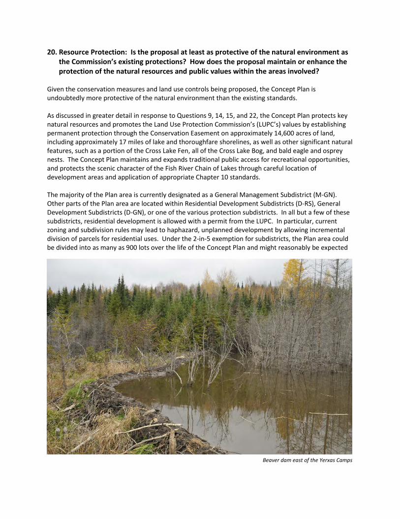
20. Resource Protection: Is the proposal at least as protective of the natural environment as the Commission’s existing protections? How does the proposal maintain or enhance the protection of the natural resources and public values within the areas involved?
Given the conservation measures and land use controls being proposed, the Concept Plan is undoubtedly more protective of the natural environment than the existing standards.
As discussed in greater detail in response to Questions 9, 14, 15, and 22, the Concept Plan protects key natural resources and promotes the Land Use Protection Commission’s (LUPC’s) values by establishing permanent protection through the Conservation Easement on approximately 14,600 acres of land, including approximately 17 miles of lake and thoroughfare shorelines, as well as other significant natural features, such as a portion of the Cross Lake Fen, all of the Cross Lake Bog, and bald eagle and osprey nests. The Concept Plan maintains and expands traditional public access for recreational opportunities, and protects the scenic character of the Fish River Chain of Lakes through careful location of development areas and application of appropriate Chapter 10 standards.
The majority of the Plan area is currently designated as a General Management Subdistrict (M-GN). Other parts of the Plan area are located within Residential Development Subdistricts (D-RS), General Development Subdistricts (D-GN), or one of the various protection subdistricts. In all but a few of these subdistricts, residential development is allowed with a permit from the LUPC. In particular, current zoning and subdivision rules may lead to haphazard, unplanned development by allowing incremental division of parcels for residential uses. Under the 2-in-5 exemption for subdistricts, the Plan area could be divided into as many as 900 lots over the life of the Concept Plan and might reasonably be expected
Beaver dam east of the Yerxas Camps
FISH RIVER CHAIN OF LAKES CONCEPT PLAN May 2017
2
VOLUME 1 – PETITION FOR REZONING Question 20 – Resource Protection
to see over 200 new lots over a 30-year period. While the pace and amount of development might seem substantially restricted, the end result could be unplanned and scattered lots that have the potential to impact the shorelines and create greater fragmentation of the forest. In contrast, the Concept Plan limits future development to those areas that are most appropriate, while prohibiting residential development in areas zoned for forestry (M-FRL-GN). All but two of the proposed residential areas have been sited adjacent to existing development in an effort to maintain large, unfragmented forest areas. Most of the proposed residential development areas are located on upland sites, set back from the shoreline. The community and economic development areas have been sited near public roads and in areas adjacent or proximate to developed centers already zoned for compatible uses. The result is that less than 4% of the total Plan area will be available for future residential development, keeping the vast majority of the land in forest management under sustainable forestry principles. The uses allowed within most subdistricts are based on the existing Chapter 10 standards. Within the planned development areas the standards are modeled after the D-RS, D-CI, and D-GN Subdistricts. Key revisions include allowing certain small-scale stores, commercial recreational uses, and restaurants by special exception in the CD-1 development area, and prohibiting certain types of development that would otherwise be allowed in the M-FRL-GN zone, such as recreational lodging facilities, single- and two-family homes, solid waste disposal facilities, and Level 2 subdivisions. In addition, given the 30-year term of the Concept Plan, and the uncertainty regarding future development activity, the Concept Plan initially allows timber harvesting to occur in all development areas, but only pursuant to an LUPC permit once an application for development has been submitted for any given development area. Furthermore, the proposed D-FRL-RF zone for Square Lake Yerxas has been designed to require a focus on a recreational lodging development because residential development in this development area can only occur in conjunction with a recreational lodging project during the first 10 years of the Concept Plan. This will help to ensure that development proposals will fit harmoniously into the existing character of Square Lake and provide an incentive to develop the recreational anchor in support of the Hub, Spoke, and Rim system discussed in earlier questions. The great majority of the Land Use Standards from Chapter 10 are incorporated into the Concept Plan without revision, as discussed in response to Question 19. This includes the general criteria for approval of permit applications, development standards, and dimensional requirements. Utilizing most of the existing land use standards will help to ensure that all future projects have minimal effects on the natural, cultural, and visual environment of the Plan area. The dominant use of the Plan area is and will remain commercial forestry. As described in Appendix D, the Irving organization is a leader in innovative forest management practices and is guided by principles of sustainable forestry. Irving has already committed to these principles through management criteria set out in the Outcome Based Forestry (OBF) program of the Maine Forest Service, which, pursuant to 12 M.R.S. § 8869(3-A), is a cooperative approach to forestry that “must provide at least the equivalent forest and environmental protection as provided by existing rules.” In fact, many aspects of Irving’s management practices under OBF are stricter than the requirements of the Maine Forest Practices Act, as shown on page 3 of Appendix D. Use of OBF principles will be mandatory under the Concept Plan.
FISH RIVER CHAIN OF LAKES CONCEPT PLAN May 2017
3
VOLUME 1 – PETITION FOR REZONING Question 20 – Resource Protection
The Concept Plan requires the use of sustainable forestry principles that are based on the following criteria:
1. Water Quality, Wetlands, and Riparian Zones. The Plan area has a diverse range of aquatic
features – including bogs, fens, thoroughfares, wetlands, streams, lakes, and ponds – that are recognized for their water quality and fishery habitats, their undeveloped shorelines and riparian areas, and their ecological value. Forest management activities in the Plan area will continue to meet and/or exceed the current LUPC or Maine Department of Environmental Protection standards for setbacks and buffering through adoption of the Chapter 10 Addendum.
2. Soil Productivity. Soil productivity is important for re-growth of the forest resource. Forest
management activities within the Plan area will be conducted pursuant to policies to maintain or improve site productivity. This will include setting specific policies for limiting the total amount of roads and landings within the Plan area and establishing site disturbance procedures for rutting. No more than 5% of the land base will be in forestry roads or landings within the areas that are zoned as M-FRL-GN. Rutting, which can cause erosion and soil compaction, is not allowed within watercourse buffers. Outside of a watercourse buffer, no more than 30% of roads or trails may contain a rut (ruts are 12 inches deep and 60 feet long) in any given harvest area.
3. Timber Supply and Quality. The timber supply within the Plan area is diverse and of high
quality. To help sustain the timber supply and quality, silvicultural activities will focus on stand tending and planting programs that optimize growth and long-term forest health. Planting and tending levels shall be determined as part of a forest management plan, which is updated on a rolling basis.
4. Aesthetic Impacts of Timber Harvesting. The Plan area has scenic qualities and aesthetic values
that are intrinsic to the recreational resources and overall enjoyment by visitors. As part of the development of a forest management plan, planners shall identify, through a public process, areas that may have scenic or aesthetic value in the areas that are targeted for forestry activity. Within these areas, harvest operations will use methods that minimize the visual impacts. In addition, all forestry and planning staff will be trained in methods to minimize visual impact.
5. Biodiversity. The Plan area has a diverse and extensive range of wildlife, forest, meadow, and
other terrestrial habitats, including habitats of rare, threatened, and endangered flora and fauna, natural communities, and places of significant ecological value. The maintenance of biological diversity with healthy populations of flora and fauna will be assured through a variety of practices, including:
a. Deer Wintering Areas (DWAs). Using current scientific and biological data, DWAs will
continue to be identified and managed to maintain or improve the quality of their habitat. Management of DWAs outside of State-regulated areas will continue to be coordinated with Maine Inland Fisheries and Wildlife through cooperative agreements and partnerships. For information on the current location of both regulated and voluntary DWAs in the Plan area, see Volume 3, Map 19.
FISH RIVER CHAIN OF LAKES CONCEPT PLAN May 2017
4
VOLUME 1 – PETITION FOR REZONING Question 20 – Resource Protection
b. Late Successional Forest Policy. Currently there are about 2,500 acres of late successional forests within the Plan area. These are important habitats for plant and animal species that rely on a mixture of dead and fallen trees and multiple canopy layers. Ten percent of each of the five major stand types of concern (old tolerant hardwood stands, old tolerant mixed-wood stands, old cedar stands, old pine/hemlock stands, and old softwood stands) will be maintained by acreage in late successional stage(s).
c. Snag Policy. As part of the forest management and harvesting operations, portions of standing dead and coarse woody debris throughout the harvest areas will continue to be maintained. Where practicable, trees containing active stick or cavity nesting birds, large hollow trees that are providing wildlife dens or nests, and trees with decay exhibiting heavy use by cavity excavating birds, will be left standing. In even-aged harvesting prescriptions, these trees could form the nucleus of an island. If these trees are located near the edge of a block or an adjacent riparian zone, small adjustments to the block boundary should be made.
d. High Conservation Value Forests. At locations within the Plan area that are identified as High Conservation Value Forests, harvesting operations will be managed to minimize impacts or to avoid these areas altogether. High Conservation Value Forests are those that possess one or more of the following attributes: (1) forest areas containing globally, regionally, or nationally significant concentrations of biodiversity values; (2) forest areas that are in or contain rare, threatened, or endangered ecosystems; (3) forest areas that provide basic services of nature in critical situations (e.g., watershed protection or erosion control); and (4) forest areas that are fundamental to meeting the basic needs of local communities (e.g., subsistence or health) or are critical to local communities’ traditional cultural identity (e.g., areas of cultural, ecological, economic, or religious significance identified in cooperation with such local communities).
e. Important, Rare, Threatened, and Endangered Habitats. Within the Plan area there are areas that provide important habitat for rare, threatened, and endangered species. These include stick nests, rare plant sites, and smelt streams. These areas will continue to be managed using techniques, such as, but not limited to, timing activities, maintaining buffers, and/or avoiding the area altogether.
6. Public Accountability. Forest management activities in the Plan area will be subject to third-
party verification for sustainability by a recognized forestry certification program (such as the American Tree Farm System, Forest Stewardship Council, or Sustainable Forestry Initiative). A forest management plan must be developed and approved by a licensed forester. Contractors must employ at least one Certified Logging Professional.
7. Economic Considerations. The working forest is an important part of the local and regional
economy. The majority of the Plan area will remain available as “working forest” that contributes to the overall local economy.
8. Social Considerations. Access to private timberlands for hunting, fishing, boating,
snowmobiling, ATV riding, and other recreational activities is intrinsic to the culture of northern Maine. Traditionally managed access for recreational purposes will continue as long as
FISH RIVER CHAIN OF LAKES CONCEPT PLAN May 2017
5
VOLUME 1 – PETITION FOR REZONING Question 20 – Resource Protection
such uses do not conflict with forest management operations or landowner values. This includes adopting the appropriate management policies for recreational users (for example, ATV and snowmobile use) and committing to allowing managed access to the Plan area.
9. Forest Health. Overall forest health is critical to the sustainability of the ecological and
economic success of a working forest. Within the Plan area, ongoing actions to maintain forest health will continue, such as insect and disease monitoring/management, fire suppression activities, and other forest health actions.
See Chapter 10 Addendum, Section 10.31 for the sustainable forestry management principles that will apply in the Plan area. As addressed in greater detail in response to Questions 11, 13, 14, 15, and 21, the combination of the robust Conservation Easement, restrictive M-FRL-GN zoning, sustainable forestry practices, and properly sited development opportunities more than offset the conversion of a relatively small amount of the area to development.
21. Balance Between Development and Conservation: How does the proposal strike a reasonable and publicly beneficial balance between appropriate development and long-term conservation of lake resources? Please keep in mind that proposed conservation measures must provide clear and significant public benefits.
The Concept Plan provides a reasonable and publicly beneficial balance between appropriate development and long-term conservation measures. The types of development allowed in the Plan area are similar to existing development within and near the Plan area. New development areas are generally sited adjacent to existing similar uses and avoid significant habitats or unnecessary forest fragmentation. The amount of new development is appropriate to the area, which comprises more than 51,000 acres, and less than could be developed today under existing rules and exemptions (such as the 2-in-5 exemption for subdivisions). Development is also significantly controlled via the Chapter 10 Addendum, which adopts the great majority of the existing Chapter 10 rules. The development authorized under this Concept Plan is more than outweighed by long-term conservation measures. Most importantly, this includes imposition of an approximately 14,600 acre Conservation Easement. In addition, the Concept Plan also guarantees public access to the woods, improves public access to the water, preserves the working forest, and protects natural resources. Appropriate Development The Concept Plan establishes the conditions for appropriate development within the Plan area. This includes careful planning and limitations on the types, amount, and location of development, as well as the adoption of rigorous development standards. Combined, the provisions in the Concept Plan will prevent haphazard growth and protect against impacts to resources and shorelines.
• Types of Development. Chapter 4 of the Comprehensive Land Use Plan (CLUP) states that
“[d]evelopment in the jurisdiction has played a positive and important role in the culture and economy of the area.” See CLUP, Chapter 4, Page 56. It goes on to acknowledge that having a diverse range of businesses and facilities – including seasonal and year-round homes, recreational lodging, remote campsites, and small businesses – has helped to enhance and diversify the unorganized territories (UT) and the surrounding region. The Concept Plan provides the framework to allow a wide range of development, while continuing to support the traditional uses and economic activities of the region, including seasonal and year-round homes, forestry, tourism, and the local trades. The proposed zoning will also allow development of a Hub, Spokes, and Rim system, which is intended to be centered around a core recreational lodging facility (hub), enhanced by recreational activities (spokes), and supported by surrounding natural and cultural attractions and local businesses (rim).
• Amount of Development. The Concept Plan limits the amount of development that can occur
within the Plan area. The number of new residential units that can be created in all of the residential development areas (and Square Lake Yerxas) during the life of the Concept Plan is capped at 330, which are distributed around Long, Cross, and Square Lakes. Additional measures restrict the number of units that can be constructed in each of the new residential development areas. In the CD-1, CD-2, and CD-4 development areas, the Concept Plan allows the creation of only 30 lots in each area and requires that no more than 50% of each area be used for development.
FISH RIVER CHAIN OF LAKES CONCEPT PLAN May 2017
2
Q. 21 – Balance Between Development & Conservation VOLUME 1 – PETITION FOR REZONING
For CD-3a, CD-3b and CD-3c, the Concept Plan limits the number of lots to 4 each. In contrast, current rules allow for potentially unregulated growth that could result in dramatic changes to the Plan area and threaten important locations, such as undeveloped shorelines. Landowners are allowed to create 2 lots every 5 years without subdivision approval. While this approach has traditionally been used to create the occasional camp lot, the 2-in-5 exception could result in significant number of new unregulated lots over the 30-year life of the Concept Plan. At maximum build-out, given the large amount of land area included in the Concept Plan, the landowner could create more than 900 lots this way. Even using a more limited scenario concentrating development along undeveloped portions of shoreline (much like the historic development patters), use of the 2-in-5 exception could result in close to 200 new, unplanned lots over a 30-year period. An additional option would be for a developer to propose Level 2 subdivisions, as allowed in Chapter 10, which could yield up to 180 new lots in clustered development off Route 161 in T17R4 Township and Cross Lake Township.
• Location of Development. The CLUP also provides that “[t]he principal development issue is not
the amount of development taking place in the jurisdiction, but rather where it is located.” CLUP, Chapter 4 page 125. The Concept Plan guides development toward those areas where it would be most appropriate, rather than the haphazard and incremental growth that is possible under current rules. The development areas are located near existing development and have easy access to major public roadways (Routes 161 and 162) or established forestry roads. The majority of the development areas are sited in upland locations away from undeveloped shorelines and other sensitive areas. No development (other than a limited number of remote campsites and remote rental cabins for low-impact recreation) is allowed on any of the smaller outlying ponds within the Plan area. For more information on how the development areas were sited, please see the responses to Questions 12, 19, and 20.
• Development Standards. The Concept Plan further minimizes the impact of future development
through site planning and design regulations provided in the Chapter 10 Addendum. These rules address setbacks, height, buffering/screening, lighting, noise, and other aspects of a development project. The Chapter 10 Addendum adopts the great majority of the existing requirements from Chapter 10, and in some cases, subjects development to even more stringent requirements. The result is that future development will have minimal impacts on the natural resources, scenic quality, and traditional character of the area. See responses to Questions 10, 13, 14, and 20 for more information.
In sum, the Concept Plan proposes zoning that will allow for well-planned, measured growth in the Plan area that is diverse, limited, and controlled, and is therefore appropriate for the region. Long-Term Conservation To balance the allowable development outlined above, the Concept Plan proposes a comprehensive landscape-scale conservation framework that protects against threats to the natural and cultural resources within the Plan area, preserves and improves public access, provides strict land use regulation, and includes a significant Conservation Easement. These measures more than outweigh the limited additional development allowed under the Concept Plan.
FISH RIVER CHAIN OF LAKES CONCEPT PLAN May 2017
3
Q. 21 – Balance Between Development & Conservation VOLUME 1 – PETITION FOR REZONING
The Concept Plan establishes a 14,600-acre conservation easement over more than 28% of the total Plan area that allows, but does not require, the use of the forest for working forest activities. The Concept Plan also restrictively zones approximately 34,100 acres in the M-FRL-GN zone to promote the working forest, while prohibiting residential development and significantly restricting commercial activities. This contrasts starkly with the current zoning, which would allow residential development throughout most of the Plan area.
Specifically, the conservation framework provides the following protections:
• The conservation package permanently preserves natural and undeveloped shorelines and protects against the negative impacts of secondary development. While there are a few locations within the Plan area where new shoreline development can occur (both new and in-fill), there are significant portions of the lakes, ponds and thoroughfares that will be permanently protected from residential development. Strategic placement of the 14,600-acre Conservation Easement will also protect those areas most at risk from secondary development. Of the 25.2 miles of undeveloped shoreline in the Plan area, the Conservation Easement permanently protects approximately 16.9 miles (67%) of shoreline, including about 10.6 miles around Square Lake, about 2.0 miles on Cross Lake, about 1.7 miles on Mud Lake, and about 2.6 miles along the thoroughfares. The ratio of permanently protected shoreline to new development areas on the shoreline is approximately 6.5:1. Overall, only 3.8% of the land area in the Plan area will be available for new development. For more information on how the Concept Plan specifically provides comparable conservation to offset any additional development authorized by a requested waiver of the adjacency principle, please see the response to Question 12.
• The Concept Plan has a landscape level conservation easement. In addition to focusing on shoreline protection, the Conservation Easement was conceived at the landscape level as a way to maintain large, unfragmented blocks of forest land and to protect a wealth of habitats and other valuable natural resources. Over 600 acres of the Cross Lake Fen (an area identified by the Maine Natural Areas Program as having statewide significance) and all of the Cross Lake Bog (roughly 3,000 acres) will be protected in perpetuity. The areas under conservation also include multiple eagle and osprey nests, deer wintering areas (approximately 2,692 acres), significant smelt streams (including Barstow Brook, Butler Brook, Goddard Brook, Dimmock Brook, and California Brook), Inland Waterfowl and Wading Bird Habitat, wetlands, and vernal pools. See Volume 3, Maps 19 and 20 for more information on identified natural resources. Importantly, the land also abuts the State of Maine’s Public Reserve Land Eagle Lake Unit that protects over 24,000 acres around Eagle Lake. When combined, the two areas will permanently protect over 62 square miles of land and significant portions of shoreline around two of Aroostook County’s largest water bodies, thus significantly amplifying the value of each. Likewise, the Easement area abuts the State-owned 83-acre Parker Bog parcel that is part of the Cross Lake Fen complex. The Parker Bog is underlain by swamp, marsh, and bog deposits, with more than 50 acres of open wetland. The Parker Bog includes a Patterned Fen Ecosystem, which has a patterned appearance caused by low, parallet peat ridges alternating with wet hollows or shallow pools, and multiple exemplary natural communities.
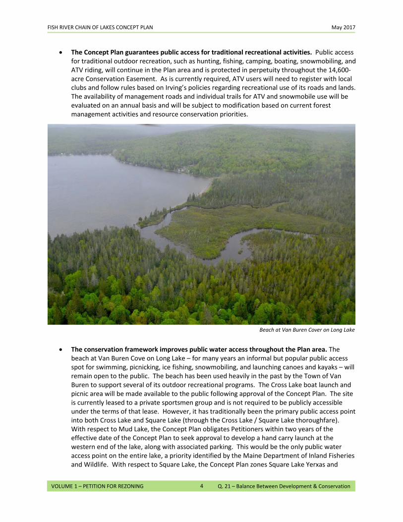
FISH RIVER CHAIN OF LAKES CONCEPT PLAN May 2017
4
Q. 21 – Balance Between Development & Conservation VOLUME 1 – PETITION FOR REZONING
• The Concept Plan guarantees public access for traditional recreational activities. Public access for traditional outdoor recreation, such as hunting, fishing, camping, boating, snowmobiling, and ATV riding, will continue in the Plan area and is protected in perpetuity throughout the 14,600-acre Conservation Easement. As is currently required, ATV users will need to register with local clubs and follow rules based on Irving’s policies regarding recreational use of its roads and lands. The availability of management roads and individual trails for ATV and snowmobile use will be evaluated on an annual basis and will be subject to modification based on current forest management activities and resource conservation priorities.
• The conservation framework improves public water access throughout the Plan area. The
beach at Van Buren Cove on Long Lake – for many years an informal but popular public access spot for swimming, picnicking, ice fishing, snowmobiling, and launching canoes and kayaks – will remain open to the public. The beach has been used heavily in the past by the Town of Van Buren to support several of its outdoor recreational programs. The Cross Lake boat launch and picnic area will be made available to the public following approval of the Concept Plan. The site is currently leased to a private sportsmen group and is not required to be publicly accessible under the terms of that lease. However, it has traditionally been the primary public access point into both Cross Lake and Square Lake (through the Cross Lake / Square Lake thoroughfare). With respect to Mud Lake, the Concept Plan obligates Petitioners within two years of the effective date of the Concept Plan to seek approval to develop a hand carry launch at the western end of the lake, along with associated parking. This would be the only public water access point on the entire lake, a priority identified by the Maine Department of Inland Fisheries and Wildlife. With respect to Square Lake, the Concept Plan zones Square Lake Yerxas and
Beach at Van Buren Cover on Long Lake
FISH RIVER CHAIN OF LAKES CONCEPT PLAN May 2017
5
Q. 21 – Balance Between Development & Conservation VOLUME 1 – PETITION FOR REZONING
Square Lake E to allow development of up to three water access sites between them. Only one of these sites may be a trailered ramp, which must be made available to the public.
• The conservation framework maintains the working forest. The vast majority of the more than 51,000-acre Plan area will be protected for working forest uses through M-FRL-GN zoning. In addition, the approximately 14,600 acres of land within the Conservation Easement preserves the working forest in perpetuity. All harvesting in the Plan area will be subject to sustainable forestry practices, which will include a management plan (prepared in consultation with the Conservation Easement holder for those areas within the Conservation Easement) that will be reviewed every five years. Nearly all types of residential, commercial, and industrial development, including particularly the kind of unplanned growth that would otherwise be permissible under current rules, are prohibited in the M-FRL-GN zone. These limited uses are also reflected in the Conservation Easement. This will preserve the land’s economic value as a commercial working forest while maintaining its character as a haven for recreational use and protecting the wealth of natural resources. Most development that is allowed under the Conservation Easement will subject to oversight from the easement holder to assure that it is consistent with the conservation values of the Conservation Easement. This is particularly significant along Square Lake, which could otherwise face secondary development pressure due to waiver of the adjacency principle for Square Lake Yerxas and Square Lake E. The Conservation Easement also protects other areas of Square and Cross Lakes, which could become prime targets for future shoreline development.
22. Conservation Measures: If conservation easements are proposed, describe their substantive provisions (e.g. area of easement, allowed uses, access, special restrictions). Describe how the proposed easement holder meets the Commission’s Guidelines for Selection of Easement Holders. If alternative conservation measures are proposed, describe their substantive provisions and describe how these measures fully provide for long-term protection or conservation.
The Concept Plan includes a robust 14,600-acre Conservation Easement that will provide substantial public benefits, comparable conservation, and mitigation through permanent conservation, preservation of public access, and promoting the working forest while substantially restricting allowable development. The Conservation Easement was specifically designed to preserve large, unfragmented forest blocks using boundaries that will be readily identifiable in the field to maximize its ecological value and to improve the ability of the easement holder to monitor the protected area. The Conservation Easement establishes key conservation values, such as promoting a healthy, diverse forest; protecting aquatic resources, wildlife, plant, and natural communities; and ensuring maintenance of public access for recreation; and prohibits activities that adversely affect those values. See Volume 2 at Tab 3(A) for a draft of the Conservation Easement. Overall, the ratio of permanently conserved shoreline to new development areas on the shoreline is 6.5:1 when including both lakes and thoroughfares. This is consistent with multiple past concept plans approved by LUPC and is an essential element of preserving the character and ecological values of the Fish River Chain of Lakes. Conservation Easement Provisions Below is a summary of key provisions of the proposed Conservation Easement. In total, these provisions ensure permanent protection of high-value, at-risk areas from threats of future development, permanently protect valuable natural resources, and guarantee public access for recreation throughout the Plan area.
• Permanently Preserves Natural and Undeveloped Shorelines. The 14,600-acre Conservation Easement Area conserves approximately 17 miles of shoreline on lakes and thoroughfares, including about 10.6 miles of shoreline around Square Lake, about 2.0 miles of shoreline on Cross Lake, about 1.7 miles of shoreline on Mud Lake, about 2.0 miles along the Mud/Cross Lake thoroughfare, about 0.5 miles on the south side of the Cross/Square Lake thoroughfare. As noted above, in total, the ratio of permanently protected shoreline to new development areas on the shoreline is 6.5:1.
• Permanently Preserves Habitat. The Conservation Easement permanently preserves a wealth of valuable natural habitats, all of which will be cataloged in a baseline document to be prepared by the easement holder identifying, among other things, the physical and biological condition of the property, including any special sites and resources, and scenic resources of high public value. Over 600 acres of the Cross Lake Fen and all of the Cross Lake Bog (roughly 3,000 acres) will be protected in perpetuity. The areas under conservation also include eagle and osprey nests, DWAs, wetlands, vernal pools, and Inland Waterfowl and Wading Bird Habitat. See Volume 3, Maps 19 & 20 for more information on identified natural resources. The land also abuts Maine Public Reserve
FISH RIVER CHAIN OF LAKES CONCEPT PLAN May 2017
2
VOLUME 1 – PETITION FOR REZONING Question 22 – Conservation Measures
Land around Eagle Lake, thus amplifying its ecological benefit by connecting with another large block of unfragmented, protected forest.
• Guarantees Public Access for Outdoor Recreation.
The Conservation Easement will guarantee forever continued public access for outdoor recreation, such as hunting, fishing, camping, boating, snowmobiling, and ATV riding. ATVs and snowmobiles will be restricted to dedicated trails that have been marked for such uses. As is currently required, ATV and snowmobile users will need to register with local clubs and follow rules based on Petitioners’ policies. The availability of individual trails for ATV and snowmobile use will be evaluated on an annual basis and will be subject to modification based on factors such as ongoing forest management activities and resource conservation. The development of new and expanded trail systems, as well as limited numbers of remote rental cabins and remote campsites, throughout the Plan area is permitted as part of the Hub, Spokes, and Rim system. This will also make existing sites, such as Limestone Point, more valuable by creating an interconnected web of recreational resources.
• Maintains the Working Forest. The Conservation Easement specifically allows continued timber harvesting activities, which will promote the important economic, cultural, and historic values of the working forest. All harvesting, however, will be subject to a management plan prepared in consultation with the easement holder and reviewed every five years. In addition, all forestry activities must be subject to sustainable forestry practices.
• Limits Residential, Commercial and Industrial Development. Development within in the Easement Area will be limited to the specific activities delineated in
the Conservation Easement. Most development activities, including residential, commercial, industrial, and institutional uses, are prohibited. This will preserve the land’s economic value as a commercial working forest while maintaining its character as a haven for recreational use. The Conservation Easement prohibits all uses that are not specifically authorized, and thus precludes in perpetuity nearly all types of residential, commercial, and industrial development, including particularly the kind of haphazard, incremental growth that would otherwise be permitted under LUPC’s current rules. Most development that is allowed under the Conservation Easement will require consent from the easement holder that such development is consistent with the conservation values of the Conservation Easement. This is particularly valuable along Square Lake, which could otherwise face secondary development pressure due to waiver of the adjacency principle for Square Lake Yerxas and Square Lake E, but also along other areas of Square and Cross Lakes, which are prime targets for future shoreline development.
Easement Holder Qualifications The Petitioners anticipate that the Conservation Easement will be held by the Forest Society of Maine (FSM). FSM is a non-profit, state-wide land trust focused on Maine’s North Woods that has helped to pioneer landscape-scale conservation through the development and implementation of conservation easements to sustain the ecological, economic, cultural, and recreational values of Maine’s forests. Its mission is to conserve Maine’s forestlands to sustain their ecological, economic, cultural, and recreational values. FSM attained national accreditation in 2009, which was renewed in 2014. It
FISH RIVER CHAIN OF LAKES CONCEPT PLAN May 2017
3
VOLUME 1 – PETITION FOR REZONING Question 22 – Conservation Measures
currently oversees easements on more than one million acres of forestlands, and, when measured by the number of acres conserved, is in the top five of land trusts in the country. FSM, therefore, clearly meets the legal requirements to hold conservation easements in 33 M.R.S. § 476(2). In addition, the selection of FSM is consistent with LUPC’s Guidelines for Selection of Conservation Easement Holders, including having compatible conservation goals, adequate financial resources, and a commitment to monitoring. FSM was previously approved by LUPC as the holder of the conservation easement associated with the Moosehead Lake Region Concept Plan, the most recent concept plan approved in the UT. The Moosehead Lake conservation easement covers 359,000 acres, which is the second largest conservation easement in the country (and by far the largest conservation easement ever granted in association with a concept plan). FSM has conservation easements on lands in relatively close proximity to the Fish River Chain of Lakes, including at the Violette Brook Reservoir (350 acres, in Cyr Plantation), Tearmunn Hardwoods (1,700 acres, in the Town of Van Buren and Cyr Plantation), and, recently, the Reed Forest land (32,400 acres, in Reed Plantation). Please see Exhibit G in Volume 1 for more information on the qualifications of FSM to hold the Conservation Easement. Monitoring and enforcement of the terms of the Conservation Easement will be conducted by FSM. The Petitioners will pay for a monitoring and enforcement fund to support these activities, both with an up-front initial contribution and then with additional contributions for each division of the protected property, in accordance with the Conservation Easement.


![HARRIS MANAGEMENT, INC., et al. PAUL COULOMBE et al ... · HARRIS MANAGEMENT, INC., et al. v. PAUL COULOMBE et al. SAUFLEY, C.J. [¶1] Paul Coulombe and two LLCs under his control—PGC1,](https://img.pdfslide.us/doc/110x75/5e6f43e238c2182f4e50a8b7/harris-management-inc-et-al-paul-coulombe-et-al-harris-management-inc.jpg)