Embed Size (px)
Citation preview
Timber Pricing Branch Reporting
5-1 Amendment No. 25 August 1, 2016
Field Procedures 5
This manual chapter assumes the waste surveyor is knowledgeable in the principles of
sampling and surveying and is familiar with log scaling and grading procedures.
If there are uncertainties over any aspect of the field procedures, waste surveyors are
encouraged to direct questions to the district, regional or branch staff.
Provincial Logging Residue & Waste Measurement Procedures Manual FLNRO
December 13, 2016 Amendment No. 26 5-2
5.1 General Requirements
5.1.1 Material to be Measured
5.1.1.1 Pre Harvest Waste Assessment (PHWA)
PHWA samples at Secondary Manufacturing Facility (SMF) must be measured in
accordance the Scaling Manual. All pieces must be measured and recorded as grades 1, 2,
4, 5, 6, and Z pieces.
Note: For informational purposes only the use of grade code 5 has been reintroduced for
the interior PHWA process only, as a waste measurement attribute to enable the reporting
of dry grade 4 timber. Grade code 5 is not used as a standard scale grade code. Grade 5
logs are identified as per Section 5.8.3.
5.1.1.2 Plot Surveys
All waste volumes within the plot boundaries must be measured and recorded according
to the Timber Merchantability Specifications specified in this manual.
For pieces that lie across the plot boundary, record the in-plot portion only but classify
(kind, waste class, grade) based on the entire piece as if it were completely within the
plot.
All coniferous and deciduous timber except reserved timber which is within the
specifications of Timber Merchantability described in this manual must be measured and
recorded.
5.1.1.3 Road Deactivation Material
Road deactivation material is timber previously used in the construction of a culvert,
bridge or a right-of-way which has since been deactivated.
At the time of a waste assessment, all road deactivated material that has not been
previously scaled must be included in the waste assessment. All road material must be
one hundred percent measured unless it is unsafe, then the volume may be estimated
using an accepted method.
Dry grade 4 Dead and dry lumber reject that is not measured in
waste. If using the PHWA SFP process then dry
grade 4 is recoded as grade 5.
Timber Pricing Branch Reporting
5-3 Amendment No. 25 August 1, 2016
5.1.1.4 Decked Timber
Decked timber is five or more logs that are mechanically placed together in a deck.
If a forest officer determines that a log deck is to be scaled at a scale site or field scaled,
the log deck must be clearly marked and identified by the licensee in order that the timber
in the log deck will not be included in the waste assessment.
For decked timber that is to be included in a waste assessment, the logs must be 100 %
measured or estimated using the most practical method as determined by the licensed
surveyor such as top scale or average piece size times number of pieces.
5.1.2 Recording Standards
To measure waste material, follow the rules in the Ministry of Forests, Lands and Natural
Resource Operations Scaling Manual except where otherwise described in this manual.
Record the (inside bark) gross dimensions of each piece including rot or other defects. In
addition, the waste surveyor calculates the volume deductions for any defects and records
the deduction equivalent under "Deduction for Rot/Holes" in rads and/or metres, along
with the most appropriate "decay type."
When netting-down the dimensions of a log because of defect, the gross length will be
used to determine if the piece meets the 3 m minimum log length. Therefore, the net
length of a log used for volume calculations can be less than 3 m.
Record gross length measurements to the nearest one-tenth (0.1) of a metre and gross
diameter measurements in radius class units (rads, 1 rad = 2 cm). Record deductions in
length to the nearest one-tenth (0.1) of a metre and deductions in radius to the nearest rad.
Top measurements on logs which have very little taper must be made carefully, due to the
length of merchantable wood involved between radius classes. For oversized tops, the
measurement is to be made at the last occurrence (i.e., uppermost on the tree) of the
applicable timber merchantability top dimension specification. When using a scale stick,
for a 10 cm top, it will be the mid-point of the 5 radius class. For a 15 cm top, it will be
the line separating the 7 and the 8 radius class. All measurements are inside bark.
The measurement of the portion of borderline pieces outside the plot may be recorded but
are not mandatory. The minimum requirement will be the measurements of the portions
of the pieces within the plot, together with a code (when needed) that will override
computer checks on minimum log length.
Detailed measurement protocol and standards are included later in this chapter.
Provincial Logging Residue & Waste Measurement Procedures Manual FLNRO
December 13, 2016 Amendment No. 26 5-4
5.1.3 PHWA Standards
Material measured under the PHWA process must be scaled in accordance with the
Scaling Manual with the following exception, grade code 5 is used to describe dry grade 4
timber.
5.1.4 Waste Class
Waste classification must not be biased for any reason such as accommodating
inadequate planning and supervision, poor harvesting methods, inadequate/careless
logging practices or a licensee's own manufacturing or market specifications.
All waste must be classified as either avoidable or unavoidable.
By definition, all other volumes are avoidable.
5.1.4.1 Some Unavoidable Examples
1. Due to physical impediments:
a. logs wedged between boulders, or
b. a log stranded on a ledge.
2. Due to safety:
a. the portion of a high stump (with a rock against it) between the maximum
allowable stump height and the height where the stump could have been safely cut
(Figure 5.4),
b. logs with shards of imbedded rock from blasting (Section 5.3.10),
c. log pieces that were cut to create escape paths for the fallers (Section 5.3.4.2),
d. bucking waste with severe deformities as outlined in Figure 5.3.5.1, or
e. logs that are unsafe to remove due to site specific circumstances.
3. Due to environmental constraint:
a. a log if removed will cause excessive site disturbance or soil degradations, or
b. approved high stumps due to snowpack (Section 5.3.4.4),
c. stub trees to be used for biodiversity purposes.
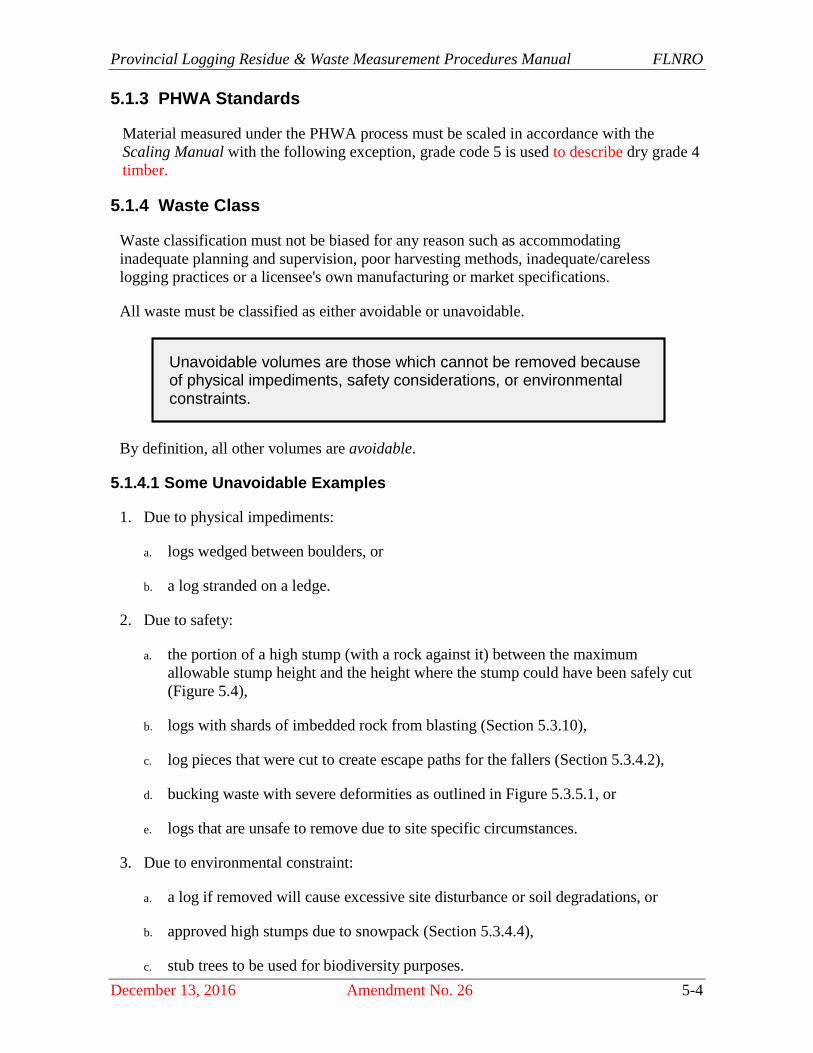
Unavoidable volumes are those which cannot be removed because of physical impediments, safety considerations, or environmental constraints.
Timber Pricing Branch Reporting
5-5 Amendment No. 25 August 1, 2016
5.1.4.2 Piece Numbers
Waste pieces are usually recorded with one set of measurements.
However, where high stumps or forks are found, the piece may have both avoidable and
unavoidable segments.
In these situations, the segments are recorded separately, each with its own piece number.
Record MP on the comment column of FS 161 to indicate multiple pieces. Mark all
pieces measured in the plot clearly with the piece number, using tree marking paint.
5.1.5 Grading Pieces
Log pieces must be graded according to the rules in the Scaling Manual except where the
waste rules are different and then waste rules are used.
For example the minimum log length for waste is 3 m instead of the 2.5 m in the Scaling
Manual.
For more information on the grading rules see the Scaling Manual.
On the coast, due to the timber pricing changes made to Hemlock, Balsam U and X
grades for all coniferous species, refer to Appendix 6 on how to grade bucking waste,
stumps, logs and standing trees.
When the waste assessment of a cutblock has not been conducted within the allowable
time frame, log pieces must be graded according to their conditions (i.e., grade and
decay) at the time the waste survey should have been conducted.
5.1.6 Visual Estimates
If loose debris cannot be quickly moved away to facilitate measurements in dispersed
plots, or if logs and/or branches in landings prevent measuring one of the ends or the
length of a log, visually estimate the missing dimension. In order to correctly establish
the grade, at least one end must be visible or the piece should not be recorded.
5.1.7 Measure Factor
In deep accumulations, it may not be possible to measure or visually estimate each piece.
In these cases, first measure and/or visually estimate the material that is accessible.
Then, project the plot boundaries down to the ground and visually estimate what portion
of the volumes within the plot boundaries were measured. Record this portion on the plot
tally card under "measure %."
This percent is known as the "Measure Factor", and is only applied to the plot method.
Measure as many pieces as possible, even when some dimensions of an individual piece
must be estimated.

Provincial Logging Residue & Waste Measurement Procedures Manual FLNRO
August 1, 2016 Amendment No. 25 5-6
In the example below: If you were able to measure down approximately 2 m, you would
record a measure factor of 40 percent providing that the volumes of waste were spread
evenly through the cylinder within the plot boundaries. The measure factor is derived
from 2m/5m x 100% = 40%.
Figure 5-1 Measure Factor.
5.1.8 Deductions for Rot
For material containing rot, measure and record the gross dimensions of the piece (actual
size) including rot. In addition, surveyor calculates the volume deduction for rot but
records the deduction equivalent in rads and/or metres, along with the most appropriate
"decay type".
5.1.9 Waste Survey Safety Procedures
In accordance with Section 3.12(1) of the Occupational Health and Safety Regulation -
“A person must not carry out or cause to be carried out any work process or operate or
cause to be operated any tool, appliance or equipment if that person has reasonable cause
to believe that to do so would create an undue hazard to the health and safety of any
person.”
The objective of this section is to provide an alternative method of determining waste
volumes where a portion or the entire plot or block cannot be measured safely.
1. Where a piece or portion of a plot or an entire plot cannot be measured safely, attempt
to complete the piece or plot through estimation from a nearby location.
2. Where the plot cannot be measured or estimated safely, move the plot to a safe
location as specified in Section 5.2.3 up to a maximum of 48 meters. If there is no
safe location within 48m, drop the plot.
3. When a plot must be dropped for safety, use replacement data of an existing plot from
the same cut block or license that has similar waste levels, species and grade profile,
age and method of harvesting. The surveyor may have to use a measure factor to
adjust the volume to make it representative of the actual waste levels.
Timber Pricing Branch Reporting
5-7 Amendment No. 25 August 1, 2016
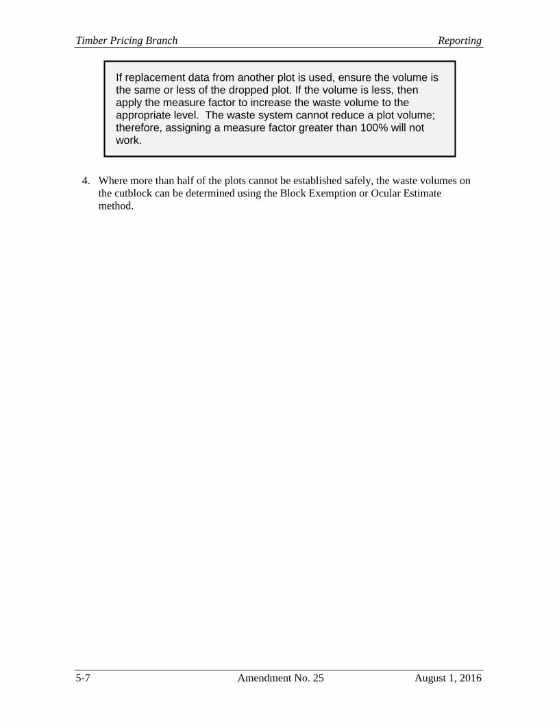
4. Where more than half of the plots cannot be established safely, the waste volumes on
the cutblock can be determined using the Block Exemption or Ocular Estimate
method.
If replacement data from another plot is used, ensure the volume is the same or less of the dropped plot. If the volume is less, then apply the measure factor to increase the waste volume to the appropriate level. The waste system cannot reduce a plot volume; therefore, assigning a measure factor greater than 100% will not work.
November 1, 2009 Amendment No. 13 5-8
5.2 Plot Establishment
All P.O.Cs and tie points should be marked with aluminum tags and either flagging
ribbon or high-visibility paint and be easily observed from access roads.
Plot centres are to be marked with a sturdy stake driven well into the ground and made
clearly visible with paint or surveyors flagging ribbon and identified with waterproof felt
pen or aluminum tags.
Plot boundaries are to be clearly marked on all borderline pieces with paint.
Plot boundaries are to be measured from the point where the plot stake enters the ground.
Recorded pieces are to be clearly numbered with tree marking paint.
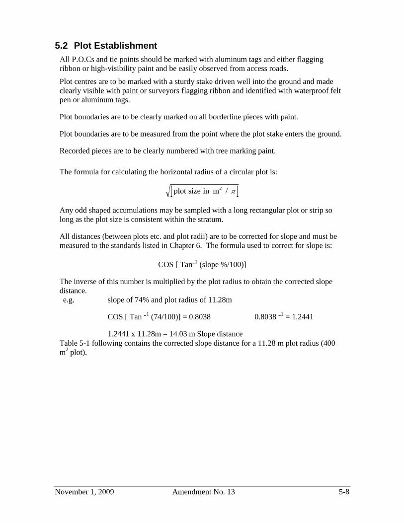
The formula for calculating the horizontal radius of a circular plot is:
Any odd shaped accumulations may be sampled with a long rectangular plot or strip so
long as the plot size is consistent within the stratum.
All distances (between plots etc. and plot radii) are to be corrected for slope and must be
measured to the standards listed in Chapter 6. The formula used to correct for slope is:
COS [ Tan-1 (slope %/100)]
The inverse of this number is multiplied by the plot radius to obtain the corrected slope
distance.
e.g. slope of 74% and plot radius of 11.28m
COS [ Tan -1
(74/100)] = 0.8038 0.8038 -1
= 1.2441
1.2441 x 11.28m = 14.03 m Slope distance
Table 5-1 following contains the corrected slope distance for a 11.28 m plot radius (400
m2
plot).
plot size in m2
/
Timber Pricing Branch Reporting
5-9 Amendment No. 13 November 1, 2009
Table 5-1 Slope Distances for 11.28 m Plot Radius
5% - 11.29 m 39% - 12.11 m 73% - 13.97 m
6% - 11.30 m 40% - 12.15 m 74% - 14.03 m
7% - 11.31 m 41% - 12.19 m 75% - 14.10 m
8% - 11.32 m 42% - 12.23 m 76% - 14.17 m
9% - 11.33 m 43% - 12.28 m 77% - 14.24 m
10% - 11.34 m 44% - 12.32 m 78% - 14.31 m
11% - 11.35 m 45% - 12.37 m 79% - 14.38 m
12% - 11.36 m 46% - 12.42 m 80% - 14.45 m
13% - 11.38 m 47% - 12.46 m 81% - 14.52 m
14% - 11.39 m 48% - 12.51 m 82% - 14.59 m
15% - 11.41 m 49% - 12.56 m 83% - 14.66 m
16% - 11.42 m 50% - 12.61 m 84% - 14.73 m
17% - 11.44 m 51% - 12.66 m 85% - 14.80 m
18% - 11.46 m 52% - 12.71 m 86% - 14.88 m
19% - 11.48 m 53% - 12.77 m 87% - 14.95 m
20% - 11.50 m 54% - 12.82 m 88% - 15.03 m
21% - 11.53 m 55% - 12.87 m 89% - 15.10 m
22% - 11.55 m 56% - 12.93 m 90% - 15.18 m
23% - 11.58 m 57% - 12.98 m 91% - 15.25 m
24% - 11.60 m 58% - 13.04 m 92% - 15.33 m
25% - 11.63 m 59% - 13.10 m 93% - 15.40 m
26% - 11.66 m 60% - 13.16 m 94% - 15.49 m
27% - 11.68 m 61% - 13.21 m 95% - 15.56 m
28% - 11.71 m 62% - 13.27 m 96% - 15.64 m
29% - 11.75 m 63% - 13.33 m 97% - 15.71 m
30% - 11.78 m 64% - 13.39 m 98% - 15.79 m
31% - 11.81 m 65% - 13.45 m 99% - 15.87 m
32% - 11.84 m 66% - 13.52 m 100% - 15.95 m
33% - 11.88 m 67% - 13.58 m 110% - 16.77 m
34% - 11.91 m 68% - 13.64 m 120% - 17.62 m
35% - 11.95 m 69% - 13.71 m 130% - 18.50 m
36% - 11.99 m 70% - 13.77 m 140% - 19.40 m
37% - 12.03 m 71% - 13.83 m 150% - 20.34 m
38% - 12.07 m 72% - 13.90 m
Provincial Logging Residue & Waste Measurement Procedures Manual FLNRO
November 1, 2009 Amendment No. 13 5-10
5.2.1 Locating Landing Plots
Landing plots are located on a line starting from the geographic centre of the landing.
Mark the centre of the landing (with orange ribbon or paint) so that the check surveyor
will be able to find your P.O.C.
The first line is always run north from your P.O.C.
A plot is located at mid distance between the points where the line enters and exits the
accumulation. This distance must be at least twice the plot radius because the plot must
fall completely within the accumulation.
If a circular plot cannot be established on the North bearing, try East, then South, then
West. If a circular plot cannot be established on these bearings try N45E, S45E, S45W
and N45W consecutively. If a circular plot still cannot be established try N22.5E,
N67.5E, S67.5E, S22.5E, S22.5W, S67.5W, N67.5W and N22.5W consecutively around
the compass.
If a circular plot still cannot be established using the smallest plot size available (50m2
- 3.99 m radius) then a rectangular plot can be established or 100 percent of the pile
measured.
In blocks where there is only one landing or one landing that is safe to work on the
minimum of two plots must still be established so a landing may have to have more than
one plot established on it. In this case distribute the plots as evenly as possible over the
accumulation(s).
5.2.2 Locating Dispersed Plots
Dispersed plots are to be located on a systematic staggered grid as per the Block Survey
Plan drawn up for the block. See Plot Layout-Dispersed in Section 4.4.1.
5.2.3 Moving Dispersed Plots
5.2.3.1 Using Border Plots
If the dispersed plot centre falls within the stratum to be sampled but a 400 m2
circular
plot cannot be established because part of the plot falls outside the stratum, establish a
400 m2
half circular plot (15.96 m radius).
This procedure is auditable so the plot must be established at the first successful attempt using the sequence of steps listed above.
Timber Pricing Branch Reporting
5-11 Amendment No. 13 November 1, 2009
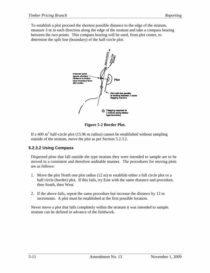
To establish a plot proceed the shortest possible distance to the edge of the stratum,
measure 3 m in each direction along the edge of the stratum and take a compass bearing
between the two points. This compass bearing will be used, from plot centre, to
determine the split line (boundary) of the half-circle plot.
Figure 5-2 Border Plot.
If a 400 m2
half-circle plot (15.96 m radius) cannot be established without sampling
outside of the stratum, move the plot as per Section 5.2.3.2.
5.2.3.2 Using Compass
Dispersed plots that fall outside the type stratum they were intended to sample are to be
moved in a consistent and therefore auditable manner. The procedures for moving plots
are as follows:
1. Move the plot North one plot radius (12 m) to establish either a full circle plot or a
half circle (border) plot. If this fails, try East with the same distance and procedure,
then South, then West.
2. If the above fails, repeat the same procedure but increase the distance by 12 m
increments. A plot must be established at the first possible location.
Never move a plot that falls completely within the stratum it was intended to sample.
stratum can be defined in advance of the fieldwork.
Provincial Logging Residue & Waste Measurement Procedures Manual FLNRO
November 1, 2009 Amendment No. 13 5-12
For example, roadside accumulations are often defined as 10 m wide and along both sides
of the roads throughout the entire block.
If a large volume has slid down a steep slope from a roadside accumulation and a
dispersed plot lands on the pile, that is where it must stay so long as the outside edge of
the dispersed plot does not fall within the predetermined width of the roadside
accumulation. Again, unless that pile were previously delineated and removed from the
dispersed area, it is part of the dispersed sub-population.
Gravel pits and large swamps should be typed out and plots which fall on these locations
must be moved to a spot within a type stratum.
Therefore, typing is very important to obtain reliable estimates.
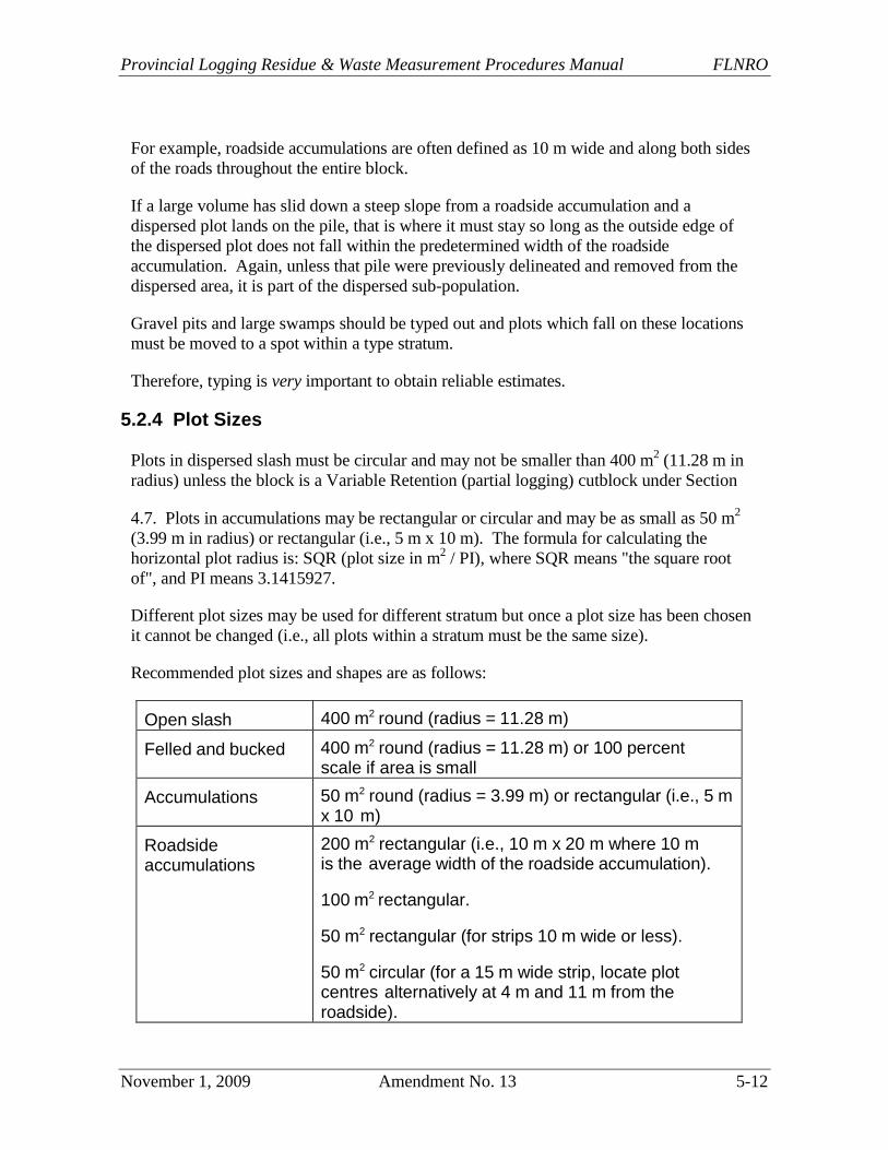
5.2.4 Plot Sizes
Plots in dispersed slash must be circular and may not be smaller than 400 m2
(11.28 m in
radius) unless the block is a Variable Retention (partial logging) cutblock under Section
4.7. Plots in accumulations may be rectangular or circular and may be as small as 50 m2
(3.99 m in radius) or rectangular (i.e., 5 m x 10 m). The formula for calculating the
horizontal plot radius is: SQR (plot size in m2
/ PI), where SQR means "the square root
of", and PI means 3.1415927.
Different plot sizes may be used for different stratum but once a plot size has been chosen
it cannot be changed (i.e., all plots within a stratum must be the same size).
Recommended plot sizes and shapes are as follows:
Open slash 400 m2 round (radius = 11.28 m)
Felled and bucked 400 m2 round (radius = 11.28 m) or 100 percent scale if area is small
Accumulations 50 m2 round (radius = 3.99 m) or rectangular (i.e., 5 m x 10 m)
Roadside accumulations
200 m2 rectangular (i.e., 10 m x 20 m where 10 m is the average width of the roadside accumulation).
100 m2 rectangular.
50 m2 rectangular (for strips 10 m wide or less).
50 m2 circular (for a 15 m wide strip, locate plot centres alternatively at 4 m and 11 m from the roadside).
Timber Pricing Branch Reporting
5-13 Amendment No. 13 November 1, 2009
For fixed width roadside stratums that are over 15 m wide, rectangular plots must be used
and the minimum acceptable size is 50 m2. Each plot must cover half the width of the
stratum by the distance required to make the plot size. The plots will be staggered with
the odd number plots covering the outside half of the stratum and the even number of
plots covering the inside half (i.e., for a 20 m wide stratum each plot would be 10 m wide
by 5 m long). Alternatively, 100 m2
rectangular plots covering the entire width of the
stratum are acceptable.
For varying width stratums, map the width of the stratum every 25 m along the road.
Rectangular plots (which cover the entire width of the stratum where the plot is located)
must be used. The minimum acceptable plot size is 100 m2
unless the maximum width of
the stratum is 10 m or less and then 50 m2
plots are acceptable (i.e., for a 18 m wide
stratum use an 18 m by 5.56 m plot).
Provincial Logging Residue & Waste Measurement Procedures Manual FLNRO
August 1, 2016 Amendment No. 25 5-14
5.3 Kind of Material
5.3.1 Logs
A log is defined as any near-round piece with more than half of its original
circumference remaining and with an average diameter equal to or larger than the timber
merchantability specification diameter for at least 3 m of length.
Logs are measured in accordance with the Scaling Manual and Scaling Regulation, with
some exceptions, as specified in this manual.
Measure the diameter to the nearest radius class unit on the scale stick (1 rad = 2 cm) and
measure the length to the nearest 0.1 m (i.e., nearest decimetre).
"Log length" is the length that a scaler records to accurately determine the gross volume
of the piece; i.e., without making any deductions for rot.
A broken top piece is measured from the top contractual diameter, and then a length
deduction (from the diameter to the XY line) is applied to account for the missing wood,
as illustrated in Section 5.5.1.1 (Figure 5.10).
In a waste survey, the term "logs" encompasses all down logs, slabs, that are a minimum
of 3 m in length with a top diameter of 10 cm or 15 cm. Record as "L" under "Kind of
Material" on the plot survey card (FS 161).
5.3.2 Trees
Trees left standing after timber harvesting that are not reserved for silviculture,
biodiversity or a forest management reason are measured in a waste assessment and
classified as avoidable or unavoidable waste.
Appropriate documents such as tenure licence documents, timber appraisal applications
and maps need to be referenced to determine the conifer and/or deciduous leave trees
identified by species to be retained as reserved timber for the cutblock being waste
assessed. These specifications apply to trees outside of the mapped wildlife tree patches.
5.3.2.1 Clearcut
Individual standing tree volumes that are measured must be kept separate from the plot
waste volumes. Standing tree dimensions are recorded using FS 161, Waste Survey Plot
Tally. Trees that were left scattered sparingly throughout the cutblock are measured
individually and each tree is numbered and marked with paint. Record the timber
merchantability specification top diameter in rads as the top diameter. The length is
determined using a tape/chain and a clinometer or an electronic measuring device such as
a laser instrument. The waste surveyor visually estimates the location of the top diameter
and then measures the length from this point down to the timber merchantability stump
height (must make a 3 m log that meets the timber merchantability specifications). If the
top is broken, the waste surveyor visually estimates the diameter at the break, and
measures the length from the break mid-point to the stump height. The butt diameter is
Timber Pricing Branch Reporting
5-15 Amendment No. 25 August 1, 2016
obtained by measuring the tree diameter at the timber merchantability specification stump
height, accounting for flare.
On the FS 161, under Kind, record T for standing trees or D for downed trees, classify the
trees as avoidable or unavoidable. Enter the dimensions for length, top and butt
diameters, end codes, and assign a log grade.
One possible method for determining the volume of standing trees is to record the species
and diameter of each tree and use the Extended Type Stand and Stock Table from the
timber cruise compilation.
For trees that were left in a large patch where individual tree measurement is impractical,
the waste surveyor will perform a closed traverse measuring the precise area represented
by the tree patch. The cruise net volume per hectare (for that timber type(s)) will be used
to determine the volume of timber in the tree patch that was not harvested. A patch is
defined to be a grouping of trees occupying an area of more than one hectare. For a patch
that is less than one hectare, a surveyor may apply the cruise net average or opt for
individual tree measurement.
For scattered standing trees, the standing tree areas must be properly stratified. Plots will
be allowed but the block must be surveyed using the Cutblock option.
Except for individual standing or downed trees where each tree is individually graded, the
grade allocations for large tree patches left in clearcuts, are based on the historic billing
grade profile of the timber mark for the cutting authority. Only in the absence of the
billing history records or if an RPF or RFT considers the historical records are
unrepresentative of the grade profile on site, grades may be derived by an RPF or RFT
based on examinations of the actual grade compositions of the stand left on site.
5.3.2.2 Partial Cut
Surveyors should reference appropriate documents that provide the volume percent
reduction by either one or more of species, timber type, risk group/tree class or treatment
unit for each individual cutblock within the cutting permit or agreement.
Timber volume that is left in excess of the leave volume will be billed as waste subject to
the application of the waste benchmarks.
There are at least two methods - recruise, fixed area waste plots, for determining the
unharvested standing tree volume in a partial cut. Choose a method that is appropriate
for the cutblock.
For a recruise, a licensee must strive to put in a sufficient number of cruise plots that will
either meet or exceed the sampling error achieved in the original cruise.
If waste plots are used, the plot size should be 400 m2. A licensee must strive to put in a
sufficient number of waste plots that will meet or exceed the sampling error objective
approved for the reporting unit. The minimum sampling intensity required is at least two
plots per stratum or if the cutblock is not stratified, two plots per cutblock.
Provincial Logging Residue & Waste Measurement Procedures Manual FLNRO
August 1, 2016 Amendment No. 25 5-16
Once the unharvested standing tree volume has been derived, the timber scale grades will
be assigned using the historic billing grade profile of the timber mark for the cutting
authority. Only in the absence of the billing history records or if an RPF or RFT
considers the records are unrepresentative, grades may be derived by an RPF or RFT on
the basis of actual grade compositions of the stand left on site.
The survey results for cutblocks that have been harvested using partial cut systems must
be sponsored by an RPF or RFT. This is to confirm that the partial cut timber harvesting
requirements that were previously stated in Schedule B, or the Percent Reduction Report
in the Appraisal Cruise Compilation Submission have been met and there are no waste
billing concerns on the remaining standing tree volumes. If a field or office review by
ministry staff identifies an apparent discrepancy with the species or volume harvested,
the licensee or the TSM may be directed by the District Manager to recruise or resurvey
the residual standing trees.
5.3.2.3 Unharvested Cutblocks
The District Manager may bill an unharvested cutblock in an expired, surrendered or
cancelled cutting permit or authority. The billings will be made on the basis of the net
cruise volume attributed to the unharvested cutblock.
Once the net cruise volume is determined, the grade allocations will be based on the
historic billing grade profile of the timber mark for the cutting authority. Only in the
absence of the billing history records or if an RPF or RFT considers the records are
unrepresentative, grades may be derived by an RPF or RFT based on examinations of the
actual grade compositions of the stand left on site.
5.3.2.4 Tabular Stumpage Rates
1. This section only applies to cutblocks where primary logging is completed on or after
November 1, 2009.
2. Subject to subsection (3) of this section, and notwithstanding sections 5.3.2, 5.3.2.1
and 5.3.2.2 of this manual, where a stumpage rate for a cutting authority must be
determined under Section 6.1.1, or Section 6.1.2 of the Interior Appraisal Manual, or
Section 7.2 of the Coast Appraisal Manual, timber left standing on the cutting
authority area after primary logging has been completed will not be measured nor
billed as waste.
3. Where the District Manager determines that the holder of the agreement failed to
harvest the standing timber in accordance with:
a. the results or strategies of a Forest Stewardship Plan, or the default or alternative
performance requirements that pertain to the agreement, or
b. the results, strategies, or the measures of a Woodlot Licence Plan that pertain to
the agreement,
Timber Pricing Branch Reporting
5-17 Amendment No. 25 August 1, 2016
the District Manager may require the holder of the cutting authority to conduct a
waste assessment of the standing timber and will bill this residual timber on the
cutting authority area as avoidable waste.
4. Subsections (2) and (3) apply to standing timber only, a waste assessment of the
dispersed and accumulated subpopulations of the cutblock must be conducted as per
this manual requirements.
5.3.3 Slabs
A slab is defined as any non-round piece with less than half (1/2) of its original
circumference remaining, a minimum thickness of 10 cm and an average diameter equal
to or larger than the timber merchantability specification diameter. The only exception is
mature red cedar (on the Coast only) which must have a minimum thickness of 15 cm to
be measured or recorded.
Slabs are measured, graded and recorded as a “Log” (L) if they have a minimum
thickness of at least 10 cm for at least 3 m in length or as “Bucking Waste” (W) if they
are bucked at the butt end or both ends and have a minimum thickness of a least 10 cm
for less than 3 m but at least a tenth (0.1) of a metre.
Provincial Logging Residue & Waste Measurement Procedures Manual FLNRO
November 1, 2009 Amendment No. 13 5-18
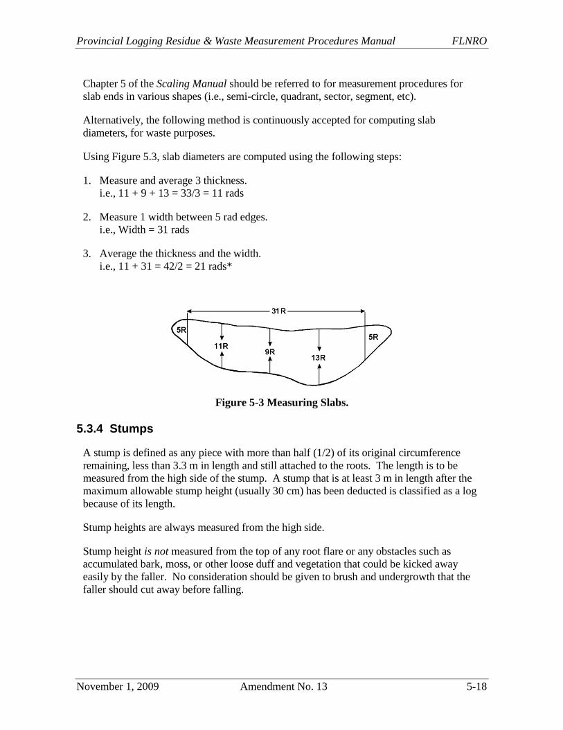
Chapter 5 of the Scaling Manual should be referred to for measurement procedures for
slab ends in various shapes (i.e., semi-circle, quadrant, sector, segment, etc).
Alternatively, the following method is continuously accepted for computing slab
diameters, for waste purposes.
Using Figure 5.3, slab diameters are computed using the following steps:
1. Measure and average 3 thickness.
i.e., 11 + 9 + 13 = 33/3 = 11 rads
2. Measure 1 width between 5 rad edges.
i.e., Width = 31 rads
3. Average the thickness and the width.
i.e., 11 + 31 = 42/2 = 21 rads*
Figure 5-3 Measuring Slabs.
5.3.4 Stumps
A stump is defined as any piece with more than half (1/2) of its original circumference
remaining, less than 3.3 m in length and still attached to the roots. The length is to be
measured from the high side of the stump. A stump that is at least 3 m in length after the
maximum allowable stump height (usually 30 cm) has been deducted is classified as a log
because of its length.
Stump heights are always measured from the high side.
Stump height is not measured from the top of any root flare or any obstacles such as
accumulated bark, moss, or other loose duff and vegetation that could be kicked away
easily by the faller. No consideration should be given to brush and undergrowth that the
faller should cut away before falling.
Timber Pricing Branch Reporting
5-19 Amendment No. 13 November 1, 2009
Measure from where the ground meets the base of the stem to the top of the felling cut (as
shown in Figure 5.4) to the nearest tenth (0.1) of a metre. The volume of the undercut is
included in the measured stump volume. Deduct the stump height of 0.3 m and record the
result under length on the FS 161.
If the total stump height is less than or equal to the stump height of 0.3 m measured from
the high side, then the stump does not have to be recorded.
For raised stumps where the tree has grown out of a rotten log, the stump height should
be measured from the point of germination, or the high side, whichever is higher.
Stumps will not normally be graded and will default to sawlog grade. However, if the log
from the stump is present the stump should be graded the same as the log.
If the stump has less than 50 percent firmwood volume, the stump is not recorded.
In the Interior, dead stumps will only be measured and recorded where the timber stand is
designated to be catastrophic.
On the Coast, dead stumps will not be measured nor recorded except cedar, cypress and
white pine. Use the following guidelines to differentiate between dead/live stumps:
Dead considerable crumbling sap rot and/or loose or missing bark.
Live little or no crumbling sap rot and bark not loose.
Sometimes stumps can be broken up in logging. Any stump fragments are ignored.
Conversely, any stumps with missing fragments are measured as if the fragment was still
in place.
5.3.4.1 Measuring and Recording Stumps
Careful measurement of stumps is critical because they contain high volume per unit of
length.
Measure the top diameter (inside bark) of the stump (unless the total height of the stump
exceeds 1.3 m) and record it in the "top" column.
For a stump whose total height exceeds 1.3 m, record the diameter (inside bark) at 1.3 m
above the ground on the high side of the stump. The taper of the stump should be
finished at approximately that point and recording the top diameter above 1.3 m would
end up under estimating the volume of the stump.
Stump diameter is always measured inside bark, and recorded to the nearest rad.
No entry is required in either the top or butt end code fields on the FS 161.
Provincial Logging Residue & Waste Measurement Procedures Manual FLNRO
November 1, 2009 Amendment No. 13 5-20
5.3.4.2 Waste in Stumps
Unless there are physical obstructions or safety precautions because of decayed wood,
waste in stumps is classified as avoidable waste.
Unavoidable waste occurs where excessive snow depth or an obstruction prevents cutting
the tree to the timber merchantability specifications. Where there are physical
obstructions or excessive snow depth, the lowest height that the tree could have been cut
must be established.
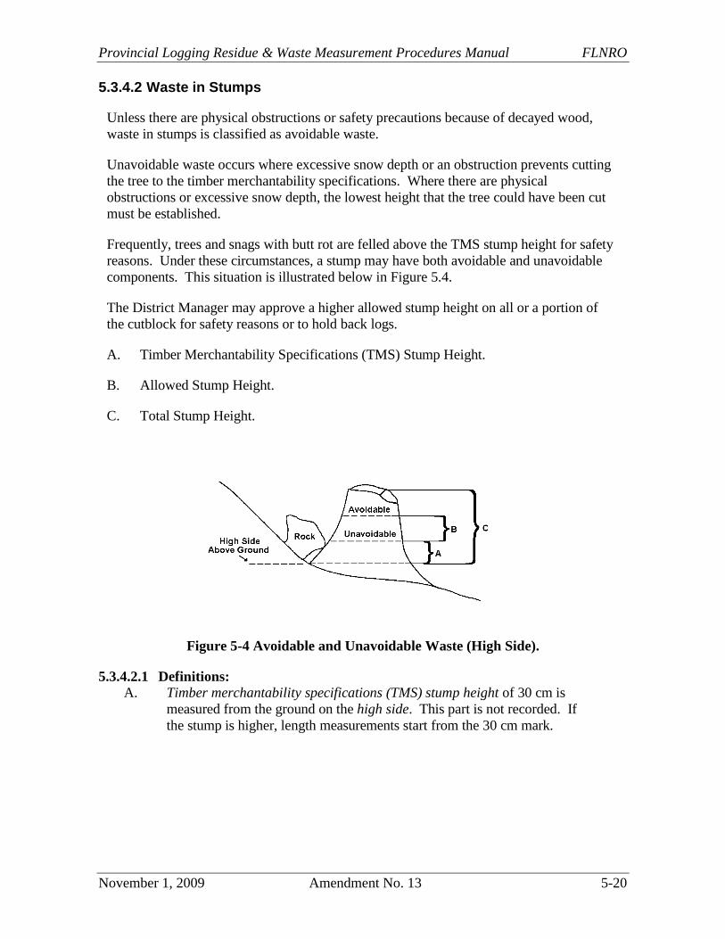
Frequently, trees and snags with butt rot are felled above the TMS stump height for safety
reasons. Under these circumstances, a stump may have both avoidable and unavoidable
components. This situation is illustrated below in Figure 5.4.
The District Manager may approve a higher allowed stump height on all or a portion of
the cutblock for safety reasons or to hold back logs.
A. Timber Merchantability Specifications (TMS) Stump Height.
B. Allowed Stump Height.
C. Total Stump Height.
Figure 5-4 Avoidable and Unavoidable Waste (High Side).
5.3.4.2.1 Definitions:
A. Timber merchantability specifications (TMS) stump height of 30 cm is
measured from the ground on the high side. This part is not recorded. If
the stump is higher, length measurements start from the 30 cm mark.
Timber Pricing Branch Reporting
5-21 Amendment No. 13 November 1, 2009
B. Allowed stump height is the height specified in the District Manager's letter
for heavy snow packs, or the minimum distance from the ground on the
high side of a stump up to a point above a physical obstruction which
allows for safe falling. B minus A = unavoidable piece.
C. Total stump height is the distance from the ground on the high side to the
top of the felling cut. C minus B = avoidable piece.
5.3.4.3 Recording Stumps in Segments
If there are both avoidable and unavoidable components of waste, the stump is recorded
as two pieces each with its own piece number and record appropriate comment code such
as MP on FS 161 to indicate multiple pieces.
Record the top portion as avoidable piece. Enter the difference between the total stump
height and the allowed stump height in the length field, and the top radius in the top field.
Classify this piece as avoidable (A).
Record the lower portion as unavoidable piece. Enter the difference between the allowed
stump height and the TMS stump height in the length field, and the top radius of this
lower segment in the top field. Classify this piece as unavoidable (U).
5.3.4.4 High Stumps - Snowpack
Winter logging can result in unavoidable waste occurring in high stumps due to
snowpack, especially alongside winter skid trails.
Where winter logging is approved and the TMS stump heights cannot be achieved by
operators because of snow conditions, the waste portion is considered avoidable unless a
written exemption is issued by the District Manager.
This exemption will specify a new maximum stump height to reflect acceptable winter
stump heights.
The portion of the stump between the TMS stump height and the allowed stump height
specified in the exemption letter is considered unavoidable.
The portion of the stump above the allowed stump height specified in the exemption
letter is considered avoidable.
In all cases, trees must be cut as close to the TMS stump height as possible.
Survey crews must confirm if an exemption letter has been issued prior to the survey.
In addition, the decision to classify stumps as unavoidable because of snow should not be
automatic. Prudent operators with a mix of operating areas are expected to avoid high
snow areas through sound planning.
Provincial Logging Residue & Waste Measurement Procedures Manual FLNRO
November 1, 2009 Amendment No. 13 5-22
5.3.4.5 Blowdown Stumps
It is very difficult to determine whether a stump on a blowdown area is avoidable or
unavoidable after the logging has been completed since there could have been a
dangerous obstruction that has since been removed.
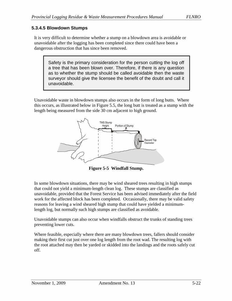
Unavoidable waste in blowdown stumps also occurs in the form of long butts. Where
this occurs, as illustrated below in Figure 5.5, the long butt is treated as a stump with the
length being measured from the side 30 cm adjacent to high ground.
Figure 5-5 Windfall Stump.
In some blowdown situations, there may be wind sheared trees resulting in high stumps
that could not yield a minimum-length clean log. These stumps are classified as
unavoidable, provided that the Forest Service has been advised immediately after the field
work for the affected block has been completed. Occasionally, there may be valid safety
reasons for leaving a wind sheared high stump that could have yielded a minimum-
length log, but normally such high stumps are classified as avoidable.
Unavoidable stumps can also occur when windfalls obstruct the trunks of standing trees
preventing lower cuts.
Where feasible, especially where there are many blowdown trees, fallers should consider
making their first cut just over one log length from the root wad. The resulting log with
the root attached may then be yarded or skidded into the landings and the roots safely cut
off.
Safety is the primary consideration for the person cutting the log off a tree that has been blown over. Therefore, if there is any question as to whether the stump should be called avoidable then the waste surveyor should give the licensee the benefit of the doubt and call it unavoidable.
Height Portion of Stump Tallied
Timber Pricing Branch Reporting
5-23 Amendment No. 13 November 1, 2009
Blowdown stumps which stand back up when the logs are bucked off should be classified
as unavoidable because they were probably cut high for safety reasons.
If bucking could safely produce a minimum length log from such stumps, the volume
above the TMS stump height should be recorded as avoidable waste.
Guy line stumps can be accepted as unavoidable if there is no unnecessary waste of
wood. Any portion that is excessive waste must be classified as avoidable. Blowdown
stumps on a landing should be classified as unavoidable.
5.3.4.6 Borderline Stumps
For borderline stumps, measure the horizontal distance from the plot centre to the
geometric centre of the stump at a point 30 cm above the high side. If this point is
located inside the plot, the entire stump is recorded. If it is not, the entire stump is not
recorded.
For knocked-over and uprooted stumps, measure the horizontal distance from the plot
centre to a point 30 cm above the high side or the point of germination (POG), whichever
is higher. If this point is located inside the plot, measure the entire stump.
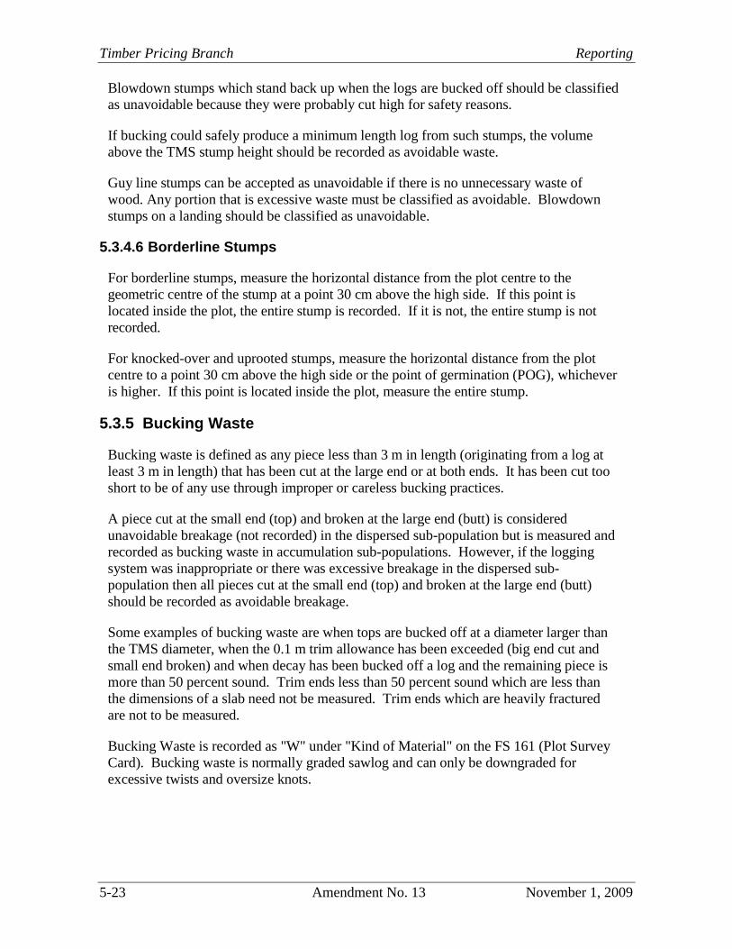
5.3.5 Bucking Waste
Bucking waste is defined as any piece less than 3 m in length (originating from a log at
least 3 m in length) that has been cut at the large end or at both ends. It has been cut too
short to be of any use through improper or careless bucking practices.
A piece cut at the small end (top) and broken at the large end (butt) is considered
unavoidable breakage (not recorded) in the dispersed sub-population but is measured and
recorded as bucking waste in accumulation sub-populations. However, if the logging
system was inappropriate or there was excessive breakage in the dispersed sub-
population then all pieces cut at the small end (top) and broken at the large end (butt)
should be recorded as avoidable breakage.
Some examples of bucking waste are when tops are bucked off at a diameter larger than
the TMS diameter, when the 0.1 m trim allowance has been exceeded (big end cut and
small end broken) and when decay has been bucked off a log and the remaining piece is
more than 50 percent sound. Trim ends less than 50 percent sound which are less than
the dimensions of a slab need not be measured. Trim ends which are heavily fractured
are not to be measured.
Bucking Waste is recorded as "W" under "Kind of Material" on the FS 161 (Plot Survey
Card). Bucking waste is normally graded sawlog and can only be downgraded for
excessive twists and oversize knots.
Provincial Logging Residue & Waste Measurement Procedures Manual FLNRO
November 1, 2009 Amendment No. 13 5-24
Figure 5-6 Examples of Bucking Waste.
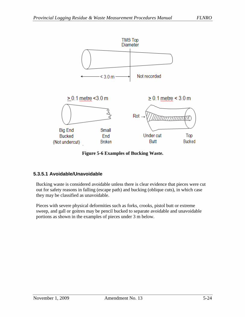
5.3.5.1 Avoidable/Unavoidable
Bucking waste is considered avoidable unless there is clear evidence that pieces were cut
out for safety reasons in falling (escape path) and bucking (oblique cuts), in which case
they may be classified as unavoidable.
Pieces with severe physical deformities such as forks, crooks, pistol butt or extreme
sweep, and gall or goitres may be pencil bucked to separate avoidable and unavoidable
portions as shown in the examples of pieces under 3 m below.
Timber Pricing Branch Reporting
5-25 Amendment No. 13 November 1, 2009
Figure 5-7 Avoidable/unavoidable Bucking Waste.
5.3.6 Breakage
Breakage is defined as any piece, meeting the minimum diameter of the TMS, which is
shorter than 3 m in length and broken at the large end or broken at both ends.
If it resulted from "normal" falling or yarding, it is unavoidable and not tallied.
If it is excessive (or careless) it is considered avoidable and is tallied as such. In this
case, it will be included in the cut-control volume.
This definition is not consistent with the inventory definition of breakage nor is it
intended to be.
Undercut butts less than 3 m in length with a broken top are classified as breakage and
should not be tallied.

Provincial Logging Residue & Waste Measurement Procedures Manual FLNRO
November 1, 2009 Amendment No. 13 5-26
Figure 5-8 Examples of Breakage.
5.3.6.1 Recording Breakage
Normal breakage is not usually recorded.
If a licensee wishes to measure breakage for its own purposes, it should all be tallied as
unavoidable breakage which is not included in the cut-control volumes.
However, where breakage is considered excessive because of an inadequate harvesting
method or was intentionally caused by the logging crew, it should all be recorded as
avoidable waste. These volumes will be included in the cut-control volume.
In addition, breakage must be measured and charged to cut control where the inventory
for the TSA or TFL has not been netted down for breakage. Breakage is recorded as "B"
under "Kind of Material" on the FS 161 (Plot Survey Card).
A log lying in a dispersed area that is heavily fractured and common sense indicates that
it would likely break into chunks below the TMS specifications in handling between
"stump to dump", should be classified as breakage and not recorded.
5.3.7 Forks
A fork is defined to be a division of a log into two or more stems. Forks which measure
greater than 3 m are measured as logs. If the diameters of forks are greater than or equal
to the minimum diameter of the timber merchantability specifications, the portion(s) of
the tree, above the fork or crook must meet the criteria for minimum log length to be
considered avoidable waste.
If the portion(s) of the tree, above the fork or crook, doesn't meet the minimum log length
criteria (3 m), it is considered unavoidable waste and must be recorded for cut control
purposes.
In Figure 5.9, segment A, if visually extended to the minimum top diameter (5R), would
meet the minimum log length (3 m); therefore, is classified as avoidable waste.
Timber Pricing Branch Reporting
5-27 Amendment No. 13 November 1, 2009
However, segment B, if visually extended to the minimum top diameter (5R), would not
meet the minimum log length (3 m) and therefore is classified as unavoidable waste.
Segment C is recorded as unavoidable waste for safety reasons because lumber cannot be
cut from it. The maximum length of segment C is 0.3 m unless the butt end of segment D
shows two separate piths and then segments C and D are recorded as one unavoidable
segment.
Segment D (with one pith showing) is recorded as avoidable waste.
Figure 5-9 Forked Log.
Segments A, B, C and D are recorded as separate pieces on the FS 161, each with its own
piece number. Use FK as comment code to indicate the pieces belong to a fork.
5.3.8 Long Butts
For long butts under 3 m in length, pieces that are less than 50 percent sound are not
required to be recorded; pieces that are more than 50 percent sound, the entire piece (net
volume) is classified and graded as avoidable sawlog waste. In the Interior, if the long
butt originated from a dead tree, it may be classified as avoidable grade 3 waste.
If there is clear evidence that bucking was done to raise the grade of the parent log from
lumber reject to sawlog, then the long butt may be graded lumber reject. Log butts may
be downgraded for forks, crooks, excessive twist, or oversized knots.
For long butts over 3 m in length, the piece is measured and graded as a log.
5.3.9 Coarse Woody Debris
Log pieces that may be required to meet coarse woody debris requirements are included
in the waste benchmarks. No special provisions are made for coarse woody debris in
waste assessments.
Provincial Logging Residue & Waste Measurement Procedures Manual FLNRO
November 1, 2009 Amendment No. 13 5-28
5.3.10 Special Cases
Waste surveyors often encounter pieces, usually less than the minimum log length, that
are hard to classify as waste or breakage, or as avoidable or unavoidable. A few of these
circumstances are listed here:
a. embedded rock, usually resulting from blasting. If the pieces are trimmed within
20 cm of the rock, such pieces may be classified as unavoidable. If the pieces
have been trimmed longer, the segment beyond the rock should be classified as
avoidable, without making any trim allowance,
b. chunks on the tail-spar or skidding trails used to support the roadbeds, that
resulted in the breakage of pieces greater than the minimum log length. Such
pieces are classified as avoidable, and may be graded according to the
characteristics of the whole piece,
c. windfalls will be tallied in the usual manner for in-plot portions. The exceptions
are windfalls that are blown down after harvesting with their roots sitting outside
the block. These pieces will not be tallied,
d. helicopter bucking waste. Incorrect estimation of log weights may result in having
to buck the logs shorter after attempting to lift them. Such waste is always
regarded as avoidable,
e. chunks in the landing, bucked at both ends and used to support a steel tower.
Classify as avoidable waste and grade as per the parent log,
f. avoidable breakage is recorded,
g. unavoidable breakage is not recorded, or
h. unavoidable bucking waste is recorded.
Timber Pricing Branch Reporting
5-29 Amendment No. 25 August 1, 2016
5.4 Field Standards
Those responsible for waste assessments must ensure that proper field procedures are
followed, including the use of industry standard equipment, materials and conventions.
Assessments which are not carried out properly will be rejected by the District Manager.
5.4.1 Maps
The block survey map should be at a scale of 1:5000 showing the cut-block boundaries,
roads, landings, strata and other features required to correctly determine the area logged.
If acceptable to the District Manager, another large scale may be used. In addition, the
plot locations, base lines and points of commencement must be marked.
The style and map notation must be consistent with good forestry practice. Map symbols
should be explained if they are not obvious. The cartographic standards used by the
Ministry of Forests, Lands and Natural Resource Operations are mandatory.
5.4.2 Field Equipment and Supplies
The waste survey crew should use equipment that can perform the work within the
allowable error limits. The minimum recommended equipment is:
a. hand compass, with declination adjustment,
b. clinometer with percent scale,
c. topofil strings, 50 m metal or braided nylon chain, graduated in metres,
d. logger's tape,
e. BC metric scale stick,
f. axe; tree marking paint, and
g. tally book with waterproof tally cards, flagging ribbons, aluminum tags and felt
markers.
The tie-points, plot centres, plot boundaries, and measured pieces must be clearly marked
in the field. Tie points and plot centres must be marked with a solid stake well-driven
into the ground, taped or painted, and numbered on aluminum tags, or with permanent felt
marker. Orange paint is recommended for stakes. Plot boundaries and pieces must be
clearly marked. The accuracy of boundary marking is only critical when measured pieces
cross the boundary. Blue paint is recommended for boundaries and pieces. Paint must
be log or tree-marking grade.
Provincial Logging Residue & Waste Measurement Procedures Manual FLNRO
November 1, 2009 Amendment No. 13 5-30
5.4.3 Traverse Notes
When a field assessment involves traversing areas, proper notes must be kept to support
the area compilations. These notes will show:
a. the forward sighting of the bearings,
b. the slope in degrees or percent,
c. slope distances in metres,
d. horizontal distances in metres, and
e. retain traverse notes with all other working papers for inspection by Forest
Service check-survey or audit staff.
Any typing within subpopulations must be supported by field notes and may not be done
on a plot-by-plot basis.
Plot Tallies
Plot tally cards must contain at least the information prescribed in this manual, and be in
the prescribed format. They must be printed on moisture-resistant and durable field
material.
Timber Pricing Branch Reporting
5-31 Amendment No. 13 November 1, 2009
5.5 Measurement Protocol and Standards
5.5.1 Lengths
Lengths will be recorded to the nearest tenth (0.1) of a metre:
for exact 0.05 m lengths round to the lower tenth (0.1) of a metre.
Example:
A log 4.25 m in length - record as 4.2 m
A log 4.26 m in length - record as 4.3 m
The determination of KIND (logs, bucking waste, breakage) is made on the basis of gross
length.
5.5.1.1 Broken Tops
The length measurement procedures for broken tops are (refer to Figure 5.10):
Step 1 Locate the TMS top diameter (must have minimum slab thickness of 5R)
measured from the small end.
Step 2 Measure gross length which commences from the top diameter.
Step 3 Locate the X Y line upon which the volume above the top diameter to the
X Y line (Section B) equals to the void of the missing wood (Section A).
Step 4 Record a length deduction which is measured from the top diameter to
the X Y line.
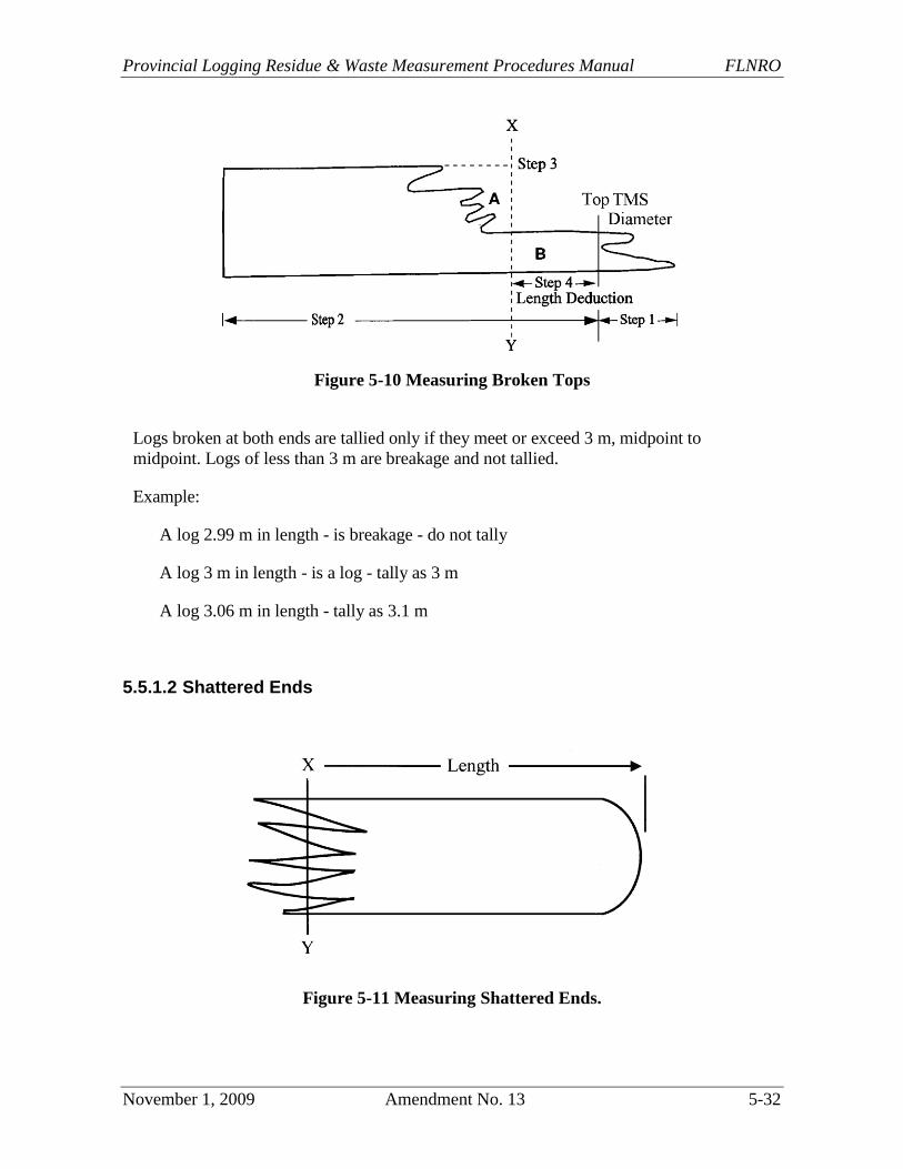
Provincial Logging Residue & Waste Measurement Procedures Manual FLNRO
November 1, 2009 Amendment No. 13 5-32
Figure 5-10 Measuring Broken Tops
Logs broken at both ends are tallied only if they meet or exceed 3 m, midpoint to
midpoint. Logs of less than 3 m are breakage and not tallied.
Example:
A log 2.99 m in length - is breakage - do not tally
A log 3 m in length - is a log - tally as 3 m
A log 3.06 m in length - tally as 3.1 m
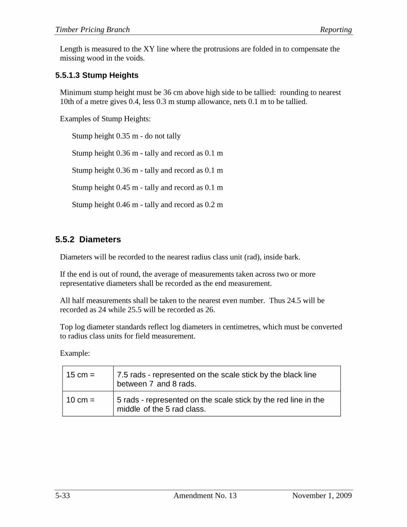
5.5.1.2 Shattered Ends
Figure 5-11 Measuring Shattered Ends.
Timber Pricing Branch Reporting
5-33 Amendment No. 13 November 1, 2009
Length is measured to the XY line where the protrusions are folded in to compensate the
missing wood in the voids.
5.5.1.3 Stump Heights
Minimum stump height must be 36 cm above high side to be tallied: rounding to nearest
10th of a metre gives 0.4, less 0.3 m stump allowance, nets 0.1 m to be tallied.
Examples of Stump Heights:
Stump height 0.35 m - do not tally
Stump height 0.36 m - tally and record as 0.1 m
Stump height 0.36 m - tally and record as 0.1 m
Stump height 0.45 m - tally and record as 0.1 m
Stump height 0.46 m - tally and record as 0.2 m
5.5.2 Diameters
Diameters will be recorded to the nearest radius class unit (rad), inside bark.
If the end is out of round, the average of measurements taken across two or more
representative diameters shall be recorded as the end measurement.
All half measurements shall be taken to the nearest even number. Thus 24.5 will be
recorded as 24 while 25.5 will be recorded as 26.
Top log diameter standards reflect log diameters in centimetres, which must be converted
to radius class units for field measurement.
Example:
15 cm = 7.5 rads - represented on the scale stick by the black line between 7 and 8 rads.
10 cm = 5 rads - represented on the scale stick by the red line in the middle of the 5 rad class.
Provincial Logging Residue & Waste Measurement Procedures Manual FLNRO
November 1, 2009 Amendment No. 13 5-34
5.5.2.1 Stump Diameters
In the Interior, a minimum diameter at stump height (outside bark) is specified in the
timber merchantability specification and this dsh is measured at a point 0.3 m above the
high side of the stump. The minimum dsh must be obtained without rounding up or the
stump is grade 6 and doesn't have to be tallied.
All tallied stumps have their top diameters measured and recorded inside bark so it is
possible to have a stump diameter which is less than the minimum dsh.
If the stump total height, which includes the TMS of 30 cm, is less than 1.3 m, measure
the top diameter on the top of the stump. If the stump total height exceeds 1.3 m,
measure the top diameter at 1.3 m above the ground on the high side.
On the Coast, where no minimum dsh is specified, a stump will only be considered if a
log equal to or exceeding the timber merchantability specifications was deemed to have
been cut from it.
Where no minimum dsh is specified, the minimum dbh above high-side in the cruise will
apply as the minimum dsh (inside bark). That is, 12.0 cm dbh (outside bark, immature on
the Coast) will be a 6.0 rad dsh; a 17.5 cm dbh (mature on the Coast) will be rounded up
to 9.0 rads dsh.
5.5.3 Bucking Waste
Cut at both ends - tally to the nearest tenth (0.1) of a metre regardless of length.
Cut at large end - tally as waste if length meets or exceeds a tenth (0.1) of a metre.
Example:
0.09 m in length - do not tally,
0.10 m in length - tally as a tenth (0.1) of a metre.
Timber Pricing Branch Reporting
5-35 Amendment No. 13 November 1, 2009
5.5.4 Deductions
Deductions for defect should be calculated in the field using the British Columbia metric
scale stick.
The compilation program will subtract numbers (if any) in the deduction columns for
length, top and/or butt from gross length, top and/or butt dimensions respectively. The
resulting dimensions will then be used to calculate volume.
The numbers that are tallied in the deduction columns are not actual dimensions but
length or radius deductions, i.e., a log with gross dimensions of 4.2 m and 18 rad top / 20
rad butt with 0.6 m, 2 rad top and 5 rad butt deductions would be calculated as a 3.6 m,
16 rad top / 15 rad butt log.
Provincial Logging Residue & Waste Measurement Procedures Manual FLNRO
November 1, 2009 Amendment No. 13 5-36
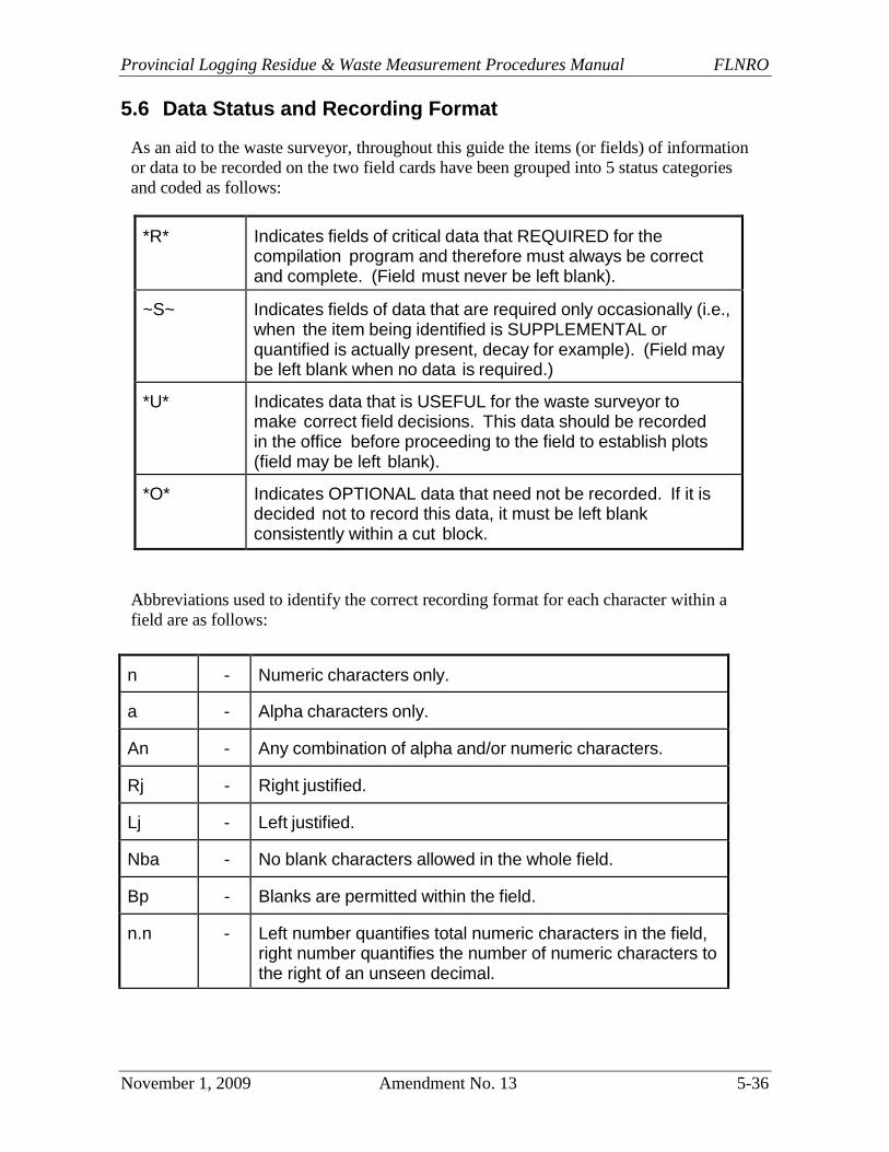
5.6 Data Status and Recording Format
As an aid to the waste surveyor, throughout this guide the items (or fields) of information
or data to be recorded on the two field cards have been grouped into 5 status categories
and coded as follows:
*R* Indicates fields of critical data that REQUIRED for the compilation program and therefore must always be correct and complete. (Field must never be left blank).
~S~ Indicates fields of data that are required only occasionally (i.e., when the item being identified is SUPPLEMENTAL or quantified is actually present, decay for example). (Field may be left blank when no data is required.)
*U* Indicates data that is USEFUL for the waste surveyor to make correct field decisions. This data should be recorded in the office before proceeding to the field to establish plots (field may be left blank).
*O* Indicates OPTIONAL data that need not be recorded. If it is decided not to record this data, it must be left blank consistently within a cut block.
Abbreviations used to identify the correct recording format for each character within a
field are as follows:
n - Numeric characters only.
a - Alpha characters only.
An - Any combination of alpha and/or numeric characters.
Rj - Right justified.
Lj - Left justified.
Nba - No blank characters allowed in the whole field.
Bp - Blanks are permitted within the field.
n.n - Left number quantifies total numeric characters in the field, right number quantifies the number of numeric characters to the right of an unseen decimal.
Timber Pricing Branch Reporting
5-37 Amendment No. 25 August 1, 2015
5.7 Completing the FS 444 (Block Summary Card)
One FS 444 must be completed for each block sampled regardless of which sampling
option has been chosen and the number of plots to be established in it.
This section may be further revised when the new Waste System is in full
implementation.
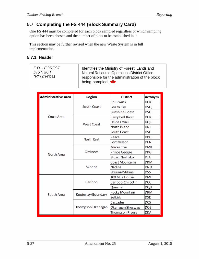
5.7.1 Header
F.D. - FOREST DISTRICT *R* (2n-nba)
Identifies the Ministry of Forest, Lands and Natural Resource Operations District Office responsible for the administration of the block being sampled.
Provincial Logging Residue & Waste Measurement Procedures Manual FLNRO
August 1, 2015 Amendment No. 25 5-38
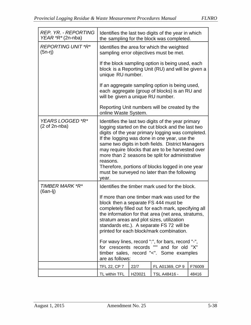
REP. YR. - REPORTING YEAR *R* (2n-nba)
Identifies the last two digits of the year in which the sampling for the block was completed.
REPORTING UNIT *R* (5n-rj)
Identifies the area for which the weighted sampling error objectives must be met.
If the block sampling option is being used, each block is a Reporting Unit (RU) and will be given a unique RU number.
If an aggregate sampling option is being used, each aggregate (group of blocks) is an RU and will be given a unique RU number.
Reporting Unit numbers will be created by the online Waste System.
YEARS LOGGED *R* (2 of 2n-nba)
Identifies the last two digits of the year primary logging started on the cut block and the last two digits of the year primary logging was completed. If the logging was done in one year, use the same two digits in both fields. District Managers may require blocks that are to be harvested over more than 2 seasons be split for administrative reasons. Therefore, portions of blocks logged in one year must be surveyed no later than the following year.
TIMBER MARK *R* (6an-lj)
Identifies the timber mark used for the block.
If more than one timber mark was used for the block then a separate FS 444 must be completely filled out for each mark, specifying all the information for that area (net area, stratums, stratum areas and plot sizes, utilization standards etc.). A separate FS 72 will be printed for each block/mark combination.
For wavy lines, record ":", for bars, record "-", for crescents records ""' and for old "X" timber sales, record "<". Some examples are as follows:
TFL 22, CP 7 22/7 FL A01369, CP 9 F76009
TL within TFL HZ0021 TSL A48416 - 48416
Timber Pricing Branch Reporting
5-39 Amendment No. 25 August 1, 2015
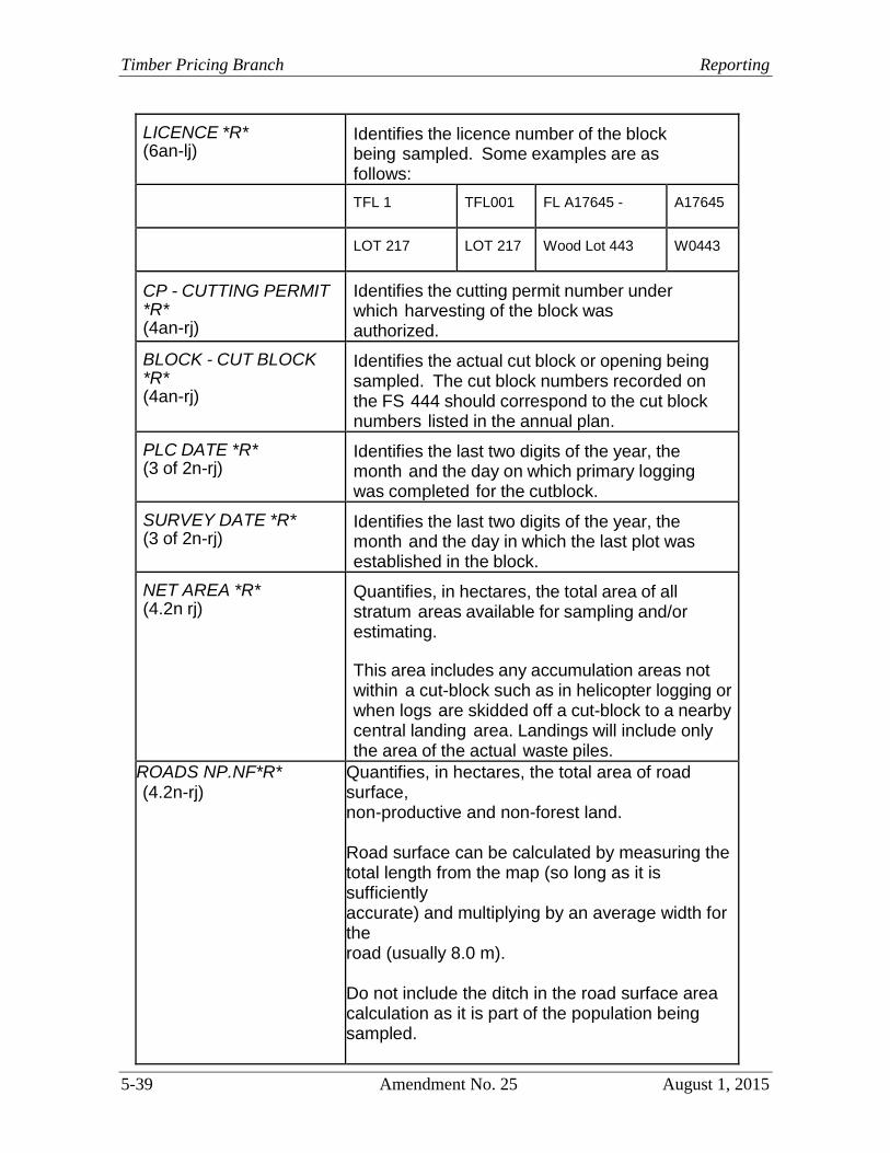
LICENCE *R* (6an-lj)
Identifies the licence number of the block being sampled. Some examples are as follows:
TFL 1 TFL001 FL A17645 - A17645
LOT 217 LOT 217 Wood Lot 443 W0443
CP - CUTTING PERMIT *R* (4an-rj)
Identifies the cutting permit number under which harvesting of the block was authorized.
BLOCK - CUT BLOCK *R* (4an-rj)
Identifies the actual cut block or opening being sampled. The cut block numbers recorded on the FS 444 should correspond to the cut block numbers listed in the annual plan.
PLC DATE *R* (3 of 2n-rj)
Identifies the last two digits of the year, the month and the day on which primary logging was completed for the cutblock.
SURVEY DATE *R* (3 of 2n-rj)
Identifies the last two digits of the year, the month and the day in which the last plot was established in the block.
NET AREA *R* (4.2n rj)
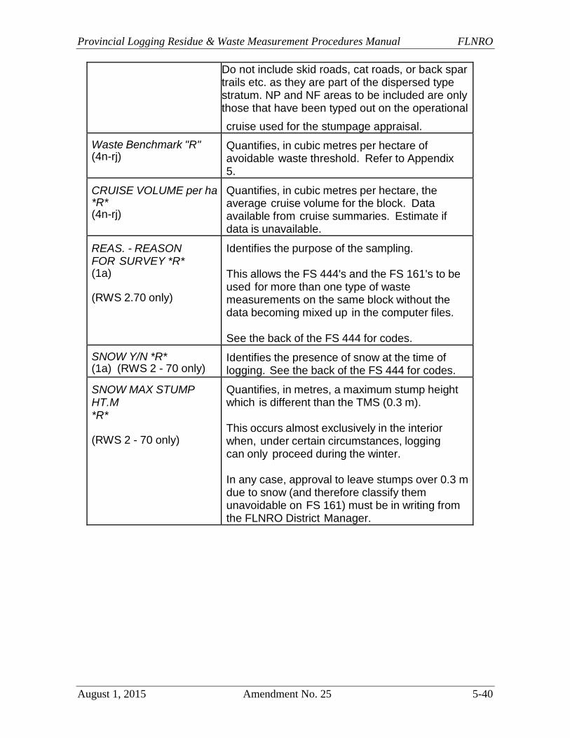
Quantifies, in hectares, the total area of all stratum areas available for sampling and/or estimating.
This area includes any accumulation areas not within a cut-block such as in helicopter logging or when logs are skidded off a cut-block to a nearby central landing area. Landings will include only the area of the actual waste piles.
ROADS NP.NF*R* (4.2n-rj)
Quantifies, in hectares, the total area of road surface, non-productive and non-forest land. Road surface can be calculated by measuring the total length from the map (so long as it is sufficiently accurate) and multiplying by an average width for the road (usually 8.0 m). Do not include the ditch in the road surface area calculation as it is part of the population being sampled.
Provincial Logging Residue & Waste Measurement Procedures Manual FLNRO
August 1, 2015 Amendment No. 25 5-40
Do not include skid roads, cat roads, or back spar trails etc. as they are part of the dispersed type stratum. NP and NF areas to be included are only those that have been typed out on the operational
cruise used for the stumpage appraisal.
Waste Benchmark "R" (4n-rj)
Quantifies, in cubic metres per hectare of avoidable waste threshold. Refer to Appendix 5.
CRUISE VOLUME per ha *R* (4n-rj)
Quantifies, in cubic metres per hectare, the average cruise volume for the block. Data available from cruise summaries. Estimate if data is unavailable.
REAS. - REASON FOR SURVEY *R* (1a)
(RWS 2.70 only)
Identifies the purpose of the sampling.
This allows the FS 444's and the FS 161's to be used for more than one type of waste measurements on the same block without the data becoming mixed up in the computer files.
See the back of the FS 444 for codes.
SNOW Y/N *R* (1a) (RWS 2 - 70 only)
Identifies the presence of snow at the time of logging. See the back of the FS 444 for codes.
SNOW MAX STUMP HT.M *R*
(RWS 2 - 70 only)
Quantifies, in metres, a maximum stump height which is different than the TMS (0.3 m).
This occurs almost exclusively in the interior when, under certain circumstances, logging can only proceed during the winter.
In any case, approval to leave stumps over 0.3 m due to snow (and therefore classify them unavoidable on FS 161) must be in writing from the FLNRO District Manager.
Timber Pricing Branch Reporting
5-41 Amendment No. 25 August 1, 2015
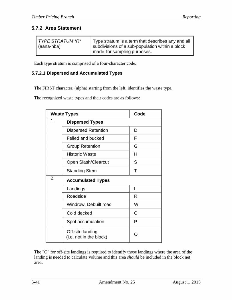
5.7.2 Area Statement
Each type stratum is comprised of a four-character code.
5.7.2.1 Dispersed and Accumulated Types
The FIRST character, (alpha) starting from the left, identifies the waste type.
The recognized waste types and their codes are as follows:
Waste Types Code
1. Dispersed Types
Dispersed Retention D
Felled and bucked F
Group Retention G
Historic Waste H
Open Slash/Clearcut S
Standing Stem T
2. Accumulated Types
Landings L
Roadside R
Windrow, Debuilt road W
Cold decked C
Spot accumulation P
Off-site landing (i.e. not in the block)
O
The "O" for off-site landings is required to identify those landings where the area of the
landing is needed to calculate volume and this area should be included in the block net
area.
TYPE STRATUM *R* (aana-nba)
Type stratum is a term that describes any and allsubdivisions of a sub-population within a block made for sampling purposes.
Provincial Logging Residue & Waste Measurement Procedures Manual FLNRO
August 1, 2015 Amendment No. 25 5-42
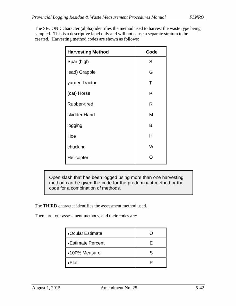
The SECOND character (alpha) identifies the method used to harvest the waste type being
sampled. This is a descriptive label only and will not cause a separate stratum to be
created. Harvesting method codes are shown as follows:
Harvesting Method Code
Spar (high
lead) Grapple
yarder Tractor
(cat) Horse
Rubber-tired
skidder Hand
logging
Hoe
chucking
Helicopter
Wyssen
Other
Any combination
S
G
T
P
R
M
B
H
W
O
C
The THIRD character identifies the assessment method used.
There are four assessment methods, and their codes are:
●Ocular Estimate O
●Estimate Percent E
●100% Measure S
●Plot P
Open slash that has been logged using more than one harvesting method can be given the code for the predominant method or the code for a combination of methods.

Timber Pricing Branch Reporting
5-43 Amendment No. 25 August 1, 2015
When a method other than plot is used, use the "alpha" method code.
When the plot method is used, select the "Numeric" code that corresponds with the plot
size in the table below. There must be at least two plots in each stratum.
0 - 50 m2 5 - 500 m2
1 -100 m2 6 - 600 m2
2- 200 m2 7 - 1 000 m2
3 - 300 m2 8 - 5 000 m2
4 - 400 m2 9 - 10 000 m2
The FOURTH character (alphanumeric) identifies any substratification of waste types
into waste levels.
When significantly different levels of waste occur within a waste type and they can be
easily identified and mapped, the waste surveyor must substratify them into waste levels.
The codes: "L", "M" and "H" for "light, medium and heavy" respectively or one to nine
(1 to 9) may be used.
If no substratification is done, or for 100 percent piece scales, record "X".
Stratification of accumulation waste types, when significantly different waste levels exist,
can help accomplish this in either sampling option.
Stratification of dispersed waste types could also be beneficial in the cut block sampling
option. It will, however, be of limited use in the aggregate sampling option due to the
generally small number of plots involved.
Where the plot method is used, each stratum created in either the accumulation or
dispersed sub-population requires a minimum of two plots.
Stratification, if done carefully, can reduce the coefficient of variation and therefore also reduce the sampling error.
If sampling error is reduced with good stratification in the field, it is possible to reduce the number of plots required for the next sampling year.
Provincial Logging Residue & Waste Measurement Procedures Manual FLNRO
August 1, 2015 Amendment No. 25 5-44
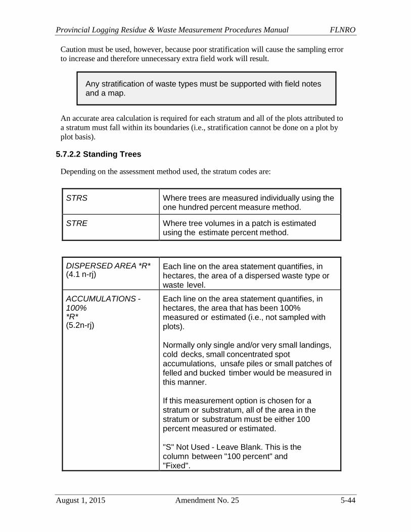
Caution must be used, however, because poor stratification will cause the sampling error
to increase and therefore unnecessary extra field work will result.
An accurate area calculation is required for each stratum and all of the plots attributed to
a stratum must fall within its boundaries (i.e., stratification cannot be done on a plot by
plot basis).
5.7.2.2 Standing Trees
Depending on the assessment method used, the stratum codes are:
STRS Where trees are measured individually using the one hundred percent measure method.
STRE Where tree volumes in a patch is estimated using the estimate percent method.
DISPERSED AREA *R* (4.1 n-rj)
Each line on the area statement quantifies, in hectares, the area of a dispersed waste type or waste level.
ACCUMULATIONS - 100% *R* (5.2n-rj)
Each line on the area statement quantifies, in hectares, the area that has been 100% measured or estimated (i.e., not sampled with plots).
Normally only single and/or very small landings, cold decks, small concentrated spot accumulations, unsafe piles or small patches of felled and bucked timber would be measured in this manner.
If this measurement option is chosen for a stratum or substratum, all of the area in the stratum or substratum must be either 100 percent measured or estimated.
"S" Not Used - Leave Blank. This is the column between "100 percent" and "Fixed".
Any stratification of waste types must be supported with field notes and a map.
Timber Pricing Branch Reporting
5-45 Amendment No. 25 August 1, 2015
FIXED *R* (5.2n-rj)
Each line on the area statement quantifies, in hectares, the area of any accumulated types or waste levels (i.e. type stratum) that have been sampled with plots of a fixed radius (a 400 m2
plot = 11.28 m radius).
3P Not used - leave blank.
PLOT SZ m2 - PLOT SIZE *R* (3n-rj)
Each line quantifies, in square metres, the plot size used for the various type stratum.
The normal plot size for dispersed types is 400
m2 (circular with radius of 11.28 m). Smaller plot sizes are allowed for partial cutting.
Accumulated types can be sampled with a 50 m2 plot (circular with radius of 3.99 m), or rectangular or square plots of 100, 200, or 400 m2.
The plot radius formula is ( plot size (m2 ) / ) .
GRID DlST.m - GRID DISTANCE *R* (3n-rj)
Quantifies, in metres, the horizontal distance between plots on a strip and between strips on a baseline for dispersed types.
It can also be used to quantify the horizontal distance between plots along the roadside accumulations.
SECOND OLD GR - SECOND or OLD GROWTH *U* (1a)
Identifies the predominant age class of the timber that was in the cut block.
Codes are "O" for old growth (121 years and older) and "S" for second growth (under 121 years).
GRADES *U* (1a)
Identifies whether Coast or Interior grades are applicable for the block. I = Interior and C = Coast.
All plots within a type stratum must be the same size.
Provincial Logging Residue & Waste Measurement Procedures Manual FLNRO
August 1, 2015 Amendment No. 25 5-46
5.7.3 Timber Merchantability Specifications
These specifications are described in this manual.
SPECIES *R* (2a-bp)
Identifies the species.
Where the species is blanked out on the first line, the blank refers to all species).
MSH cm - MAXIMUM STUMP HEIGHT *R* (2n-rj)
Quantifies, in centimetres, the TMS stump height allowed of 30 cm.
TOP cm *R* (2n-rj)
Quantifies, in centimetres, the minimum top diameter, inside bark.
On the coast it is always 15 cm for old growth timber and 10 cm for second growth.
In the Interior, for red cedar 140 years or older, the top diameter is 15 cm; for younger red cedar and all other coniferous species it is 10 cm.
MLL m - MINIMUM LOG LENGTH *R* (2.1n-rj)
Quantifies, in metres, the minimum log length that must be recovered.
Currently it is 3 m for both the Coast and the Interior.
AGE *R* (3n-rj)
Identifies the age of any species. Applies to the Interior only, leave blank on the Coast.
Timber Pricing Branch Reporting
5-47 Amendment No. 25 August 1, 2015
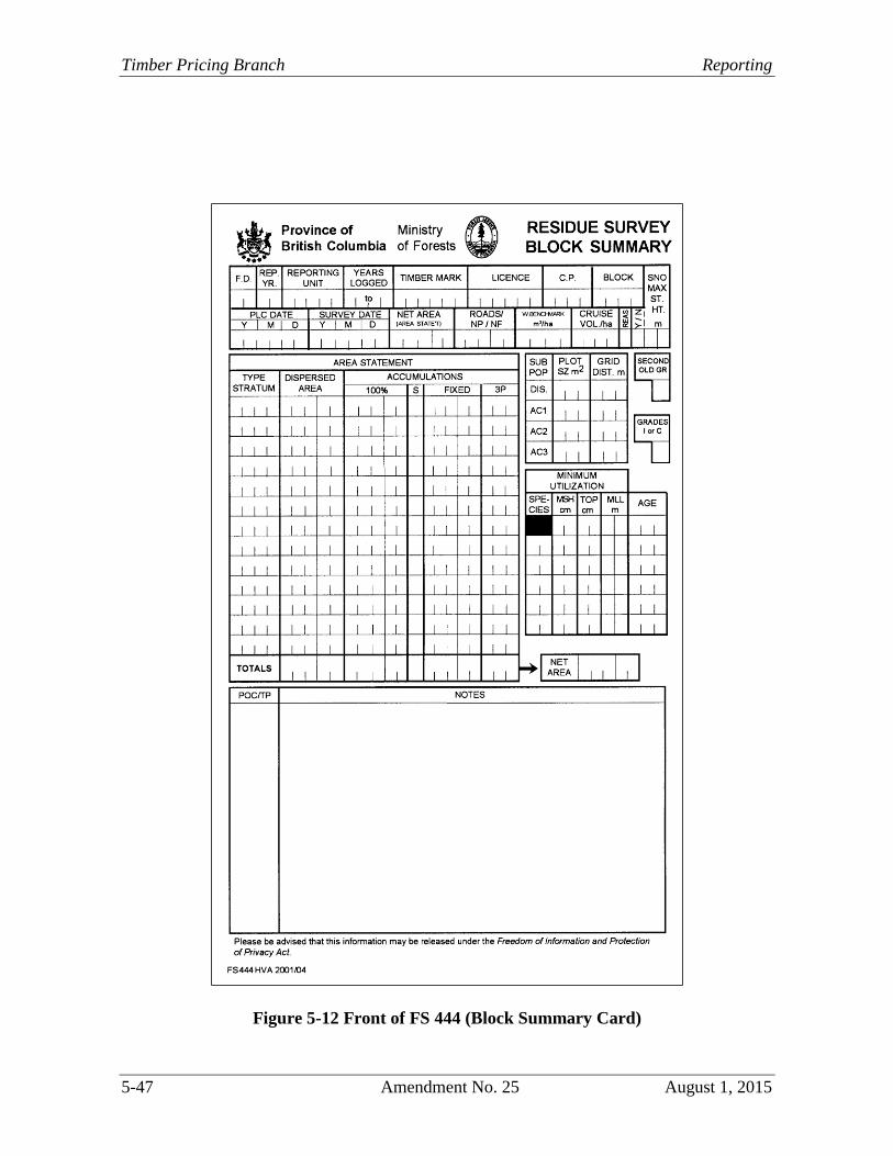
Figure 5-12 Front of FS 444 (Block Summary Card)
Provincial Logging Residue & Waste Measurement Procedures Manual FLNRO
August 1, 2015 Amendment No. 25 5-48
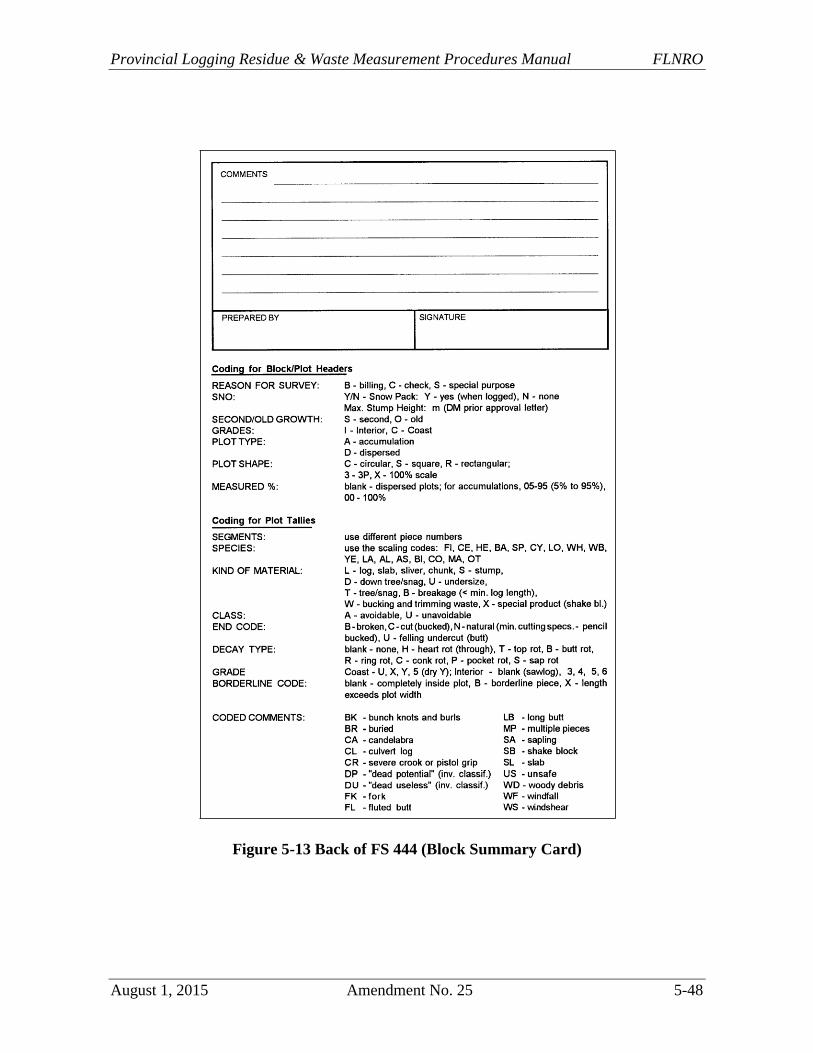
Figure 5-13 Back of FS 444 (Block Summary Card)
Timber Pricing Branch Reporting
5-49 Amendment No. 25 August 1, 2015
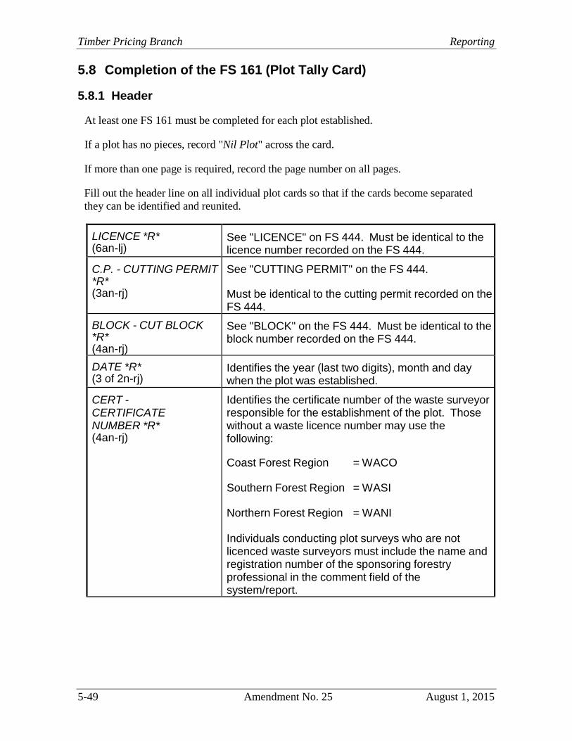
5.8 Completion of the FS 161 (Plot Tally Card)
5.8.1 Header
At least one FS 161 must be completed for each plot established.
If a plot has no pieces, record "Nil Plot" across the card.
If more than one page is required, record the page number on all pages.
Fill out the header line on all individual plot cards so that if the cards become separated
they can be identified and reunited.
LICENCE *R* (6an-lj)
See "LICENCE" on FS 444. Must be identical to the licence number recorded on the FS 444.
C.P. - CUTTING PERMIT *R* (3an-rj)
See "CUTTING PERMIT" on the FS 444.
Must be identical to the cutting permit recorded on the FS 444.
BLOCK - CUT BLOCK *R* (4an-rj)
See "BLOCK" on the FS 444. Must be identical to the block number recorded on the FS 444.
DATE *R* (3 of 2n-rj)
Identifies the year (last two digits), month and day when the plot was established.
CERT - CERTIFICATE NUMBER *R* (4an-rj)
Identifies the certificate number of the waste surveyor responsible for the establishment of the plot. Those without a waste licence number may use the following:
Coast Forest Region = WACO
Southern Forest Region = WASI
Northern Forest Region = WANI
Individuals conducting plot surveys who are not licenced waste surveyors must include the name and registration number of the sponsoring forestry professional in the comment field of the system/report.

Provincial Logging Residue & Waste Measurement Procedures Manual FLNRO
August 1, 2015 Amendment No. 25 5-50
RET # - RETURN NUMBER *R* (3n-rj)
Identifies the return number of the waste surveyor responsible for the establishment of the plot.
Return numbers will increment by one for each new block sampled in a given year.
B.LINE - BASELINE *R* (1a)
Identifies the baseline the plot is tied to.
Use codes "A" "B" "C" etc.
STRIP *R* (2n-rj)
Identifies the strip number that plots are located on.
PLOT NO. *R* (2nrj)
Identifies the plot number. The strip/plot number combination must be unique within a type stratum.
TY. - PLOT TYPE *R* (1a) (used only in RWS 2.70 program only)
Use this field to identify the subpopulation type for the plot as recorded on the FS 444. Use codes, "D" for dispersed, "A" for accumulation, "E" for estimate or "M" for 100 percent scale.
PLOT SH – PLOT SHAPE *R* (1a-bp) (RWS 2.70 only)
Identifies the plot shape. Use codes “C” = Circular, “R” = Rectangular, “S” = Square. Must be blank for estimated plots and 100 percent measure plots.
MEAS.% - MEASURE % *R* (2n-rj)
Quantifies the percentage of the volume, within the plot boundaries that has been measured and recorded.
A reasonable effort must be made to measure as much as possible even if one end of the piece cannot be seen and must be estimated.
See the codes on the back of the FS 444.
For RWS 2.70, use code 00 for 100 percent. For the new waste system, measure percent is always defaulted to 100.
It is the responsibility of each certified waste surveyor to keep track of his/her own return number. These numbers automatically revert to "001" on January 1st of each year.
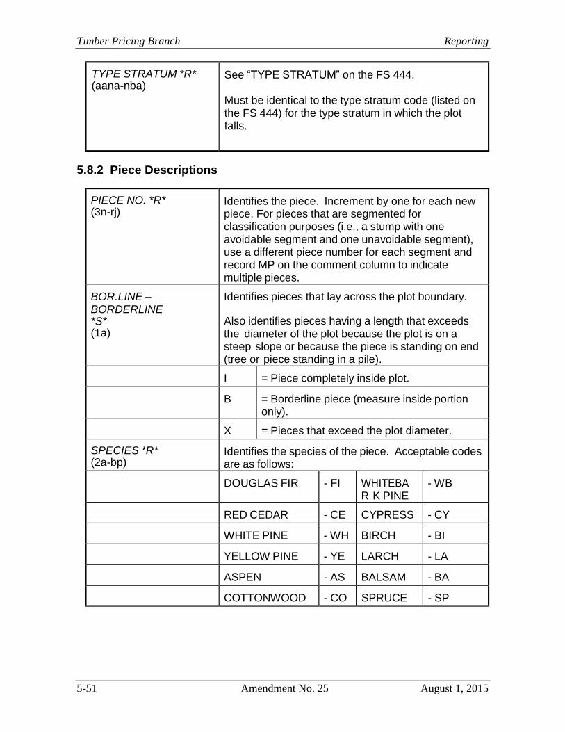
Timber Pricing Branch Reporting
5-51 Amendment No. 25 August 1, 2015
TYPE STRATUM *R* (aana-nba)
See “TYPE STRATUM” on the FS 444.
Must be identical to the type stratum code (listed on the FS 444) for the type stratum in which the plot falls.
5.8.2 Piece Descriptions
PIECE NO. *R* (3n-rj)
Identifies the piece. Increment by one for each new piece. For pieces that are segmented for classification purposes (i.e., a stump with one avoidable segment and one unavoidable segment), use a different piece number for each segment and record MP on the comment column to indicate multiple pieces.
BOR.LINE – BORDERLINE *S* (1a)
Identifies pieces that lay across the plot boundary.
Also identifies pieces having a length that exceeds the diameter of the plot because the plot is on a steep slope or because the piece is standing on end (tree or piece standing in a pile).
I = Piece completely inside plot.
B = Borderline piece (measure inside portion
only).
X = Pieces that exceed the plot diameter.
SPECIES *R* (2a-bp)
Identifies the species of the piece. Acceptable codes are as follows:
DOUGLAS FIR - FI WHITEBA
R K PINE - WB
RED CEDAR - CE CYPRESS - CY
WHITE PINE - WH BIRCH - BI
YELLOW PINE - YE LARCH - LA
ASPEN - AS BALSAM - BA
COTTONWOOD - CO SPRUCE - SP
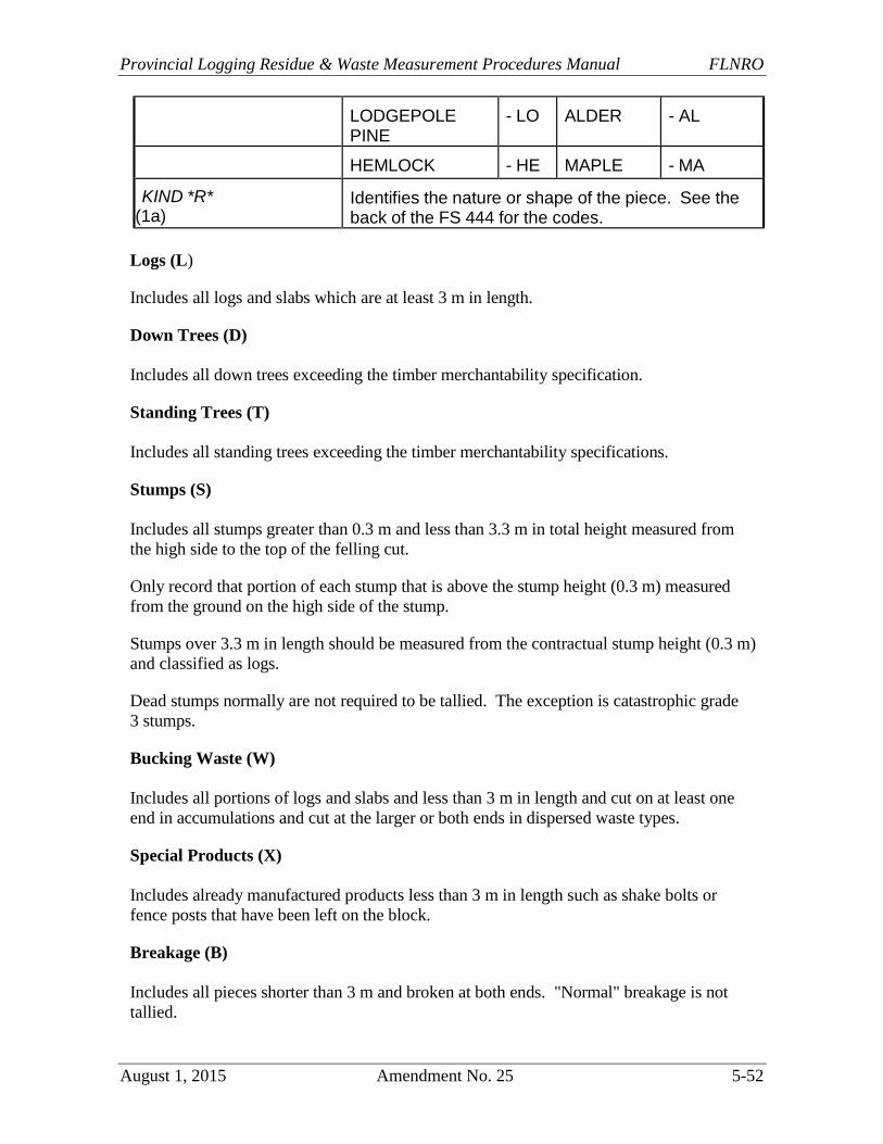
Provincial Logging Residue & Waste Measurement Procedures Manual FLNRO
August 1, 2015 Amendment No. 25 5-52
LODGEPOLE PINE
- LO ALDER - AL
HEMLOCK - HE MAPLE - MA
KIND *R* (1a)
Identifies the nature or shape of the piece. See the back of the FS 444 for the codes.
Logs (L)
Includes all logs and slabs which are at least 3 m in length.
Down Trees (D)
Includes all down trees exceeding the timber merchantability specification.
Standing Trees (T)
Includes all standing trees exceeding the timber merchantability specifications.
Stumps (S)
Includes all stumps greater than 0.3 m and less than 3.3 m in total height measured from
the high side to the top of the felling cut.
Only record that portion of each stump that is above the stump height (0.3 m) measured
from the ground on the high side of the stump.
Stumps over 3.3 m in length should be measured from the contractual stump height (0.3 m)
and classified as logs.
Dead stumps normally are not required to be tallied. The exception is catastrophic grade
3 stumps.
Bucking Waste (W)
Includes all portions of logs and slabs and less than 3 m in length and cut on at least one
end in accumulations and cut at the larger or both ends in dispersed waste types.
Special Products (X)
Includes already manufactured products less than 3 m in length such as shake bolts or
fence posts that have been left on the block.
Breakage (B)
Includes all pieces shorter than 3 m and broken at both ends. "Normal" breakage is not
tallied.
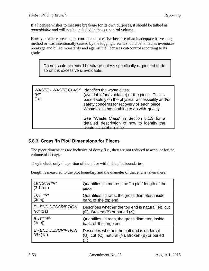
Timber Pricing Branch Reporting
5-53 Amendment No. 25 August 1, 2015
If a licensee wishes to measure breakage for its own purposes, it should be tallied as
unavoidable and will not be included in the cut-control volume.
However, where breakage is considered excessive because of an inadequate harvesting
method or was intentionally caused by the logging crew it should be tallied as avoidable
breakage and billed monetarily and against the licensees cut-control according to its
grade.
5.8.3 Gross ‘In Plot’ Dimensions for Pieces
The piece dimensions are inclusive of decay (i.e., they are not reduced to account for the
volume of decay).
They include only the portion of the piece within the plot boundaries.
Length is measured to the plot boundary and the diameter of that end is taken there.
LENGTH *R* (3.1 n-rj)
Quantifies, in metres, the "in plot" length of the piece.
TOP *R* (3n-rj)
Quantifies, in rads, the gross diameter, inside bark, of the top end.
E - END DESCRIPTION *R* (1a)
Describes whether the top end is natural (N), cut (C), Broken (B) or buried (X).
BUTT *R* (3n-rj)
Quantifies, in rads, the gross diameter, inside bark, of the large end.
E - END DESCRIPTION *R* (1a)
Describes whether the butt end is undercut (U), cut (C), natural (N), Broken (B) or buried (X).
Do not scale or record breakage unless specifically requested to do so or it is excessive & avoidable.
WASTE - WASTE CLASS *R* (1a)
Identifies the waste class (avoidable/unavoidable) of the piece. This is based solely on the physical accessibility and/or safety concerns for recovery of each piece. Waste class has nothing to do with quality.
See "Waste Class" in Section 5.1.3 for a detailed description of how to identify the waste class of a piece.
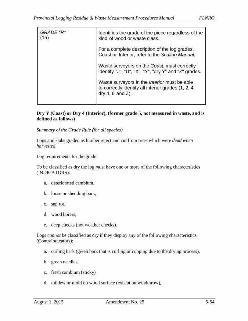
Provincial Logging Residue & Waste Measurement Procedures Manual FLNRO
August 1, 2015 Amendment No. 25 5-54
GRADE *R* (1a)
Identifies the grade of the piece regardless of the kind of wood or waste class.
For a complete description of the log grades, Coast or Interior, refer to the Scaling Manual.
Waste surveyors on the Coast, must correctly identify "J", "U", "X", "Y", “dry Y” and "Z" grades.
Waste surveyors in the Interior must be able to correctly identify all interior grades (1, 2, 4, dry 4, 6 and Z).
Dry Y (Coast) or Dry 4 (Interior), (former grade 5, not measured in waste, and is
defined as follows)
Summary of the Grade Rule (for all species)
Logs and slabs graded as lumber reject and cut from trees which were dead when
harvested.
Log requirements for the grade:
To be classified as dry the log must have one or more of the following characteristics
(INDICATORS):
a. deteriorated cambium,
b. loose or shedding bark,
c. sap rot,
d. wood borers,
e. deep checks (not weather checks).
Logs cannot be classified as dry if they display any of the following characteristics
(Contraindicators):
a. curling bark (green bark that is curling or cupping due to the drying process),
b. green needles,
c. fresh cambium (sticky)
d. mildew or mold on wood surface (except on windthrow),
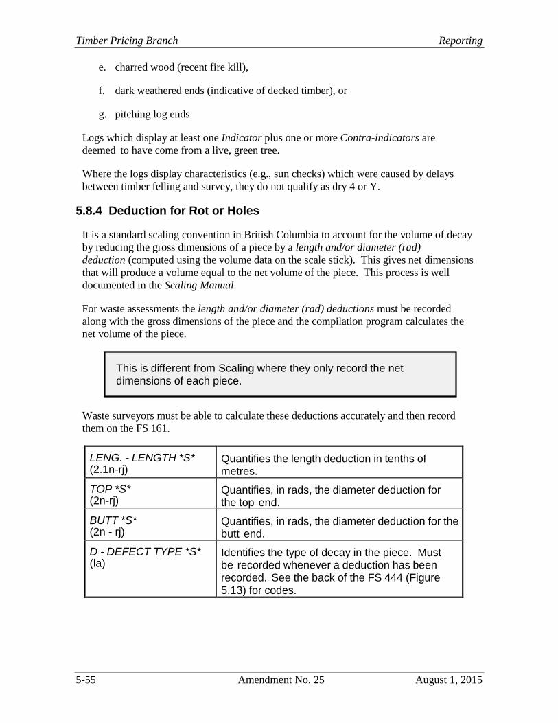
Timber Pricing Branch Reporting
5-55 Amendment No. 25 August 1, 2015
e. charred wood (recent fire kill),
f. dark weathered ends (indicative of decked timber), or
g. pitching log ends.
Logs which display at least one Indicator plus one or more Contra-indicators are
deemed to have come from a live, green tree.
Where the logs display characteristics (e.g., sun checks) which were caused by delays
between timber felling and survey, they do not qualify as dry 4 or Y.
5.8.4 Deduction for Rot or Holes
It is a standard scaling convention in British Columbia to account for the volume of decay
by reducing the gross dimensions of a piece by a length and/or diameter (rad)
deduction (computed using the volume data on the scale stick). This gives net dimensions
that will produce a volume equal to the net volume of the piece. This process is well
documented in the Scaling Manual.
For waste assessments the length and/or diameter (rad) deductions must be recorded
along with the gross dimensions of the piece and the compilation program calculates the
net volume of the piece.
Waste surveyors must be able to calculate these deductions accurately and then record
them on the FS 161.
LENG. - LENGTH *S* (2.1n-rj)
Quantifies the length deduction in tenths of metres.
TOP *S* (2n-rj)
Quantifies, in rads, the diameter deduction for the top end.
BUTT *S* (2n - rj)
Quantifies, in rads, the diameter deduction for the butt end.
D - DEFECT TYPE *S* (la)
Identifies the type of decay in the piece. Must be recorded whenever a deduction has been recorded. See the back of the FS 444 (Figure 5.13) for codes.
This is different from Scaling where they only record the net dimensions of each piece.
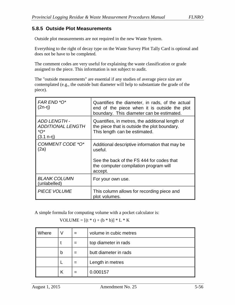
Provincial Logging Residue & Waste Measurement Procedures Manual FLNRO
August 1, 2015 Amendment No. 25 5-56
5.8.5 Outside Plot Measurements
Outside plot measurements are not required in the new Waste System.
Everything to the right of decay type on the Waste Survey Plot Tally Card is optional and
does not be have to be completed.
The comment codes are very useful for explaining the waste classification or grade
assigned to the piece. This information is not subject to audit.
The "outside measurements" are essential if any studies of average piece size are
contemplated (e.g., the outside butt diameter will help to substantiate the grade of the
piece).
FAR END *O* (2n-rj)
Quantifies the diameter, in rads, of the actual end of the piece when it is outside the plot boundary. This diameter can be estimated.
ADD LENGTH - ADDITIONAL LENGTH *O* (3.1 n-rj)
Quantifies, in metres, the additional length of the piece that is outside the plot boundary. This length can be estimated.
COMMENT CODE *O* (2a)
Additional descriptive information that may be useful.
See the back of the FS 444 for codes that the computer compilation program will accept.
BLANK COLUMN (unlabelled)
For your own use.
PIECE VOLUME This column allows for recording piece and plot volumes.
A simple formula for computing volume with a pocket calculator is:
VOLUME = [(t * t) + (b * b)] * L * K
Where V = volume in cubic metres
t = top diameter in rads
b = butt diameter in rads
L = Length in metres
K = 0.000157
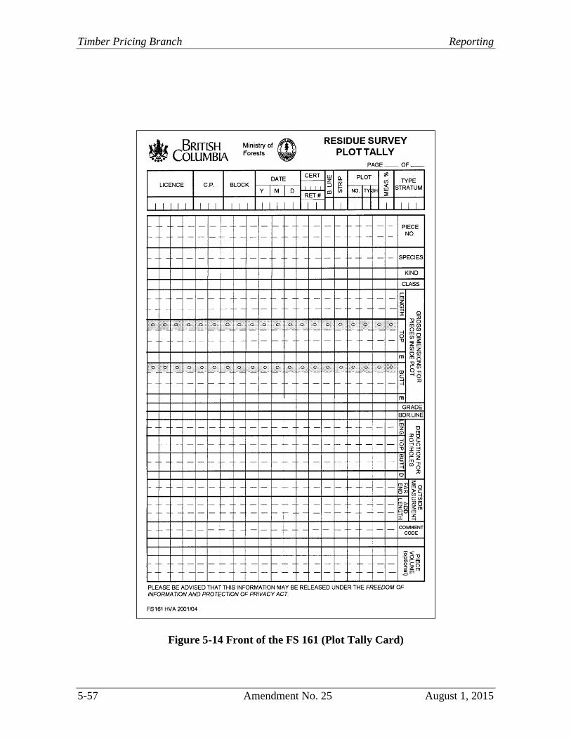
Timber Pricing Branch Reporting
5-57 Amendment No. 25 August 1, 2015
Figure 5-14 Front of the FS 161 (Plot Tally Card)
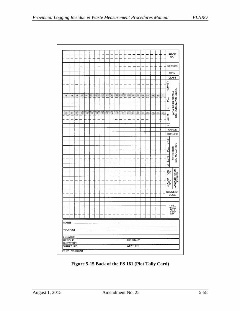
Provincial Logging Residue & Waste Measurement Procedures Manual FLNRO
August 1, 2015 Amendment No. 25 5-58
Figure 5-15 Back of the FS 161 (Plot Tally Card)