Embed Size (px)
Citation preview

© Crown copyright Met Office
Lightning Detection SystemsRoger Carter,
Spectrum Manager, UK Met Office
ITU/WMO SEMINAR ON USE OF RADIO SPECTRUM FOR METEOROLOGY.
16 – 18 September 2009

© Crown copyright Met Office
Lightning Detection Systems
Table of Contents
• Introduction to detection systems• Optical measurements from satellite [ +VHF?]
• Ground based observing systems, VLF/LF/VHF
• Examples of simultaneous observations
• Results of global climatology
• Introduction to UK ATDNET system
• Summary
© Crown copyright Met Office
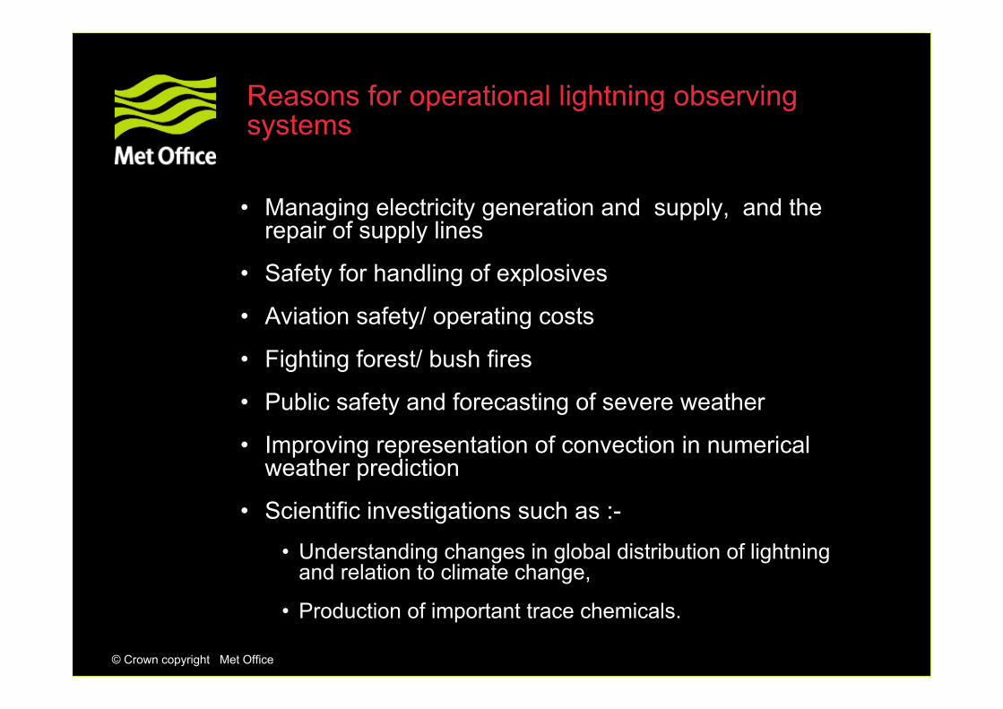
Reasons for operational lightning observing systems
• Managing electricity generation and supply, and the repair of supply lines
• Safety for handling of explosives
• Aviation safety/ operating costs
• Fighting forest/ bush fires
• Public safety and forecasting of severe weather
• Improving representation of convection in numerical weather prediction
• Scientific investigations such as :-
• Understanding changes in global distribution of lightning and relation to climate change,
• Production of important trace chemicals.

© Crown copyright Met Office
E
IC
CG
TLM technology combines :Dual Electromagnetic detection
VHF VHF for Total for Total lightninglightning detectiondetectionLFLF for CG for CG characterisationcharacterisation
TOTAL LIGHTNING MEASUREMENTS
Based on information from Vaisala Oy

© Crown copyright Met Office
Lightning Imaging System [LIS]on TRMM satellite [NASA/MSFC]
4 to 7 km resolution

© Crown copyright Met Office
Detection efficiency [DE]: 90 per cent day and night
DE specified as the probability of detecting a lightning event for the specified event energy range, where a lightning event is defined as a spatially uniform optical signal produced by an electric discharge, within or below clouds with the following mean characteristics:
Energy 4.0 to 400 μJ.m-2.sr-1; Spatial shape : Square of 10 km.Temporal width : 0.5 ms.
The occurrence of a lightning event is defined as any time the total signal from a given pixel exceeds the average signal for the pixel by a predetermined amount called the threshold.
The case when a random signal exceeds the threshold level with no lightning signal present is defined as a false alarm.
Typical specification for satellite lightning detection
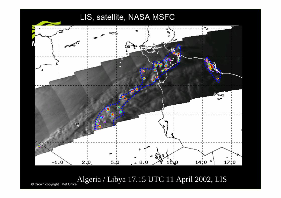
© Crown copyright Met OfficeAlgeria / Libya 17.15 UTC 11 April 2002, LIS
LIS, satellite, NASA MSFC
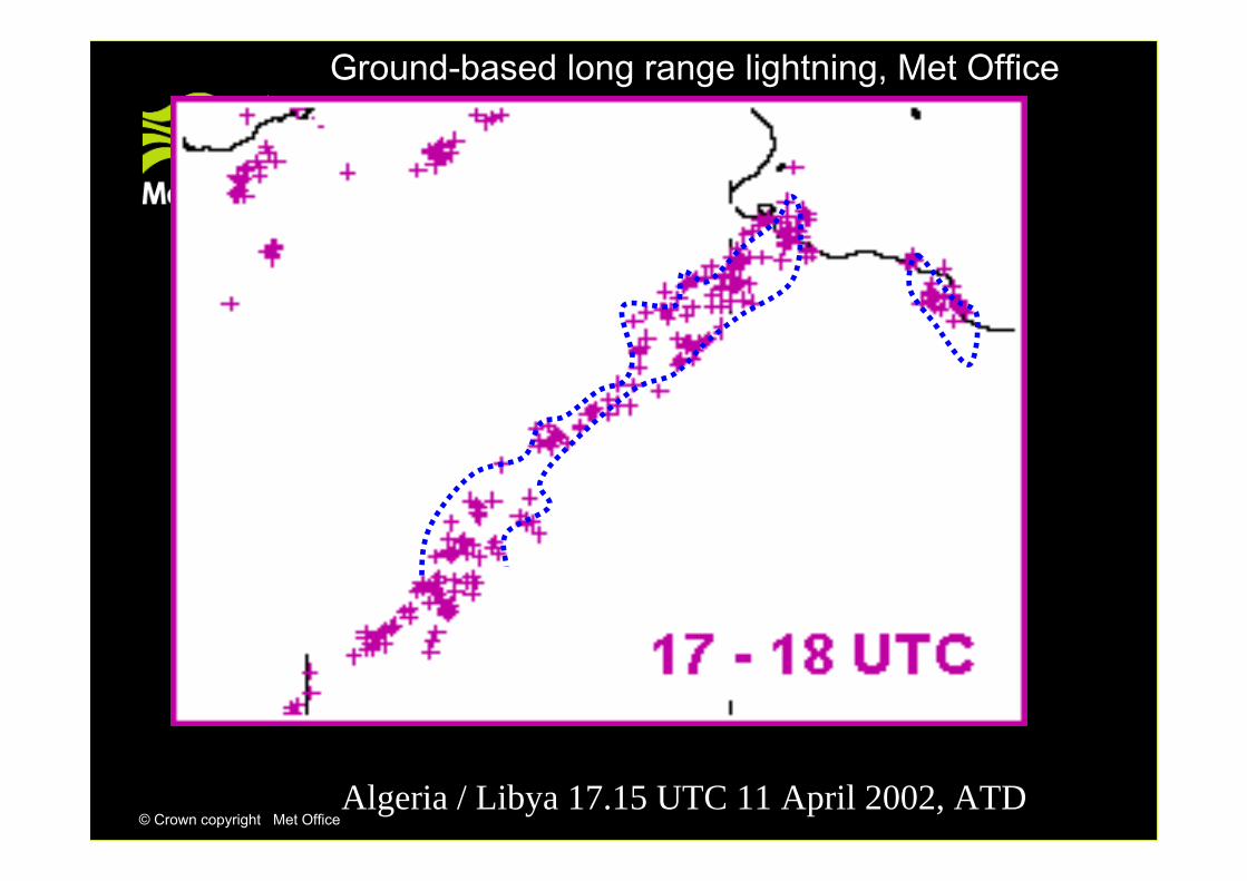
© Crown copyright Met OfficeAlgeria / Libya 17.15 UTC 11 April 2002, ATD
Ground-based long range lightning, Met Office
© Crown copyright Met Office
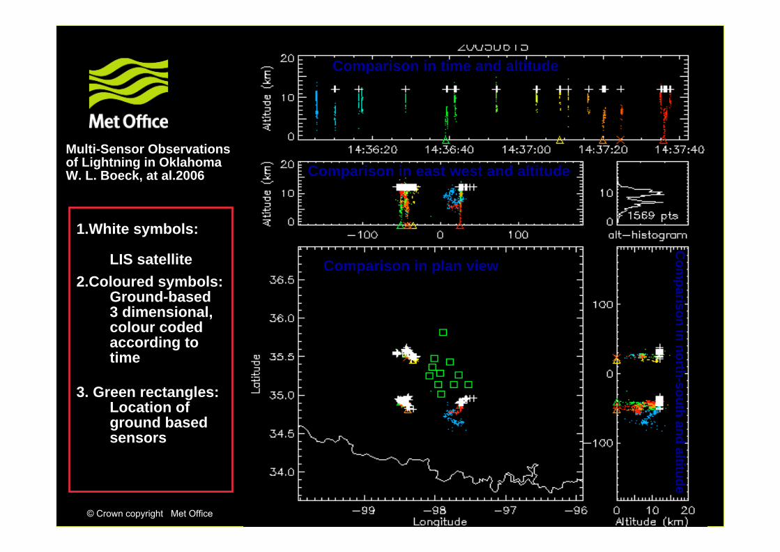
Multi-Sensor Observationsof Lightning in OklahomaW. L. Boeck, at al.2006
1.White symbols:
LIS satellite2.Coloured symbols:
Ground-based 3 dimensional, colour codedaccording to time
3. Green rectangles:Location of ground based sensors
Comparison in time and altitude
Comparison in plan view
Comparison in east west and altitude
Com
parison in north-south and altitude
© Crown copyright Met Office
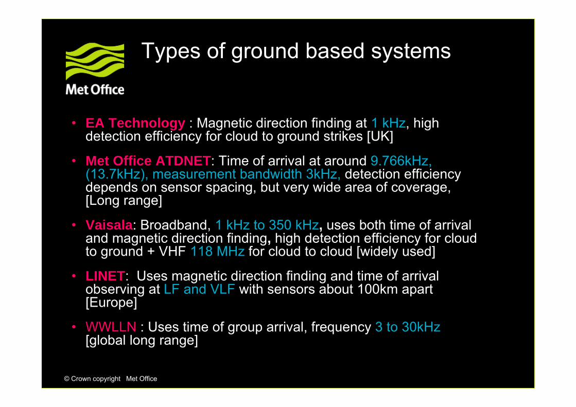
Types of ground based systems
• EA Technology : Magnetic direction finding at 1 kHz, high detection efficiency for cloud to ground strikes [UK]
• Met Office ATDNET: Time of arrival at around 9.766kHz, (13.7kHz), measurement bandwidth 3kHz, detection efficiency depends on sensor spacing, but very wide area of coverage, [Long range]
• Vaisala: Broadband, 1 kHz to 350 kHz, uses both time of arrival and magnetic direction finding, high detection efficiency for cloud to ground + VHF 118 MHz for cloud to cloud [widely used]
• LINET: Uses magnetic direction finding and time of arrival observing at LF and VLF with sensors about 100km apart [Europe]
• WWLLN : Uses time of group arrival, frequency 3 to 30kHz[global long range]

© Crown copyright Met Office
Specifications for ground based systems will be in terms of:
• Location accuracy, but usually will vary within a network given the condition of the sensors and their distribution
• Detection efficiency, strokes or flashes??
• What is minimum limit on size of discharge detectable, e.g. 20 kA
• More difficult to define for intra-cloud discharges
• Manufacturers recommend total lightning measurements, but not necessarily cheap
• False alarm rate
NOTE: Forecast model needed, since simple extrapolation in time and space does not cope well with the way thunderstorms develop.
© Crown copyright Met Office
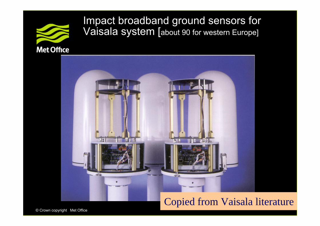
Impact broadband ground sensors for Vaisala system [about 90 for western Europe]
Copied from Vaisala literature
© Crown copyright Met Office
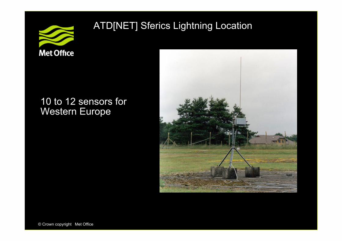
ATD[NET] Sferics Lightning Location
10 to 12 sensors forWestern Europe

© Crown copyright Met Office
WWLLN sensor locations.This network design currently gives best performance in
Australasia(from WWLLN website).
Observes radiation emitted between 3kHz and 30kHz

© Crown copyright Met Office
WWLLN 40 minute summary Prior to 11:10 UTC, 11 Sep 09
http://webflash.ess.washington.edu/TOGA_network_global_maps.htm

© Crown copyright Met Office
ATDnet 120 minute summary Prior to 1100 UTC, 11 Sep 09

© Crown copyright Met Office
ATDnet NOS locations (September 2009)Additionally, there is a NOS at La Réunion in the southern Indian Ocean and two
soon to be installed at Walvis Bay, Namibia and in Northern Croatia
© Crown copyright Met Office
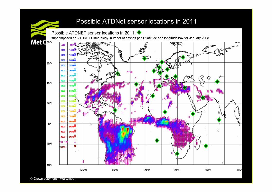
Possible ATDNet sensor locations in 2011

© Crown copyright Met Office
WWLLN: Yakutsk (From WWLLN website)

© Crown copyright Met Office
WWLLN: Sao Paulo (From WWLLN website)

© Crown copyright Met Office
WWLLN: Budapest (From WWLLN website)

© Crown copyright Met Office
Spectral plots between 6 and 20 kHz at Gibraltar, Akrotiri, Exeter, Lerwick, Nordeneyand Valentia ATD receiver locations

© Crown copyright Met Office
Signals received at Payerne outstation

© Crown copyright Met Office
Global climatology
-but how do you check stability of performance?

© Crown copyright Met Office
Annual climatology of WWLLN lightning locations for 2005, for >6 station locations
Mostly cloud to ground strokes
© Crown copyright Met Office
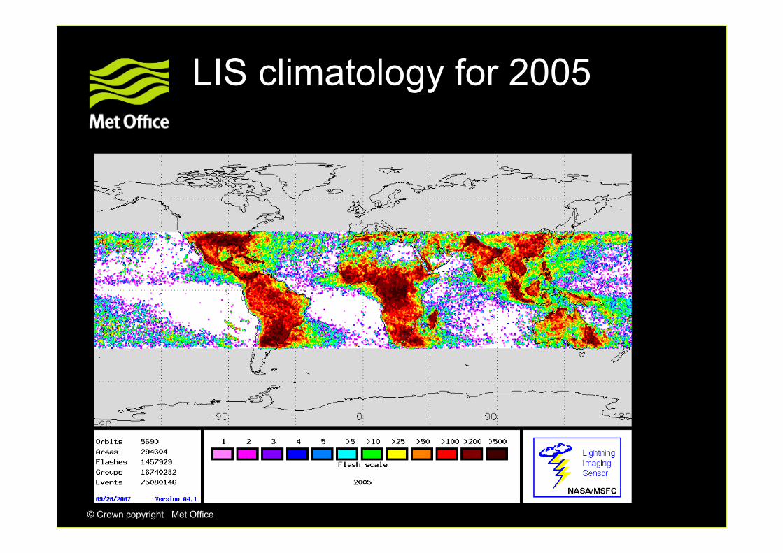
LIS climatology for 2005
© Crown copyright Met Office
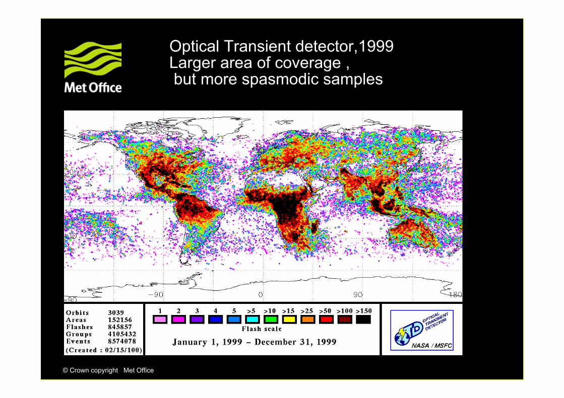
Optical Transient detector,1999Larger area of coverage ,but more spasmodic samples
© Crown copyright Met Office
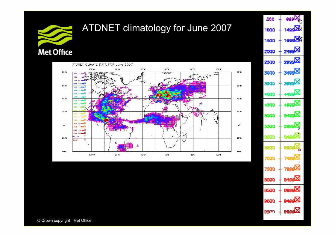
ATDNET climatology for June 2007

© Crown copyright Met Office
ATDNET climatology for September 2007

© Crown copyright Met Office
ATDNET climatology for November 2007
© Crown copyright Met Office
UK Met Office ATD system
© Crown copyright Met Office
UK Met Office ATD system
• Frequencies around 9 to 10 kHz used since 1939
• Originally as CRDF, but Arrival Time Difference since 1987
• At these frequencies the sky waves, reflected off the ionosphere, propagate for very large distances with relatively little attenuation and are preceded by a ground wave at shorter ranges.
• Thus, it is possible to receive the emissions from the cloud to ground strokes at thousands of kilometres from the stroke location.
• A distributed network of ground based sensors can locate the origin of the lightning stroke, using the time differences between the arrivals of the lightning emission at the individual sensor sites.

© Crown copyright Met Office
UK Met Office ATD system
• Currently 11 sensors, but there are plans to install more
• Monitoring in 2004 showed increasing levels of interference around the original centre frequency 9.766kHz so this was moved to 13.733kHz in 2007, but with some loss of performance. Measurement bandwidth 3kHz.
• This is a completely passive service
• No international recognition exists so far for use of these frequencies for lightning detection despite being used since 1939, as none seemed to be necessary until now, hence WRC-12 AI1.16.
• ATD has always co-existed with radionavigation services at these frequencies, with notch filters being used where necessary.

© Crown copyright Met Office
Arrival Time Difference fixing process
• Accurate time calibration - rubidium oscillators, checked by GPS
• Waveforms are Fourier analysed and sent to the central control station on request
• Waveforms from different outstations are correlated to estimate time differences
• Arrival Time Differences are then used to calculate lightning position by iterative method
• Distribution of data messages every five minutes
• Future Communications use VPN

© Crown copyright Met Office
24 August 15Z,2007

© Crown copyright Met Office
Current (Sep 2009) ATD system network coverage

© Crown copyright Met Office
© Crown copyright Met Office
Conclusions
• Satellite and ground based systems observe different activity in storms
• Identification of cloud to ground strikes is essential for safety operations and is best performed with ground based systems
• Relationship between thunderstorm activity and convection is complex ,as the significance of the ice phase in convection varies with each event
• The ratio of cloud to ground strokes to intracloud activity is probably different from sea to land.

© Crown copyright Met Office
Questions and answers

© Crown copyright Met Office
6 stations → 5 hyperbolae

© Crown copyright Met Office