Embed Size (px)
Citation preview
East Garrison Specific Plan - Draft Subsequent EIR Transportation and Circulation
Michael Brandman Associates 4.4-1 H:\Client (PN-JN)\2137\21370006\DSEIR\21370006_Sec04-04_Transpo.doc
4.4 TRANSPORTATION AND CIRCULATION The FORA Reuse Plan Final Environmental Impact Report (FORA FEIR) identified on a program level potentially significant environmental impacts for transportation as related to increased travel demand on the regional transportation system. The FORA FEIR also identified less than significant impacts due to increased travel demand within FFO and increased demand for transit.
Site specific details and project-level information for the EGSP project was not known and not analyzed at the time of the FORA FEIR. New information between the time the FORA FEIR was certified and the release of the Notice of Preparation (NOP) for the currently proposed EGSP project includes changes in proposed land use types and intensity on the project site; development of a project-specific site plan; development of an onsite circulation, public transportation, pedestrian, and bicycle facilities plans; a parking plan, and the preparation of a project-specific traffic impact analysis for the EGSP project. In addition, traffic in region and project area has grown since the FORA FEIR, necessitating the use of updated traffic modeling information.
This section provides additional analysis of potential impacts not previously analyzed in the FORA FEIR and is based on information contained in the Traffic Impact Study for East Garrison Development in Monterey County prepared in September 2004 by TJKM Transportation Consultants under contract with Monterey County. This section provides information regarding existing roadways and traffic conditions in the East Garrison Specific Plan (EGSP) project area, analysis of potential impacts to intersections and roadways resulting from the project, and recommended mitigation measures. The Traffic Impact Study is included in Appendix E of this DSEIR.
4.4.1 Environmental Setting EXISTING ROADWAY SYSTEM
Reservation Road
Reservation Road is a major east-west two- to four-lane arterial, extending westerly from Marina State Beach to State Route (SR) 68. This road has variable speed limits ranging from 35 miles per hour (mph) in the city, to 65 mph east of Blanco Road. Reservation Road is fronted by business and commercial centers and a few residential developments from Del Monte Boulevard to Seacrest Avenue, and open space and farmlands east of Imjin Parkway to Davis Road.
Cyclists are allowed access to Inter-Garrison Road through the small gate opening. Adequately spaced transit bus stops were observed on both sides of Reservation Road. Monterey-Salinas Transit and school buses use Reservation Road.
The relatively low vertical grades and horizontal alignments of Reservation Road segments provide good sight distance to motorists. Sight distance of more than 1000 feet was observed for most roadway segments with speeds up to 55 mph. However, a substantial vertical curve exists east of the proposed main entrance to the project (i.e., Main Project Access) which somewhat reduces sight distance.
Del Monte Boulevard
Del Monte Boulevard is a north-south four-lane arterial that carries heavy traffic volumes to and from Reservation Road during the morning and afternoon peak periods. Del Monte Boulevard is fronted on the east by small business and commercial properties and on the west by recreational trails and parks. Monterey-Salinas Transit operates on Del Monte Boulevard.
Transportation and Circulation East Garrison Specific Plan - Draft Subsequent EIR
4.4-2 Michael Brandman Associates H:\Client (PN-JN)\2137\21370006\DSEIR\21370006_Sec04-04_Transpo.doc
Vista Del Camino
Vista Del Camino is a two-lane roadway that forms a “T” intersection with Reservation Road just east of Del Monte Boulevard in the City of Marina. Land uses along Vista Del Camino are mainly residential and commercial.
Seacrest Avenue and Crescent Avenue
Seacrest Avenue and Crescent Avenue are two-lane roadways with adjacent residential and commercial land uses. Both Seacrest Avenue and Crescent Avenue intersect Reservation Road (east of Vista Del Camino) in the City of Marina.
Imjin Parkway
Imjin Parkway is bounded on the north by the University of California-Monterey Bay Education, Science, and Technology Center (UCMBEST) facility. To the south, Imjin Parkway connects with 12th Street, which has a new connection with State Route (SR) 1. This new 12th Street/SR 1 interchange together with Imjin Parkway is being used by Salinas-Monterey Peninsula commuters that previously used Reservation Road through the City of Marina.
Blanco Road and Davis Road
Blanco Road and Davis Road are two-lane rural roadways that provide access between the cities of Salinas and Marina. Land uses fronting the two corridors consist of farmlands and open space.
Light Fighter Drive
Light Fighter Drive serves as a major four-lane collector street carrying moderate traffic to and from CSUMB and the surrounding land uses. It also serves the main former Fort Ord entrance off SR 1. The posted speed limit is 35 mph.
General Jim Moore Boulevard
General Jim Moore Boulevard is an undulating two-lane roadway bounded on the north by Light Fighter Drive and on the south by Canyon Del Rey Boulevard. The posted speed limit varies from 35 mph to 45 mph. General Jim Moore Boulevard is fronted on the west by a few residential properties and on the east by open space and carries a moderate amount of traffic.
Monterey-Salinas Highway (State Route 68)
Monterey-Salinas Highway (SR 68) provides access between Monterey (where it connects with SR 1) and Salinas. SR 68 is heavily used by commuters who typically live in the Salinas area and work in the Monterey Peninsula.
Canyon Del Rey Boulevard (State Route 218)
Canyon Del Rey Boulevard (SR 218) is bounded on the north by SR 1 and merges into SR 68 on the south. The roadway provides access to Monterey County cities and is fronted by recreational parks and sparse residential developments.
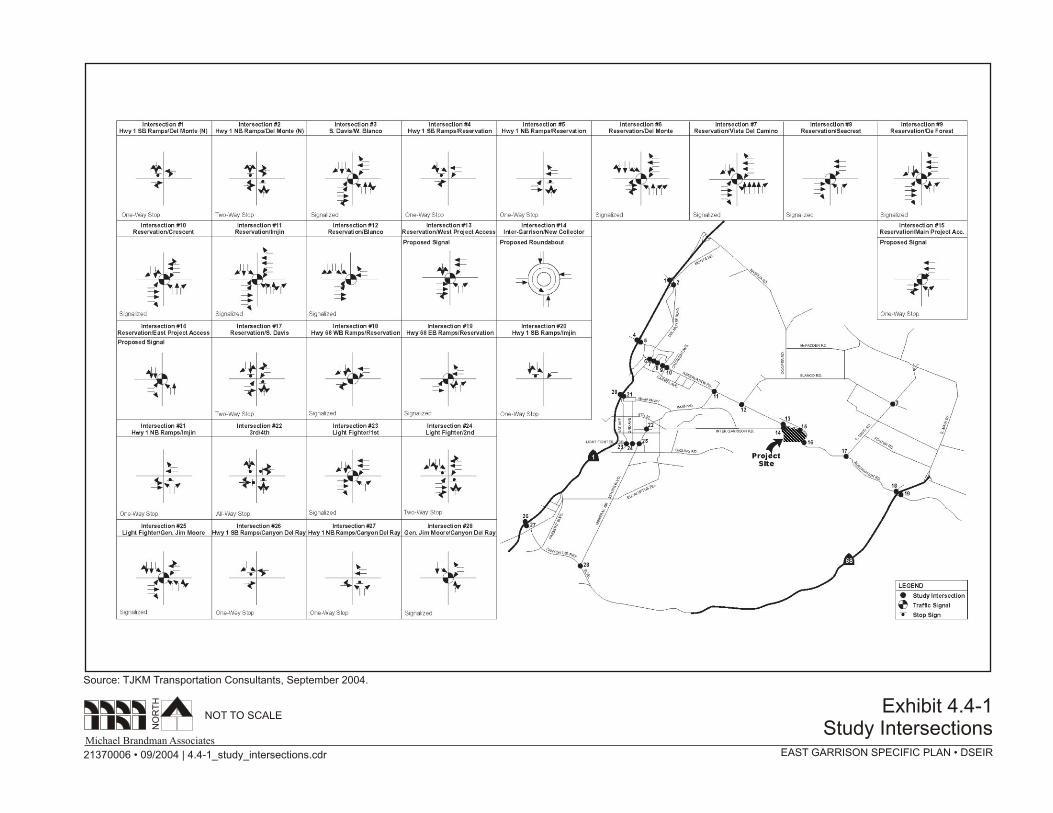
STUDY INTERSECTIONS
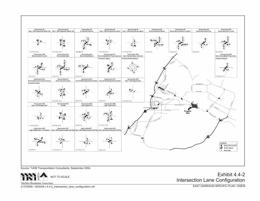
The study evaluated conditions at 28 intersections in the project area that could be potentially impacted by the proposed project. Study intersections are listed in Table 4.4-1 and shown in Exhibit 4.4-1.

East Garrison Specific Plan - Draft Subsequent EIR Transportation and Circulation
Michael Brandman Associates 4.4-5 H:\Client (PN-JN)\2137\21370006\DSEIR\21370006_Sec04-04_Transpo.doc
Table 4.4-1: Study Intersections
Intersection Signalized Unsignalized
SR 1 Southbound Ramps/Del Monte Boulevard
SR 1 Northbound Ramps/Del Monte Boulevard
Davis Road/t Blanco Road
SR 1 Southbound Ramps/Reservation Road
SR 1 Northbound Ramps/Reservation Road
Reservation Road/Del Monte Boulevard
Reservation Road/Vista Del Camino
Reservation Road/Seacrest Avenue
Reservation Road/De Forest Road
Reservation Road/Crescent Avenue
Reservation Road/Imjin Parkway
Reservation Road/Blanco Road
Reservation Road/Western Project Access1
Inter-Garrison Road/New Collector, connects with Reservation Road2
Reservation Road/Central (Main) Project Access1
Reservation Road/Eastern Project Access1
Reservation Road/ Davis Road/Driveway to The Bluffs
SR 68 Westbound Ramps/Reservation Road
SR 68 Eastbound Ramps/Reservation Road
SR 1 Southbound Ramps/Imjin Parkway
SR 1 Northbound Ramps/Imjin Parkway
3rd Street/4th Avenue
Light Fighter Drive/1st Avenue
Light Fighter Drive/2nd Avenue
Light Fighter Drive/General Jim Moore Boulevard
SR 1 Southbound Ramps/ Canyon Del Rey Boulevard
SR 1 Northbound Ramps/Canyon Del Rey Boulevard
General Jim Moore Boulevard/Canyon Del Rey Boulevard 1 Future intersection. 2 Future roundabout. Source: TJKM Transportation Consultants, September 2004.
LEVEL OF SERVICE ANALYSIS METHODOLOGY
Level of service (LOS) is a qualitative measure describing operational conditions as they relate to the traffic stream and perceptions by motorists and passengers. LOS generally describes these conditions
Transportation and Circulation East Garrison Specific Plan - Draft Subsequent EIR
4.4-6 Michael Brandman Associates H:\Client (PN-JN)\2137\21370006\DSEIR\21370006_Sec04-04_Transpo.doc
in terms of speed, travel time, delays, freedom to maneuver, traffic interruptions, comfort, convenience, and safety.
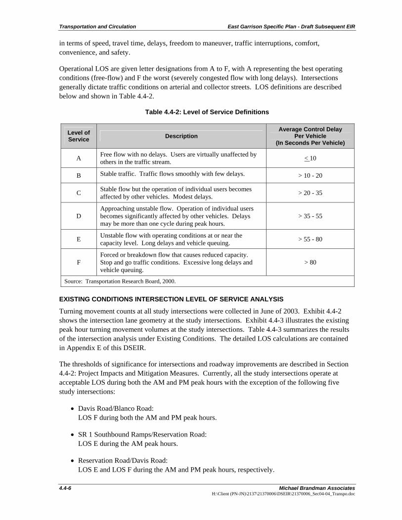
Operational LOS are given letter designations from A to F, with A representing the best operating conditions (free-flow) and F the worst (severely congested flow with long delays). Intersections generally dictate traffic conditions on arterial and collector streets. LOS definitions are described below and shown in Table 4.4-2.
Table 4.4-2: Level of Service Definitions
Level of Service Description
Average Control Delay Per Vehicle
(In Seconds Per Vehicle)
A Free flow with no delays. Users are virtually unaffected by others in the traffic stream. < 10
B Stable traffic. Traffic flows smoothly with few delays. > 10 - 20
C Stable flow but the operation of individual users becomes affected by other vehicles. Modest delays. > 20 - 35
D Approaching unstable flow. Operation of individual users becomes significantly affected by other vehicles. Delays may be more than one cycle during peak hours.
> 35 - 55
E Unstable flow with operating conditions at or near the capacity level. Long delays and vehicle queuing. > 55 - 80
F Forced or breakdown flow that causes reduced capacity. Stop and go traffic conditions. Excessive long delays and vehicle queuing.
> 80
Source: Transportation Research Board, 2000.
EXISTING CONDITIONS INTERSECTION LEVEL OF SERVICE ANALYSIS
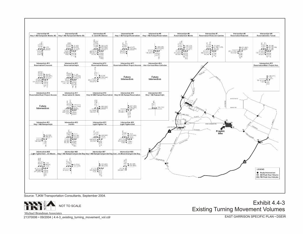
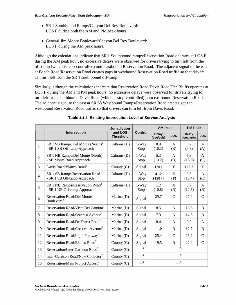
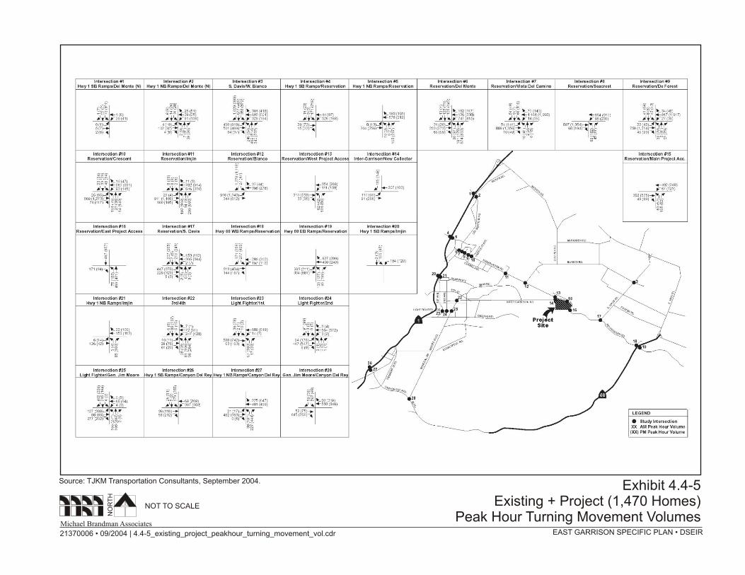
Turning movement counts at all study intersections were collected in June of 2003. Exhibit 4.4-2 shows the intersection lane geometry at the study intersections. Exhibit 4.4-3 illustrates the existing peak hour turning movement volumes at the study intersections. Table 4.4-3 summarizes the results of the intersection analysis under Existing Conditions. The detailed LOS calculations are contained in Appendix E of this DSEIR.
The thresholds of significance for intersections and roadway improvements are described in Section 4.4-2: Project Impacts and Mitigation Measures. Currently, all the study intersections operate at acceptable LOS during both the AM and PM peak hours with the exception of the following five study intersections:
• Davis Road/Blanco Road: LOS F during both the AM and PM peak hours.
• SR 1 Southbound Ramps/Reservation Road: LOS E during the AM peak hours.
• Reservation Road/Davis Road: LOS E and LOS F during the AM and PM peak hours, respectively.


East Garrison Specific Plan - Draft Subsequent EIR Transportation and Circulation
Michael Brandman Associates 4.4-11 H:\Client (PN-JN)\2137\21370006\DSEIR\21370006_Sec04-04_Transpo.doc
• SR 1 Southbound Ramps/Canyon Del Rey Boulevard: LOS F during both the AM and PM peak hours.
• General Jim Moore Boulevard/Canyon Del Rey Boulevard: LOS F during the AM peak hours.
Although the calculations indicate that SR 1 Southbound ramps/Reservation Road operates at LOS F during the AM peak hour, no excessive delays were observed for drivers trying to turn left from the off-ramp (which is stop-controlled) onto eastbound Reservation Road. The adjacent signal to the east at Beach Road/Reservation Road creates gaps in westbound Reservation Road traffic so that drivers can turn left from the SR 1 southbound off-ramp.
Similarly, although the calculations indicate that Reservation Road/Davis Road/The Bluffs operates at LOS F during the AM and PM peak hours, no excessive delays were observed for drivers trying to turn left from southbound Davis Road (which is stop-controlled) onto eastbound Reservation Road. The adjacent signal to the east at SR 68 Westbound Ramps/Reservation Road creates gaps in westbound Reservation Road traffic so that drivers can turn left from Davis Road.
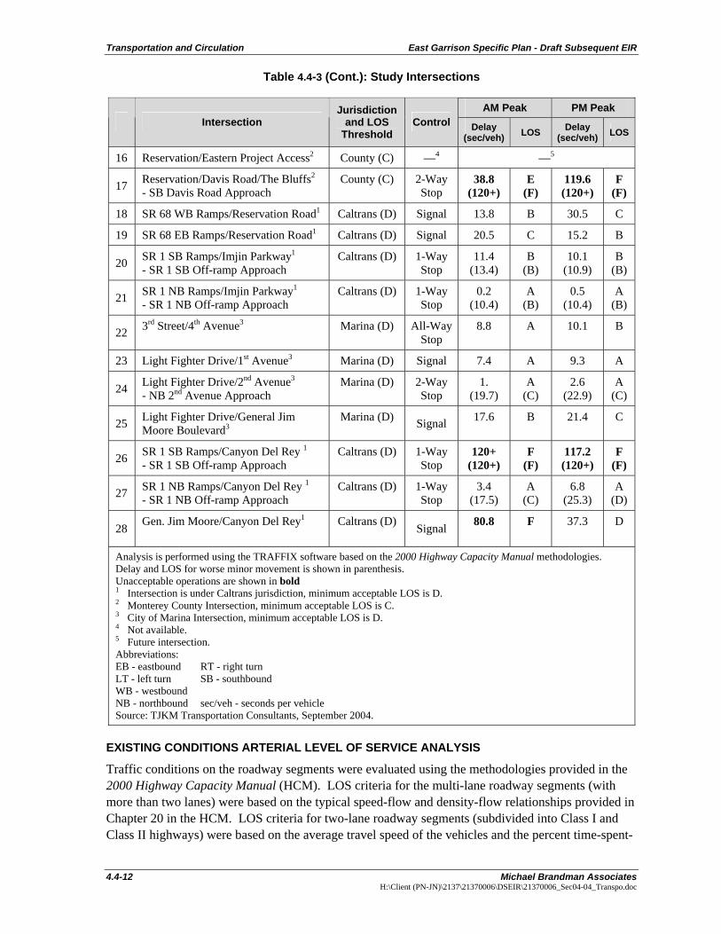
Table 4.4-3: Existing Intersection Level of Service Analysis
AM Peak PM Peak Intersection
Jurisdictionand LOS
Threshold Control Delay
(sec/veh) LOS Delay (sec/veh) LOS
1 SR 1 SB Ramps/Del Monte (North)1
- SR 1 SB Off-ramp Approach Caltrans (D) 1-Way
Stop 8.9
(10.3) A
(B) 8.2
(9.8) A
(A)
2 SR 1 NB Ramps/Del Monte (North)1
- SB Monte Road Approach Caltrans (D) 1-Way
Stop 5.3
(13.2) A
(B) 6.3
(16.5) A
(C)
3 Davis Road/Blanco Road2 County (C) Signal 120+ F 102.3 F
4 SR 1 SB Ramps/Reservation Road1
- SR 1 SB Off-ramp Approach Caltrans (D) 1-Way
Stop 41.2
(120+) E
(F) 9.6
(18.4) A
(C)
5 SR 1 NB Ramps/Reservation Road1
- SR 1 NB Off-ramp Approach Caltrans (D) 1-Way
Stop 1.2
(10.8) A
(B) 3.7
(12.3) A
(B)
6 Reservation Road/Del Monte Boulevard3
Marina (D) Signal 25.7 C 27.4 C
7 Reservation Road/Vista Del Camino3 Marina (D) Signal 8.5 A 13.6 B
8 Reservation Road/Seacrest Avenue3 Marina (D) Signal 7.9 A 14.6 B
9 Reservation Road/De Forest Road3 Marina (D) Signal 8.4 A 9.8 A
10 Reservation Road/Crescent Avenue3 Marina (D) Signal 11.0 B 12.7 B
11 Reservation Road/Imjin Parkway3 Marina (D) Signal 25.4 C 28.2 C
12 Reservation Road/Blanco Road2 County (C) Signal 19.5 B 22.4 C
13 Reservation/Inter-Garrison Road2 County (C) —4 —5
14 Inter-Garrison Road/New Collector2 County (C) —4 —5
15 Reservation/Main Project Access2 County (C) —4 —5
Transportation and Circulation East Garrison Specific Plan - Draft Subsequent EIR
4.4-12 Michael Brandman Associates H:\Client (PN-JN)\2137\21370006\DSEIR\21370006_Sec04-04_Transpo.doc
Table 4.4-3 (Cont.): Study Intersections
AM Peak PM Peak Intersection
Jurisdictionand LOS
Threshold Control Delay
(sec/veh) LOS Delay (sec/veh) LOS
16 Reservation/Eastern Project Access2 County (C) —4 —5
17 Reservation/Davis Road/The Bluffs2
- SB Davis Road Approach County (C) 2-Way
Stop 38.8
(120+) E
(F) 119.6 (120+)
F (F)
18 SR 68 WB Ramps/Reservation Road1 Caltrans (D) Signal 13.8 B 30.5 C
19 SR 68 EB Ramps/Reservation Road1 Caltrans (D) Signal 20.5 C 15.2 B
20 SR 1 SB Ramps/Imjin Parkway1
- SR 1 SB Off-ramp Approach Caltrans (D) 1-Way
Stop 11.4
(13.4) B
(B) 10.1
(10.9) B
(B)
21 SR 1 NB Ramps/Imjin Parkway1
- SR 1 NB Off-ramp Approach Caltrans (D) 1-Way
Stop 0.2
(10.4) A
(B) 0.5
(10.4) A
(B)
22 3rd Street/4th Avenue3 Marina (D) All-Way Stop
8.8 A 10.1 B
23 Light Fighter Drive/1st Avenue3 Marina (D) Signal 7.4 A 9.3 A
24 Light Fighter Drive/2nd Avenue3
- NB 2nd Avenue Approach Marina (D) 2-Way
Stop 1.
(19.7) A
(C) 2.6
(22.9) A
(C)
25 Light Fighter Drive/General Jim Moore Boulevard3
Marina (D) Signal 17.6 B 21.4 C
26 SR 1 SB Ramps/Canyon Del Rey 1
- SR 1 SB Off-ramp Approach Caltrans (D) 1-Way
Stop 120+
(120+) F
(F) 117.2 (120+)
F (F)
27 SR 1 NB Ramps/Canyon Del Rey 1
- SR 1 NB Off-ramp Approach Caltrans (D) 1-Way
Stop 3.4
(17.5) A
(C) 6.8
(25.3) A
(D)
28 Gen. Jim Moore/Canyon Del Rey1 Caltrans (D) Signal 80.8 F 37.3 D
Analysis is performed using the TRAFFIX software based on the 2000 Highway Capacity Manual methodologies. Delay and LOS for worse minor movement is shown in parenthesis. Unacceptable operations are shown in bold 1 Intersection is under Caltrans jurisdiction, minimum acceptable LOS is D. 2 Monterey County Intersection, minimum acceptable LOS is C. 3 City of Marina Intersection, minimum acceptable LOS is D. 4 Not available. 5 Future intersection. Abbreviations: EB - eastbound RT - right turn LT - left turn SB - southbound WB - westbound NB - northbound sec/veh - seconds per vehicle Source: TJKM Transportation Consultants, September 2004.
EXISTING CONDITIONS ARTERIAL LEVEL OF SERVICE ANALYSIS
Traffic conditions on the roadway segments were evaluated using the methodologies provided in the 2000 Highway Capacity Manual (HCM). LOS criteria for the multi-lane roadway segments (with more than two lanes) were based on the typical speed-flow and density-flow relationships provided in Chapter 20 in the HCM. LOS criteria for two-lane roadway segments (subdivided into Class I and Class II highways) were based on the average travel speed of the vehicles and the percent time-spent-
East Garrison Specific Plan - Draft Subsequent EIR Transportation and Circulation
Michael Brandman Associates 4.4-13 H:\Client (PN-JN)\2137\21370006\DSEIR\21370006_Sec04-04_Transpo.doc
following. Class I highways are two-lane highways that are considered major intercity routes, primary arterials connecting major traffic generators, daily commuter routes, or primary links in state or national highway networks. The motorists are expected to travel at relatively high speeds on Class I highways. Class II highways are considered access routes to Class I facilities, serve as scenic or recreational routes that are not primary arterials, or pass through rugged terrain. The motorists are not necessarily expected to travel at high speeds on Class II highways. For Class I highways, where mobility is paramount, LOS is defined in terms of both average travel speed and percent time-spent-following. The Traffic Impact Study in Appendix E of this DSEIR contains the segment LOS analysis results.
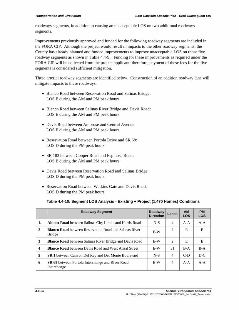
The study evaluated conditions for roadway segments in the project area that could be potentially impacted by the proposed project. Table 4.4-4 lists the roadway segments analyzed under existing conditions. As shown on Exhibit 4.4-4 and Table 4.4-4, the following roadway segments currently operate at unacceptable LOS under existing conditions:
• Blanco Road between Reservation Road and Salinas River Bridge (segment 2): LOS E during the AM and PM peak hours.
• Blanco Road between Salinas River Bridge and Davis Road (segment 3): LOS E during the AM and PM peak hours.
• Davis Road between Ambrose Avenue and Central Avenue (segment 21): LOS E during the AM and PM peak hours.
• Reservation Road between Portola Drive and SR 68 (segment 24): LOS D during the PM peak hours.
• SR 183 between Cooper Road and Espinosa Road (segment 26): LOS E during the PM peak hours.
Table 4.4-4: Segment Level of Service Analysis - Existing Conditions
Roadway Segment Jurisdiction
and LOS Threshold
Road-way
Direction Lanes AM
LOS PM
LOS
1 Abbott between (b/w) Salinas City Limits and Harris Salinas (D) N-S 4 A-A A-A
2. Blanco Road b/w Reservation and Salinas River Bridge
County (C) E-W 2 E E
3 Blanco Road b/w Salinas River Bridge and Davis Road
County (C) E-W 2 E E
4 Blanco Road b/w Davis Road and West Alisal Marina (D) E-W 3 (a) B-A B-A
5 SR 1 b/w Canyon Del Rey and Del Monte Caltrans (D) N-S 4 C-D D-C
6 SR 68 b/w Portola & River Road Interchanges Caltrans (D) E-W 4 A-A A-A
7 Reservation Road b/w Imjin and Blanco Marina (D) E-W 4 B-B B-B
8 Imjin Parkway b/w Preston Park and Abrams Marina (D) E-W 4 A-A A-A
9 West Laurel Drive between US 101 and Davis Road Marina (D) E-W 6 B-B B-B
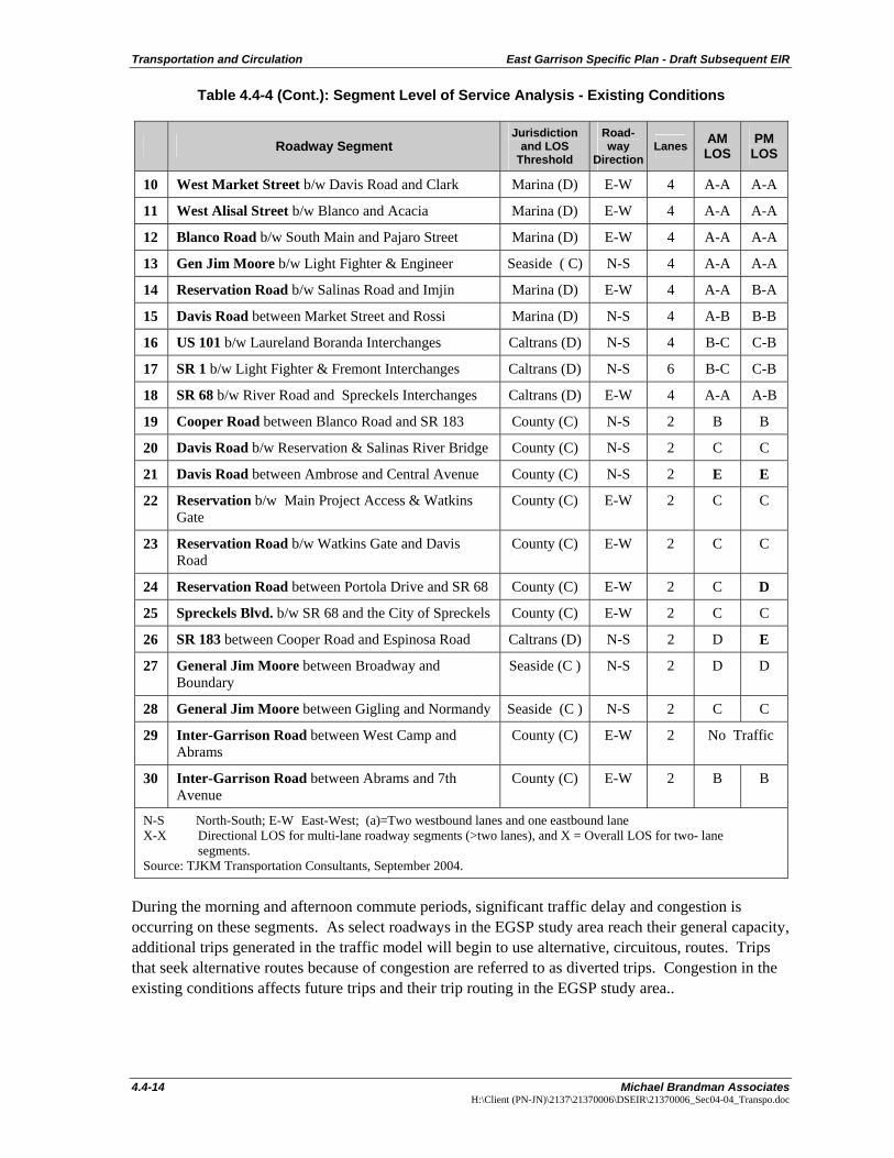
Transportation and Circulation East Garrison Specific Plan - Draft Subsequent EIR
4.4-14 Michael Brandman Associates H:\Client (PN-JN)\2137\21370006\DSEIR\21370006_Sec04-04_Transpo.doc
Table 4.4-4 (Cont.): Segment Level of Service Analysis - Existing Conditions
Roadway Segment Jurisdiction
and LOS Threshold
Road-way
Direction Lanes AM
LOS PM
LOS
10 West Market Street b/w Davis Road and Clark Marina (D) E-W 4 A-A A-A
11 West Alisal Street b/w Blanco and Acacia Marina (D) E-W 4 A-A A-A
12 Blanco Road b/w South Main and Pajaro Street Marina (D) E-W 4 A-A A-A
13 Gen Jim Moore b/w Light Fighter & Engineer Seaside ( C) N-S 4 A-A A-A
14 Reservation Road b/w Salinas Road and Imjin Marina (D) E-W 4 A-A B-A
15 Davis Road between Market Street and Rossi Marina (D) N-S 4 A-B B-B
16 US 101 b/w Laureland Boranda Interchanges Caltrans (D) N-S 4 B-C C-B
17 SR 1 b/w Light Fighter & Fremont Interchanges Caltrans (D) N-S 6 B-C C-B
18 SR 68 b/w River Road and Spreckels Interchanges Caltrans (D) E-W 4 A-A A-B
19 Cooper Road between Blanco Road and SR 183 County (C) N-S 2 B B
20 Davis Road b/w Reservation & Salinas River Bridge County (C) N-S 2 C C
21 Davis Road between Ambrose and Central Avenue County (C) N-S 2 E E
22 Reservation b/w Main Project Access & Watkins Gate
County (C) E-W 2 C C
23 Reservation Road b/w Watkins Gate and Davis Road
County (C) E-W 2 C C
24 Reservation Road between Portola Drive and SR 68 County (C) E-W 2 C D
25 Spreckels Blvd. b/w SR 68 and the City of Spreckels County (C) E-W 2 C C
26 SR 183 between Cooper Road and Espinosa Road Caltrans (D) N-S 2 D E
27 General Jim Moore between Broadway and Boundary
Seaside (C ) N-S 2 D D
28 General Jim Moore between Gigling and Normandy Seaside (C ) N-S 2 C C
29 Inter-Garrison Road between West Camp and Abrams
County (C) E-W 2 No Traffic
30 Inter-Garrison Road between Abrams and 7th Avenue
County (C) E-W 2 B B
N-S North-South; E-W East-West; (a)=Two westbound lanes and one eastbound lane X-X Directional LOS for multi-lane roadway segments (>two lanes), and X = Overall LOS for two- lane
segments. Source: TJKM Transportation Consultants, September 2004.
During the morning and afternoon commute periods, significant traffic delay and congestion is occurring on these segments. As select roadways in the EGSP study area reach their general capacity, additional trips generated in the traffic model will begin to use alternative, circuitous, routes. Trips that seek alternative routes because of congestion are referred to as diverted trips. Congestion in the existing conditions affects future trips and their trip routing in the EGSP study area..


East Garrison Specific Plan - Draft Subsequent EIR Transportation and Circulation
Michael Brandman Associates 4.4-17 H:\Client (PN-JN)\2137\21370006\DSEIR\21370006_Sec04-04_Transpo.doc
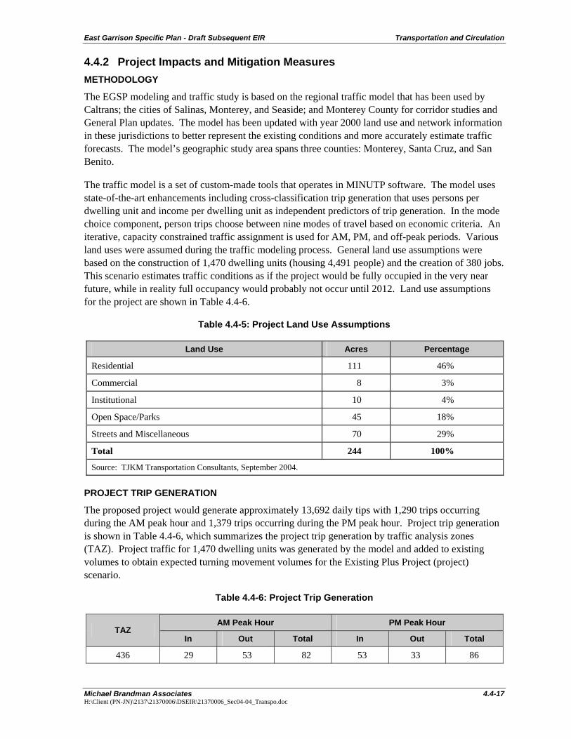
4.4.2 Project Impacts and Mitigation Measures METHODOLOGY
The EGSP modeling and traffic study is based on the regional traffic model that has been used by Caltrans; the cities of Salinas, Monterey, and Seaside; and Monterey County for corridor studies and General Plan updates. The model has been updated with year 2000 land use and network information in these jurisdictions to better represent the existing conditions and more accurately estimate traffic forecasts. The model’s geographic study area spans three counties: Monterey, Santa Cruz, and San Benito.
The traffic model is a set of custom-made tools that operates in MINUTP software. The model uses state-of-the-art enhancements including cross-classification trip generation that uses persons per dwelling unit and income per dwelling unit as independent predictors of trip generation. In the mode choice component, person trips choose between nine modes of travel based on economic criteria. An iterative, capacity constrained traffic assignment is used for AM, PM, and off-peak periods. Various land uses were assumed during the traffic modeling process. General land use assumptions were based on the construction of 1,470 dwelling units (housing 4,491 people) and the creation of 380 jobs. This scenario estimates traffic conditions as if the project would be fully occupied in the very near future, while in reality full occupancy would probably not occur until 2012. Land use assumptions for the project are shown in Table 4.4-6.
Table 4.4-5: Project Land Use Assumptions
Land Use Acres Percentage
Residential 111 46%
Commercial 8 3%
Institutional 10 4%
Open Space/Parks 45 18%
Streets and Miscellaneous 70 29%
Total 244 100%
Source: TJKM Transportation Consultants, September 2004. PROJECT TRIP GENERATION
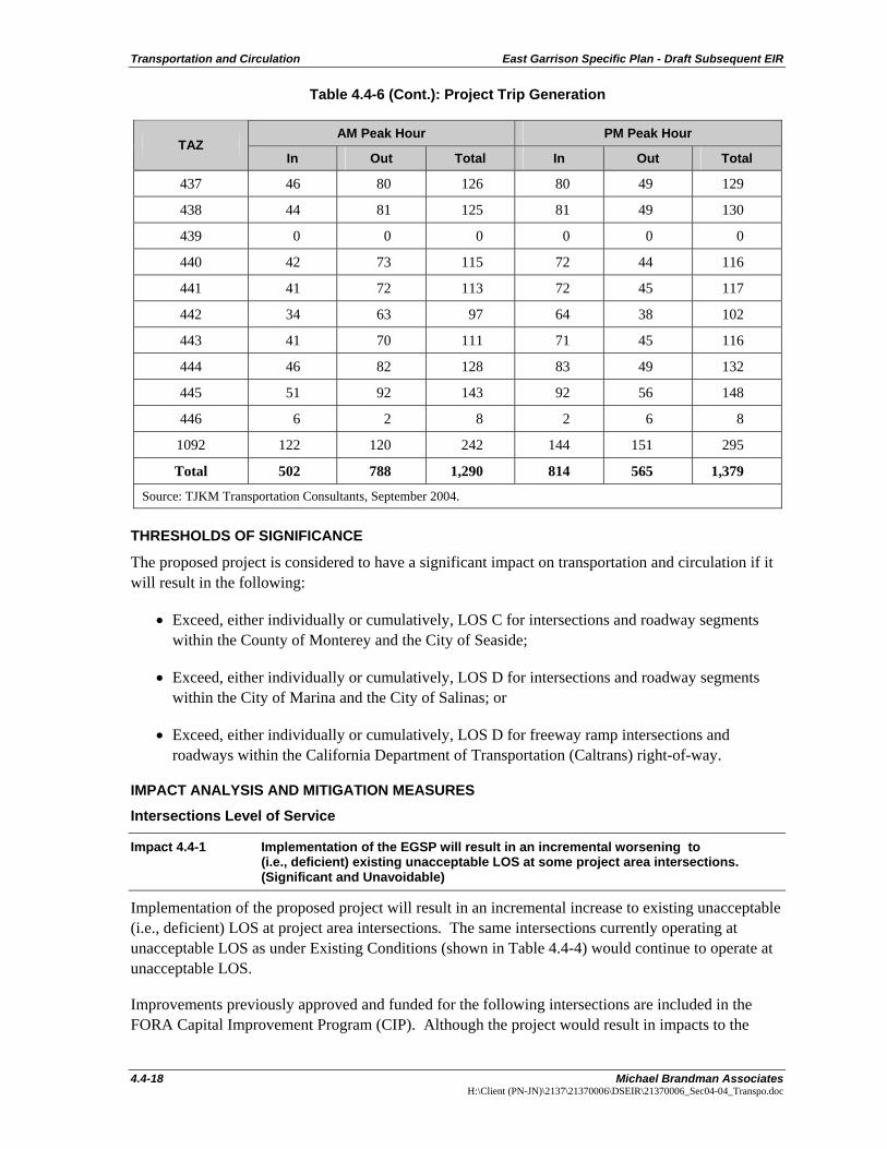
The proposed project would generate approximately 13,692 daily tips with 1,290 trips occurring during the AM peak hour and 1,379 trips occurring during the PM peak hour. Project trip generation is shown in Table 4.4-6, which summarizes the project trip generation by traffic analysis zones (TAZ). Project traffic for 1,470 dwelling units was generated by the model and added to existing volumes to obtain expected turning movement volumes for the Existing Plus Project (project) scenario.
Table 4.4-6: Project Trip Generation
AM Peak Hour PM Peak Hour TAZ
In Out Total In Out Total
436 29 53 82 53 33 86
Transportation and Circulation East Garrison Specific Plan - Draft Subsequent EIR
4.4-18 Michael Brandman Associates H:\Client (PN-JN)\2137\21370006\DSEIR\21370006_Sec04-04_Transpo.doc
Table 4.4-6 (Cont.): Project Trip Generation
AM Peak Hour PM Peak Hour TAZ
In Out Total In Out Total
437 46 80 126 80 49 129
438 44 81 125 81 49 130
439 0 0 0 0 0 0
440 42 73 115 72 44 116
441 41 72 113 72 45 117
442 34 63 97 64 38 102
443 41 70 111 71 45 116
444 46 82 128 83 49 132
445 51 92 143 92 56 148
446 6 2 8 2 6 8
1092 122 120 242 144 151 295
Total 502 788 1,290 814 565 1,379
Source: TJKM Transportation Consultants, September 2004.
THRESHOLDS OF SIGNIFICANCE
The proposed project is considered to have a significant impact on transportation and circulation if it will result in the following:
• Exceed, either individually or cumulatively, LOS C for intersections and roadway segments within the County of Monterey and the City of Seaside;
• Exceed, either individually or cumulatively, LOS D for intersections and roadway segments within the City of Marina and the City of Salinas; or
• Exceed, either individually or cumulatively, LOS D for freeway ramp intersections and roadways within the California Department of Transportation (Caltrans) right-of-way.
IMPACT ANALYSIS AND MITIGATION MEASURES
Intersections Level of Service
Impact 4.4-1 Implementation of the EGSP will result in an incremental worsening to (i.e., deficient) existing unacceptable LOS at some project area intersections. (Significant and Unavoidable)
Implementation of the proposed project will result in an incremental increase to existing unacceptable (i.e., deficient) LOS at project area intersections. The same intersections currently operating at unacceptable LOS as under Existing Conditions (shown in Table 4.4-4) would continue to operate at unacceptable LOS.
Improvements previously approved and funded for the following intersections are included in the FORA Capital Improvement Program (CIP). Although the project would result in impacts to the
East Garrison Specific Plan - Draft Subsequent EIR Transportation and Circulation
Michael Brandman Associates 4.4-19 H:\Client (PN-JN)\2137\21370006\DSEIR\21370006_Sec04-04_Transpo.doc
other three intersections, the County has already planned and funded improvements to improve unacceptable LOS at those intersections. Funding for these improvements as required under the FORA CIP will be collected from the project applicant; therefore, payment of these fees for the three intersections is considered sufficient mitigation.
As identified in Table 4.4-7, the EGSP would increase existing delays at the following intersections. These intersection improvements are part of the FORA CIP, which lists roadway segments. However, intersection improvements within a segment are assumed funded. The EGSP project will contribute its fair share to FORA CIP impact fees.
• Davis Road/Blanco Road Remains at LOS F during both the AM and PM peak hours.
- Add a left- and right-turn lanes on the southbound Davis Road approach;
- Add a left-turn lane on the eastbound Blanco Road approach;
- Use “overlap” phasing for right turns from the westbound Blanco Road approach and southbound Davis Road approach; and
- Add a left turn lane on the westbound Blanco Road approach (additional mitigation needed for Existing plus Project conditions).
• SR 1 Southbound Ramps/Reservation Road LOS F during both the AM and PM peak hours.
- Install a traffic signal.
• SR 1 Southbound Ramps/Canyon Del Rey Boulevard LOS F during both the AM and PM peak hours.
- Construct a traffic roundabout. (Because there is a frontage road running parallel to the SR 1 Southbound Ramps near the intersection—making it roughly a five-legged intersection—a traffic roundabout would operate more effectively than a signal.)
• General Jim Moore Boulevard/Canyon Del Rey Boulevard LOS F during the AM peak hours.
- Use permitted left turn phasing (currently protected left turn phasing) for vehicles turning left from eastbound Canyon Del Rey Boulevard approach onto northbound General Jim Moore Boulevard.
In addition, the following intersection operates at unacceptable LOS. However, this intersection is not included on the FORA CIP.
• Reservation Road/Davis Road/The Bluffs: LOS F during both the AM and PM peak hours.
Exhibit 4.4-5 shows the forecasted project peak hour turning movement volumes for all study intersections. Results of the AM and PM peak hour LOS analysis for these study intersections are shown in Tables 4.4-7 and 4.4.-8, respectively. Detailed LOS calculation sheets are contained as part of the Traffic Impact Study in Appendix E.
Transportation and Circulation East Garrison Specific Plan - Draft Subsequent EIR
4.4-20 Michael Brandman Associates H:\Client (PN-JN)\2137\21370006\DSEIR\21370006_Sec04-04_Transpo.doc
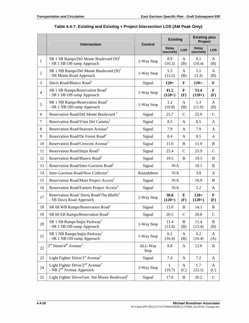
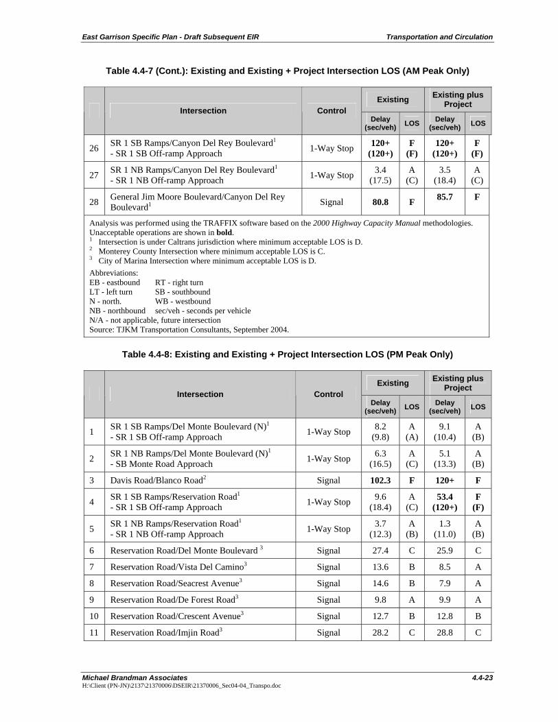
Table 4.4-7: Existing and Existing + Project Intersection LOS (AM Peak Only)
Existing Existing plus Project
Intersection Control Delay
(sec/veh) LOS Delay (sec/veh) LOS
1 SR 1 SB Ramps/Del Monte Boulevard (N)1
- SR 1 SB Off-ramp Approach 1-Way Stop 8.9 (10.3)
A (B)
9.1 (10.4)
A (B)
2 SR 1 NB Ramps/Del Monte Boulevard (N)1
- SB Monte Road Approach 1-Way Stop 5.3 (13.2)
A (B)
5.1 (3.3)
A (B)
3 Davis Road/Blanco Road2 Signal 120+ F 120+. F
4 SR 1 SB Ramps/Reservation Road1
- SR 1 SB Off-ramp Approach 1-Way Stop 41.2 (120+)
F (F)
53.4 (120+)
F (F)
5 SR 1 NB Ramps/Reservation Road1
- SR 1 NB Off-ramp Approach 1-Way Stop 1.2 (10.8)
A (B)
1.3 (11.0)
A (B)
6 Reservation Road/Del Monte Boulevard 3 Signal 25.7 C 25.9 C
7 Reservation Road/Vista Del Camino3 Signal 8.5 A 8.5 A
8 Reservation Road/Seacrest Avenue3 Signal 7.9 A 7.9 A
9 Reservation Road/De Forest Road3 Signal 8.4 A 8.5 A
10 Reservation Road/Crescent Avenue3 Signal 11.0 B 11.0 B
11 Reservation Road/Imjin Road3 Signal 25.4 C 25.9 C
12 Reservation Road/Blanco Road2 Signal 19.5 B 19.5 B
13 Reservation Road/Inter-Garrison Road2 Signal N/A 18.1 B
14 Inter-Garrison Road/New Collector2 Roundabout N/A 3.8 A
15 Reservation Road/Main Project Access2 Signal N/A 18.9 B
16 Reservation Road/Eastern Project Access2 Signal N/A 5.2 A
17 Reservation Road/ Davis Road/The Bluffs2
- SB Davis Road Approach 2-Way Stop 38.8 (120+)
E (F)
120+ (120+)
F (F)
18 SR 68 WB Ramps/Reservation Road1 Signal 13.8 B 14.1 B
19 SR 68 EB Ramps/Reservation Road1 Signal 20.5 C 20.8 C
20 SR 1 SB Ramps/Imjin Parkway1
- SR 1 SB Off-ramp Approach 1-Way Stop 11.4 (13.4)
B (B)
11.4 (13.4)
B (B)
21 SR 1 NB Ramps/Imjin Parkway1
- SR 1 NB Off-ramp Approach 1-Way Stop 0.2 (10.4)
A (B)
0.2 (10.4)
A (A)
22 3rd Street/4th Avenue3 ALL-Way Stop
8.8 A 12.0 B
23 Light Fighter Drive/1st Avenue3 Signal 7.4 A 7.2 A
24 Light Fighter Drive/2nd Avenue3
- NB 2nd Avenue Approach 2-Way Stop 1. (19.7)
A (C)
1.7 (23.1)
A (C)
25 Light Fighter Drive/Gen. Jim Moore Boulevard3 Signal 17.6 B 20.2 C

East Garrison Specific Plan - Draft Subsequent EIR Transportation and Circulation
Michael Brandman Associates 4.4-23 H:\Client (PN-JN)\2137\21370006\DSEIR\21370006_Sec04-04_Transpo.doc
Table 4.4-7 (Cont.): Existing and Existing + Project Intersection LOS (AM Peak Only)
Existing Existing plus Project
Intersection Control Delay
(sec/veh) LOS Delay (sec/veh) LOS
26 SR 1 SB Ramps/Canyon Del Rey Boulevard1
- SR 1 SB Off-ramp Approach 1-Way Stop 120+ (120+)
F (F)
120+ (120+)
F (F)
27 SR 1 NB Ramps/Canyon Del Rey Boulevard1
- SR 1 NB Off-ramp Approach 1-Way Stop 3.4 (17.5)
A (C)
3.5 (18.4)
A (C)
28 General Jim Moore Boulevard/Canyon Del Rey Boulevard1 Signal 80.8 F 85.7 F
Analysis was performed using the TRAFFIX software based on the 2000 Highway Capacity Manual methodologies. Unacceptable operations are shown in bold. 1 Intersection is under Caltrans jurisdiction where minimum acceptable LOS is D. 2 Monterey County Intersection where minimum acceptable LOS is C. 3 City of Marina Intersection where minimum acceptable LOS is D. Abbreviations: EB - eastbound RT - right turn LT - left turn SB - southbound N - north. WB - westbound NB - northbound sec/veh - seconds per vehicle N/A - not applicable, future intersection Source: TJKM Transportation Consultants, September 2004.
Table 4.4-8: Existing and Existing + Project Intersection LOS (PM Peak Only)
Existing Existing plus Project
Intersection Control Delay
(sec/veh) LOS Delay (sec/veh) LOS
1 SR 1 SB Ramps/Del Monte Boulevard (N)1
- SR 1 SB Off-ramp Approach 1-Way Stop 8.2 (9.8)
A (A)
9.1 (10.4)
A (B)
2 SR 1 NB Ramps/Del Monte Boulevard (N)1
- SB Monte Road Approach 1-Way Stop 6.3 (16.5)
A (C)
5.1 (13.3)
A (B)
3 Davis Road/Blanco Road2 Signal 102.3 F 120+ F
4 SR 1 SB Ramps/Reservation Road1
- SR 1 SB Off-ramp Approach 1-Way Stop 9.6 (18.4)
A (C)
53.4 (120+)
F (F)
5 SR 1 NB Ramps/Reservation Road1
- SR 1 NB Off-ramp Approach 1-Way Stop 3.7 (12.3)
A (B)
1.3 (11.0)
A (B)
6 Reservation Road/Del Monte Boulevard 3 Signal 27.4 C 25.9 C
7 Reservation Road/Vista Del Camino3 Signal 13.6 B 8.5 A
8 Reservation Road/Seacrest Avenue3 Signal 14.6 B 7.9 A
9 Reservation Road/De Forest Road3 Signal 9.8 A 9.9 A
10 Reservation Road/Crescent Avenue3 Signal 12.7 B 12.8 B
11 Reservation Road/Imjin Road3 Signal 28.2 C 28.8 C
Transportation and Circulation East Garrison Specific Plan - Draft Subsequent EIR
4.4-24 Michael Brandman Associates H:\Client (PN-JN)\2137\21370006\DSEIR\21370006_Sec04-04_Transpo.doc
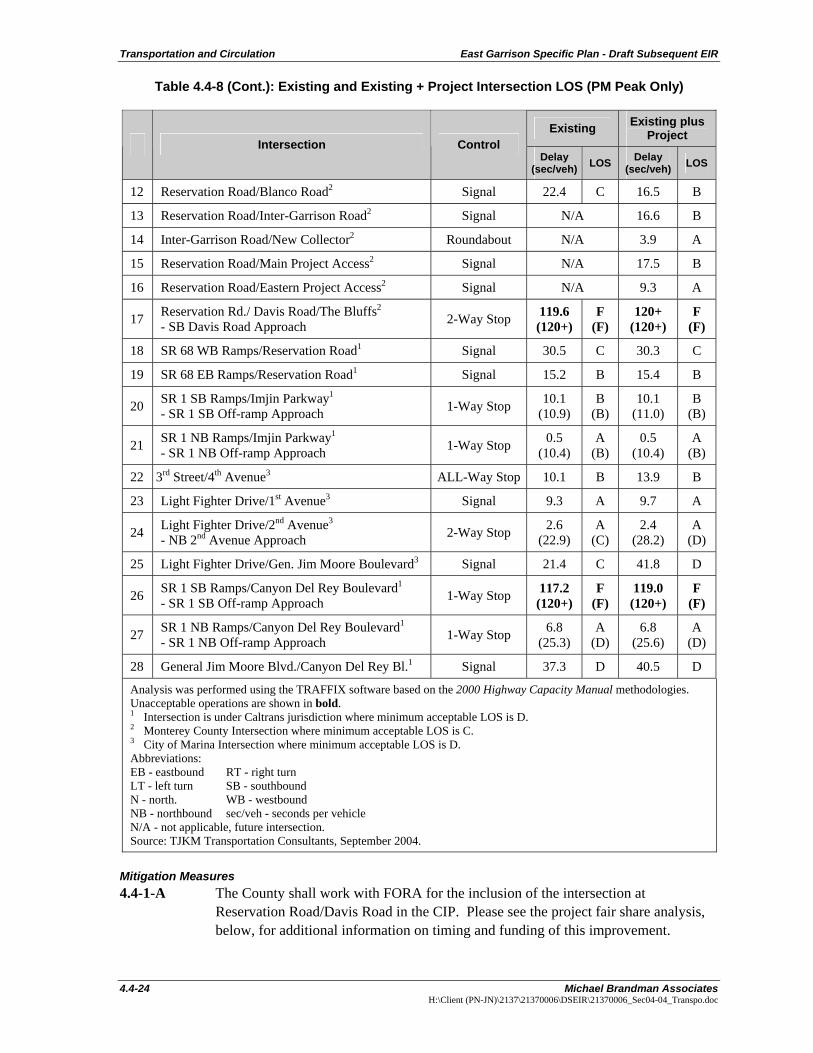
Table 4.4-8 (Cont.): Existing and Existing + Project Intersection LOS (PM Peak Only)
Existing Existing plus Project
Intersection Control Delay
(sec/veh) LOS Delay (sec/veh) LOS
12 Reservation Road/Blanco Road2 Signal 22.4 C 16.5 B
13 Reservation Road/Inter-Garrison Road2 Signal N/A 16.6 B
14 Inter-Garrison Road/New Collector2 Roundabout N/A 3.9 A
15 Reservation Road/Main Project Access2 Signal N/A 17.5 B
16 Reservation Road/Eastern Project Access2 Signal N/A 9.3 A
17 Reservation Rd./ Davis Road/The Bluffs2
- SB Davis Road Approach 2-Way Stop 119.6 (120+)
F (F)
120+ (120+)
F (F)
18 SR 68 WB Ramps/Reservation Road1 Signal 30.5 C 30.3 C
19 SR 68 EB Ramps/Reservation Road1 Signal 15.2 B 15.4 B
20 SR 1 SB Ramps/Imjin Parkway1
- SR 1 SB Off-ramp Approach 1-Way Stop 10.1 (10.9)
B (B)
10.1 (11.0)
B (B)
21 SR 1 NB Ramps/Imjin Parkway1
- SR 1 NB Off-ramp Approach 1-Way Stop 0.5 (10.4)
A (B)
0.5 (10.4)
A (B)
22 3rd Street/4th Avenue3 ALL-Way Stop 10.1 B 13.9 B
23 Light Fighter Drive/1st Avenue3 Signal 9.3 A 9.7 A
24 Light Fighter Drive/2nd Avenue3
- NB 2nd Avenue Approach 2-Way Stop 2.6 (22.9)
A (C)
2.4 (28.2)
A (D)
25 Light Fighter Drive/Gen. Jim Moore Boulevard3 Signal 21.4 C 41.8 D
26 SR 1 SB Ramps/Canyon Del Rey Boulevard1
- SR 1 SB Off-ramp Approach 1-Way Stop 117.2 (120+)
F (F)
119.0 (120+)
F (F)
27 SR 1 NB Ramps/Canyon Del Rey Boulevard1
- SR 1 NB Off-ramp Approach 1-Way Stop 6.8 (25.3)
A (D)
6.8 (25.6)
A (D)
28 General Jim Moore Blvd./Canyon Del Rey Bl.1 Signal 37.3 D 40.5 D
Analysis was performed using the TRAFFIX software based on the 2000 Highway Capacity Manual methodologies. Unacceptable operations are shown in bold. 1 Intersection is under Caltrans jurisdiction where minimum acceptable LOS is D. 2 Monterey County Intersection where minimum acceptable LOS is C. 3 City of Marina Intersection where minimum acceptable LOS is D. Abbreviations: EB - eastbound RT - right turn LT - left turn SB - southbound N - north. WB - westbound NB - northbound sec/veh - seconds per vehicle N/A - not applicable, future intersection. Source: TJKM Transportation Consultants, September 2004.
Mitigation Measures 4.4-1-A The County shall work with FORA for the inclusion of the intersection at
Reservation Road/Davis Road in the CIP. Please see the project fair share analysis, below, for additional information on timing and funding of this improvement.
East Garrison Specific Plan - Draft Subsequent EIR Transportation and Circulation
Michael Brandman Associates 4.4-25 H:\Client (PN-JN)\2137\21370006\DSEIR\21370006_Sec04-04_Transpo.doc
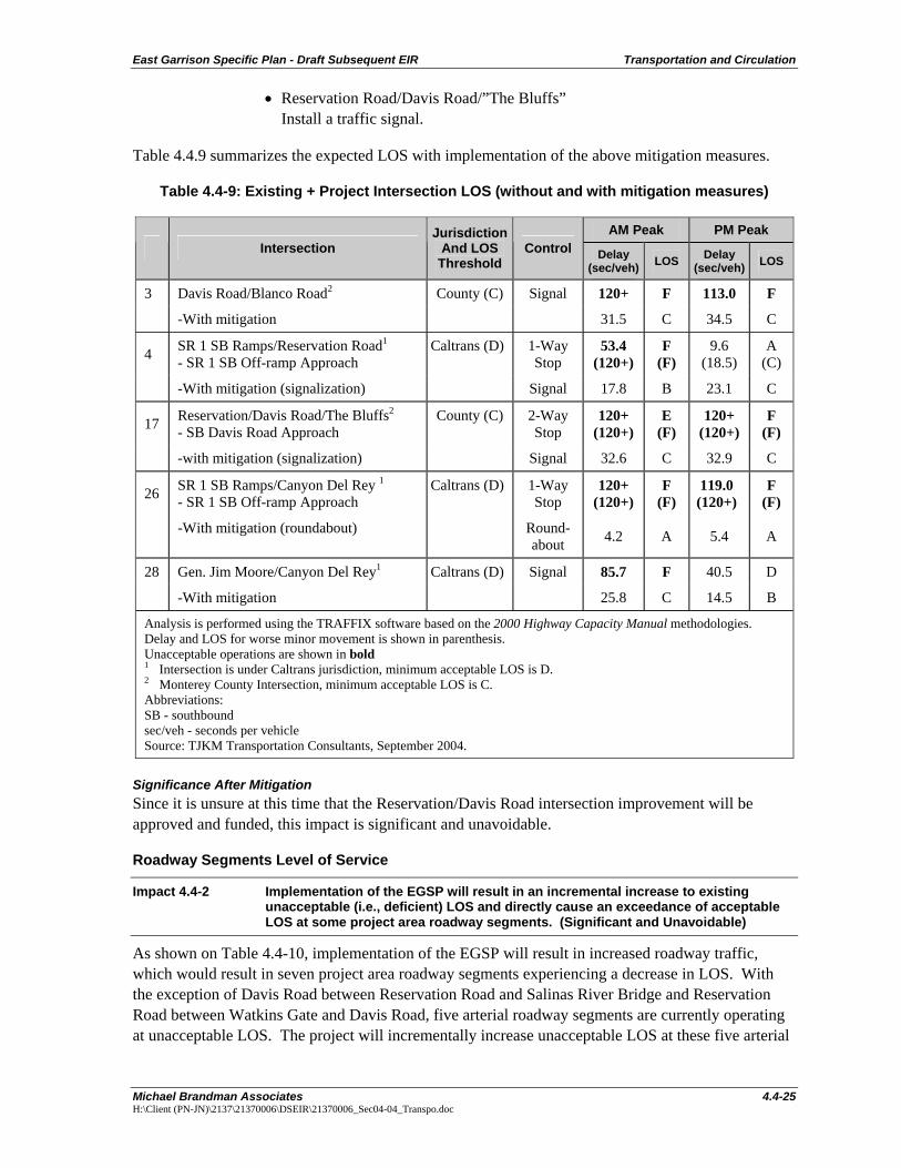
• Reservation Road/Davis Road/”The Bluffs” Install a traffic signal.
Table 4.4.9 summarizes the expected LOS with implementation of the above mitigation measures.
Table 4.4-9: Existing + Project Intersection LOS (without and with mitigation measures)
AM Peak PM Peak Intersection
Jurisdiction And LOS
Threshold Control Delay
(sec/veh) LOS Delay (sec/veh) LOS
3 Davis Road/Blanco Road2 County (C) Signal 120+ F 113.0 F
-With mitigation 31.5 C 34.5 C
4 SR 1 SB Ramps/Reservation Road1
- SR 1 SB Off-ramp Approach Caltrans (D) 1-Way
Stop 53.4
(120+) F
(F) 9.6
(18.5) A
(C)
-With mitigation (signalization) Signal 17.8 B 23.1 C
17 Reservation/Davis Road/The Bluffs2
- SB Davis Road Approach County (C) 2-Way
Stop 120+
(120+) E
(F) 120+
(120+) F
(F)
-with mitigation (signalization) Signal 32.6 C 32.9 C
26 SR 1 SB Ramps/Canyon Del Rey 1
- SR 1 SB Off-ramp Approach Caltrans (D) 1-Way
Stop 120+
(120+) F
(F) 119.0 (120+)
F (F)
-With mitigation (roundabout) Round-about 4.2 A 5.4 A
28 Gen. Jim Moore/Canyon Del Rey1 Caltrans (D) Signal 85.7 F 40.5 D
-With mitigation 25.8 C 14.5 B
Analysis is performed using the TRAFFIX software based on the 2000 Highway Capacity Manual methodologies. Delay and LOS for worse minor movement is shown in parenthesis. Unacceptable operations are shown in bold 1 Intersection is under Caltrans jurisdiction, minimum acceptable LOS is D. 2 Monterey County Intersection, minimum acceptable LOS is C. Abbreviations: SB - southbound sec/veh - seconds per vehicle Source: TJKM Transportation Consultants, September 2004.
Significance After Mitigation Since it is unsure at this time that the Reservation/Davis Road intersection improvement will be approved and funded, this impact is significant and unavoidable.
Roadway Segments Level of Service
Impact 4.4-2 Implementation of the EGSP will result in an incremental increase to existing unacceptable (i.e., deficient) LOS and directly cause an exceedance of acceptable LOS at some project area roadway segments. (Significant and Unavoidable)
As shown on Table 4.4-10, implementation of the EGSP will result in increased roadway traffic, which would result in seven project area roadway segments experiencing a decrease in LOS. With the exception of Davis Road between Reservation Road and Salinas River Bridge and Reservation Road between Watkins Gate and Davis Road, five arterial roadway segments are currently operating at unacceptable LOS. The project will incrementally increase unacceptable LOS at these five arterial
Transportation and Circulation East Garrison Specific Plan - Draft Subsequent EIR
4.4-26 Michael Brandman Associates H:\Client (PN-JN)\2137\21370006\DSEIR\21370006_Sec04-04_Transpo.doc
roadways segments, in addition to causing an unacceptable LOS on two additional roadways segments.
Improvements previously approved and funded for the following roadway segments are included in the FORA CIP. Although the project would result in impacts to the other roadway segments, the County has already planned and funded improvements to improve unacceptable LOS on those five roadway segments as shown in Table 4.4-9.. Funding for these improvements as required under the FORA CIP will be collected from the project applicant; therefore, payment of these fees for the five segments is considered sufficient mitigation.
These arterial roadway segments are identified below. Construction of an addition roadway lane will mitigate impacts to these roadways.
• Blanco Road between Reservation Road and Salinas Bridge: LOS E during the AM and PM peak hours.
• Blanco Road between Salinas River Bridge and Davis Road: LOS E during the AM and PM peak hours.
• Davis Road between Ambrose and Central Avenue: LOS E during the AM and PM peak hours.
• Reservation Road between Portola Drive and SR 68: LOS D during the PM peak hours.
• SR 183 between Cooper Road and Espinosa Road: LOS E during the AM and PM peak hours.
• Davis Road between Reservation Road and Salinas Bridge: LOS D during the PM peak hours.
• Reservation Road between Watkins Gate and Davis Road: LOS D during the PM peak hours.
Table 4.4-10: Segment LOS Analysis - Existing + Project (1,470 Homes) Conditions
Roadway Segment Roadway Direction Lanes AM
LOS PM
LOS
1. Abbott Road between Salinas City Limits and Harris Road N-S 4 A-A A-A
2 Blanco Road between Reservation Road and Salinas River Bridge E-W 2 E E
3 Blanco Road between Salinas River Bridge and Davis Road E-W 2 E E
4 Blanco Road between Davis Road and West Alisal Street E-W 31 B-A B-A
5 SR 1 between Canyon Del Rey and Del Monte Boulevard N-S 4 C-D D-C
6 SR 68 between Portola Interchange and River Road Interchange
E-W 4 A-A A-A
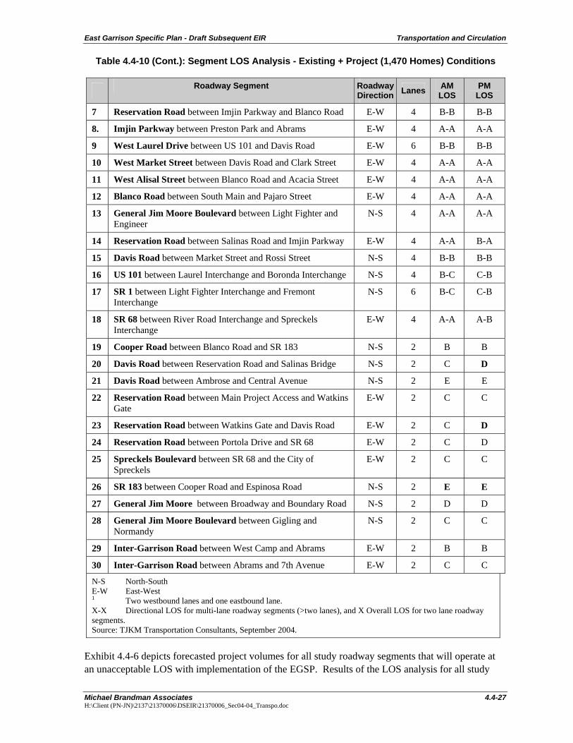
East Garrison Specific Plan - Draft Subsequent EIR Transportation and Circulation
Michael Brandman Associates 4.4-27 H:\Client (PN-JN)\2137\21370006\DSEIR\21370006_Sec04-04_Transpo.doc
Table 4.4-10 (Cont.): Segment LOS Analysis - Existing + Project (1,470 Homes) Conditions
Roadway Segment Roadway Direction Lanes AM
LOS PM
LOS
7 Reservation Road between Imjin Parkway and Blanco Road E-W 4 B-B B-B
8. Imjin Parkway between Preston Park and Abrams E-W 4 A-A A-A
9 West Laurel Drive between US 101 and Davis Road E-W 6 B-B B-B
10 West Market Street between Davis Road and Clark Street E-W 4 A-A A-A
11 West Alisal Street between Blanco Road and Acacia Street E-W 4 A-A A-A
12 Blanco Road between South Main and Pajaro Street E-W 4 A-A A-A
13 General Jim Moore Boulevard between Light Fighter and Engineer
N-S 4 A-A A-A
14 Reservation Road between Salinas Road and Imjin Parkway E-W 4 A-A B-A
15 Davis Road between Market Street and Rossi Street N-S 4 B-B B-B
16 US 101 between Laurel Interchange and Boronda Interchange N-S 4 B-C C-B
17 SR 1 between Light Fighter Interchange and Fremont Interchange
N-S 6 B-C C-B
18 SR 68 between River Road Interchange and Spreckels Interchange
E-W 4 A-A A-B
19 Cooper Road between Blanco Road and SR 183 N-S 2 B B
20 Davis Road between Reservation Road and Salinas Bridge N-S 2 C D
21 Davis Road between Ambrose and Central Avenue N-S 2 E E
22 Reservation Road between Main Project Access and Watkins Gate
E-W 2 C C
23 Reservation Road between Watkins Gate and Davis Road E-W 2 C D
24 Reservation Road between Portola Drive and SR 68 E-W 2 C D
25 Spreckels Boulevard between SR 68 and the City of Spreckels
E-W 2 C C
26 SR 183 between Cooper Road and Espinosa Road N-S 2 E E
27 General Jim Moore between Broadway and Boundary Road N-S 2 D D
28 General Jim Moore Boulevard between Gigling and Normandy
N-S 2 C C
29 Inter-Garrison Road between West Camp and Abrams E-W 2 B B
30 Inter-Garrison Road between Abrams and 7th Avenue E-W 2 C C
N-S North-South E-W East-West 1 Two westbound lanes and one eastbound lane. X-X Directional LOS for multi-lane roadway segments (>two lanes), and X Overall LOS for two lane roadway segments. Source: TJKM Transportation Consultants, September 2004.
Exhibit 4.4-6 depicts forecasted project volumes for all study roadway segments that will operate at an unacceptable LOS with implementation of the EGSP. Results of the LOS analysis for all study
Transportation and Circulation East Garrison Specific Plan - Draft Subsequent EIR
4.4-28 Michael Brandman Associates H:\Client (PN-JN)\2137\21370006\DSEIR\21370006_Sec04-04_Transpo.doc
area arterial roadway segments, under the EGSP, are shown in Table 4.4-11. Detailed LOS calculation sheets are contained as part of the Traffic Impact Study in Appendix E of this DSEIR.
Mitigation Measures 4.4-2-A The County shall work with FORA for the inclusion of widening of the following
roadway segments in the CIP. Please see the project fair share analysis, below, for additional information on timing and funding of this improvement.
• Reservation Road between Portola Drive and SR 68. • SR 183 between Cooper Road and Espinosa Road.
Significance After Mitigation Since it is unsure at this time that these roadway segment improvements will be approved and funded, this impact is significant and unavoidable.
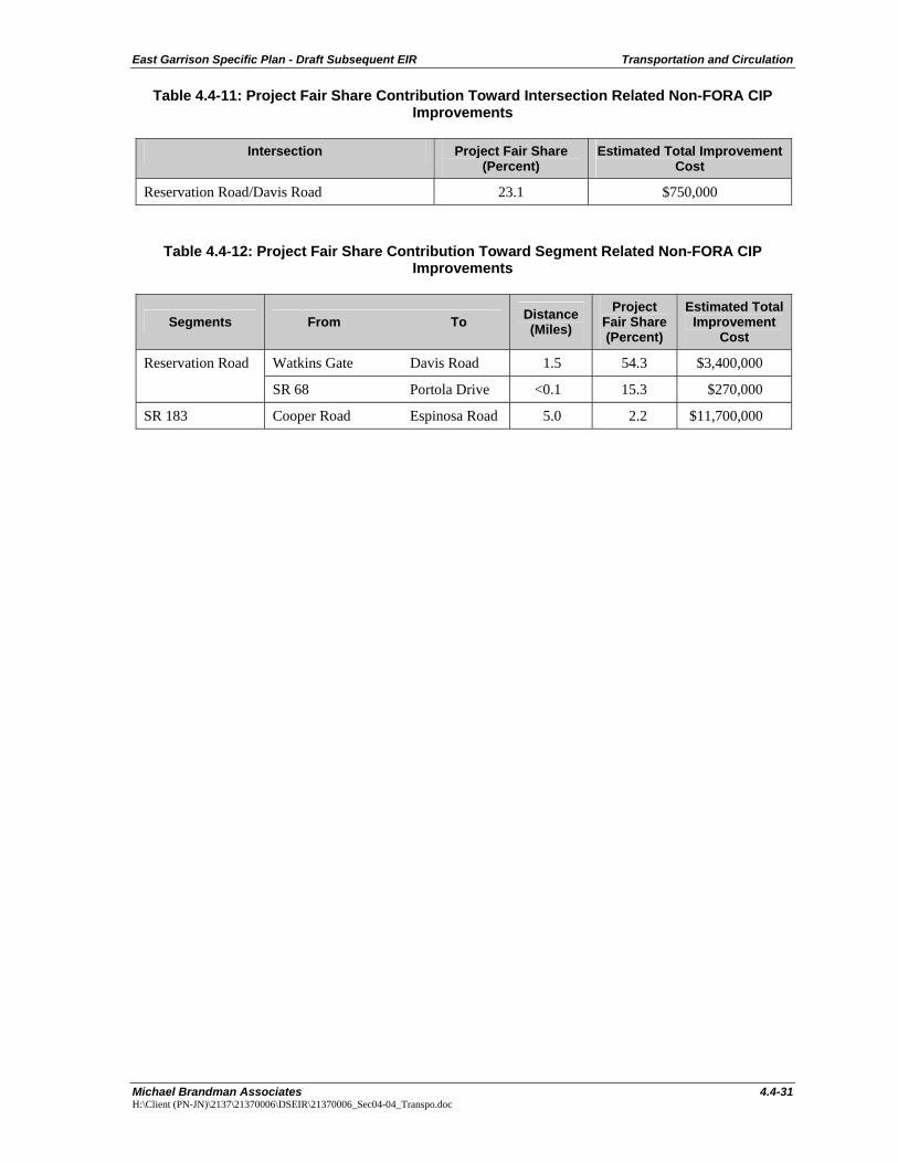
PROJECT FAIR SHARE ANALYSIS
The project sponsor (in consultation with the Monterey County Public Works Department [MCPWD]) shall contribute its fair share (in the form of Fort Ord Reuse Authority (FORA) fees for 1,470 homes). These fees will go towards mitigating expected impacts at study intersections and roadway segments that are included in the FORA Capital Improvement Program (CIP). Based on the information provided at the official FORA CIP website (Table 2—Transportation Network and Transit Elements), the following summarizes the estimated schedule for transportation obligations over the CIP horizon (FY 2003/2004 through FY 2021/2022):
• Improvements related to Davis Road and Blanco Road are scheduled for completion in 2017 • Improvements related to General Jim Moore Boulevard are scheduled for completion in 2006 • Improvements related to Reservation Road are scheduled for completion in 2007
Therefore, it is reasonable to assume that improvements at General Jim Moore Boulevard and at Reservation Road will be completed by 2012, when the project is scheduled to be fully occupied. However, the level-of-service results for the Existing plus Project Conditions do not assume that these improvements are in place.
Tables 4.4-11 and 4.4-12 list the impacted intersections and roadway segments that are not covered under the FORA CIP, the estimated improvement costs and the project fair share contributions. Based on the MCPWD guidelines, the project fair share analysis was completed using the methodology for calculating equitable mitigation measures. The project’s fair share may be conservatively high since there probably will be other future development (between now and 2012) that will generate trips at Reservation Road/Davis Road and the three roadway segments (listed on Table 4.4-11) that will also contribute their pro-rata share for improvements, thus lowering the project’s fair share.
The project sponsor (in consultation with the MCPWD) is expected to make payments over the course of the construction of different phases of the project except for the improvements at Reservation Road/Davis Road. For this intersection, the project sponsor is expected to pay the entire improvement cost (roughly estimated to be $750,000) as part of Phase I construction. As part of a reimbursement agreement program with the project sponsor, the MCPWD is expected to reimburse the improvement costs (that are not attributable to the project) after future development make their fair share payments.

East Garrison Specific Plan - Draft Subsequent EIR Transportation and Circulation
Michael Brandman Associates 4.4-31 H:\Client (PN-JN)\2137\21370006\DSEIR\21370006_Sec04-04_Transpo.doc
Table 4.4-11: Project Fair Share Contribution Toward Intersection Related Non-FORA CIP Improvements
Intersection Project Fair Share (Percent)
Estimated Total Improvement Cost
Reservation Road/Davis Road 23.1 $750,000
Table 4.4-12: Project Fair Share Contribution Toward Segment Related Non-FORA CIP Improvements
Segments From To Distance (Miles)
Project Fair Share (Percent)
Estimated Total Improvement
Cost
Watkins Gate Davis Road 1.5 54.3 $3,400,000 Reservation Road
SR 68 Portola Drive <0.1 15.3 $270,000
SR 183 Cooper Road Espinosa Road 5.0 2.2 $11,700,000