Embed Size (px)
Citation preview
WEATHER AND CLIMATEANSWERS
4-Temperature
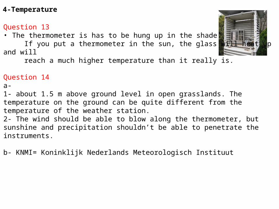
Question 13 • The thermometer is has to be hung up in the shade. If you put a thermometer in the sun, the glass will heat up and will reach a much higher temperature than it really is.
Question 14 a-1- about 1.5 m above ground level in open grasslands. The temperature on the ground can be quite different from the temperature of the weather station.2- The wind should be able to blow along the thermometer, but sunshine and precipitation shouldn’t be able to penetrate the instruments.
b- KNMI= Koninklijk Nederlands Meteorologisch Instituut
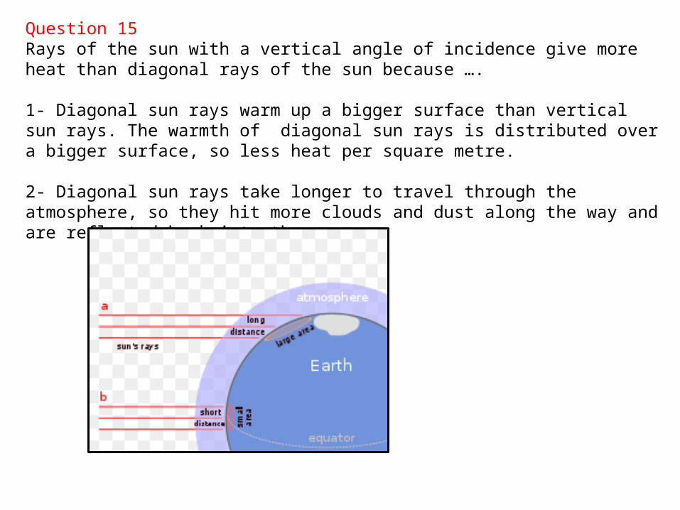
Question 15Rays of the sun with a vertical angle of incidence give more heat than diagonal rays of the sun because ….
1- Diagonal sun rays warm up a bigger surface than vertical sun rays. The warmth of diagonal sun rays is distributed over a bigger surface, so less heat per square metre.
2- Diagonal sun rays take longer to travel through the atmosphere, so they hit more clouds and dust along the way and are reflected back into the cosmos.
Question 17
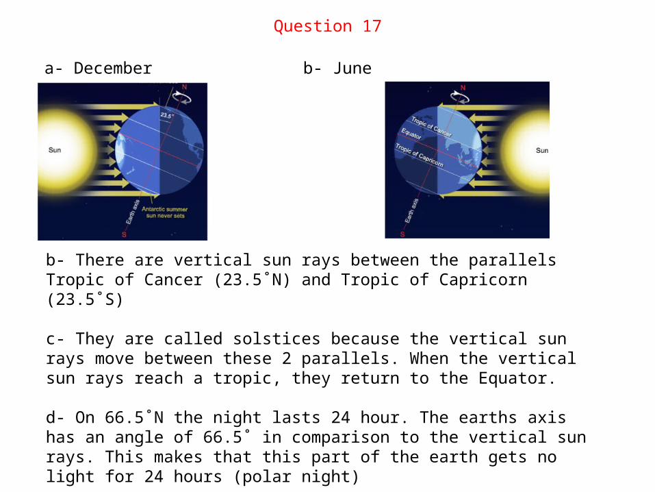
a- December b- June
b- There are vertical sun rays between the parallels Tropic of Cancer (23.5˚N) and Tropic of Capricorn (23.5˚S)
c- They are called solstices because the vertical sun rays move between these 2 parallels. When the vertical sun rays reach a tropic, they return to the Equator.
d- On 66.5˚N the night lasts 24 hour. The earths axis has an angle of 66.5˚ in comparison to the vertical sun rays. This makes that this part of the earth gets no light for 24 hours (polar night)
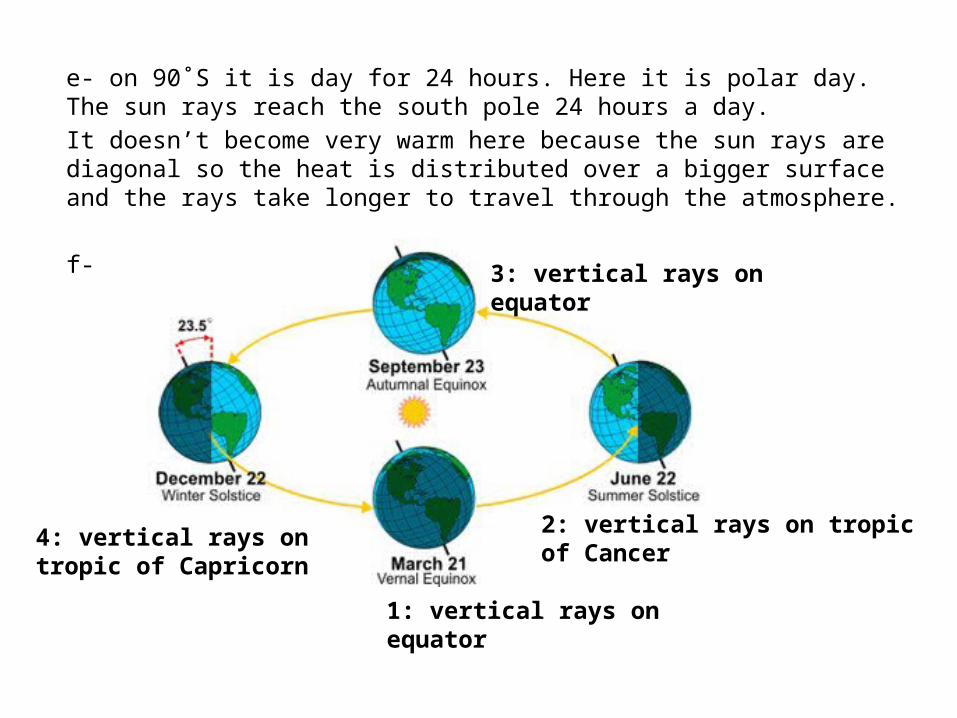
e- on 90˚S it is day for 24 hours. Here it is polar day. The sun rays reach the south pole 24 hours a day.
It doesn’t become very warm here because the sun rays are diagonal so the heat is distributed over a bigger surface and the rays take longer to travel through the atmosphere.
f-
1: vertical rays on equator
2: vertical rays on tropic of Cancer
3: vertical rays on equator
4: vertical rays on tropic of Capricorn
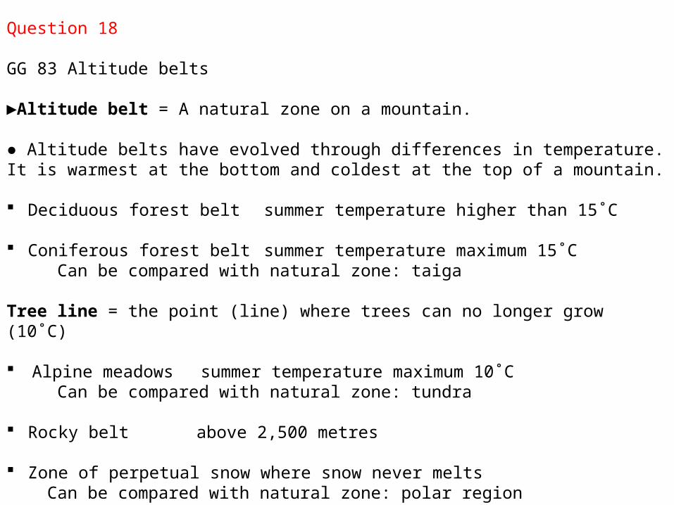
Question 18
GG 83 Altitude belts
►Altitude belt = A natural zone on a mountain.
● Altitude belts have evolved through differences in temperature. It is warmest at the bottom and coldest at the top of a mountain.
Deciduous forest belt summer temperature higher than 15˚C
Coniferous forest belt summer temperature maximum 15˚C Can be compared with natural zone: taiga
Tree line = the point (line) where trees can no longer grow (10˚C)
Alpine meadows summer temperature maximum 10˚C Can be compared with natural zone: tundra
Rocky belt above 2,500 metres
Zone of perpetual snow where snow never melts Can be compared with natural zone: polar region
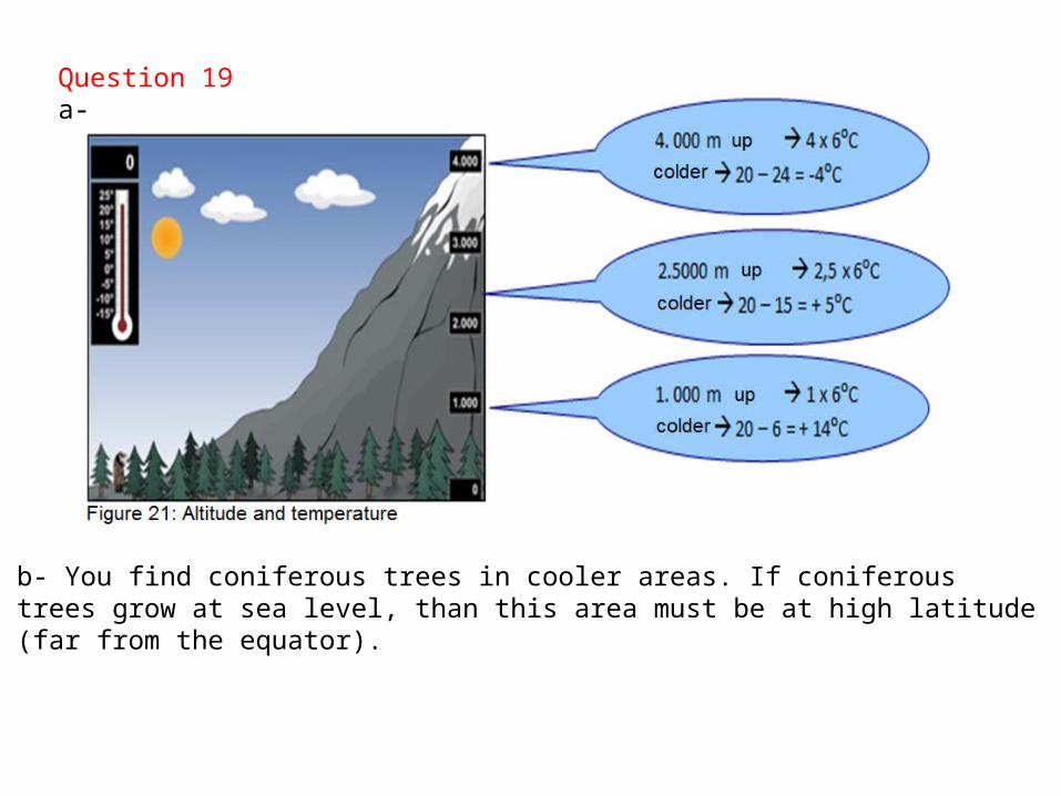
b- You find coniferous trees in cooler areas. If coniferous trees grow at sea level, than this area must be at high latitude (far from the equator).
Question 19a-
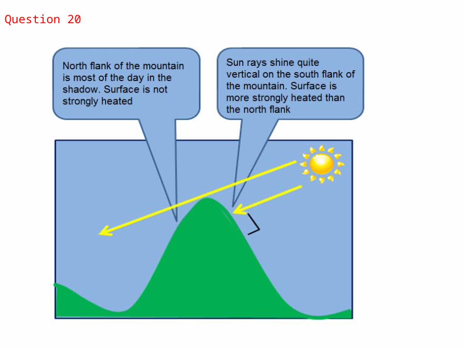
Question 20
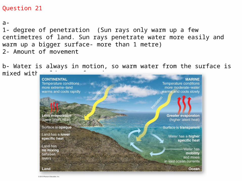
Question 21
a- 1- degree of penetration (Sun rays only warm up a few centimetres of land. Sun rays penetrate water more easily and warm up a bigger surface- more than 1 metre) 2- Amount of movement
b- Water is always in motion, so warm water from the surface is mixed with cold water from deeper parts.
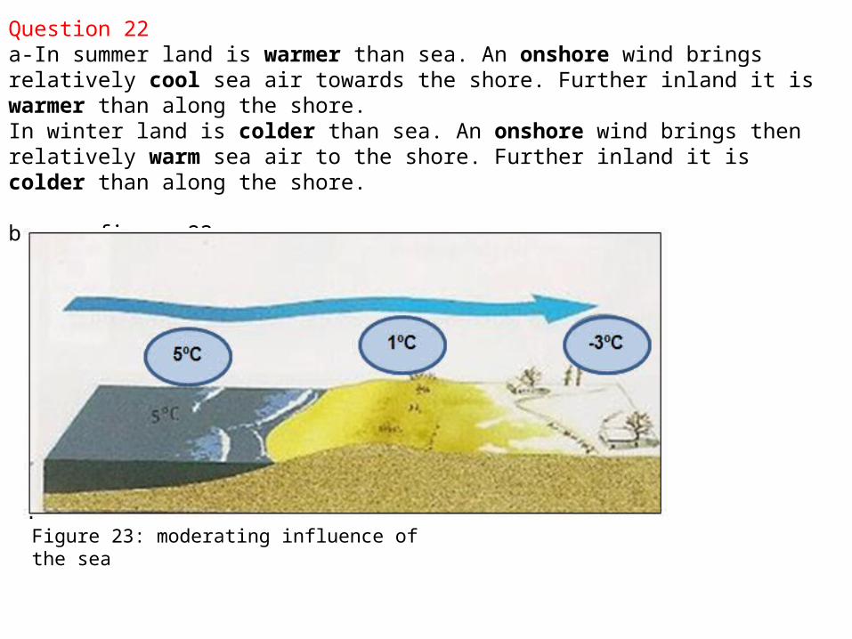
Question 22a-In summer land is warmer than sea. An onshore wind brings relatively cool sea air towards the shore. Further inland it is warmer than along the shore. In winter land is colder than sea. An onshore wind brings then relatively warm sea air to the shore. Further inland it is colder than along the shore.
b- see figure 23
Figure 23: moderating influence of the sea
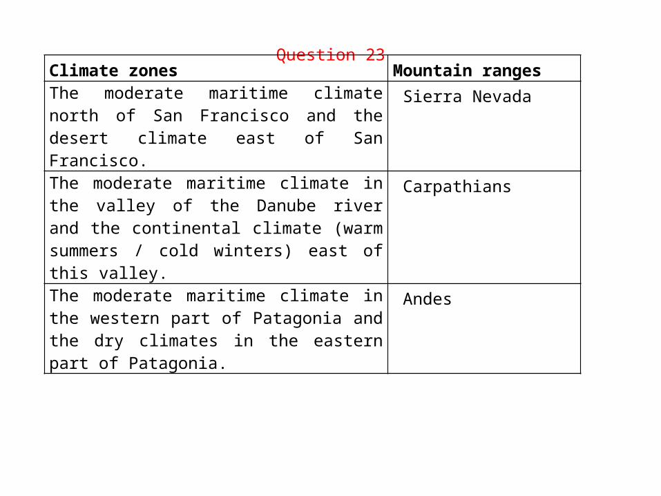
Question 23Climate zones Mountain rangesThe moderate maritime climate north of San Francisco and the desert climate east of San Francisco.
Sierra Nevada
The moderate maritime climate in the valley of the Danube river and the continental climate (warm summers / cold winters) east of this valley.
Carpathians
The moderate maritime climate in the western part of Patagonia and the dry climates in the eastern part of Patagonia.
Andes
Question 24
a- Egmond aan Zee has 6-8 ice days and Coevorden more than 12. This difference is caused by the distance to the sea.
The sea is moderating the temperature along the coastline, but of less influence more inland.
- The average year temperature temperature in Breskens is 10.5-10.8˚C and in Delfzijl 9.3-9.6˚C
This difference is caused by difference in latitude.
b- (map 47E and 47F in 53e edition map 40A2 and 40E in 54th edition)The areas with most sun hours are not the same as the areas with the highest temperature. In summer most sunshine is along the coastline, but the sea moderates the temperature. So you don’t see highest temperatures here!
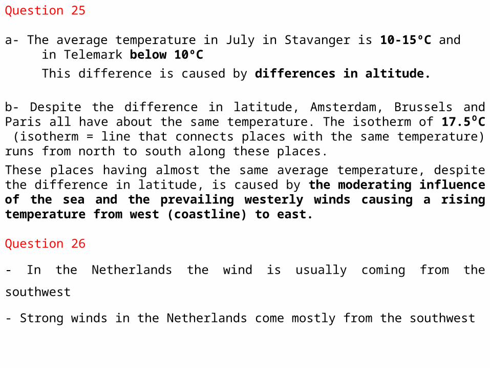
Question 25
a- The average temperature in July in Stavanger is 10-15ºC and in Telemark below 10ºC
This difference is caused by differences in altitude.
b- Despite the difference in latitude, Amsterdam, Brussels and Paris all have about the same temperature. The isotherm of 17.5 C⁰ (isotherm = line that connects places with the same temperature) runs from north to south along these places.
These places having almost the same average temperature, despite the difference in latitude, is caused by the moderating influence of the sea and the prevailing westerly winds causing a rising temperature from west (coastline) to east.
Question 26
- In the Netherlands the wind is usually coming from the southwest
- Strong winds in the Netherlands come mostly from the southwest
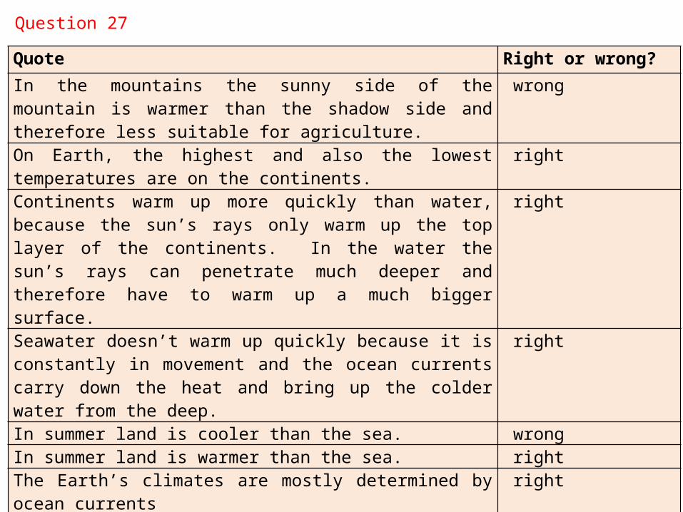
Quote Right or wrong?
In the mountains the sunny side of the mountain is warmer than the shadow side and therefore less suitable for agriculture.
wrong
On Earth, the highest and also the lowest temperatures are on the continents.
right
Continents warm up more quickly than water, because the sun’s rays only warm up the top layer of the continents. In the water the sun’s rays can penetrate much deeper and therefore have to warm up a much bigger surface.
right
Seawater doesn’t warm up quickly because it is constantly in movement and the ocean currents carry down the heat and bring up the colder water from the deep.
right
In summer land is cooler than the sea. wrongIn summer land is warmer than the sea. rightThe Earth’s climates are mostly determined by ocean currents rightOcean currents bring cold water from the north to the south. sometimes, not always
Question 27