Embed Size (px)
Citation preview
3D seismic technology: are we realising its full potential?
R I C H A R D J. D A V I E S 1, S I M O N A. S T E W A R T 2, J O S E P H A . C A R T W R I G H T 1, M A R K
L A P P I N 3, R O D N E Y J O H N S T O N 4, S C O T I. F R A S E R 5 & A L I S T A I R R. B R O W N 6
13DLab, School of Earth, Ocean and Planetary Sciences, Cardiff University, Main Building Park Place,
Cardiff CFIO 3YE, UK (e-mail: [email protected]) 2BP Azerbaijan, C/o Chertsey Road, Sunbuo, on Thames, Middlesex TWI6 7LN, UK
3ExxonMobil Exploration Company, 233 Benmar, Houston, Texas 77060, USA 4Bp, E & P Technology Group, Chertsey Road, Sunbuo' on Thames, Middlesex TW16 7LN, UK
5Shell EP Technology Solutions, Shell International Exploration & Production Inc., 200 N Dairy Ashford,
Houston, Texas 77079, USA 6Consulting Reservoir Geophysicist, 1911 Country Brook Lane, Allen, Texas 75002, USA
Abstract: Three-dimensional (3D) seismic data have had a substantial impact on the successful exploration and production of hydrocarbons. Although most commonly acquired by the oil and gas exploration industry, these data are starting to be used as a research tool in other Earth sciences disciplines. However despite some innovative new directions of academic investigation, most of the examples of how 3D seismic data have increased our understanding of the structure and stratigraphy of sedimentary basins come from the industry that acquired these data. The 3D seismic tool is also making significant inroads into other areas of Earth sciences, such as igneous and structural geology. However, there are pitfalls that parallel these advances: geoscientists need to be multidisciplined and true integrators, and at the same time have an ever-increasing knowledge of geophysical acquisition and processing. Notably the utility of the 3D seismic tool seems to have been overlooked by most of the academic community, and we would submit that academia has yet to take full advantage of this technology as a research tool. We propose that the remaining scientific potential far exceeds the advances made thus far and major opportunities, as well as challenges, lie ahead.
The age of field-based geological mapping that began with William Smith (1769-1839) started as a result of technological advances such as mining and canal building, which in turn were fuelled by basic commercial needs (Winchester 2001). In a similar way, a 'new age' of subsurface geological mapping that is just as far-ranging in scope as the early surface geological mapping campaigns is emerging. It is the direct result of the advent of 2D and subsequently 3D seismic data along with advances in seismic acquisition and processing over the past three decades. This 21st century 'quiet' revolution is driven by the increasingly sophisticated technological demands made by today's oil and gas exploitation industry but surprisingly this is going on almost without remark from less directly related sectors of the academic geological community.
The 3D seismic technology revolution has its roots in the 1930s when the first 2D data were acquired. A key evolutionary stage was the advent of digital recording and processing techniques during the 1960s. This facilitated 2D subsurface imaging, followed in the 1970s by 3D imaging. The first commercial 3D survey was recorded in 1975 in the North Sea and was interpreted in the same year. 3D seismic data quickly evolved from a research idea to cost-effective methods that have substantially boosted the efficiency of finding and recovering hydrocarbons. The quality of modern 3D seismic data is so high in many cases, that the data are starting to be used as a research tool and this is just beginning to allow researchers to challenge certain paradigms of stratigraphy and structural geology.
The use of seismic data in the oil and gas industry quickly led to a number of scientific advances. For example a reinvigoration in stratigraphy started in the 1950s as a direct result of the development of the common mid-point method (Liner et al. 1999) and the acquisition and interpretation of 2D seismic data (Payton 1977). Widespread dissemination of the rapidly expanding 3D database has the potential to advance many geological disciplines which, in contrast to the 'stratigraphy revolution', perhaps have less direct impact on the oil and
gas industry. In particular, the availability of surveys covering several thousand square kilometres now enables basin-scale processes to be investigated using the potential high spatial resolution of 3D seismic data. New sedimentary and structural phenomena are being imaged and explained for the first time. These advances are perhaps not surprising when one considers the scale limitations of most outcrop, which historically is the most utilized type of geological data for studying structures at similar scales. Many of our fundamental geological concepts are rooted at the outcrop scale and therefore the alternative perspective provided by 3D seismic imaging holds considerable promise for developing and challenging these concepts, as well as revealing new phenomena. Examples in this volume show new phenomena that are recognized with 3D seismic, simply because their size is such that they cannot be seen in toto for what they are at outcrop.
The aim of this introductory paper is to explore the breadth of the impact of 3D seismic technology on the geological sciences and to capture the overall aims of the volume: to raise the profile of 3D seismic interpretation within the Earth science discipline. The paper will set the scene for the Memoir by reviewing the progress that has been made over the past three decades in the development and application of 3D seismic technology and exploring the future opportunities. The funda- mental objective of the paper is to pose the question: are we fully realizing the scientific potential that these data and the technology could offer to Earth sciences?
2 D vs 3D s e i s m i c da ta
The ability to acquire and process 2D seismic data was developed in the 1950s; 3D seismic data followed in the 1980s (Liner et al. 1999). 3D seismic is distinguished from 2D seismic by the acquisition of multiple closely spaced lines (e.g. 25 m) that provides regular data point spacing that feeds 3D data migration during processing. This leads to a true data volume
DAVIES, R. J., CARTWR1GHT, J. A., STEWART, S. A., LAPPIN, M. & UNDERHILL, J. R. (eds) 2004.3D Seismic Technology: Application to the Exploration of Sedimentary Basins. Geological Society, London, Memoirs, 29, 1-9. 0435-40521041515 �9 The Geological Society of London 2004.
by guest on May 19, 2018http://mem.lyellcollection.org/Downloaded from
2 R.J. DAVIES ET AL.
from which lines, planes, slices or 'probes' can be extracted in any orientation, with nominally consistent data processing characteristics. While it is possible to acquire a dense, 'high- resolution' grid of 2D lines, or create a mesh of 2D coverage by assembling spatially coincident 2D surveys of different vintages, such grids are fundamentally different from true 3D seismic data (Lonergan & White 1999). The close line spacing of 3D seismic data means that these data do not have the problems of spatial aliasing inherent to 2D seismic data, and therefore have the potential to yield better stratigraphic resolution, better migration and imaging of structural and depositional dips. The density of subsurface reflection point coverage allows stratal reflections to be mapped using automated or semi-automated trackers to provide continuous mapped surfaces that may in turn be used to derive a range of seismic and structural attributes. These attributes feature increasingly in exploration and development workflows. Fundamentally, however, the greatest benefit of 3D resides in its spatial resolving power both in terms of absolute spatial resolution and relative accuracy in image positioning due to 3D migration techniques employed during the processing of the seismic data (Yilmaz 2001). Features such as fault systems can now be mapped in much more detail than was possible with 2D seismic data, with its inherent limitations of spatial aliasing (Freeman et al. 1990).
Commercial considerations
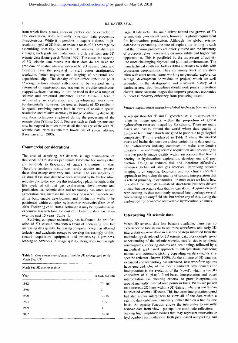
The cost of acquiring 3D datasets is significant--tens of thousands of US dollars per square kilometre for surveys that are hundreds to thousands of square kilometres in size. Therefore academic institutions rarely acquire and process these data except over very small areas. The vast majority of existing 3D seismic data have been acquired by the hydrocarbon industry due to the key role this technology plays throughout the life cycle of oil and gas exploration, development and production. 3D seismic data and technology can often reduce exploration risk, increase the accuracy of reservoir models and at its best, enable development and production wells to be positioned within complex hydrocarbon reservoirs (Dart et aI. 2004; Pickering et al. 2004). Although it may be regarded as an expensive research tool, the cost of 3D seismic data has fallen over the past 15 years (Table 1).
Evolving computer technology has facilitated the prolifer- ation of 3D seismic data with a trend of decreasing cost but increasing data quality. Increasing computer power has allowed industry and academic groups to develop increasingly sophis- ticated acquisition equipment and processing algorithms, leading to advances in image quality along with increasingly
Table 1. Cost versus year of acquisition for 3D seismic data in the North Sea, UK
North Sea 3D cost over time
Year k USD (sq km)
1982 70-100
1986 30
1990 12-15
1993 8-9
1999 4
2002 10-20
large 3D datasets. The main driver behind the growth of 3D seismic data over recent years, however, is global requirement for hydrocarbon production. Although the global seismic database is expanding, the rate of exploration drilling is such that the obvious prospects are quickly tested and the inventory of prospects relies increasingly on more subtle and higher risk opportunities. This is paralleled by the movement of activity into more challenging physical and political environments. The main technical challenge today (2004) continues to reside with processing geophysicists. They commonly work in collabor- ation with asset teams (teams working on particular exploration acreage, development or production project) which are well grounded in the stratigraphic and structural history of a particular area. Both disciplines should work jointly to produce clearer, more accurate images that improve prospect economics or increase recovery efficiency from producing assets.
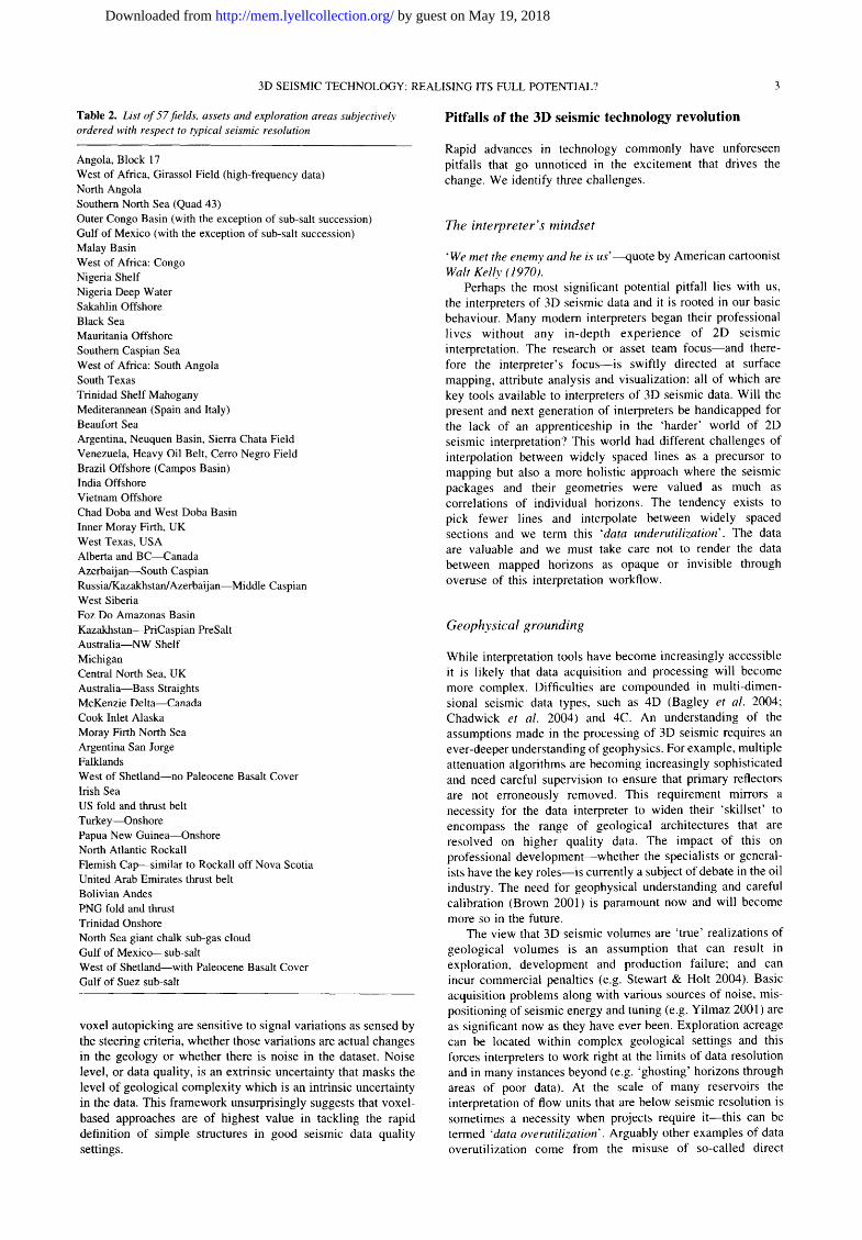
F u t u r e exp lora t ion i m p a c t - - g l o b a l h y d r o c a r b o n reserves
A key question for 'E and P' geoscientists is to consider the range in image quality within the proportion of global hydrocarbon reserves imaged by 3D seismic. There are many assets and basins around the world where data quality is excellent but many datasets are good to poor due to geological complexity. This is evidenced in Table 2 where the marked assets and basins demonstrate a clear variability in data quality. The hydrocarbon industry continues to make considerable investment in improving seismic acquisition and processing to improve poorly image quality within successions that have a bearing on hydrocarbon exploration, development and pro- duction. Doing so reduces risk and therefore effectively increases global oil and gas reserves. Improving seismic imaging is an ongoing, long-term and sometimes uncertain approach to improving the quality of seismic interpretation that is related primarily to economics--in most cases we know how to collect the right data--instead short-term business drivers dictate that we acquire data that we can afford. Acquisition (and reprocessing) is then commonly repeated later, perhaps several times during not only field life, but before any of this, during the exploration for economic recoverable hydrocarbon volumes.
Interpreting 3D seismic data
When 3D seismic data first became available, there was no experience or tool in use to optimize workflows, and early 3D interpretations were done in a series of steps inherited from the methodology developed for 2D seismic data. For example, good understanding of the seismic wavelet, careful ties to synthetic seismograms, checking datums and positioning, followed by a methodical, grid based approach to interpretation, balancing manual and automatic picking depending on data quality at a specific reflector (Brown 1999). As the volume of 3D data has expanded and technology has advanced, new workflow options have emerged. One of the most significant developments for interpretation is the evolution of the 'voxel', which is the 3D equivalent of a 'pixel'. Pixel-based interpretation and voxel interpretation use 'steering criteria' to grow interpretations around manually inserted seed points or lines. Pixels are picked on numerous 2D lines within a 3D dataset, where as voxels can be selected within a 3D cube. This increases interpretation speed but also allows interpreters to view all of the data within a seismic data cube simultaneously, rather than on a line by line basis. An opacity function allows the interpreter to instantly remove data from view--perhaps low-amplitude reflections-- leaving high amplitude bodies that may represent reservoirs or hydrocarbon accumulations. Both pixel-based autopicking and
by guest on May 19, 2018http://mem.lyellcollection.org/Downloaded from
3D SEISMIC TECHNOLOGY: REALISING ITS FULL POTENTIAL? 3
Table 2. List of 57 fields, assets and exploration areas subjectively ordered with respect to typical seismic resolution
Angola, Block 17 West of Africa, Girassol Field (high-frequency data) North Angola Southern North Sea (Quad 43) Outer Congo Basin (with the exception of sub-salt succession) Gulf of Mexico (with the exception of sub-salt succession) Malay Basin West of Africa: Congo Nigeria Shelf Nigeria Deep Water Sakahlin Offshore Black Sea Mauritania Offshore Southern Caspian Sea West of Africa: South Angola South Texas Trinidad Shelf Mahogany Mediterannean (Spain and Italy) Beaufort Sea Argentina, Neuquen Basin, Sierra Chata Field Venezuela, Heavy Oil Belt, Cerro Negro Field Brazil Offshore (Campos Basin) India Offshore Vietnam Offshore Chad Doba and West Doba Basin Inner Moray Firth, UK West Texas, USA Alberta and B C ~ a n a d a Azerbaijan--South Caspian Russia/Kazakhstan/Azerbaij an--Middle Caspian West Siberia Foz Do Amazonas Basin Kazakhstan--PriCaspian PreSalt Australia--NW Shelf Michigan Central North Sea, UK Australia--Bass Straights McKenzie Delta--Canada Cook Inlet Alaska Moray Firth North Sea Argentina San Jorge Falklands West of Shetland--no Paleocene Basalt Cover Irish Sea US fold and thrust belt Turkey--Onshore Papua New Guinea--Onshore North Atlantic Rockall Flemish Cap---similar to Rockall off Nova Scotia United Arab Emirates thrust belt Bolivian Andes PNG fold and thrust Trinidad Onshore North Sea giant chalk sub-gas cloud Gulf of Mexico--sub-salt West of Shetland--with Paleocene Basalt Cover Gulf of Suez sub-salt
voxel autopicking are sensitive to signal variations as sensed by the steering criteria, whether those variations are actual changes in the geology or whether there is noise in the dataset. Noise level, or data quality, is an extrinsic uncertainty that masks the level of geological complexity which is an intrinsic uncertainty in the data. This framework unsurprisingly suggests that voxel- based approaches are of highest value in tackling the rapid definition of simple structures in good seismic data quality settings.
Pitfalls of the 3D seismic technology revolution
Rapid advances in technology commonly have unforeseen pitfalls that go unnoticed in the excitement that drives the change. We identify three challenges.
The in terpreter 's mindse t
"We met the enemy and he is us ' - -quote by American cartoonist Walt Kelly (1970).
Perhaps the most significant potential pitfall lies with us, the interpreters of 3D seismic data and it is rooted in our basic behaviour. Many modern interpreters began their professional lives without any in-depth experience of 2D seismic interpretation. The research or asset team focus--and there- fore the interpreter's focus--is swiftly directed at surface mapping, attribute analysis and visualization: all of which are key tools available to interpreters of 3D seismic data. Will the present and next generation of interpreters be handicapped for the lack of an apprenticeship in the 'harder' world of 2D seismic interpretation? This world had different challenges of interpolation between widely spaced lines as a precursor to mapping but also a more holistic approach where the seismic packages and their geometries were valued as much as correlations of individual horizons. The tendency exists to pick fewer lines and interpolate between widely spaced sections and we term this 'data underutilization'. The data are valuable and we must take care not to render the data between mapped horizons as opaque or invisible through overuse of this interpretation workflow.
Geophys ica l grounding
While interpretation tools have become increasingly accessible it is likely that data acquisition and processing will become more complex. Difficulties are compounded in multi-dimen- sional seismic data types, such as 4D (Bagley et al. 2004; Chadwick et al. 2004) and 4C. An understanding of the assumptions made in the processing of 3D seismic requires an ever-deeper understanding of geophysics. For example, multiple attenuation algorithms are becoming increasingly sophisticated and need careful supervision to ensure that primary reflectors are not erroneously removed. This requirement mirrors a necessity for the data interpreter to widen their 'skillset' to encompass the range of geological architectures that are resolved on higher quality data. The impact of this on professional development--whether the specialists or general- ists have the key roles--is currently a subject of debate in the oil industry. The need for geophysical understanding and careful calibration (Brown 2001) is paramount now and will become more so in the future.
The view that 3D seismic volumes are 'true' realizations of geological volumes is an assumption that can result in exploration, development and production failure; and can incur commercial penalties (e.g. Stewart & Holt 2004). Basic acquisition problems along with various sources of noise, mis- positioning of seismic energy and tuning (e.g. Yilmaz 2001 ) are as significant now as they have ever been. Exploration acreage can be located within complex geological settings and this forces interpreters to work right at the limits of data resolution and in many instances beyond (e.g. 'ghosting' horizons through areas of poor data). At the scale of many reservoirs the interpretation of flow units that are below seismic resolution is sometimes a necessity when projects require i t--this can be termed 'data overutilization'. Arguably other examples of data overutilization come from the misuse of so-called direct
by guest on May 19, 2018http://mem.lyellcollection.org/Downloaded from
4 R.J. DAVIES ETAL.
hydrocarbon indicators (DHIs). Many experienced industry interpreters will be able to recount examples of prospects that were dramatically de-risked through the identification of a DHI that did not make geological sense. In many cases pros- pects have been drilled on 'overutilized' data and have been proven dry.
Other common pitfalls include the tendency in clastic successions to view seismic amplitudes as a direct indicator of lithology. This of course should be cautioned against as fluid content can significantly reduce acoustic impedance and there- fore seismic amplitude. To get indications of fluid or lithology from 3D seismic or impedance volumes typically requires further processing after a thorough petrophysical study of the rock involved (Whitcombe et al. 2002).
The e v o l v i n g ro le o f the s e i s m i c i n t e r p r e t e r
To meet the challenge of the pace with which the technology is advancing the interpretation community needs to include fully integrated ('quantitative') geoscientists with a general under- standing of all aspects of data acquisition, processing and a specialized knowledge of interpretation. A significant develop- ment related to the growth of 3D seismic data as the 'core' of assessment of hydrocarbon occurrence, volume and distribution is the breakdown in the division of geologist and geophysicist in the hydrocarbon exploration and production industry. Until very recently it was typical for the 'geophysicist' to develop an understanding of 'the container' using 2D and 3D seismic data tied to well 'tops' while the geologist provided information on reservoir distribution and quality using wireline logs, core data and a regional understanding. This is changing: the modem interpreter must truly be a multidisciplinarian, well versed in subjects as diverse as petrophysics and sequence stratigraphy. Continued professional training is thus a priority in such a demanding environment.
3D seismic data: impact on Earth sciences
Despite the inevitable pitfalls the technology is positioned to have a tremendous impact on Earth sciences. The history of research in the geosciences is populated with examples of paradigm shifts inspired by new technology, for example submarine warfare technology and its role in the recognition of marine magnetic anomalies associated with sea floor spreading. 2D reflection seismology has already played a key role in the evolution of concepts of extensional tectonics and stratigraphy during the 1970s and 1980s, perhaps in part because the academic community was fully involved in the acquisition of the data. Indeed, academic programs in deep reflection seismic were responsible for some important breakthroughs in rift tectonics and basin development (e.g. the BIRPS and COCORP projects--Klemperer & Hobbs 1991 ).
The abundance of large 3D seismic surveys now represents a significant opportunity for research geoscientists from a diverse range of disciplines to benefit from this petroleum industry investment. Research is no longer spatially restricted to tens of square kilometres and the typical extent of an oil and gas field. In some areas sufficient 3D seismic data has historically been acquired so that 'megamerges' of the surveys provide coverage of entire sections of basins, for example in the North Sea Basin, where only ten years ago, there would have been incomplete coverage of variable quality 2D data with local 3D across producing fields. These aerially extensive surveys allow basin analysis at a very high spatial resolution afforded by the 3D grid spacing. This means that there is no loss of detail with increasing area and that structural and
stratigraphic elements can be placed in a basin wide context. This gives basin analysis a fundamental new tool with which to tackle diverse issues such as basin modelling, e.g. White et al. (2004), basin wide fluid flow, sub-regional tectonics or depositional systems and their stacking.
A small number of academic studies have nevertheless been pursued with 3D seismic data as the principal research medium either because of their intrinsic interest, because they are based on collaborative partnerships with industry, or because of serendipitous 'discovery' whilst in pursuit of objectives of economic interest. Recognition of new geologi- cal structures is always possible on 3D surveys because of the newly available resolving power (Cartwright 1994; Davies et al. 1999, Davies in press). Recently for example a 3D seismic approach was applied to the investigation of meteor impact craters and this has raised awareness of the potential of 3D seismic amongst the specialists investigating cratering on the terrestrial planets (Stewart & Allen 2002). Every new map, whether it be a time map or seismic attribute has the potential to reveal features that we are yet to fully appreciate in the field. Such features are not identified in the geological lexicon.
Due to simple economic prerogatives, some advances have been made in the effort to maximize production from discovered accumulations. For example the study of post-depositional remobilization of clastic reservoirs (Lonergan & Cartwright 1999; Huuse et al. 2004). Certain types of remobilisation structures illustrate how 3D seismic allows for the identification of features that currently have no good field analogue (Molyneux et al. 2002; Gras & Cartwright 2002). The same principle applies to the study of a diverse range of soft-sediment deformation structures from density inversion folds (Davies et al. 1999) and polygonal faults (Cartwright 1994) to giant pockmarks (Cole et al. 2000). Soft sediment deformation is likely to receive much more attention in the future, not least because it is often apparent in the highest frequency part of the seismic profile (e.g. Davies in press). There is a wealth of seismic data from the first second of two-way travel time below mud line, that has no commercial value but covers geological phenomena of significant academic interest (Knutz & Cart- wright 2004; Smallwood 2004) or has important implications for offshore installation integrity (Austin 2004; Long et al. 2004) and well planning (Stewart & Holt 2004).
S t r a t i g r a p h y
The concepts of seismic stratigraphy (Payton et al. 1977) were based on 2D seismic data but the advent of 3D seismic data now allows for individual depositional elements to be recognized and for the interpreter 'to go beyond the parase- quence'. Studies in this volume (Fowler et al. 2004; Frey Martinez et al. 2004; Posamentier 2004; Robinson et al. 2004; Steffens et al. 2004) illustrate three-dimensional seismic facies distribution and stratigraphic architecture and demonstrate the degree to which research in these disciplines has advanced today. Recent focus has been on deepwater depositional systems. In this setting it is commonplace to use several reprocessed seismic volumes of an original dataset that are designed to exploit various rock properties calibrated to borehole petrophysics (Whitcombe et al. 2002). These data- volumes typically display the seismic differences between fluid and lithology, the presence or absence of AVO anomalies, qualitative and quantitative acoustic impedance inversion. In addition, parallel advances in software manipulation have enabled the development of spatial-stacking or optical stacking techniques for enhanced flat-spot analysis (Worrel 2001). All or some of the described techniques have been used to further
by guest on May 19, 2018http://mem.lyellcollection.org/Downloaded from
3D SEISMIC TECHNOLOGY: REALISING ITS FULL POTENTIAL? 5
augment the seismic resolution of complex sedimentary architectures inherent in deepwater sands. Indeed visualization of ancient deepwater processes via the highest quality 3D datasets is providing the interpreter with startling images of sinuous channel complexes on deepwater slopes. What began as a primarily model-driven view of the relationship of reflection seismic data to depositional models has evolved to a point where the recognition of process-derived facies distributions can be visualized directly (Fowler et al. 2004; Steffens et al. 2004; Posamentier 2004). The understanding of clastic depositional processes has received much attention from academic research- ers because of the shift towards deepwater clastic reservoirs as exploration targets (e.g. Morgan 2004). This will continue to be a major growth area in the next decade, but researchers will bridge disciplines to tackle the interactions between sedimen- tation and tectonics in a host of deep water settings (e.g. Hansen et al. 2004). The application of 3D seismic data to disciplines such as geomorphology, a field that has now been coined 'seismic geomorphology' (Posamentier 2004) are still being advanced by industry geoscientists.
S t r u c t u r a l g e o l o g y
The most significant advances in structural geology that have resulted from the application of 3D seismic interpretation are probably fault system geometry (e.g. Dutton et al. 2004; Jones et al. 2004; McClay et al. 2004) and kinematics and salt tectonics (e.g. Rank & Elders 2004; Trudgill & Rowan 2004). Examples include mapping distributions of displacement on fault surfaces (Nicol et al. 1996; Walsh et al. 2002; Lister 2004) and using mapped stratal terminations projected onto the fault surface plane, or Allan diagram, to map fault rock properties (Bouvier et al. 1989). 3D mapping of fault planes and intersections has allowed topological frameworks to be devised (Nicol et al. 1996) and specific 3D problems have been encountered that have caused structural fundamentals such as strain to be revisited (Cartwright & Lonergan 1996). More recently, large basement faults in rift systems have been studied using regional surveys to examine the kinematic evolution of basin-scale tectonostratigraphic architecture (Dawers & Underhill 2000; MacLeod et al. 2002). Future research will almost certainly extend the insights gained into the evolution of normal fault systems to the study of thrust and wrench fault systems.
In addition to fault geometries, 3D seismic can contribute to more general strain analysis by defining the geometry of growth strata (Bouroullac 2001) and controlling 3D structural restor- ation that may reveal subseismic strain distribution. 3D seismic is also a powerful means for delineating small faults and fractures that can exert a major influence on field performance (Hesthammer & Fossen 1997).
I g n e o u s g e o l o g y
Although conventionally a subject restricted to field-based researchers, large acoustic impedance contrasts with surround- ing sediments means that igneous phenomena easily manifest themselves on 3D seismic surveys located in the petroliferous volcanic margins of the UK, Norway, Brazil and West Africa. Complexes of igneous sills and flood basalts have been identified in these areas (Planke et al. 2000; Davies et al. 2002; Hansen et al. 2004; Trude 2004). Igneous sills in particular are a classical illustration of the optimum use of 3D seismic in a research context. They are very well imaged on 3D seismic because of their large impedance contrasts with the host sedi- ments, and hence are relatively straightforward to interpret. This
has meant that the three-dimensional geometry of sills can be defined with considerable accuracy, and this has led to several novel conclusions about the interactions between sills and their host rocks as well as the fundamental mode of emplacement itself (Hansen et al. 2004; Trude 2004). These insights were not possible with field-based approaches alone, because of the incompleteness of the outcrop of even the best exposed sills.
Future potential
As with any technological advance there are likely to be both predictable and unpredictable innovations as well as surprises. AVO, pre-stack depth migration, long offset 3D, 4D (e.g. Bagley et al. 2004; Chadwick et al. 2004) and other technologies such as neural network based detection systems (e.g. De Groot et al. 2004) that have emerged in the past ten years now fill geophysical journals. If investment means that the fields of research into 3D seismic technology and its application in Earth sciences are well fertilized then opportunities are significant. We can also consider the spin-off technologies such as 3D visualization (e.g. Bond et al. 2004; Corfield et al. 2004; Lynch 2004) that now allow key geological problems within a prospective region to be assessed and an efficient work direction decided within an afternoon, rather than over a period of weeks. Perhaps the application of this technology in Earth sciences may result in every Earth science department in the first World being equipped with a visionarium in 15 years time. Such a facility would be used for teaching and research but not just to look at seismic data but outcrops, core plugs and any other data that benefits from communication in an immersive 3D environment. In this paper we cannot focus on every avenue that may bear fruit but a notable absentee from the Memoir are papers devoted to what may prove to be an important area of future technological growth-4C seismic.
4C seismic
3D seismic data are essentially a discretization of the Earth in terms of the properties of sound waves of which there are three main types: surface, interface and body. Each of these is characterized by the nature of its wave propagation in Earth materials. The body waves are of most use in the seismic data context as they propagate information through the Earth, and are not confined to boundaries. There are two types of body wave: longitudinal (P-) waves, which transmit information by compressing particles in the Earth back and forth in the direction of wave travel; and transverse (S-) waves, which transmit information by shearing particles past each other in directions perpendicular to the wave direction. Seismic sources can in fact be designed to emit either wave type, and receivers designed to record either.
3D seismic images formed from marine towed streamer data typically use the properties of P-waves to remotely sense the Earth, because S-waves do not propagate in fluids. In contrast, on land 3D seismic images can be formed using either P- or S-waves, depending on the source of waves and the type of receiver at the surface. Since shear waves propagate by causing particle motion perpendicular to the direction of travel, they can only be recorded properly by an arrangement of three geophones that are sensitive to particle velocity or acceleration. It is normal to arrange the geophones in three mutually orthogonal directions, such as in the X, Y and Z directions of a Cartesian coordinate frame, thus representing the three components (3C) of a vector recording of the particle motion. 4C seismic is a method of acquiring marine seismic data that combines three orthogonal geophones from land acquisition with the
by guest on May 19, 2018http://mem.lyellcollection.org/Downloaded from
6 R.J. DAVIES ET AL.
hydrophone from towed streamers to give four-component (4C) recording. This is made possible by deploying the specially designed 4C sensor packages on the sea floor so that they are coupled to the elastic Earth to record particle motion on the geophones, but still in the water to record the pressure on the hydrophones. The marine source is typically an airgun array that creates P-waves in the water. Due to the partitioning of energy at elastic boundaries within the Earth (reflectors, reflector terminations, etc.), conversions occur from P- to S-(and vice versa) so that both P- and S-waves are recorded. It is possible, and entirely likely that these conversions occur thoughout the subsurface. However, only the strongest conversions are observed in the processed 3D volume, and these tend to occur where the highest contrast exist, such as at the sea floor (Tatham & Goolsbee 1984) or, more usually, at the reservoir refectors.
There are numerous potential benefits that 4C may bring, for example: (1) imaging where towed streamer (P-wave) data cannot, for example, through gas chimneys, low P-impedance reservoirs, beneath salt, basalt or mud volcanoes; (2) reduction of water column multiple energy through 'PZ summation'; (3) flexible receiver geometries on the seafloor permit acquisition of long offsets and wide azimuths which improve illumination, fold and SNR; (4) lithology and fluid prediction, by direct measurement of shear waves for AVO, as opposed to inference from P-wave data alone; (51 fracture mapping from wide-azimuth P-wave data, and C-wave splitting analysis to give fracture orientation, fracture density and pore-fluid fill.
The first commercial success of 4C seismic took place in 1994 in the North Sea (Berg et al. 1994), which showed that P-to-S conversions at deep reflectors (C-waves; Thomsen 1999) could provide an image through a gas cloud where the conventional P-wave image was obscured. This is mostly due to the pore fluid (gas) being invisible to the S-wave leg, whereas the P-waves are attenuated heavily. Although there have been very many 2D test 4C surveys, there have been relatively few 3D 4C surveys worldwide. They include Alba, Emilio, Gullfaks, Hod, Lomond, Staffjord and Valhall. There are major challenges ahead with acquisition and processing of 4C data, particularly with the X and Y components to form converted wave images.
True 4D seismic and the 'electric oilfield'
3D seismic provides a static picture of the Earth. To understand dynamic Earth processes requires observation over time. 3D seismic can provide the dynamic data in the form of repeat surveys over the same area. Over the last ten years much effort has gone into developing workflows to process multiple 3D volumes from the same area to emphasize changes due to the dynamic processes.
Just as two or three 2D seismic lines would not be considered 3D seismic, so two or three 3D surveys cannot be considered 4D seismic, rather they should be termed more aptly time-lapse 3D seismic. The method of acquiring time-lapse 3D can be towed streamer, 4C or a combination of both. A principal objective in time-lapse seismic processing has been to remove acquisition differences between repeat surveys (such as variations in towed cable feathering), and to make processing as similar as possible.
Installing an array of 4C seismic sensors permanently on the seafloor potentially provides very repeatable 3D seismic. 3D seismic can then be acquired with a shooting vessel as frequently as required, for example, every few months for the lifetime of an oilfield field. This is true 4D seismic since the time axis has more than a few points and dynamic effects may be observed, rather than inferred from the differences between
static 3D surveys. The first of these true 4D surveys is documented in Barkved et al. (2003).
A permanent installation of sensors on the seabed coupled with instruments in wells also provide the opportunity for further monitoring of the subsurface, for example, dynamic subsidence in the overburden, and micro-earthquake events from sub-seismic faulting in the reservoir--the 'electric oilfield' vision of dynamic Earth monitoring.
Conclusions
The most fundamental impact of 3D seismic was a major improvement in imaging, positioning of seismic energy and spatial frequency of data. The most closely spaced 2D seismic grids have line spacing in the order of hundreds of metres-- exploration surveys were often of kilometre grid spacing. With no control on how sparsely sampled phenomena link along strike, fault patterns and displacement profiles, for example, are spatially aliased. 3D reduces the onset of aliasing by at least an order of magnitude, to around 20m and the increase in resolution is obviously more significant if factored volume- trically. So phenomena that existed at a hundreds of metre to kilometre scale were imaged in 3D for the first time.
One could take the view that 2D and 3D seismic data are the first tools to directly image the subsurface in three-dimensions and that their advent represents one of the most significant new techniques available to the solid Earth sciences of any developed within the past century. The advent of this new type of data has created an opportunity to train the next generation of geoscience students in three-dimensional subsur- face mapping in addition to the training they receive in traditional surface mapping techniques. By doing so this generation will be cognizant of its utility for understanding basin forming and filling processes just as the present generation of geoscientists understands the benefit of detailed geological mapping. Whilst the data stream comes mainly from the petroleum industry, the opportunities for research will be mainly in prospective basins. However, as the cost of acquisition and processing decreases, there will be increasing use of 3D surveying for primary research purposes (Heffernan et aL 2004). The major challenges facing academic exploitation of this extraordinary data resource are how to equip laboratories capable of handling large data volumes, and how to persuade the hydrocarbon industry and governmental partners and sponsors to provide the means to do so.
ML, SS, SF, RJ thank ExxonMobil Exploration Company, BP and Shell for permission to publish this paper. E. Jansen of Schlumberger provided information used to construct Table 1. M. Huuse made comments on an early draft of this paper. T. Dor& A. Fraser and J. Howe provided helpful reviews.
References
AVSTIN, B. 2004. Intergrated use of 3D seismic in field development engineering and drilling: examples from the shallow section. In: DAVIES, R. J,, CARTWRIGHT, J. A,, STEWART, S. A., LAPPIN, M. & UNDERHILL, J. R. (eds) 3D Seismic Technology: Application to the Exploration of Sedimentar3' Basins. Geological Society, London, Memoirs, 29, 279-296.
BAGLEY, G., SAXBY, I., MCGARRITY, J., PEARCE, C. 8~. SLATER, C. 2004. 4D/time lapse seismic: examples from the Foinhaven, Schiehallion and Loyal Fields, UKCS, West of Shetland. In: DAVIES, R. J., CARTWRIGHT, J. A., STEWART, S. A., LAPPIN, M. & UNDERHILL, J. R. (eds) 3D Seismic Technology: Application to the Exploration of Sedimentary Basins. Geological Society, London, Memoirs, 29, 297-302.
by guest on May 19, 2018http://mem.lyellcollection.org/Downloaded from
3D SEISMIC TECHNOLOGY: REALISING ITS FULL POTENTIAL? 7
BARKVED, O.I., BAERHEIM, A.G., HOWE, D.J., KOMMEDAL, J.H., & NICOE, G., (2003). Life of Field Seismic Implementation--"First at Valhall". Implementing 4D Seismic in the Management of Producing Reservoirs. 65th Annual Conference and Exhibition of the European Association of Geoscientists and Engineers, Work- shop proceedings.
BERG, E., SVENNING, B. 8 :̀ MARTIN, J. 1994. SUMIC: Multi- component sea bottom seismic surveying in the North Sea---data interpretation and applications. 64th Annual International Meeting of the Socie~ of Exploration Geophysocists, Expanded Abstracts, 477-480.
BROWN, A. R. 1999. Interpretation of Three-Dimensional Seismic Data. 5th Edition, American Association of Petroleum Geologists, Memoir, 42.
BROWN, A. R. 2001. Calibrate yourself to your data! A vital first step in seismic interpretation. Geophysical Prospecting, 49, 729-733.
BOUROULLAC, R. 2001. The Kinematics of Growth Faults. PhD Thesis, University of London.
BOUVIER, J. D., KAARS-SIJPESTEIJN, C. H., KLUESNER, D. F., ONYEJEKWE, C. C. 8 :̀ VAN DER PAL, R. C. 1989. Three-dimensional seismic interpretation and fault sealing investigations, Nun River Field. AAPG Bulletin, 73, 1397-1414.
CARTWRIGHT, J. A. 1994. Episodic basin-wide fluid expulsion from geopressured shale sequences in the North Sea Basin. Geology, 22, 447 -450.
CARTWR1GHT, J. A. 8 :̀ LONERGAN, L. 1996. Volumetric contraction during the compaction of mudrocks: a mechanism for the develop- ment of polygonal fault systems. Basin Research, 8, 183-193.
CHADWICK, R. A., ARTS, R,, LIKEN, O., KIRBY, G., LINDEBERG, E. & ZWEIGEL, P. 2004. 4D seismic imaging of a CO2 plume at the Sleipner Field, central North Sea. In: DAVIES, R. J., CARTWRIGHT, J. A., STEWART, S. A., LAPPIN, M. & UNDERH1LL, J. R. (eds) 3D Seismic Technology: Application to the Exploration of Sedimentary. Basins. Geological Society, London, Memoirs, 29. 311-320.
COLE, D., STEWART, S. A. 8,: CARTWRIGHT, J. A. 2000. Giant irregular pockmark craters in the Palaeogene of the Outer Moray Firth Basin, UK North Sea. Marine and Petroleum Geology, 17, 563-577.
CONNOLLY, P. 1999. Elastic impedance. The Leading Edge, 18(4), 438 -452.
CORFIELD, S. M., WHEELER, W., KARPUZ, R., WILSON, M. & HEI,LAND, R. 2004. Exploration 3D seismic over the Gjallar ridge, Mid- Norway: visualization of structures on the Norwegian volcanic margin from Moho to seafloor. In: DAVIES, R. J., CARTWRIGHT, J. A., STEWART, S. A., LAPPIN, M. 8 :̀ UNDERHILL, J. R. (eds) 3D Seismic Technology: Application to the Exploration of Sedimenta O' Basins. Geological Society, London, Memoirs, 29, 177-185.
DART, C., CLOKE, I., HERDLEVOER, A., GILLARD, D., R1VENOES, J., OTTERLEI, C., JOHNSEN, E. & EKERN, A. 2004. Use of 3D visualization techniques to unravel complex fault patterns for production planning: Njord field, Walten Terrace, Norway. In: DAVIES, R. J., CARTWRIGHT, J. A., STEWART, S. A., LAPPlN, M. & UNDERHILL, J. R. (eds) 3D Seismic Technology: Application to the Exploration of Sedimenta~, Basins. Geological Society, London, Memoirs, 29, 249-261.
DAVIES, R, J. 2004. Kilometer-scale fluidization structures formed during early burial. Geology, in press.
DAVIES, R. J., CARTWRIGHT, J. 8 :̀ RANA, J. 1999. Giant hummocks in deep-water marine sediments: Evidence for large-scale differential compaction and density inversion during early burial. Geology, 27, 907-910.
DAVIES, R. J., CARTWRIGHT, J. A., BELL, B. R. & SHOULDERS, S. 2002. Three-dimensional seismic imaging of Paleogene dike-fed sub- marine volcanoes from the northeast Atlantic margin. Geology, 30, 223-226.
DAWERS, N. H. & UNDERHILL, J. R. 2000. The role of fault interaction and linkage in controlling syn-rift stratigraphic sequences: Statfrod East area, northern North Sea. AAPG Bulletin, 84, 45-64.
DE GROOT, P., L1GTENBERG, H., OLDENZIEL, T., CONNOLLY, D. & MELDAHI,, P. 2004. Examples of multi-attribute, neural network- based seismic object detection. In: DAVIES, R. J., CARTWR1GHT,
J. A., STEWART, S. A., LAPPIN, M. & UNDERHILL, J. R. (eds) 3D Seismic Technology: Application to the Exploration of Sedimentary Basins. Geological Society, London, Memoirs, 29,
333-337. DVTTON, D. M,, LISTER, D., TRLDGILL, B. D. & PEDRO, K. 2004. Three-
dimensional geometry and displacement configuration of a fault array from a raft system: Lower Congo Basin, Offshore Angola: implications for the Neogene turbidite play. In: DAVIES, R. J., CART\VRIGHT, J. A., STEWART, S. A., LAPPIN, M. & UNDERHILI,, J. R. (eds) 3D Seismic Technology: Application to the Exploration of Sedimentary Basins. Geological Society, London, Memoirs, 29,
133-142. FOWLER, J. N., GURITNO, E., SHERWOOD, P., SMITH, M. J., ALGAR, S.,
BCSONO, I., GOFI:EY, G. & STRONG, A. 2004. Depositional architectures of recent deepwater deposits in the Kutei Basin, East Kalimantan. hT: DAVIES, R. J., CARTWRIGHT, J. A., STEWART, S. A., LAPPIN, M. & UNDERHII,L, J. R. (eds) 3D Seismic Technology: Application to the Exploration of Sedimentar3' Basins. Geological Society, London, Memoirs, 29, 25-33.
FREEMAN, B., YIELHNG, G. & BADEEY, M. E. 1990, Fault correlation during seismic interpretation. First Break, 8, 87-95.
FREY M.-\RTINEZ, J., CARTVCRIGHT, J., BURGESS, P. M. & FERNANDEZ, J. 2004. 3D seismic interpretation of the Messinian unconformity in the Valencia Basin, Spain./ti: DAVIES, R. J., CARTWRIGHT, J. A., STEWART, S. A., LAPPIN, M, ~ UNDERHILL, J. R. (eds) 3D Seismic Technology: Application to the Exploration of Sedimentar)" Basins. Geological Society, London, Memoirs, 29, 91-100.
GRAS, R. 8 :̀ CARTWRIGHT, J. A. 2002. Tornado faults: seismic expression on PS data from the Chestnut Field, O4th European Association of Exploration Geologists, extended abstracts,
H020. HANSEN, D. M,, CART\VRIGHT, J. A. & THOMAS, D. 2004. 3D seismic
analysis of the geometry of igneous sills and sill junction relationships, h~: DAVIES, R. J., CARTWRIGHT, J. A., STEWART, S. A., LAPPIN, M. & UNDERHIEL, J. R. (eds) 3D Seismic Technology: Application to the Exploration of Sedimentar3" Basins. Geological Society, London, Memoirs, 29, 199-208.
H.~NSEN, J. P. V., CI.At:SEN, O. R. & Ht:t:SE, M. 2004. 3D seismic analysis reveals the origin of ambiguous erosional features at a major sequence boundary in the eastern North Sea: near top Oligocene. hi: DAVIES, R. J., CARTWR1GHT, J. A., STEWART, S. A., L,\PPIN, M. 8 :̀ UNDERHILL, J. R. (eds) 3D Seismic Technology: Application to the Exploration of Sedimentary Basins, Geological Society, London, Memoirs, 29, 83-89.
HEFFERNAN, A. S., MOORE, J. C., BANGS, N. L., MOORE, G. F. & SHIPLEY, t . H. 2004. Initial deformation in a subduction thrust system: polygonal normal faulting in the incoming sedimentary sequence of the Nankai subduction zone, southwestern Japan. In: DAVIES, R. J., CART\\'RIGHT, J. A., STEWART, S. A., LAPPIN, M. & UNDERHILL, J. R. (eds) 3D Seismic Technology: Application to the Exploration of Sedimentary Basins. Geological Society, London,
Memoirs, 29, 143-148. HESTHAMMER, J. 8 :̀ FOSSEN, H. 1997. The influence of seismic noise in
seismic interpretation. First Break, 15, 209-213. HURST, A., CARTWRIGHT, J. A. & DL'RNATI, D. 2003. Fluidization
structures produced by upward injection of sand through a sealing lithology. In: VAN RENSBERGEN, P. ET AL. (ed.) Subsurface Sediment Mobilization. Geological Society, London, Special
Publication, 216, 123-137. HUUSE, M., DURANTI, D., STEINSLAND, N., GUARGENA, C. G., PRAT, P.,
HOLM, K., CARTWRIGHT, J. A. & HURST, A. 2004. Seismic characteristics of large-scale sandstone intrusions in the Paleogene of the South Viking Graben. UK and Norwegian North Sea. ln: DAVIES, R. J., CARTWRIGHT, J. A., STEWART, S. A., LAPPIN, M. & UNDERHILI., J. R. (eds)3D Seismic Technology: Application to the Exploration of Sedimentary Basins. Geological Society, London,
Memoirs, 29, 263-277. JAMES, H., BOND, R. & EASTWOOD, L. 2004. Direct visualization and
extraction of stratigraphic targets in complex structural settings. In: DAVIES, R. J., CARTWRIGHT, J. A., STEWART, S. A., LAPPIN, M. & UNDERHILL, J. R. (eds) 3D Seismic Technology: Application to
by guest on May 19, 2018http://mem.lyellcollection.org/Downloaded from
8 R.J. DAVIES ETAL.
the Exploration of Sedimentary. Basins. Geological Society, London, Memoirs, 29, 227-234.
JONES, G., WILLIAMS, L. & KNIPE, R. J. 2004. Structural evolution of a complex 3D fault array in the Cretaceous and Tertiary of the Porcupine Basin, offshore Ireland. In: DAVIES, R. J., CARTWRIGHT, J. A., STEWART, S. A., LAPP/N, M. & UNOERHILL, J. R. (eds) 3D Seismic Technology: Application to the Exploration of Sedimentao' Basins. Geological Society, London, Memoirs, 29, 117-132.
KLEMPERER, S. & HOBBS, R. 1991. The BIRPS atlas: deep seismic reflection profiles around the British Isles. Cambridge University Press.
KNUTZ, P. C. ~,~ CARTWRIGHT, J. A. 2004. 3D anatomy of late Neogene contourite drifts and associated mass flows in the Faroe-Shetland Channel. In: DAVIES, R. J., CARTWR1GHT, J. A., STEWART, S. A., LAPPIN, M. & UNDERHII.L, J. R. (eds) 3D Seismic Technology: Application to the Exploration of Sedimenta O' Basins. Geological Society, London, Memoirs, 29, 63-71.
LINER, C. L., HERMAN, G. C., MARFURT, K. J. & SCHUSTER, G. T. (eds.) 1999. Geophysics, Jaargang, 64.
LISTER, D. L. 2004. Modelling fault geometry and displacement for very large networks. In: DAVIES, R. J., CARTWRIGHT, J. A., STEWART, S. A., LAPPtN, M. & UNDERHILI., J. R. (eds) 3D Seismic Technology: Application to the Exploration of Sedimentar), Basins. Geological Society, London, Memoirs, 29, 339-348.
LONERGAN, L. & CARTWRIGHT, J. A. 1999. Polygonal faults and their influence on reservoir geometries, Alba Field. AAPG Bulletin, 83, 410-432.
LONERGAN, L. & WHITE, N. 1999. Three-dimensional imaging of a dynamic Earth. Philosophical Transactions of the Royal Socie~' q[ London Series A, 357, 3359-3375.
LONERGAN, L., LEE, N., JOHNSON, H. D., CARTWRIGHT, J. A. & JOLLY, R. 2000. Remobilisation and injection in deepwater depositonal systems. In: WE~MER, P. et al. (ed.) Deep Water Reservoirs. GCSEPM Foundation, 20th annual conference, Houston, 515-532.
LONG, D., BULAT, J. & STOKER, M. S. 2004. Sea bed morphology of the Faroe-Shetland Channel derived from 3D seismic datasets. In: DAVIES, R. J., CARTWRIGHT, J. A., STEWART, S. A., LAPP1N, M. & UNDERHILL, J. R. (eds) 3D Seismic Technology: Application to the Exploration of Sedimenta~. Basins. Geological Society, London, Memoirs, 29, 53-61.
LYNCH, J. J. 2004. Visualization and interpretation of 3D seismic in the Carboniferous of the UK Southern North Sea. In: DAVIES, R. J., CARTWRIGHT, J. A., STEWART, S. A., LAPPIN, M. & UNDERHILL, J. R. (eds) 3D Seismic Technology: Application to the Exploration ofSedimenta~ Basins. Geological Society, London, Memoirs, 29, 219-225.
MACLEOD, A. E., UNDERHILL, J. R,, DAVIES, S. J, DAWERS, N. H. (2002). The Influence of fault array evololution on sysnrift sedimentation patterns: Controls on deposition in Strathspey- Brent-Statfjord half graben, northern North Sea. American Association of Petroleum Geologists Bulletin, 86, 6, 1061 - 1093.
MCCLAY, K. R., DOOLEY, T., WHITEHOUSE, P. FULLARTON, L. & CHANTrAPRASERT, S. 2004. 3D Analogue models of rift systems: templates for 3D seismic interpretation. In: DAVIES, R. J., CART- WRIGHT, J. A., STEWART, S. A., LAPPIN, M. & UNDERHII,I~, J. R. (eds) 3D Seismic Technology." Application to the Exploration of Sedimentary Basins. Geological Society, London, Memoirs, 29, 101-115.
MOLYNEUX, S. J., CARTWRIGHT, J. A. & LONERGAN, L. 2002. Giant conical sandstone intrusions in the Tertiary of the North Sea. First Break, 20, 383-389.
MORGAN, R. 2004. Structural controls on the positioning of submarine channels on the lower slopes of the Niger Delta. In: DAVIES, R. J., CARTWRIGHT, J. A., STEWART, S. A., LAPPIN, M. & UNDERHILL, J. R. (eds) 3D Seismic Technology: Application to the Exploration of Sedimentary Basins. Geological Society, London, Memoirs, 29, 45-51.
NICOL, A., WATTERSON, J., WALSH, J. J. & CH1LDS, C. 1996. The shapes, major axis orientations and displacement patterns of fault surfaces. Journal of Structural Geology, 18, 235-248.
PAYTON, C.E. 1977. Seismic Stratigraphy--Applications to Hydro- carbon Exploration, AAPG Memoir 26.
PICKERING, G,, KNIGHT, E., BLETCHER, J., BARKER, R. & KEMPER, M. 2004. Locating exploration and appraisal wells using predictive rock physics, seismic inversion and advanced body tracking: an example from North Africa. In: DAVIES, R. J., CARTWRIGHT, J. A., STEWART, S. A., LAPPIN, M. & UNDERHILL, J. R. (eds) 3D Seismic Technology: Application to the Exploration of Sedimentary Basins. Geological Society, London, Memoirs, 29, 235-248.
PLANKE, S., SYMONDS, A., AI.VESTAD, E. & SKOGSEID, J. 2000. Seismic volcano-stratigraphy of large volume basaltic extrusive complexes on rifted margins. Journal of Geophysical Research, 105, B8, 19335-19353.
POSAMENTIER, H. W. 2004. Seismic geomorphology : imaging elements of depositional systems from shelf to deep basin using 3D seismic data: implications for exploration and development. In: DAVIES, R. J., CARTWRIGHT, J. A., STEWART, S. A., LAPPIN, M. & UNDERHILL, J. R. (eds) 3D Seismic Technology: Application to the Exploration of Sedimentao' Basins. Geological Society, London, Memoirs, 29, 11-24.
RANK-FRIEND, M. & ELDERS, C. F. 2004. The evolution and growth of Central Graben salt structures, Salt Dome Province, Danish North Sea. In: DAVIES, R. J., CARTWRIGHT, J. A., STEWART, S. A., LAPP1N, M. & UNDERHILL, J. R. (eds) 3D Seismic Technology: Application to the Exploration of Sedimenta O' Basins. Geological Society, London, Memoirs, 29, 149-163.
ROBINSON, A. M., CARTWRIGHT, J. A., BURGESS, P. M. & DAVIES, R. J. 2004. Interactions between topography and channel development from 3D seismic analysis: an example from the Tertiary of the Flett Ridge, Faroe-Shetland Basin, UK. In: DAVIES, R. J., CART- WRIGHT, J. A., STEWART, S. A., LAPPIN, M. & UNDERHILL, J. R. (eds) 3D Seismic Technology: Application to the Exploration of Sedimentary Basins. Geological Society, London, Memoirs, 29, 73-82.
SMAI.LWOOD, J. R. 2004. Tertiary inversion in the Faroe-Shetland Channel and the development of major erosional scarps. In: DAVIES, R. J., CARTWRIGHT, J. A., STEWART, S. A., LAPPIN, M. & UNDERHILL, J. R. (eds) 3D Seismic Technology: Application to the Exploration of Sedimenta~ Basins. Geological Society, London, Memoirs, 29, 187-198.
STEFFENS, G. S., SHIPP, R. C., PRATHER, B. E., NOTT, J, L., GIBSON, J. L. & WINKER, C. D. 2004. The use of near-seafloor 3D seismic data in deepwater exploration and production. In: DAVIES, R. J., CART- WRIGHT, J. A., STEWART, S. A., LAPPIN, M. & UNDERHILL, J. R. (eds) 3D Seismic Technology: Application to the Exploration of Sedimentary Basins. Geological Society, London, Memoirs, 29, 35-43.
STEWART, S. A. & ALLEN, P. J. 2002. A 20-km-diameter multi-ringed impact structure in the North Sea. Nature, 418, 520-523.
STEWART, S. A. & HOLT, J. 2004. Improved drilling performance through integration of seismic, geological and drilling data. In: DAVIES, R. J., CARTWRIGHT, J. A., STEWART, S. A., LAPPIN, M. & UNDERHILL, J. R. (eds) 3D Seismic Technology: Application to the Exploration of Sedimentao' Basins. Geological Society, London, Memoirs, 29, 303-310.
TATHAM, R. H. & GOOLSBEE, D. V. 1984. Separation of shear-wave and P-wave reflections offshore Western Florida. Geophysics, 49, 5,
493-508. THOMSEN, L. A. 1999. Converted-wave reflection seismology over
anisotropic, inhomogeneous media. Geophysics, 64, 678-690. TRLDE, K. J. 2004. Kinematic indicators for shallow level igneous
intrusion from 3D seismic data: evidence of flow direction and feeder location. In: DAVIES, R. J., CARTWRIGHT, J. A., STEWART, S. A., LAPPIN, M. & UNDERHILL, J. R. (eds) 3D Seismic Technology: Application to the Exploration of Sedimentary Basins. Geological Society, London, Memoirs, 29, 209-217.
TRUDGILL, B. D. & ROWAN, M. G. 2004. Integrating 3D seismic data with structural restorations to elucidate the evolution of a stepped counter-regional salt system, Eastern Louisiana shelf, Northern Gulf of Mexico. In: DAVIES, R. J., CARTWRIGHT, J. A., STEWART, S. A., LAPPIN, M. & UNDERHILL, J. R. (eds) 3D Seismic
by guest on May 19, 2018http://mem.lyellcollection.org/Downloaded from

3D SEISMIC TECHNOLOGY: REALISING ITS FULL POTENTIAL? 9
Technology: Application to the Exploration of Sedimentar3, Basins. Geological Society, London, Memoirs, 29, 165-176.
WALSH, J. J., NICOL, A. & CHILDS, C. 2002. An alternative model for the growth of faults. Journal of Structural Geology, 24, 1669-1675.
WHITCOMBE, D. N., CONNOLLY, P. A., REAGAN, R. L. & REDSHAW. T. C. 2002. Extended elastic impedance for fluid and lithology prediction. Geophysics, 67, 63-67.
WHITE, N,, I-IaINES, J., JONES, S. & HANNE, D. 2004. Towards an automated strategy for modelling extensional basins and margins in four dimensions. In: DAVIES, R. J., CARTWRIGHT, J. A., STEWART, S. A., LAPPIN, M. & UNDEr~r~ILL, J. R. (eds) 3D
Seismic Technology: Application to the Exploration of Sedi- mentary Basins. Geological Society, London, Memoirs, 29, 321-331.
WINCHESTER, S. 2001. The map that changed the world: William Smith and the birth of modern geology. London, Harper- Collins.
WORREL. A. 2001. Rapid and accurate 3D fault interpretation using opacity and optical stacking to reveal geologic discontinuities. The Leading Edge, 20, 1381-1385.
YILMAZ, O. 2001. Seismic data analysis processing, inversion and interpretation of seismic data. SocieD' of Exploration Geophysicists, 2027,
by guest on May 19, 2018http://mem.lyellcollection.org/Downloaded from


![Index [mem.lyellcollection.org]€¦ · Index Index 335 Aalenian, Jurassic 119, 134, 263 Acanthocerataceae superfamily 136 Acanthoscaphites, late Cretaceous boundaries 194 Accretion](https://img.pdfslide.us/doc/110x75/5f0803dc7e708231d41fe74c/index-mem-index-index-335-aalenian-jurassic-119-134-263-acanthocerataceae.jpg)