Embed Size (px)
Citation preview
3.5 Floodplains, Wetlands, and Coastal Management San Francisco VA Medical Center
Long Range Development Plan 3.5-1 Supplemental Draft EIS
3.5 FLOODPLAINS, WETLANDS, AND COASTAL MANAGEMENT
This section describes the existing physical and regulatory setting related to floodplains, wetlands, and coastal management and addresses the potential effects of the EIS Alternatives related to floodplains, wetlands, and coastal management.
3.5.1 Affected Environment
This section describes the local floodplains, wetlands, and coastal areas in the immediate vicinity of the existing SFVAMC Fort Miley Campus and in the Mission Bay area. The local climate, hydrology, water quality, and groundwater are discussed in Section 3.8, “Hydrology and Water Quality.”
Floodplains
SFVAMC Fort Miley Campus
No creeks or open water bodies are located on or near the existing SFVAMC Fort Miley Campus; however, San Francisco Bay and the Pacific Ocean surround San Francisco. According to both the City and County of San Francisco’s (City’s) Interim Floodplain Maps1 and the Federal Emergency Management Agency’s (FEMA’s) preliminary Flood Insurance Rate Map (FIRM), the Campus is not located within a flood hazard area (CCSF, 2008a). Note that the Campus is located at approximately 350 feet above sea level, and approximates the highest elevation in the general vicinity.
Mission Bay Area
Coastal portions of the Mission Bay area have been mapped in the City’s Interim Floodplain Maps as part of the Special Flood Hazard Area (CCSF, 2008a). Those areas at higher risk are equivalent to FEMA Flood Zones A and V. Areas adjacent to San Francisco Bay, up to approximately 2,500 feet from the shoreline in some cases, have also been mapped as being “Lots in Hazard Area” (i.e., moderate- to low-risk areas equivalent to FEMA Flood Zones B, C, and X).
FEMA’s preliminary FIRM for the City and County of San Francisco (completed September 21, 2007) identifies special flood hazard areas within San Francisco as follows:
• Zone A: Areas of coastal flooding with no wave hazard; or waves less than 3 feet in height
• Zone V: Areas of coastal flooding subject to the additional hazards associated with wave action
The Mission Creek Channel, which connects to San Francisco Bay, separates Mission Bay and China Basin. A Zone A area was identified surrounding the Mission Creek Channel in Mission Bay, and a Zone V area was identified along the entire shoreline of San Francisco Bay in the Mission Bay area. The Community Safety Element of the City and County of San Francisco General Plan (City General Plan) (1997) states that flooding as a result of dam or reservoir failure is unlikely; however, if such a failure were to occur, it would most likely occur 1 Because the final FEMA FIRMs for the City and County of San Francisco have not been completed, the City Administrator’s Office
created an interim floodplain map in July 2008.
San Francisco VA Medical Center 3.5 Floodplains, Wetlands, and Coastal Management
3.5-2 Long Range Development Plan Supplemental Draft EIS
as a result of an earthquake. There are 12 active reservoirs, one inactive reservoir (Francisco), and one unfinished reservoir (Balboa) within the San Francisco city limits. Four of these reservoirs have aboveground sides that are considered to be dam faces and are under the jurisdiction of the California Division of Safety of Dams. Neither the existing SFVAMC Fort Miley Campus nor the Mission Bay area are located within a mapped dam inundation area.
Wetlands
Existing SFVAMC Fort Miley Campus
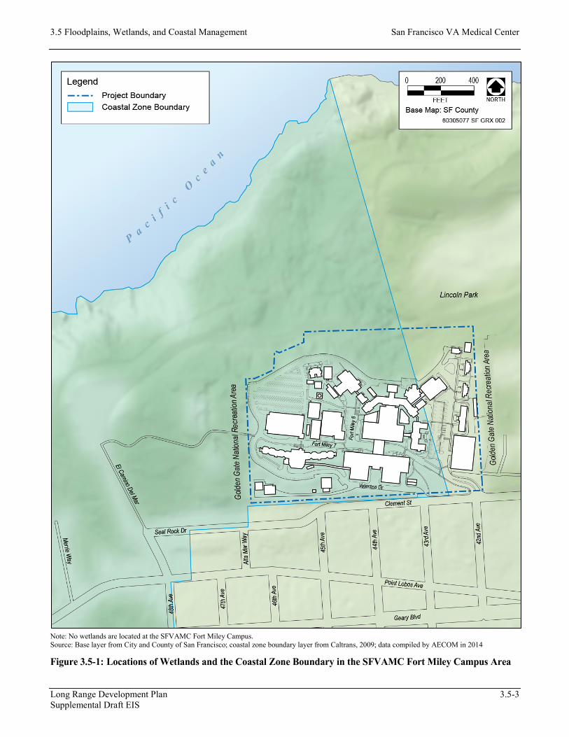
No wetlands or waters of the United States (streams, rivers, lakes) occur on or near the existing SFVAMC Fort Miley Campus (USFWS, 2010) (Figure 3.5-1).
Mission Bay Area
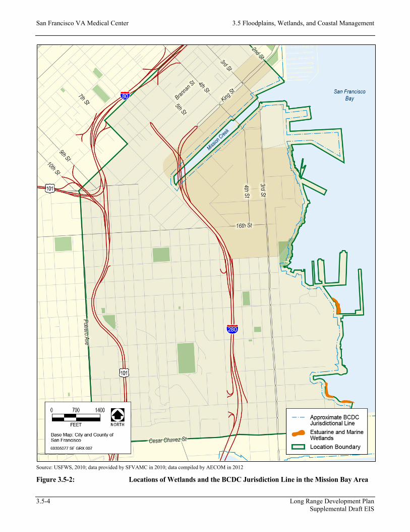
Several places in the Mission Bay area have been mapped by the U.S. Fish and Wildlife Service (USFWS) as having estuarine and marine wetlands (Figure 3.5-2). These sites are all located along San Francisco Bay and are considered waters of the United States under the Clean Water Act.
Coastal Management
Existing SFVAMC Fort Miley Campus
Most of the SFVAMC Fort Miley Campus, primarily the west side (approximately 24.4 acres, or 84 percent), is located within the boundaries of the California Coastal Zone (Figure 3.5-1). The California Coastal Zone is under the jurisdiction of the California Coastal Commission (CCC). However, the easternmost portion of the Campus, which includes existing Buildings 7, 8, 9, 10, 11, 32, 212, and part of Building 5, is not mapped within the coastal zone. The California Coastal Zone, which was established by the California Coastal Act, varies in width from several hundred feet in highly urbanized areas to up to 5 miles in certain rural areas of California. Offshore, the coastal zone includes a 3-mile-wide band of ocean.
Mission Bay Area
The coastal zone established by the California Coastal Act does not include San Francisco Bay. The San Francisco Bay Conservation and Development Commission (BCDC) is the federally designated State coastal management agency for the shoreline areas of the bay to the Golden Gate (Point Bonita–Point Lobos). This designation empowers BCDC to use the authority of the federal Coastal Zone Management Act to ensure that federal projects and activities are consistent with the policies of the San Francisco Bay Plan and State law. The coastal portions of the Mission Bay area are located within BCDC’s area of jurisdiction, which includes the first 100 feet shoreward from the line of highest tidal action (mean high-tide line) around San Francisco Bay (Figure 3.5-2).
3.5 Floodplains, Wetlands, and Coastal Management San Francisco VA Medical Center
Long Range Development Plan 3.5-3 Supplemental Draft EIS
Note: No wetlands are located at the SFVAMC Fort Miley Campus. Source: Base layer from City and County of San Francisco; coastal zone boundary layer from Caltrans, 2009; data compiled by AECOM in 2014
Figure 3.5-1: Locations of Wetlands and the Coastal Zone Boundary in the SFVAMC Fort Miley Campus Area
San Francisco VA Medical Center 3.5 Floodplains, Wetlands, and Coastal Management
3.5-4 Long Range Development Plan Supplemental Draft EIS
Source: USFWS, 2010; data provided by SFVAMC in 2010; data compiled by AECOM in 2012
Figure 3.5-2: Locations of Wetlands and the BCDC Jurisdiction Line in the Mission Bay Area
3.5 Floodplains, Wetlands, and Coastal Management San Francisco VA Medical Center
Long Range Development Plan 3.5-5 Supplemental Draft EIS
Regulatory Framework
Clean Water Act Section 404
Pursuant to Section 404 of the Clean Water Act, the U.S. Army Corps of Engineers (USACE) regulates temporary and permanent fill and disturbance of wetlands and waters of the United States. Waters of the United States are defined in the Code of Federal Regulations (CFR) (33 CFR 328.3[a], 40 CFR 230.3[s]) as follows:
(1) All waters that are currently used, or were used in the past, or may be susceptible to use in interstate or foreign commerce, including all waters that are subject to the ebb and flow of the tide;
(2) All interstate waters including interstate wetlands;
(3) All other waters such as intrastate lakes, rivers, streams (including intermittent streams), mudflats, sandflats, wetlands, sloughs, prairie potholes, wet meadows, playa lakes, or natural ponds, the use, degradation or destruction of which could affect interstate or foreign commerce including such waters:
(i) Which are or could be used by interstate or foreign travelers for recreational or other purposes; or
(ii) From which fish or shellfish are or could be taken and sold in interstate or foreign commerce; or
(iii) Which are used or could be used for industrial purposes by industries in interstate commerce;
(4) All impoundments of waters otherwise defined as waters of the United States under the definition;
(5) Tributaries of waters identified in paragraphs (1)–(4) of this section;
(6) The territorial seas; and
(7) Wetlands adjacent to waters (other than waters that are themselves wetlands) identified in paragraphs (1)–(6) of this section.
USACE (47 Federal Register [FR] 31810, July 22, 1982) and the U.S. Environmental Protection Agency (45 FR 85344, December 24, 1980, as amended at 58 FR 45037, August 25, 1993) jointly define wetlands as follows:
…those areas that are inundated or saturated by surface or ground water at a frequency and duration sufficient to support, and that under normal circumstances do support, a prevalence of vegetation typically adapted for life in saturated soil conditions. Wetlands generally include swamps, marshes, bogs, and similar areas (33 CFR 328.3[b]; 40 CFR 230.3[t]).
Under Section 404, the discharge (temporary or permanent) of dredged or fill material into waters of the United States, including wetlands, typically must be authorized by USACE through either the Nationwide Permit (general categories of discharges with minimal effects) or the Individual Permit.
San Francisco VA Medical Center 3.5 Floodplains, Wetlands, and Coastal Management
3.5-6 Long Range Development Plan Supplemental Draft EIS
Because there are no streams or water bodies on the existing SFVAMC Fort Miley Campus, no federal permit would be required for Alternative 1 or Alternative 2 projects, or for Alternative 3 short-term projects. Waters of the United States have been mapped for the Mission Bay area; therefore, Alternative 3 long-term projects (the potential new SFVAMC Mission Bay Campus) may require a federal permit, depending on the locations of those projects. Compliance with Section 404 requirements also would be required. A Section 401 certification (or waiver) would be required for any discharge regulated under Section 404.
Executive Order 11988—Floodplain Management Act
Executive Order 11988 was issued in 1977 in furtherance of NEPA, the National Flood Insurance Act of 1968, and the Flood Disaster Protection Act of 1973. The intent of this executive order is to avoid to the extent possible the long- and short-term adverse impacts of the occupancy and modification of floodplains, and to avoid direct or indirect support of floodplain development wherever there is a practicable alternative.
Agencies are to use maps prepared by the Federal Insurance Administration of FEMA (FIRMs or Flood Hazard Boundary Maps) to determine whether a proposed action is located in or would likely affect a floodplain. If no floodplain impact is identified, the action may proceed without further consideration. If the agency determines that a proposed action is located in or would affect a floodplain, a floodplain assessment must be undertaken and included in the EIS. If there is no practicable alternative to locating in or affecting the floodplain, the agency must act to minimize potential harm to the floodplain. The agency also must act to restore and preserve the natural and beneficial values of floodplains as part of the analysis of all alternatives under consideration.
Alternative 3 long-term projects would be required to comply with Executive Order 11988 if construction would occur within the floodplain.
Executive Order 11990—Protection of Wetlands
Executive Order 11990 was issued in 1977 in furtherance of NEPA, to avoid to the extent possible the long- and short-term adverse impacts of the destruction or modification of wetlands, and to avoid direct or indirect support of new construction in wetlands wherever there is a practicable alternative.
Agencies are to use maps prepared by USFWS (National Wetlands Inventory Maps) to determine whether a proposed action is located in or would likely affect wetlands. If no wetlands impact is identified, the action may proceed without further consideration. If the agency determines that a proposed action is located in or would affect wetlands, a wetland assessment must be undertaken and included in the EIS. If there is no practicable alternative to locating in or affecting wetlands, the agency must act to minimize potential harm to the wetlands. The agency also must act to restore and preserve the natural and beneficial values of wetlands as part of the analysis of all alternatives under consideration.
Alternative 3 long-term projects would be required to comply with Executive Order 11990 if a portion of a selected site would be built within mapped estuarine or marine wetlands.
3.5 Floodplains, Wetlands, and Coastal Management San Francisco VA Medical Center
Long Range Development Plan 3.5-7 Supplemental Draft EIS
Coastal Zone Management Act
The U.S. Congress approved the Coastal Zone Management Act (CZMA) in 1972. The CZMA, administered by the National Oceanic and Atmospheric Administration’s Office of Ocean and Coastal Resource Management, provides for management of the nation’s coastal resources, including the Great Lakes, and balances economic development with environmental conservation.
The CZMA outlines two national programs, the National Coastal Zone Management Program and the National Estuarine Research Reserve System. The 34 coastal programs aim to balance competing land and water issues in the coastal zone, while estuarine reserves serve as field laboratories to provide a greater understanding of estuaries and how humans affect them. The overall program objectives of CZMA remain balanced to “preserve, protect, develop, and where possible, to restore or enhance the resources of the nation’s coastal zone.”
Coastal states prepare coastal management programs under the CZMA. Once the federal government approves a state’s coastal management program, that state gains federal consistency-review authority. California’s Coastal Management Program, federally approved in 1977, designates two coastal zone management agencies to implement the federal consistency provisions: (1) CCC for all coastal areas outside San Francisco Bay; and (2) BCDC for the coastal areas along San Francisco Bay. CCC’s mission is to “Protect, conserve, restore, and enhance environmental and human-based resources of the California coast and ocean for environmentally sustainable and prudent use by current and future generations.” BCDC has jurisdiction over the open water, marshes, and mudflats of greater San Francisco Bay, including Suisun, San Pablo, Honker, Richardson, San Rafael, San Leandro, and Grizzly Bays and the Carquinez Strait, as well as the first 100 feet inland from the shoreline around San Francisco Bay. BCDC’s mission statement states that BCDC “is dedicated to the protection and enhancement of San Francisco Bay and to the encouragement of the Bay’s responsible use.” Any portion of the Mission Bay area located within 100 feet from the San Francisco Bay shoreline is subject to the CZMA.
National Flood Insurance Program and Flood Disaster Protection Act
The National Flood Insurance Act of 1968 and the Flood Disaster Protection Act of 1973 were enacted to reduce the need for flood protection structures and to limit disaster relief costs by restricting development in floodplains. FEMA, created in 1979, is responsible for predicting hazards related to flooding events and forecasting the level of inundation under various conditions. As part of its duty to develop standards for delineating fluvial and coastal floodplains, FEMA provides information about flood hazard and inundation potential on FIRMs, and where appropriate, designates regions as special flood hazard areas. Special flood hazard areas are defined as areas that have a 1 percent chance of flooding in a given year. FEMA released a preliminary FIRM for the City and County of San Francisco on September 21, 2007, for review and technical comment only, and to provide the City with a tool for implementing a floodplain management program. FEMA is conducting a more detailed analysis of flood hazards associated with San Francisco Bay and will provide the City with a revised preliminary map based on that analysis (OCA, 2011).
FEMA also administers the National Flood Insurance Program (NFIP), a federal program that enables property owners in participating communities to purchase insurance as protection against flood losses in exchange for state and community floodplain management regulations that reduce future flood damages. The City applied to FEMA to join the NFIP in fall 2008; FEMA approved the application for participation in April 2010. The NFIP
San Francisco VA Medical Center 3.5 Floodplains, Wetlands, and Coastal Management
3.5-8 Long Range Development Plan Supplemental Draft EIS
requirements are relevant because preliminary FEMA flood zones may be established in the Mission Bay area where portions of the Alternative 3 long-term projects could be located.
San Francisco Floodplain Management Ordinance
Even though the San Francisco Floodplain Management Ordinance is not a federal requirement, it was adopted based on the fact that FEMA has not yet published a final FIRM for areas located within the City and County of San Francisco. Thus, this local floodplain management ordinance is applicable to the alternatives analyzed in this EIS.
The San Francisco Board of Supervisors adopted the Floodplain Management Ordinance (Ordinance No. 188-08) as a condition of the City joining the NFIP. The ordinance requires that new or substantially improved structures located in special flood hazard areas be protected against flood damage, and prohibits uses that would increase flood risks (CCSF, 2008b). In general, the Floodplain Management Ordinance requires that the first floor of structures in flood zones be constructed above the floodplain or be flood-proofed. The ordinance also incorporates FEMA’s more stringent floodplain management requirements, which must be applied in areas where FIRMs show base flood elevations. If portions of the Alternative 3 long-term projects would be located within flood hazard areas in the Mission Bay area, the Floodplain Management Ordinance would be applicable. The Floodplain Management Ordinance is not applicable to Alternative 1, 2, or 3 short-term projects because such projects would occur at the existing SFVAMC Fort Miley Campus and would not be located in a special flood hazard area.
San Francisco Waterfront Special Area Plan
The San Francisco Waterfront Special Area Plan (Special Area Plan), last amended in February 2010, contains both general and geography-specific policies to facilitate nonmaritime, maritime, commercial, and recreational shoreline development along the San Francisco waterfront. The area covered by the Special Area Plan is the land and water area located along the existing shoreline of the City and County of San Francisco from the Hyde Street Pier through India Basin, including all areas within the jurisdiction of the Port of San Francisco. If portions of Alternative 3 long-term projects would be located within the area covered by the Special Area Plan, the Special Area Plan would be applicable. The policies contained in the Special Area Plan also apply to areas within BCDC jurisdiction for permit purposes. These policies are the basis for BCDC permit decisions and for federal consistency review under the federal Coastal Zone Management Act of 1972, as amended. The existing SFVAMC Fort Miley Campus is not located within the Special Area Plan or within BCDC jurisdiction. Therefore, the Special Area Plan is not applicable to the Alternative 1, 2, or 3 short-term projects.
Port of San Francisco Waterfront Land Use Plan
The Port of San Francisco Waterfront Land Use Plan (Waterfront Land Use Plan), adopted by the Port Commission in 1997, governs land use policy for waterfront lands under jurisdiction of the Port of San Francisco, a 7½-mile band that extends from Fisherman’s Wharf to India Basin. The Waterfront Land Use Plan is intended to serve as a balanced and implementable land use plan for the use and development of the Port of San Francisco’s waterfront. Since the Port Commission’s adoption of the plan in 1997, the City has approved amendments to the City General Plan and San Francisco Planning Code to allow project implementation consistent with the Waterfront Land Use Plan. In addition, amendments to BCDC’s plans and policies were

3.5 Floodplains, Wetlands, and Coastal Management San Francisco VA Medical Center
Long Range Development Plan 3.5-9 Supplemental Draft EIS
adopted. If portions of the Alternative 3 long-term projects would be located in the area covered by the Waterfront Land Use Plan, the Waterfront Land Use Plan would be applicable. The existing SFVAMC Fort Miley Campus is not located in the area covered by the Waterfront Land Use Plan. Therefore, the Waterfront Land Use Plan is not applicable to the Alternative 1, 2, and 3 short-term projects.
3.5.2 Environmental Consequences
Significance Criteria
A NEPA evaluation must consider the context and intensity of the environmental effects that would be caused by, or result from, the EIS Alternatives.
An Alternative analyzed in this EIS is considered to result in an adverse impact related to floodplains, wetlands, and coastal management if it would:
• result in substantive undesirable flooding impacts as a result of location within a floodplain;
• have a substantial adverse effect on federally protected wetlands as defined by Section 404 of the Clean Water Act (including, but not limited to, marsh, vernal pool, coastal, etc.) through direct removal, filling, hydrological interruption, or other means; or
• have a substantial adverse effect, either directly or indirectly, on coastal resources through increased erosion or water quality degradation.
Assessment Methods
The aforementioned significance criteria were applied to determine impact significance using a qualitative approach. Specifically, the following is a discussion of impacts associated with potential wetland or coastal resource alterations and flooding hazards in the floodplain, as well as conformance with applicable regulatory standards for the construction and operation of the SFVAMC LRDP.
Alternative 1: SFVAMC Fort Miley Campus Buildout Alternative
Short-Term Projects
Construction
The construction of Alternative 1 short-term projects would occur in 17 projects over approximately 7 years. Alternative 1 short-term projects would involve construction of 600,992 gross square feet (gsf) (384,452 of which would be net new gsf) at the existing SFVAMC Fort Miley Campus (Table 2-1 and Figure 2-1). New construction and building demolition for Alternative 1 short-term projects would occur within the coastal zone, with the exception of construction of Buildings 22, 23, and 24 and demolition of Building 20. Retrofitting of existing Buildings 1, 5, and 6 would also occur within the coastal zone. Construction, demolition, and retrofitting activities could result in short-term degradation of coastal resources including water quality, scenic resources and views, parking and coastal access, and habitat.
San Francisco VA Medical Center 3.5 Floodplains, Wetlands, and Coastal Management
3.5-10 Long Range Development Plan Supplemental Draft EIS
Wetlands Alteration
There are no wetlands or waters of the United States on or near the existing SFVAMC Fort Miley Campus that could be disturbed. As a result, no construction-related wetlands impact would result from implementation of Alternative 1 short-term projects.
Degradation of Coastal Resources
As defined in Section 304 of the federal Coastal Zone Management Act of 1972, the term “coastal zone” does not include “lands the use of which is by law subject solely to the discretion of or which is held in trust by the federal government.” The existing SFVAMC Fort Miley Campus is adjacent to the Golden Gate National Recreation Area (operated by the National Park Service). VA recognizes that actions outside the coastal zone may affect land or water uses or natural resources along the coast, and VA will make all reasonable attempts to achieve consistency with the provisions of the Coastal Zone Management Act.
Most of the SFVAMC Fort Miley Campus, primarily the west side (approximately 24.4 acres, or 84 percent), is located within the California Coastal Zone boundary (Figure 3.5-1); however, construction-related impacts of Alternative 1 short-term projects would be minimal and would not be expected to affect any coastal use or resource. For a discussion of construction-related impacts of short-term projects as they relate to additional coastal management topics (scenic resources and views, parking and coastal access, and habitat), see Section 3.1, “Aesthetics”; Section 3.13, “Transportation, Traffic, Circulation, and Parking”; and Section 3.15, “Wildlife and Habitat.” For further discussion regarding coast resources, see Appendix H, which contains the Coastal Consistency Determination for the LRDP at the Fort Miley Campus as submitted to CCC for concurrence.
As described in Section 3.8, “Hydrology and Water Quality,” Alternative 1 short-term projects would be required to comply with the requirements of Article 4.1 of the San Francisco Public Works Code, which regulates the quantity and quality of discharges to the combined sewer system. Most stormwater runoff from the project site would be collected and treated at the Oceanside Water Pollution Control Plant before discharge to the Pacific Ocean, and therefore would meet the effluent discharge limitations set by the plant’s National Pollutant Discharge Elimination System permit. As stormwater from part of the project site discharges to the small separate storm drainage system on the north side of the existing SFVAMC Fort Miley Campus along the north-facing slope, the project would be required to apply for coverage under the Construction General Permit (Order 2009-0009-DWQ, as amended by 2010-0014-DWQ and 2012-006-DWQ), which requires the development and implementation of a storm water pollution prevention plan (SWPPP) to reduce project-related pollution of surface water throughout the construction period. The SFVAMC would also be required to apply for a Construction Site Runoff Control Permit from the SFPUC and submit a copy of the SWPPP. A separate erosion and sediment control plan (ESCP) would not be required by the SFPUC if a copy of the SWPPP is submitted.
Construction-related water quality impacts would be minor because Alternative 1 short-term projects would comply with required permits; SWPPPs would be prepared and implemented; and VA Specification Section 015719, “Temporary Environmental Controls,” would be implemented. For additional discussion of water quality considerations during construction of Alternative 1 short-term projects, see Section 3.8, “Hydrology and Water Quality.”
3.5 Floodplains, Wetlands, and Coastal Management San Francisco VA Medical Center
Long Range Development Plan 3.5-11 Supplemental Draft EIS
Operation
Flooding as a Result of Location within a Floodplain
Because the existing SFVAMC Fort Miley Campus is not situated within a designated floodplain, no flooding impact would result from locating short-term projects within a floodplain. See Section 3.8, “Hydrology and Water Quality,” for a discussion of runoff and flooding.
Degradation of Wetlands
Because no wetlands or waters of the United States that could be degraded are located on or near the existing SFVAMC Fort Miley Campus, no impact related to wetlands alteration would result from implementation of short-term projects.
Degradation of Coastal Resources
Although most of the SFVAMC Fort Miley Campus, primarily the west side (approximately 24.4 acres, or 84 percent), is located within the California Coastal Zone boundary (see Figure 3.5-1), operational impacts of Alternative 1 short-term projects would be minimal. An increase in total or peak runoff volume from the site relative to existing conditions could contribute to the frequency or severity of combined sewer overflow (CSO) events discharged to the Pacific Ocean. Implementing Alternative 1 short-term projects is anticipated to result in a maximum increase in impervious area of approximately 0.69 acre (a 4 percent increase in impervious area compared to existing conditions) on the existing SFVAMC Fort Miley Campus. Implementing these proposed projects would result in minimal alterations to the site’s runoff conditions as the vast majority (95 percent) would occur within the existing development footprint of the Campus, primarily on existing impervious sites (i.e., existing paved parking areas and buildings).
As described in Section 3.8, “Hydrology and Water Quality,” implementing Management Measure HYD-1 at the existing SFVAMC Fort Miley Campus would ensure that infrastructure would be properly sized to handle stormwater and wastewater flows to protect from down-gradient flooding hazards that could affect the coastal zone. In addition, Low Impact Development (LID) techniques to infiltrate, evaporate, and detain stormwater would be used as required for compliance with Section 438 of the federal Energy Independence and Security Act and Article 4.2 of the San Francisco Public Works Code. Using LID techniques would ensure that predevelopment stormwater runoff conditions would be maintained. Thus, implementing Alternative 1 short-term projects would not contribute to the frequency or severity of CSO events and/or downstream flooding. This impact would be minor.
For a discussion of operational impacts of short-term projects as they relate to additional coastal management topics (scenic resources and views, parking and coastal access, and habitat), see Section 3.1, “Aesthetics”; Section 3.13, “Transportation, Traffic, Circulation, and Parking”; and Section 3.15, “Wildlife and Habitat.” For further discussion regarding coast resources, see Appendix H, which contains the Coastal Consistency Determination for the LRDP at the Fort Miley Campus as submitted to CCC for concurrence.
San Francisco VA Medical Center 3.5 Floodplains, Wetlands, and Coastal Management
3.5-12 Long Range Development Plan Supplemental Draft EIS
Long-Term Projects
Construction
The Alternative 1 long-term project would involve one project for Building 213 (Clinical Addition Building) that would occur over 24 months. The Alternative 1 long-term project would involve construction of 170,000 gsf, which would all be net new gsf at the existing SFVAMC Fort Miley Campus (Table 2-2 and Figure 2-2). New construction associated with the Alternative 1 long-term project would occur within the coastal zone on the site of the existing Building 12, which would be demolished as part of this Alternative’s short-term projects. Although construction activities associated with Building 213 would occur on a previously disturbed site (encompassing approximately 0.25 acre), such construction activities could result in short-term degradation of coastal resources including water quality, visual resources, traffic, and habitat.
Wetlands Alteration
There are no wetlands or waters of the United States on or near the existing SFVAMC Fort Miley Campus that could be disturbed. As a result, no construction-related wetlands impact would result from implementation of the Alternative 1 long-term project.
Degradation of Coastal Resources
Similar to the impacts of Alternative 1 short-term projects, construction-related impacts of the Alternative 1 long-term project would be minimal even though most of the SFVAMC Fort Miley Campus, primarily the west side (approximately 24.4 acres, or 84 percent), is located within the boundaries of the California Coastal Zone (Figure 3.5-1). Construction-related water quality impacts on the Pacific Ocean would be minor because the Alternative 1 long-term project would comply with the requirements of Articles 4.1 and 4.2 of the San Francisco Public Works Code and with required permits; SWPPPs would be prepared and implemented; and VA Specification Section 015719, “Temporary Environmental Controls,” would be implemented. For additional discussion of water quality considerations during construction of the Alternative 1 long-term project, see Section 3.8, “Hydrology and Water Quality.”
For a discussion of construction-related impacts of long-term projects as they relate to additional coastal management topics (scenic resources and views, parking and coastal access, and habitat), see Section 3.1, “Aesthetics”; Section 3.13, “Transportation, Traffic, Circulation, and Parking”; and Section 3.15, “Wildlife and Habitat.” For further discussion regarding coast resources, see Appendix H, which contains the Coastal Consistency Determination for the LRDP at the Fort Miley Campus as submitted to CCC for concurrence.
Operation
Flooding as a Result of Location within a Floodplain
Because the existing SFVAMC Fort Miley Campus is not situated within a designated floodplain, no flooding impact would result from locating long-term projects within a floodplain. See Section 3.8, “Hydrology and Water Quality,” for a discussion of runoff and flooding.
3.5 Floodplains, Wetlands, and Coastal Management San Francisco VA Medical Center
Long Range Development Plan 3.5-13 Supplemental Draft EIS
Degradation of Wetlands
Because no wetlands or waters of the United States that could be degraded are located on or near the existing SFVAMC Fort Miley Campus, no impact would result from implementation of the Alternative 1 long-term project.
Degradation of Coastal Resources
Implementing the Alternative 1 long-term project is not anticipated to result in any increase in impervious area on the existing SFVAMC Fort Miley Campus, because the proposed Building 213 would be constructed on the existing footprint of Building 12, which is planned for demolition as part of the short-term projects. Similar to the impacts of Alternative 1 short-term projects, implementing the Alternative 1 long-term project would result in minimal alterations to the site’s runoff conditions because the project would occur within the existing development footprint of the Campus, on an existing impervious site.
In addition, as described in Section 3.8, “Hydrology and Water Quality,” implementing Management Measure HYD-1 at the existing SFVAMC Fort Miley Campus would ensure that infrastructure would be properly sized to handle stormwater and wastewater flows to protect against down-gradient flooding hazards that could affect the coastal zone. Furthermore, LID techniques would be used to infiltrate, evaporate, and detain stormwater as required for compliance with Section 438 of the U.S. Energy Independence and Security Act. Using LID techniques would ensure that predevelopment stormwater runoff conditions would be maintained. Thus, implementing the Alternative 1 long-term project would not contribute to the frequency or severity of CSO events and/or downstream flooding. This impact would be minor.
For additional discussion of water quality considerations during operation of the Alternative 1 long-term project, see Section 3.8, “Hydrology and Water Quality.” For a discussion of operational impacts of the long-term project as it relates to additional coastal management topics (scenic resources and views, parking and coastal access, and habitat), see Section 3.1, “Aesthetics”; Section 3.13, “Transportation, Traffic, Circulation, and Parking”; and Section 3.15, “Wildlife and Habitat.” For further discussion regarding coast resources, see Appendix H, which contains the Coastal Consistency Determination for the LRDP at the Fort Miley Campus as submitted to CCC for concurrence.
Alternative 2: SFVAMC Fort Miley Campus Buildout Alternative
Short-Term Projects
Alternative 2 short-term projects at the existing SFVAMC Fort Miley Campus would be the same as Alternative 1 short-term projects, with one exception. Specifically, retrofitting of the existing Buildings 1, 6, and 8 would not occur as part of Alternative 2 short-term projects (Table 2-3 and Figure 2-3), but would instead be accomplished in the long term. The construction of Alternative 2 short-term projects would occur in 16 projects over 6 years. Alternative 2 short-term projects would involve construction of a total of 485,445 gsf, which is 115,547 gsf less than for Alternative 1 short-term projects. Therefore, impacts of Alternative 2 short-term projects would be similar to or less than those of Alternative 1 short-term projects. Any impacts on floodplains, wetlands, and coastal management would range from minor to no impact).
San Francisco VA Medical Center 3.5 Floodplains, Wetlands, and Coastal Management
3.5-14 Long Range Development Plan Supplemental Draft EIS
Construction
Wetlands Alteration
There are no wetlands or waters of the United States on or near the existing SFVAMC Fort Miley Campus that could be disturbed. As a result, no construction-related impact on wetlands would result from implementation of Alternative 2 short-term projects.
Degradation of Coastal Resources
Like the impacts of Alternative 1 short-term projects, construction-related impacts of Alternative 2 short-term projects would be minimal even though a portion of the site is located within the Coastal Zone Management Area. Construction-related water quality impacts on the Pacific Ocean would be minor because Alternative 2 short-term projects would comply with the requirements of Articles 4.1 and 4.2 of the San Francisco Public Works Code and with required permits; SWPPPs would be prepared and implemented; and VA Specification Section 015719, “Temporary Environmental Controls,” would be implemented. For additional discussion of water quality considerations during construction of the Alternative 2 short-term projects, see Section 3.8, “Hydrology and Water Quality.”
For a discussion of construction-related impacts of short-term projects as they relate to additional coastal management topics (scenic resources and views, parking and coastal access, and habitat), see Section 3.1, “Aesthetics”; Section 3.13, “Transportation, Traffic, Circulation, and Parking”; and Section 3.15, “Wildlife and Habitat.” For further discussion regarding coastal resources, see Appendix H, which contains the Coastal Consistency Determination for the LRDP at the Fort Miley Campus as submitted to CCC for concurrence.
Operation
Flooding as a Result of Location within a Floodplain
Because the existing SFVAMC Fort Miley Campus is not situated within a designated floodplain, no flooding impact would result from locating short-term projects within a floodplain. See Section 3.8, “Hydrology and Water Quality,” for a discussion of runoff and flooding.
Degradation of Wetlands
Because no wetlands or waters of the United States that could be degraded are located on or near the existing SFVAMC Fort Miley Campus, no impact would result from implementation of Alternative 2 short-term projects.
Degradation of Coastal Resources
Implementing Alternative 2 short-term projects is anticipated to result in a maximum increase in impervious area of approximately 0.69 acre (a 4 percent increase in impervious area compared to existing conditions) on the existing SFVAMC Fort Miley Campus. As with Alternative 1 short-term projects, implementing Alternative 2 short-term projects would result in minimal alterations to the site’s runoff conditions because the projects would occur within the Campus’s existing development footprint, primarily on existing impervious sites (i.e., paved parking areas and buildings). For the same reasons as discussed above for Alternative 1 short-term projects,
3.5 Floodplains, Wetlands, and Coastal Management San Francisco VA Medical Center
Long Range Development Plan 3.5-15 Supplemental Draft EIS
implementing Alternative 2 short-term projects would not contribute to the frequency or severity of CSO events and/or downstream flooding. This impact would be minor.
As described in Section 3.8, “Hydrology and Water Quality,” implementing Management Measure HYD-1 at the existing SFVAMC Fort Miley Campus would ensure that infrastructure would be properly sized to handle stormwater and wastewater flows to protect from down-gradient flooding hazards that could affect the coastal zone. In addition, LID techniques to infiltrate, evaporate, and detain stormwater would be used as required for compliance with Section 438 of the federal Energy Independence and Security Act and Article 4.2 of the San Francisco Public Works Code. Using LID techniques would ensure that predevelopment stormwater runoff conditions would be maintained. Thus, implementing Alternative 2 short-term projects would not contribute to the frequency or severity of CSO events and/or downstream flooding. This impact would be minor.
For additional discussion of water quality considerations during operation of short-term projects for Alternative 2, see Section 3.8, “Hydrology and Water Quality.” For a discussion of operational impacts of short-term projects as they relate to additional coastal management topics (scenic resources and views, parking and coastal access, and habitat), see Section 3.1, “Aesthetics”; Section 3.13, “Transportation, Traffic, Circulation, and Parking”; and Section 3.15, “Wildlife and Habitat.” For further discussion of coastal resources, see Appendix H, which contains the Coastal Consistency Determination for the LRDP at the Fort Miley Campus as submitted to CCC for concurrence.
Long-Term Projects
Alternative 2 long-term projects at the existing SFVAMC Fort Miley Campus would be the same as the Alternative 1 long-term project, with one exception. Specifically, three additional existing buildings—Buildings 1, 6, and 8—would be retrofitted as part of Alternative 2 long-term projects (Table 2-4 and Figure 2-4). Alternative 2 long-term projects would involve construction of a total of 285,487 gsf, which is 115,487 gsf more than under the Alternative 1 long-term project, because Alternative 2 includes construction of Building 213 along with the seismic retrofit of Buildings 1, 6, and 8. Therefore, construction impacts of Alternative 2 long-term projects would be similar to, although slightly greater than, those of the Alternative 1 long-term project. Any impacts on floodplains, wetlands, and coastal management would range from minor to no impact.
Construction
Wetlands Alteration
There are no wetlands or waters of the United States on or near the existing SFVAMC Fort Miley Campus that could be disturbed. As a result, no construction-related impact on wetlands would result from implementation of Alternative 2 long-term projects.
Degradation of Coastal Resources
Like the impacts of Alternative 2 short-term projects, construction-related impacts of Alternative 2 long-term projects would be minimal even though most of the SFVAMC Fort Miley Campus, primarily the west side (approximately 24.4 acres, or 84 percent), is located within the California Coastal Zone boundary (Figure 3.5-1). For the same reasons as discussed above for the Alternative 1 long-term project, construction-related water
San Francisco VA Medical Center 3.5 Floodplains, Wetlands, and Coastal Management
3.5-16 Long Range Development Plan Supplemental Draft EIS
quality impacts of Alternative 2 long-term projects on the Pacific Ocean would be minor. For additional discussion of water quality considerations during construction of Alternative 2 long-term projects, see Section 3.8, “Hydrology and Water Quality.”
For a discussion of construction-related impacts of long-term projects as they relate to additional coastal management topics (scenic resources and views, parking and coastal access, and habitat), see Section 3.1, “Aesthetics”; Section 3.13, “Transportation, Traffic, Circulation, and Parking”; and Section 3.15, “Wildlife and Habitat.” For further discussion regarding coast resources, see Appendix H, which contains the Coastal Consistency Determination for the LRDP at the Fort Miley Campus as submitted to CCC for concurrence
Operation
Flooding as a Result of Location within a Floodplain
Because the existing SFVAMC Fort Miley Campus is not situated within a designated floodplain, no flooding impact would result from locating long-term projects within a floodplain. See Section 3.8, “Hydrology and Water Quality,” for a discussion of runoff and flooding.
Degradation of Wetlands
Because no wetlands or waters of the United States that could be degraded are located on or near the existing SFVAMC Fort Miley Campus, no impact would result from implementation of Alternative 2 long-term projects.
Degradation of Coastal Resources
Implementing Alternative 2 long-term projects is not anticipated to result in any increase in impervious area on the existing SFVAMC Fort Miley Campus because the proposed Building 213 would be constructed on the existing footprint of Building 12, which is planned for demolition as part of the short-term projects. In addition, seismic retrofitting of Buildings 1, 6, and 8 would not result in any increase in impervious area at the Campus. As under the Alternative 1 long-term project, implementing Alternative 2 long-term projects would result in minimal alterations to the site’s runoff conditions because the projects would occur within the existing development footprint of the Campus, on existing impervious sites. Implementing Management Measure HYD-1 at the existing SFVAMC Fort Miley Campus would ensure that infrastructure would be properly sized to handle stormwater and wastewater flows to protect from down-gradient flooding hazards that could affect the coastal zone. In addition, LID techniques would be used to infiltrate, evaporate, and detain stormwater as required for compliance with Section 438 of the federal Energy Independence and Security Act. Using LID techniques would ensure that predevelopment stormwater runoff conditions would be maintained. Thus, implementing Alternative 2 long-term projects would not contribute to the frequency or severity of CSO events and/or downstream flooding. This impact would be minor.
For additional discussion of water quality considerations during operation of Alternative 2 long-term projects, see Section 3.8, “Hydrology and Water Quality.” For a discussion of operational impacts of short-term projects as they relate to additional coastal management topics (scenic resources and views, parking and coastal access, and habitat), see Section 3.1, “Aesthetics”; Section 3.13, “Transportation, Traffic, Circulation, and Parking”; and Section 3.15, “Wildlife and Habitat.” For further discussion regarding coast resources, see Appendix H, which contains the Coastal Consistency Determination for the LRDP at the Fort Miley Campus as submitted to CCC for concurrence.
3.5 Floodplains, Wetlands, and Coastal Management San Francisco VA Medical Center
Long Range Development Plan 3.5-17 Supplemental Draft EIS
Alternative 3: SFVAMC Fort Miley Campus plus Mission Bay Campus Alternative
Short-Term Projects
Alternative 3 short-term projects (during both construction and operation) would be the same as Alternative 1 short-term projects (Table 2-1 and Figure 2-1). Therefore, the impacts of Alternative 3 short-term projects would be the same as the impacts of Alternative 1 short-term projects. These impacts would be minor.
Long-Term Projects
Alternative 3 long-term projects, including the ambulatory care center and associated parking structure uses, would be located at the potential new SFVAMC Mission Bay Campus on approximately 0.98 acre (Table 2-5 and Figure 2-5). No additional construction would occur at the existing SFVAMC Fort Miley Campus under the Alternative 3 long-term projects.
Construction
Wetlands Alteration
Several locations in the Mission Bay area along San Francisco Bay have been mapped by USFWS as having estuarine and marine wetlands (Figure 3.5-2). Because the precise location of the potential new SFVAMC Mission Bay Campus is unknown at this time, development of the Alternative 3 long-term projects in the Mission Bay area could result in adverse impacts on estuarine and marine wetlands. If Alternative 3 long-term projects would be implemented within or near wetlands, construction-related wetland impacts would comply with Articles 4.1 and 4.2 of the San Francisco Public Works Code; SWPPPs would be prepared and implemented; and VA Specification Section 015719, “Temporary Environmental Controls,” would be implemented. If wetlands were to appear to be present within a proposed site, a qualified wetland biologist would conduct a wetlands assessment in compliance with Executive Order 11990, to determine the quantity and type that would be avoided or mitigated to the extent possible as part of a future project-level NEPA review. This impact would remain potentially adverse.
Degradation of Coastal Resources
Because the precise location of the Alternative 3 long-term projects at the potential new SFVAMC Mission Bay Campus is unknown at this time, development of projects in the Mission Bay area has the potential to result in adverse coastal management impacts. If development under Alternative 3 would occur on a site situated within 100 feet of San Francisco Bay, a consistency determination would be obtained from BCDC before commencement of construction and the construction contractor would attempt to avoid the BCDC jurisdictional line. If development were to be proposed along the water’s edge of San Francisco Bay, an application would be submitted to BCDC for approval if any of the actions listed below would need to occur:
• placing solid material, building or repairing docks or pile-supported or cantilevered structures, disposing of material, or mooring a vessel for a long period in San Francisco Bay or in certain tributaries that flow into the bay;
• dredging or extracting material from the bay bottom;
• substantially changing the use of any structure or area;
San Francisco VA Medical Center 3.5 Floodplains, Wetlands, and Coastal Management
3.5-18 Long Range Development Plan Supplemental Draft EIS
• constructing, remodeling, or repairing a structure; or
• subdividing property or grading land.
If Alternative 3 is chosen for implementation, VA would coordinate with BCDC with regard to coastal resources if located within its jurisdiction. Through assumed compliance with the BCDC permit application and permitting requirements, impacts on coastal management are anticipated to be minor.
For a discussion of construction impacts of Alternative 3 long-term projects as they relate to additional coastal management topics, including scenic resources and views, parking and coastal access, and habitat, see Section 3.1, “Aesthetics”; Section 3.13, “Transportation, Traffic, Circulation, and Parking”; and Section 3.15, “Wildlife and Habitat.” For further discussion regarding coast resources, see Appendix H, which contains the Coastal Consistency Determination for the LRDP at the Fort Miley Campus as submitted to CCC for concurrence. For development within the California Coastal Zone, a consistency determination would be obtained from CCC before commencement of construction.
Operation
Flooding as a Result of Location within a Floodplain
The Alternative 3 long-term projects may be implemented in areas mapped as special flood hazard areas if they would be located along the shoreline of San Francisco Bay. If Alternative 3 long-term projects would be situated within a special flood hazard area, the projects would be required to comply with the requirements of the San Francisco Floodplain Management Ordinance. Specifically, the first floor of structures would have to be located above the floodplain or be flood-proofed. Through assumed compliance with the requirements of the Floodplain Management Ordinance, the flooding impact resulting from potential location within a floodplain would be minor.
Degradation of Wetlands
Several locations in the Mission Bay area along San Francisco Bay have been mapped by USFWS as having estuarine and marine wetlands. The precise location of the Alternative 3 long-term projects is unknown at this time; therefore, as discussed in Section 3.8, “Hydrology and Water Quality,” implementing Alternative 3 may result in adverse impacts on nearby estuarine and marine wetlands through downstream flooding or an increase in the frequency or severity of CSO events. However, implementing Management Measure HYD-1 at the potential new SFVAMC Mission Bay Campus would ensure that infrastructure would be properly sized to handle stormwater and wastewater flows to protect from down-gradient flooding hazards. In addition, LID or other techniques described in Management Measure HYD-1 would be used to infiltrate, evaporate, and detain stormwater, ensuring that predevelopment stormwater runoff conditions would be maintained. Thus, with implementation of Management Measure HYD-1, Alternative 3 long-term projects would not substantially contribute to the frequency or severity of CSO events and/or downstream flooding. Implementing this management measure would reduce operational wetland impacts to a minor level.
3.5 Floodplains, Wetlands, and Coastal Management San Francisco VA Medical Center
Long Range Development Plan 3.5-19 Supplemental Draft EIS
Degradation of Coastal Resources
If Alternative 3 is chosen for implementation, VA would coordinate with BCDC and impacts on coastal resources would be avoided or mitigated as part of a future project-level NEPA review. Through assumed compliance with the BCDC permit application and permitting requirements, impacts of Alternative 3 long-term projects related to coastal management are anticipated to be minor.
For a discussion of operational impacts of Alternative 3 as they relate to additional coastal management topics, including scenic resources and views, parking and coastal access, and habitat, see Section 3.1, “Aesthetics”; Section 3.13, “Transportation, Traffic, Circulation, and Parking”; and Section 3.15, “Wildlife and Habitat.” For further discussion regarding coast resources, see Appendix H, which contains the Coastal Consistency Determination for the LRDP at the Fort Miley Campus as submitted to CCC for concurrence. For development within the California Coastal Zone, a consistency determination would be obtained from CCC before commencement of construction.
Alternative 4: No Action Alternative
Short-Term and Long-Term Projects
Construction
Under Alternative 4, there would be no new construction or retrofitting of existing buildings. Therefore, no construction-related wetlands or coastal management impacts would occur.
Operation
Under Alternative 4, the LRDP would not be implemented. Therefore, no operational flooding, wetlands, or coastal management impacts would occur.
3.5.3 References
California Department of Transportation, TSI/GIS Data Branch (Caltrans). 2009. Draft Coastal Zone Boundary file (COASTZN), digitized in AutoCAD from the California Coastal Commission's original Coastal Zone Boundary map set, which has the U.S. Geological Survey 1:24,000 Quadrangle series as its base. Available: <https://projects.atlas.ca.gov/frs/download.php/10748/Coastal_Zone_Boundary_2007.zip>. Accessed January 7, 2015.
Office of the City Administrator (OCA). 2011. San Francisco Floodplain Management Program Fact Sheet. San Francisco, CA. Available: <http://sfgsa.org/Modules/ShowDocument.aspx?documentid=7520>. Accessed February 8, 2011.
San Francisco, City and County of (CCSF). 2008a. San Francisco Floodplain Management Program: San Francisco’s Interim Floodplain Maps, July 2008. Available: <http://sfgsa.org/index.aspx?page=828>. Accessed August 29, 2011.
San Francisco VA Medical Center 3.5 Floodplains, Wetlands, and Coastal Management
3.5-20 Long Range Development Plan Supplemental Draft EIS
———. 2008b. San Francisco Floodplain Management Program: Floodplain Management Ordinance, Legislative Ordinance–2008. Ordinance No. 188-08, June 5, 2008. Available: <http://sfgsa.org/index.aspx?page=828>. Accessed February 7, 2011.
U.S. Fish and Wildlife Service (USFWS). 2010. National Wetlands Inventory: Wetlands Mapper. Last updated October 1, 2010. Available: <http://www.fws.gov/wetlands/data/mapper.html>. Accessed August 29, 2011.
3.5 Floodplains, Wetlands, and Coastal Management San Francisco VA Medical Center
Long Range Development Plan 3.5-21 Supplemental Draft EIS
---For document production use only---
Table of Contents 3.5 Floodplains, Wetlands, and Coastal Management..................................................................... 3.5-1
Figures:
Figure 3.5-1: Locations of Wetlands and the Coastal Zone Boundary in the SFVAMC Fort Miley Campus Area .......................................................................................................................... 3.5-3
Figure 3.5-2: Locations of Wetlands and the BCDC Jurisdiction Line in the Mission Bay Area ............... 3.5-4
Tables:
No table of contents entries found.