Embed Size (px)
Citation preview

344 Journal of Basic & Applied Sciences, 2014, 10, 344-348
ISSN: 1814-8085 / E-ISSN: 1927-5129/14 © 2014 Lifescience Global
Satellite Image Identification of Wind Channels to Delineate Wind Energy Generation Sites in Pakistan
Zeeshan Alam Nayyara,* and Nayyer Alam Zaighamb
aNew Technologies Research Group, Department of Applied Physics, University of Karachi, Pakistan
bUnit for Ain Zubaida & Groundwater Research, King Abdulaziz University, Jeddah, Saudi Arabia
Abstract: Technologically, all the renewable energy sources are viable and consequently suit to efforts for poverty alleviation and cleaner environment in Pakistan. They can play an important role in meeting the challenge of providing
future electricity to all parts of the country. Wind energy is one of these renewable sources. Considering the geological & geomorphologic setup, geographical position and climatic cycles, Pakistan has tremendous wind potential. Pakistan has about 1000 km long coastline, which could be utilized for the installation of wind farms and wind-monitoring stations as
well. Various preliminary comparative studies apparently show that the wind potential is not uniformly distributed along the coastal belt of Pakistan. The present research study is based on the analyses of the satellite images of different periods. On the bases of the result of the study, the prospective wind channels have been identified all along the coastal
belt of Pakistan, which are the ideal regions to establish the wind farms for the generation of electricity on the commercial scale.
Keywords: Wind Energy, Wind Channels, Satellite Images, Energy Generation, Pakistan.
1. INTRODUCTION
Pakistan stretches from 24°N to 37°N latitudes and
from 61°E to 78°E longitudes. The total land area of
Pakistan is about 800,000 square kilometers (Figure 1).
The conventional energy sources, i.e. fossil fuels (such
as coal and petroleum and biofuels like wood), mega-
hydels, and nuclear plants have remained the main
energy sources of choice of the world for centuries.
Now, there has been a growing recognition, for more
than one reason, of the dangers inherent in continuing
with the model of economic development based on
these sources, particularly the excessive consumption
of fossil fuels. One reason is that the reserves of fossil
fuels are not unlimited and at the present rate of
consumption they would not last very long.
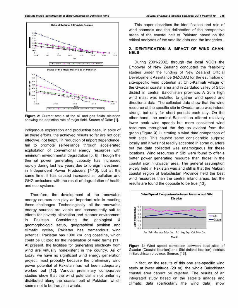
According to a research report [1] based on Ministry
of Petroleum and Natural Resources’ information,
Pakistan will be going to suffer energy crisis from 2014
because 10 of largest oil and natural gas reservoirs of
the country will be exhausted during 2014 to 2025,
includes Sui, Mari, Qadirpur, Bhat and Zamzama for
the natural gas and Pandori, Adhi, Kanar, Zoor and
Dhodhak for oil (Figure 2). Pakistan is producing 3,549
million cubic feet natural gas daily out of which 61.8
percent (2,194.8 million cubic feet) is acquires from the
five main gas fields. Right now the total oil production
of the country is about 58,805 barrels daily and 36.8
percent (21,615 barrels daily) out of it is produced by
these five main fields.
*Address correspondence to this author at the New Technologies Research Group, Department of Applied Physics, University of Karachi, Pakistan; Tel: +92 321 2812007; E-mail: [email protected]; [email protected]
Figure 1: Map shows the study area and the geomorphological features of Pakistan.
Yet another aspect that has come into sharp focus
is that the developing countries can ill afford to depend
excessively upon petroleum imports marked as they
are by volatile price fluctuations. Moreover,
indiscriminate use of fuel wood leads to deforestation
with consequent environmental hazards and inefficient
burning of fuel wood leads to an increase in indoor air
pollution and consequent health hazards especially for
women and children. Similarly, the other conventional
sources of energy generation have their adverse
impacts on environment [2-4].
Efforts have also been made to exploit the existing
conventional energy resources to build a strong
Satellite Image Identification of Wind Channels to Delineate Wind Journal of Basic & Applied Sciences, 2014 Volume 10 345
indigenous exploration and production base. In spite of
all these efforts, the achieved results so far are not cost
effective, not helpful in reduction of import dependence,
fail to promote self-reliance through accelerated
exploitation of conventional energy resources with
minimum environmental degradation [5, 6]. Though the
thermal power generating capacity has increased
rapidly during last few years due to foreign investment
in Independent Power Producers [7-10], but at the
same time, it has caused increased air pollution and
GHG emissions with the result of degradation of health
and eco-systems.
Therefore, the development of the renewable
energy sources can play an important role in meeting
these challenges. Technologically, all the renewable
energy sources are viable and consequently suit to
efforts for poverty alleviation and cleaner environment
in Pakistan. Considering the geological &
geomorphologic setup, geographical position and
climatic cycles, Pakistan has tremendous wind
potential. Pakistan has 1000 km long coastline, which
could be utilized for the installation of wind farms [11].
At present, the facilities for generating electricity from
wind are virtually nonexistent in the country. As of
today, we have no significant wind energy generation
project, most probably because the preliminary wind
power potential of Pakistan has not been adequately
worked out [12]. Various preliminary comparative
studies show that the wind potential is not uniformly
distributed along the coastal belt of Pakistan, which
seems not to be true as a whole.
This paper describes the identification and role of
wind channels and the delineation of the prospective
areas of the coastal belt of Pakistan based on the
critical analyses of the satellite data and the imageries.
2. IDENTIFICATION & IMPACT OF WIND CHAN-NELS
During 2001-2002, through the local NGOs the
Empower of New Zealand conducted the feasibility
studies under the funding of New Zealand Official
Development Assistance (NZODA) for the estimation of
site-specific wind potential at Chib-Kalmati village of
the Gwadar coastal area and in Zardaloo valley of Sibbi
district in central Balochistan province. A 20m high
wind mast was installed to gather wind speed and
directional data. The collected data show that the wind
resource at the specific site in Gwadar area was indeed
strong, but only for short periods each day. On the
other hand, the central Balochistan offered relatively
lower peak wind speeds but more consistent wind
resources throughout the day as evident from the
graph (Figure 3) illustrating a wind data comparison of
both sites. This caused some considerable surprise
locally and it was not readily accepted in some quarters
but the data collected was unambiguous for these
locations. Wind resources in Sibi were found to offer a
better power generating resource than those in the
coastal site in Gwadar area. The general assumption
widely held in Pakistan was and still is that the Makran
coastal region of Balochistan Province held the best
wind resources than the central inland areas, but the
results are found the opposite to be true [13].
Figure 3: Wind speed correlation between local sites of Gwadar (Coastal location) and Sibi (inland location) districts in Balochistan province. Source: [13].
In fact, on the results of this one site-specific wind
study at lower altitude (20 m), the whole Balochistan
coastal area cannot be rejected. The results of an
integrated study based on the satellite images and
climatic data (particularly the wind data) show
Figure 2: Current status of the oil and gas fields’ situation showing the depletion rate of major field. Source of Data: [1].

346 Journal of Basic & Applied Sciences, 2014 Volume 10 Nayyar and Zaigham
interesting pattern of wind distribution along the coastal
belt of the Balochistan province. The detailed research
study is in progress presently, but the preliminary
results of this study show that the wind blows in north-
south oriented channels, which can be identified based
on the comparative study of satellite images. Satellite
images from various sources/sensors including NASA’s
MODIS, NOAA’s AVHRR, SeaWIFS and Meteosat-5
have been acquired for the period of 5 years i.e. 2001
to 2004 [14-18].
Different analyses have been performed to enhance
the dust storms encapsulating the study area. For the
NOAA AVHRR images, both Visible and IR window
channels have been analyzed. Dust on the ground can
be detected via IR window images because of the
temperature difference and the dust over the ocean
can be identified by Visible window images because
the temperature contrast between water and dust
reduces and it cannot be seen by IR window images.
SeaWIFS images have the advantage of high spatial
resolution of about 1 km. The false-color composite
images of SeaWIFS use three channels; the 670 nm as
red, 555 nm as green and 412 nm as blue. For
example, a false-color satellite image from SeaWIFS
have been processed (Figure 4) and this image reveal
how the wind plumes originate from wind scouring over
small, dry lake beds in Afghanistan and spread over
the Arabian Sea covering the western Makran coast.
Unlike multispectral satellites like AVHRR and
SeaWIFS, Meteosat has only two channels that show
dust well: visible and longwave infrared. The Meteosat-
5 visible images give us dust patterns over the ocean,
while the combine (both the visible and the infrared)
color images from Meteosat gave us more
comprehensive result and eliminate the need to switch
between visible and infrared images.
Finally we have performed satellite image
processing on the NASA MODIS products acquired by
the NASA’s Terra satellite Moderate Resolution
Imaging Spectroradiometer (MODIS). The true-color
satellite scene (Figure 5) shows strong winds blowing
dust and sand from the Makran Mountains in
southwestern Pakistan and Iran out over the Arabian
Figure 4: On October 10, 2001, dust storm originating from the Afghanistan covering the western Makran coast (I=Indus Delta, K=Karachi, S=Sonmiani, O=Ormara, P=Pasni, G=Gwadar, J=Jiwani). Satellite image source: [17].
Figure 5: In early December 2003, strong winds were blowing dust and sand from the Makran Mountains in southwestern Pakistan and Iran out over the Arabian Sea, which have revealed the locations of the wind channels along the Balochistan coastal belt (K=Karachi, S=Sonmiani, O=Ormara, P=Pasni, G=Gwadar, J=Jiwani). Satellite image source: [15].
Figure 6: The true-color satellite scene shows a dust storm blowing along Pakistan’s southeastern coast and out over the Arabian Sea revealing the NE-SW oriented wind channel passing across the southern Sindh province on February 9, 2004 (TD= Thar Desert, I=Indus Delta, K=Karachi, S=Sonmiani, O=Ormara, P=Pasni). Satellite image source: [15].

Satellite Image Identification of Wind Channels to Delineate Wind Journal of Basic & Applied Sciences, 2014 Volume 10 347
Sea. The wind channels are evidently revealed due to
the presence of dust demarcating the prospective
areas for the detailed inland wind measurements to
study the wind consistency and potentiality for the
development of commercial wind farms all along the
Balochistan coastal area. Apparently, the areas from
western part of Karachi to Sonmiani extending
westward up to eastern part of Hingol, Ormara, the
area between Pasni and Gwadar, and the area
between western part of Gwadar and Jiwani, seem to
hold high wind potential.
Similarly, another satellite image (Figure 6) from
MODIS shows the dust blowing along Pakistan’s
southeastern coast and out over the Arabian Sea. The
northeast-southwest oriented significantly wide wind
channel is clearly revealed showing the existence of
high wind potential. This wind channel passes across
the coastal-deltaic region and the Thar Desertic areas
of southeastern Sindh province. This wind channel
seems to extend up to Rajasthan area of India.
During the present study, these satellite imageries
of different periods revel that the trend of dust storm
varies from region to region in the coastal areas of
Pakistan In Balochistan coastal area, the speed of the
dust storm is strong and moreover the dust storm
carries coarser sediments, which can create enormous
abrasion, attrition and other physical & mechanical
damages. On the other hand, in Sindh coastal area the
dust storms are relatively of low speed and carry finer
sediments. Such finer dust can in-house and stick the
sensitive parts of the wind turbines and other relevant
mechanical devices reducing their life, if adequate
system is not selected for the installation under specific
prevailing atmospheric environment.
In areas covered by these satellite images, no
detailed wind mapping has been done at the
appropriate altitudes, i.e. 50 m and above, which is
imperative for the successful development of the
commercial wind farms. Furthermore, the impact of
natural hazards like dust-storms should also monitor on
regular basis to improve the technology and its
outcome.
Based on the 50 m wind data acquired by the
NASA’s Goddard Earth Observing System - Version 1
(GEOS-1), another study is in progress. The study area
is spread from 22oN to 27
oN and 61
oE to 73
oE (Figure
1). The results of the initial plots of 10-years averages
of the wind velocity data of the Arabian Sea and the
coastal belt of Pakistan (Figure 7) show the presence
of high wind potential throughout the year except a
period from September to December. Since the
satellite data is of reconnoitry nature, a realistic wind
model can only be achieved through detailed inland
wind mapping, which is expected to be more
prospective.
3. CONCLUSION
The present study only covers the coastal areas of
Pakistan, which shows bright wind potentials to
undertake feasibility studies for the development of the
commercial wind energy generation facilities. The
climatic conditions and the geomorphological set ups
throughout the country are witness for the presence of
the high wind potentials in other parts of Pakistan.
The present study shows that the prospective sites
can be identified by utilizing satellite technology for
more detailed site-specific wind study in the areas
having relatively good winds rather than the whole
coastal belt of Pakistan.
Figure 7: Plots of Wind speed at 50m (m/s) – 10-years monthly averages. Data accuracy is 1.3 m/s (-0.2m/s). See Figure 1 for location of study area. Source of data: NASA GEOS-I.
348 Journal of Basic & Applied Sciences, 2014 Volume 10 Nayyar and Zaigham
The areas from western part of Karachi to Sonmiani
extending westward up to eastern part of Hingol,
Ormara, the area between Pasni and Gwadar, the area
between western part of Gwadar and Jiwani, the
coastal-deltaic region and the Thar Desertic areas of
southeastern Sindh province have been identified for
detailed wind potential study.
The impact of the dust-storms on the development
of wind energy technology should also consider
seriously taking maximum benefit.
REFERENCES
[1] Tariq N. Energy crisis of Pakistan: Report of Jang Development Reporting Cell. Karachi: The Daily Jang 2004.
[2] Futehally MA. Wind energy and OFIT: Wind energy for rural
areas. Proceedings of the Netherlands International Workshop; The Netherlands 1991; pp. 59-63.
[3] Hasaan MU. Electrification of remote coastal areas through wind energy. Proceedings of the Conference on Renewable
Energy Technologies and Sustainable Development; Islamabad, Pakistan 2005; pp. 39-48.
[4] Hassan MU. Development of renewable energy technologies in Pakistan - an overview. Islamabad: PCRET 2002.
[5] Chaudri QUZ. Wind energy potential of coastal areas of Sindh and Balochistan. Proceedings of the First National Workshop on PREGA; Islamabad, Pakistan 2002; pp. 19-27.
[6] Dawood R. Karachi port trust wind farm project: Project
proposal submitted to ADB & PECRET. Karachi: Pakistan Venture Capital Limited 2002.
[7] Federal Bureau of Statistics. 50-years of Pakistan in statistics. Vol. I. Islamabad: Federal Bureau of Statistics, GoP 1998.
[8] Federal Bureau of Statistics. 50-years of Pakistan in
statistics. Vol. III. Islamabad: Federal Bureau of Statistics, GoP 1998.
[9] Finance Division. Economic survey 2000-2001. Islamabad: Finance Division, GoP 2001.
[10] PPIB, Policy for new private independent power projects. Islamabad: Ministry of Water and Power, GoP 1998.
[11] Zaigham NA, Institutional capacities & barriers relevant to REGA technology promotion in Pakistan. ADB report: PREGA TA No. 5972-REG 2002.
[12] Zaigham NA, Nayyar ZA. Prospects of renewable energy sources in Pakistan. In: Khan HA, Qurashi MM, Hussain T, Hayee I, editors. Renewable-Energy Technologies and
Sustainable Development. Islamabad: COMSATS 2005; pp. 65-86.
[13] New Zealand Ministry of Foreign Affairs & Trade [homepage on the Internet]. NZAID; c 2014 [cited 2006 Dec 20]: Available from: http://www.mft.govt.nz
[14] National Aeronautics & Space Administration NASA
[homepage on the Internet]. Wilson J: NASA; c 2014 [cited 2006 Nov 23]: Available from: http://www.nasa.gov
[15] MODIS Website [homepage on the Internet]. Maccherone B: MODIS; c 2014 [cited 2006 Nov 25]: Available from: http://modis.gsfc.nasa.gov/
[16] NOAA Satellite Information System for NOAA
Meteorological/Weather Satellite NOAASIS [homepage on the Internet]. NOAA; c2014 [cited 2006 Oct 10]: Available from: http://noaasis.noaa.gov/NOAASIS/ml/avhrr.html
[17] SeaWIFS Project [homepage on the Internet]. Feldman GC: SeaWIFS; c2014 [cied 2007 Jan 5]: Available from: http://oceancolor.gsfc.nasa.gov/SeaWiFS/
[18] European Organization for the Exploitation of Meteorological
Satellite [homepage on the Internet]. EUMETSAT; c2014 [cited 2007 Jan 15]: Available from: http://www.eumetsat.int/Home/index.htm
Received on 16-05-2014 Accepted on 17-06-2014 Published on 11-08-2014
http://dx.doi.org/10.6000/1927-5129.2014.10.45
© 2014 Nayyar and Zaigham; Licensee Lifescience Global.
This is an open access article licensed under the terms of the Creative Commons Attribution Non-Commercial License (http://creativecommons.org/licenses/by-nc/3.0/) which permits unrestricted, non-commercial use, distribution and reproduction in any medium, provided the work is properly cited.