Embed Size (px)
Citation preview
3-1
3. Land Use and Community Design
Chapter Highlights • The land use vision for the City of Edina will guide
the future distribution, mix, and intensity of uses to optimize the current and future vitality and livability of the community.
• The biggest land use changes in the city will be in targeted areas of change, including those identified through the small area planning processes. These places are potential opportunities for shifts in uses and intensities, supporting larger community goals.
• While much of the city’s land area will not be targeted for change, it will not remain static or frozen in time. Continued investments in these areas are needed to maintain and update aging buildings and infrastructure, to meet the needs of the people and businesses that use them.
• Overall community character and livability are greatly valued in Edina. There will be a continual need to balance protecting what is valued and responding to needed and ongoing changes.
• Land use bears a close and vital relationship to public infrastructure, utilities, and services. The City will need to plan and invest responsibly in these systems – both to maintain existing facilities and to provide new ones in response to changing and expanding needs. This is addressed in more depth in other chapters.
• Sustainability is an important value throughout this plan. In terms of land use, it has implications from the small scale (e.g. how buildings are constructed and maintained) to citywide (e.g. responsible use of resources, preparing a community to respond to climate change). This is addressed in more depth in other chapters.
Introduction The land use element of the comprehensive plan provides not only guidance for land use and development within the city, but some of the organizing principles for the city itself. The planned and orderly development of land reflects community values and priorities, in terms of the opportunities it creates for where people can live, work, and congregate within city limits. It establishes the planned scale and intensity of neighborhoods and reflects the ability of the community overall to accommodate growth and change. It also relates to existing and planned infrastructure – including roadways, trails, transit systems, water and wastewater, parks, and others.
Since a plan to accommodate growth is one of the central functions of this comprehensive plan, this land use element will focus primarily on how this can be accomplished in a way that is sustainable and consistent with overall community goals.
Definitions Design Guidelines provide guidance for the character, scale, and built form of development.
Land Use is the purpose for which land cover is committed, such as residential, industrial, or open space.
Mixed Use is a land use category that includes two or more different land uses, arranged either horizontally on the same site, or vertically in the same building.
Zoning is a technique used in land use planning to divide an area into a series of zones with defined characteristics, which are regulated through city ordinance. Under Minnesota state statute, zoning must be consistent with a city’s adopted comprehensive plan.
Edina Comprehensive Plan 3. Land Use and Community Design Chapter – Approved 08-18-20
3-2
To be a useful day-to-day decision-making guide, the land use plan must be adaptable to unanticipated changes and be specific to current conditions and issues in the city. To balance these goals, it will be necessary to closely monitor and update the land use plan on a regular basis.
It is widely recognized that the appearance and compatibility of a land use with its surroundings frequently are as important as the use itself. Community design guidelines are defined by this plan to guide the built and natural form of the city to foster and sustain livability and sense of place. Where the land use plan addresses specific areas and combinations of land uses, community design addresses the way these land uses are sited and designed.
The community design component of this chapter looks at existing and planned land uses from the perspective of their current natural, designed, or built character. It suggests design strategies for protecting or enhancing this character or allowing for appropriate transitions.
Forecasted Growth Addressing and accommodating forecasted growth in the City of Edina, should it occur, is a core function of the comprehensive plan. As Edina is already fully developed, this land use plan demonstrates how expected increases in population, households, and jobs can be accommodated through redevelopment and infill within designated change areas.
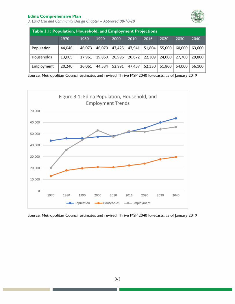
Table 3.1 and Figure 3.1 show past patterns and future projections of growth in Edina by the Metropolitan Council. Population and household growth rates in Edina were relatively steady between 1970 and 2010, though they have increased since then. Employment, after surging in earlier years, has followed a similar pattern. The ratio of jobs to population has remained high, reflecting the role of portions of Edina as a regional employment center. The overall rate of change has increased since 2010, due to many new multifamily residential, commercial, and mixed-use projects.
The forecasts included in this chapter were developed by the Metropolitan Council, indicating the city’s expected share of market-driven growth in the region, should such growth occur. These forecasts are modified versions of those in Edina’s original 2015 System Statement, adjusting for higher-than-expected growth rates in Edina over the past few years. Metropolitan Council forecasts at the local and regional level are adjusted as needed, to reflect new information and market changes. The current forecasts reflect mutual agreement between the Metropolitan Council and Edina regarding implications of market-driven growth trends.
The forecasts are derived from local and regional factors, including past housing and job trends and the city’s expected share of projected regional growth. Between 2020 and 2040, the regional population is expected to increase by 15%, households by 17%, and jobs by 12%. If regional forecasts are realized, Edina’s population is projected to increase by 16% or 8,600, households by 24% or 5,800, and jobs by 8% or 4,300. The faster rates of population and household growth relative to employment reflect the anticipated transition of primarily commercial areas into residential-commercial mixed-use districts. These forecasts are based on several assumptions, including overall economic climate, site availability, and market conditions. The actual counts may be lower or higher than these estimates.
Edina Comprehensive Plan 3. Land Use and Community Design Chapter – Approved 08-18-20
3-3
Table 3.1: Population, Household, and Employment Projections
1970 1980 1990 2000 2010 2016 2020 2030 2040
Population 44,046 46,073 46,070 47,425 47,941 51,804 55,000 60,000 63,600
Households 13,005 17,961 19,860 20,996 20,672 22,309 24,000 27,700 29,800
Employment 20,240 36,061 44,534 52,991 47,457 52,330 51,800 54,000 56,100
Source: Metropolitan Council estimates and revised Thrive MSP 2040 forecasts, as of January 2019
Source: Metropolitan Council estimates and revised Thrive MSP 2040 forecasts, as of January 2019
0
10,000
20,000
30,000
40,000
50,000
60,000
70,000
1970 1980 1990 2000 2010 2016 2020 2030 2040
Figure 3.1: Edina Population, Household, and Employment Trends
Population Households Employment
Edina Comprehensive Plan 3. Land Use and Community Design Chapter – Approved 08-18-20
3-4
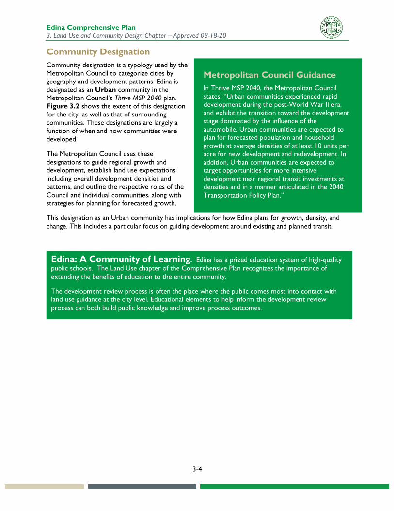
Community Designation Community designation is a typology used by the Metropolitan Council to categorize cities by geography and development patterns. Edina is designated as an Urban community in the Metropolitan Council’s Thrive MSP 2040 plan. Figure 3.2 shows the extent of this designation for the city, as well as that of surrounding communities. These designations are largely a function of when and how communities were developed.
The Metropolitan Council uses these designations to guide regional growth and development, establish land use expectations including overall development densities and patterns, and outline the respective roles of the Council and individual communities, along with strategies for planning for forecasted growth.
This designation as an Urban community has implications for how Edina plans for growth, density, and change. This includes a particular focus on guiding development around existing and planned transit.
Metropolitan Council Guidance In Thrive MSP 2040, the Metropolitan Council states: “Urban communities experienced rapid development during the post-World War II era, and exhibit the transition toward the development stage dominated by the influence of the automobile. Urban communities are expected to plan for forecasted population and household growth at average densities of at least 10 units per acre for new development and redevelopment. In addition, Urban communities are expected to target opportunities for more intensive development near regional transit investments at densities and in a manner articulated in the 2040 Transportation Policy Plan.”
Edina: A Community of Learning. Edina has a prized education system of high-quality public schools. The Land Use chapter of the Comprehensive Plan recognizes the importance of extending the benefits of education to the entire community.
The development review process is often the place where the public comes most into contact with land use guidance at the city level. Educational elements to help inform the development review process can both build public knowledge and improve process outcomes.
Edina Comprehensive Plan 3. Land Use and Community Design Chapter – Approved 08-18-20
3-5
Figure 3.2: Community Designation (Source: Metropolitan Council Thrive MSP 2040)
Edina Comprehensive Plan 3. Land Use and Community Design Chapter – Approved 08-18-20
3-6
Trends and Challenges Strategic redevelopment and reinvestment. Growth of population and jobs helps keep Edina a vibrant, healthy, and attractive place to live and work. However, as a fully developed city, Edina will accommodate growth via the reuse of existing properties. Future development plans must balance market feasibility and responsiveness with overall perceived community benefits. Plans for land use changes should be strategic, particularly in regard to improving access to transportation networks and providing benefits to the community.
Preserving existing residential character. High land prices and scarcity of available land within the city have resulted in a sharp increase in single-family home redevelopment. There has been considerable public discussion about the appropriate massing, height, proportions, and the architectural elements of rebuilt homes in established neighborhoods. Those changes have been reflected in changes in city ordinances since 2010. How the city can balance the desire of some residents for larger homes with state-of-the-art features and developers seeking to offer housing units that appeal to today’s market with the interests of neighbors who object to the size and scale of some new construction is an ongoing concern of the community and the Council.
Adding walkability and bikeability. Much of Edina was developed during post-WWII decades when auto-oriented suburbs did not prioritize accommodating pedestrians and bicycles. A transportation network that allows for additional transit and non-motorized travel options increases the movement capacity of the existing public right-of-way and capitalizes on resident needs for more active lifestyles. Developing a complete non-motorized transportation network will take time and effort and should fit into a well-planned, incremental transportation network.
Changing needs of commercial and industrial uses. The useful life of commercial and industrial buildings tends to be significantly shorter than residential buildings, and many of Edina’s commercial and industrial buildings are aging and potentially obsolete, at least based on their originally intended use. These buildings will need to be renovated, repurposed, or replaced to reflect current and future needs, including creating a much different model for retail than in the past. Increased interest in mixed-use/live-work scenarios also requires evaluation. Vision Edina surveyed respondents on the question of the residential development mix in the city and the need for options to live near where people work. Around 37% expressed a stronger preference for mixed use and diverse residential options, as opposed to a single-family home focus. Around 52% had a stronger preference for “live and work local” options, in contrast to reliance on commuting elsewhere.
Demographic changes. A dominant trend, both locally and nationally, is the overall aging of the population. This has a host of implications for land use, including changes in the type of housing needed, goods and services demanded, and reliance on non-auto transportation options. Additionally, the Vision Edina community engagement process found that both younger (those under 30) and older (those over 60) participants were equally in support of more housing options, in contrast to a single-family housing focus.
Expanding transportation options. In addition to walkability and bikeability at the neighborhood level, there is increased interest in providing access to multiple modes of transportation. This has implications for land use, in terms of locating appropriate housing units and jobs within safe and comfortable walking and bicycling distances of transit stops.
Edina Comprehensive Plan 3. Land Use and Community Design Chapter – Approved 08-18-20
3-7
Existing Land Use and Conditions Overview The existing land uses in the City of Edina provide a view into the character of the community, as well as the starting place for planning future growth and change. A substantial majority of the land area is expected to continue in its current use through 2040, with growth focused in specific defined areas discussed later in the chapter.
This section covers current land use and conditions. This includes the existing land use map and acreages, property value (market value and land/value ratio), building age and condition, and definitions of existing land use categories.
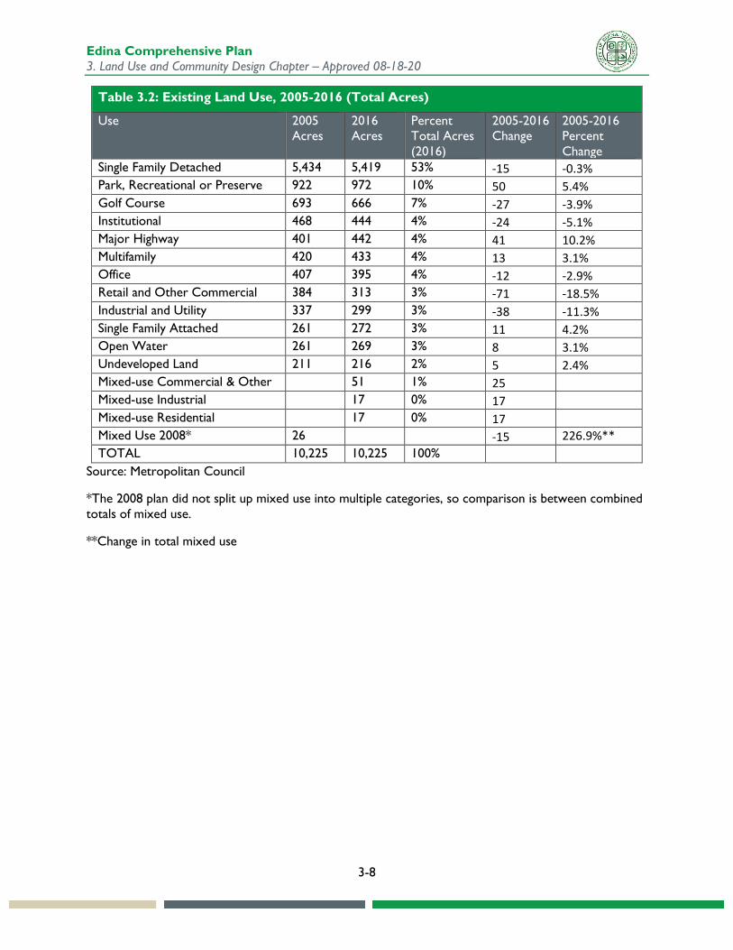
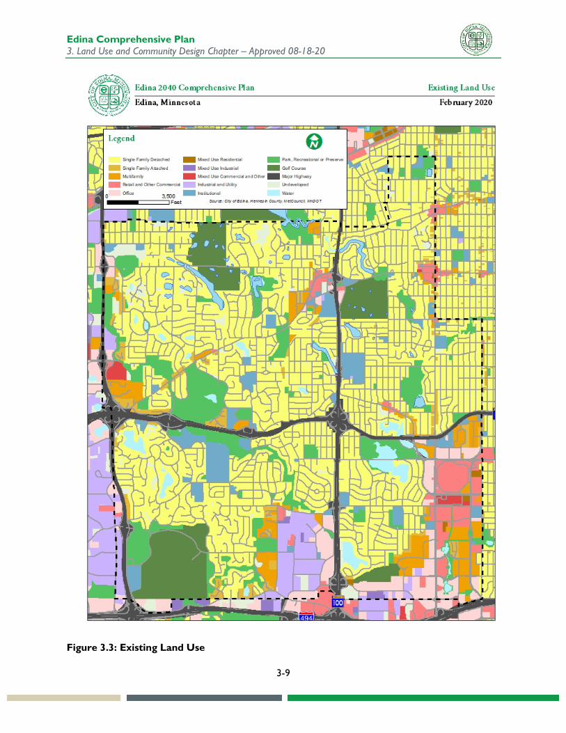
Land Use Map Figure 3.3 shows the existing land uses in the City of Edina, and Table 3.2 shows the percentage of existing land use by category as of 2016, compared with 2005 data from the previous comprehensive plan. Comparing the two years shows a decline in commercial, industrial, and institutional, and a rise in mixed use, parks, and multifamily housing.
Over half of the land in the city (53%) is single family detached residential, with the next largest proportion taken by parks (10%). Golf courses are called out as a separate category, so the percentage of city land in the park system is lower than the stated percentage of open space in the city. Commercial, industrial, and higher density residential uses are clustered in specific areas, typically in defined nodes and districts, as well as along some major corridors. Consistent with the overall regional approach to mapping land use, existing land use calculations in this plan do not distinguish between local roads and adjacent uses. This is different than the parcel-based approach for future land use shown later in the chapter.
Edina Comprehensive Plan 3. Land Use and Community Design Chapter – Approved 08-18-20
3-8
Table 3.2: Existing Land Use, 2005-2016 (Total Acres)
Use 2005 Acres
2016 Acres
Percent Total Acres (2016)
2005-2016 Change
2005-2016 Percent Change
Single Family Detached 5,434 5,419 53% -15 -0.3% Park, Recreational or Preserve 922 972 10% 50 5.4% Golf Course 693 666 7% -27 -3.9% Institutional 468 444 4% -24 -5.1% Major Highway 401 442 4% 41 10.2% Multifamily 420 433 4% 13 3.1% Office 407 395 4% -12 -2.9% Retail and Other Commercial 384 313 3% -71 -18.5% Industrial and Utility 337 299 3% -38 -11.3% Single Family Attached 261 272 3% 11 4.2% Open Water 261 269 3% 8 3.1% Undeveloped Land 211 216 2% 5 2.4% Mixed-use Commercial & Other 51 1% 25 Mixed-use Industrial 17 0% 17 Mixed-use Residential 17 0% 17 Mixed Use 2008* 26 -15 226.9%** TOTAL 10,225 10,225 100%
Source: Metropolitan Council
*The 2008 plan did not split up mixed use into multiple categories, so comparison is between combined totals of mixed use.
**Change in total mixed use
Edina Comprehensive Plan 3. Land Use and Community Design Chapter – Approved 08-18-20
3-9
Figure 3.3: Existing Land Use
Edina Comprehensive Plan 3. Land Use and Community Design Chapter – Approved 08-18-20
3-10
Changes Since 2008 Plan Since the City of Edina is fully developed, changes in existing land use have been incremental based on redevelopment, with a shift towards more multifamily and mixed use within potential areas of change, as shown on Figure 3.11. In the interim since the adoption of the previous comprehensive plan in 2008, there also have been changes to the land use policy and regulatory guidance for the city. These changes include:
• Comprehensive plan amendments to add more detailed guidance for land use density by future land use category.
• Comprehensive plan amendments to provide development guidelines for planned unit development or other larger projects.
• Zoning changes at the individual site level to support new development projects, particularly mixed use.
Existing Land Use Categories Figure 3.3 illustrates the pattern of existing land use in Edina as of 2016. The categories on the map are described as follows:
Single-Family Residential Single-Family Detached. Residential neighborhoods are the most extensive land use within the city in terms of total land area, of which single family detached housing is the largest component. Neighborhood character varies based on era of construction, scale of development, and landscape influences. Although there is significant variation, the most common residential type consists of post-WWII single-family homes on wooded lots along curvilinear streets.
Multifamily Residential Single-Family Attached. This land use consists of residential units with common walls, where each unit has direct exterior access. In Edina the most common buildings of this type are townhouses and duplexes (two-family dwellings). Townhouses tend to be clustered close to highway or major road corridors, while duplexes are often found in narrow strips along major thoroughfares such as Vernon and France Avenues, and serve as a buffer for adjacent single-family neighborhood detached housing.
Multifamily. This land use is defined by the multiple-unit building type where each individual unit does not have direct ground floor access to the exterior. Multifamily developments are concentrated primarily along the main traffic arteries and are generally located toward the edges of the city, often in proximity to retail business establishments. Concentrations of multifamily developments are found along York Avenue, France Avenue, Vernon Avenue, Lincoln Drive, and Cahill Road.
Commercial Retail and Other Commercial. An important part of Edina’s identity is its status as a regional commercial and employment center. The Edina marketplace is dominated by high-end retail, medical, real estate, and banking services, making it a unique destination within the metro area. The city’s demographics, in terms of incomes, match this business market. Retail areas can be defined based on their market positions: regional, community, and neighborhood. Edina’s regional retail district is the Greater Southdale area. Community-level districts include 50th& France and Grandview, although they contain some regional destinations Neighborhood shopping districts, including the commercial nodes at Valley View and Wooddale and West 70th and Cahill, mainly serve surrounding neighborhoods with convenience shopping and services. Several other neighborhoods have small commercial nodes providing convenience goods and services. The larger concentrations of this land use are generally located toward the edges of the city, rather than in the center.
Edina Comprehensive Plan 3. Land Use and Community Design Chapter – Approved 08-18-20
3-11
Office. Long known as a retail center for the southwest metro area, Edina also contains office space in its four business and industrial areas, occupants of which include several large corporations, as covered in the Economic Competitiveness Chapter. This land use is concentrated along such major thoroughfares as the western sides of France Avenue and TH 100 and the northern side of West 66th Street.
Mixed-use Mixed-use Residential. This land use consists of areas with a mix of uses including residential units and commercial. In its 2016 data, the Metropolitan Council recognizes around 17 acres of this land use in the city, primarily in the Southdale area. While a small percentage of overall uses, this has been growing.
Mixed-use Industrial. This land use includes a mixture of industrial uses that may include office and retail but no residential units. The mixed-use industrial land use is found primarily in the Cahill industrial area west of TH 100 and along the south side of West 77th Street in the Pentagon Park area.
Mixed-use Commercial and Other. This land use category contains nonresidential uses exclusively. There are around 51 acres of this designated use in Edina, primarily in the Southdale area and north of Highway 62 on the city’s western border.
Other Land Uses Industrial and Utility. Industrial uses are concentrated near areas with historically lower land prices and multimodal transportation options. Currently, the two areas in the city that meet these qualifications are the Cahill area west of TH 100 and south of West 70th Street, the greater Pentagon Park area, and a smaller concentration along TH 169 as it borders Eden Prairie in the extreme southwest corner of the city. It is expected that lower intensity industrial uses in these areas may cause transition to other types of uses in the future.
Institutional. Institutional land uses are located through the city. They are occupied by large public and private service providers such as public safety (police, fire), essential services (public works), county libraries, hospitals, and other medical care facilities. They also include schools, social, cultural, and educational establishments, and cemeteries.
Parks and Recreation. Edina has an extensive public park system that serves the community and area residents. Parklands include a golf course; biking and walking trails; various forms of recreational and athletic facilities, playgrounds and playing fields; and natural open space. Lands devoted to parks and recreation constitute the second highest percentage of all land use acreages. Some of the land included as park and recreational is within the Minnehaha and Nine Mile Creek floodplains, as well as other floodplains and stormwater drainage areas.
Golf Course. Edina has three major golf courses: Braemar Golf Course – a municipal facility – and the private country clubs of Interlachen Country Club and Edina Country Club. They constitute around 666 acres of the city’s land area.
Major Highway. The city is bisected by two regional arteries, TH 62 and TH 100, trunk highways which divide the city into geographic quadrants. In addition, two more highways, I-494 and TH 169, border the city or pass near its boundaries. These limited access roads allow for convenient access to points outside the city or to destinations within the city for residents, workers, and visitors. The acreage listed for this land use does not include local roads.
Undeveloped. Land categorized as “undeveloped” in the city contains protected and non-protected wetlands, steep slopes, and land not clearly used for any other categorized land use.
Edina Comprehensive Plan 3. Land Use and Community Design Chapter – Approved 08-18-20
3-12
Open Water. Nine Mile and Minnehaha Creeks provide a natural drainage system for the city’s land. Numerous lakes are both independent and linked to the creeks.
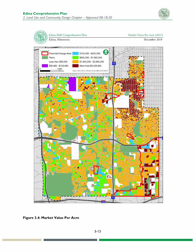
Property Value Assessed property value is an important determinant of how market forces, property condition, and community context contribute to the perceived value of a property. This section is included to provide an overview of current conditions in Edina, as well as some implications.
Figure 3.4 shows estimated market value per acre. Property values in Edina tend to be among the highest in the region, reflecting the desirable nature of the community. In Edina, the area with the most consistently high values per acre is the Country Club District, a designated historic district on the National Register of Historic Places. (See Chapter 13 Heritage Preservation for more information on designated historic resources.) Property values are more variable (though still fairly high) in the western neighborhoods. While high values may mean that property owners are able to keep their investments, they may also make it more challenging to maintain affordability.
High land values in particular may make certain areas more attractive for redevelopment, particularly when the building value is relatively low in comparison. For areas where the value of the land is fairly high relative to the building value, it may be attractive to either renovate or expand the building, or to redevelop the site entirely. This is not always allowed under ordinance or encouraged by policy, although either may be modified by the City Council in response to changing conditions or opportunities. An example of this situation could be a location where land values may make it economically feasible to develop at a scale beyond what is allowed under city policy and regulation.
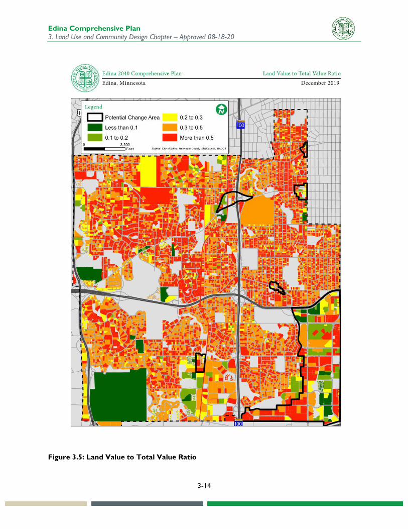
Figure 3.5 shows the ratio of land value to total value for a property. A substantial amount of the land in Edina has land values that are more than half of the total value. This suggests that the underlying property is a very strong contributor to the value – which is consistent with much of what is known about Edina from other sources. In such circumstances, there may be market incentive to further invest in the property through expansion or redevelopment.
These figures show potential change areas, which are guided for growth and redevelopment in accordance with small area plans and covered later in the chapter. Properties within these change areas with relatively high land-to-value ratios may be targets for redevelopment. One example of a potential change area, based on these maps, could be the Cahill industrial area.
Edina Comprehensive Plan 3. Land Use and Community Design Chapter – Approved 08-18-20
3-13
Figure 3.4: Market Value Per Acre
Edina Comprehensive Plan 3. Land Use and Community Design Chapter – Approved 08-18-20
3-14
Figure 3.5: Land Value to Total Value Ratio
Edina Comprehensive Plan 3. Land Use and Community Design Chapter – Approved 08-18-20
3-15
Building Age and Condition Building age and condition are contributing factors when determining future redevelopment potential. All other things being equal, older and poorer condition buildings may be more viable redevelopment opportunities than those that are newer and better condition. There are exceptions to this, particularly in the case of protected historic properties. Additionally, there may be opportunities to reinvest in the property, rather than to change use or scale.
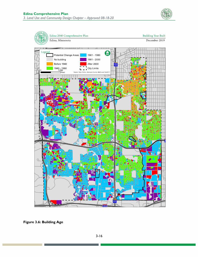
Figure 3.6 shows the age of the buildings in Edina. Starting as a largely rural farm community on the outskirts of the Twin Cities region in the early 1900’s, Edina evolved rapidly into a developing suburb, with its own commercial and employment centers. Growth spread outwards from the area closest to Minneapolis, with the full extent of the existing city limits mostly developed by the 1980’s. Land use patterns reflect planned growth areas, largely separated by use and intensity, though there have been more mixed-uses in recent years.
It’s notable that there is also a sprinkling of newer housing in some of the oldest neighborhoods. This reflects new construction, either on infill sites or replacement of existing housing stock. Building permit data shows this has continued in recent years at a moderate pace.
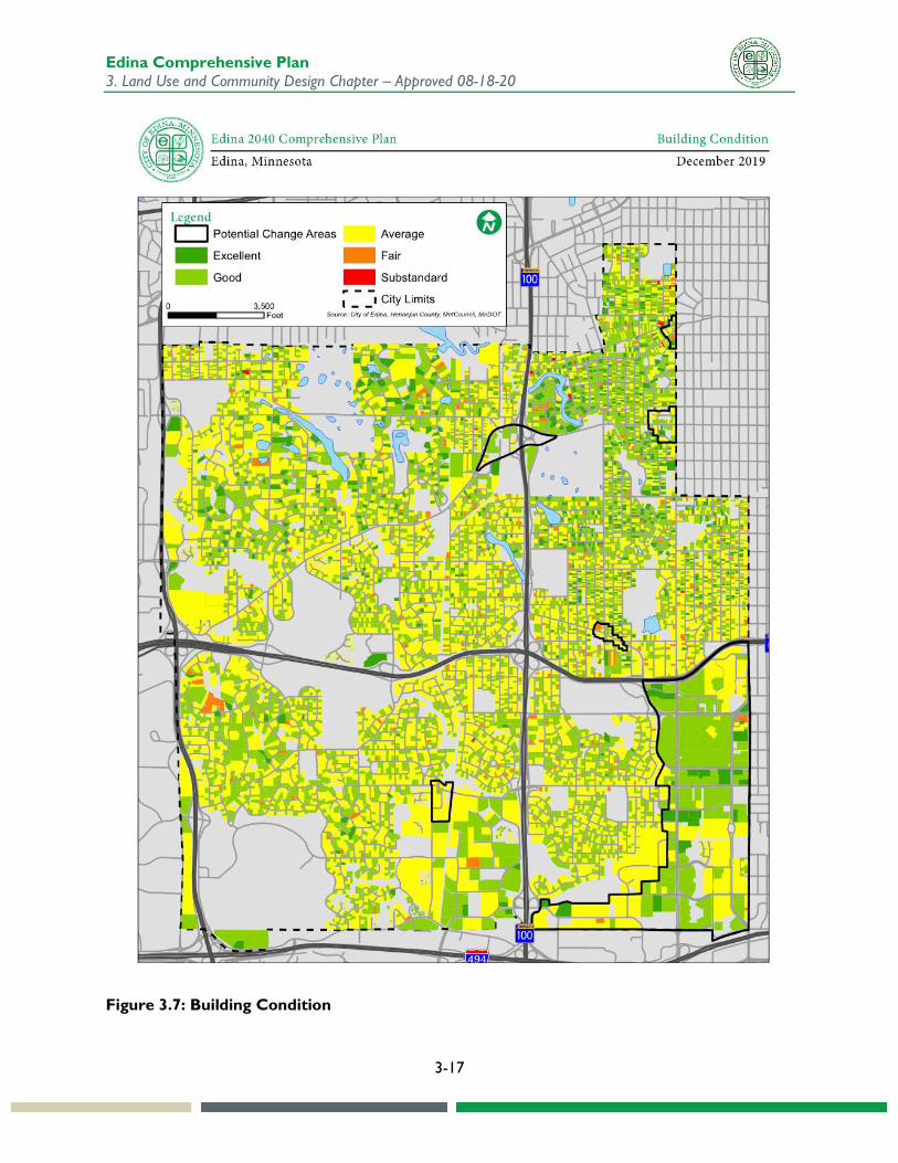
Figure 3.7 shows the condition of buildings in Edina. This is collected on a multi-year cycle by the City of Edina. Since not every building is surveyed every year, it may not be completely up-to-date for any given structure. Since it is based primarily on an external assessment of building appearance, it may not reflect the condition of interiors or building systems. Due to these limitations, additional investigation may be needed at the individual property level to more completely assess a building’s condition.
For the most part, buildings in the city are in average-to-good condition, with just a few scattered exceptions. As with other patterns, the oldest and most historic areas stand out as exceptional. However, there are many well-maintained properties throughout the city.
Edina Comprehensive Plan 3. Land Use and Community Design Chapter – Approved 08-18-20
3-16
Figure 3.6: Building Age
Edina Comprehensive Plan 3. Land Use and Community Design Chapter – Approved 08-18-20
3-17
Figure 3.7: Building Condition
Edina Comprehensive Plan 3. Land Use and Community Design Chapter – Approved 08-18-20
3-18
Residential Density Since Edina is a fully developed community with no room to expand its boundaries, increased residential density may be needed to accommodate potential new growth within the city. Areas with concentrations of residential density are beneficial in various other ways, such as:
• providing a customer and workforce base for commercial districts • supporting the viability of alternative transportation modes such as transit, car share, micro
transit, and nonmotorized • generating activity and interactions that support community placemaking • more efficiently using existing infrastructure and public service capacity • protecting undeveloped areas in the region from encroaching outward on development • creating additional tax base to take some of the tax burden off single family housing.
Denser areas may also generate higher traffic volumes, increase demands for public services, and create environmental consequences. One purpose of this plan is to anticipate those effects, and to plan for improvements and investments that reduce or mitigate such impacts. Potential impacts addressed in the comprehensive plan include, but are not limited to:
• Multimodal transportation needs (Transportation Chapter) • Water supply, sanitary sewer, and stormwater system needs (Water Resources Chapter) • Parks and trails (Parks, Open Space, and Natural Resources Chapter) • Environmental impacts (Energy and Environment Chapter) • Community service and facility needs (Community Services and Facilities Chapter) • Economic development opportunities (Economic Competitiveness Chapter)
Residential density in Edina is measured and regulated in terms of total dwelling units per acre, consistent with regional standards. What a building of a certain density will look like is not always intuitive. Due to variations in unit size, building layout, and site design, two buildings with the same number of units per acre can appear very different from one another in terms of height, bulk, and character. While it is useful to allocate growth in terms of the number of units that can be placed on a site, units per acre should not be the only measure used to determine whether a certain development is appropriate for a site or a neighborhood. Additionally, variations in unit size impact units per acre calculations. An example could be small units for senior housing or micro units that increase the number of dwelling units per acre.
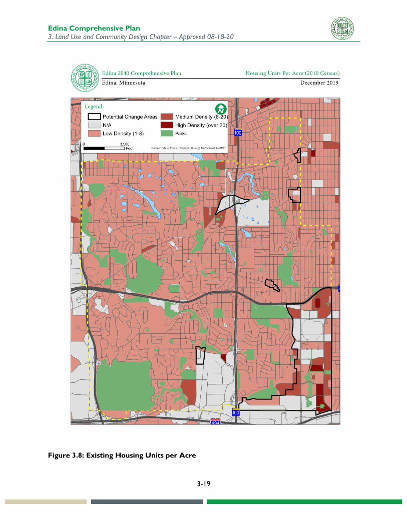
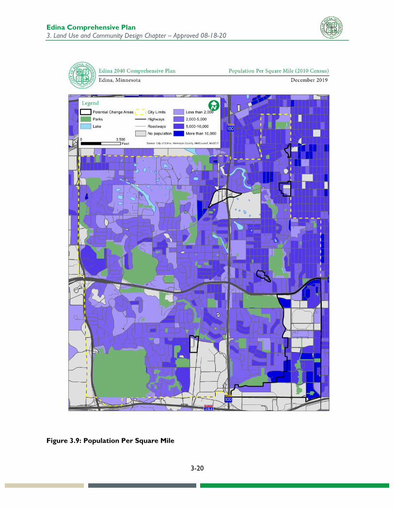
Figure 3.8 shows the distribution of housing unit density across the city, and Figure 3.9 shows population density. Since this was based on 2010 data, it does not show development that has been constructed and occupied since 2010. Housing and population densities follow similar patterns to overall land uses. Almost all the single-family areas of Edina average less than five units per gross acre, with higher densities in multifamily and mixed-use areas. The older neighborhoods along the eastern side of Edina are slightly higher density than other single-family neighborhoods, reflecting smaller lots and smaller buildings.
Edina Comprehensive Plan 3. Land Use and Community Design Chapter – Approved 08-18-20
3-19
Figure 3.8: Existing Housing Units per Acre
Edina Comprehensive Plan 3. Land Use and Community Design Chapter – Approved 08-18-20
3-20
Figure 3.9: Population Per Square Mile

Edina Comprehensive Plan 3. Land Use and Community Design Chapter – Approved 08-18-20
3-21
Table 3.3 summarizes Edina’s residential acreage by existing land use category. Single family detached housing covers the majority of residential acres in the city.
Table 3.3: Residential Acres by Type (Total Acres)
Land Use Acres Percent of Total
Single Family Detached 5,419 88.2% Single Family Attached 272 4.4% Multifamily 433 7.1% Mixed-use Residential 17 0.3% Total 6,141 100%
Source: Metropolitan Council
Net residential density is used to determine how dense residential areas are within a community. For the purposes of utility planning, this is an indicator of whether a development pattern is compact enough to be efficiently served. For the purposes of transportation planning, it is an indicator of where development is dense enough to support alternative travel modes such as transit.
Net residential density is determined by subtracting from total acres the undevelopable portions of residential land, including wetlands and water bodies, public parks and open space, major road right-of-way, and other areas protected from development by local ordinances. Since Edina is a fully developed community, undevelopable acres account for a fairly small percentage of residential parcels, since most of those areas have either been modified or converted to permanent open space. Table 3.4 shows net residential density in Edina.
Table 3.4: Net Residential Density in 2016
Land Use Number of Units
Acres Gross Residential
Acres Undevelopable
Net Residential Acres
Net Density Units/Acre
Single Family Attached
12,851 5,419 329 5,090 2.5
Single Family Detached
1,326 272 15 257 5.2
Multifamily 8,980 433 20 413 21.8 Mixed-use Residential
353 17 0 17 20.8
Total 23,510 6,141 364 5,777 4.1 Source: Metropolitan Council

Edina Comprehensive Plan 3. Land Use and Community Design Chapter – Approved 08-18-20
3-22
Potential Change Areas The Comprehensive Plan functions as a long-range tool that anticipates where growth in populations, households, and jobs will be incorporated in the city.
As a fully developed city, it is expected that most of the land in Edina will maintain its current land use, scale, and intensity. Where there are single-family home neighborhoods, they will remain single family home neighborhoods. Greater density may occur in areas other than single-family neighborhoods. Appropriate transitions will need to continue to be implemented for development in areas that abut neighborhoods with single-family homes.
No area of the city is expected to be completely static. Due to the city’s aging building stock and changing needs of residents and businesses, continued investments will be required for rehabilitation, expansion, and replacement of existing structures. The numbers of residents in single-family neighborhoods and employees in commercial locations are expected to remain approximately the same.
There are areas of the city that have some capacity to accommodate new growth in the form of housing units and job-generating uses. These are places where infrastructure capacity to support new growth is already relatively robust. The Greater Southdale District is the largest of these potential areas and will be expected to accommodate a sizeable percentage of citywide growth if that growth becomes reality.
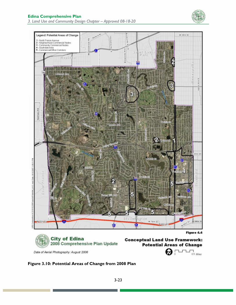
The City of Edina 2008 comprehensive plan identified “potential areas of change” as shown on Figure 3.10. These were places where change was most likely to occur. A major recommendation following up on this designation was to complete small area plans for “specific neighborhoods, districts, or potential areas of change in the community” to provide more specific guidance for these areas.
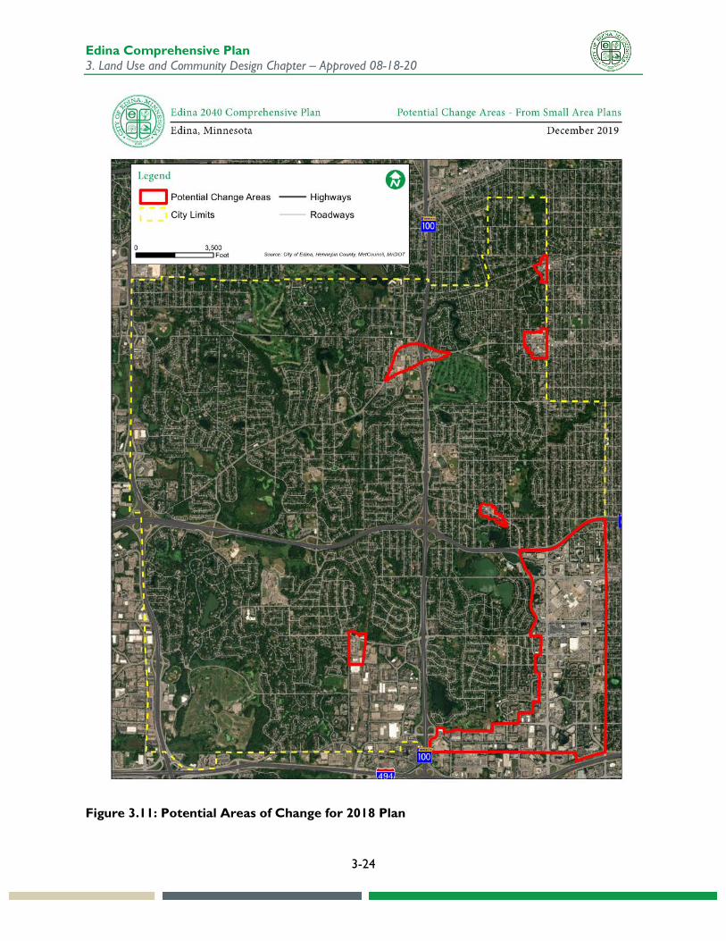
Working with community-based stakeholder groups and through extensive public engagement, the City has undertaken and completed plans for the following areas. The study areas are shown on Figure 3.11, with the boundaries that were established for those respective plans.
• GrandView Development Framework (2012) • Small Area Plan for the Wooddale-Valley View Neighborhood Node (2015) • Greater Southdale District Plan (2018) • Small Area Plan for the City of Edina’s 44th & France Neighborhood Node (2018) • Small Area Plan for the City of Edina’s 70th & Cahill Neighborhood Node (2018) • Small Area Plan for the City of Edina’s 50th & France District (2019)
These City Council adopted small area plans are incorporated into the comprehensive plan by reference. Recommendations from the plans for land use guidance and other elements has been incorporated onto the future land use map and throughout the comprehensive plan. The Edina Big Ideas process identified three potential small areas for future consideration, including Lincoln/169/Eden Prairie, expanded 70th & Cahill, and Pentagon Park. The 2008 plan also showed a portion of North France Avenue, which may be potentially impacted by the future E Line Rapid Bus project. The City will continue to monitor these areas for growth potential. There may also be additional studies in the future.
Edina Comprehensive Plan 3. Land Use and Community Design Chapter – Approved 08-18-20
3-23
Figure 3.10: Potential Areas of Change from 2008 Plan
Edina Comprehensive Plan 3. Land Use and Community Design Chapter – Approved 08-18-20
3-24
Figure 3.11: Potential Areas of Change for 2018 Plan
Edina Comprehensive Plan 3. Land Use and Community Design Chapter – Approved 08-18-20
3-25
Future Land Use Land Use Plan The future land use plan is the guide for the allowed type and intensity of development citywide. It does not provide the full level of detail shown in the zoning code – rather, it is overarching guidance for the patterns, to ensure decisions made through the city’s regulatory and enforcement process are consistent with a comprehensive approach and strategy.
As a developed community, the future land use plan does not change dramatically from year to year. The boundaries of Edina are not expected to be altered and many of the overall patterns have been established for decades. Despite this, the city has capacity to accommodate growth and change through the redevelopment and renewal of sites in targeted areas.
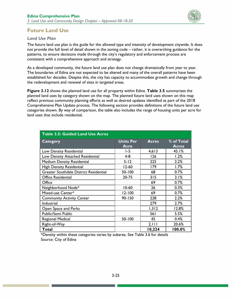
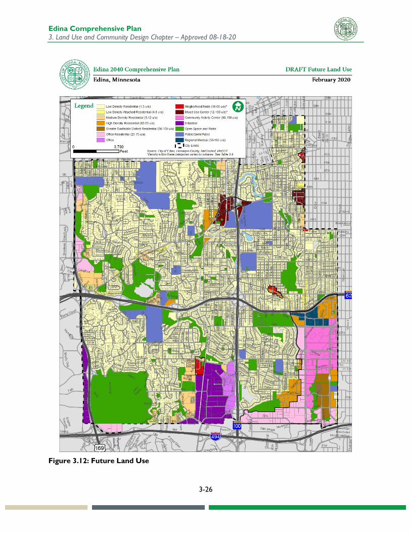
Figure 3.12 shows the planned land use for all property within Edina. Table 3.5 summarizes the planned land uses by category shown on the map. The planned future land uses shown on this map reflect previous community planning efforts as well as desired updates identified as part of the 2018 Comprehensive Plan Update process. The following section provides definitions of the future land use categories shown. By way of comparison, the table also includes the range of housing units per acre for land uses that include residential.
Table 3.5: Guided Land Use Acres
Category Units Per Acre
Acres % of Total Acres
Low Density Residential 1-5 4,613 45.1% Low Density Attached Residential 4-8 126 1.2% Medium Density Residential 5-12 225 2.2% High Density Residential 12-60 179 1.7% Greater Southdale District Residential 50-100 68 0.7% Office Residential 20-75 315 3.1% Office 69 0.7% Neighborhood Node* 10-60 26 0.3% Mixed-use Center* 12-100 69 0.7% Community Activity Center 90-150 228 2.2% Industrial 279 2.7% Open Space and Parks 1,312 12.8% Public/Semi Public 561 5.5% Regional Medical 50-100 45 0.4% Right-of-Way 2,111 20.6% Total 10,224 100.0%
*Density within these categories varies by subarea. See Table 3.6 for details Source: City of Edina
Edina Comprehensive Plan 3. Land Use and Community Design Chapter – Approved 08-18-20
3-26
Figure 3.12: Future Land Use
Edina Comprehensive Plan 3. Land Use and Community Design Chapter – Approved 08-18-20
3-27
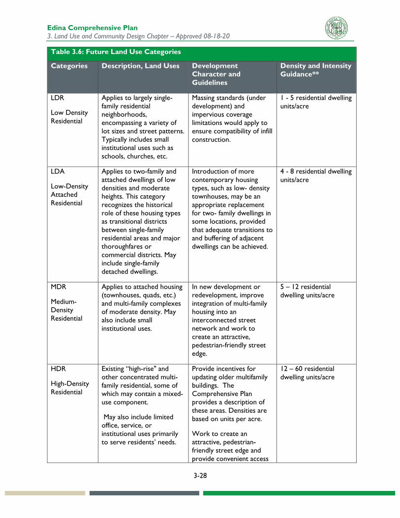
Future Land Use Categories The categories in Table 3.6 apply to the Future Land Use Plan. Land use categories are broader and more long-term in scope than zoning districts. The land use plan and the zoning ordinance should be consistent with one another but not necessarily identical. Each land use category may be implemented through more than one zoning district, allowing for differences in building height, bulk and coverage in different areas of the city. Some revisions to existing zoning districts or creation of new districts may be needed as part of the implementation of the land use plan.
Land in cities is categorized first by how it is used, and secondarily by the scale and intensity of that use. For residential uses, density is defined in terms of dwelling units per net acre (exclusive of major road rights-of-way and public lands). For nonresidential and mixed-uses, intensity is typically defined in terms of floor-to-area ratio, or FAR, which refers to the ratio of a building’s total floor area to the size of its lot. Thus, a maximum FAR of 1.0 could allow for a two-story building covering 50% of the lot, a three-story building on one-third of the lot, and so on. FAR limits for uses are regulated through the City’s zoning code. Building heights are not specified in the table because height will vary within and between categories, based on neighborhood context, infrastructure, and community design goals. The small area plans incorporated by reference here provide more detailed information on height and density guidance.
The “Development Guidelines" in the table below are intended to highlight important design considerations for each land use category but are not regulatory in nature. The maximum densities given may not be achievable on all development sites, and other factors besides comprehensive plan guidelines are used to determine the appropriate scale and density of development on a site.
The density ranges shown in this plan are consistent with those developed in the small area planning process for the designated areas of change. They are also consistent with Metropolitan Council standards for existing and planned transit service levels, and Edina’s classification as an Urban community.
While the system statement prepared for Edina by the Metropolitan Council identifies Edina as being within the area of influence for the Minneapolis Saint Paul International Airport (MSP). As it is within the six nautical mile radius, this includes limitations on new landfills and wind towers, neither of which are planned for Edina. See Appendix A for a map of airport influence areas and Chapter 5 Transportation for more information on aviation.
The Metropolitan Council requires that Edina address aggregate resources in its comprehensive plan. Appendix A includes a map that shows aggregate resources superimposed over future land use patterns. Although the regional Aggregate Resources Inventory shows some former gravel mining operations within city limits, all of these have been discontinued, and the sites have been subsequently urbanized. There is no plan to do any further mining within Edina, so there are no potential land use conflicts.
For more information on protection of special and natural resources, see Chapter 6 Parks, Chapter 8 Energy and Environment, and Chapter 13 Heritage Preservation.
Edina Comprehensive Plan 3. Land Use and Community Design Chapter – Approved 08-18-20
3-28
Table 3.6: Future Land Use Categories
Categories Description, Land Uses Development Character and Guidelines
Density and Intensity Guidance**
LDR
Low Density Residential
Applies to largely single-family residential neighborhoods, encompassing a variety of lot sizes and street patterns. Typically includes small institutional uses such as schools, churches, etc.
Massing standards (under development) and impervious coverage limitations would apply to ensure compatibility of infill construction.
1 - 5 residential dwelling units/acre
LDA
Low-Density Attached Residential
Applies to two-family and attached dwellings of low densities and moderate heights. This category recognizes the historical role of these housing types as transitional districts between single-family residential areas and major thoroughfares or commercial districts. May include single-family detached dwellings.
Introduction of more contemporary housing types, such as low- density townhouses, may be an appropriate replacement for two- family dwellings in some locations, provided that adequate transitions to and buffering of adjacent dwellings can be achieved.
4 - 8 residential dwelling units/acre
MDR
Medium-Density Residential
Applies to attached housing (townhouses, quads, etc.) and multi-family complexes of moderate density. May also include small institutional uses.
In new development or redevelopment, improve integration of multi-family housing into an interconnected street network and work to create an attractive, pedestrian-friendly street edge.
5 – 12 residential dwelling units/acre
HDR
High-Density Residential
Existing “high-rise" and other concentrated multi-family residential, some of which may contain a mixed-use component.
May also include limited office, service, or institutional uses primarily to serve residents’ needs.
Provide incentives for updating older multifamily buildings. The Comprehensive Plan provides a description of these areas. Densities are based on units per acre.
Work to create an attractive, pedestrian-friendly street edge and provide convenient access
12 – 60 residential dwelling units/acre
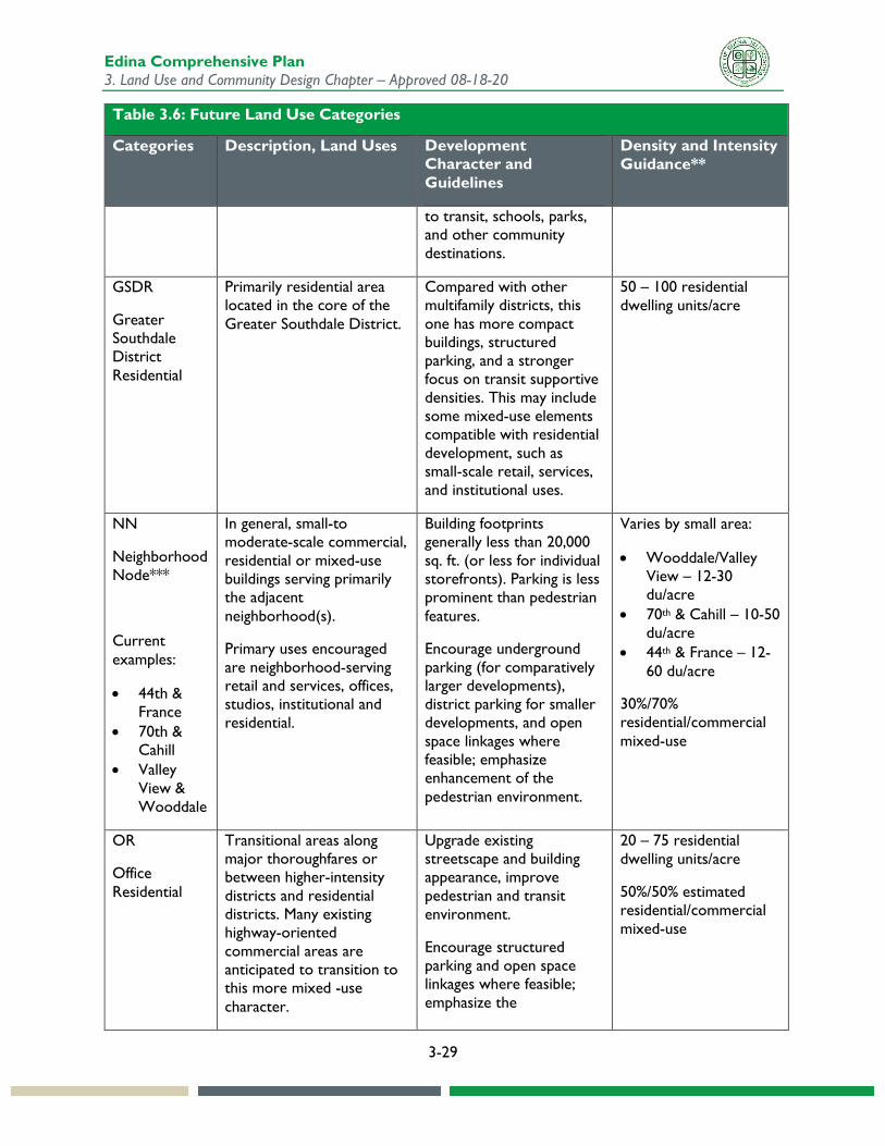
Edina Comprehensive Plan 3. Land Use and Community Design Chapter – Approved 08-18-20
3-29
Table 3.6: Future Land Use Categories
Categories Description, Land Uses Development Character and Guidelines
Density and Intensity Guidance**
to transit, schools, parks, and other community destinations.
GSDR
Greater Southdale District Residential
Primarily residential area located in the core of the Greater Southdale District.
Compared with other multifamily districts, this one has more compact buildings, structured parking, and a stronger focus on transit supportive densities. This may include some mixed-use elements compatible with residential development, such as small-scale retail, services, and institutional uses.
50 – 100 residential dwelling units/acre
NN
Neighborhood Node***
Current examples:
• 44th & France
• 70th & Cahill
• Valley View & Wooddale
In general, small-to moderate-scale commercial, residential or mixed-use buildings serving primarily the adjacent neighborhood(s).
Primary uses encouraged are neighborhood-serving retail and services, offices, studios, institutional and residential.
Building footprints generally less than 20,000 sq. ft. (or less for individual storefronts). Parking is less prominent than pedestrian features.
Encourage underground parking (for comparatively larger developments), district parking for smaller developments, and open space linkages where feasible; emphasize enhancement of the pedestrian environment.
Varies by small area:
• Wooddale/Valley View – 12-30 du/acre
• 70th & Cahill – 10-50 du/acre
• 44th & France – 12-60 du/acre
30%/70% residential/commercial mixed-use
OR
Office Residential
Transitional areas along major thoroughfares or between higher-intensity districts and residential districts. Many existing highway-oriented commercial areas are anticipated to transition to this more mixed -use character.
Upgrade existing streetscape and building appearance, improve pedestrian and transit environment.
Encourage structured parking and open space linkages where feasible; emphasize the
20 – 75 residential dwelling units/acre
50%/50% estimated residential/commercial mixed-use
Edina Comprehensive Plan 3. Land Use and Community Design Chapter – Approved 08-18-20
3-30
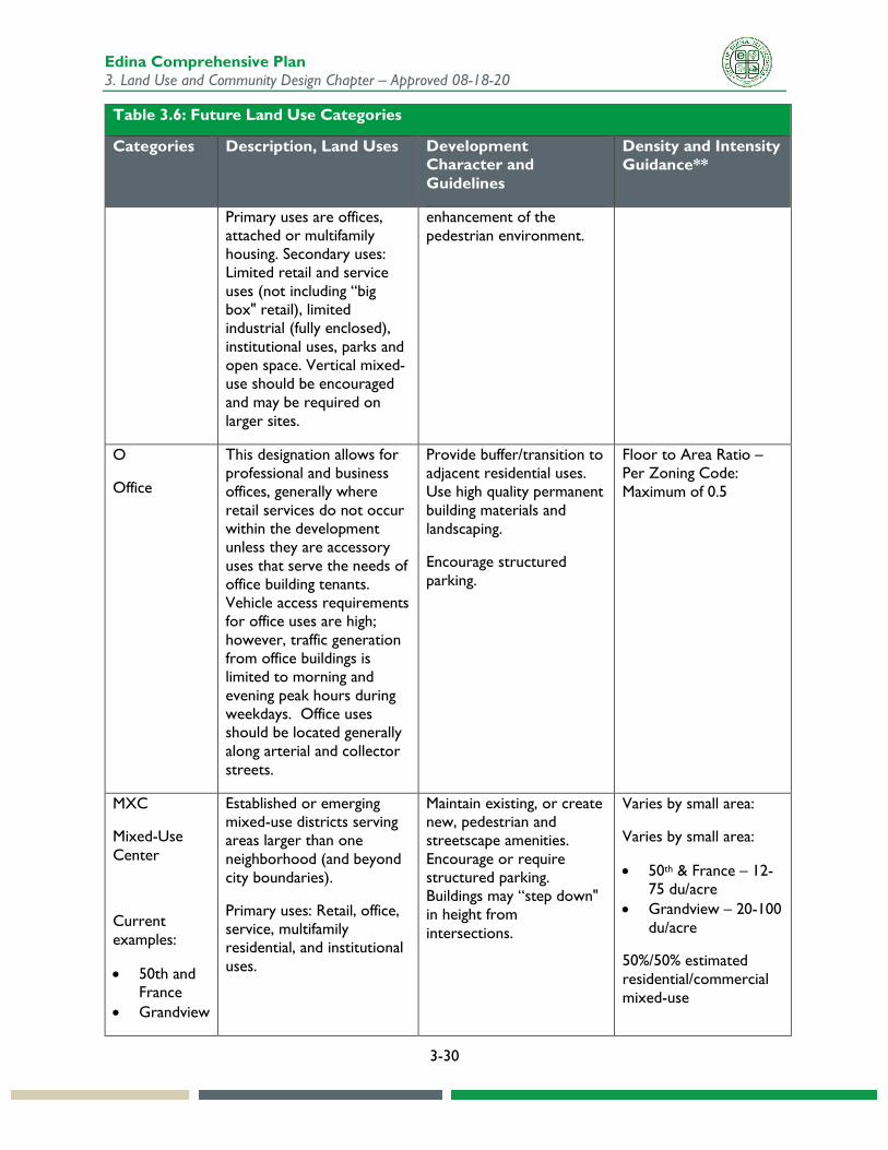
Table 3.6: Future Land Use Categories
Categories Description, Land Uses Development Character and Guidelines
Density and Intensity Guidance**
Primary uses are offices, attached or multifamily housing. Secondary uses: Limited retail and service uses (not including “big box" retail), limited industrial (fully enclosed), institutional uses, parks and open space. Vertical mixed-use should be encouraged and may be required on larger sites.
enhancement of the pedestrian environment.
O
Office
This designation allows for professional and business offices, generally where retail services do not occur within the development unless they are accessory uses that serve the needs of office building tenants. Vehicle access requirements for office uses are high; however, traffic generation from office buildings is limited to morning and evening peak hours during weekdays. Office uses should be located generally along arterial and collector streets.
Provide buffer/transition to adjacent residential uses. Use high quality permanent building materials and landscaping.
Encourage structured parking.
Floor to Area Ratio – Per Zoning Code: Maximum of 0.5
MXC
Mixed-Use Center
Current examples:
• 50th and France
• Grandview
Established or emerging mixed-use districts serving areas larger than one neighborhood (and beyond city boundaries).
Primary uses: Retail, office, service, multifamily residential, and institutional uses.
Maintain existing, or create new, pedestrian and streetscape amenities. Encourage or require structured parking. Buildings may “step down" in height from intersections.
Varies by small area:
Varies by small area:
• 50th & France – 12-75 du/acre
• Grandview – 20-100 du/acre
50%/50% estimated residential/commercial mixed-use
Edina Comprehensive Plan 3. Land Use and Community Design Chapter – Approved 08-18-20
3-31
Table 3.6: Future Land Use Categories
Categories Description, Land Uses Development Character and Guidelines
Density and Intensity Guidance**
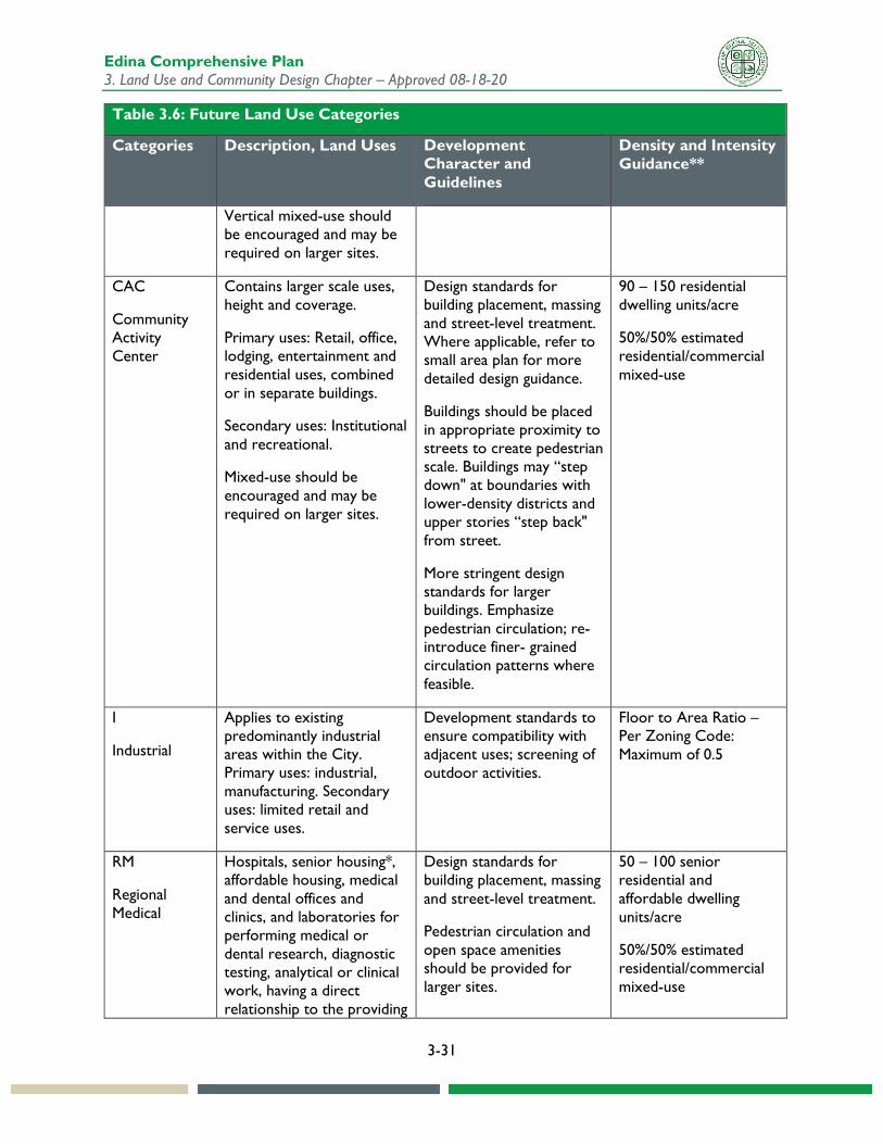
Vertical mixed-use should be encouraged and may be required on larger sites.
CAC
Community Activity Center
Contains larger scale uses, height and coverage.
Primary uses: Retail, office, lodging, entertainment and residential uses, combined or in separate buildings.
Secondary uses: Institutional and recreational.
Mixed-use should be encouraged and may be required on larger sites.
Design standards for building placement, massing and street-level treatment. Where applicable, refer to small area plan for more detailed design guidance.
Buildings should be placed in appropriate proximity to streets to create pedestrian scale. Buildings may “step down" at boundaries with lower-density districts and upper stories “step back" from street.
More stringent design standards for larger buildings. Emphasize pedestrian circulation; re-introduce finer- grained circulation patterns where feasible.
90 – 150 residential dwelling units/acre
50%/50% estimated residential/commercial mixed-use
I
Industrial
Applies to existing predominantly industrial areas within the City. Primary uses: industrial, manufacturing. Secondary uses: limited retail and service uses.
Development standards to ensure compatibility with adjacent uses; screening of outdoor activities.
Floor to Area Ratio – Per Zoning Code: Maximum of 0.5
RM
Regional Medical
Hospitals, senior housing*, affordable housing, medical and dental offices and clinics, and laboratories for performing medical or dental research, diagnostic testing, analytical or clinical work, having a direct relationship to the providing
Design standards for building placement, massing and street-level treatment.
Pedestrian circulation and open space amenities should be provided for larger sites.
50 – 100 senior residential and affordable dwelling units/acre
50%/50% estimated residential/commercial mixed-use
Edina Comprehensive Plan 3. Land Use and Community Design Chapter – Approved 08-18-20
3-32
Table 3.6: Future Land Use Categories
Categories Description, Land Uses Development Character and Guidelines
Density and Intensity Guidance**
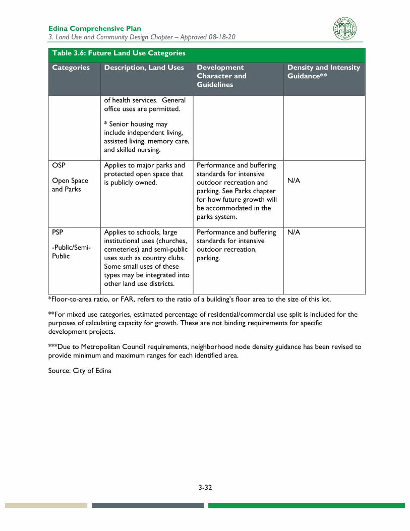
of health services. General office uses are permitted.
* Senior housing may include independent living, assisted living, memory care, and skilled nursing.
OSP
Open Space and Parks
Applies to major parks and protected open space that is publicly owned.
Performance and buffering standards for intensive outdoor recreation and parking. See Parks chapter for how future growth will be accommodated in the parks system.
N/A
PSP
-Public/Semi-Public
Applies to schools, large institutional uses (churches, cemeteries) and semi-public uses such as country clubs. Some small uses of these types may be integrated into other land use districts.
Performance and buffering standards for intensive outdoor recreation, parking.
N/A
*Floor-to-area ratio, or FAR, refers to the ratio of a building’s floor area to the size of this lot.
**For mixed use categories, estimated percentage of residential/commercial use split is included for the purposes of calculating capacity for growth. These are not binding requirements for specific development projects.
***Due to Metropolitan Council requirements, neighborhood node density guidance has been revised to provide minimum and maximum ranges for each identified area.
Source: City of Edina
Edina Comprehensive Plan 3. Land Use and Community Design Chapter – Approved 08-18-20
3-33
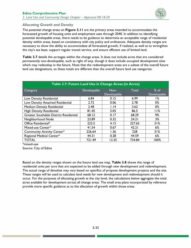
Allocating Growth and Density The potential change areas on Figure 3.11 are the primary areas intended to accommodate the forecasted growth of housing units and employment uses through 2040. In addition to identifying potential developable areas, there needs to be guidance to determine an acceptable range of residential density within areas, based on consistency with city policy and ordinances. Adequate density ranges are necessary to show the ability to accommodate all forecasted growth, if realized, as well as to strengthen the city’s tax base, support regular transit service, and ensure efficient use of limited land.
Table 3.7 details the acreages within the change areas. It does not include acres that are considered permanently non-developable, such as right of way, though it does include occupied development sites which may redevelop in the future. Note that the redevelopment areas are a subset of the overall future land use designations, so these totals are different than the overall future land use categories.
Table 3.7: Future Land Use in Change Areas (in Acres)
Category Developable Non-Developable
Total % of Developable
Low Density Residential 6.84 0.15 6.99 1% Low Density Attached Residential 2.72 0.06 2.78 0% Medium Density Residential 2.48 1.14 3.62 0% High Density Residential 81.45 5.05 86.5 11% Greater Southdale District Residential 68.12 0.17 68.29 9% Neighborhood Node 23.89 0.32 24.21 3% Office Residential* 223.5 4.15 227.65 31% Mixed-use Center* 41.54 0.67 42.21 6% Community Activity Center* 226.64 1.36 228 31% Regional Medical Center* 44.31 0.28 44.59 6% TOTAL 721.49 13.35 734.84 100%
*mixed-use Source: City of Edina
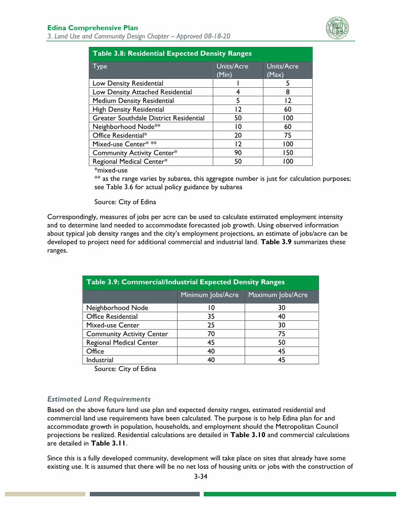
Based on the density ranges shown on the future land use map, Table 3.8 shows the range of residential units per acre that are expected to be added through new development and redevelopment. The actual range of densities may vary based on specifics of propose development projects and the site. These ranges will be used to calculate land needs for new development and redevelopment should it occur. For the purposes of allocating growth at the city level, the calculations below aggregate the total acres available for development across all change areas. The small area plans incorporated by reference provide more specific guidance as to the allocation of growth within those areas.
Edina Comprehensive Plan 3. Land Use and Community Design Chapter – Approved 08-18-20
3-34
Table 3.8: Residential Expected Density Ranges
Type Units/Acre (Min)
Units/Acre (Max)
Low Density Residential 1 5 Low Density Attached Residential 4 8 Medium Density Residential 5 12 High Density Residential 12 60 Greater Southdale District Residential 50 100 Neighborhood Node** 10 60 Office Residential* 20 75 Mixed-use Center* ** 12 100 Community Activity Center* 90 150 Regional Medical Center* 50 100 *mixed-use ** as the range varies by subarea, this aggregate number is just for calculation purposes; see Table 3.6 for actual policy guidance by subarea
Source: City of Edina
Correspondingly, measures of jobs per acre can be used to calculate estimated employment intensity and to determine land needed to accommodate forecasted job growth. Using observed information about typical job density ranges and the city’s employment projections, an estimate of jobs/acre can be developed to project need for additional commercial and industrial land. Table 3.9 summarizes these ranges.
Table 3.9: Commercial/Industrial Expected Density Ranges
Minimum Jobs/Acre Maximum Jobs/Acre
Neighborhood Node 10 30 Office Residential 35 40 Mixed-use Center 25 30 Community Activity Center 70 75 Regional Medical Center 45 50 Office 40 45 Industrial 40 45
Source: City of Edina
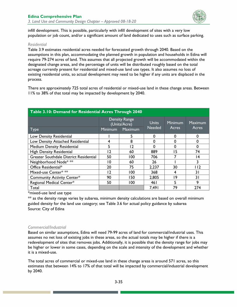
Estimated Land Requirements Based on the above future land use plan and expected density ranges, estimated residential and commercial land use requirements have been calculated. The purpose is to help Edina plan for and accommodate growth in population, households, and employment should the Metropolitan Council projections be realized. Residential calculations are detailed in Table 3.10 and commercial calculations are detailed in Table 3.11.
Since this is a fully developed community, development will take place on sites that already have some existing use. It is assumed that there will be no net loss of housing units or jobs with the construction of
Edina Comprehensive Plan 3. Land Use and Community Design Chapter – Approved 08-18-20
3-35
infill development. This is possible, particularly with infill development of sites with a very low population or job count, and/or a significant amount of land dedicated to uses such as surface parking.
Residential Table 3.9 estimates residential acres needed for forecasted growth through 2040. Based on the assumptions in this plan, accommodating the planned growth in population and households in Edina will require 79-274 acres of land. This assumes that all projected growth will be accommodated within the designated change areas, and the percentage of units will be distributed roughly based on the total acreage currently present for residential and mixed-use land use types. It also assumes no loss of existing residential units, so actual development may need to be higher if any units are displaced in the process.
There are approximately 725 total acres of residential or mixed-use land in these change areas. Between 11% to 38% of that total may be impacted by development by 2040.
Table 3.10: Demand for Residential Acres Through 2040
Density Range (Units/Acre) Units
Needed Minimum
Acres Maximum
Acres Type Minimum Maximum
Low Density Residential 1 5 0 0 0 Low Density Attached Residential 4 8 0 0 0 Medium Density Residential 5 12 0 0 0 High Density Residential 12 60 889 15 74 Greater Southdale District Residential 50 100 706 7 14 Neighborhood Node* ** 10 60 26 1 3 Office Residential* 20 75 2,237 30 112 Mixed-use Center* ** 12 100 368 4 31 Community Activity Center* 90 150 2,805 19 31 Regional Medical Center* 50 100 461 5 9 Total 7,491 79 274
*mixed-use land use type ** as the density range varies by subarea, minimum density calculations are based on overall minimum guided density for the land use category; see Table 3.6 for actual policy guidance by subarea Source: City of Edina
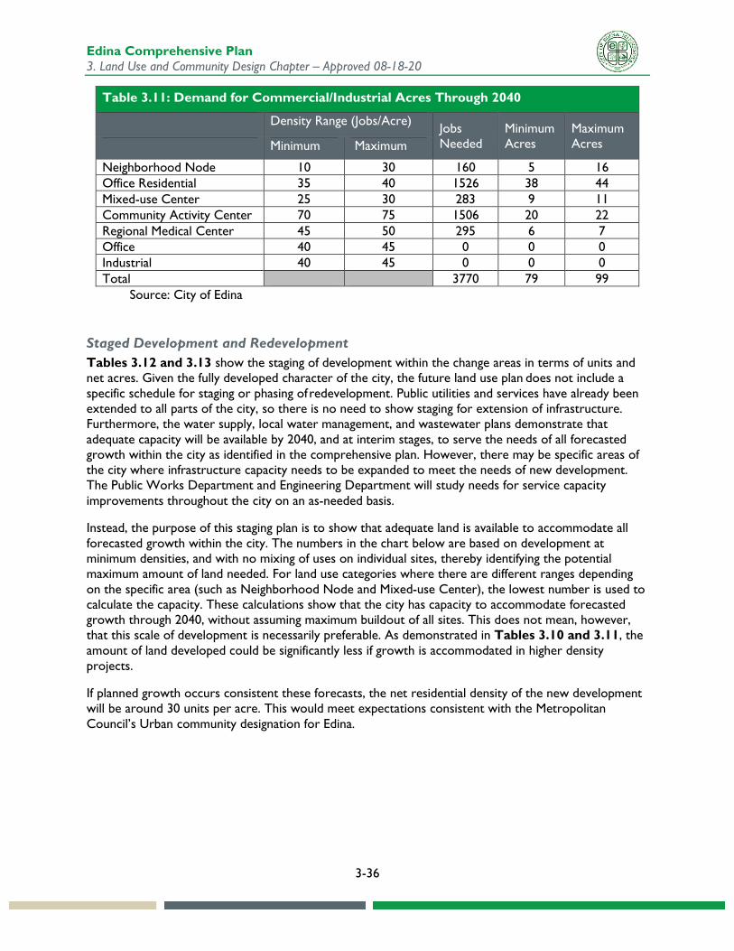
Commercial/Industrial Based on similar assumptions, Edina will need 79-99 acres of land for commercial/industrial uses. This assumes no net loss of existing jobs in these areas, so the actual totals may be higher if there is a redevelopment of sites that removes jobs. Additionally, it is possible that the density range for jobs may be higher or lower in some cases, depending on the scale and intensity of the development and whether it is a mixed-use.
The total acres of commercial or mixed-use land in these change areas is around 571 acres, so this estimates that between 14% to 17% of that total will be impacted by commercial/industrial development by 2040.
Edina Comprehensive Plan 3. Land Use and Community Design Chapter – Approved 08-18-20
3-36
Table 3.11: Demand for Commercial/Industrial Acres Through 2040
Density Range (Jobs/Acre) Jobs Needed
Minimum Acres
Maximum Acres Minimum Maximum
Neighborhood Node 10 30 160 5 16 Office Residential 35 40 1526 38 44 Mixed-use Center 25 30 283 9 11 Community Activity Center 70 75 1506 20 22 Regional Medical Center 45 50 295 6 7 Office 40 45 0 0 0 Industrial 40 45 0 0 0 Total 3770 79 99
Source: City of Edina
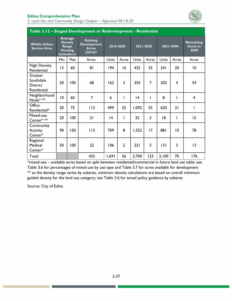
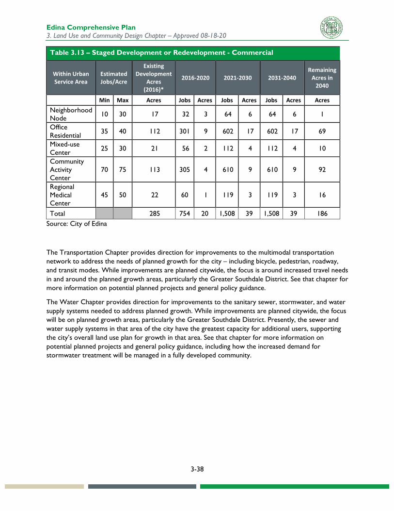
Staged Development and Redevelopment Tables 3.12 and 3.13 show the staging of development within the change areas in terms of units and net acres. Given the fully developed character of the city, the future land use plan does not include a specific schedule for staging or phasing of redevelopment. Public utilities and services have already been extended to all parts of the city, so there is no need to show staging for extension of infrastructure. Furthermore, the water supply, local water management, and wastewater plans demonstrate that adequate capacity will be available by 2040, and at interim stages, to serve the needs of all forecasted growth within the city as identified in the comprehensive plan. However, there may be specific areas of the city where infrastructure capacity needs to be expanded to meet the needs of new development. The Public Works Department and Engineering Department will study needs for service capacity improvements throughout the city on an as-needed basis.
Instead, the purpose of this staging plan is to show that adequate land is available to accommodate all forecasted growth within the city. The numbers in the chart below are based on development at minimum densities, and with no mixing of uses on individual sites, thereby identifying the potential maximum amount of land needed. For land use categories where there are different ranges depending on the specific area (such as Neighborhood Node and Mixed-use Center), the lowest number is used to calculate the capacity. These calculations show that the city has capacity to accommodate forecasted growth through 2040, without assuming maximum buildout of all sites. This does not mean, however, that this scale of development is necessarily preferable. As demonstrated in Tables 3.10 and 3.11, the amount of land developed could be significantly less if growth is accommodated in higher density projects.
If planned growth occurs consistent these forecasts, the net residential density of the new development will be around 30 units per acre. This would meet expectations consistent with the Metropolitan Council’s Urban community designation for Edina.
Edina Comprehensive Plan 3. Land Use and Community Design Chapter – Approved 08-18-20
3-37
Table 3.12 – Staged Development or Redevelopment - Residential
Within Urban Service Area
Average Density Range
Housing Units/Acre
Existing Development
Acres (2016)*
2016-2020 2021-2030 2031-2040 Remaining
Acres in 2040
Min Max Acres Units Acres Units Acres Units Acres Acres
High Density Residential 12 60 81 194 16 425 35 241 20 10
Greater Southdale District Residential
50 100 68 162 3 355 7 202 4 54
Neighborhood Node* ** 10 60 7 6 1 14 1 8 1 4
Office Residential* 20 75 112 499 25 1,092 55 620 31 1
Mixed-use Center* ** 20 100 21 14 1 32 3 18 1 15
Community Activity Center*
90 150 113 709 8 1,552 17 881 10 78
Regional Medical Center*
50 100 22 106 2 231 5 131 3 13
Total 425 1,691 56 3,700 123 2,100 70 176 *mixed-use – available acres based on split between residential/commercial in future land use table; see Table 3.6 for percentages of mixed use by use type and Table 3.7 for acres available for development ** as the density range varies by subarea, minimum density calculations are based on overall minimum guided density for the land use category; see Table 3.6 for actual policy guidance by subarea
Source: City of Edina
Edina Comprehensive Plan 3. Land Use and Community Design Chapter – Approved 08-18-20
3-38
Table 3.13 – Staged Development or Redevelopment - Commercial
Within Urban Service Area
Estimated Jobs/Acre
Existing Development
Acres (2016)*
2016-2020 2021-2030 2031-2040 Remaining
Acres in 2040
Min Max Acres Jobs Acres Jobs Acres Jobs Acres Acres Neighborhood Node 10 30 17 32 3 64 6 64 6 1
Office Residential 35 40 112 301 9 602 17 602 17 69
Mixed-use Center 25 30 21 56 2 112 4 112 4 10
Community Activity Center
70 75 113 305 4 610 9 610 9 92
Regional Medical Center
45 50 22 60 1 119 3 119 3 16
Total 285 754 20 1,508 39 1,508 39 186 Source: City of Edina
The Transportation Chapter provides direction for improvements to the multimodal transportation network to address the needs of planned growth for the city – including bicycle, pedestrian, roadway, and transit modes. While improvements are planned citywide, the focus is around increased travel needs in and around the planned growth areas, particularly the Greater Southdale District. See that chapter for more information on potential planned projects and general policy guidance.
The Water Chapter provides direction for improvements to the sanitary sewer, stormwater, and water supply systems needed to address planned growth. While improvements are planned citywide, the focus will be on planned growth areas, particularly the Greater Southdale District. Presently, the sewer and water supply systems in that area of the city have the greatest capacity for additional users, supporting the city’s overall land use plan for growth in that area. See that chapter for more information on potential planned projects and general policy guidance, including how the increased demand for stormwater treatment will be managed in a fully developed community.
Edina Comprehensive Plan 3. Land Use and Community Design Chapter – Approved 08-18-20
3-39
Community Design Guidelines In order for Edina to remain economically competitive, attractive to residents, businesses, and visitors, and sustainable, the community must be more than functionally responsive. Edina must also be beautiful, vibrant, safe, inclusive, and promote active living. The principles and guidelines in this chapter are intended to help the City achieve this vision by focusing on the design of the built environment and the natural environment. The community design principles apply to both City actions and private sector development. The City is responsible for designing, maintaining and improving its streets, parks, public buildings and other public spaces. The private sector is encouraged to design buildings, structures and landscape features that complement and support the public realm and fit within the context of the surrounding neighborhoods or districts.
This section provides principles and guidelines for buildings, site design, and interconnecting spaces. The 2008 comprehensive plan also included guidance for citywide movement patterns and public spaces. This has subsequently been replaced by the Living Streets Plan (2015). Living streets balance the needs of motorists, bicyclists, pedestrians and transit riders in ways that promote safety and convenience, enhance community identity, create economic vitality, improve environmental sustainability, and provide meaningful opportunities for active living and better health. The Living Streets Plan defines Edina's vision for living streets and addresses how the vision is implemented by providing information on street design, traffic calming, bike facilities, landscaping and lighting, as well as best practices for community engagement during the design process. See the Transportation Chapter for additional information on how the Living Streets Plan is incorporated in the comprehensive plan.
As a largely developed city, Edina’s future growth will be built on infill and redevelopment sites and will need to fit in, improving the character of surrounding areas. The small area plans provide more detailed guidance for specific redevelopment areas of the city. The following overall principles, focused primarily on aesthetic issues, provide general guidance when redevelopment occurs.
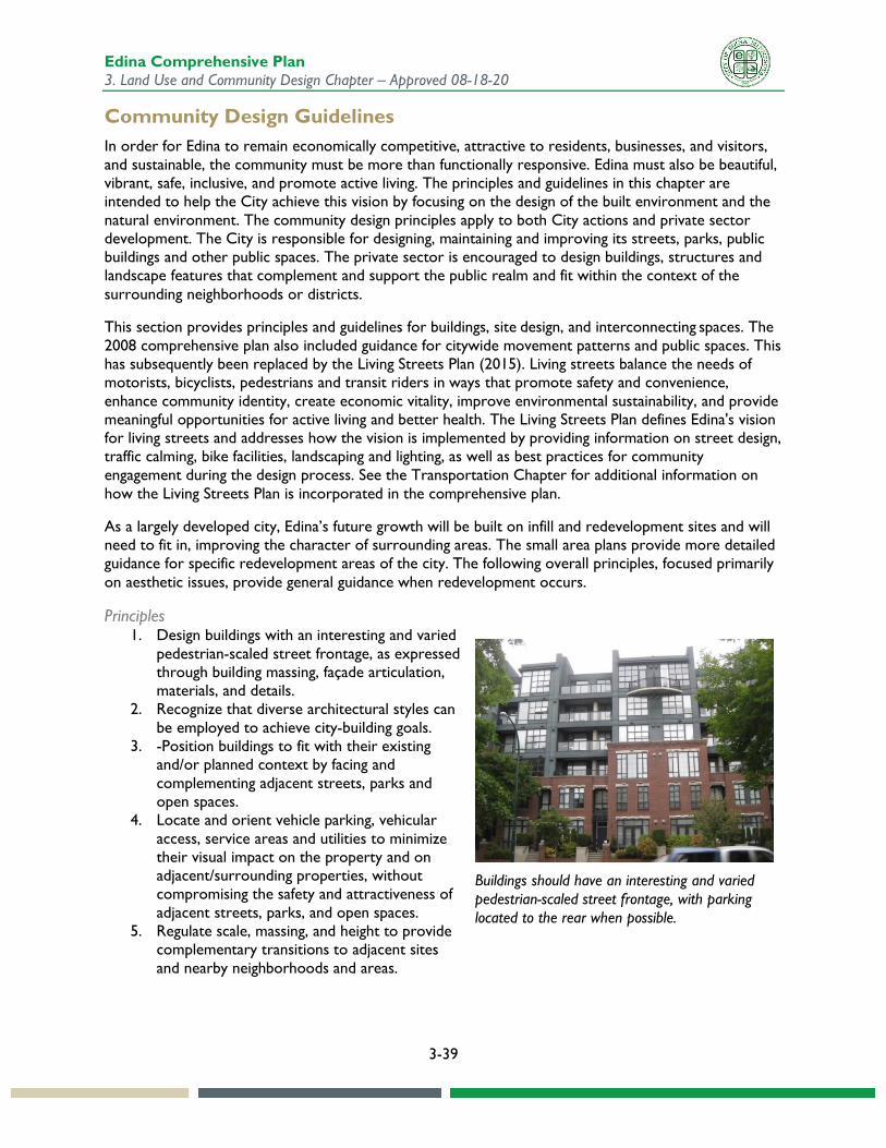
Principles 1. Design buildings with an interesting and varied
pedestrian-scaled street frontage, as expressed through building massing, façade articulation, materials, and details.
2. Recognize that diverse architectural styles can be employed to achieve city-building goals.
3. -Position buildings to fit with their existing and/or planned context by facing and complementing adjacent streets, parks and open spaces.
4. Locate and orient vehicle parking, vehicular access, service areas and utilities to minimize their visual impact on the property and on adjacent/surrounding properties, without compromising the safety and attractiveness of adjacent streets, parks, and open spaces.
5. Regulate scale, massing, and height to provide complementary transitions to adjacent sites and nearby neighborhoods and areas.
Buildings should have an interesting and varied pedestrian-scaled street frontage, with parking located to the rear when possible.
Edina Comprehensive Plan 3. Land Use and Community Design Chapter – Approved 08-18-20
3-40
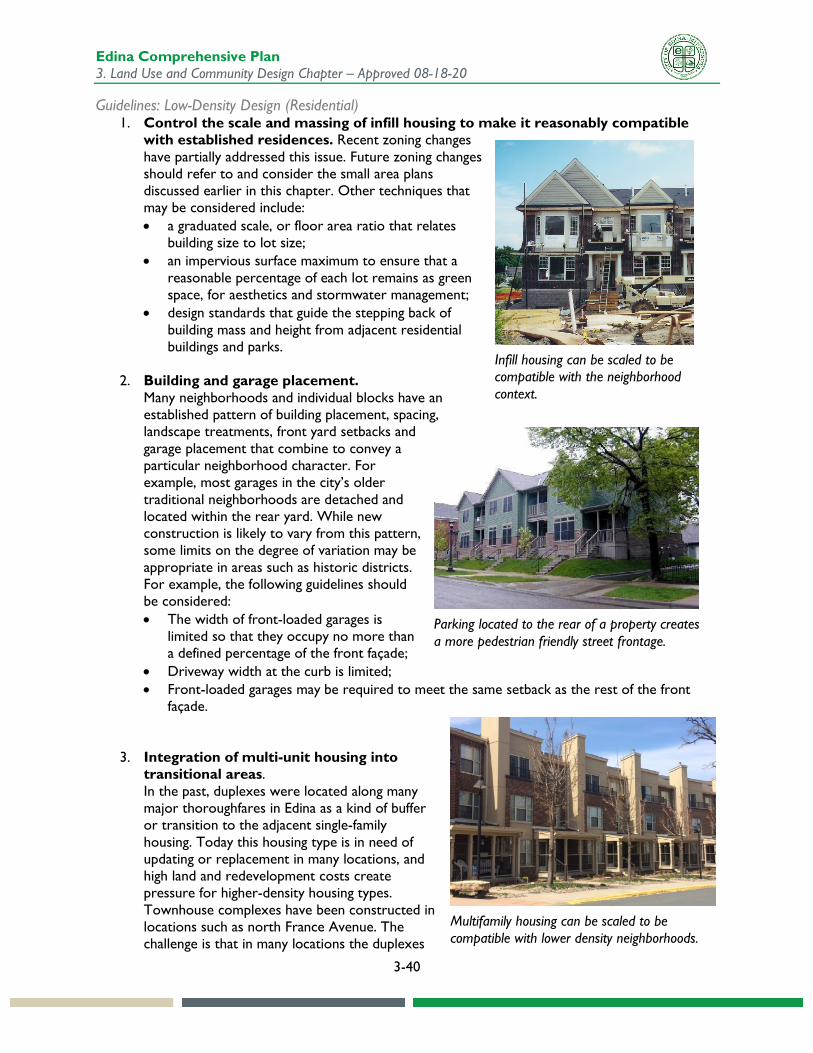
Guidelines: Low-Density Design (Residential) 1. Control the scale and massing of infill housing to make it reasonably compatible
with established residences. Recent zoning changes have partially addressed this issue. Future zoning changes should refer to and consider the small area plans discussed earlier in this chapter. Other techniques that may be considered include: • a graduated scale, or floor area ratio that relates
building size to lot size; • an impervious surface maximum to ensure that a
reasonable percentage of each lot remains as green space, for aesthetics and stormwater management;
• design standards that guide the stepping back of building mass and height from adjacent residential buildings and parks.
2. Building and garage placement. Many neighborhoods and individual blocks have an established pattern of building placement, spacing, landscape treatments, front yard setbacks and garage placement that combine to convey a particular neighborhood character. For example, most garages in the city’s older traditional neighborhoods are detached and located within the rear yard. While new construction is likely to vary from this pattern, some limits on the degree of variation may be appropriate in areas such as historic districts. For example, the following guidelines should be considered: • The width of front-loaded garages is
limited so that they occupy no more than a defined percentage of the front façade;
• Driveway width at the curb is limited; • Front-loaded garages may be required to meet the same setback as the rest of the front
façade.
3. Integration of multi-unit housing into
transitional areas. In the past, duplexes were located along many major thoroughfares in Edina as a kind of buffer or transition to the adjacent single-family housing. Today this housing type is in need of updating or replacement in many locations, and high land and redevelopment costs create pressure for higher-density housing types. Townhouse complexes have been constructed in locations such as north France Avenue. The challenge is that in many locations the duplexes
Infill housing can be scaled to be compatible with the neighborhood context.
Parking located to the rear of a property creates a more pedestrian friendly street frontage.
Multifamily housing can be scaled to be compatible with lower density neighborhoods.
Edina Comprehensive Plan 3. Land Use and Community Design Chapter – Approved 08-18-20
3-41
are only one lot deep, which makes it difficult to provide an adequate transition to single-family scale. The following sections broadly address the issue of integrating multi-unit housing into lower-density, primarily single-family neighborhood transitional areas.
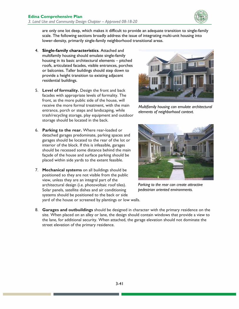
4. Single-family characteristics. Attached and multifamily housing should emulate single-family housing in its basic architectural elements – pitched roofs, articulated facades, visible entrances, porches or balconies. Taller buildings should step down to provide a height transition to existing adjacent residential buildings.
5. Level of formality. Design the front and back facades with appropriate levels of formality. The front, as the more public side of the house, will receive the more formal treatment, with the main entrance, porch or steps and landscaping, while trash/recycling storage, play equipment and outdoor storage should be located in the back.
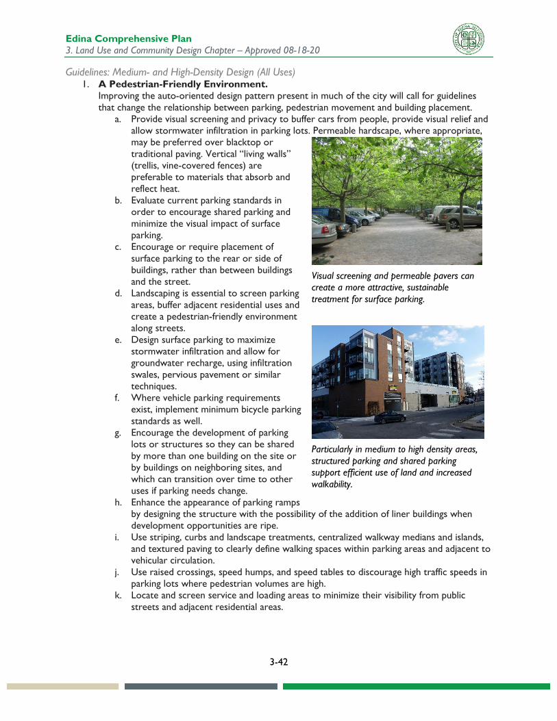
6. Parking to the rear. Where rear-loaded or detached garages predominate, parking spaces and garages should be located to the rear of the lot or interior of the block. If this is infeasible, garages should be recessed some distance behind the main façade of the house and surface parking should be placed within side yards to the extent feasible.
7. Mechanical systems on all buildings should be positioned so they are not visible from the public view, unless they are an integral part of the architectural design (i.e. photovoltaic roof tiles). Solar panels, satellite dishes and air conditioning systems should be positioned to the back or side yard of the house or screened by plantings or low walls.
8. Garages and outbuildings should be designed in character with the primary residence on the site. When placed on an alley or lane, the design should contain windows that provide a view to the lane, for additional security. When attached, the garage elevation should not dominate the street elevation of the primary residence.
Parking to the rear can create attractive pedestrian oriented environments.
Multifamily housing can emulate architectural elements of neighborhood context.
Edina Comprehensive Plan 3. Land Use and Community Design Chapter – Approved 08-18-20
3-42
Guidelines: Medium- and High-Density Design (All Uses) 1. A Pedestrian-Friendly Environment.
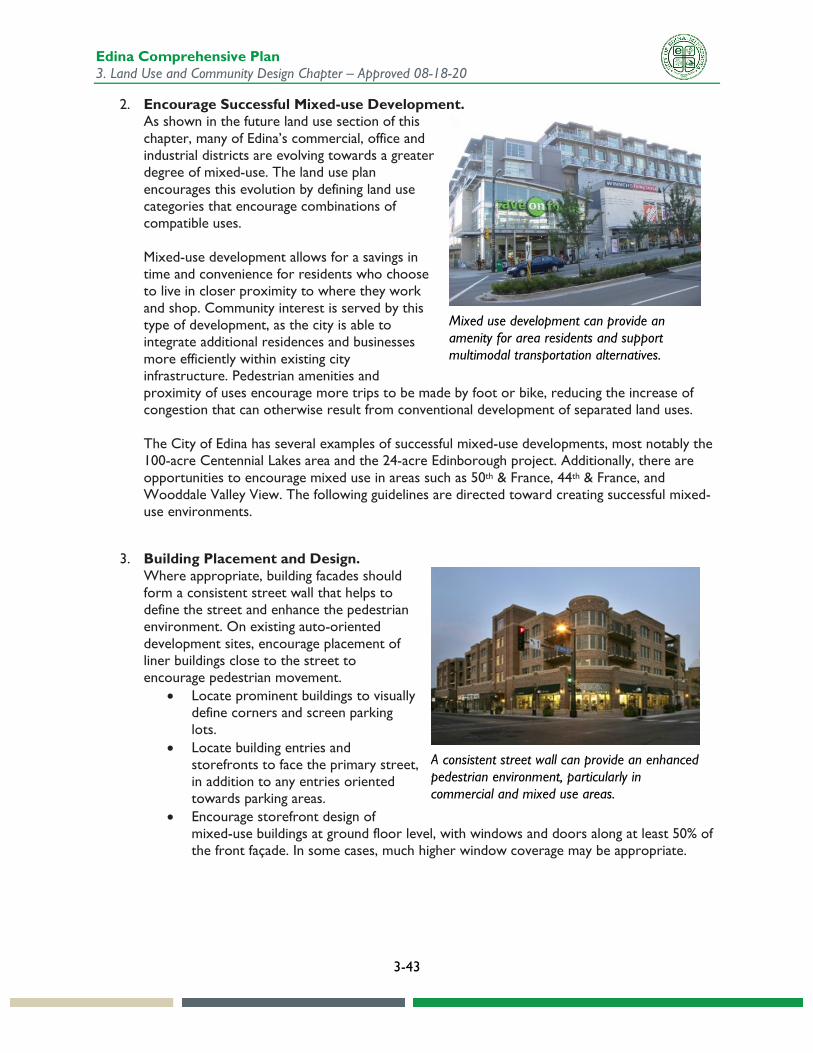
Improving the auto-oriented design pattern present in much of the city will call for guidelines that change the relationship between parking, pedestrian movement and building placement.
a. Provide visual screening and privacy to buffer cars from people, provide visual relief and allow stormwater infiltration in parking lots. Permeable hardscape, where appropriate, may be preferred over blacktop or traditional paving. Vertical “living walls” (trellis, vine-covered fences) are preferable to materials that absorb and reflect heat.
b. Evaluate current parking standards in order to encourage shared parking and minimize the visual impact of surface parking.
c. Encourage or require placement of surface parking to the rear or side of buildings, rather than between buildings and the street.
d. Landscaping is essential to screen parking areas, buffer adjacent residential uses and create a pedestrian-friendly environment along streets.
e. Design surface parking to maximize stormwater infiltration and allow for groundwater recharge, using infiltration swales, pervious pavement or similar techniques.
f. Where vehicle parking requirements exist, implement minimum bicycle parking standards as well.
g. Encourage the development of parking lots or structures so they can be shared by more than one building on the site or by buildings on neighboring sites, and which can transition over time to other uses if parking needs change.
h. Enhance the appearance of parking ramps by designing the structure with the possibility of the addition of liner buildings when development opportunities are ripe.
i. Use striping, curbs and landscape treatments, centralized walkway medians and islands, and textured paving to clearly define walking spaces within parking areas and adjacent to vehicular circulation.
j. Use raised crossings, speed humps, and speed tables to discourage high traffic speeds in parking lots where pedestrian volumes are high.
k. Locate and screen service and loading areas to minimize their visibility from public streets and adjacent residential areas.
Visual screening and permeable pavers can create a more attractive, sustainable treatment for surface parking.
Particularly in medium to high density areas, structured parking and shared parking support efficient use of land and increased walkability.
Edina Comprehensive Plan 3. Land Use and Community Design Chapter – Approved 08-18-20
3-43
2. Encourage Successful Mixed-use Development. As shown in the future land use section of this chapter, many of Edina’s commercial, office and industrial districts are evolving towards a greater degree of mixed-use. The land use plan encourages this evolution by defining land use categories that encourage combinations of compatible uses. Mixed-use development allows for a savings in time and convenience for residents who choose to live in closer proximity to where they work and shop. Community interest is served by this type of development, as the city is able to integrate additional residences and businesses more efficiently within existing city infrastructure. Pedestrian amenities and proximity of uses encourage more trips to be made by foot or bike, reducing the increase of congestion that can otherwise result from conventional development of separated land uses. The City of Edina has several examples of successful mixed-use developments, most notably the 100-acre Centennial Lakes area and the 24-acre Edinborough project. Additionally, there are opportunities to encourage mixed use in areas such as 50th & France, 44th & France, and Wooddale Valley View. The following guidelines are directed toward creating successful mixed-use environments.
3. Building Placement and Design. Where appropriate, building facades should form a consistent street wall that helps to define the street and enhance the pedestrian environment. On existing auto-oriented development sites, encourage placement of liner buildings close to the street to encourage pedestrian movement.
• Locate prominent buildings to visually define corners and screen parking lots.
• Locate building entries and storefronts to face the primary street, in addition to any entries oriented towards parking areas.
• Encourage storefront design of mixed-use buildings at ground floor level, with windows and doors along at least 50% of the front façade. In some cases, much higher window coverage may be appropriate.
Mixed use development can provide an amenity for area residents and support multimodal transportation alternatives.
A consistent street wall can provide an enhanced pedestrian environment, particularly in commercial and mixed use areas.

Edina Comprehensive Plan 3. Land Use and Community Design Chapter – Approved 08-18-20
3-44
4. Movement Patterns. • Provide sidewalks along primary streets and
connections to adjacent neighborhoods along secondary streets or walkways.
• Limit driveway access from primary streets while encouraging access from secondary streets.
• Encourage enhanced transit stops, including shelters, shade and seating where feasible.
• Provide pedestrian amenities, such as wide sidewalks, street trees, pedestrian-scale lighting, and street furnishings (benches, trash receptacles, etc.).
5. Appropriate Parking Standards. Mixed-use developments often produce an internal capture rate. This refers to residents and workers who obtain goods and services from within the development without making additional vehicle trips. Parking ratios for mixed-use development should reflect the internal capture rate and the shared parking opportunities this type of development offers. In the long term other factors will be impacting parking demand, such as the availability of autonomous vehicles, shared cars, bike and scooter share, and other modes that provide alternatives to driving and parking a car.
6. Improve Connectivity in Large-scale Development. Internal and external connectivity. As part of redevelopment or expansion of large-scale sites, reintroduce an internal local street and pathway network that connects through the site and to suitable entry points at the perimeter. The goal is to encourage pedestrians to reach the site and drivers upon arriving to continue all further movement by foot. As a result, the capacity of internal roads can be reduced and more area devoted to amenities, providing still more incentives to walk. Bicycle facilities should allow residents in surrounding neighborhoods to bike safely to the site. Transit stops should be provided in visible and central locations.
7. “Edge” or transitional uses. Moderately sized liner buildings should be encouraged to soften the edge of large-scale superblock development. Medium-density housing types such as townhouses combined with structured parking may also be an appropriate transitional use.
Adding pedestrian and bicycle amenities and facilities can encourage people to walk and bike to destinations.
Mixed use development provides an opportunity for shared parking between uses.
Connectivity within large developments can support walkability.
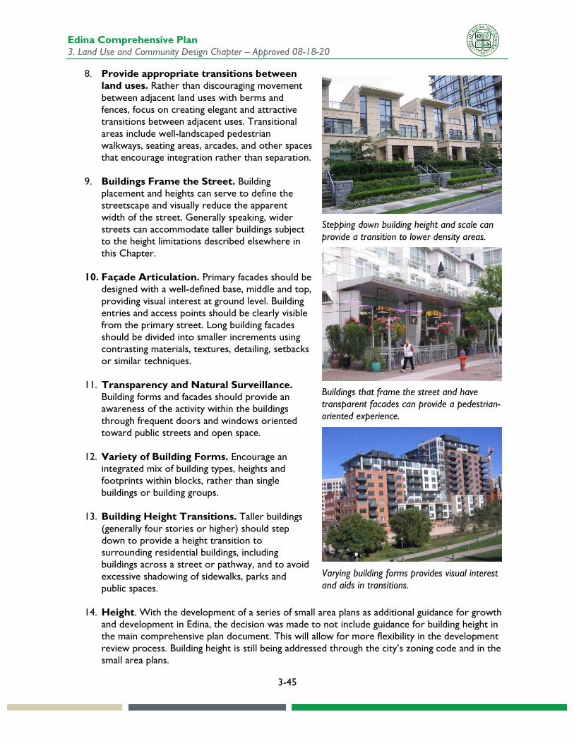
Edina Comprehensive Plan 3. Land Use and Community Design Chapter – Approved 08-18-20
3-45
8. Provide appropriate transitions between land uses. Rather than discouraging movement between adjacent land uses with berms and fences, focus on creating elegant and attractive transitions between adjacent uses. Transitional areas include well-landscaped pedestrian walkways, seating areas, arcades, and other spaces that encourage integration rather than separation.
9. Buildings Frame the Street. Building placement and heights can serve to define the streetscape and visually reduce the apparent width of the street. Generally speaking, wider streets can accommodate taller buildings subject to the height limitations described elsewhere in this Chapter.
10. Façade Articulation. Primary facades should be designed with a well-defined base, middle and top, providing visual interest at ground level. Building entries and access points should be clearly visible from the primary street. Long building facades should be divided into smaller increments using contrasting materials, textures, detailing, setbacks or similar techniques.
11. Transparency and Natural Surveillance. Building forms and facades should provide an awareness of the activity within the buildings through frequent doors and windows oriented toward public streets and open space.
12. Variety of Building Forms. Encourage an integrated mix of building types, heights and footprints within blocks, rather than single buildings or building groups.
13. Building Height Transitions. Taller buildings (generally four stories or higher) should step down to provide a height transition to surrounding residential buildings, including buildings across a street or pathway, and to avoid excessive shadowing of sidewalks, parks and public spaces.
14. Height. With the development of a series of small area plans as additional guidance for growth and development in Edina, the decision was made to not include guidance for building height in the main comprehensive plan document. This will allow for more flexibility in the development review process. Building height is still being addressed through the city’s zoning code and in the small area plans.
Stepping down building height and scale can provide a transition to lower density areas.
Buildings that frame the street and have transparent facades can provide a pedestrian-oriented experience.
Varying building forms provides visual interest and aids in transitions.
Edina Comprehensive Plan 3. Land Use and Community Design Chapter – Approved 08-18-20
3-46
Land Use Goals and Policies Land use goals and policies are provided below. See the Implementation Chapter for related implementation steps, lead implementing agencies, and estimated timelines.
Goal 1: Encourage infill and redevelopment that optimize use of city infrastructure, complement community character, and respond to needs at all stages of life.
1. Endeavor to accommodate private redevelopment in targeted potential areas of change, consistent with future land use guidance.
2. In reviewing development proposals, examine how land use and transportation are integrated to ensure that new development and redevelopment expand nonmotorized travel options that reduce the need for automobile travel.
3. Increase pedestrian and bicycling opportunities and connections between neighborhoods and key destinations, and with other communities, to improve multimodal transportation infrastructure and reduce dependence on cars.
Goal 2: Support livability and high quality of life for all city residents by balancing goals and priorities for development, especially as the community changes over time.
1. Manage transitions and seams between different use, scale, and intensity types to mitigate any negative impacts and encourage positive connections between areas where appropriate.
2. Improve the current development review and approval system to provide clearer direction as to community design goals and encourage high-quality development that is compatible with its surroundings.
3. Incorporate Edina’s tradition of leadership in education throughout the city by providing and encouraging opportunities for residents to engage and learn about the community.
4. Pursue overall goals of promoting equity and reducing disparities in outcomes for people living and working in the community.
Goal 3: Grow and develop sustainably to protect the natural environment, promote energy efficiency, conserve natural resources, and minimize the impacts of buildings on the environment.
1. Incorporate principles of sustainability and energy conservation into all aspects of design, construction, renovation and long-term operation of new and existing development.
2. Encourage efficient use of land through shared functions where appropriate, such as stormwater management incorporated as a community amenity.
3. Maintain the current open space and wetlands acreage and seek to expand it whenever possible. 4. Encourage development types that are designed to function well in all seasons, including winter.
Goal 4: Create and maintain housing options that serve a diverse range of ages, household types, and economic situations.
1. Building on current efforts, seek options that allow for residential redevelopment that is sensitive to the community character and context, while expanding options for residents.
Edina Comprehensive Plan 3. Land Use and Community Design Chapter – Approved 08-18-20
3-47
2. Seek opportunities to increase the supply of affordable housing, as well as to preserve the affordability of existing affordable housing.
3. Facilitate the development of new housing that accommodates the needs of a people of diverse needs and from diverse backgrounds.
4. Investigate opportunities to accommodate Missing Middle housing within the city, defined as range of multi-unit or clustered housing types compatible in scale with single-family homes that help meet the growing demand for walkable urban living.
Goal 5: Support and enhance commercial and mixed-use areas that serve the neighborhoods, the city, and the larger region.
1. Recognize and support commercial, office, and industrial job centers that draw workers from the city and across the region.
2. Increase mixed-use development where supported by adequate infrastructure to minimize traffic congestion, support transit, and diversify the tax base.
3. Support the development of mixed use districts that provide a variety of living opportunities within a walkable and livable area.
Goal 6: Ensure that public realm design respects community character, supports of commercial and mixed-use development, promotes community identity, and creates high quality experiences for pedestrians, cyclists, transit users, and motorists.
1. Ensure that the city’s roads continue to evolve to act as connectors, rather than as barriers. 2. Incorporate amenities and infrastructure into public corridors to make them beautiful, efficient,
and multimodal public spaces that contribute to community identity and pride. 3. Encourage the development of living streets with enhanced public realms and integrated
environmental functions, including potentially functioning as high-integrity ecologic corridors.