Embed Size (px)
Citation preview
South Dakota PrairieWinds Project Chapter 3
3 AFFECTED ENVIRONMENT This chapter describes the baseline condition of the area that could be affected by the Proposed Project. The affected environment, or region of influence (ROI), is the physical area that bounds the environmental, sociological, economic, or cultural feature of interest that could be impacted by construction and operation of the Proposed Project and the proposed Federal actions. The boundaries of the ROI may vary depending on the resource being analyzed. The baseline condition serves as a reference point for the evaluation of impacts presented in Chapter 4, Environmental Consequences. For ease of understanding the evaluation of impacts and correlating Chapters 3 and 4, the document has been prepared so that a resource described in Chapter 3, Affected Environment, has the same section number in Chapter 4, Environmental Consequences (e.g., Section 3.2 Water Resources, Section 4.2 Water Resources).
The Proposed Project affected environment descriptions are presented for the Crow Lake and Winner alternatives. Instances are noted where the affected environment descriptions for the proposed Federal actions differ from those of the Proposed Project alternatives.
Critical Elements of the Human Environment, as defined and specified in the above-listed statutes and Executive Orders, that could be impacted by the Proposed Project include:
• Geology and soils • Water resources • Climate change and air quality • Biological resources • Cultural resources • Land use • Transportation • Visual resources • Noise • Socioeconomics • Environmental justice • Health and safety
Critical elements of the human environment that would not be affected are listed below, followed by the justification for dismissal of these elements from further discussion.
Paleontology – Investigations of publicly available maps and local geology did not identify paleontological resource sites in the Proposed Project area. The glacial till and outwash deposits that comprise the majority of the surface soils in the area are unlikely to contain fossils.
Wild and Scenic Rivers – Review of the U.S. Department of Interior, National Park Service (NPS) website indicates that there are no Federally-designated Wild and Scenic Rivers in South Dakota (NPS 2004).
December 2009 47 DOE/EIS-0418, Draft
Chapter 3 South Dakota PrairieWinds Project
Wilderness – There are no Federally-designated wilderness areas near the Proposed Project alternatives.
3.1 GEOLOGY AND SOILS The ROI for geology and soils includes areas of immediate disturbance associated with implementation of the Proposed Project Components and proposed Federal actions. Because existing data on geologic resources is not available for the specific sites, the geology in the vicinity of the alternatives is summarized.
3.1.1 GEOLOGY
3.1.1.1 Crow Lake Alternative
Information and data for the compilation of this section is from Bulletin 32 – Geology of Aurora and Jerauld Counties, South Dakota (Hedges 2001), Aquifer Materials Map 21 – First Occurrence of Aquifer Materials in Aurora County, South Dakota (Jensen 2004), Aquifer Materials Map 21 – First Occurrence of Aquifer Materials in Jerauld County, South Dakota (Jensen 2005), and Compilation of Resource Technical Memorandums – Crow Lake Project, Portions of Jerauld, Aurora, and Brule Counties, South Dakota (Terracon 2009a).
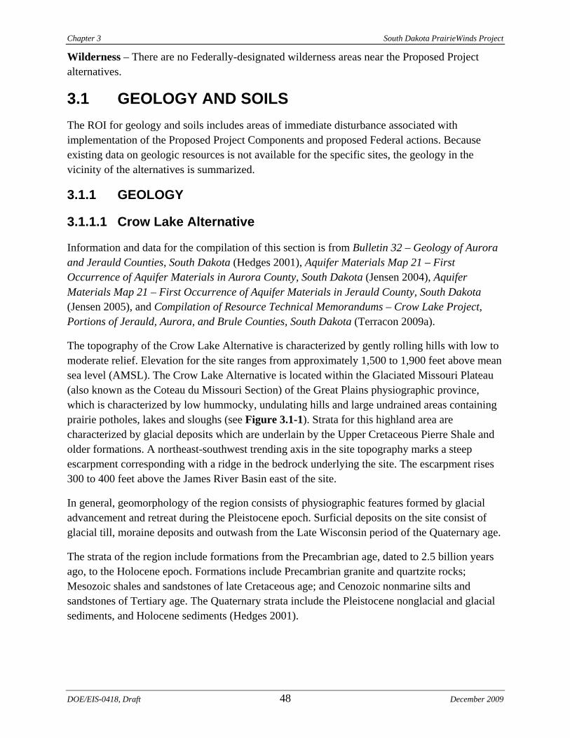
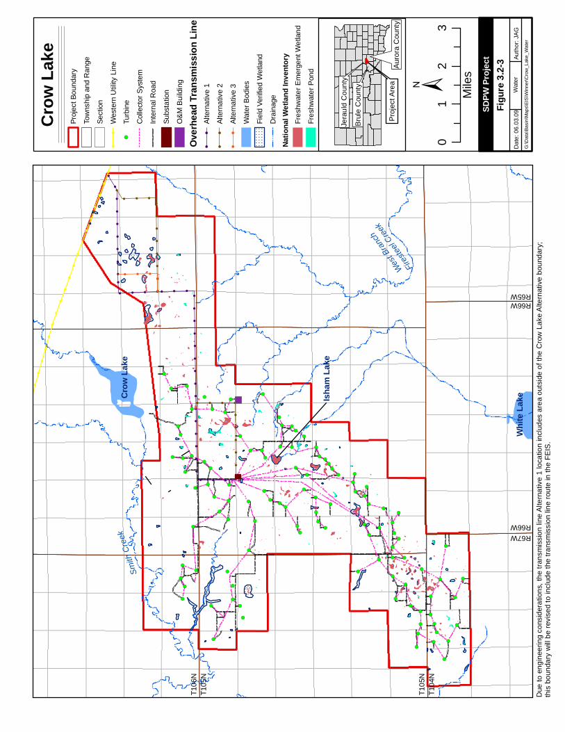
The topography of the Crow Lake Alternative is characterized by gently rolling hills with low to moderate relief. Elevation for the site ranges from approximately 1,500 to 1,900 feet above mean sea level (AMSL). The Crow Lake Alternative is located within the Glaciated Missouri Plateau (also known as the Coteau du Missouri Section) of the Great Plains physiographic province, which is characterized by low hummocky, undulating hills and large undrained areas containing prairie potholes, lakes and sloughs (see Figure 3.1-1). Strata for this highland area are characterized by glacial deposits which are underlain by the Upper Cretaceous Pierre Shale and older formations. A northeast-southwest trending axis in the site topography marks a steep escarpment corresponding with a ridge in the bedrock underlying the site. The escarpment rises 300 to 400 feet above the James River Basin east of the site.
In general, geomorphology of the region consists of physiographic features formed by glacial advancement and retreat during the Pleistocene epoch. Surficial deposits on the site consist of glacial till, moraine deposits and outwash from the Late Wisconsin period of the Quaternary age.
The strata of the region include formations from the Precambrian age, dated to 2.5 billion years ago, to the Holocene epoch. Formations include Precambrian granite and quartzite rocks; Mesozoic shales and sandstones of late Cretaceous age; and Cenozoic nonmarine silts and sandstones of Tertiary age. The Quaternary strata include the Pleistocene nonglacial and glacial sediments, and Holocene sediments (Hedges 2001).
DOE/EIS-0418, Draft 48 December 2009
§̈ ¦90
¬ «47
¬ «44
¬ «45
£ ¤18
£ ¤183
Grea
t Plai
ns Pr
ovinc
eCe
ntral
Lowl
ands
Prov
ince
¬ «34
¬ «45
Ungla
ciated
Miss
ouri P
latea
uGl
aciat
ed M
issou
ri Plat
eau
Weste
rn La
ke
PIE
RR
E H
ILLS
MIS
SO
UR
I CO
TEA
U
JAM
ES
RIV
ER
LO
WLA
ND
SA
ND
HIL
LS
SO
UTH
ER
N P
LATE
AU
S
SA
ND
HIL
LS
SA
ND
HIL
LS
SA
ND
HIL
LS
SO
UTH
ER
N P
LATE
AU
S
SA
ND
HIL
LS
Cro
w L
ake
Win
ner
Phy
siog
raph
ic P
rovi
nce
Phy
siog
raph
ic R
egio
n
Phy
siog
raph
ic S
ectio
n
Sta
te/U
S H
ighw
ay
I-90
Ele
vatio
n (M
eter
s)
Hig
h : 2
144
Low
: 29
2 ±
Alter
nativ
es
09
18
Mile
s
Papa
go R
dD
ate:
06.
10.0
9Au
thor
: JA
GG
:\Dat
a\Ba
sin\
Map
s\EI
S\P
hysi
ogra
phic
_Reg
ions
SDPW
Proje
ct
Phys
iogr
aphi
cR
egio
ns
View
Ext
ent
Figur
e 3.1-
1
Chapter 3 South Dakota PrairieWinds Project
The Pierre Shale of the late Cretaceous age underlies the site and creates the base of the northeast-southeast axis in elevation of the Crow Lake Alternative. The Pierre Shale also occurs as isolated surface outcrops at elevations as high as 1,900 feet AMSL within the site.
Quaternary sediments in the region consist of Pleistocene western-derived nonglacial alluvium, glacial deposits, loess and Holocene alluvium and colluvium. Pleistocene tills comprise the bulk of the Quaternary deposits in the region, although Pleistocene outwash or lake deposits may be substantial. The Quaternary deposits may also include Plio-Pleistocene western-derived fluvial sand and gravel deposits and Holocene alluvium and colluvium. Collectively, these sediments can exceed 500 feet in thickness in the region and comprise the large majority of the surficial sediments (Hedges 2001).
Within the Crow Lake Alternative boundary, the composite thickness of the Upper Wisconsin till may be up to 300 feet. Quaternary sediments occurring at the surface of the site include:
• Undifferentiated glacial outwash – consists of heterogeneous sand and gravel with minor clay and silt. Of glaciofluvial origin, this formation includes outwash plains, kames, kame terraces and other undifferentiated deposits, and is expected to be up to 30 feet thick.
• Stagnation moraine till – includes a compact, silty, clay-rich matrix with sand- to boulder-sized clasts. This glacial, geomorphic feature is characterized by hummocky terrain with abundant sloughs resulting from the stagnation of ice sheets.
• Ground moraine till – also consists of a compact, silty, clay-rich matrix with sand- to boulder-sized clasts. The geomorphic feature is characterized by smooth, rolling terrain formed by glaciers.
• Terrace outwash – occurs at the extreme northwest corner of site represented by heterogeneous clay to gravel of glaciofluvial origin. This formation is expected to be up to 60 feet thick.
• Alluvial deposits are found within the present-day drainage of East Smith Creek.
3.1.1.2 Winner Alternative
Information and data for the compilation of this section is from Ground Water Supply for City of the Winner, South Dakota (Barari 1966), Groundwater Investigation for the City of Colome, South Dakota (Barari 1969), Hydrogeologic Assessment of the High Plains Aquifer in Tripp and Gregory Counties, South Dakota (Filipovic 2004), and Compilation of Resource Technical Memorandums - Winner Project Site, Tripp County, South Dakota (Terracon 2009b).
The Winner Alternative lies within the Great Plains physiographic province. The majority of the site is in the Unglaciated Missouri Plateau Section, which is also described as Tertiary Table Lands or Sand Hills (see Figure 3.1-1). The northeastern-most fringe of the site near the City of Colome is also in the Unglaciated Missouri Plateau Section, but is also described as a part of the Pierre Hills. Areas of the south-central portion of the site are in the Southern Plateaus, which are associated with the High Plains Section of the Great Plains physiographic province.
DOE/EIS-0418, Draft 50 December 2009
South Dakota PrairieWinds Project Chapter 3
December 2009 51 DOE/EIS-0418, Draft
The vicinity of the Winner Alternative is characterized by rolling plains of relatively low relief, developed on the marine rocks of the Pierre Shale. To the south, elevations rise into butte and mesa topography, typical of the Tertiary tablelands. The stratigraphy of the region includes formations from Precambrian, dated to 2.5 billion years ago, to Quaternary age. Similar to the Crow Lake Alternative, formations include Precambrian granite; Cambrian and Ordovician sands; Paleozoic sediments; Cretaceous age shales and sandstones; Cenozoic nonmarine silts; sandstones of Tertiary age; and Quaternary alluvium and eolian sediments.
3.1.2 SOILS
Geographic Information System (GIS) data depicting soil types within and adjacent to the Proposed Project alternatives were obtained from the Natural Resources Conservation Service (NRCS 2009). Soils within the Proposed Project alternatives were overlain on a GIS map of the Proposed Project Components to identify soils within the affected environment.
3.1.2.1 Crow Lake Alternative
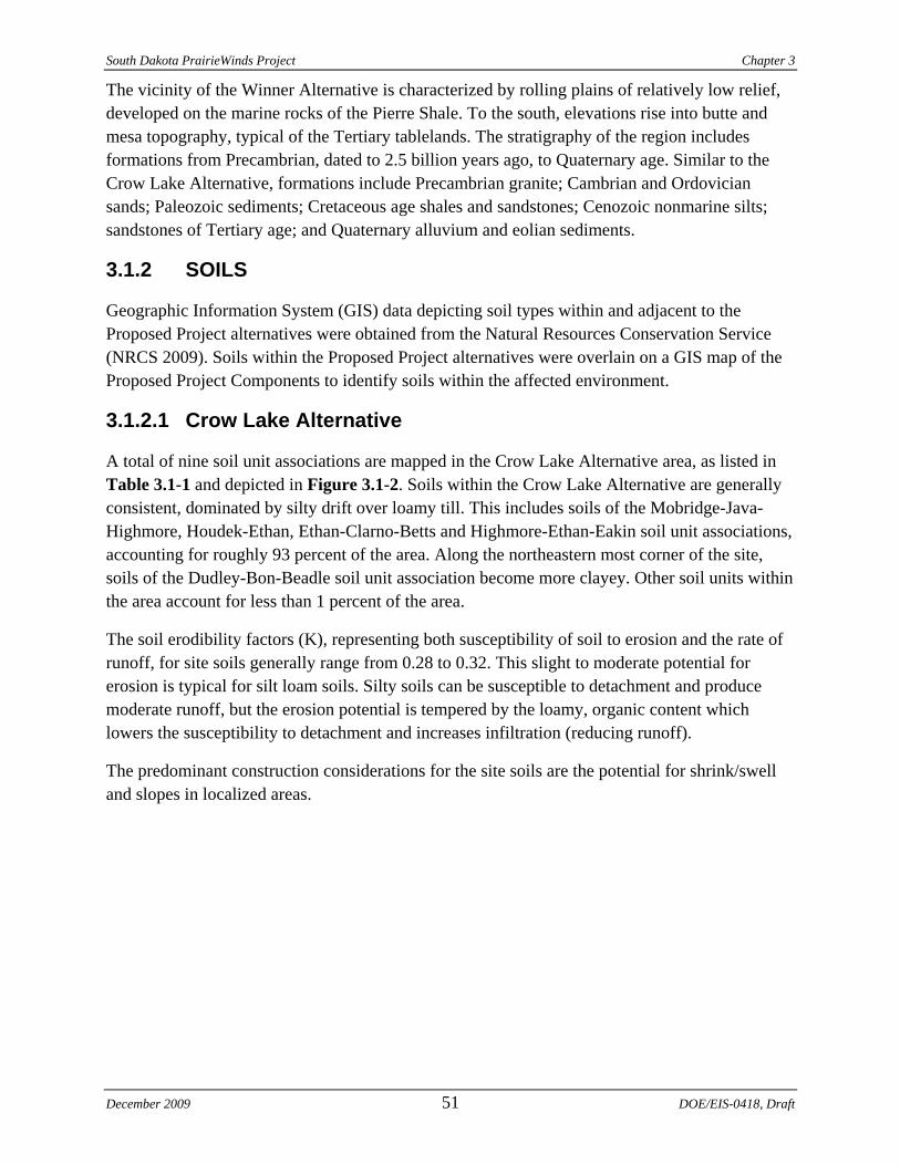
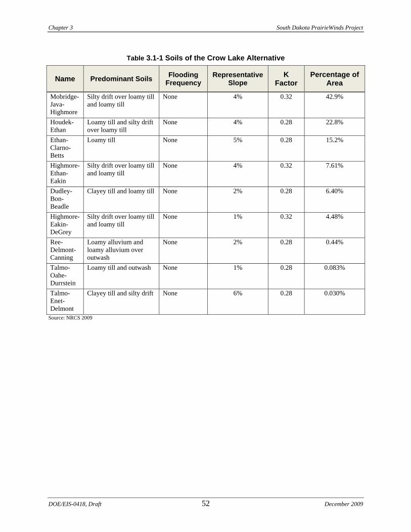
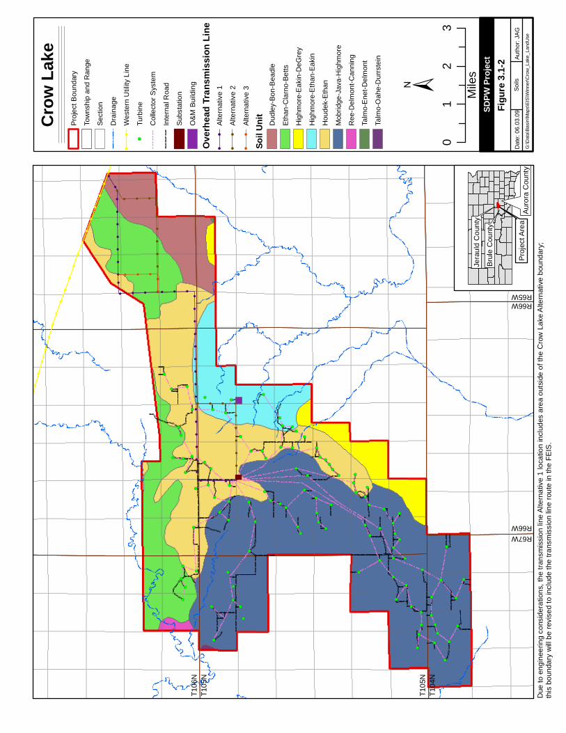
A total of nine soil unit associations are mapped in the Crow Lake Alternative area, as listed in Table 3.1-1 and depicted in Figure 3.1-2. Soils within the Crow Lake Alternative are generally consistent, dominated by silty drift over loamy till. This includes soils of the Mobridge-Java-Highmore, Houdek-Ethan, Ethan-Clarno-Betts and Highmore-Ethan-Eakin soil unit associations, accounting for roughly 93 percent of the area. Along the northeastern most corner of the site, soils of the Dudley-Bon-Beadle soil unit association become more clayey. Other soil units within the area account for less than 1 percent of the area.
The soil erodibility factors (K), representing both susceptibility of soil to erosion and the rate of runoff, for site soils generally range from 0.28 to 0.32. This slight to moderate potential for erosion is typical for silt loam soils. Silty soils can be susceptible to detachment and produce moderate runoff, but the erosion potential is tempered by the loamy, organic content which lowers the susceptibility to detachment and increases infiltration (reducing runoff).
The predominant construction considerations for the site soils are the potential for shrink/swell and slopes in localized areas.
Chapter 3 South Dakota PrairieWinds Project
DOE/EIS-0418, Draft 52 December 2009
Table 3.1-1 Soils of the Crow Lake Alternative
Name Predominant Soils Flooding Frequency
Representative Slope
K Factor
Percentage of Area
Mobridge-Java-Highmore
Silty drift over loamy till and loamy till
None 4% 0.32 42.9%
Houdek-Ethan
Loamy till and silty drift over loamy till
None 4% 0.28 22.8%
Ethan-Clarno-Betts
Loamy till None 5% 0.28 15.2%
Highmore-Ethan-Eakin
Silty drift over loamy till and loamy till
None 4% 0.32 7.61%
Dudley-Bon-Beadle
Clayey till and loamy till None 2% 0.28 6.40%
Highmore-Eakin-DeGrey
Silty drift over loamy till and loamy till
None 1% 0.32 4.48%
Ree-Delmont-Canning
Loamy alluvium and loamy alluvium over outwash
None 2% 0.28 0.44%
Talmo-Oahe-Durrstein
Loamy till and outwash None 1% 0.28 0.083%
Talmo-Enet-Delmont
Clayey till and silty drift None 6% 0.28 0.030%
Source: NRCS 2009
!!
!
!!
!
!
!
!
!
!
!
!
!
!
!
!!
!!
!!
!!
!!
!!
!!
!!
!!
!!
!!
!!
!!
!!
!!
!!
!!
!!
!!
!!
!!
!
!!
!!
!!
!!
!!
!
!!
!!
!!
!!
!!
!!
!
!
!
!
!
!
!
!
!
!
!
!
!
!
!
!
!
!
!
!
!
!
!
!
!
!
!
!
!
!
!
!
!
!
!
!
!
!
!
!
!
!
!
!
!
!
!
!
!
!
!
!
!
!
!
!
!
!
!
!
!
!
!
!
!
!
!
!
!
!
!
!
!
!
!
!
!
!
!
!
!
!
!
!
!
!
!
!
!
!
!
!
!
!
!
!
!
!
!
!
!
!
!
!
!
!
!
!
!
!
!
!
!
!
!
!
!
!
!
!
!
!
!
!
!
!
!
!
!
!
!
!
!
!
!
!
!
!
!
!
!
!
!
!
!
!
!
!
!
!
!
!
!
!
!
!
!
!
!
!
!
!
!
!
!
!
!
!
!
!
!
!
!
!
!
!
!
!
!
!
!
!
!
!
!
!
!
!
!
!
!
!
!
!
!
!
!
!
!
!
!
!
!
!
!
!
!
!
!
!
!
!
!
!
!
!
!
!
!
!
!
!
!
!
!
!
!
!
!
!
!
!
!
!
!
!
!
!
!
!
!
!
!
!!
!
!
!
!!
!
!
!
!
!
!
!
!
!
!
!
!
!
!
!
!
!
!
!
!
!
!
!
!
!
!
!
!
!
!
!
!
!
!
!
!
!!!
!!
!!
!!
!!
!!
!!
!!
!
!!!
!!
!!
!!
!!
!
!!!!
!
!!
!!
!!
!!
!!!
!
!!
!!
!!
!!!!
! (
! (
! (
! (
! (
! (
! (
! (
! (
! (
! (
! (
! (
! (
! (
! (
! (
! (
! (
! (
! (
! (
! (
! (
! (
! (
! (
! (
! (
! (
! (
! (
! (
! (
! (
! (
! (
! (
! (
! (
! (
! (
! (
! (
! (
! (
! (
! (
! (
! (
! (
! (
! (
! (
! (
! (
! (
! (
! (
! (
! (
! (
! (
! (
! (
! (
! (
! (
! (
! (
! (
! (! (
! (
! (
! (
! (
! (
! (
! (
! (
! (
! (
! (
! (
! (
! (
! (
! (
! (
! (
! (
! (
! (
! (
! (
! (
! (
! (
! (
! (
! (
! (
! (
! (
! (
! (
! (
! (
! (
! (
!!
!!!
±
Crow
Lake
Proj
ect B
ound
ary
Tow
nshi
p an
d R
ange
Sect
ion
Dra
inag
e!
!W
este
rn U
tility
Lin
e
!(Tu
rbin
e
Col
lect
or S
yste
m
Inte
rnal
Roa
d
Subs
tatio
n
O&M
Bui
ldin
g
Overh
ead T
rans
miss
ion Li
ne!
!Al
tern
ativ
e 1
!!
Alte
rnat
ive
2
!!
Alte
rnat
ive
3
Soil U
nit Dud
ley-
Bon-
Bea
dle
Etha
n-C
larn
o-Be
tts
Hig
hmor
e-E
akin
-DeG
rey
Hig
hmor
e-E
than
-Eak
in
Hou
dek-
Etha
n
Mob
ridge
-Jav
a-H
ighm
ore
Ree
-Del
mon
t-Can
ning
Talm
o-E
net-D
elm
ont
Talm
o-O
ahe-
Dur
rste
in
01
23
Mile
s
Papa
go R
dD
ate:
06.
03.0
9Au
thor
: JA
GG
:\Dat
a\Ba
sin\
Map
s\EI
S\W
inne
r\Cro
w_L
ake_
Land
Use
SDPW
Proje
ct
Soils
Jera
uld
Cou
nty
Pro
ject
Are
aA
uror
a C
ount
y
Bru
le C
ount
y
R67WR66W
R66WR65WT1
04N
T105
N
T105
NT1
06N
Figur
e 3.1-
2
Due
to e
ngin
eerin
g co
nsid
erat
ions
, the
tran
smis
sion
line
Alte
rnat
ive
1 lo
catio
n in
clud
es a
rea
outs
ide
of th
e C
row
Lak
e A
ltern
ativ
e bo
unda
ry;
this
bou
ndar
y w
ill b
e re
vise
d to
incl
ude
the
trans
mis
sion
line
rout
e in
the
FEIS
.
Chapter 3 South Dakota PrairieWinds Project
3.1.2.2 Winner Alternative
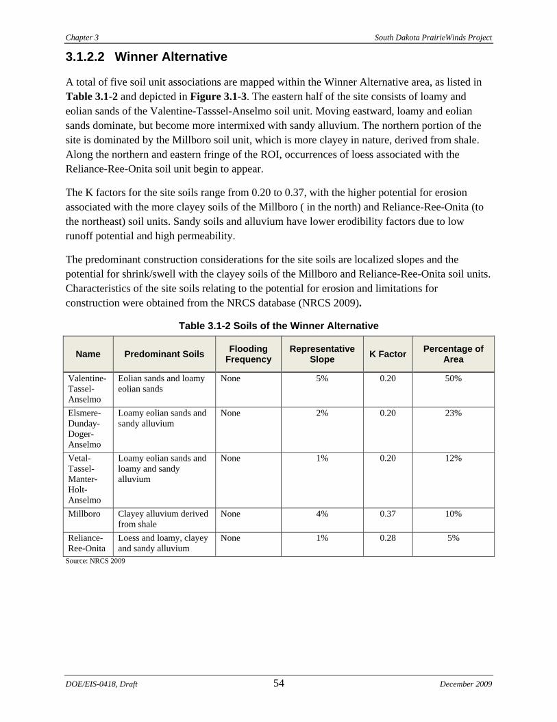
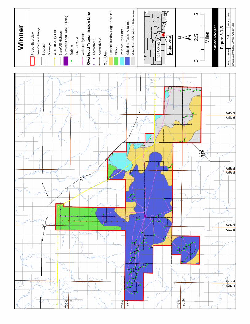
A total of five soil unit associations are mapped within the Winner Alternative area, as listed in Table 3.1-2 and depicted in Figure 3.1-3. The eastern half of the site consists of loamy and eolian sands of the Valentine-Tasssel-Anselmo soil unit. Moving eastward, loamy and eolian sands dominate, but become more intermixed with sandy alluvium. The northern portion of the site is dominated by the Millboro soil unit, which is more clayey in nature, derived from shale. Along the northern and eastern fringe of the ROI, occurrences of loess associated with the Reliance-Ree-Onita soil unit begin to appear.
The K factors for the site soils range from 0.20 to 0.37, with the higher potential for erosion associated with the more clayey soils of the Millboro ( in the north) and Reliance-Ree-Onita (to the northeast) soil units. Sandy soils and alluvium have lower erodibility factors due to low runoff potential and high permeability.
The predominant construction considerations for the site soils are localized slopes and the potential for shrink/swell with the clayey soils of the Millboro and Reliance-Ree-Onita soil units. Characteristics of the site soils relating to the potential for erosion and limitations for construction were obtained from the NRCS database (NRCS 2009).
Table 3.1-2 Soils of the Winner Alternative
Name Predominant Soils Flooding Frequency
Representative Slope K Factor Percentage of
Area
Valentine-Tassel-Anselmo
Eolian sands and loamy eolian sands
None 5% 0.20 50%
Elsmere-Dunday-Doger-Anselmo
Loamy eolian sands and sandy alluvium
None 2% 0.20 23%
Vetal-Tassel-Manter-Holt-Anselmo
Loamy eolian sands and loamy and sandy alluvium
None 1% 0.20 12%
Millboro Clayey alluvium derived from shale
None 4% 0.37 10%
Reliance-Ree-Onita
Loess and loamy, clayey and sandy alluvium
None 1% 0.28 5%
Source: NRCS 2009
DOE/EIS-0418, Draft 54 December 2009
!!
!!
!!
!!
!!
!!
!!
!!
!!
!!
!!
!!
!!
!!
!
!
!
!
!
!
!
!
!
!
!
!
!
!
!
!
!
!
!
!!
!!
!!
!!
!!
!!
!!
!!
!!
!!
!!
!
!
!
!
!
!
!
!
!
!
!
!
!
!
!
!
!
!
!
!
!
!
!
!
!
!
!
!
!
!
!!
!!
!!
!!
!!
!!
!!
!!
!!
!!
!!
!!
!!
!!
!!
!!
!!
!!
!!
!!
!!
!!
!
!
!!!!!!!!!!!!!!!
!
!!!!!!!!!!!
!
!(
!(
!(
!(
!(
!(!(
!(!(
!(
!(
!(
!( !(
!(
!(
!(
!(
!(
!(
!(
!(
!(
!(
!(
!(
!(
!(!(
!(!(
!(
!(
!(
!(!(
!(
!(
!(
!(
!(
!(
!(
!(
!(
!(
!( !(
!(
!(
!(
!( !(
!(
!(
!(
!(
!(
!(
!(
!(
!(
!(
!(
!(
!(
!(
!(
!(
!(
!(
!(
!(
!(
!(
!(
!(
!(
!(
!(
!(
!(
!(
!(!(
!(
!(
!(
!(
!(
!(
!(
!(
!(
!(!(
!(
!(
!(
!(
!(
!(
!(
!(
!(
!(
!(
!(!(
!(
!(
¬ «44
£ ¤18
£ ¤183
±
Winn
erPr
ojec
t Bou
ndar
y
Tow
nshi
p an
d R
ange
Sect
ions
Dra
inag
e!
!W
este
rn U
tility
Lin
e
Stat
e/U
S H
ighw
ay
Subs
tatio
n an
d O
&M B
uild
ing
!(Tu
rbin
e
Inte
rnal
Roa
d
Col
lect
or S
yste
m
Over
head
Tran
smiss
ion Li
ne!
!Al
tern
ativ
e 1
!!
Alte
rnat
ive
2
Soil U
nit Elsm
ere-
Dun
day-
Dog
er-A
nsel
mo
Mill
boro
Rel
ianc
e-R
ee-O
nita
Vale
ntin
e-Ta
ssel
-Ans
elm
o
Veta
l-Tas
sel-M
ante
r-Hol
t-Ans
elm
o
02.
55
Mile
s
Papa
go R
dD
ate:
07.
29.0
9Au
thor
: JH
RG
:\Dat
a\Ba
sin\
Map
s\EI
S\W
inne
r\Win
ner_
Soi
ls
SDPW
Proje
ct
Soils
Trip
p C
ount
y
Pro
ject
Are
a
R77WR76W
R76WR75W
T966
NT9
7N
T98N
T99N
R78WR77W
R75WR74W
T97N
T98N
Figur
e 3.1-
3
Chapter 3 South Dakota PrairieWinds Project
3.2 WATER RESOURCES The ROI for water resources encompasses hydrologic systems that could be impacted by discharges, spills and/or stormwater runoff associated with implementing the Proposed Project and proposed Federal actions.
3.2.1 SURFACE WATER RESOURCES
The Crow Lake and Winner alternatives are within the Missouri River Basin surface water drainage system. This system includes a watershed of approximately 529,350 square miles, including about 9,700 square miles in Canada (USACE 2006). The Missouri River Basin surface water drainage system consists of region, subregion, basin and subbasin drainages in accordance with hydrologic unit maps published by the U.S. Geological Survey (USGS). Six mainstem reservoir system dams line the Missouri River (beginning upstream): Fort Peck, Garrison, Oahe, Big Bend, Fort Randall and Gavins Point.
In the vicinity of the two sites, Fort Randall Dam on the Missouri River forms Lake Francis Case, and accepts drainage from the White River. Below the Fort Randall Dam is Gavins Point Dam, which impounds Lewis & Clark Lake. Ponca Creek and the Niobrara River join the Missouri River downstream of Fort Randall Dam, above Lewis & Clark Lake. The James River flows into the Missouri River downstream of Gavins Point Dam.
The following sections describe the path of surface water flows from within the alternative site boundaries to their confluence with the Missouri River. Impaired waters, listed under Section 303(d) of the CWA, within the flow path to the Missouri River are also discussed. Impaired waters do not meet water quality standards due to pollution or other degradation.
3.2.1.1 Crow Lake Alternative
The Crow Lake Alternative is within the prairie pothole region of the northern Great Plains. As described in Section 3.1, well-drained, hilly terrain dominates the site along the northern and western side of a noticeable northeast-southwest trending axis in the site topography. The poorly drained prairie pothole areas and water-holding sloughs are along the eastern side of this axis. Intermittent streams are prevalent at the Crow Lake Alternative, and the stream drainages are dendritic, resembling the branching pattern of blood vessels or tree branches. Various intermittent and perennial lakes and ponds associated with prairie potholes and intermittent streams are throughout the site.
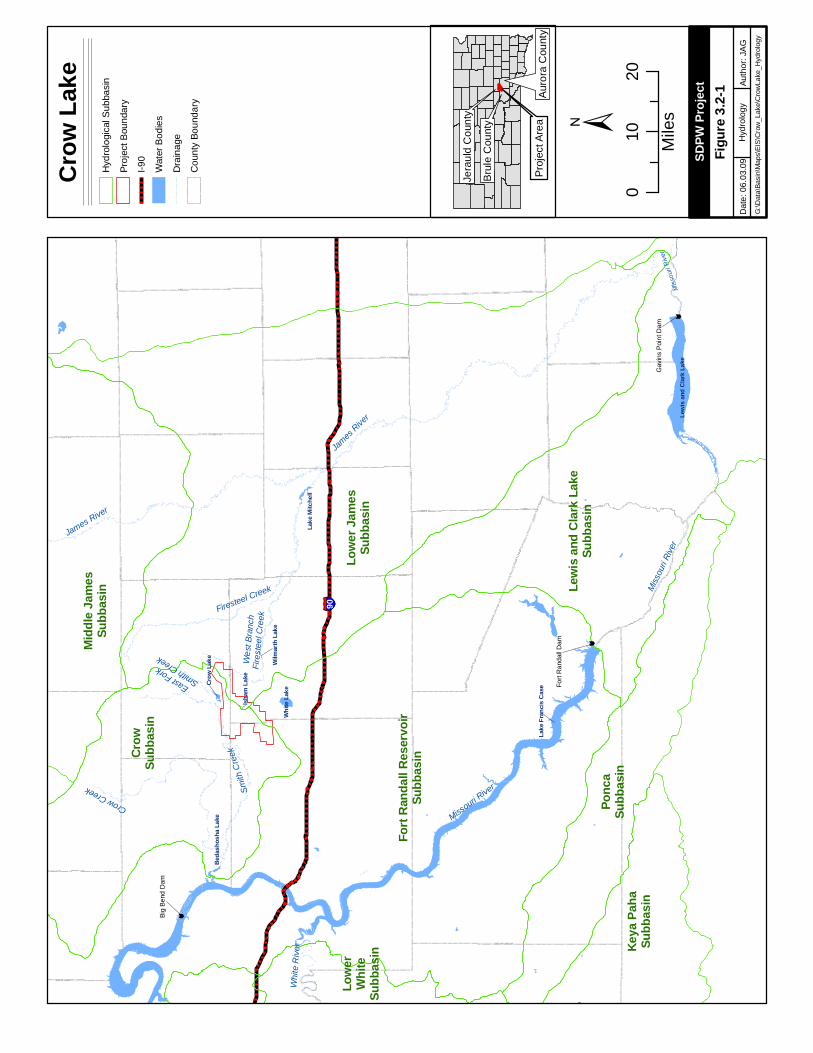
As depicted in Figure 3.2-1, drainage from the majority of the Crow Lake Alternative flows into the Missouri-White Subregion of the Missouri Region. A portion of the site along the north half of the eastern site boundary drains easterly toward the James Subregion of the Missouri Region.
Within the Missouri-White Subregion, the site falls into the Fort Randall Reservoir Basin and spans two subbasins:
DOE/EIS-0418, Draft 56 December 2009
Fort
Ran
dall
Dam
Gav
ins
Poi
nt D
am
Û
Û
Big
Ben
d D
am
Û
James R
iver
Crow
Lake Wi
lmart
h Lak
e
White
Rive
r
§̈¦90
Lake
Fran
cis C
ase
Rahn
Lake
Lewi
s and
Clar
k Lak
e
White
Lake
Lake
Mitc
hell
Beda
shos
ha La
ke
Isham
Lake
James River
Smith
Cree
k
Firesteel Creek
Missouri River
Misso
uri Ri
ver
Miss
ouri R
iver
Crow Creek
East ForkSmith Creek We
st Br
anch
Fires
teel C
reek
Lowe
r Jam
esSu
bbas
in
Fort
Rand
all R
eserv
oirSu
bbas
inCrow
Subb
asin
Lewi
s and
Clar
k Lak
eSu
bbas
inPo
nca
Subb
asin
Midd
le Ja
mes
Subb
asin
Keya
Paha
Subb
asin
Lowe
rWh
iteSu
bbas
in
±
Crow
Lake
Hyd
rolo
gica
l Sub
basi
n
Proj
ect B
ound
ary
I-90
Wat
er B
odie
s
Dra
inag
e
Cou
nty
Boun
dary
010
20
Mile
s
Papa
go R
d
Figur
e 3.2-
1D
ate:
06.
03.0
9Au
thor
: JA
GG
:\Dat
a\Ba
sin\
Map
s\EI
S\C
row
_Lak
e\C
row
Lake
_Hyd
rolo
gy
SDPW
Proje
ct
Hyd
rolo
gy
Jera
uld
Cou
nty
Pro
ject
Are
aA
uror
a C
ount
y
Bru
le C
ount
y
Chapter 3 South Dakota PrairieWinds Project
• The Crow Subbasin dominates the surface water drainage on the western and northwestern portions of the site
• The Fort Randall Reservoir Subbasin drains the southeastern portion of the site
Within the James Subregion:
• The Lower James Subbasin drains an eastern portion of the site
The Crow Subbasin
The majority of the Crow Lake Alternative lies within the Crow Subbasin. The East Fork of Smith Creek flows westerly into Crow Creek along the northern boundary of the site. Downstream of Crow Lake, East Fork Smith Creek converges into Smith Creek. Sayles Creek also begins within the northwestern portion of the site and flows into Smith Creek just west of the project boundary. Smith Creek continues westerly until the confluence with Crow Creek. Headwaters to these creeks originate within the site boundaries. Crow Creek used to flow into the man-made reservoir which formed Bedashosha Lake. Water was drained from the Bedashosha Lake impoundment, and the spillway and abutment walls were removed between 1995 and 2000. Crow Creek was restored to its natural elevation and currently flows through the lake bed and discharges to the Lake Francis Case portion of the Missouri River, just downstream of the Big Bend Dam (DENR 2009). No impaired waters lie downstream of the Crow Lake Alternative within this subbasin.
The Fort Randall Reservoir Subbasin
A small portion of the southeastern corner of the Crow Lake Alternative drains to the southeast in the Fort Randall Reservoir Subbasin. One unnamed stream drains Isham Lake, located within the site, and directs flows toward White Lake. White Lake is in this hydrologic subbasin, but does not have an outflow. No impaired waters lie downstream of the Crow Lake Alternative within this subbasin.
The Lower James Subbasin
The northeastern corner of the Crow Lake Alternative includes unnamed tributaries to the West Branch of Firesteel Creek. A dam was constructed along the West Branch to form Wilmarth Lake in 1936. Outflows exit over the spillway, and flow continues easterly to the convergence with Firesteel Creek. Firesteel Creek continues to flows eastward through Lake Mitchell and then into the James River at Mitchell, South Dakota. The James River flows south-southeast into the Missouri River downstream of the Gavins Point Dam at Yankton, South Dakota, outside of the ROI.
Substantial organic loading from nonpoint sources occur throughout the James River watershed during storm events (DENR 2008). Decay of organic matter contributes to low dissolved oxygen and degraded trophic state index. Agricultural activities such as livestock operations, grazing in riparian zones, lack of riparian vegetation, and row crop production contribute to the amount of
DOE/EIS-0418, Draft 58 December 2009
South Dakota PrairieWinds Project Chapter 3
suspended sediments and fecal coliforms in the basin. Wilmarth Lake, Firesteel Creek and segments of the James River are listed as impaired waters under Section 303(d) of the CWA.
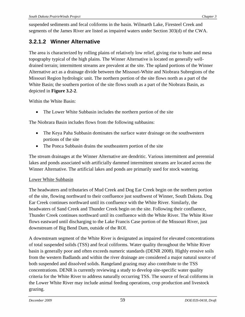
3.2.1.2 Winner Alternative
The area is characterized by rolling plains of relatively low relief, giving rise to butte and mesa topography typical of the high plains. The Winner Alternative is located on generally well-drained terrain; intermittent streams are prevalent at the site. The upland portions of the Winner Alternative act as a drainage divide between the Missouri-White and Niobrara Subregions of the Missouri Region hydrologic unit. The northern portion of the site flows north as a part of the White Basin; the southern portion of the site flows south as a part of the Niobrara Basin, as depicted in Figure 3.2-2.
Within the White Basin:
• The Lower White Subbasin includes the northern portion of the site
The Niobrara Basin includes flows from the following subbasins:
• The Keya Paha Subbasin dominates the surface water drainage on the southwestern portions of the site
• The Ponca Subbasin drains the southeastern portion of the site
The stream drainages at the Winner Alternative are dendritic. Various intermittent and perennial lakes and ponds associated with artificially dammed intermittent streams are located across the Winner Alternative. The artificial lakes and ponds are primarily used for stock watering.
Lower White Subbasin
The headwaters and tributaries of Mud Creek and Dog Ear Creek begin on the northern portion of the site, flowing northward to their confluence just southwest of Winner, South Dakota. Dog Ear Creek continues northward until its confluence with the White River. Similarly, the headwaters of Sand Creek and Thunder Creek begin on the site. Following their confluence, Thunder Creek continues northward until its confluence with the White River. The White River flows eastward until discharging to the Lake Francis Case portion of the Missouri River, just downstream of Big Bend Dam, outside of the ROI.
A downstream segment of the White River is designated as impaired for elevated concentrations of total suspended solids (TSS) and fecal coliforms. Water quality throughout the White River basin is generally poor and often exceeds numeric standards (DENR 2008). Highly erosive soils from the western Badlands and within the river drainage are considered a major natural source of both suspended and dissolved solids. Rangeland grazing may also contribute to the TSS concentrations. DENR is currently reviewing a study to develop site-specific water quality criteria for the White River to address naturally occurring TSS. The source of fecal coliforms in the Lower White River may include animal feeding operations, crop production and livestock grazing.
December 2009 59 DOE/EIS-0418, Draft
Chapter 3 South Dakota PrairieWinds Project
Keya Paha Subbasin
The headwaters of an unnamed tributary to the Keya Paha River flow southward from the southern portion of the site, through Rahn Lake and continue southward to its confluence with the Keya Paha River. The Keya Paha River flows generally southeasterly across the South Dakota State line into Nebraska where it drains into the Niobrara River. The Niobrara River flows generally east-southeastward and drains into the Missouri River at Niobrara, Nebraska, downstream of the Fort Randall Dam and above Lewis & Clark Lake, outside of the ROI.
Rahn Lake is impaired for trophic state index due to nutrient enrichment and siltation related to agricultural activities. The Keya Paha River is impacted by fecal coliforms and TSS; sources of fecal coliforms likely include grazing in rangeland, riparian areas and/or along shorelines. TSS is thought to originate from natural sources. The Niobrara River is listed as impaired by the State of Nebraska for Escherichia coli (E. coli) contamination. Point sources have been identified and include municipal wastewater treatment facilities, fish hatchery/rearing facilities and confined animal feeding operations. Nonpoint sources may also contribute E. coli, including failing septic tanks, runoff from livestock pastures, improper or over-application of biosolids (wastewater treatment facility sludge, septage or manure) and urban storm water runoff not regulated by a NPDES permit. Wildlife may also contribute E. coli to the river (EPA 2005).
Ponca Subbasin
The eastern portion of the Winner site contains the unnamed headwaters to Ponca Creek, generally draining to the east and northeast. One tributary is dammed to form Roosevelt Lake near the eastern extreme of the site. The spillway from Roosevelt Lake directs flow northward to Ponca Creek. Ponca Creek flows east and southeast across the South Dakota State line into Nebraska, generally paralleling the Keya Paha River. Ponca Creek continues southeastward and drains into the Missouri River just upstream of the confluence of the Niobrara and Missouri rivers, outside of the ROI.
Roosevelt Lake has exhibited high concentrations of mercury, and is listed as impaired. The source of the mercury contamination is unknown. Assessment of the lake is included in the Lewis and Clark Watershed Assessment, which is ongoing by Randall Resource Conservation and Development and DENR. Ponca Creek has reported elevated concentrations of TSS and fecal coliforms, and is also impaired. Agricultural activities such as livestock operations, grazing in riparian zones, lack of riparian vegetation and row crop production likely contribute to the amount of suspended sediments and fecal coliforms in Ponca Creek.
3.2.2 FLOODPLAINS
This DEIS evaluates mapped floodplains within the alternative site boundaries to identify areas that may be subject to flooding.
DOE/EIS-0418, Draft 60 December 2009
Fort
Ran
dall
Dam Û
§̈ ¦90
Lake
Fran
cis C
ase
Roos
evelt
Lake
Rahn
Lake
Ponca
Creek
White
Rive
r Dog Ear Creek
Thunder Creek
Keya
Paha
Rive
r
Missouri R
iver
Mud Creek
Sand Cree
k
Mud Creek
Sand Creek
Sand Creek Sand CreekMisso
uri River
South
Fork
Whe
tston
e Cree
k
Fort
Rand
all R
eserv
oirSu
bbas
in
Lowe
r Whit
eSu
bbas
in
Crow
Subb
asin
Keya
Paha
Subb
asin
Ponc
aSu
bbas
in
Medic
ineSu
bbas
in
Lowe
r Jam
esSu
bbas
in
Lewi
s and
Clar
k Lak
eSu
bbas
in
±
Winn
erH
ydro
logi
cal S
ubba
sin
Proj
ect B
ound
ary
I-90
Wat
er B
odie
s
Cou
nty
Boun
dary
Dra
inag
e
07.
515
Mile
s
Papa
go R
d
Figur
e 3.2-
2D
ate:
06.
03.0
9Au
thor
: JA
GG
:\Dat
a\Ba
sin\
Map
s\EI
S\W
inne
r\Win
ner_
Wat
er
SDPW
Proje
ct
Hyd
rolo
gy
Trip
p C
ount
y
Pro
ject
Are
a
Chapter 3 South Dakota PrairieWinds Project
3.2.2.1 Crow Lake Alternative
The Federal Emergency Management Agency (FEMA) has not mapped flood hazards in the unincorporated areas of Brule and Jerauld counties; flood insurance rate map (FIRM) panels are not available for review. Aurora County has been mapped and is designated as a flood hazard Zone D on the FIRM panel. A flood hazard Zone D is described as follows:
Areas with possible but undetermined flood hazards. No flood hazard analysis has been conducted. Flood insurance rates are commensurate with the uncertainty of the flood risk.
3.2.2.2 Winner Alternative
Floodplains and flood hazards in the unincorporated areas of Tripp County are largely unmapped by FEMA. The cities of Winner and Colome (southeast of Winner) have FIRM panels available. No flood hazard zones are mapped within Winner, and Colome has a strip of land running parallel to U.S. Highway 18 designated as a flood hazard Zone A. Zone A flood hazards are described as follows:
Areas with a 1% annual chance of flooding and a 26% chance of flooding over the life of a 30-year mortgage. Because detailed analyses are not performed for such areas; no depths or base flood elevations are shown within these zones.
3.2.3 GROUNDWATER RESOURCES
This DEIS characterizes groundwater resources underlying the alternative site boundaries. Where site specific data is limited, the configuration of the groundwater resources in the region is provided.
3.2.3.1 Crow Lake Alternative
The primary aquifers underlying the Crow Lake Alternative are associated with the regional, Northern Great Plains aquifer system. Small, localized and shallow aquifers within the near-surface shale deposits and glacial sediments can also produce groundwater (Terracon 2009a).
The regional aquifer can be anticipated at depths of approximately 900 to 1,250 feet below ground surface (bgs) and is separated from the near-surface glacial sediments by a confining unit associated with portions of the Pierre Shale formation. The groundwater flow direction in the regional aquifer is generally east-northeast (Terracon 2009a).
Many private wells within the Crow Lake Alternative have been advanced in the shallow, localized sand and gravel aquifers associated with Pleistocene glacial deposits. Water encountered in sands and gravels within 200 feet bgs are classified by the USGS as the Crow Lake local aquifers. Water levels reported for the Crow Lake local aquifers ranged from 1.9 to 100 feet bgs. The Crow Lake local aquifer has approximately 190,000 acre-feet of water in storage in Aurora and Jerauld counties and underlies approximately 50 square miles; the aquifer exhibits a strong correlation between precipitation events and groundwater levels (Terracon
DOE/EIS-0418, Draft 62 December 2009
South Dakota PrairieWinds Project Chapter 3
2009a). Locally, the uppermost and highly weathered/fractured beds of the Pierre Shale also can yield groundwater to support domestic uses (Terracon 2009a).
3.2.3.2 Winner Alternative
The Winner Alternative is located within an area of south-central South Dakota where the Northern Great Plains and High Plains regional aquifer systems overlap (Terracon 2009b). Groundwater at the site is primarily obtained from the unconsolidated deposits associated with the High Plains aquifer system. Depths to near-surface groundwater at the Winner site were within 50 feet bgs in the majority of the well records. Well depths generally ranged from 28 to 260 feet bgs, and six wells indicated groundwater levels at or near the ground surface (Terracon 2009b).
The near-surface permeable sediments allow direct infiltration of precipitation, recharge to the aquifer and seepage though the beds of streams over the majority of the site. Recharge is rapid where the surficial material consists of poorly consolidated sand, stream-valley deposits of sand and gravel or highly weathered sediments. Recharge is slower where sandstone or local beds of fine grained sediments are at the ground surface. Near the northeastern boundary of the site, near-surface deposits of the Pierre Shale sediments are not as readily permeable (Terracon 2009b).
3.2.4 WETLANDS AND WATERS OF THE UNITED STATES
The Proposed Project area is within the prairie pothole region, as designated by the USFWS. Wetlands, or prairie potholes, are scattered across the landscape throughout much of eastern and south-central South Dakota. Ranging from small lakes to temporary wetlands, these areas perform several important functions, including:
• flood control • groundwater recharge • water quality protection • plant, aquatic and wildlife habitat production
Under Section 404 of the CWA, the USACE has authority to regulate the discharge of dredged and fill material into WUS. WUS include traditional navigable waters and their non-navigable tributaries that typically flow year-round or have flow at least seasonally (e.g., typically three months).
Wetlands, which are special aquatic sites, can be jurisdictional under Section 404 as a subset of WUS. Wetlands, as defined by the EPA and the USACE in the Wetland Delineation Manual (Environmental Laboratory 1987), are “those areas that are inundated or saturated by surface or groundwater at a frequency and duration to support, and that under normal circumstances do support, a prevalence of vegetation typically adapted for life in saturated soil conditions.” The USACE will assert jurisdiction over wetlands adjacent to navigable waters and wetlands that directly abut their non-navigable tributaries.
December 2009 63 DOE/EIS-0418, Draft
Chapter 3 South Dakota PrairieWinds Project
National Wetlands Inventory (NWI) maps, produced by the USFWS and microfilmed by the USGS, provide a cursory evaluation of potential wetland areas. NWI maps are prepared primarily by stereoscopic analysis of high altitude aerial photographs. Potential wetland areas are noted based on vegetation, visible hydrology and geography. Generally, water bodies visible on the high altitude aerial photographs would be designated by the USFWS as “potential” wetland areas. Additionally, field investigations for site characterization in 2008 and 2009 (see Section 3.4) identified wetlands as part of the review of biological resources and land uses.
The USFWS has been acquiring conservation easements in the vicinity of the Proposed Project alternatives to support the preservation of grasslands and wetlands habitat. These conservation easements are further discussed in Sections 3.4 and 3.6.3.
3.2.4.1 Crow Lake Alternative
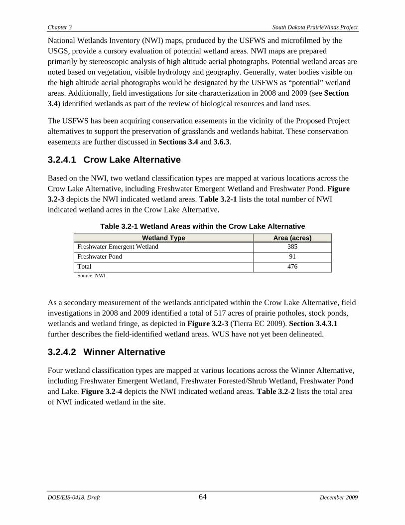
Based on the NWI, two wetland classification types are mapped at various locations across the Crow Lake Alternative, including Freshwater Emergent Wetland and Freshwater Pond. Figure 3.2-3 depicts the NWI indicated wetland areas. Table 3.2-1 lists the total number of NWI indicated wetland acres in the Crow Lake Alternative.
Table 3.2-1 Wetland Areas within the Crow Lake Alternative Wetland Type Area (acres)
Freshwater Emergent Wetland 385 Freshwater Pond 91 Total 476 Source: NWI
As a secondary measurement of the wetlands anticipated within the Crow Lake Alternative, field investigations in 2008 and 2009 identified a total of 517 acres of prairie potholes, stock ponds, wetlands and wetland fringe, as depicted in Figure 3.2-3 (Tierra EC 2009). Section 3.4.3.1 further describes the field-identified wetland areas. WUS have not yet been delineated.
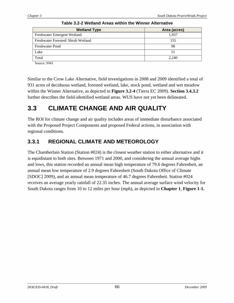
3.2.4.2 Winner Alternative
Four wetland classification types are mapped at various locations across the Winner Alternative, including Freshwater Emergent Wetland, Freshwater Forested/Shrub Wetland, Freshwater Pond and Lake. Figure 3.2-4 depicts the NWI indicated wetland areas. Table 3.2-2 lists the total area of NWI indicated wetland in the site.
DOE/EIS-0418, Draft 64 December 2009
Proj
ect B
ound
ary
Tow
nshi
p an
d R
ange
Sect
ion
!!
Wes
tern
Util
ity L
ine
! (Tu
rbin
e
Col
lect
or S
yste
m
Inte
rnal
Roa
d
Subs
tatio
n
O&
M B
uild
ing
Overh
ead T
ransm
ission
Line
!!
Alte
rnat
ive
1!
!Al
tern
ativ
e 2
!!
Alte
rnat
ive
3
Wat
er B
odie
s
Fiel
d Ve
rifie
d W
etla
nd
Dra
inag
e
Natio
nal W
etlan
d Inv
entor
yFr
eshw
ater
Em
erge
nt W
etla
nd
Fres
hwat
er P
ond
!(
!(
!(
!(
!(
!(
!(
!(
!(
!(
!(
!(
!(
!(
!(
!(
!(
!(
!(
!(
!(
!(
!(
!(
!(
!(
!(
!(
!(
!(
!(
!(
!(
!(
!(
!(
!(
!(
!(
!(
!(
!(
!(
!(
!(
!(
!(
!(
!(
!(
!(
!(
!(
!(
!(
!(
!(
!(
!(
!(
!(
!(
!(
!(
!(
!(
!(
!(
!(
!(
!(
!(!(
!(
!(
!(
!(
!(
!(
!(
!(
!(
!(
!(
!(
!(
!(
!(
!(
!(
!(
!(
!(
!(
!(
!(
!(
!(
!(
!(
!(
!(
!(
!(
!(
!(
!(
!(
!(
!(
!(
!!
!
!!
!
!
!
!
!
!
!
!
!
!
!
!!
!!
!!
!!
!!
!!
!!
!!
!!
!!
!!
!!
!!
!!
!!
!!
!!
!!
!!
!!
!!
!
!!
!!
!!
!!
!!
!
!!
!!
!!
!!
!!
!!
!
!
!
!
!
!
!
!
!
!
!
!
!
!
!
!
!
!
!
!
!
!
!
!
!
!
!
!
!
!
!
!
!
!
!
!
!
!
!
!
!
!
!
!
!
!
!
!
!
!
!
!
!
!
!
!
!
!
!
!
!
!
!
!
!
!
!
!
!
!
!
!
!
!
!
!
!
!
!
!
!
!
!
!
!
!
!
!
!
!
!
!
!
!
!
!
!
!
!
!
!
!
!
!
!
!
!
!
!
!
!
!
!
!
!
!
!
!
!
!
!
!
!
!
!
!
!
!
!
!
!
!
!
!
!
!
!
!
!
!
!
!
!
!
!
!
!
!
!
!
!
!
!
!
!
!
!
!
!
!
!
!
!
!
!
!
!
!
!
!
!
!
!
!
!
!
!
!
!
!
!
!
!
!
!
!
!
!
!
!
!
!
!
!
!
!
!
!
!
!
!
!
!
!
!
!
!
!
!
!
!
!
!
!
!
!
!
!
!
!
!
!
!
!
!
!
!
!
!
!
!
!
!
!
!
!
!
!
!
!
!
!
!
!!
!
!
!
!!
!
!
!
!
!
!
!
!
!
!
!
!
!
!
!
!
!
!
!
!
!
!
!
!
!
!
!
!
!
!
!
!
!
!
!
!
!!!
!!
!!
!!
!!
!!
!!
!!
!
!!!
!!
!!
!!
!!
!
!!!!
!
!!
!!
!!
!!
!!!
!
!!
!!
!!
!!!!
!!
!!!
Isham
Lake
White
Lake
West Br
anch
Fireste
el Cree
k
Smith
Cree
kCr
ow La
ke
±
Crow
Lake
01
23
Mile
s
Papa
go R
dD
ate:
06.
03.0
9Au
thor
: JA
GG
:\Dat
a\Ba
sin\
Map
s\EI
S\W
inne
r\Cro
w_L
ake_
Wat
er
SDPW
Proje
ct
Wat
er
Jera
uld
Cou
nty
Pro
ject
Are
aA
uror
a C
ount
y
Bru
le C
ount
y
R67WR66W
R66WR65WT1
04N
T105
N
T105
NT1
06N
Figur
e 3.2-
3
Due
to e
ngin
eerin
g co
nsid
erat
ions
, the
tran
smis
sion
line
Alte
rnat
ive
1 lo
catio
n in
clud
es a
rea
outs
ide
of th
e C
row
Lak
e A
ltern
ativ
e bo
unda
ry;
this
bou
ndar
y w
ill b
e re
vise
d to
incl
ude
the
trans
mis
sion
line
rout
e in
the
FEIS
.
Chapter 3 South Dakota PrairieWinds Project
Table 3.2-2 Wetland Areas within the Winner Alternative Wetland Type Area (acres)
Freshwater Emergent Wetland 1,937 Freshwater Forested/ Shrub Wetland 155 Freshwater Pond 98 Lake 51 Total 2,240 Source: NWI
Similar to the Crow Lake Alternative, field investigations in 2008 and 2009 identified a total of 931 acres of deciduous wetland, forested wetland, lake, stock pond, wetland and wet meadow within the Winner Alternative, as depicted in Figure 3.2-4 (Tierra EC 2009). Section 3.4.3.2 further describes the field-identified wetland areas. WUS have not yet been delineated.
3.3 CLIMATE CHANGE AND AIR QUALITY The ROI for climate change and air quality includes areas of immediate disturbance associated with the Proposed Project Components and proposed Federal actions, in association with regional conditions.
3.3.1 REGIONAL CLIMATE AND METEOROLOGY
The Chamberlain Station (Station #024) is the closest weather station to either alternative and it is equidistant to both sites. Between 1971 and 2000, and considering the annual average highs and lows, this station recorded an annual mean high temperature of 79.6 degrees Fahrenheit, an annual mean low temperature of 2.9 degrees Fahrenheit (South Dakota Office of Climate [SDOC] 2009), and an annual mean temperature of 46.7 degrees Fahrenheit. Station #024 receives an average yearly rainfall of 22.35 inches. The annual average surface wind velocity for South Dakota ranges from 10 to 12 miles per hour (mph), as depicted in Chapter 1, Figure 1-1.
DOE/EIS-0418, Draft 66 December 2009
!!
!!
!!
!!
!!
!!
!!
!!
!!
!!
!!
!
!
!
!
!
!
!
!
!
!
!
!
!
!
!
!
!!
!!
!!
!!
!!
!!
!!
!!
!!
!
!
!
!
!
!
!
!
!
!
!
!
!
!
!
!
!
!
!
!
!
!
!
!
!!
!!
!!
!!
!!
!!
!!
!!
!!
!!
!!
!!
!!
!!
!!
!!
!
!!
!
!!!!!!!!!!!!
!
!
!!!!!!!!!
!(
!(
!(
!(
!(
!(!(
!(!(
!(!(
!(
!( !(
!(
!(
!(
!(
!(
!(
!(
!(
!(
!(
!(
!(
!(
!(!(
!(!(
!(
!(
!(
!(!(
!(
!(
!(
!(
!(
!(
!(
!(
!(
!(
!( !(
!(
!(
!(
!( !(
!(
!(
!(
!(
!(
!(
!(
!(
!(
!(
!(
!(
!(
!(
!(
!(
!(
!(
!(
!(
!(
!(
!(
!(
!(
!(
!(
!(
!(
!(
!(!(
!(
!(
!(
!(
!(
!(
!(
!(
!(
!(!(
!(
!(
!(
!(
!(
!(
!(
!(
!(
!(
!(
!(!(
!(
!(
¬«44
£ ¤18
£ ¤183
Roos
evelt
Lake
±
Winn
erPr
ojec
t Bou
ndar
y
Tow
nshi
p an
d R
ange
Sect
ion
!!
Wes
tern
Util
ity L
ine
Sta
te/U
S H
ighw
ay
Subs
tatio
n an
d O
&M
Bui
ldin
g
!(Tu
rbin
e
Col
lect
or S
yste
m
Inte
rnal
Roa
d
Overh
ead T
rans
miss
ion Li
ne!
!A
ltern
ativ
e 1
!!
Alte
rnat
ive
2
Fiel
d Ve
rifie
d W
etla
nd
Dra
inag
e
Wat
er B
odie
s
Natio
nal W
etlan
d Inv
entor
yFr
eshw
ater
Em
erge
nt W
etla
nd
Fres
hwat
er F
ores
ted/
Shr
ub W
etla
nd
Fres
hwat
er P
ond
Lake
02.
55
Mile
s
Papa
go R
dD
ate:
06.
03.0
9Au
thor
: JA
GG
:\Dat
a\Ba
sin\
Map
s\EI
S\W
inne
r\Win
ner_
Wat
er
SDPW
Proje
ct
Wat
er
Trip
p C
ount
y
Pro
ject
Are
a
Figur
e 3.2-
4
R77WR76W
R76WR75W
T966
NT9
7N
T98N
T99N
R78WR77W
R75WR74W
T97N
T98N
Chapter 3 South Dakota PrairieWinds Project
3.3.2 AIR POLLUTANTS
Air quality in South Dakota is regulated by the DENR Air Quality Program, which is responsible for permitting and enforcement. Federal and State laws seek to reduce air pollution to levels shown by research to protect the majority of individuals and reduce overall impacts to ecosystems. The implementation of these laws begins with setting air quality standards, which describe the existing air environment in the Proposed Project area. The EPA sets NAAQS to regulate the emissions of six air pollutants referred to as “criteria pollutants.” DENR has adopted the NAAQS for the State air quality program. The criteria pollutants include:
• Carbon monoxide (CO) • Lead (Pb) • Nitrogen dioxide (NO2) • Ozone (O3) • Particulate matter less than 10 (PM10) and 2.5 (PM2.5) microns in diameter • Sulfur dioxide (SO2)
3.3.3 AMBIENT AIR QUALITY
Both the Crow Lake and Winner alternatives are in attainment for the NAAQS, thus no special mitigation measures are required for new activities.
3.3.4 CLIMATE CHANGE
Carbon dioxide (CO2) is one of six greenhouse gases (GHGs) that contributes to climate change. CO2 emissions represent approximately 84 percent of all GHG emissions in the U.S. CO2 is generated whenever a carbon-based fuel, such as coal, wood, natural gas, or fuel oil is burned. It is the primary GHG emitted from fossil-fired utility boilers, with approximately 41 percent of U.S. carbon emissions (primarily CO2) coming from power plant sources (Energy Information Administration [EIA] 2009). Other significant sources are automobile and truck exhaust, industrial combustion sources and residential heating sources. Wind-generating stations do not emit CO2.
Within South Dakota, CO2 emissions resulting from fossil fuel combustion totaled 13.78 million tons in 2007 (EPA 2009a). Five principal sectors contribute to CO2 emissions through the combustion of fossil fuels, including commercial, industrial, residential, transportation and electric power. Of these, activities related to the generation of electric power accounted for 2.96 million tons of CO2 emitted in South Dakota (EPA 2009a).
In addition to CO2, sulfur hexafluoride (SF6) is another GHG listed by the Intergovernmental Panel on Climate Change (IPCC). Western’s existing substations in the Proposed Project areas use SF6, a gaseous dielectric, used in high-voltage circuit breakers, switchgears and other electrical equipment, such as circuit breakers. Since 2000, Western has had an aggressive program to identify and repair leaks throughout the transmission system to reduce SF6 emissions. Project personnel would monitor the use, storage and replacement of SF6 to minimize
DOE/EIS-0418, Draft 68 December 2009
South Dakota PrairieWinds Project Chapter 3
any releases to the environment. The likelihood for accidental release is low, as SF6 gas is supplied in sealed units and is factory-certified not to leak. The activities associated with Western’s proposed Federal action would be done in accordance with Western's environmental protection provisions.
Wind farms and substations do not emit substantial amounts of the other GHGs.
3.4 BIOLOGICAL RESOURCES 3.4.1 REGULATORY FRAMEWORK
3.4.1.1 Federal Statutes
Endangered Species Act
The ESA provides for the conservation of threatened and endangered plants and animals and the habitats in which they are found. The ESA is implemented by two Federal agencies, the USFWS and National Oceanic and Atmospheric Administration Fisheries (NOAA Fisheries), which are authorized to list plant and animal species as endangered, threatened or candidates for listing. Section 7 of the ESA imposes an affirmative duty on Federal agencies to ensure that their actions (including permitting) are not likely to jeopardize the continued existence of a listed species or result in the destruction or modification of its habitat.
Migratory Bird Treaty Act
The MBTA makes it illegal for anyone to “pursue, hunt, take, capture, kill, attempt to take, capture or kill, possess, offer for sale, sell, offer to purchase, purchase, deliver for shipment, ship, cause to be shipped, deliver for transportation, transport, cause to be transported, carry, or cause to be carried by any means whatever, receive for shipment, transportation or carriage, or export, at any time, or in any manner, any migratory bird. . . or any part, nest, or egg of any such bird” (16 U.S.C. 703).
Bald and Golden Eagle Protection Act
The BGEPA (16 U.S.C. 668-668c) prohibits anyone, without a permit issued by the Secretary of the Interior, from "taking" Bald Eagles, including their parts, nests or eggs. The BGEPA provides criminal penalties for persons who "take, possess, sell, purchase, barter, offer to sell, purchase or barter, transport, export or import, at any time or any manner, any bald eagle ... [or any golden eagle], alive or dead, or any part, nest, or egg thereof." The BGEPA defines "take" as "pursue, shoot, shoot at, poison, wound, kill, capture, trap, collect, molest or disturb."
December 2009 69 DOE/EIS-0418, Draft
Chapter 3 South Dakota PrairieWinds Project
3.4.1.2 State Statutes
South Dakota Wildlife Diversity Program
The South Dakota Wildlife Diversity Program (South Dakota Codified Laws [SDCL] 34A-2-1, 38-7-1) protects species and habitats that comprise the biological diversity of the State “in a manner that meets the needs and desires of the citizens of the State.” Statutory policies are geared toward the conservation of water and soils to help preserve wildlife. The SDGFP maintains the interagency South Dakota Natural Heritage Program (SDNHP) to track species lists for the State.
South Dakota Endangered Species Law
The South Dakota Endangered Species Law (SDCL Ann. 34A-8-1 et seq.) covers animals and plants. Listings are based on scientific, commercial and other data. The law does not require recovery plans, critical habitat designation or agency consultation.
3.4.2 STUDY METHODS
The ROI for biological resources is different for vegetation and wildlife. The ROI for vegetation includes areas of direct disturbance (temporary and permanent) associated with the Proposed Project Components. The ROI for wildlife includes all areas within the boundaries, because the Proposed Project could impact wildlife species in areas that extend beyond the footprint for construction (including temporary and permanent disturbance areas) of the Proposed Project Components. This includes lands adjacent to proposed facilities but within the boundaries that are used by wildlife, such as migration corridors.
Biological data was collected from literature searches; agency personnel and reports from USFWS, SDGFP and the SDNHP; ecological reports and databases (e.g., NatureServe, GAP analysis); and field investigations. Biologists from Western, Tierra EC, Western EcoSystems Technology, Inc. (WEST) and Terracon provided regional and site-specific information for biological resources. USFWS correspondence provided input during the Proposed Project scoping (Appendix C). Information for Federally-listed species was requested from the USFWS on October 14, 2009; a response was provided on November 12, 2009 (Appendix C).
Field investigations were conducted for site characterization in July, September, October and November 2008, and March through July 2009. WEST conducted grouse lek surveys, breeding bird surveys, migratory bird surveys and bat use surveys during the spring and summer of 2009. WEST continued to conduct avian use surveys (until November 2009) and bat use surveys (through October 2009). WEST provided interim survey reports in August 2009, including data for analysis in this DEIS. In addition to the avian and bat use surveys, a PII study (see Sections 4.4.3.1 and 4.4.3.2, Wildlife, Birds) was completed to evaluate potential impacts to biological resources in accordance with the USFWS’s Interim Guidelines on Assessing Wind Impacts to Wildlife (USFWS 2003). Where feasible, site development, turbine design and operational recommendations were incorporated into the project design, as described in Chapter 2.
DOE/EIS-0418, Draft 70 December 2009
South Dakota PrairieWinds Project Chapter 3
3.4.3 VEGETATION COMMUNITIES
3.4.3.1 Crow Lake Alternative
Regional Overview
The Crow Lake Alternative is within the Southern Missouri Coteau subregion of the Northern Glaciated Plains Ecoregion (Bryce et al. 1998; Omernik 2005). Bailey et al. (1995) describe this area as the Eastern Prairie Ecoregion, Mixedgrass Subregion. This region is characterized by elevation ranges of 1,985 to 2,510 feet AMSL. The area is mesic with average annual precipitation in excess of 20 inches. Mixed grasses dominate the native vegetation. Species of wheatgrass (Agropyron spp.), needlegrass (Stipa spp.) and grama (Bouteloua spp.) are common, while woody vegetation is rare and generally limited to drainages. Cropland is also common and consists primarily of corn, small grains and alfalfa. Most of the area is nearly level to undulating glacial till plains with prairie pothole wetlands and moraines. Steep slopes are prevalent adjacent to the major streams. Wetland basin densities in the Prairie Pothole Region (PPR) are some of the highest in the country with densities as high as 83 wetland basins per square mile. The wetland basin density in the Crow Lake area is nine to 10 basins per square mile, some of the lower basin densities in the PPR (Kempema 2007).
Crow Lake Alternative Description
As detailed in Table 3.4-1 and Figure 3.4-1, the Crow Lake Alternative is composed of rolling hills intermixed with mixed-grass prairie, including rangeland, pastureland and Conservation Reserve Program (CRP)/prairie, cropland, wetlands (including stock ponds), farmsteads and patches of deciduous trees (mostly shelterbelts) (Tierra EC 2009). Elevations range from 1,644 feet AMSL in the bottomlands to 1,985 feet AMSL in the northwest portion of the site.
Table 3.4-1 Vegetation Communities in the Crow Lake Alternative
Vegetation Type Acres Percentage of Area
Mixed-grass prairie 23,007 64% Cropland 11,678 33% Wetlands 517 1% Farmstead 276 <1% Shelterbelt 261 <1% Deciduous forest 82 <1%
Mixed-grass Prairie (including rangeland, pastureland and CRP/prairie)
Mixed-grass prairie accounts for approximately 64 percent (23,007 acres) of the Crow Lake Alternative. Mixed-grass prairie includes rangeland (untilled areas, as well as areas that were tilled at one time but have reverted to grassland), pasture and CRP/prairie. There is very little unbroken sod in the area.
December 2009 71 DOE/EIS-0418, Draft

Chapter 3 South Dakota PrairieWinds Project
Rangeland (22,222 acres) includes areas of expansive, mostly unimproved land on which native or adapted, introduced plant species are managed for livestock grazing. Some areas contain unbroken sod; however, much of this acreage has been plowed at one time. Dominant herbaceous vegetation includes smooth brome (Bromus inermis) and sweet-clover (Melilotus spp.), with occasional occurrences of Carduus spp., Artemisia spp. and various members of the Asteraceae family. In addition to herbaceous plant species, rangeland often contains scattered plains cottonwood (Populus deltoides) and various shrub species.
Pasture (692 acres) includes areas where livestock are held in high densities. Herbaceous vegetation is often minimal; where present, the vegetation is often heavily grazed.
CRP/prairie (93 acres) is areas of naturally occurring prairie or planted grasslands where native prairie grasses are dominant. CRP includes areas of cropland that have been removed from crop production for a specific period (usually 10 years) and are planted with cover designed to conserve soil and water. Hay production and livestock grazing are not permitted on CRP land unless specifically allowed during droughts. The Farm Service Agency (FSA) handbook, updated by the USDA in May 2008, expressly forbids the FSA from revealing acreages or locations of CRP; therefore, this information is no longer available so an estimate of CRP lands within the Crow Lake Alternative cannot be made. Based on field observations, the majority of lands in the CRP/prairie category appear to be CRP (previously broken sod), and not naturally occurring prairie (unbroken sod). CRP/prairie is dominated by smooth brome (Bromus inermis), prairie beard grass (Schizachyrium scoparium), big blue-stem (Andropogon gerardii), switch grass (Panicum virgatum), Kentucky bluegrass (Poa pratensis) and sweet-clover (Melilotus spp.).
The USFWS has approximately 1,629 acres of grasslands in five parcels enrolled in the Grassland Easement program within the Crow Lake Alternative (USFWS 2008). Grassland Easements are included in the mixed-grass prairie land use category in Table 3.4-1. Figure 3.4-2 identifies the locations of the Grassland Easements within the area. Grasslands protected under easements are prevented from being permanently converted to cropland or development. Landowners may use the land within the easement for grazing and haying; however, mowing, haying and grass seed harvesting must be delayed until after July 15th of each year. The program allows one wind turbine with associated facilities per 160 acres enrolled. Locating turbines on Grassland Easements requires coordination with the USFWS.
Cropland
Cropland accounts for approximately 33 percent (11,678 acres) of the Crow Lake Alternative. It includes all open space areas where agricultural products are currently in production. This category was further divided into specific cover type classifications based on the previous year’s crop type (i.e., row crop or cover crop). Row crops include plantings such as sorghum or corn; cover crops include alfalfa, winter wheat or hay. Many agricultural lands alternate between row and cover crops. Some areas defined as cropland are also used as rangeland during parts of the year.
DOE/EIS-0418, Draft 72 December 2009
Proj
ect B
ound
ary
Tow
nshi
p an
d R
ange
Sect
ion
Dra
inag
e!
!W
este
rn U
tility
Lin
e
Subs
tatio
n
O&
M B
uild
ing
!(Tu
rbin
e
Col
lect
or S
yste
m
Inte
rnal
Roa
d
Overh
ead T
ransm
ission
Line
!!
Alte
rnat
ive
1!
!Al
tern
ativ
e 2
!!
Alte
rnat
ive
3
Habit
at Cro
plan
d
Dec
iduo
us F
ores
t
Farm
stea
d
Min
e/Q
uarr
y
Mix
ed-g
rass
Pra
irie
Shel
terb
elt
Wet
land
!!
!
!!
!
!
!
!
!
!
!
!
!
!
!
!!
!!
!!
!!
!!
!!
!!
!!
!!
!!
!!
!!
!!
!!
!!
!!
!!
!!
!!
!!
!!
!
!!
!!
!!
!!
!!
!
!!
!!
!!
!!
!!
!!
!
!
!
!
!
!
!
!
!
!
!
!
!
!
!
!
!
!
!
!
!
!
!
!
!
!
!
!
!
!
!
!
!
!
!
!
!
!
!
!
!
!
!
!
!
!
!
!
!
!
!
!
!
!
!
!
!
!
!
!
!
!
!
!
!
!
!
!
!
!
!
!
!
!
!
!
!
!
!
!
!
!
!
!
!
!
!
!
!
!
!
!
!
!
!
!
!
!
!
!
!
!
!
!
!
!
!
!
!
!
!
!
!
!
!
!
!
!
!
!
!
!
!
!
!
!
!
!
!
!
!
!
!
!
!
!
!
!
!
!
!
!
!
!
!
!
!
!
!
!
!
!
!
!
!
!
!
!
!
!
!
!
!
!
!
!
!
!
!
!
!
!
!
!
!
!
!
!
!
!
!
!
!
!
!
!
!
!
!
!
!
!
!
!
!
!
!
!
!
!
!
!
!
!
!
!
!
!
!
!
!
!
!
!
!
!
!
!
!
!
!
!
!
!
!
!
!
!
!
!
!
!
!
!
!
!
!
!
!
!
!
!
!
!!
!
!
!
!!
!
!
!
!
!
!
!
!
!
!
!
!
!
!
!
!
!
!
!
!
!
!
!
!
!
!
!
!
!
!
!
!
!
!
!
!
!!!
!!
!!
!!
!!
!!
!!
!!
!
!!!
!!
!!
!!
!!
!
!!!!
!
!!
!!
!!
!!
!!!
!
!!
!!
!!
!!!!
!!
!!!
! (
! (
! (
! (
! (
! (
! (
! (
! (
! (
! (
! (
! (
! (
! (
! (
! (
! (
! (
! (
! (
! (
! (
! (
! (
! (
! (
! (
! (
! (
! (
! (
! (
! (
! (
! (
! (
! (
! (
! (
! (
! (
! (
! (
! (
! (
! (
! (
! (
! (
! (
! (
! (
! (
! (
! (
! (
! (
! (
! (
! (
! (
! (
! (
! (
! (
! (
! (
! (
! (
! (
! (! (
! (
! (
! (
! (
! (
! (
! (
! (
! (
! (
! (
! (
! (
! (
! (
! (
! (
! (
! (
! (
! (
! (
! (
! (
! (
! (
! (
! (
! (
! (
! (
! (
! (
! (
! (
! (
! (
! (
±
Crow
Lake
01
23
Mile
s
Papa
go R
dD
ate:
06.
03.0
9Au
thor
: JA
GG
:\Dat
a\Ba
sin\
Map
s\EI
S\W
inne
r\Cro
w_L
ake_
Vege
tatio
n
SDPW
Proje
ct
Hab
itat
Jera
uld
Cou
nty
Pro
ject
Are
aA
uror
a C
ount
y
Bru
le C
ount
y
Figur
e 3.4-
1
R67WR66W
R66WR65WT1
04N
T105
N
T105
NT1
06N
Due
to e
ngin
eerin
g co
nsid
erat
ions
, the
tran
smis
sion
line
Alte
rnat
ive
1 lo
catio
n in
clud
es a
rea
outs
ide
of th
e C
row
Lak
e A
ltern
ativ
e bo
unda
ry;
this
bou
ndar
y w
ill b
e re
vise
d to
incl
ude
the
trans
mis
sion
line
rout
e in
the
FEIS
.
Chapter 3 South Dakota PrairieWinds Project
Wetlands (including stock ponds)
Wetlands account for slightly over one percent (517 acres) of the Crow Lake Alternative. Prairie potholes describe the naturally occurring depressional wetlands where native and non-native hydrophytic vegetation persists. Dominant vegetation includes prairie cord grass (Spartina pectinata), reed canary grass (Phalaris arundinacea), narrow-leaved cattail (Typha angustifolia) and river bulrush (Bolboschoenus fluviatilis).
Stock ponds are areas where ranchers have bermed natural drainage features or seasonal wetlands to create a persistent water supply for livestock. These areas are often heavily grazed and do not generally contain a perimeter of hydrophytic vegetation.
The USFWS has approximately 2,836 acres of wetlands and adjacent uplands in 15 parcels enrolled in the Wetland Easement program within the Crow Lake Alternative (USFWS 2008). Wetland Easement areas are not displayed in Table 3.4-1, but are accounted for in both the mixed-grass prairie and wetlands area estimates. They are not displayed as wetland easements because wetland easements include both habitat types and the data do not distinguish these acreages by parcel.
Farmstead, Shelterbelt and Deciduous Forest
Farmsteads account for less than one percent (276 acres) of the Crow Lake Alternative. Farmsteads include developed areas of land with various structures devoted to residential, commercial or industrial practices. These areas are adjacent to pasture or rangeland and are scattered throughout the site.
Shelterbelts account for less than one percent (261 acres) of the Crow Lake Alternative. Shelterbelts are trees or shrubs planted in one or more rows that provide shelter from wind or protect soil from erosion. Shelterbelts are typically found around the edges of fields, pastures and/or farmsteads. Most of the shelterbelts are associated with farmsteads. The most commonly observed tree species within the shelterbelts is eastern red cedar (Juniperus virginiana); plains cotton wood (Populus deltoides) and wild plum (Prunus americana) are also present.
Deciduous forest accounts for less than one percent of the Crow Lake Alternative. These are areas of dense, naturally occurring tree species. In upland areas, plains cottonwoods (Populus deltoides) are most abundant, with occurrences of eastern red-cedar (Juniperus virginiana), Siberian elm (Ulmus pumila), green ash (Fraxinus pennsylvanica) and wild plum (Prunus americana). Deciduous forest is often located as islands within rangeland.
Invasive and Noxious Plants
In South Dakota, invasive species include declared pests and noxious weeds. These are defined as species which the South Dakota Weed and Pest Control Commission has designated as sufficiently detrimental to the State to warrant enforcement of control measures (Administrative Rule [AR] 12:62:02:01). South Dakota has documented 27 invasive species under this rule.
DOE/EIS-0418, Draft 74 December 2009
!!
!
!!
!
!
!
!
!
!
!
!
!
!
!
!!
!!
!!
!!
!!
!!
!!
!!
!!
!!
!!
!!
!!
!!
!!
!!
!!
!!
!!
!!
!!
!
!!
!!
!!
!!
!!
!
!!
!!
!!
!!
!!
!!
!
!
!
!
!
!
!
!
!
!
!
!
!
!
!
!
!
!
!
!
!
!
!
!
!
!
!
!
!
!
!
!
!
!
!
!
!
!
!
!
!
!
!
!
!
!
!
!
!
!
!
!
!
!
!
!
!
!
!
!
!
!
!
!
!
!
!
!
!
!
!
!
!
!
!
!
!
!
!
!
!
!
!
!
!
!
!
!
!
!
!
!
!
!
!
!
!
!
!
!
!
!
!
!
!
!
!
!
!
!
!
!
!
!
!
!
!
!
!
!
!
!
!
!
!
!
!
!
!
!
!
!
!
!
!
!
!
!
!
!
!
!
!
!
!
!
!
!
!
!
!
!
!
!
!
!
!
!
!
!
!
!
!
!
!
!
!
!
!
!
!
!
!
!
!
!
!
!
!
!
!
!
!
!
!
!
!
!
!
!
!
!
!
!
!
!
!
!
!
!
!
!
!
!
!
!
!
!
!
!
!
!
!
!
!
!
!
!
!
!
!
!
!
!
!
!
!
!
!
!
!
!
!
!
!
!
!
!
!
!
!
!
!
!!
!
!
!
!!
!
!
!
!
!
!
!
!
!
!
!
!
!
!
!
!
!
!
!
!
!
!
!
!
!
!
!
!
!
!
!
!
!
!
!
!
!!!
!!
!!
!!
!!
!!
!!
!!
!
!!!
!!
!!
!!
!!
!
!!!!
!
!!
!!
!!
!!
!!!
!
!!
!!
!!
!!!!
! (
! (
! (
! (
! (
! (
! (
! (
! (
! (
! (
! (
! (
! (
! (
! (
! (
! (
! (
! (
! (
! (
! (
! (
! (
! (
! (
! (
! (
! (
! (
! (
! (
! (
! (
! (
! (
! (
! (
! (
! (
! (
! (
! (
! (
! (
! (
! (
! (
! (
! (
! (
! (
! (
! (
! (
! (
! (
! (
! (
! (
! (
! (
! (
! (
! (
! (
! (
! (
! (
! (
! (! (
! (
! (
! (
! (
! (
! (
! (
! (
! (
! (
! (
! (
! (
! (
! (
! (
! (
! (
! (
! (
! (
! (
! (
! (
! (
! (
! (
! (
! (
! (
! (
! (
! (
! (
! (
! (
! (
! (
!!
!!!
Blac
k Te
rn
±
Crow
Lake
Proj
ect B
ound
ary
Tow
nshi
p an
d R
ange
Sect
ion
!!
Wes
tern
Util
ity L
ine
!(Tu
rbin
e
Subs
tatio
n
O&
M B
uild
ing
Col
lect
or S
yste
m
Inte
rnal
Roa
d
Over
head
Tran
smiss
ion Li
ne!
!Al
tern
ativ
e 1
!!
Alte
rnat
ive
2!
!Al
tern
ativ
e 3
Nat
ural
Her
itage
Hab
itat
Dra
inag
e
Maj
or W
ater
Bod
ies
(EPA
)
Gam
e P
rodu
ctio
n A
rea
Wat
erfo
wl P
rodu
ctio
n A
rea
USFW
S Eas
emen
tsG
rass
land
Wet
land
01
23
Mile
s
Papa
go R
dD
ate:
06.
03.0
9Au
thor
: JA
G
G:\D
ata\
Basi
n\M
aps\
EIS
\Win
ner\C
row
_Lak
e_In
frast
ruct
ure
SDPW
Proje
ct
Con
serv
atio
nAr
eas
Jera
uld
Cou
nty
Pro
ject
Are
aA
uror
a C
ount
y
Bru
le C
ount
y
R67WR66W
R66WR65WT1
04N
T105
N
T105
NT1
06N
Figur
e 3.4-
2
Due
to e
ngin
eerin
g co
nsid
erat
ions
, the
tran
smis
sion
line
Alte
rnat
ive
1 lo
catio
n in
clud
es a
rea
outs
ide
of th
e C
row
Lak
e A
ltern
ativ
e bo
unda
ry;
this
bou
ndar
y w
ill b
e re
vise
d to
incl
ude
the
trans
mis
sion
line
rout
e in
the
FEIS
.
Chapter 3 South Dakota PrairieWinds Project
Table 3.4-2 South Dakota Invasive Plant Species Documented in Jerauld, Aurora or Brule Counties
Common Name Scientific Name
Absinth wormwood Artemisia absinthium Hoary cress Cardaria draba Plumeless thistle Carduus acanthoides Musk thistle Carduus nutans Russian knapweed Centaurea repens Canada thistle Cirsium arvense Field bindweed Convolvulus arvensis Leafy spurge Euphorbia esula Perennial sow thistle Sonchus arvensis Puncturevine Tribulus terrestris Common mullein Verbascum thapsus
Source: South Dakota Department of Agriculture 2008
Table 3.4-2 presents the 11 invasive species documented in Jerauld, Aurora and Brule counties. The distribution of invasive species in the Crow Lake Alternative is unknown at this time.
Federally-listed Species
No Federally-listed plant species are known to occur within Aurora, Brule or Jerauld counties (USFWS 2009a).
State-Listed Species
No rare, threatened or endangered plant species tracked by the SDNHP are known to occur in the Crow Lake Alternative (SDNHP 2009).
3.4.3.2 Winner Alternative
Regional Overview
The Winner Alternative is in the Great Plains Steppe Ecoregion (Omernik 2005). This ecoregion includes approximately 25 million acres. This ecoregion is characterized by elevations from approximately 1,644 to 1,985 feet AMSL. Topography is gently sloping to rolling with well-drained shale plains. The area is dry mesic to mesic with average annual precipitation between 12 and 23 inches. Mixed grasses dominate the vegetation. The Winner Alternative is in the Keya Paha Tablelands and Ponca Plains subregions (Bryce et al. 1998). The Keya Paha Tablelands Subregion (16”-20” annual precipitation) covers the western half of the Winner Alternative. Natural vegetation includes blue grama, sideoats grama, western wheatgrass, little bluestem and needleandthread. The Ponca Plains Subregion covers the eastern half of the Winner Alternative, and is more mesic (20”-22” annual precipitation) than the Keya Paha Tablelands Subregion. Natural vegetation consists of mixed-grass prairie containing little bluestem, prairie sandreed, green needlegrass and needleandthread. Wetland densities are similar to the Crow Lake Alternative and are relatively low.
DOE/EIS-0418, Draft 76 December 2009
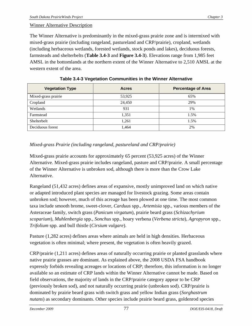
South Dakota PrairieWinds Project Chapter 3
Winner Alternative Description
The Winner Alternative is predominantly in the mixed-grass prairie zone and is intermixed with mixed-grass prairie (including rangeland, pastureland and CRP/prairie), cropland, wetlands (including herbaceous wetlands, forested wetlands, stock ponds and lakes), deciduous forests, farmsteads and shelterbelts (Table 3.4-3 and Figure 3.4-3). Elevations range from 1,985 feet AMSL in the bottomlands at the northern extent of the Winner Alternative to 2,510 AMSL at the western extent of the area.
Table 3.4-3 Vegetation Communities in the Winner Alternative
Vegetation Type Acres Percentage of Area
Mixed-grass prairie 53,925 65% Cropland 24,450 29% Wetlands 931 1% Farmstead 1,351 1.5% Shelterbelt 1,261 1.5% Deciduous forest 1,464 2%
Mixed-grass Prairie (including rangeland, pastureland and CRP/prairie)
Mixed-grass prairie accounts for approximately 65 percent (53,925 acres) of the Winner Alternative. Mixed-grass prairie includes rangeland, pasture and CRP/prairie. A small percentage of the Winner Alternative is unbroken sod, although there is more than the Crow Lake Alternative.
Rangeland (51,432 acres) defines areas of expansive, mostly unimproved land on which native or adapted introduced plant species are managed for livestock grazing. Some areas contain unbroken sod; however, much of this acreage has been plowed at one time. The most common taxa include smooth brome, sweet-clover, Carduus spp., Artemisia spp., various members of the Asteraceae family, switch grass (Panicum virgatum), prairie beard grass (Schizachyrium scoparium), Muhlenbergia spp., Sonchus spp., hoary verbena (Verbena stricta), Agropyron spp., Trifolium spp. and bull thistle (Cirsium vulgare).
Pasture (1,282 acres) defines areas where animals are held in high densities. Herbaceous vegetation is often minimal; where present, the vegetation is often heavily grazed.
CRP/prairie (1,211 acres) defines areas of naturally occurring prairie or planted grasslands where native prairie grasses are dominant. As explained above, the 2008 USDA FSA handbook expressly forbids revealing acreages or locations of CRP; therefore, this information is no longer available so an estimate of CRP lands within the Winner Alternative cannot be made. Based on field observations, the majority of lands in the CRP/prairie category appear to be CRP (previously broken sod), and not naturally occurring prairie (unbroken sod). CRP/prairie is dominated by prairie beard grass with switch grass and yellow Indian grass (Sorghastrum nutans) as secondary dominants. Other species include prairie beard grass, goldenrod species
December 2009 77 DOE/EIS-0418, Draft
Chapter 3 South Dakota PrairieWinds Project
(Solidago spp.), evening-primrose (Oenothera spp.), Juncus spp., hoary verbena (Verbena stricta), Artemisia spp. and various members of the Asteraceae family.
The USFWS has approximately 220 acres of grasslands in one parcel enrolled in the Grassland Easement program within the Winner Alternative and no Wetland Easements (USFWS 2008). The Grassland Easement is included in the mixed-grass prairie land use category in Table 3.4-3 and Figure 3.4-4.
Cropland
Cropland accounts for approximately 29 percent (24,450 acres) of the Winner Alternative. Cropland classifications are the same as described in Section 3.4.3.1.
Wetlands (including deciduous wetland, forested wetland, lake, stock pond, wetland and wet meadow)
Wetlands account for slightly over one percent (931 acres) of the Winner Alternative. A variety of wetland complexes, composed of wet meadow, shrub-carr and deciduous wetland forest communities are located within the site. The deciduous wetland communities are dominated by plains cottonwood; the wet meadow communities are dominated by prairie cord grass, switch grass, river bulrush, reed canary grass, narrow-leaved cattail and Juncus spp. The shrub-carr communities are dominated by willow (Salix spp.) and olive species (Elaeagnus spp.). The forested wetland communities are dominated by cottonwood and willow species (Salix spp.). These vegetation communities are often within rangeland.
Stock ponds are areas that are bermed (natural drainage features or seasonal wetlands) to create a persistent water supply for livestock. These areas are often heavily grazed and do not contain a perimeter of hydrophytic vegetation.
Deciduous Forest
Deciduous forest accounts for approximately 2 percent (1,464 acres) of the Winner Alternative. This designation describes areas of dense, naturally occurring tree species. In upland areas, plains cottonwood is most abundant; occurrences of eastern red-cedar, Siberian elm, box elder (Acer negundo), green ash and wild plum are also present. This vegetation community is often islands within rangeland.
Farmstead and Shelterbelt
Farmsteads account for approximately 1.5 percent (1,351 acres) of the Winner Alternative and are similar to those described in Section 3.4.3.1. Shelterbelts account for approximately 1.5 percent (1,261 acres) of the Winner Alternative. Species composition of the shelterbelts is similar to that seen at Crow Lake.
DOE/EIS-0418, Draft 78 December 2009
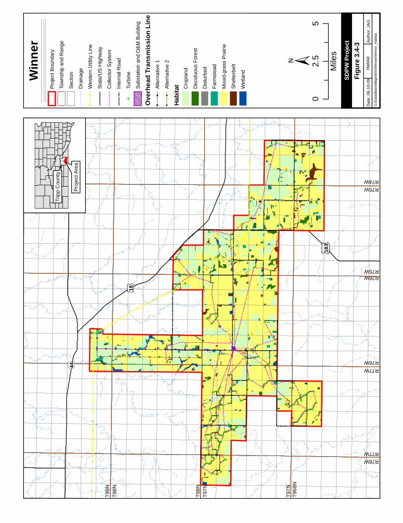
!!
!!
!!
!!
!!
!!
!!
!!
!!
!!
!!
!!
!!
!!
!
!
!
!
!
!
!
!
!
!
!
!
!
!
!
!
!
!
!
!!
!!
!!
!!
!!
!!
!!
!!
!!
!!
!!
!
!
!
!
!
!
!
!
!
!
!
!
!
!
!
!
!
!
!
!
!
!
!
!
!
!
!
!
!
!
!!
!!
!!
!!
!!
!!
!!
!!
!!
!!
!!
!!
!!
!!
!!
!!
!!
!!
!!
!!
!!
!!
!
!
!!!!!!!!!!!!!!!
!
!!!!!!!!!!!
!
!(
!(
!(
!(
!(
!(!(
!(!(
!(
!(
!(
!( !(
!(
!(
!(
!(
!(
!(
!(
!(
!(
!(
!(
!(
!(
!(!(
!(!(
!(
!(
!(
!(!(
!(
!(
!(
!(
!(
!(
!(
!(
!(
!(
!( !(
!(
!(
!(
!( !(
!(
!(
!(
!(
!(
!(
!(
!(
!(
!(
!(
!(
!(
!(
!(
!(
!(
!(
!(
!(
!(
!(
!(
!(
!(
!(
!(
!(
!(
!(
!(!(
!(
!(
!(
!(
!(
!(
!(
!(
!(
!(!(
!(
!(
!(
!(
!(
!(
!(
!(
!(
!(
!(
!(!(
!(
!(
¬ «44
£ ¤18
£ ¤183
±
Winn
erPr
ojec
t Bou
ndar
y
Tow
nshi
p an
d R
ange
Sect
ion
Dra
inag
e!
!W
este
rn U
tility
Lin
e
Stat
e/U
S H
ighw
ay
Col
lect
or S
yste
m
Inte
rnal
Roa
d
!(Tu
rbin
e
Subs
tatio
n an
d O
&M
Bui
ldin
g
Over
head
Tran
smiss
ion Li
ne!
!Al
tern
ativ
e 1
!!
Alte
rnat
ive
2
Habit
at Cro
plan
d
Dec
iduo
us F
ores
t
Dis
turb
ed
Farm
stea
d
Mix
ed-g
rass
Pra
irie
Shel
terb
elt
Wet
land
02.
55
Mile
s
Papa
go R
dD
ate:
06.
10.0
9Au
thor
: JA
GG
:\Dat
a\Ba
sin\
Map
s\EI
S\W
inne
r\Win
ner_
Hab
itat
SDPW
Proje
ct
Hab
itat
Trip
p C
ount
y
Pro
ject
Are
a
Figur
e 3.4-
3
R77WR76W
R76WR75W
T966
NT9
7N
T98N
T99N
R78WR77W
R75WR74W
T97N
T98N
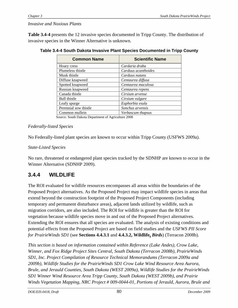
Chapter 3 South Dakota PrairieWinds Project
Invasive and Noxious Plants
Table 3.4-4 presents the 12 invasive species documented in Tripp County. The distribution of invasive species in the Winner Alternative is unknown.
Table 3.4-4 South Dakota Invasive Plant Species Documented in Tripp County
Common Name Scientific Name Hoary cress Cardaria draba Plumeless thistle Carduus acanthoides Musk thistle Carduus nutans Diffuse knapweed Centaurea diffusa Spotted knapweed Centaurea maculosa Russian knapweed Centaurea repens Canada thistle Cirsium arvense Bull thistle Cirsium vulgare Leafy spurge Euphorbia esula Perennial sow thistle Sonchus arvensis Common mullein Verbascum thapsus
Source: South Dakota Department of Agriculture 2008
Federally-listed Species
No Federally-listed plant species are known to occur within Tripp County (USFWS 2009a).
State-Listed Species
No rare, threatened or endangered plant species tracked by the SDNHP are known to occur in the Winner Alternative (SDNHP 2009).
3.4.4 WILDLIFE
The ROI evaluated for wildlife resources encompasses all areas within the boundaries of the Proposed Project alternatives. As the Proposed Project may impact wildlife species in areas that extend beyond the construction footprint of the Proposed Project Components (including temporary and permanent disturbance areas), adjacent lands utilized by wildlife, such as migration corridors, are also included. The ROI for wildlife is greater than the ROI for vegetation because wildlife species move in and out of the Proposed Project alternatives. Extending the ROI ensures that all species are evaluated. The analysis of existing conditions and potential effects from the Proposed Project are based on field studies and the USFWS PII Score for PrairieWinds SD1 (see Sections 4.4.3.1 and 4.4.3.2, Wildlife, Birds) (Terracon 2008b).
This section is based on information contained within Reference (Lake Andes), Crow Lake, Winner, and Fox Ridge Project Sites Central, South Dakota (Terracon 2008b), PrairieWinds SD1, Inc. Project Compilation of Resource Technical Memorandums (Terracon 2009a and 2009b), Wildlife Studies for the PrairieWinds SD1 Crow Lake Wind Resource Area Aurora, Brule, and Jerauld Counties, South Dakota (WEST 2009a), Wildlife Studies for the PrairieWinds SD1 Winner Wind Resource Area Tripp County, South Dakota (WEST 2009b), and Prairie Winds Vegetation Mapping, NRC Project # 009-0044-01, Portions of Jerauld, Aurora, Brule and
DOE/EIS-0418, Draft 80 December 2009
!!
!!
!!
!!
!!
!!
!!
!!
!!
!!
!!
!
!
!
!
!
!
!
!
!
!
!
!
!
!
!
!
!!
!!
!!
!!
!!
!!
!!
!!
!!
!
!
!
!
!
!
!
!
!
!
!
!
!
!
!
!
!
!
!
!
!
!
!
!
!!
!!
!!
!!
!!
!!
!!
!!
!
!
!
!
!
!
!
!!
!!
!!
!!
!!
!
!
!
!!!!!!!!!!!!
!
!
!!!!!!!!!
!(
!(
!(
!(
!(
!(!(
!(!(
!(!(
!(
!( !(
!(
!(
!(
!(
!(
!(
!(
!(
!(
!(
!(
!(
!(
!(!(
!(!(
!(
!(
!(
!(!(
!(
!(
!(
!(
!(
!(
!(
!(
!(
!(
!( !(
!(
!(
!(
!( !(
!(
!(
!(
!(
!(
!(
!(
!(
!(
!(
!(
!(
!(
!(
!(
!(
!(
!(
!(
!(
!(
!(
!(
!(
!(
!(
!(
!(
!(
!(
!(!(
!(
!(
!(
!(
!(
!(
!(
!(
!(
!(!(
!(
!(
!(
!(
!(
!(
!(
!(
!(
!(
!(
!(!(
!(
!(
¬«44
£ ¤18
£ ¤183
Amer
ican
Bur
ying
Bee
tle
Pear
l Dac
e
Hai
ry P
ucco
on
Who
opin
g C
rane
Who
opin
g C
rane
Plai
ns T
opm
inno
w
Long
-bille
d C
urle
w
Plai
ns L
eopa
rd F
rog
Who
opin
g C
rane
Nor
ther
n R
edbe
lly D
ace
Blac
k-fo
oted
Fer
ret
Trum
pete
r Sw
an
Trum
pete
r Sw
an
Trum
pete
r Sw
an
Pear
l Dac
e
Bush
Clo
ver
Reg
al F
ritill
ary
Man
y-lin
ed S
kink
Wes
tern
Box
Tur
tle
Plai
ns S
potte
d Sk
unk
Plai
ns S
potte
d Sk
unk
Less
er E
arle
ss L
izar
d
Four
poin
t Eve
ning
Prim
rose
Big
Blu
este
m-s
witc
hgra
ss S
ubirr
igat
ed M
eado
w
Nor
ther
n Pr
airie
Liz
ard
Plai
ns T
opm
inno
w
Mar
gine
d R
ush
Hai
ry P
ucco
on
±
Winn
erPr
ojec
t Bou
ndar
y
Tow
nshi
p an
d R
ange
Sect
ion
Stat
e/U
S H
ighw
ay!
!
Wes
tern
Util
ity L
ine
!(Tu
rbin
e
Subs
tatio
n an
d O
&M B
uild
ing
Col
lect
or S
yste
m
Inte
rnal
Roa
d
Over
head
Tran
smiss
ion Li
ne!
!Al
tern
ativ
e 1
!!
Alte
rnat
ive
2
USF
WS
Gra
ssla
nd E
asem
ent
Gam
e P
rodu
ctio
n Ar
eas
Natu
ral H
erita
ge H
abita
tSp
ecie
s O
ccur
renc
e
Amer
ican
Bur
ying
Bee
tle
Dra
inag
e
Maj
or W
ater
Bod
ies
(EPA
)
02.
55
Mile
s
Trip
p C
ount
y
Pro
ject
Are
a
Papa
go R
dAu
thor
: JA
G
SDPW
Proje
ct
Con
serv
atio
nAr
eas
R77WR76W
R76WR75W
T966
NT9
7N
T98N
T99N
R78WR77W
R75WR74W
T97N
T98N
Dat
e: 0
6.10
.09
G:\D
ata\
Basi
n\M
aps\
EIS
\Win
ner\W
inne
r_C
onse
rvat
ion
Figur
e 3.4-
4
Chapter 3 South Dakota PrairieWinds Project
Tripp Counties, South Dakota (Tierra EC 2009). Where additional sources of information have been used to evaluate the potential impacts associated with the Proposed Project, those sources have been cited.
3.4.4.1 Crow Lake Alternative
Terrestrial fauna within the Crow Lake Alternative are characteristic of mixed grasslands within the PPR. Fertile soils and high wetland basin density provide an abundance of forage and habitat cover for species of small mammals, amphibians, reptiles and birds, although wetland density is relatively low at the Crow Lake Alternative when compared to the PPR (Kempema 2007). Wildlife shares the region with cattle and other livestock. Agricultural practices have reduced the amount and continuity of prairie and wetland habitat. Smaller patches of prairie and wetland are now often intermixed with woody species in tree rows and shelterbelts. A list of wildlife species observed during field surveys in 2008 and 2009 is provided in Appendix C, Table C-1. A total of 100 bird species, 12 mammal species and one amphibian were observed.
Hunting is a popular recreational activity in and around the Crow Lake Alternative. Game species pursued most frequently include pheasants and other upland gamebirds, white-tailed deer, fox, coyotes and waterfowl. Review of State and Federal databases indicates that there are no WPAs, State Game Production Areas (GPA) or Walk-in Areas within the Crow Lake Alternative (SDGFP 2009a and 2009b) (Figure 3.4-2).
Mammals
Habitat models produced by the South Dakota GAP Analysis Program (Smith et al. 2001) were consulted to identify common wildlife species that may occur within the Crow Lake Alternative.
In addition to the species observed, the GAP analysis predicts mammals including fox (Vulpes vulpes), bobcat (Lynx rufus), opossum (Didelphidae), raccoon (Procyon lotor) and those listed in Appendix C, Table C-2. Small burrowing mammals, such as shrews, voles, mice and gophers, use soft soils for denning and cover. Game species include pronghorn (Antilocapra americana), mule deer and white-tailed deer. White-tailed deer are considered common in the area.
Bat species reside in and migrate through the region. Thirteen species of bats are documented in South Dakota, seven of which may occur in the Crow Lake Alternative (SDGFP 2004; SDGFP 2007; Kempema 2007)(Table 3.4-5).
Specific information regarding roosting, breeding, foraging and migration is unknown for bats in the Crow Lake Alternative. Areas adjacent to pothole lakes and wetlands are mesic and support cover and foraging habitat for mammal species. Peaks in insect hatches during warm season months provide a good prey base for many mammals. Bat use surveys were performed from May 1 to October 15, 2009. Results were not available at the time of publication of this DEIS but will be included in the FEIS. The surveys are being performed using Anabat, a system to identify and survey bats by detecting and analyzing their echolocation calls.
DOE/EIS-0418, Draft 82 December 2009
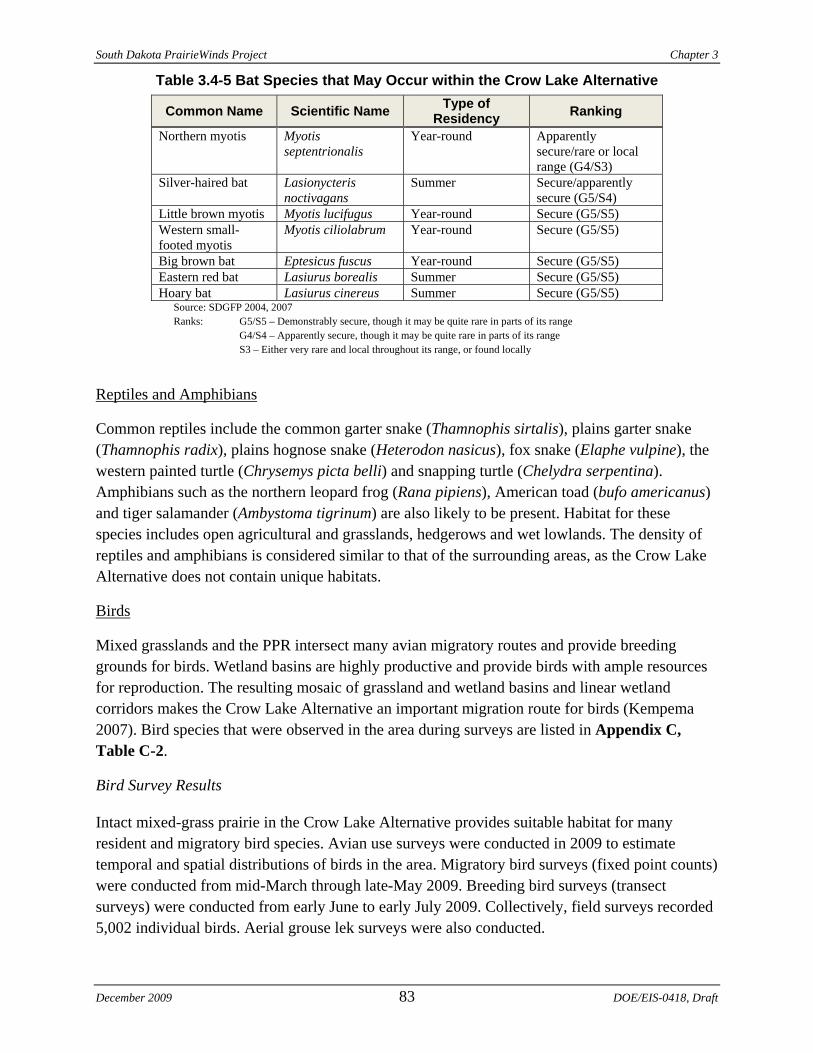
South Dakota PrairieWinds Project Chapter 3
Table 3.4-5 Bat Species that May Occur within the Crow Lake Alternative
Common Name Scientific Name Type of Residency Ranking
Northern myotis Myotis septentrionalis
Year-round Apparently secure/rare or local range (G4/S3)
Silver-haired bat Lasionycteris noctivagans
Summer Secure/apparently secure (G5/S4)
Little brown myotis Myotis lucifugus Year-round Secure (G5/S5) Western small-footed myotis
Myotis ciliolabrum Year-round Secure (G5/S5)
Big brown bat Eptesicus fuscus Year-round Secure (G5/S5) Eastern red bat Lasiurus borealis Summer Secure (G5/S5) Hoary bat Lasiurus cinereus Summer Secure (G5/S5)
Source: SDGFP 2004, 2007 Ranks: G5/S5 – Demonstrably secure, though it may be quite rare in parts of its range G4/S4 – Apparently secure, though it may be quite rare in parts of its range S3 – Either very rare and local throughout its range, or found locally
Reptiles and Amphibians
Common reptiles include the common garter snake (Thamnophis sirtalis), plains garter snake (Thamnophis radix), plains hognose snake (Heterodon nasicus), fox snake (Elaphe vulpine), the western painted turtle (Chrysemys picta belli) and snapping turtle (Chelydra serpentina). Amphibians such as the northern leopard frog (Rana pipiens), American toad (bufo americanus) and tiger salamander (Ambystoma tigrinum) are also likely to be present. Habitat for these species includes open agricultural and grasslands, hedgerows and wet lowlands. The density of reptiles and amphibians is considered similar to that of the surrounding areas, as the Crow Lake Alternative does not contain unique habitats.
Birds
Mixed grasslands and the PPR intersect many avian migratory routes and provide breeding grounds for birds. Wetland basins are highly productive and provide birds with ample resources for reproduction. The resulting mosaic of grassland and wetland basins and linear wetland corridors makes the Crow Lake Alternative an important migration route for birds (Kempema 2007). Bird species that were observed in the area during surveys are listed in Appendix C, Table C-2.
Bird Survey Results
Intact mixed-grass prairie in the Crow Lake Alternative provides suitable habitat for many resident and migratory bird species. Avian use surveys were conducted in 2009 to estimate temporal and spatial distributions of birds in the area. Migratory bird surveys (fixed point counts) were conducted from mid-March through late-May 2009. Breeding bird surveys (transect surveys) were conducted from early June to early July 2009. Collectively, field surveys recorded 5,002 individual birds. Aerial grouse lek surveys were also conducted.
December 2009 83 DOE/EIS-0418, Draft
Chapter 3 South Dakota PrairieWinds Project
Preliminary results for migratory bird surveys indicate a total of 60 unique bird species; a total of 2,178 individual birds were recorded (Appendix C, Table C-2 and Table C-3). Fifty-eight individual raptors in 56 groups were recorded (2.7 percent of overall bird observations), representing eight species. Northern Harrier and Red-tailed Hawk were the most frequently observed raptor species. Waterfowl were by far the most abundant bird type comprising 48.4 percent of observations. Canada Geese (Branta canadensis) and Mallards (Anas platyrhynchos) were the most commonly observed waterfowl. Passerines were the second most abundant bird type, accounting for 24.5 percent of overall bird observations, with Red-winged Blackbird (Agelaius phoeniceus) and Western Meadowlark (Sturnella neglecta) being the most commonly observed passerine species (WEST 2009a).
A total of 2,824 individual bird observations were recorded during breeding bird surveys, representing 59 unique species. Cumulatively, four species (6.8 percent of all species) accounted for 85.4 percent of observations: Brown-headed Cowbird, Western Meadowlark, Grasshopper Sparrow and Red-winged Blackbird, which are species typical of open grassland habitats. Over half of the birds observed during breeding bird surveys were blackbirds and orioles. Woodland and wetland birds were also observed, but were less abundant than grassland species.
Upland game bird species known to occur in the Crow Lake Alternative include Ring-necked Pheasant, Greater Prairie Chicken and Sharp-tailed Grouse. Ring-necked Pheasant habitat includes primarily mixed grasses and cropland. There are few intact native grasslands in the area; these areas provide habitat for Sharp-tailed Grouse and Greater Prairie Chicken. Sharp-tailed Grouse and Greater Prairie Chicken were documented during spring and summer surveys (WEST 2009a; Tierra EC 2009). Five grouse leks were identified during aerial surveys. Four are within the Crow Lake Alternative and one is immediately adjacent to the site. Two of the leks were confirmed to species (one Sharp-tailed Grouse and one Greater Prairie Chicken). The remaining three could not be identified to species (WEST 2009a).
Waterfowl utilize the wetland basins in and adjacent to the Crow Lake Alternative for nesting, foraging and migratory stopover. WPAs are USFWS preserves with quality habitat often used by waterfowl. There are no WPAs within the Crow Lake Alternative; the closest WPA is approximately seven miles to the southeast. Wetlands, streams, ponds and lakes in and near the site provide nesting, foraging and cover habitat for several shorebird species. Two groups of Sandhill Cranes (18 individuals) were observed at the Crow Lake Alternative (WEST 2009a). Sandhill Cranes are often used as a surrogate species for Whooping Cranes because they use similar habitat types. Preliminary results from one year of data collection indicate that the number of individuals observed indicates that habitat suitability for Sandhill Cranes is low; more data collection is needed to confirm this.
Based on the results from other wind resource areas, a ranking of seasonal mean raptor use was developed (WEST 2009a). Raptor use at the Crow Lake Alternative is 0.35 birds per plot per survey. Raptor use at sites around the United States is between 1.65 and 0.1 birds per plot per survey (WEST 2009a). Although habitats in these wind resource areas are not necessarily the
DOE/EIS-0418, Draft 84 December 2009
South Dakota PrairieWinds Project Chapter 3
same as those at the Crow Lake Alternative, they provide the best available comparison for raptor use. Based on this analysis, raptor use is relatively low at the Crow Lake Alternative.
The Crow Lake Alternative occurs in the Central Flyway, a major migration corridor through the United States. Avian use surveys conducted in the Crow Lake Alternative indicate that spring and fall migration of songbirds, waterfowl and raptors occurs in the region. There are no topographic features, such as mountain passes or large rivers, which funnel or direct migratory paths to the area or certain portions of the area. Both raptors and songbirds migrate along a broad front throughout the region. Topographic relief in the area is primarily associated with the ridgetop that runs through the site from the southwest portion to the northeast portion. This ridge may provide a source of updrafts that could be used by soaring raptors. Concentrated prey sources, specifically waterfowl, fluctuate seasonally with migrations. Concentrations of waterfowl are expected to be higher in the spring and fall, so raptor populations may increase during those periods. Roosting trees are limited in the area.
Nesting habitat in the Crow Lake Alternative is limited for above ground nesting raptor species and includes scattered trees, tree rows and shelterbelts. No cliffs or rock outcrops were identified during field studies. Ground-nesting raptors likely nest in areas of continuous grassland habitats within the Crow Lake Alternative. Field studies did not reveal raptor nests within the area (WEST 2009a; Tierra EC 2009), although it is likely that raptors nest here.
3.4.4.2 Winner Alternative
Terrestrial fauna within the Winner Alternative are characteristic of mixed grasslands within the mixed-grass prairie zone. Fertile soils provide an abundance of forage and habitat cover for many species of small mammals, amphibians, reptiles and birds. Wetlands provide habitat for many species, although wetland densities are relatively low when compared to the region. Wildlife shares the region with cattle and other livestock. Agricultural practices have reduced the amount and continuity of prairie and wetland habitat. As a result, patches of habitat have become smaller and are often intermixed with woody species in tree rows and shelterbelts. A list of wildlife species observed during field surveys in 2008 and 2009 is provided in Appendix C, Table C-4. A total of 98 bird species, 12 mammal species, two reptile species and two amphibian species were observed.
Hunting is a popular recreational activity in and around the Winner Alternative. Game species pursued most frequently include pheasants and other upland gamebirds, white-tailed deer, fox, coyotes and waterfowl. Review of State and Federal databases indicates that there are no Waterfowl Production Areas or Walk-in Areas within the Winner Alternative (SDGFP 2009a and 2009b). The Little Dog Ear Lake GPA is located in the western portion of the site and is approximately 77 acres (Figure 3.4-4).
Mammals
Common mammal species residing in the Winner Alternative are similar to those described in Section 3.4.4.1.
December 2009 85 DOE/EIS-0418, Draft
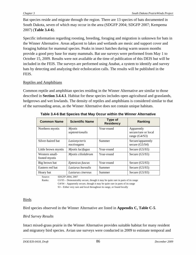
Chapter 3 South Dakota PrairieWinds Project
Bat species reside and migrate through the region. There are 13 species of bats documented in South Dakota, seven of which may occur in the area (SDGFP 2004; SDGFP 2007; Kempema 2007) (Table 3.4-6).
Specific information regarding roosting, breeding, foraging and migration is unknown for bats in the Winner Alternative. Areas adjacent to lakes and wetlands are mesic and support cover and foraging habitat for mammal species. Peaks in insect hatches during warm season months provide a good prey base for many mammals. Bat use surveys were performed from May 1 to October 15, 2009. Results were not available at the time of publication of this DEIS but will be included in the FEIS. The surveys are performed using Anabat, a system to identify and survey bats by detecting and analyzing their echolocation calls. The results will be published in the FEIS.
Reptiles and Amphibians
Common reptile and amphibian species residing in the Winner Alternative are similar to those described in Section 3.4.4.1. Habitat for these species includes open agricultural and grasslands, hedgerows and wet lowlands. The density of reptiles and amphibians is considered similar to that of the surrounding areas, as the Winner Alternative does not contain unique habitats.
Table 3.4-6 Bat Species that May Occur within the Winner Alternative
Common Name Scientific Name Type of Residency Ranking
Northern myotis Myotis septentrionalis
Year-round Apparently secure/rare or local range (G4/S3)
Silver-haired bat Lasionycteris noctivagans
Summer Secure/apparently secure (G5/S4)
Little brown myotis Myotis lucifugus Year-round Secure (G5/S5) Western small-footed myotis
Myotis ciliolabrum Year-round Secure (G5/S5)
Big brown bat Eptesicus fuscus Year-round Secure (G5/S5) Eastern red bat Lasiurus borealis Summer Secure (G5/S5) Hoary bat Lasiurus cinereus Summer Secure (G5/S5)
Source: SDGFP 2004, 2007 Ranks: G5/S5 – Demonstrably secure, though it may be quite rare in parts of its range G4/S4 – Apparently secure, though it may be quite rare in parts of its range S3 – Either very rare and local throughout its range, or found locally
Birds
Bird species observed in the Winner Alternative are listed in Appendix C, Table C-5.
Bird Survey Results
Intact mixed-grass prairie in the Winner Alternative provides suitable habitat for many resident and migratory bird species. Avian use surveys were conducted in 2009 to estimate temporal and
DOE/EIS-0418, Draft 86 December 2009
South Dakota PrairieWinds Project Chapter 3
spatial distributions of birds in the area. Fixed point count migratory bird surveys were conducted from early-April through late-May 2009. Transect surveys for breeding birds were conducted from early-June to early-July 2009. Collectively, field surveys recorded 3,455 individual birds.
Preliminary results for migratory bird surveys indicate a total of 58 unique bird species. A total of 1,223 individual birds were recorded (Appendix C, Table C-5 and Table C-6). Thirty individual raptors in 27 separate groups were recorded (2.2 percent of overall bird observations), representing seven species. Northern Harrier was the most frequently observed raptor species. Passerines were the most abundant bird type comprising 45.1 percent of observations, primarily due to high numbers of Red-winged Blackbird and Western Meadowlark. Upland gamebirds were the second most abundant bird type, accounting for 18.8 percent of observations, with primarily Ring-necked Pheasant. Waterbirds were also relatively abundant compared to other birds types with 115 birds observed in eight separate groups. The most abundant waterbird species was Double-crested Cormorant (WEST 2009b).
A total of 2,232 individual bird observations within 1,744 separate groups were recorded during breeding bird surveys, representing 53 unique species. Cumulatively, six species (11.3 percent of all species) composed 67.6 percent of the individual observations: Brown-headed Cowbird, Western Meadowlark, Red-winged Blackbird, Savanna Sparrow, Bobolink and Upland Sandpiper. Blackbirds and orioles were the most abundant passerine subtype, accounting for nearly half of all observations (WEST 2009b).
Upland game bird species are the same as at the Crow Lake Alternative (WEST 2009b; Tierra EC 2009), although habitats for these species are more abundant because the Winner Alternative has larger areas of intact grasslands. Eight grouse leks were located and confirmed. Two of the confirmed leks were verified as Greater Prairie Chicken. The other six leks could not be confirmed to species (WEST 2009b).
There are no WPAs within or near the area. No Sandhill Cranes were observed while conducting surveys at the Winner Alternative (WEST 2009b). Sandhill Cranes are often used as a surrogate species for Whooping Cranes because they use similar habitat types. From one year of data collection, the number of individuals observed indicates that habitat suitability for Sandhill Cranes is low; more data collection is needed to confirm this.
Raptor use at the Winner Alternative was observed around 0.25 birds per plot per survey. Raptor use at different sites around the United States has been observed between 1.65 and 0.1 birds per plot per survey (WEST 2009b). Although habitats in these wind resource areas are not necessarily the same as those at the Winner Alternative, they provide the best available comparison for raptor use. Based on this analysis, raptor use is relatively low.
Nesting habitat in the Winner Alternative is limited for above ground nesting raptor species and includes scattered trees, tree rows and shelterbelts. No cliffs or rock outcrops were identified during field studies. Ground-nesting raptors likely nest in areas of continuous grassland habitats
December 2009 87 DOE/EIS-0418, Draft
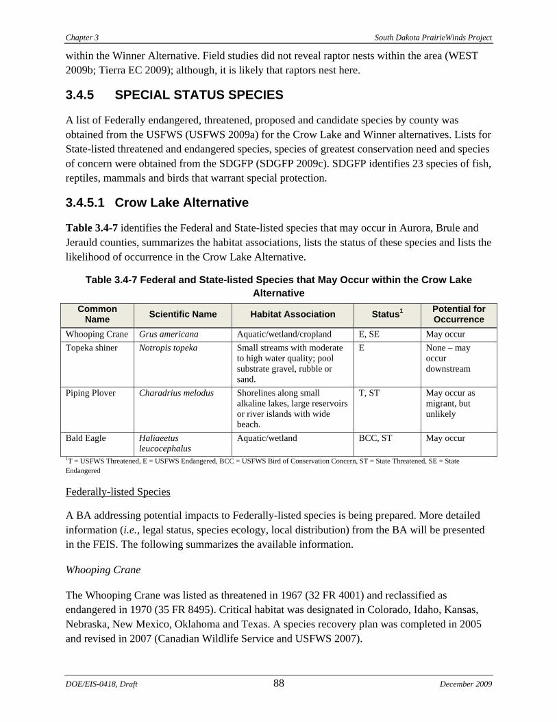
Chapter 3 South Dakota PrairieWinds Project
within the Winner Alternative. Field studies did not reveal raptor nests within the area (WEST 2009b; Tierra EC 2009); although, it is likely that raptors nest here.
3.4.5 SPECIAL STATUS SPECIES
A list of Federally endangered, threatened, proposed and candidate species by county was obtained from the USFWS (USFWS 2009a) for the Crow Lake and Winner alternatives. Lists for State-listed threatened and endangered species, species of greatest conservation need and species of concern were obtained from the SDGFP (SDGFP 2009c). SDGFP identifies 23 species of fish, reptiles, mammals and birds that warrant special protection.
3.4.5.1 Crow Lake Alternative
Table 3.4-7 identifies the Federal and State-listed species that may occur in Aurora, Brule and Jerauld counties, summarizes the habitat associations, lists the status of these species and lists the likelihood of occurrence in the Crow Lake Alternative.
Table 3.4-7 Federal and State-listed Species that May Occur within the Crow Lake Alternative
Common Name Scientific Name Habitat Association Status1 Potential for
Occurrence Whooping Crane Grus americana Aquatic/wetland/cropland E, SE May occur Topeka shiner Notropis topeka Small streams with moderate
to high water quality; pool substrate gravel, rubble or sand.
E None – may occur downstream
Piping Plover Charadrius melodus Shorelines along small alkaline lakes, large reservoirs or river islands with wide beach.
T, ST May occur as migrant, but unlikely
Bald Eagle Haliaeetus leucocephalus
Aquatic/wetland BCC, ST May occur
1T = USFWS Threatened, E = USFWS Endangered, BCC = USFWS Bird of Conservation Concern, ST = State Threatened, SE = State Endangered
Federally-listed Species
A BA addressing potential impacts to Federally-listed species is being prepared. More detailed information (i.e., legal status, species ecology, local distribution) from the BA will be presented in the FEIS. The following summarizes the available information.
Whooping Crane
The Whooping Crane was listed as threatened in 1967 (32 FR 4001) and reclassified as endangered in 1970 (35 FR 8495). Critical habitat was designated in Colorado, Idaho, Kansas, Nebraska, New Mexico, Oklahoma and Texas. A species recovery plan was completed in 2005 and revised in 2007 (Canadian Wildlife Service and USFWS 2007).
DOE/EIS-0418, Draft 88 December 2009
South Dakota PrairieWinds Project Chapter 3
The Whooping Crane occurs at three locations in the wild and at nine captive sites (Canadian Wildlife Service and USFWS 2007). The only self-sustaining wild population is the Aransas-Wood Buffalo National Park population, which migrates between summer nesting grounds in Wood Buffalo National Park in Canada and winter habitat in the coastal marshes of Aransas National Wildlife Refuge in Texas. Spring migration begins in late-March to early-April and is completed within two to four weeks (Austin and Richert 2001). In the fall, the Aransas-Wood Buffalo National Park population conducts the return 2,600-mile migration. This migration route approximately follows the Missouri River corridor through the midwestern United States. The corridor is approximately 200 miles wide. While Whooping Cranes use a variety of habitats during migration, they primarily roost in shallow, seasonally and semi-permanently flooded, palustrine wetlands, and forage in sub-irrigated wet meadows and cultivated agricultural lands (Lewis 1995; Austin and Richert 2001; Stehn 2007). Most wetlands used for roosting are small (less than 10 acres) and located within 0.5 miles of a suitable feeding site.
Stopover occurrence during migration is common throughout South Dakota; there were 214 observations of Whooping Cranes in South Dakota between 1943 and 2007. The majority of sightings were in the central portion of the State along the Missouri River corridor (Austin and Richert 2001). Whooping Cranes have not been observed in Jerauld County, although they have been sighted in Brule and Aurora counties.
The Crow Lake Alternative is within the 75 and 80 percentile bands of the approximate 200-mile migration corridor. No Whooping Cranes were observed during the avian use surveys conducted in the Crow Lake Alternative (WEST 2009a). The Crow Lake Alternative contains numerous small wetlands, prairie pothole lakes, mixed grasses and cultivated fields. Crow Lake is the largest body of water in the project vicinity. Nielson North is the closest WPA, and emergent and submergent wetland vegetation is present in the lake at the Nielson North WPA. Wetland habitat represents one percent of the Crow Lake Alternative, some of which is Whooping Crane roosting habitat. The area also contains 33 percent cropland and is dominated by grasslands, both of which could be used as foraging habitat. Although the site is located near the edge of the migration corridor, previous sightings in Aurora and Brule counties suggest that Whooping Cranes may occasionally fly over the area during seasonal migrations. Historical occurrence, location of the site within the migration corridor, and the presence of suitable foraging, roosting and stopover habitat indicate that Whooping Cranes may occur in the Crow Lake Alternative (Stehn 2007).
Piping Plover
The Piping Plover was listed as threatened on December 11, 1985 (50 FR 50726-50734) in its entire range except for the Great Lakes watershed, where it was listed as endangered. The final rule designating critical habitat for the wintering population of the Piping Plover was published in the Federal Register on July 10, 2001 (50 CFR 17 36038-36143).
The breeding range of the Northern Great Plains population of the Piping Plover includes wetlands in southeastern Alberta and the midwestern United States, including South Dakota. The
December 2009 89 DOE/EIS-0418, Draft
Chapter 3 South Dakota PrairieWinds Project
Piping Plover winters primarily on the Gulf of Mexico coast. Critical breeding habitat has been designated in areas of South Dakota.
The Piping Plover is known to nest from mid-April to mid-August on sparsely vegetated sandbars in rivers and on sand piles resulting from sand and gravel mining operations. They are also known to use inland alkali wetlands.
According to the USGS Breeding Birds of South Dakota Database, there have been no documented occurrences of the Piping Plover in Jerauld, Brule and Aurora counties (including the Crow Lake Alternative) to date.
Since Piping Plovers primarily occur along river corridors, they are unlikely to occur in the upland portions of the Crow Lake Alternative. Piping Plovers may migrate through the area during spring and fall migration. However, due to the absence of rivers and reservoirs within or near the Proposed Project, they would be infrequent visitors to the area, mostly in spring and fall.
Topeka Shiner
This species was listed by USFWS in December 1998. Critical habitat was designated on July 27, 2004. There is no designated critical habitat in South Dakota (Shearer 2003).
The Topeka shiner is a small pool dwelling minnow that is found in prairie streams of the lower Missouri River Basin and upper Mississippi River Basin. The range of this fish covers eastern South Dakota, southwest Minnesota, eastern Nebraska, Iowa, northern Kansas and Missouri. In South Dakota, the Topeka shiner has been found in about 40 streams in the James River, Big Sioux River and Vermillion River watersheds. The Topeka shiner currently retains its historic distribution and is locally abundant in South Dakota; however, population trends are unclear.
According to the SDDOT website, the species was observed in the Firesteel Creek and the West Branch Firesteel Creek, approximately 25 miles downstream of the Crow Lake Alternative, as recently as 2006 (SDDOT 2006). The eastern portion of the site (within Aurora County) supports the headwaters of three small tributaries to West Branch Firesteel Creek. Shearer (2003) lists BMPs for crossing streams inhabited by the Topeka shiner.
State-Listed Species
Whooping Crane (State Endangered)
The legal status, species ecology and local distribution of Whooping Cranes are discussed above.
Bald Eagle (State Threatened)
In 1978, the Bald Eagle was designated as a Federally-endangered species throughout most of the lower 48 states (43 FR 6233). The species was subsequently downlisted to threatened and in August 2007, the Bald Eagle was de-listed (USFWS 2007). The Bald Eagle remains protected under the Federal BGEPA and MBTA. The Bald Eagle is also listed as threatened by SDGFP (2007).
DOE/EIS-0418, Draft 90 December 2009
South Dakota PrairieWinds Project Chapter 3
Bald Eagle habitat consists of large trees in proximity to water bodies that support fish populations (Groves et al. 1997). While fish represent the primary food source, Bald Eagles in the western United States also scavenge for carrion on big game winter range. Principal food items for Bald Eagles in South Dakota include fish, waterfowl, jackrabbits and carrion (Groves et al. 1997). Bald Eagles typically nest in tall trees or on cliffs within 0.5 mile of a permanent water body.
In South Dakota, Bald Eagles nest along the Missouri River in the central part of the State and along the James River in the southeast portion of the State. Bald Eagles winter near fish runs, waterfowl concentrations and open water. Impoundments along the Missouri River in South Dakota often support wintering and migrating Bald Eagles. Bald Eagles are generally present in this area between November and March. While there are no known nests or roost sites within the Crow Lake Alternative, the Bald Eagle may occur as a transient within the area during winter months.
State and Federal Species of Concern
Certain species are not protected as threatened, endangered or candidate species, but are identified as species of concern in the South Dakota Comprehensive Wildlife Conservation Plan (SDGFP 2006). The plan identifies wildlife species meeting three criteria of conservation concern: 1) Federal or State threatened or endangered listing; 2) South Dakota represents the majority of a species range; and 3) the species depends on a declining or unique habitat in South Dakota. Species in the Eastern Prairie Ecoregion, Mixedgrass Subregion that may occur in the Crow Lake Alternative are listed in Table 3.4-8. In addition to those species, South Dakota maintains a list of Level 1 priority bird species (Table 3.4-8). Level 1 priority bird species are those with the highest conservation priority due to: 1) high maximum abundance of the species within its range; 2) South Dakota constitutes the core of the species breeding range; and 3) the species is showing population declines in South Dakota or across its range (Bakker 2005). Some Level 1 birds are also species of concern.
The USFWS has also identified species, subspecies and populations of migratory nongame birds that, without additional conservation actions, are likely to become candidates for listing under the ESA. Birds of Conservation Concern (BCC) (2008) is the most recent effort to carry out this mandate.
Greater Prairie Chicken
Greater Prairie Chicken populations continue to decline, especially in grassland habitat. Greater Prairie Chickens are year-round residents of central South Dakota. Breeding occurs throughout the State; however, Greater Prairie Chicken breeding has not been documented in Jerauld County (Huxoll 2005). Greater Prairie Chickens were observed in the Crow Lake Alternative during 2009 aerial grouse lek surveys (WEST 2009a, Tierra EC 2009). Five grouse leks were found; one was confirmed as Greater Prairie Chicken. Three of the leks could not be identified to species (WEST 2009a).
December 2009 91 DOE/EIS-0418, Draft
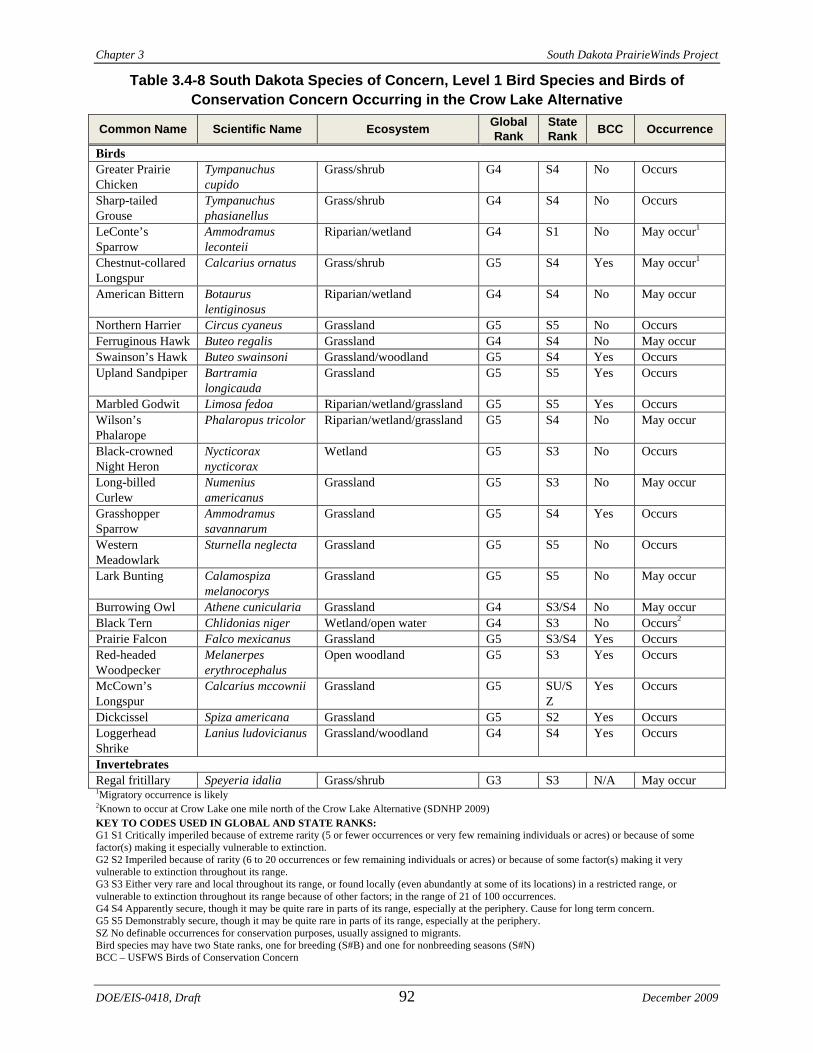
Chapter 3 South Dakota PrairieWinds Project
Table 3.4-8 South Dakota Species of Concern, Level 1 Bird Species and Birds of Conservation Concern Occurring in the Crow Lake Alternative
Common Name Scientific Name Ecosystem Global Rank
State Rank BCC Occurrence
Birds Greater Prairie Chicken
Tympanuchus cupido
Grass/shrub G4 S4 No Occurs
Sharp-tailed Grouse
Tympanuchus phasianellus
Grass/shrub G4 S4 No Occurs
LeConte’s Sparrow
Ammodramus leconteii
Riparian/wetland G4 S1 No May occur1
Chestnut-collared Longspur
Calcarius ornatus Grass/shrub G5 S4 Yes May occur1
American Bittern Botaurus lentiginosus
Riparian/wetland G4 S4 No May occur
Northern Harrier Circus cyaneus Grassland G5 S5 No Occurs Ferruginous Hawk Buteo regalis Grassland G4 S4 No May occur Swainson’s Hawk Buteo swainsoni Grassland/woodland G5 S4 Yes Occurs Upland Sandpiper Bartramia
longicauda Grassland G5 S5 Yes Occurs
Marbled Godwit Limosa fedoa Riparian/wetland/grassland G5 S5 Yes Occurs Wilson’s Phalarope
Phalaropus tricolor Riparian/wetland/grassland G5 S4 No May occur
Black-crowned Night Heron
Nycticorax nycticorax
Wetland G5 S3 No Occurs
Long-billed Curlew
Numenius americanus
Grassland G5 S3 No May occur
Grasshopper Sparrow
Ammodramus savannarum
Grassland G5 S4 Yes Occurs
Western Meadowlark
Sturnella neglecta Grassland G5 S5 No Occurs
Lark Bunting Calamospiza melanocorys
Grassland G5 S5 No May occur
Burrowing Owl Athene cunicularia Grassland G4 S3/S4 No May occur Black Tern Chlidonias niger Wetland/open water G4 S3 No Occurs2 Prairie Falcon Falco mexicanus Grassland G5 S3/S4 Yes Occurs Red-headed Woodpecker
Melanerpes erythrocephalus
Open woodland G5 S3 Yes Occurs
McCown’s Longspur
Calcarius mccownii Grassland G5 SU/SZ
Yes Occurs
Dickcissel Spiza americana Grassland G5 S2 Yes Occurs Loggerhead Shrike
Lanius ludovicianus Grassland/woodland G4 S4 Yes Occurs
Invertebrates Regal fritillary Speyeria idalia Grass/shrub G3 S3 N/A May occur 1Migratory occurrence is likely 2Known to occur at Crow Lake one mile north of the Crow Lake Alternative (SDNHP 2009) KEY TO CODES USED IN GLOBAL AND STATE RANKS: G1 S1 Critically imperiled because of extreme rarity (5 or fewer occurrences or very few remaining individuals or acres) or because of some factor(s) making it especially vulnerable to extinction. G2 S2 Imperiled because of rarity (6 to 20 occurrences or few remaining individuals or acres) or because of some factor(s) making it very vulnerable to extinction throughout its range. G3 S3 Either very rare and local throughout its range, or found locally (even abundantly at some of its locations) in a restricted range, or vulnerable to extinction throughout its range because of other factors; in the range of 21 of 100 occurrences. G4 S4 Apparently secure, though it may be quite rare in parts of its range, especially at the periphery. Cause for long term concern. G5 S5 Demonstrably secure, though it may be quite rare in parts of its range, especially at the periphery. SZ No definable occurrences for conservation purposes, usually assigned to migrants. Bird species may have two State ranks, one for breeding (S#B) and one for nonbreeding seasons (S#N) BCC – USFWS Birds of Conservation Concern
DOE/EIS-0418, Draft 92 December 2009
South Dakota PrairieWinds Project Chapter 3
Sharp-tailed Grouse
Sharp-tailed Grouse populations continue to decline, especially in grassland habitat. Sharp-tailed Grouse are year-round residents in the western portion of South Dakota. Breeding occurs throughout the State distribution and has been documented in northwestern Jerauld County (Huxoll 2005). Sharp-tailed Grouse were observed in the Crow Lake Alternative during 2009 aerial grouse lek surveys (WEST 2009a). Five grouse leks were found; one was confirmed Sharp-tailed Grouse.
Le Conte's Sparrow
Le Conte's Sparrows may be common within its range where suitable habitat is present. Le Conte's Sparrows are migratory residents in central South Dakota and summer residents in the northeastern portion of the State. Breeding has not been documented in Aurora, Brule or Jerauld counties (South Dakota Birds 2009). Le Conte's Sparrows were not observed in the Crow Lake Alternative during 2009 avian use surveys (WEST 2009a).
Chestnut-collared Longspur
Chestnut-collared Longspurs are common within their range where suitable habitat is present. Declining populations are generally local. Chestnut-collared Longspurs are summer residents in South Dakota. Breeding has been documented in northwest Jerauld County (South Dakota Birds 2009). Chestnut-collared Longspurs were observed in the Crow Lake Alternative during 2009 breeding bird surveys (WEST 2009a).
American Bittern
American Bittern populations continue to decline in wetland habitat, especially in the southern portion of its range. American bitterns are summer residents in South Dakota. Breeding has not been documented in Aurora, Brule or Jerauld counties, but has been documented in northeastern South Dakota (South Dakota Birds 2009). American Bitterns were not observed in the Crow Lake Alternative during 2009 breeding bird surveys (WEST 2009a).
Northern Harrier
Northern Harrier populations continue to decline primarily due to loss of wetland habitat and pesticide use within its range. Northern Harriers are summer residents of South Dakota and breed throughout the State. Breeding has not been documented in Aurora, Brule or Jerauld counties although it is probable (South Dakota Birds 2009). Northern Harriers were observed in the Crow Lake Alternative during spring 2009 migratory and breeding bird surveys (WEST 2009a).
Ferruginous Hawk
Ferruginous Hawks are summer residents of South Dakota and breed throughout much of the State. They occur in the northern half of the Eastern Prairie Ecoregion (the northern portion of the Crow Lake Alternative). However, breeding has not been documented in Aurora, Brule or
December 2009 93 DOE/EIS-0418, Draft
Chapter 3 South Dakota PrairieWinds Project
Jerauld counties (South Dakota Birds 2009). Ferruginous Hawks were not observed in the area during spring 2009 migratory and breeding bird surveys (WEST 2009a).
Swainson’s Hawk
Swainson’s Hawks are summer residents of South Dakota and breed throughout much of the State. Breeding has been documented in Brule and Aurora counties (South Dakota Birds 2009). Swainson’s Hawks were observed in the Crow Lake Alternative during spring 2009 migratory bird surveys (WEST 2009a).
Upland Sandpiper
Upland Sandpiper populations continue to decline primarily due to loss of wetland habitat and pesticide use. Upland Sandpipers are summer residents of South Dakota and breed throughout the State. However, breeding has not been documented in Aurora, Brule or Jerauld counties, although it is probable (South Dakota Birds 2009). Upland Sandpipers were observed in the Crow Lake Alternative during 2009 migratory and breeding bird surveys (WEST 2009a).
Marbled Godwit
Marbled Godwit populations continue to decline from historic levels primarily due to loss of wetland habitat within its range. Marbled Godwits are summer residents of South Dakota and breed throughout the State. Breeding has not been documented in Aurora, Brule or Jerauld counties (South Dakota Birds 2009). Marbled Godwits were observed in the Crow Lake Alternative during 2009 migratory and breeding bird surveys (WEST 2009a).
Wilson's Phalarope
Wilson's Phalarope populations continue to decline in local portions of its range due to loss of wetland habitat. Wilson's Phalaropes are summer residents of South Dakota and breed throughout the State. Breeding has not been documented in Aurora, Brule or Jerauld counties (South Dakota Birds 2009). Wilson's Phalarope was not observed in the Crow Lake Alternative during 2009 avian use surveys (WEST 2009a).
Black-crowned Night Heron
Black-crowned Night Heron threats include wetland loss and degradation, and pesticides that result in indirect adult mortality and direct mortality of eggs and young. Black-crowned Night Herons are summer residents of South Dakota and breed throughout the eastern part of the State. Breeding has been observed in Aurora and Jerauld counties (South Dakota Birds 2009). Black-crowned Night Herons were observed in the Crow Lake Alternative during spring 2009 migratory bird surveys (WEST 2009a).
DOE/EIS-0418, Draft 94 December 2009
South Dakota PrairieWinds Project Chapter 3
Long-billed Curlew
Long-billed Curlew threats include habitat loss, degradation and alteration, nest site disturbance, and pesticide/herbicide impacts (SDGFP 2006). Long-billed Curlews are summer residents of South Dakota and breed throughout the western part of the State. Breeding has not been observed east of the Missouri River or in Aurora, Brule and Jerauld counties (South Dakota Birds 2009). Long-billed Curlews were not observed in the Crow Lake Alternative during spring 2009 migratory bird surveys (WEST 2009a).
Grasshopper Sparrow
Grasshopper Sparrow populations continue to decline in local portions of its range due to loss of grassland habitat. Grasshopper Sparrows are summer residents of South Dakota and breed throughout the State. Breeding has not been documented in Aurora, Brule or Jerauld counties, although it is probable (South Dakota Birds 2009). Grasshopper Sparrows were observed in the Crow Lake Alternative during 2009 breeding bird surveys (WEST 2009a).
Western Meadowlark
Western Meadowlark populations are secure, and considered abundant and widespread. Local populations are monitored due to declines in grassland habitat. Western Meadowlarks are summer residents of South Dakota and breed throughout the State. Breeding has not been documented in Jerauld County but has been documented in Aurora and Brule counties (South Dakota Birds 2009). Western Meadowlarks were observed in the Crow Lake Alternative during 2009 breeding and migratory bird surveys (WEST 2009a).
Lark Bunting
Lark Bunting populations are secure, and considered abundant and widespread. Local populations are monitored due to declines in grassland habitat in South Dakota. Lark Buntings are summer residents throughout South Dakota and breed throughout the State. Breeding has not been documented in Aurora, Brule or Jerauld counties, although it is probable (South Dakota Birds 2009). Lark Buntings were not observed in the Crow Lake Alternative during 2009 breeding and migratory bird surveys (WEST 2009a).
Burrowing Owl
Burrowing Owl threats include habitat loss, degradation and alteration, nest depredation, vehicle collisions and illegal shooting (SDGFP 2006). Burrowing Owls are summer residents throughout South Dakota and mostly breed in the western two-thirds of the State. Breeding has not been documented in Aurora, Brule or Jerauld counties, although it is probable in Brule County (South Dakota Birds 2009). Burrowing Owls were not observed in the Crow Lake Alternative during 2009 breeding and migratory bird surveys (WEST 2009a); however, two prairie dog towns were observed along the northwest Crow Lake Alternative boundary. Burrowing Owls have been
December 2009 95 DOE/EIS-0418, Draft
Chapter 3 South Dakota PrairieWinds Project
shown to prefer active prairie dog towns; it has been suggested that large colonies are needed to maintain Burrowing Owl populations.
Black Tern
Black Terns are summer residents throughout South Dakota and breed throughout the State. Breeding has been documented in Aurora County and is probable in Jerauld County (South Dakota Birds 2009). According to the SDNHP database (2009) and the NRCS (1999), Black Terns occur at Crow Lake approximately one mile north of the Crow Lake Alternative (Figure 3.4-2). Black Terns were not observed in the area during 2009 breeding and migratory bird surveys (WEST 2009a).
Prairie Falcon
Prairie Falcons are permanent residents throughout South Dakota; however, some move short distances to the south for the winter. They are known to breed in the western portion of the State; breeding has not been documented in Aurora, Brule or Jerauld counties (South Dakota Birds 2009). Prairie Falcons were observed in the area during 2009 breeding and migratory bird surveys (WEST 2009a).
Red-headed Woodpecker
Red-headed Woodpeckers are permanent residents throughout South Dakota. They are known to breed statewide. Breeding has been documented in Jerauld County, is possible in Aurora County, and is probable in Brule County (South Dakota Birds 2009). Red-headed Woodpeckers were observed in the area during 2009 breeding and migratory bird surveys (WEST 2009a).
McCown’s Longspur
McCown’s Longspurs are summer residents throughout South Dakota. South Dakota is on the eastern edge of their major breeding grounds (Bakker 2005), and they are rare breeders in western South Dakota (South Dakota Birds 2009). Breeding is not likely in Aurora, Brule or Jerauld counties. McCown’s Longspurs were observed in the area during 2009 breeding and migratory bird surveys (WEST 2009a).
Dickcissel
Dickcissels are summer residents throughout South Dakota. Dickcissels preferred large grasslands in the mixed grass region of eastern South Dakota (Bakker 2005). Breeding is confirmed in Aurora and Brule counties, and is possible in Jerauld County (South Dakota Birds 2009). Dickcissels were observed in the area during 2009 breeding and migratory bird surveys (WEST 2009a).
DOE/EIS-0418, Draft 96 December 2009
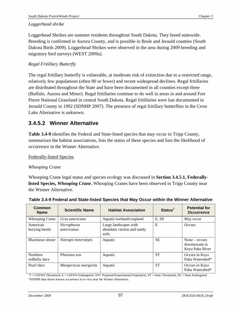
South Dakota PrairieWinds Project Chapter 3
Loggerhead shrike
Loggerhead Shrikes are summer residents throughout South Dakota. They breed statewide. Breeding is confirmed in Aurora County, and is possible in Brule and Jerauld counties (South Dakota Birds 2009). Loggerhead Shrikes were observed in the area during 2009 breeding and migratory bird surveys (WEST 2009a).
Regal Fritillary Butterfly
The regal fritillary butterfly is vulnerable, at moderate risk of extinction due to a restricted range, relatively few populations (often 80 or fewer) and recent widespread declines. Regal fritillaries are distributed throughout the State and have been documented in all counties except three (Buffalo, Aurora and Miner). Regal fritillaries continue to do well in areas in and around Fort Pierre National Grassland in central South Dakota. Regal fritillaries were last documented in Jerauld County in 1992 (SDNHP 2007). The presence of regal fritillary butterflies in the Crow Lake Alternative is unknown.
3.4.5.2 Winner Alternative
Table 3.4-9 identifies the Federal and State-listed species that may occur in Tripp County, summarizes the habitat associations, lists the status of these species and lists the likelihood of occurrence in the Winner Alternative.
Federally-listed Species
Whooping Crane
Whooping Crane legal status and species ecology was discussed in Section 3.4.5.1, Federally-listed Species, Whooping Crane. Whooping Cranes have been observed in Tripp County near the Winner Alternative.
Table 3.4-9 Federal and State-listed Species that May Occur within the Winner Alternative
Common Name Scientific Name Habitat Association Status1 Potential for
Occurrence Whooping Crane Grus americana Aquatic/wetland/cropland E, SE May occur American burying beetle
Nicrophorus americanus
Large landscapes with abundant carrion and sandy soils
E Occurs
Blacknose shiner Notropis heterolepis Aquatic SE None – occurs downstream in Keya Paha River
Northern redbelly dace
Phoxinus eos Aquatic ST Occurs in Keya Paha Watershed*
Pearl dace Margariscus margarita Aquatic ST Occurs in Keya Paha Watershed*
1T = USFWS Threatened, E = USFWS Endangered, XN= Proposed/Experimental Population, ST = State Threatened, SE = State Endangered *SDNHP data shows known occurrence in or very near the Winner Alternative.
December 2009 97 DOE/EIS-0418, Draft
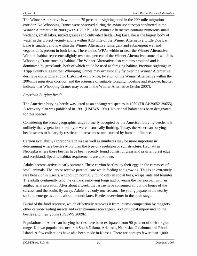
Chapter 3 South Dakota PrairieWinds Project
The Winner Alternative is within the 75 percentile sighting band in the 200-mile migration corridor. No Whooping Cranes were observed during the avian use surveys conducted in the Winner Alternative in 2009 (WEST 2009b). The Winner Alternative contains numerous small wetlands, small lakes, mixed grasses and cultivated fields. Dog Ear Lake is the largest body of water in the project vicinity and is within 0.25 mile of the Winner Alternative. Little Dog Ear Lake is smaller, and is within the Winner Alternative. Emergent and submergent wetland vegetation is present in both lakes. There are no WPAs within or near the Winner Alternative. Wetland habitat represents slightly over one percent of the Winner Alternative, some of which is Whooping Crane roosting habitat. The Winner Alternative also contains cropland and is dominated by grasslands, both of which could be used as foraging habitat. Previous sightings in Tripp County suggest that Whooping Cranes may occasionally fly over the Winner Alternative during seasonal migrations. Historical occurrence, location of the Winner Alternative within the 200-mile migration corridor, and the presence of suitable foraging, roosting and stopover habitat indicate that Whooping Cranes may occur in the Winner Alternative (Stehn 2007).
American Burying Beetle
The American burying beetle was listed as an endangered species in 1989 (FR 54:29652-29655). A recovery plan was published in 1991 (USFWS 1991). No critical habitat has been designated for this species.
Considering the broad geographic range formerly occupied by the American burying beetle, it is unlikely that vegetation or soil type were historically limiting. Today, the American burying beetle seems to be largely restricted to areas most undisturbed by human influence.
Carrion availability (appropriate in size as well as numbers) may be more important in determining where beetles occur than the type of vegetation or soil structure. Habitats in Nebraska where these beetles have been recently found consist of grassland prairie, forest edge and scrubland. Specific habitat requirements are unknown.
Adults become active in early summer. These carrion beetles lay their eggs in the carcasses of small animals. The larvae receive parental care while feeding and growing. This is an extremely rare behavior in insects, a condition normally found only in social bees, wasps, ants and termites. The adults continually tend the carcass, removing fungi and covering the carrion ball with an antibacterial secretion. After about a week, the larvae have consumed all but the bones of the carcass, and the adults fly away. Adults live only one season. The young pupate in the nearby soil and emerge as adults about a month later. Beetles overwinter in the adult stage.
Burial of the food resource, which effectively removes it from intense competition by maggots, other carrion-feeding insects and even mammal scavengers, is of principal importance to the beetles and their young (USFWS 2009b).
Populations of American burying beetles have been extirpated from 90 percent of their original range. Known populations occur in South Dakota, Arkansas, Nebraska, Oklahoma and Rhode Island. A few collections have also been made in Kansas. There are perhaps fewer than 1,000
DOE/EIS-0418, Draft 98 December 2009

South Dakota PrairieWinds Project Chapter 3
individuals in the only remaining population east of the Mississippi River, and the Oklahoma, Arkansas and South Dakota populations (currently being inventoried) are of uncertain size. South Dakota estimates over 500 square miles of occupied habitat with a high population density. American burying beetles have been documented in South Dakota in numerous locations in Tripp County between 1995 and 2003, including in the Winner Alternative (SDGFP 2009e).
State-Listed Species
Whooping Crane
The legal status and species ecology of Whooping Cranes are discussed in Section 3.4.5.1, Federally-listed Species, Whooping Crane. The local distribution of Whooping Cranes is discussed above.
Blacknose Shiner
Blacknose shiner is listed by the State as endangered. The species is an important indicator of high water quality and pristine streams. It is known to occur in southern Tripp County in the Keya Paha watershed (SDGFP 2006).
Northern Redbelly Dace
Northern redbelly dace is listed by the State as threatened. This species is widespread in the northern United States and Canada in boggy lakes, creeks and ponds. It is often found in tea-colored, slightly acidic water. It is found in the Big Sioux, Minnesota, Niobrara and Crow Creek drainages in South Dakota. Northern redbelly dace are known to occur in the Keya Paha watershed within one mile of the Winner Alternative (SDNHP 2009).
Pearl Dace
Pearl dace is listed by the State as threatened. It occurs in southern Tripp County in the Keya Paha watershed (SDGFP 2006) and has been documented within one mile of the Winner Alternative (SDNHP 2009).
State and Federal Species of Concern
State species of concern that may occur in the Winner Alternative are listed in Table 3.4-10. In addition to those species, South Dakota maintains a list of Level 1 priority bird species, and the USFWS maintains the BCC list (Table 3.4-10).
December 2009 99 DOE/EIS-0418, Draft

Chapter 3 South Dakota PrairieWinds Project
Table 3.4-10 South Dakota Species of Concern, Level 1 Bird Species and Birds of Conservation Concern Occurring in the Winner Alternative
Common Name Scientific Name Ecosystem Global
Rank State Rank BCC Occurrence
Birds Greater Prairie Chicken
Tympanuchus cupido
Grass/shrub G4 S4 No Occurs
Sharp-tailed Grouse
Tympanuchus phasianellus
Grass/shrub G4 S4 No Occurs
Chestnut-collared Longspur
Calcarius ornatus Grass/shrub G5 S4 Yes Occurs
American Bittern Botaurus lentiginosus
Riparian/wetland G4 S4 No May occur
Northern Harrier Circus cyaneus Grassland G5 S5 No Occurs Ferruginous Hawk
Buteo regalis Grassland G4 S4 Yes Occurs
Swainson’s Hawk
Buteo swainsoni Grassland/woodland G5 S4 No Occurs
Upland Sandpiper
Bartramia longicauda
Grassland G5 S5 Yes Occurs
Marbled Godwit Limosa fedoa Riparian/wetland/ grassland
G5 S5 Yes Occurs
Wilson’s Phalarope
Phalaropus tricolor
Riparian/wetland/ grassland
G5 S4 No Occurs
Long-billed Curlew
Numenius americanus
Grassland G5 S3 No Occurs*
Grasshopper Sparrow
Ammodramus savannarum
Grassland G5 S4 Yes Occurs
Western Meadowlark
Sturnella neglecta Grassland G5 S5 No Occurs
Lark Bunting Calamospiza melanocorys
Grassland G5 S5 No May occur
Orchard Oriole Icterus spurious Grassland/woodland No Occurs Burrowing Owl Athene cunicularia Grassland G4 S3/S4 Yes Occurs Black Tern Chlidonias niger Wetland/open water G4 S3B/
SZN No May occur
Trumpeter Swan Cygnus buccinator Aquatic/wetland G4 S3 No May occur* American White Pelican
Pelecanus erythrorhynchos
Aquatic G3 S3B/ SZN
No Occurs*
Prairie Falcon Falco mexicanus Grassland G5 S3/S4 Yes Occurs Red-headed Woodpecker
Melanerpes erythrocephalus
Open Woodland G5 S3 Yes Occurs
Loggerhead Shrike
Lanius ludovicianus
Grassland/woodland G4 S4 Yes Occurs
Dickcissel Spiza americana Grassland G5 S2 Yes Occurs Mammals Plains spotted skunk
Spilogale putorius interrupta
Grassland G5 S3 N/A Occurs*
Fish Plains topminnow
Fundulus sciadicus
Aquatic G4 S3 N/A Occurs*
DOE/EIS-0418, Draft 100 December 2009
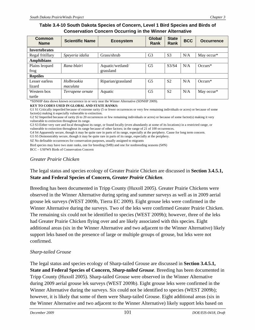
South Dakota PrairieWinds Project Chapter 3
December 2009 101 DOE/EIS-0418, Draft
Table 3.4-10 South Dakota Species of Concern, Level 1 Bird Species and Birds of Conservation Concern Occurring in the Winner Alternative
Common Name Scientific Name Ecosystem Global
Rank State Rank BCC Occurrence
Invertebrates Regal fritillary Speyeria idalia Grass/shrub G3 S3 N/A May occur* Amphibians Plains leopard frog
Rana blairi Aquatic/wetland/ grassland
G5 S3/S4 N/A Occurs*
Reptiles Lesser earless lizard
Holbrookia maculata
Riparian/grassland G5 S2 N/A Occurs*
Western box turtle
Terrapene ornate Aquatic G5 S2 N/A May occur*
*SDNHP data shows known occurrence in or very near the Winner Alternative (SDNHP 2009). KEY TO CODES USED IN GLOBAL AND STATE RANKS: G1 S1 Critically imperiled because of extreme rarity (5 or fewer occurrences or very few remaining individuals or acres) or because of some factor(s) making it especially vulnerable to extinction. G2 S2 Imperiled because of rarity (6 to 20 occurrences or few remaining individuals or acres) or because of some factor(s) making it very vulnerable to extinction throughout its range. G3 S3 Either very rare and local throughout its range, or found locally (even abundantly at some of its locations) in a restricted range, or vulnerable to extinction throughout its range because of other factors; in the range of 21 of 100 occurrences. G4 S4 Apparently secure, though it may be quite rare in parts of its range, especially at the periphery. Cause for long term concern. G5 S5 Demonstrably secure, though it may be quite rare in parts of its range, especially at the periphery. SZ No definable occurrences for conservation purposes, usually assigned to migrants Bird species may have two state ranks, one for breeding (S#B) and one for nonbreeding seasons (S#N) BCC – USFWS Birds of Conservation Concern
Greater Prairie Chicken
The legal status and species ecology of Greater Prairie Chicken are discussed in Section 3.4.5.1, State and Federal Species of Concern, Greater Prairie Chicken.
Breeding has been documented in Tripp County (Huxoll 2005). Greater Prairie Chickens were observed in the Winner Alternative during spring and summer surveys as well as in 2009 aerial grouse lek surveys (WEST 2009b, Tierra EC 2009). Eight grouse leks were confirmed in the Winner Alternative during the surveys. Two of the leks were confirmed Greater Prairie Chicken. The remaining six could not be identified to species (WEST 2009b); however, three of the leks had Greater Prairie Chicken flying over and are likely associated with this species. Eight additional areas (six in the Winner Alternative and two adjacent to the Winner Alternative) likely support leks based on the presence of large or multiple groups of grouse, but leks were not confirmed.
Sharp-tailed Grouse
The legal status and species ecology of Sharp-tailed Grouse are discussed in Section 3.4.5.1, State and Federal Species of Concern, Sharp-tailed Grouse. Breeding has been documented in Tripp County (Huxoll 2005). Sharp-tailed Grouse were observed in the Winner Alternative during 2009 aerial grouse lek surveys (WEST 2009b). Eight grouse leks were confirmed in the Winner Alternative during the surveys. Six could not be identified to species (WEST 2009b); however, it is likely that some of them were Sharp-tailed Grouse. Eight additional areas (six in the Winner Alternative and two adjacent to the Winner Alternative) likely support leks based on
Chapter 3 South Dakota PrairieWinds Project
the presence of large or multiple groups of grouse, but leks were not confirmed. Three of these had Sharp-tailed Grouse.
Chestnut-collared Longspur
The legal status and species ecology of Chestnut-collared Longspur are discussed in Section 3.4.5.1, State and Federal Species of Concern, Chestnut-collared Longspur. Chestnut-collared Longspur breeding has been documented in southern Tripp County (South Dakota Birds 2009). Chestnut-collared Longspurs were observed in the Winner Alternative during 2009 breeding bird surveys (WEST 2009b).
American Bittern
The legal status and species ecology of American Bittern are discussed in Section 3.4.5.1, State and Federal Species of Concern, American Bittern. Breeding has not been documented in Tripp County, but it is possible (South Dakota Birds 2009). American Bitterns were not observed in the Winner Alternative during 2009 breeding bird surveys (WEST 2009b).
Northern Harrier
The legal status and species ecology of Northern Harrier are discussed in Section 3.4.5.1, State and Federal Species of Concern, Northern Harrier. Breeding has not been documented in Tripp County although it is possible (South Dakota Birds 2009). Northern Harriers were observed in the Winner Alternative during spring 2009 migratory bird surveys (WEST 2009b).
Ferruginous Hawk
The legal status and species ecology of Ferruginous Hawk are discussed in Section 3.4.5.1, State and Federal Species of Concern, Ferruginous Hawk. Breeding has not been documented in Tripp County, although it is probable (South Dakota Birds 2009). Ferruginous Hawks were observed in the Winner Alternative during spring 2009 avian use surveys (WEST 2009b).
Swainson’s Hawk
The legal status and species ecology of Swainson’s Hawk are discussed in Section 3.4.5.1, State and Federal Species of Concern, Swainson’s Hawk. Breeding has been documented in Tripp County, although it is probable (South Dakota Birds 2009). Swainson’s Hawks were observed in the Winner Alternative during spring 2009 migratory bird surveys (WEST 2009b).
Upland Sandpiper
The legal status and species ecology of Upland Sandpiper are discussed in Section 3.4.5.1, State and Federal Species of Concern, Upland Sandpiper. Breeding has not been documented in Tripp County, although it is probable (South Dakota Birds 2009). Upland Sandpipers were observed in the Winner Alternative during 2009 migratory and breeding bird surveys (WEST 2009b).
DOE/EIS-0418, Draft 102 December 2009
South Dakota PrairieWinds Project Chapter 3
Marbled Godwit
The legal status and species ecology of Marbled Godwit are discussed in Section 3.4.5.1, State and Federal Species of Concern, Marbled Godwit. Breeding has not been documented in Tripp County (South Dakota Birds 2009). Marbled Godwits were observed in the Winner Alternative during 2009 migratory bird surveys (WEST 2009b).
Wilson's Phalarope
The legal status and species ecology of Wilson’s Phalarope are discussed in Section 3.4.5.1, State and Federal Species of Concern, Wilson’s Phalarope. Breeding has not been documented in Tripp County, although it is probable (South Dakota Birds 2009). Wilson's Phalarope was observed in the Winner Alternative during 2009 breeding bird surveys (WEST 2009b).
Long-billed Curlew
The legal status and species ecology of Long-billed Curlew are discussed in Section 3.4.5.1, State and Federal Species of Concern, Long-billed Curlew. Breeding has been confirmed in southern Tripp County (South Dakota Birds 2009). Long-billed Curlews were not observed in the Winner Alternative during spring 2009 avian use surveys (WEST 2009b).
Grasshopper Sparrow
The legal status and species ecology of Grasshopper Sparrow are discussed in Section 3.4.5.1, State and Federal Species of Concern, Grasshopper Sparrow. Breeding has not been documented in Tripp County, although it is possible (South Dakota Birds 2009). Grasshopper Sparrows were observed in the Winner Alternative during 2009 breeding bird surveys (WEST 2009b).
Western Meadowlark
The legal status and species ecology of Western Meadowlark are discussed in Section 3.4.5.1, State and Federal Species of Concern, Western Meadowlark. Breeding has been documented in Tripp County (South Dakota Birds 2009). Western Meadowlarks were observed in the Winner Alternative during 2009 breeding and migratory bird surveys (WEST 2009b).
Lark Bunting
The legal status and species ecology of Lark Bunting are discussed in Section 3.4.5.1, State and Federal Species of Concern, Lark Bunting. Breeding has not been documented in Tripp County, although it is probable (South Dakota Birds 2009). Lark Buntings were not observed in the Winner Alternative during 2009 breeding and migratory bird surveys (WEST 2009b).
December 2009 103 DOE/EIS-0418, Draft
Chapter 3 South Dakota PrairieWinds Project
Orchard Oriole
Orchard Oriole is a common summer resident throughout much of South Dakota. Breeding has not been documented in Tripp, although it is probable (South Dakota Birds 2009). Orchard Orioles were observed in the Winner Alternative during 2009 breeding bird surveys (WEST 2009b).
Burrowing Owl
The legal status and species ecology of Burrowing Owl are discussed in Section 3.4.5.1, State and Federal Species of Concern, Burrowing Owl. Breeding has not been documented in Tripp County (South Dakota Birds 2009). Burrowing Owls were observed in the Winner Alternative during 2009 avian use surveys (WEST 2009b). There are two known prairie dog towns in the Winner Alternative that are suitable Burrowing Owl habitat: one in the west portion and one in the southeast portion.
Black Tern
The legal status and species ecology of Black Tern are discussed in Section 3.4.5.1, State and Federal Species of Concern, Black Tern. Breeding has been observed in Tripp County (South Dakota Birds 2009). Black Terns were not observed in the Winner Alternative during 2009 breeding and migratory bird surveys (WEST 2009b).
Trumpeter Swan
Trumpeter Swan threats include habitat loss, degradation and alteration resulting in the reduction of shallow areas, reduction in beaver ponds, irregular managed water flows, nest site disturbance, pesticide impacts, lead poisoning and illegal shooting (SDGFP 2006). Trumpeter Swans are summer residents in the western half of South Dakota; very little breeding is known in the State. Breeding has not been confirmed in Tripp County, although it is probable in southern Tripp County (South Dakota Birds 2009). Trumpeter Swans were not observed in the Winner Alternative during 2009 breeding and migratory bird surveys (WEST 2009b); however, they are known to occur at several lakes in and near the Winner Alternative, including Little Dog Ear Lake and Dog Ear Lake (SDNHP 2009).
American White Pelican
American White Pelican threats include habitat loss, degradation and alteration resulting in the reduction of shallow areas, irregular managed water flows, nest site disturbance and pesticide impacts (SDGFP 2009).
American White Pelicans are mostly migratory through South Dakota, although summer residents have been documented in northeastern South Dakota; very little breeding is known in the State (SDGFP 2006). Breeding has been observed but not confirmed in northwestern Tripp County (South Dakota Birds 2009). American White Pelicans were observed in the Winner Alternative during 2009 breeding and migratory bird surveys (WEST 2009b).
DOE/EIS-0418, Draft 104 December 2009
South Dakota PrairieWinds Project Chapter 3
Prairie Falcon
The legal status and species ecology of Prairie Falcon are discussed in Section 3.4.5.1, State and Federal Species of Concern, Prairie Falcon. Breeding has not been documented in Tripp County (South Dakota Birds 2009). Prairie Falcons were observed in the Winner Alternative during 2009 breeding bird surveys (WEST 2009b).
Red-headed Woodpecker
The legal status and species ecology of Red-headed Woodpecker are discussed in Section 3.4.5.1, State and Federal Species of Concern, Red-headed Woodpecker. Breeding has been documented in Tripp County (South Dakota Birds 2009). Red-headed Woodpeckers were observed in the Winner Alternative during 2009 breeding bird surveys (WEST 2009b).
Dickcissel
The legal status and species ecology of Dickcissel are discussed in Section 3.4.5.1, State and Federal Species of Concern, Dickcissel. Breeding has been documented in Tripp County (South Dakota Birds 2009). Dickcissels were observed in the Winner Alternative during 2009 breeding bird surveys (WEST 2009b).
Loggerhead Shrike
The legal status and species ecology of Loggerhead Shrike are discussed in Section 3.4.5.1, State and Federal Species of Concern, Loggerhead Shrike. Breeding has not been documented in Tripp County but USGS indicates it is possible (South Dakota Birds 2009). Loggerhead Shrikes were observed in the Winner Alternative during 2009 breeding bird surveys (WEST 2009b).
Plains Spotted Skunk
The plains spotted skunk was formerly common but their populations began declining in the mid-1900s. The decrease may be related to the changes in agriculture that stressed clean farming, thereby leaving little cover for skunks. It also is possible that increased pesticide use in agricultural areas has affected insect abundance, which skunks commonly eat.
Plains spotted skunk is known to occur in the northern portion of the Winner Alternative just south of Winner (SDNHP 2009).
Plains Topminnow
The plains topminnow has a limited range, with eastern South Dakota forming the upper, western edge. The plains topminnow is threatened by any activity causing alteration of its habitat, particularly groundwater withdrawal and drainage of wetlands (SDGFP 2009d).
The plains topminnow has a limited range within the Missouri River drainage, from eastern Wyoming to southwestern Minnesota and northwestern Iowa. The plains topminnow occurs in
December 2009 105 DOE/EIS-0418, Draft
Chapter 3 South Dakota PrairieWinds Project
the James, Vermillion and Big Sioux river basins in eastern South Dakota. It is most common in the James River basin where it occurs in several tributaries, as well as backwater pools and ponds. It is present west of the Winner Alternative in the Keya Paha watershed (SDNHP 2009).
Plains Leopard Frog
Plains leopard frogs occur in the vicinity of streams, natural and artificial ponds, reservoirs, creek pools, irrigation ditches and other bodies of water in plains grassland, sand hills, stream valleys and canyon bottoms. Plains leopard frogs may disperse far from water during wet, mild weather. Plains leopard frogs are known to occur in the northern portion of the Winner Alternative, approximately 5 miles south of Winner (SDNHP 2009).
Lesser Earless Lizard
Lesser earless lizard threats include habitat loss or degradation due to stabilization of sand dunes and loss of habitat from land conversion by agriculture and urban development (SDGFP 2006). Lesser earless lizards are known to occur in southern Tripp County, including the Winner Alternative (Figure 3.4-2) (SDGFP 2006; SDNHP 2009). This lizard prefers sand hills, sandy or gravelly areas along streams, sparsely vegetated or short grass ecosystems, and prairie dog towns (SDGFP 2006).
Western Box Turtle
Western box turtle threats include habitat loss or degradation due to stream channelization and impoundment, water pollution, removal of basking sites (large woody debris) and lack of nesting sites such as sandbars (SDGFP 2006). Western box turtles occur in southern Tripp County, including the Winner Alternative (Figure 3.4-4) (SDGFP 2006; SDNHP 2009).
Regal Fritillary Butterfly
The legal status and species ecology of Regal Fritillary are discussed in Section 3.4.5.1, State and Federal Species of Concern, Regal Fritillary Butterfly. Regal fritillaries are distributed throughout the State and have been documented in all counties except three (Buffalo, Aurora and Miner). The presence of regal fritillary butterflies in the Winner Alternative is unknown, although there is a documented occurrence five miles south of the Winner Alternative (SDNHP 2009).
3.5 CULTURAL RESOURCES A cultural resource is an all-encompassing term for an archaeological, historical or Native American resource. They are sites, structures, landscapes and objects of some importance to a culture or community for scientific, traditional, religious or other reasons. They are the materials and built features left from past human activities that are studied to reconstruct past human behavior and actions. Native American resources include but are not limited to Traditional Cultural Properties (TCPs). A TCP is a resource that is eligible for inclusion in the NRHP
DOE/EIS-0418, Draft 106 December 2009
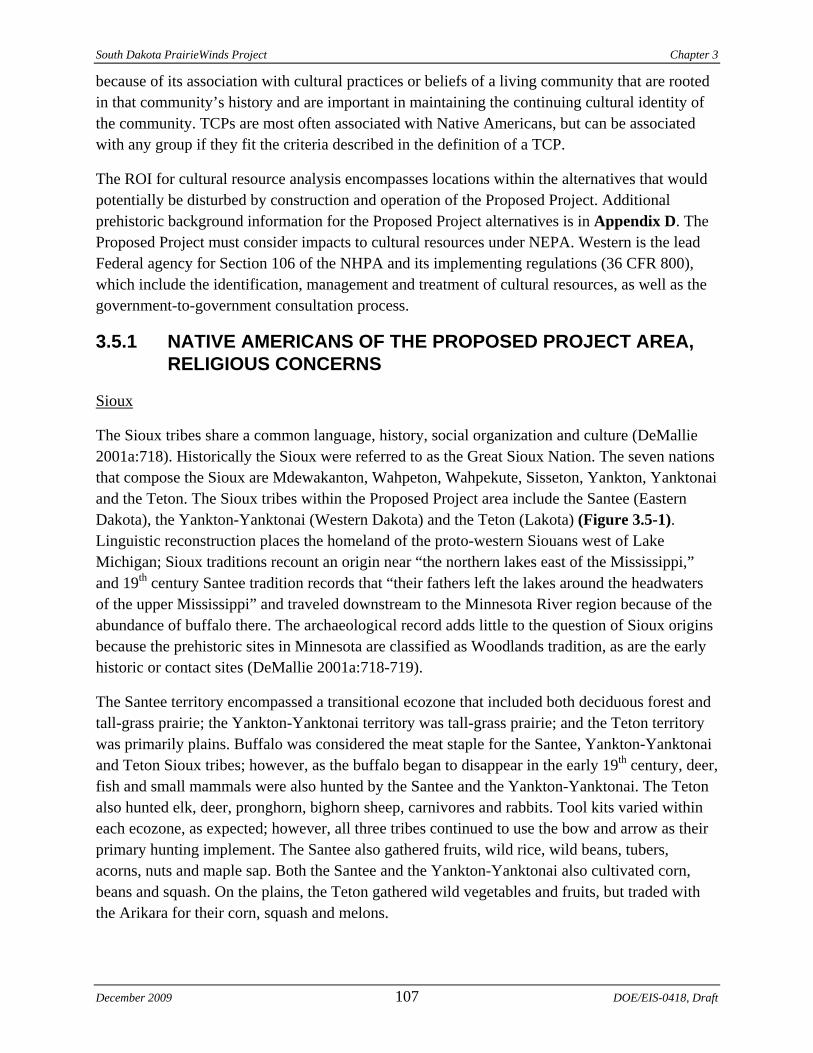
South Dakota PrairieWinds Project Chapter 3
because of its association with cultural practices or beliefs of a living community that are rooted in that community’s history and are important in maintaining the continuing cultural identity of the community. TCPs are most often associated with Native Americans, but can be associated with any group if they fit the criteria described in the definition of a TCP.
The ROI for cultural resource analysis encompasses locations within the alternatives that would potentially be disturbed by construction and operation of the Proposed Project. Additional prehistoric background information for the Proposed Project alternatives is in Appendix D. The Proposed Project must consider impacts to cultural resources under NEPA. Western is the lead Federal agency for Section 106 of the NHPA and its implementing regulations (36 CFR 800), which include the identification, management and treatment of cultural resources, as well as the government-to-government consultation process.
3.5.1 NATIVE AMERICANS OF THE PROPOSED PROJECT AREA, RELIGIOUS CONCERNS
Sioux
The Sioux tribes share a common language, history, social organization and culture (DeMallie 2001a:718). Historically the Sioux were referred to as the Great Sioux Nation. The seven nations that compose the Sioux are Mdewakanton, Wahpeton, Wahpekute, Sisseton, Yankton, Yanktonai and the Teton. The Sioux tribes within the Proposed Project area include the Santee (Eastern Dakota), the Yankton-Yanktonai (Western Dakota) and the Teton (Lakota) (Figure 3.5-1). Linguistic reconstruction places the homeland of the proto-western Siouans west of Lake Michigan; Sioux traditions recount an origin near “the northern lakes east of the Mississippi,” and 19th century Santee tradition records that “their fathers left the lakes around the headwaters of the upper Mississippi” and traveled downstream to the Minnesota River region because of the abundance of buffalo there. The archaeological record adds little to the question of Sioux origins because the prehistoric sites in Minnesota are classified as Woodlands tradition, as are the early historic or contact sites (DeMallie 2001a:718-719).
The Santee territory encompassed a transitional ecozone that included both deciduous forest and tall-grass prairie; the Yankton-Yanktonai territory was tall-grass prairie; and the Teton territory was primarily plains. Buffalo was considered the meat staple for the Santee, Yankton-Yanktonai and Teton Sioux tribes; however, as the buffalo began to disappear in the early 19th century, deer, fish and small mammals were also hunted by the Santee and the Yankton-Yanktonai. The Teton also hunted elk, deer, pronghorn, bighorn sheep, carnivores and rabbits. Tool kits varied within each ecozone, as expected; however, all three tribes continued to use the bow and arrow as their primary hunting implement. The Santee also gathered fruits, wild rice, wild beans, tubers, acorns, nuts and maple sap. Both the Santee and the Yankton-Yanktonai also cultivated corn, beans and squash. On the plains, the Teton gathered wild vegetables and fruits, but traded with the Arikara for their corn, squash and melons.
December 2009 107 DOE/EIS-0418, Draft
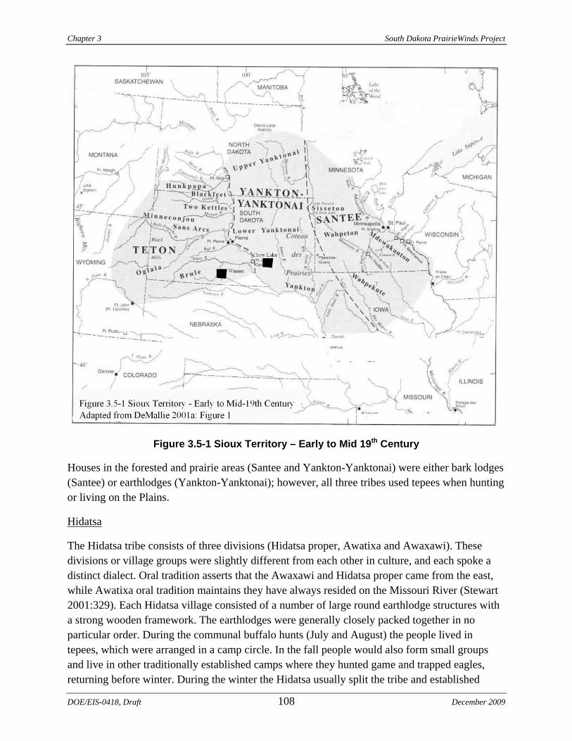
Chapter 3 South Dakota PrairieWinds Project
Figure 3.5-1 Sioux Territory – Early to Mid 19th Century
Houses in the forested and prairie areas (Santee and Yankton-Yanktonai) were either bark lodges (Santee) or earthlodges (Yankton-Yanktonai); however, all three tribes used tepees when hunting or living on the Plains.
Hidatsa
The Hidatsa tribe consists of three divisions (Hidatsa proper, Awatixa and Awaxawi). These divisions or village groups were slightly different from each other in culture, and each spoke a distinct dialect. Oral tradition asserts that the Awaxawi and Hidatsa proper came from the east, while Awatixa oral tradition maintains they have always resided on the Missouri River (Stewart 2001:329). Each Hidatsa village consisted of a number of large round earthlodge structures with a strong wooden framework. The earthlodges were generally closely packed together in no particular order. During the communal buffalo hunts (July and August) the people lived in tepees, which were arranged in a camp circle. In the fall people would also form small groups and live in other traditionally established camps where they hunted game and trapped eagles, returning before winter. During the winter the Hidatsa usually split the tribe and established
DOE/EIS-0418, Draft 108 December 2009
South Dakota PrairieWinds Project Chapter 3
winter camps several miles away from the summer camp. Subsistence for the Hidatsa consisted of buffalo and other large game, fish, corn, sunflower and wild fruits and vegetables.
Mandan
The Mandan lived in villages on the middle Missouri River and lived a lifestyle that combined horticulture and buffalo hunting. By the early 1700s they had well established fortified villages on both sides of the Missouri River near the mouth of the Heart River, likely due to aggressive pressure from other villages and nomadic tribes from the central Plains (Wood and Irwin 2001:349). The Mandan sphere of influence also included a large area to the west that they used in the fall on annual bison hunts and eagle-trapping expeditions. Mandan village locations were chosen for defense. The villages were built on high terraces overlooking the Missouri River floodplain and their gardens were planted in the floodplains. Their earthlodges were arranged around a plaza, which might be located at the edge of the village or at the center. During the winter, the main village was abandoned and temporary villages were established with smaller earthlodges. Subsistence consisted of bison, deer, antelope, elk, small game, waterfowl, fish, corn, beans, squash and sunflowers.
Arikara
The Arikara are the northernmost member of the Caddoan language family, and are considered a divergent dialect of Pawnee (Parks 2001:365). Devastating smallpox epidemics during the late 18th century forced the Arikara to consolidate into two major villages in the area of the Cheyenne and Missouri Rivers in South Dakota. Over the next century they continued to move north along the Missouri River ending up eventually on the Fort Berthold Reservation in North Dakota in 1862.
Prior to the time of the epidemics the Arikara engaged in large communal buffalo hunts that probably extended westward onto the plains. It is believed that during the historic period the pressures of population loss and warfare caused them to concentrate their subsistence practices on horticulture and trading within the vicinity of their villages. Villages were placed on high terraces overlooking the Missouri River and contained between 30 to several hundred lodges, surrounded by a ditch and earthen embankment (Parks 2001:368).
The Arikara buried their deceased on the prairie beyond the village in mounded graves. These village cemeteries were often one mile in length. The Arikara occasionally placed shrines outside the village on the prairie. During the fall the Arikara left the permanent village and established a smaller, identical village in the bottomlands of the Missouri River for the winter months. The people lived in tepees during the communal buffalo hunts. Subsistence practices consisted of hunting and fishing. Buffalo were the most important game animal; however, other important sources of meat included antelope, deer, elk, smaller prey and fish. Corn was the most important crop, with as many as 11 varieties being grown. Beans, squash, melons, sunflower and tobacco were also grown. Wild plants and fruits were also gathered.
December 2009 109 DOE/EIS-0418, Draft
Chapter 3 South Dakota PrairieWinds Project
Religious Concerns
The Santee, Yankton-Yanktonai and Teton Sioux tribes, like most Native people, lived their lives with ceremony. Ethnographic accounts of the Sioux tribes suggest that the Proposed Project area may contain sensitive sites where sweatlodge, Sun Dance, vision quests, ritual fasting, life cycle events including surface remains or secondary pit burials, or eagle trapping ceremonies occurred (Albers 2001:768-769; DeMallie 2001b:789-790; DeMallie 2001c:806-808).
Likewise for the Hidatsa, Mandan and Arikara, ceremony was an important part of their lives, especially the “bundles” and associated ceremonies that were an integral part of their tribal and personal identity. The Hidatsa and the Mandan had dance ceremonies similar to the Sun Dance, and the Arikara also had the Sun Dance. All had the eagle-trapping ceremony as well. The Arikara also placed altars outside their villages on the prairie and constructed village cemeteries in the form of mounds also outside the villages (DeMallie 2001b; Parks 2001: 379-383; Stewart 2001:335-337; Wood and Irwin 2001:357-359).
Archaeologists are able to record the material remains of these sites; however, the religious or cultural significance of these types of sites, if encountered, can only be determined by the tribes.
Federal Responsibilities
Western is the lead Federal agency for the Section 106 process of the NHPA for the Proposed Project. To date, the Agencies have participated in three government- to-government meetings with the tribes on June 24, 2009, August 5, 2009, and September 29, 2009, to discuss the Proposed Project and tribal concerns. Based on the consultation meetings with Native American tribes the following concerns were identified:
• The need for Native American monitors during pedestrian surveys • The need for a TCP survey that would include tribal elders and other tribal
representatives • The need for cultural sensitivity training for the construction crew • The potential for historical significance and concerns in the area surrounding the Winner
Alternative
Following the government–to-government consultation meetings, a record search was conducted by the Rosebud Sioux Tribe Historic Preservation Office in August 2009 for the Winner Alternative. The results indicated that there was no TCPs recorded in the tribe’s database within the Proposed Project area. However, it is the view of the tribe that this does not preclude the possibility of archaeological sites being present within the Proposed Project area (Appendix D).
A TCP study is proposed and will be conducted by consulting tribes prior to construction.
3.5.2 PREVIOUS RESEARCH
The Class I inventory included a review of existing cultural resources documentation on file in State repositories, a preliminary architectural history windshield survey within the Proposed
DOE/EIS-0418, Draft 110 December 2009
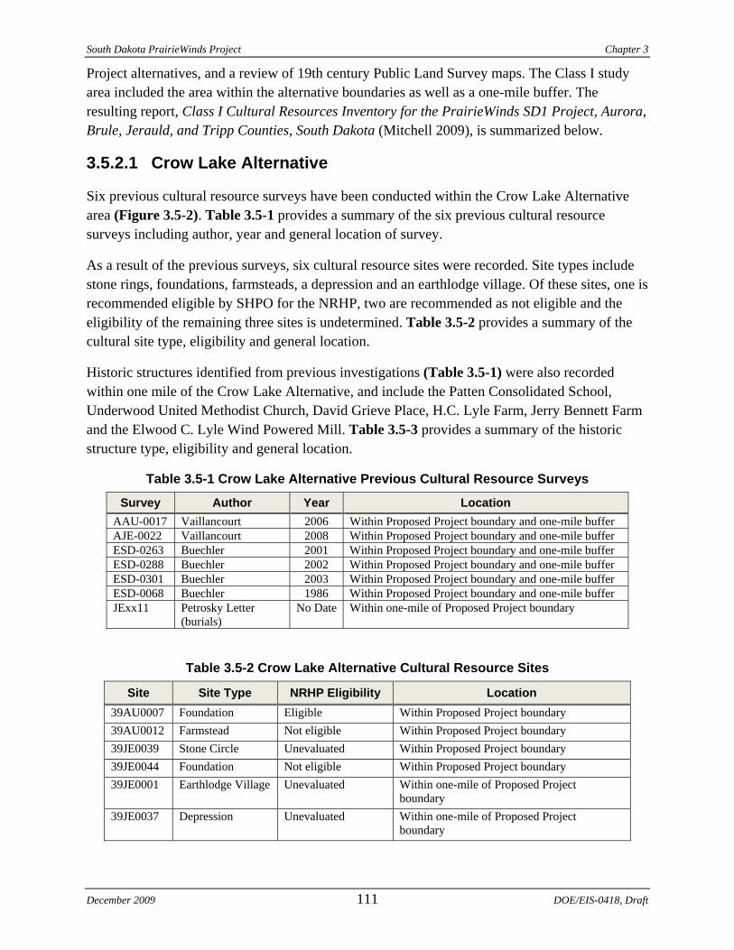
South Dakota PrairieWinds Project Chapter 3
Project alternatives, and a review of 19th century Public Land Survey maps. The Class I study area included the area within the alternative boundaries as well as a one-mile buffer. The resulting report, Class I Cultural Resources Inventory for the PrairieWinds SD1 Project, Aurora, Brule, Jerauld, and Tripp Counties, South Dakota (Mitchell 2009), is summarized below.
3.5.2.1 Crow Lake Alternative
Six previous cultural resource surveys have been conducted within the Crow Lake Alternative area (Figure 3.5-2). Table 3.5-1 provides a summary of the six previous cultural resource surveys including author, year and general location of survey.
As a result of the previous surveys, six cultural resource sites were recorded. Site types include stone rings, foundations, farmsteads, a depression and an earthlodge village. Of these sites, one is recommended eligible by SHPO for the NRHP, two are recommended as not eligible and the eligibility of the remaining three sites is undetermined. Table 3.5-2 provides a summary of the cultural site type, eligibility and general location.
Historic structures identified from previous investigations (Table 3.5-1) were also recorded within one mile of the Crow Lake Alternative, and include the Patten Consolidated School, Underwood United Methodist Church, David Grieve Place, H.C. Lyle Farm, Jerry Bennett Farm and the Elwood C. Lyle Wind Powered Mill. Table 3.5-3 provides a summary of the historic structure type, eligibility and general location.
Table 3.5-1 Crow Lake Alternative Previous Cultural Resource Surveys
Survey Author Year Location AAU-0017 Vaillancourt 2006 Within Proposed Project boundary and one-mile buffer AJE-0022 Vaillancourt 2008 Within Proposed Project boundary and one-mile buffer ESD-0263 Buechler 2001 Within Proposed Project boundary and one-mile buffer ESD-0288 Buechler 2002 Within Proposed Project boundary and one-mile buffer ESD-0301 Buechler 2003 Within Proposed Project boundary and one-mile buffer ESD-0068 Buechler 1986 Within Proposed Project boundary and one-mile buffer JExx11 Petrosky Letter
(burials) No Date Within one-mile of Proposed Project boundary
Table 3.5-2 Crow Lake Alternative Cultural Resource Sites
Site Site Type NRHP Eligibility Location 39AU0007 Foundation Eligible Within Proposed Project boundary 39AU0012 Farmstead Not eligible Within Proposed Project boundary 39JE0039 Stone Circle Unevaluated Within Proposed Project boundary 39JE0044 Foundation Not eligible Within Proposed Project boundary 39JE0001 Earthlodge Village Unevaluated Within one-mile of Proposed Project
boundary 39JE0037 Depression Unevaluated Within one-mile of Proposed Project
boundary
December 2009 111 DOE/EIS-0418, Draft
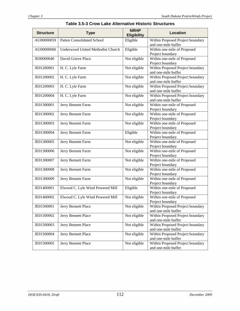
Chapter 3 South Dakota PrairieWinds Project
Table 3.5-3 Crow Lake Alternative Historic Structures
Structure Type NRHP Eligibility Location
AU00000059 Patten Consolidated School Eligible Within Proposed Project boundary and one-mile buffer
AU00000060 Underwood United Methodist Church Eligible Within one-mile of Proposed Project boundary
JE00000040 David Grieve Place Not eligible Within one-mile of Proposed Project boundary
JE01200001 H. C. Lyle Farm Not eligible Within Proposed Project boundary and one-mile buffer
JE01200002 H. C. Lyle Farm Not eligible Within Proposed Project boundary and one-mile buffer
JE01200003 H. C. Lyle Farm Not eligible Within Proposed Project boundary and one-mile buffer
JE01200004 H. C. Lyle Farm Not eligible Within Proposed Project boundary and one-mile buffer
JE01300001 Jerry Bennett Farm Not eligible Within one-mile of Proposed Project boundary
JE01300002 Jerry Bennett Farm Not eligible Within one-mile of Proposed Project boundary
JE01300003 Jerry Bennett Farm Not eligible Within one-mile of Proposed Project boundary
JE01300004 Jerry Bennett Farm Eligible Within one-mile of Proposed Project boundary
JE01300005 Jerry Bennett Farm Not eligible Within one-mile of Proposed Project boundary
JE01300006 Jerry Bennett Farm Not eligible Within one-mile of Proposed Project boundary
JE01300007 Jerry Bennett Farm Not eligible Within one-mile of Proposed Project boundary
JE01300008 Jerry Bennett Farm Not eligible Within one-mile of Proposed Project boundary
JE01300009 Jerry Bennett Farm Not eligible Within one-mile of Proposed Project boundary
JE01400001 Elwood C. Lyle Wind Powered Mill Eligible Within one-mile of Proposed Project boundary
JE01400002 Elwood C. Lyle Wind Powered Mill Not eligible Within one-mile of Proposed Project boundary
JE01500001 Jerry Bennett Place Not eligible Within Proposed Project boundary and one-mile buffer
JE01500002 Jerry Bennett Place Not eligible Within Proposed Project boundary and one-mile buffer
JE01500003 Jerry Bennett Place Not eligible Within Proposed Project boundary and one-mile buffer
JE01500004 Jerry Bennett Place Not eligible Within Proposed Project boundary and one-mile buffer
JE01500005 Jerry Bennett Place Not eligible Within Proposed Project boundary and one-mile buffer
DOE/EIS-0418, Draft 112 December 2009
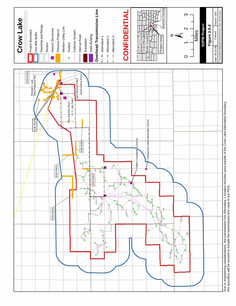
!!
!
!
!
!
!
!
!
!
!
!
!
!
!
!
!
!
!
!!
!
!!
!!
!!
!!
!!
!!
!!
!!
!!
!!
!!
!!
!!
!!
!!
!!
!!
!
!
!
!
!
!
!
!
!
!
!
!
!
!
!
!!
!
!
!!
!!
!!
!!
!
!
!
!
!
!
!
!
!
!
!
!
!
!
!
!
!
!
!
!
!
!
!
!
!
!
!
!
!
!
!
!
!
!
!
!
!
!
!
!
!
!
!
!
!
!
!
!
!
!
!
!
!
!
!
!
!
!
!
!
!
!
!
!
!
!
!
!
!
!
!
!
!
!
!
!
!
!
!
!
!
!
!
!
!
!
!
!
!
!
!
!
!
!
!
!
!
!
!
!
!
!
!
!
!
!
!
!
!
!
!
!
!
!
!
!
!
!
!
!
!
!
!
!
!
!
!
!
!
!
!
!
!
!
!
!
!
!
!
!
!
!
!
!
!
!
!
!
!
!
!
!
!
!
!
!
!
!
!
!
!
!
!
!
!
!
!
!
!
!
!
!
!
!
!
!
!
!
!
!
!
!
!
!
!
!
!
!
!
!
!
!
!
!
!
!
!
!
!
!
!
!
!
!
!
!
!
!
!
!
!
!
!
!
!
!
!
!
!
!
!
!
!
!
!
!
!
!
!
!
!
!
!
!
!
!
!
!
!
!
!
!
!
!!
!
!
!
!
!
!
!
!
!
!
!
!
!
!
!
!
!
!
!
!
!
!
!
!
!
!
!
!
!
!
!
!
!
!
!
!
!
!
!
"S"S"S"S"S
"S"S "S"S"S"S "S"S "S
"S"S"S"S "S
"S
"S
"S"S
"S"S"S"S
"S"S"S"S "S
"S!
!!!
!!
!!
!!
!!
!!
!!
!!
!
!!!
!!
!!
!!
!!
!
!!!!
!
!!
!!
!!
!!
!!!
!
!!
!!
!!
!!!!
!!
!!!
!(
!(
!(
!(
!(
!(
!(
!(
!(
!(
!(
!(
!(
!(
!(
!(
!(
!(
!(
!(
!(
!(
!(
!(
!(
!(
!(
!(
!(
!(
!(
!(
!(
!(
!(
!(
!(
!(
!(
!(
!(
!(
!(
!(
!(
!(
!(
!(
!(
!(
!(
!(
!(
!(
!(
!(
!(
!(
!(
!(
!(
!(
!(
!(
!(
!(
!(
!(
!(
!(
!(
!(!(
!(
!(
!(
!(
!(
!(
!(
!(
!(
!(
!(
!(
!(
!(
!(
!(
!(
!(
!(
!(
!(
!(
!(
!(
!(
!(
!(
!(
!(
!(
!(
!(
!(
!(
!(
!(
!(
!(
AJE
-002
2AJ
E-0
022
ESD
-030
1
AJE
-002
2AJ
E-0
022
ESD
-026
3
ESD
-028
8
ESD
-026
3
ESD
-026
3
AJE
-002
2
ESD
-028
8
H. C
. Lyl
e Fa
rm
Patte
n C
onso
lidat
ed S
choo
l
Und
erw
ood
Uni
ted
Met
hodi
st C
hurc
h
Elw
ood
C. L
yle
Win
d P
ower
ed M
ill
Dav
id G
rieve
Pla
ce
Jerr
y B
enne
tt Fa
rm
Jerr
y B
enne
tt Pl
ace
±
Crow
Lake
Proj
ect B
ound
ary
One
Mile
Buf
fer
Tow
nshi
p an
d R
ange
Sect
ion
"SH
isto
ric S
truct
ures
Prev
ious
Pro
ject
s!
!W
este
rn U
tility
Lin
e
!(Tu
rbin
e
Col
lect
or S
yste
m
Inte
rnal
Roa
d
Subs
tatio
n
O&M
Bui
ldin
g
Overh
ead T
ransm
ission
Line
!!
Alte
rnat
ive
1!
!Al
tern
ativ
e 2
!!
Alte
rnat
ive
3
01
23
Mile
s
Papa
go R
dD
ate:
06.
03.0
9Au
thor
: JA
GG
:\Dat
a\Ba
sin\
Map
s\EI
S\W
inne
r\Cro
w_L
ake_
Infra
stru
ctur
e
SDPW
Proje
ct
Cul
tura
l
Jera
uld
Cou
nty
Pro
ject
Are
aA
uror
a C
ount
y
Bru
le C
ount
y
CONF
IDEN
TIAL
Figur
e 3.5-
2
Due
to e
ngin
eerin
g co
nsid
erat
ions
, the
tran
smis
sion
line
Alte
rnat
ive
1 lo
catio
n in
clud
es a
rea
outs
ide
of th
e C
row
Lak
e A
ltern
ativ
e bo
unda
ry;
this
bou
ndar
y w
ill b
e re
vise
d to
incl
ude
the
trans
mis
sion
line
rout
e in
the
FEIS
.
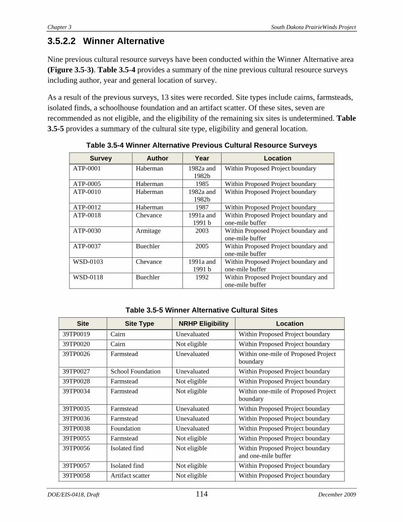
Chapter 3 South Dakota PrairieWinds Project
3.5.2.2 Winner Alternative
Nine previous cultural resource surveys have been conducted within the Winner Alternative area (Figure 3.5-3). Table 3.5-4 provides a summary of the nine previous cultural resource surveys including author, year and general location of survey.
As a result of the previous surveys, 13 sites were recorded. Site types include cairns, farmsteads, isolated finds, a schoolhouse foundation and an artifact scatter. Of these sites, seven are recommended as not eligible, and the eligibility of the remaining six sites is undetermined. Table 3.5-5 provides a summary of the cultural site type, eligibility and general location.
Table 3.5-4 Winner Alternative Previous Cultural Resource Surveys
Survey Author Year Location ATP-0001 Haberman 1982a and
1982b Within Proposed Project boundary
ATP-0005 Haberman 1985 Within Proposed Project boundary ATP-0010 Haberman 1982a and
1982b Within Proposed Project boundary
ATP-0012 Haberman 1987 Within Proposed Project boundary ATP-0018 Chevance 1991a and
1991 b Within Proposed Project boundary and one-mile buffer
ATP-0030 Armitage 2003 Within Proposed Project boundary and one-mile buffer
ATP-0037 Buechler 2005 Within Proposed Project boundary and one-mile buffer
WSD-0103 Chevance 1991a and 1991 b
Within Proposed Project boundary and one-mile buffer
WSD-0118 Buechler 1992 Within Proposed Project boundary and one-mile buffer
Table 3.5-5 Winner Alternative Cultural Sites
Site Site Type NRHP Eligibility Location 39TP0019 Cairn Unevaluated Within Proposed Project boundary39TP0020 Cairn Not eligible Within Proposed Project boundary39TP0026 Farmstead Unevaluated Within one-mile of Proposed Project
boundary 39TP0027 School Foundation Unevaluated Within Proposed Project boundary39TP0028 Farmstead Not eligible Within Proposed Project boundary39TP0034 Farmstead Not eligible Within one-mile of Proposed Project
boundary 39TP0035 Farmstead Unevaluated Within Proposed Project boundary39TP0036 Farmstead Unevaluated Within Proposed Project boundary39TP0038 Foundation Unevaluated Within Proposed Project boundary39TP0055 Farmstead Not eligible Within Proposed Project boundary39TP0056 Isolated find Not eligible Within Proposed Project boundary
and one-mile buffer 39TP0057 Isolated find Not eligible Within Proposed Project boundary39TP0058 Artifact scatter Not eligible Within Proposed Project boundary
DOE/EIS-0418, Draft 114 December 2009
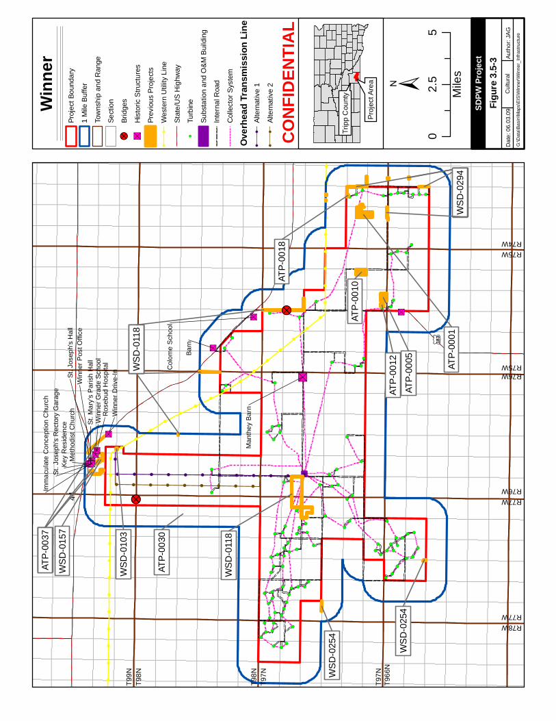
!!
!!
!!
!!
!!
!!
!!
!!
!!
!!
!!
!
!
!
!
!
!
!
!
!
!
!
!
!
!
!
!
!!
!!
!!
!!
!!
!!
!!
!!
!!
!
!
!
!
!
!
!
!
!
!
!
!
!
!
!
!
!
!
!
!
!
!
!
!
!!
!!
!!
!!
!!
!!
!!
!!
!!
!!
!!
!!
!!
!!
!!
!!
!
!!
!
!
!!!!!!!!!!!
!
!
!!!!!!!!!
!(
!(
!(
!(
!(
!(!(
!(!(
!(!(
!(
!( !(
!(
!(
!(
!(
!(
!(
!(
!(
!(
!(
!(
!(
!(
!(!(
!(!(
!(
!(
!(
!(!(
!(
!(
!(
!(
!(
!(
!(
!(
!(
!(
!( !(
!(
!(
!(
!( !(
!(
!(
!(
!(
!(
!(
!(
!(
!(
!(
!(
!(
!(
!(
!(
!(
!(
!(
!(
!(
!(
!(
!(
!(
!(
!(
!(
!(
!(
!(
!(!(
!(
!(
!(
!(
!(
!(
!(
!(
!(
!(!(
!(
!(
!(
!(
!(
!(
!(
!(
!(
!(
!(
!(!(
!(
!(
" S
" S
" S " S
" S
" S
" S
" S " S" S" S " S" S" S
" S
! ?
! ?
44
£ ¤183
WS
D-0
118
Barn
WS
D-0
118
WS
D-0
118
WS
D-0
118
ATP-
0037
ATP-
0037
ATP-
0037
WS
D-0
294
WS
D-0
254
WS
D-0
103
WS
D-0
294
WS
D-0
294
WS
D-0
157
ATP-
0030
ATP-
0001
ATP-
0010
ATP-
0005
ATP-
0012
WS
D-0
294
ATP-
0018
WS
D-0
254
Col
ome
Sch
ool
Man
they
Bar
n
Key
Res
iden
ce
Win
ner D
rive-
InR
oseb
ud H
ospi
tal
Met
hodi
st C
hurc
hSt
. Jos
eph'
s H
all
Win
ner P
ost O
ffice
Win
ner G
rade
Sch
ool
St. M
ary'
s P
aris
h H
all
St. J
osep
h's
Rec
tory
Gar
age
Imm
acul
ate
Con
cept
ion
Chu
rch
±
Winn
erPr
ojec
t Bou
ndar
y
1 M
ile B
uffe
r
Tow
nshi
p an
d R
ange
Sect
ion
!?Br
idge
s
"SH
isto
ric S
truct
ures
Prev
ious
Pro
ject
s
!!
Wes
tern
Util
ity L
ine
Stat
e/U
S H
ighw
ay!(
Turb
ine
Subs
tatio
n an
d O
&M
Bui
ldin
g
Inte
rnal
Roa
d
Col
lect
or S
yste
m
Overh
ead T
ransm
ission
Line
!!
Alte
rnat
ive
1
!!
Alte
rnat
ive
2
02.
55
Mile
s
Papa
go R
dD
ate:
06.
03.0
9Au
thor
: JA
GG
:\Dat
a\Ba
sin\
Map
s\EI
S\W
inne
r\Win
ner_
Infra
stru
ctur
e
SDPW
Proje
ct
Cul
tura
l
Trip
p C
ount
y
Pro
ject
Are
a
CONF
IDEN
TIAL
Figur
e 3.5-
3
R77WR76W
R76WR75W
T966
NT9
7N
T98N
T99N
R78WR77W
R75WR74W
T97N
T98N
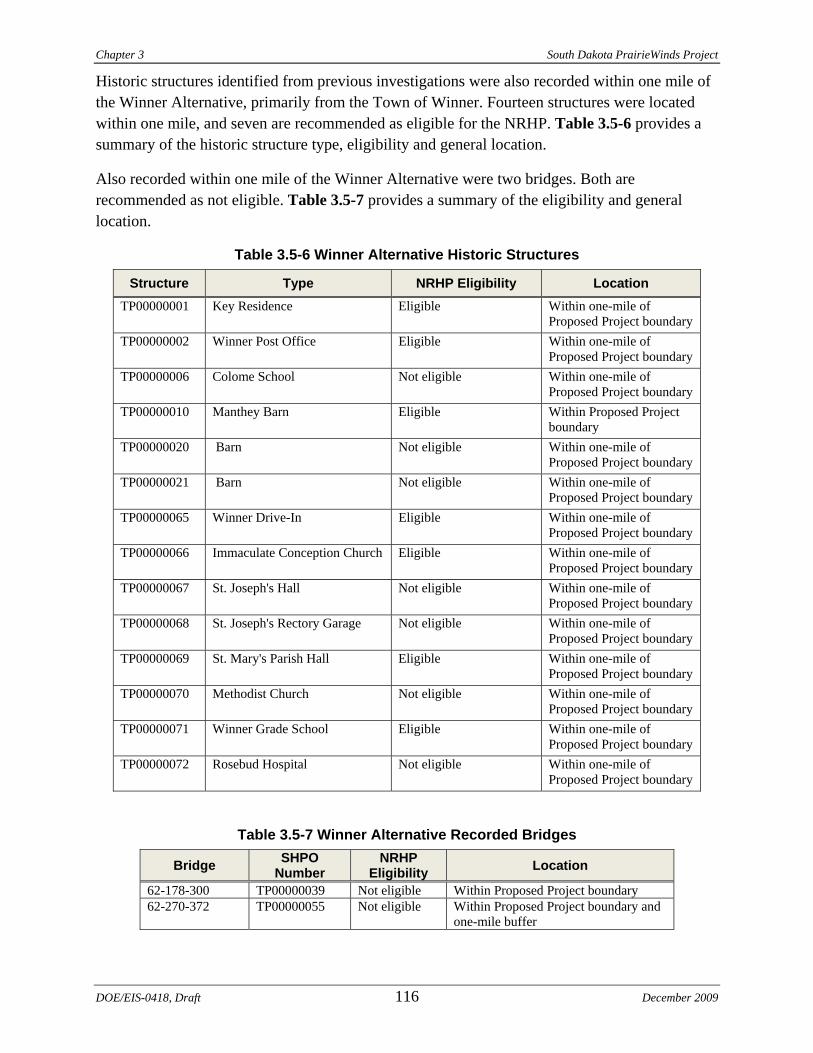
Chapter 3 South Dakota PrairieWinds Project
DOE/EIS-0418, Draft 116 December 2009
Historic structures identified from previous investigations were also recorded within one mile of the Winner Alternative, primarily from the Town of Winner. Fourteen structures were located within one mile, and seven are recommended as eligible for the NRHP. Table 3.5-6 provides a summary of the historic structure type, eligibility and general location.
Also recorded within one mile of the Winner Alternative were two bridges. Both are recommended as not eligible. Table 3.5-7 provides a summary of the eligibility and general location.
Table 3.5-6 Winner Alternative Historic Structures
Structure Type NRHP Eligibility Location TP00000001 Key Residence Eligible Within one-mile of
Proposed Project boundary TP00000002 Winner Post Office Eligible Within one-mile of
Proposed Project boundary TP00000006 Colome School Not eligible Within one-mile of
Proposed Project boundary TP00000010 Manthey Barn Eligible Within Proposed Project
boundary TP00000020 Barn Not eligible Within one-mile of
Proposed Project boundary TP00000021 Barn Not eligible Within one-mile of
Proposed Project boundary TP00000065 Winner Drive-In Eligible Within one-mile of
Proposed Project boundary TP00000066 Immaculate Conception Church Eligible Within one-mile of
Proposed Project boundary TP00000067 St. Joseph's Hall Not eligible Within one-mile of
Proposed Project boundary TP00000068 St. Joseph's Rectory Garage Not eligible Within one-mile of
Proposed Project boundary TP00000069 St. Mary's Parish Hall Eligible Within one-mile of
Proposed Project boundary TP00000070 Methodist Church Not eligible Within one-mile of
Proposed Project boundary TP00000071 Winner Grade School Eligible Within one-mile of
Proposed Project boundary TP00000072 Rosebud Hospital Not eligible Within one-mile of
Proposed Project boundary
Table 3.5-7 Winner Alternative Recorded Bridges
Bridge SHPO Number
NRHP Eligibility Location
62-178-300 TP00000039 Not eligible Within Proposed Project boundary 62-270-372 TP00000055 Not eligible Within Proposed Project boundary and
one-mile buffer
South Dakota PrairieWinds Project Chapter 3
3.6 LAND USE The ROI for land use includes areas of immediate disturbance associated with the Proposed Project Components and proposed Federal actions. Land uses such as agriculture, designated prime farmland and farmland of statewide importance, rangeland, natural resource conservation areas, residential uses and recreational opportunities were identified within the alternatives.
3.6.1 GENERAL LAND USE
The majority of the region, including both Proposed Project alternatives, is currently used for rangeland and agriculture. Western’s Wessington Springs and Winner substations are industrial uses. Reviews of aerial photographs, existing public inventories (e.g., USFWS, NWI, NRCS databases) and field studies were used to identify the land uses within the sites. Tierra EC contacted Aurora, Brule, Jerauld and Tripp county planners and managers to inquire whether existing land use plans for the counties were available (Hirsh 2009b) (Reindle 2009b) (Vissia 2009b) (Westindorf 2009b). Land use plans for Aurora and Brule counties are currently being revised. Jerauld County’s Comprehensive Plan was approved in 1998. No land use plan is available for Tripp County.
3.6.1.1 Crow Lake Alternative
Table 3.6-1 and Figure 3.4-1 (in Section 3.4) identify current land uses at the Crow Lake Alternative.
Table 3.6-1 Crow Lake Alternative Current Land Use Land Use Percentage of Area
64% Rangeland (mixed-grass prairie) 33% Agricultural (cropland) 1.4% Wetland <1% Farmstead <1% Shelterbelt <1% Deciduous forest <1% Industrial (mine/quarry)
Source: Tierra EC 2009
December 2009 117 DOE/EIS-0418, Draft
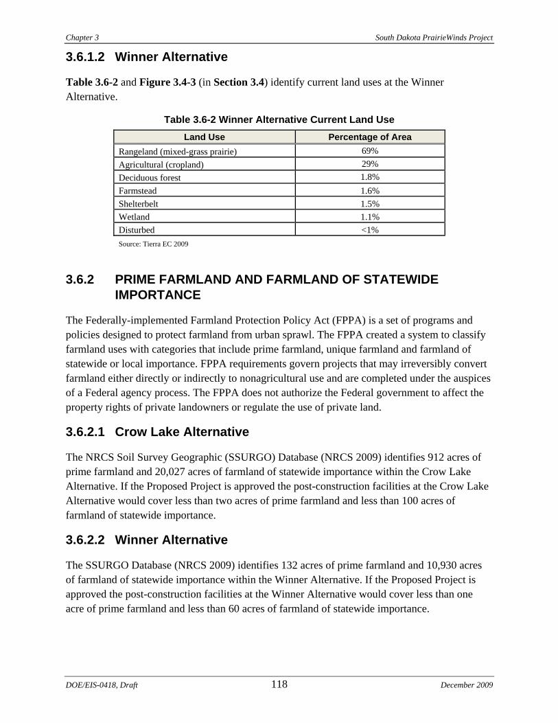
Chapter 3 South Dakota PrairieWinds Project
3.6.1.2 Winner Alternative
Table 3.6-2 and Figure 3.4-3 (in Section 3.4) identify current land uses at the Winner Alternative.
Table 3.6-2 Winner Alternative Current Land Use Land Use Percentage of Area
69% Rangeland (mixed-grass prairie) 29% Agricultural (cropland) 1.8% Deciduous forest
Farmstead 1.6% Shelterbelt 1.5% Wetland 1.1% Disturbed <1% Source: Tierra EC 2009
3.6.2 PRIME FARMLAND AND FARMLAND OF STATEWIDE IMPORTANCE
The Federally-implemented Farmland Protection Policy Act (FPPA) is a set of programs and policies designed to protect farmland from urban sprawl. The FPPA created a system to classify farmland uses with categories that include prime farmland, unique farmland and farmland of statewide or local importance. FPPA requirements govern projects that may irreversibly convert farmland either directly or indirectly to nonagricultural use and are completed under the auspices of a Federal agency process. The FPPA does not authorize the Federal government to affect the property rights of private landowners or regulate the use of private land.
3.6.2.1 Crow Lake Alternative
The NRCS Soil Survey Geographic (SSURGO) Database (NRCS 2009) identifies 912 acres of prime farmland and 20,027 acres of farmland of statewide importance within the Crow Lake Alternative. If the Proposed Project is approved the post-construction facilities at the Crow Lake Alternative would cover less than two acres of prime farmland and less than 100 acres of farmland of statewide importance.
3.6.2.2 Winner Alternative
The SSURGO Database (NRCS 2009) identifies 132 acres of prime farmland and 10,930 acres of farmland of statewide importance within the Winner Alternative. If the Proposed Project is approved the post-construction facilities at the Winner Alternative would cover less than one acre of prime farmland and less than 60 acres of farmland of statewide importance.
DOE/EIS-0418, Draft 118 December 2009
South Dakota PrairieWinds Project Chapter 3
3.6.3 CONSERVATION EASEMENTS
Areas within the Proposed Project alternatives include lands that are encumbered by perpetual easements administered by the USFWS for conservation. The USFWS has been purchasing conservation easements in the prairie pothole region since 1958 as an approach to waterfowl habitat management. These conservation easements are minimally restrictive instruments that grant the USFWS the ability to protect the grassland and wetland habitat on the properties where these easements are recorded. Easements are administered as part of the National Wildlife Refuge System, acquired as an alternative to fee-title acquisition and intended to perpetually protect grasslands and wetlands to benefit migratory birds and other wildlife.
3.6.3.1 Crow Lake Alternative
USFWS conservation easements within the Crow Lake Alternative boundary include 2,836 acres of Wetland Easement and 1,629 acres of Grassland Easement. The areas preserved account for 12 percent of the site in total, and are scattered throughout, as depicted in Figure 3.4-2. The conservation easements are further discussed in Section 3.4.
3.6.3.2 Winner Alternative
USFWS conservation easements within the Winner Alternative boundary include one 220-acre parcel identified as Grassland Easement west of the City of Colome, as depicted in Figure 3.4-4. This parcel amounts to 0.26 percent of the area included in the site. The conservation easements are further discussed in Section 3.4.
3.6.4 RESIDENTIAL USE
3.6.4.1 Crow Lake Alternative
The Crow Lake Alternative contains a total of 27 residences; each within a farmstead property, and may be occupied permanently, seasonally or for recreational/hunting purposes. The total farmstead acreage constitutes less than one percent of the acreage of the site. No residences are within 1,000 feet of the proposed turbine locations. The closest residence is approximately 1,270 feet away from a proposed turbine. The closest residence to the proposed transmission line right-of-way would be located approximately 1,900 feet away. The nearest residence to the alternative transmission corridor right-of-way is at least 2,800 feet away. The nearest residence to the proposed collector substation would be located approximately 6,700 feet away. The nearest residence to Western’s existing Wessington Springs Substation is 1,500 feet away.
3.6.4.2 Winner Alternative
The Winner Alternative contains a total of 127 residences; each included within a farmstead property, and may be occupied permanently, seasonally or for recreational/hunting purposes. The total farmstead acreage constitutes less than 1.6 percent of the acreage of the site. One residence is located within 1,000 feet of a proposed turbine location, at a distance of approximately 800
December 2009 119 DOE/EIS-0418, Draft
Chapter 3 South Dakota PrairieWinds Project
feet. All other residences are located more than 1,000 feet from proposed turbine locations. The closest residence to a proposed transmission line is 100 feet away from the proposed transmission corridor centerline. The closest residence to an alternative transmission line is 900 feet away from the alternative transmission corridor centerline. The nearest residence to the proposed collector substation would be located approximately 1,400 feet away. The nearest residence to Western’s existing Winner Substation is 300 feet away.
3.6.5 RECREATION
Recreational opportunities in the vicinity of each of the Proposed Project alternatives are the same. According to the South Dakota Division of Parks and Recreation (SDDPR) many outdoor recreation activities are available to the public within the State (i.e., fishing, camping, off-highway vehicle use, Lewis and Clark exploration activities); these activities include a wide range of options depending on the time of year and specific interest. Hunting in South Dakota is a popular recreational activity that can be experienced year-round, on nearly five million acres of public land (SDDPR 2009), and is popular within the alternatives.
Pheasant and other upland game hunting, waterfowl hunting, small game, and deer hunting seasons all open in the fall. Late season deer and predator hunting occur during the winter months. In the spring, hunters can participate in turkey and light goose seasons. In the off-season, prairie dog hunting and other varmint hunting are permitted on private land (with permission).
3.7 TRANSPORTATION The ROI for roads and highways includes existing and proposed roads near the Proposed Project alternatives that would be used for delivery of construction equipment, construction worker access and maintenance access. The ROI for aviation includes airports within 20 miles.
3.7.1 ROADS AND HIGHWAYS
This section includes an evaluation of current road conditions and aviation activities near the Proposed Project alternatives. Information used to develop this section includes regional transportation planning documents from SDDOT. Information pertaining to aviation safety standards was obtained from FAA.
Table 3.7-1 provides a brief inventory of the status and trends of the regional road infrastructure for each of the Proposed Project alternatives.
DOE/EIS-0418, Draft 120 December 2009
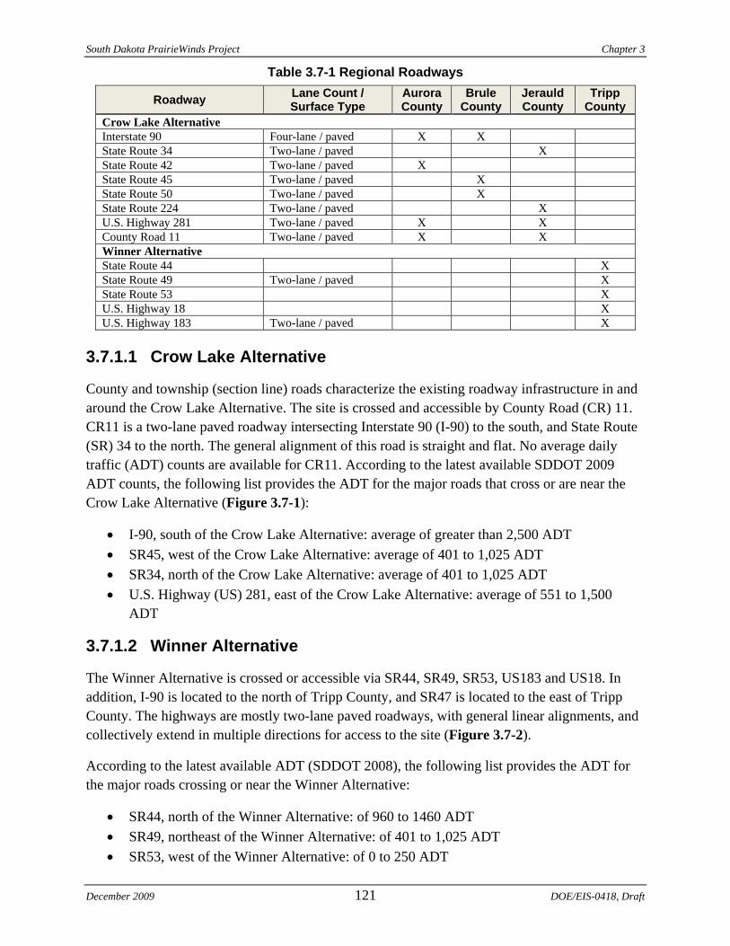
South Dakota PrairieWinds Project Chapter 3
Table 3.7-1 Regional Roadways
Roadway Lane Count / Surface Type
Aurora County
Brule County
Jerauld County
Tripp County
Crow Lake Alternative Interstate 90 Four-lane / paved X X State Route 34 Two-lane / paved X State Route 42 Two-lane / paved X State Route 45 Two-lane / paved X State Route 50 Two-lane / paved X State Route 224 Two-lane / paved X U.S. Highway 281 Two-lane / paved X X County Road 11 Two-lane / paved X X Winner Alternative State Route 44 X State Route 49 Two-lane / paved X State Route 53 X U.S. Highway 18 X U.S. Highway 183 Two-lane / paved X
3.7.1.1 Crow Lake Alternative
County and township (section line) roads characterize the existing roadway infrastructure in and around the Crow Lake Alternative. The site is crossed and accessible by County Road (CR) 11. CR11 is a two-lane paved roadway intersecting Interstate 90 (I-90) to the south, and State Route (SR) 34 to the north. The general alignment of this road is straight and flat. No average daily traffic (ADT) counts are available for CR11. According to the latest available SDDOT 2009 ADT counts, the following list provides the ADT for the major roads that cross or are near the Crow Lake Alternative (Figure 3.7-1):
• I-90, south of the Crow Lake Alternative: average of greater than 2,500 ADT • SR45, west of the Crow Lake Alternative: average of 401 to 1,025 ADT • SR34, north of the Crow Lake Alternative: average of 401 to 1,025 ADT • U.S. Highway (US) 281, east of the Crow Lake Alternative: average of 551 to 1,500
ADT
3.7.1.2 Winner Alternative
The Winner Alternative is crossed or accessible via SR44, SR49, SR53, US183 and US18. In addition, I-90 is located to the north of Tripp County, and SR47 is located to the east of Tripp County. The highways are mostly two-lane paved roadways, with general linear alignments, and collectively extend in multiple directions for access to the site (Figure 3.7-2).
According to the latest available ADT (SDDOT 2008), the following list provides the ADT for the major roads crossing or near the Winner Alternative:
• SR44, north of the Winner Alternative: of 960 to 1460 ADT • SR49, northeast of the Winner Alternative: of 401 to 1,025 ADT • SR53, west of the Winner Alternative: of 0 to 250 ADT
December 2009 121 DOE/EIS-0418, Draft
Chapter 3 South Dakota PrairieWinds Project
DOE/EIS-0418, Draft 122 December 2009
• US183, crossing the Winner Alternative in an north / south direction: of 125.5 to 400 ADT
• US18, northeast of the Winner Alternative: of 1,501 to 2,500 ADT
3.7.2 AVIATION
3.7.2.1 Crow Lake Alternative
Three airports are within 20 miles of the Crow Lake Alternative. The Wessington Springs Airport and Kimball Municipal Airport are municipal airports serving the local communities, with less than 300 takeoffs/landings per year each (SDDOT Aeronautics 2007). Drake Farm is a farm airfield used for local agricultural purposes (annual reporting of takeoffs/landings was unavailable for this airfield).
• Wessington Springs Airport: Public airport near the Town of Wessington Springs, approximately eight miles from the site
• Kimball Municipal Airport: Public airport near the City of Kimball, approximately seven miles from the site
• Drake Farm: Private airport used primarily for agricultural purposes near the City of White Lake, approximately nine miles from the site
3.7.2.2 Winner Alternative
Two airports and one helipad are within 20 miles of the Winner Alternative. The Winner Regional Airport is used for takeoffs/landings over 20,000 times per year, with nearly half of that being local traffic staying within 20 miles; and the Gregory Municipal Airport is less heavily used at 6,500 takeoffs/landings per year, nearly a third of which is local traffic (SDDOT Aeronautics 2009).
• Winner Regional Airport: Public airport near the City of Winner, approximately two miles from the site
• Gregory Municipal Airport, Flynn Field: Public airport near the City of Gregory, approximately nine miles from the site
• Burke Hospital Helipad: Private Helipad used for hospital emergency rescue services, near the City of Burke, approximately 16 miles from the site
Sout
h D
akot
a Pr
airi
eWin
ds P
roje
ct
Cha
pter
3
Sour
ce: S
DD
OT
2008
Figu
re 3
.7-1
Cro
w L
ake
Alte
rnat
ive
Traf
fic F
low
Map
Dec
embe
r 200
9 12
3 D
OE/
EIS-
0418
, Dra
ft
Chapter 3 South Dakota PrairieWinds Project
Source: SDDOT 2008
Figure 3.7-2 Winner Alternative Traffic Flow Map
DOE/EIS-0418, Draft 124 December 2009
South Dakota PrairieWinds Project Chapter 3
3.8 VISUAL RESOURCES This section evaluates the existing visual setting in the vicinity of the alternatives. The ROI includes areas within and adjacent to the Proposed Project area from which a person may observe changes to the visual landscape resulting from development of the Proposed Project Components. These areas include residences within the alternative site boundaries, nearby population centers and nearby roadways.
3.8.1 EXISTING VISUAL SETTING
The following aesthetic values were considered when evaluating the visual setting of the existing landscape:
• Form: topographic variation, mountains and valleys • Line and pattern: roads and transmission lines • Color and contrast: brightness and diversity • Texture: vegetation, buildings and disturbed areas
3.8.1.1 Crow Lake Alternative
Topography of the Crow Lake Alternative is characterized by gently rolling hills with low to moderate relief. Elevation ranges from approximately 1,985 to 2,510 feet AMSL. Mixed-grass prairie (including rangeland, pastureland and CRP/prairie) dominates the vegetation. Additional vegetation includes cropland, wetlands (including stock ponds), farmsteads and patches of deciduous trees (mostly shelterbelts) (Tierra EC 2009). Overall, the Crow Lake Alternative is rural in character. The predominant land uses include livestock grazing, farming, sparse farmstead residential development, fencing and a rural road network consisting of paved roads, gravel roads and two-track roads developed primarily on portions of section lines. In addition, the existing Wessington Springs Wind Project, a 51-MW wind energy generating facility, is located adjacent to the northeast edge of the Crow Lake Alternative.
There are 27 farmstead residences located within the boundaries of the Crow Lake Alternative. The Town of Crow Lake is within one mile of the Proposed Project boundary and had a population of 46 at the time of the 2000 census. Kimball, Wessington Springs and White Lake are the only other population centers located within seven to nine miles of the Crow Lake Alternative.
Roadways described in Section 3.7.3 from which the area may be viewed include I-90, SR45 and SR50 (see Figure 3.7-1). A portion of SR50 has been designated as the Native American Scenic Byway. The Native American Scenic Byway extends approximately 357 miles between North Dakota and South Dakota and provides memorial markers, monuments, museums and sacred sites that commemorate the heritage of the Sioux Nation. Portions of I-90 and SR50 are included in the Lewis and Clark Trail Driving Route (LCTDR), which is associated with the Lewis and Clark National Historic Trail (NHT). The Lewis and Clark NHT is administered by NPS. The LCTDR is a network of roads that generally tracks the Lewis and Clark NHT along the Missouri
December 2009 125 DOE/EIS-0418, Draft
Chapter 3 South Dakota PrairieWinds Project
DOE/EIS-0418, Draft 126 December 2009
River and provides vistas as well as historic markers. The Lewis and Clark NHT extends more than 3,700 miles and includes the entire Missouri River from its headwaters in Montana to its confluence with the Mississippi River near St. Louis, Missouri. Under the National Trail System Act and the Organic Act, NPS is charged with preservation of natural scenes and landscapes for enjoyment by future generations.
3.8.1.2 Winner Alternative
The rolling plains of the Winner Alternative include elevation ranges from approximately 1,644 to 1,985 feet AMSL. Mixed-grass prairie (including rangeland, pastureland and CRP/prairie) dominate the vegetation. Additional vegetation includes cropland, wetlands (including herbaceous wetlands, forested wetlands, stock ponds and lakes), deciduous forests, farmsteads and shelterbelts (Tierra EC 2009). Overall, the Winner Alternative is rural in character. The predominant land uses include livestock grazing, farming, sparse farmstead residential development, fencing and a rural road network consisting of paved roads, gravel roads and two-track roads developed primarily on portions of section lines.
There are 127 farmstead residences within the boundaries of the Winner Alternative. The towns of Winner and Colome are within one mile of the project boundary and had a population of 3,137 and 333, respectively, at the time of the 2000 census. Clearfield, Dallas and Gregory are the population centers within three to nine miles of the Winner Alternative.
Roadways described in Section 3.7.3 from which the area may be viewed include I-90, SR44, SR47 and US18 (see Figure 3.7-2). In the vicinity of the Winner Alternative, portions of SR44 and US18 are included in the LCTDR.
3.8.2 KEY OBSERVATION POINTS
Key observation points (KOPs) were selected to depict the general visual setting of each of the alternatives and provide a baseline for developing visual simulations (presented in Section 4.8). Based on public input received during the EIS scoping process, local (i.e., residents within and near the alternative site boundaries) sensitivity to visual changes as a result of the Proposed Project is low. Therefore, KOPs were selected for each of the alternatives based on topography and the potential to view the Proposed Project from the LCTDR and associated interpretive center. The foreground (area within three to five miles) and background (area further than three to five miles) are described for each KOP. Figure 3.8-1 depicts the locations of the KOPs in relation to the alternatives and LCTDR.
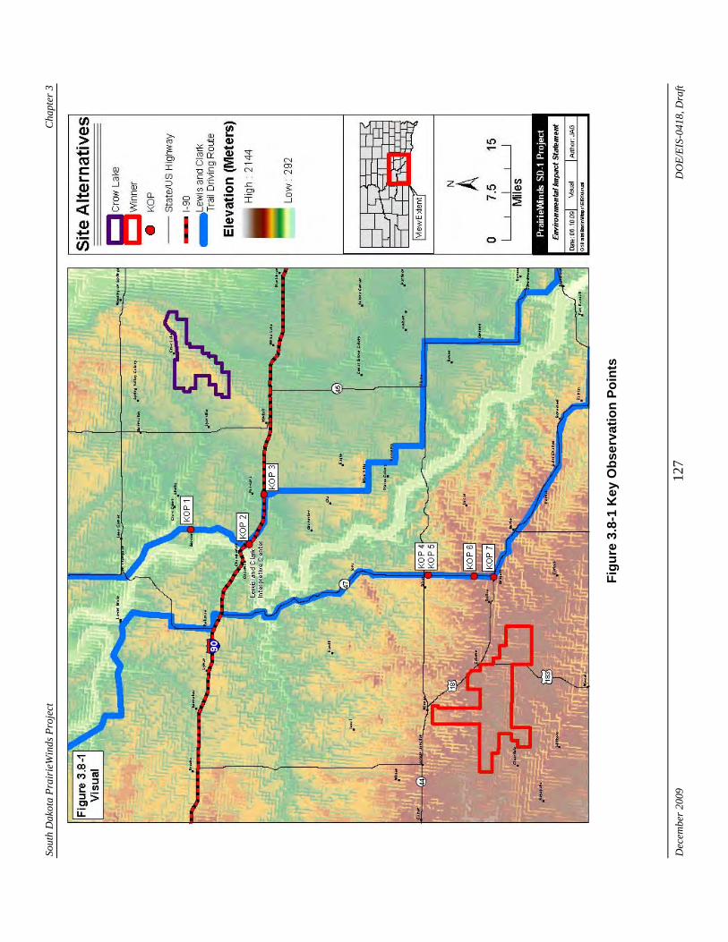
Sout
h D
akot
a Pr
airi
eWin
ds P
roje
ct
Cha
pter
3
Figu
re 3
.8-1
Key
Obs
erva
tion
Poin
ts
Dec
embe
r 200
9 12
7 D
OE/
EIS-
0418
, Dra
ft
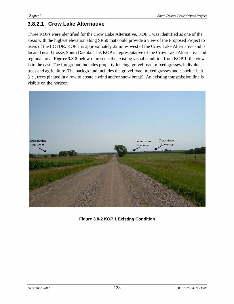
Chapter 3 South Dakota PrairieWinds Project
3.8.2.1 Crow Lake Alternative
Three KOPs were identified for the Crow Lake Alternative. KOP 1 was identified as one of the areas with the highest elevation along SR50 that could provide a view of the Proposed Project to users of the LCTDR. KOP 1 is approximately 22 miles west of the Crow Lake Alternative and is located near Grosse, South Dakota. This KOP is representative of the Crow Lake Alternative and regional area. Figure 3.8-2 below represents the existing visual condition from KOP 1; the view is to the east. The foreground includes property fencing, gravel road, mixed grasses, individual trees and agriculture. The background includes the gravel road, mixed grasses and a shelter belt (i.e., trees planted in a row to create a wind and/or snow break). An existing transmission line is visible on the horizon.
Figure 3.8-2 KOP 1 Existing Condition
December 2009 128 DOE/EIS-0418, Draft
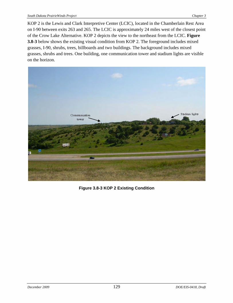
South Dakota PrairieWinds Project Chapter 3
KOP 2 is the Lewis and Clark Interpretive Center (LCIC), located in the Chamberlain Rest Area on I-90 between exits 263 and 265. The LCIC is approximately 24 miles west of the closest point of the Crow Lake Alternative. KOP 2 depicts the view to the northeast from the LCIC. Figure 3.8-3 below shows the existing visual condition from KOP 2. The foreground includes mixed grasses, I-90, shrubs, trees, billboards and two buildings. The background includes mixed grasses, shrubs and trees. One building, one communication tower and stadium lights are visible on the horizon.
Figure 3.8-3 KOP 2 Existing Condition
December 2009 129 DOE/EIS-0418, Draft
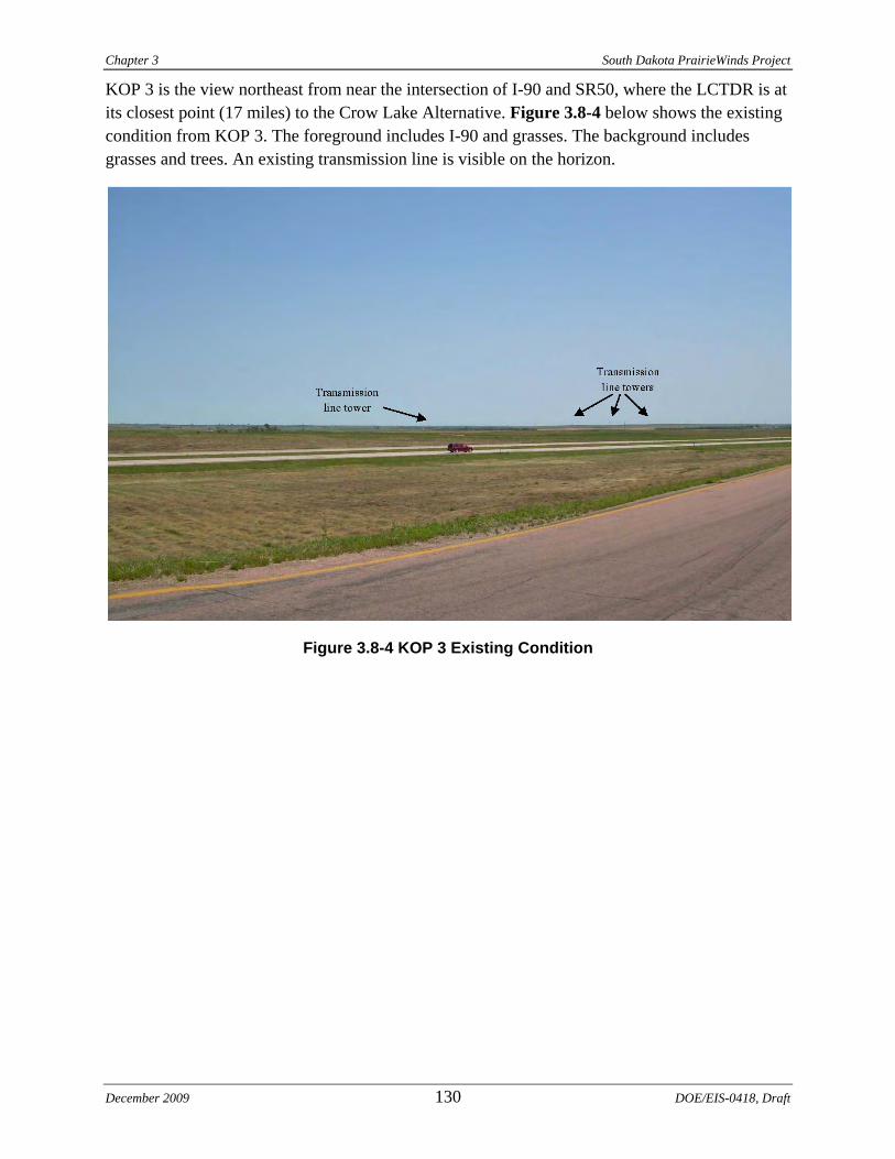
Chapter 3 South Dakota PrairieWinds Project
KOP 3 is the view northeast from near the intersection of I-90 and SR50, where the LCTDR is at its closest point (17 miles) to the Crow Lake Alternative. Figure 3.8-4 below shows the existing condition from KOP 3. The foreground includes I-90 and grasses. The background includes grasses and trees. An existing transmission line is visible on the horizon.
Figure 3.8-4 KOP 3 Existing Condition
December 2009 130 DOE/EIS-0418, Draft
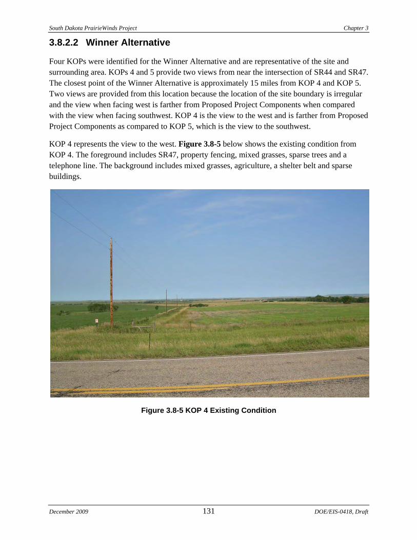
South Dakota PrairieWinds Project Chapter 3
3.8.2.2 Winner Alternative
Four KOPs were identified for the Winner Alternative and are representative of the site and surrounding area. KOPs 4 and 5 provide two views from near the intersection of SR44 and SR47. The closest point of the Winner Alternative is approximately 15 miles from KOP 4 and KOP 5. Two views are provided from this location because the location of the site boundary is irregular and the view when facing west is farther from Proposed Project Components when compared with the view when facing southwest. KOP 4 is the view to the west and is farther from Proposed Project Components as compared to KOP 5, which is the view to the southwest.
KOP 4 represents the view to the west. Figure 3.8-5 below shows the existing condition from KOP 4. The foreground includes SR47, property fencing, mixed grasses, sparse trees and a telephone line. The background includes mixed grasses, agriculture, a shelter belt and sparse buildings.
Figure 3.8-5 KOP 4 Existing Condition
December 2009 131 DOE/EIS-0418, Draft
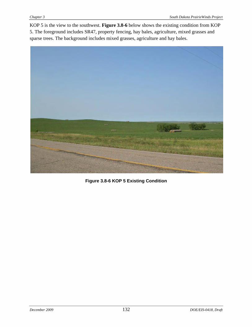
Chapter 3 South Dakota PrairieWinds Project
KOP 5 is the view to the southwest. Figure 3.8-6 below shows the existing condition from KOP 5. The foreground includes SR47, property fencing, hay bales, agriculture, mixed grasses and sparse trees. The background includes mixed grasses, agriculture and hay bales.
Figure 3.8-6 KOP 5 Existing Condition
December 2009 132 DOE/EIS-0418, Draft
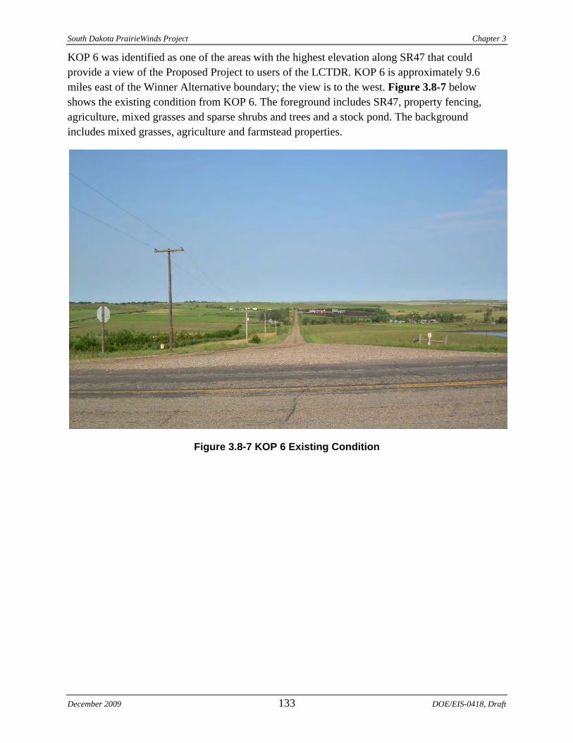
South Dakota PrairieWinds Project Chapter 3
KOP 6 was identified as one of the areas with the highest elevation along SR47 that could provide a view of the Proposed Project to users of the LCTDR. KOP 6 is approximately 9.6 miles east of the Winner Alternative boundary; the view is to the west. Figure 3.8-7 below shows the existing condition from KOP 6. The foreground includes SR47, property fencing, agriculture, mixed grasses and sparse shrubs and trees and a stock pond. The background includes mixed grasses, agriculture and farmstead properties.
Figure 3.8-7 KOP 6 Existing Condition
December 2009 133 DOE/EIS-0418, Draft
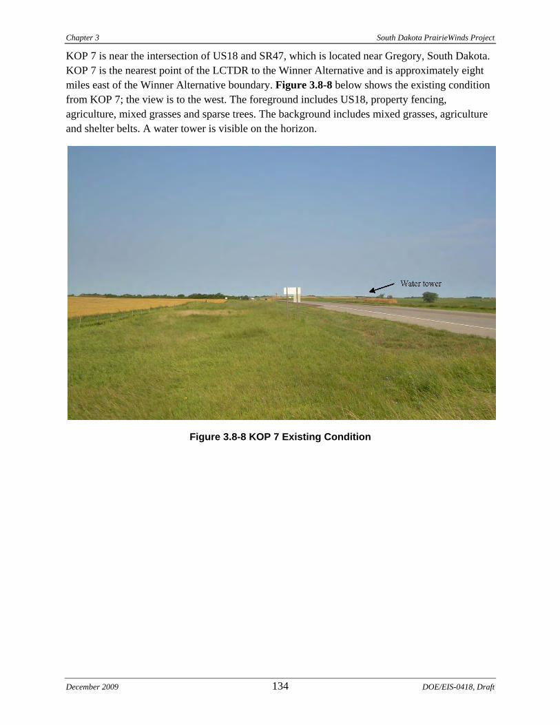
Chapter 3 South Dakota PrairieWinds Project
KOP 7 is near the intersection of US18 and SR47, which is located near Gregory, South Dakota. KOP 7 is the nearest point of the LCTDR to the Winner Alternative and is approximately eight miles east of the Winner Alternative boundary. Figure 3.8-8 below shows the existing condition from KOP 7; the view is to the west. The foreground includes US18, property fencing, agriculture, mixed grasses and sparse trees. The background includes mixed grasses, agriculture and shelter belts. A water tower is visible on the horizon.
Figure 3.8-8 KOP 7 Existing Condition
December 2009 134 DOE/EIS-0418, Draft
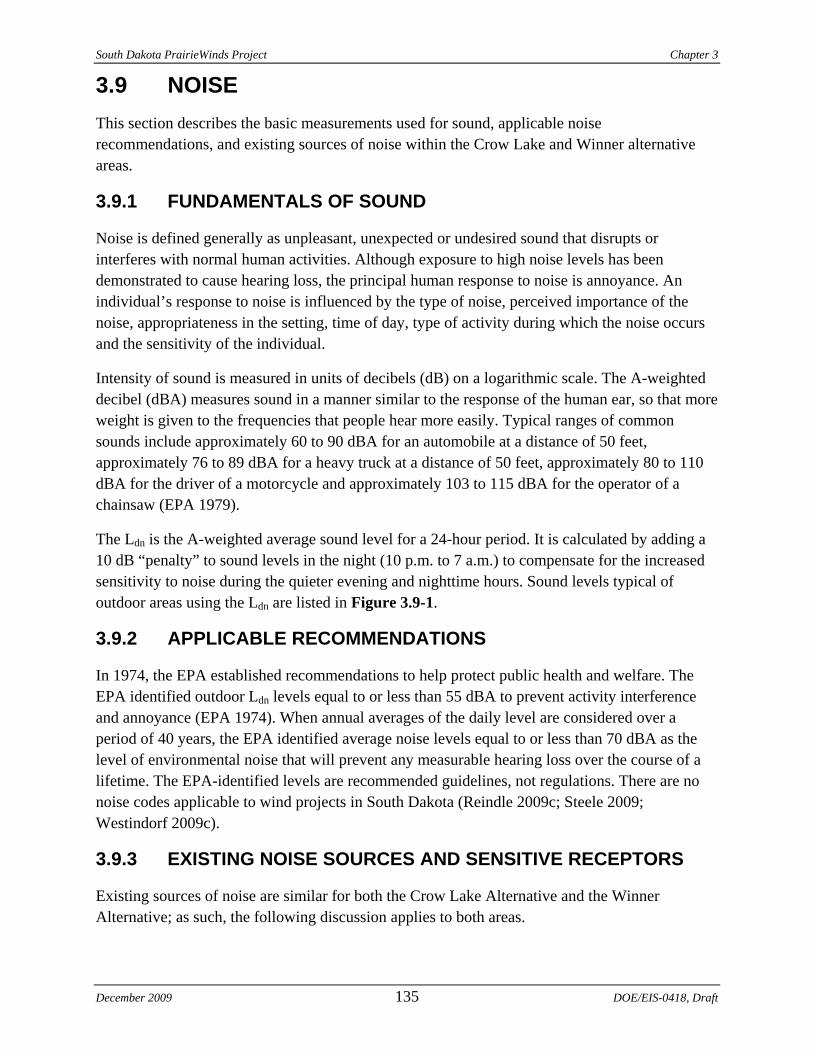
South Dakota PrairieWinds Project Chapter 3
3.9 NOISE This section describes the basic measurements used for sound, applicable noise recommendations, and existing sources of noise within the Crow Lake and Winner alternative areas.
3.9.1 FUNDAMENTALS OF SOUND
Noise is defined generally as unpleasant, unexpected or undesired sound that disrupts or interferes with normal human activities. Although exposure to high noise levels has been demonstrated to cause hearing loss, the principal human response to noise is annoyance. An individual’s response to noise is influenced by the type of noise, perceived importance of the noise, appropriateness in the setting, time of day, type of activity during which the noise occurs and the sensitivity of the individual.
Intensity of sound is measured in units of decibels (dB) on a logarithmic scale. The A-weighted decibel (dBA) measures sound in a manner similar to the response of the human ear, so that more weight is given to the frequencies that people hear more easily. Typical ranges of common sounds include approximately 60 to 90 dBA for an automobile at a distance of 50 feet, approximately 76 to 89 dBA for a heavy truck at a distance of 50 feet, approximately 80 to 110 dBA for the driver of a motorcycle and approximately 103 to 115 dBA for the operator of a chainsaw (EPA 1979).
The Ldn is the A-weighted average sound level for a 24-hour period. It is calculated by adding a 10 dB “penalty” to sound levels in the night (10 p.m. to 7 a.m.) to compensate for the increased sensitivity to noise during the quieter evening and nighttime hours. Sound levels typical of outdoor areas using the Ldn are listed in Figure 3.9-1.
3.9.2 APPLICABLE RECOMMENDATIONS
In 1974, the EPA established recommendations to help protect public health and welfare. The EPA identified outdoor Ldn levels equal to or less than 55 dBA to prevent activity interference and annoyance (EPA 1974). When annual averages of the daily level are considered over a period of 40 years, the EPA identified average noise levels equal to or less than 70 dBA as the level of environmental noise that will prevent any measurable hearing loss over the course of a lifetime. The EPA-identified levels are recommended guidelines, not regulations. There are no noise codes applicable to wind projects in South Dakota (Reindle 2009c; Steele 2009; Westindorf 2009c).
3.9.3 EXISTING NOISE SOURCES AND SENSITIVE RECEPTORS
Existing sources of noise are similar for both the Crow Lake Alternative and the Winner Alternative; as such, the following discussion applies to both areas.
December 2009 135 DOE/EIS-0418, Draft
Chapter 3 South Dakota PrairieWinds Project
Source: EPA 1979.
Figure 3.9-1 Typical Sound Levels
The Proposed Project alternatives are located in rural areas, composed primarily of agricultural land use and prairie. The primary sources of noise include agricultural activity (farming equipment), recreation (primarily hunting), wind and vehicles traveling on county roads and low-traffic gravel roads. Based on Figure 3.9-1, typical day-night average outdoor noise levels for rural residential and agricultural areas range from 39 dBA to 44 dBA.
Sensitive noise receptors (e.g., residences, schools, hospitals and offices) include sparse residences within the alternatives. The ROI for noise includes residences located within the Proposed Project alternatives and residences adjacent to proposed Federal action areas.
3.9.3.1 Crow Lake Alternative
Twenty-seven residences were identified within the Crow Lake Alternative. The nearest residence to a proposed turbine location would be located approximately 1,270 feet away. The nearest residence to the proposed transmission corridor centerline would be located approximately 1,900 feet away. The nearest residence to the alternative transmission corridor centerline would be located at least 2,800 feet away. The nearest residence to the proposed collector substation would be located approximately 6,700 feet away. The nearest residence to Western’s Wessington Springs Substation is 1,500 feet away.
December 2009 136 DOE/EIS-0418, Draft
South Dakota PrairieWinds Project Chapter 3
3.9.3.2 Winner Alternative
One-hundred and 27 residences were identified within the Winner Alternative. The nearest residence to a proposed turbine location would be located approximately 800 feet away. The nearest residence to the proposed transmission corridor would be located approximately 100 feet away from the proposed transmission corridor. The nearest residence to the proposed collector substation would be located approximately 1,400 feet away. The nearest residence to Western’s Winner Substation is 300 feet away.
3.10 SOCIOECONOMICS 3.10.1 POPULATION TRENDS AND DEMOGRAPHIC
CHARACTERISTICS
The socioeconomic analysis for this DEIS evaluated only the counties in which the Proposed Project alternatives are located. While economic effects could occur to additional counties and regions of the U.S., depending on where the specific Proposed Project Components are manufactured, these effects are impossible to determine at this time. For this reason, the ROI for the Crow Lake Alternative is limited to Aurora, Brule and Jerauld counties. The ROI for the Winner Alternative is limited to Tripp County. This section describes the population demographics within the ROI.
Socioeconomic indicators include characteristic demographics, income levels, employment opportunities and quality of life. These are issues that may be affected by construction and operation of the Proposed Project.
The U.S. Census Bureau, South Dakota Department of Labor (SDDL) and other online databases were used to obtain information on population trends and demographics, housing, education, available community services, income data and employment rates.
3.10.1.1 Crow Lake Alternative
Tables 3.10-1 and 3.10-2 below provide a brief inventory of the status and trends of some of the resources that are used as the basis for assessing socioeconomic impacts for the Crow Lake Alternative. Population trends and demographic data were used to set the regional context for the socioeconomic analysis.
The population in the vicinity of the Crow Lake Alternative is small compared to the overall population within South Dakota or the U.S. as a whole.
The nearest population centers to the Proposed Project area are White Lake, approximately 15 miles south with a 2008 population of 378, and Wessington Springs, approximately 17 miles northeast with a 2008 population of 846. These towns have services including hotels, restaurants and public schools; there is a hospital in Wessington Springs. The largest city near the Crow
December 2009 137 DOE/EIS-0418, Draft
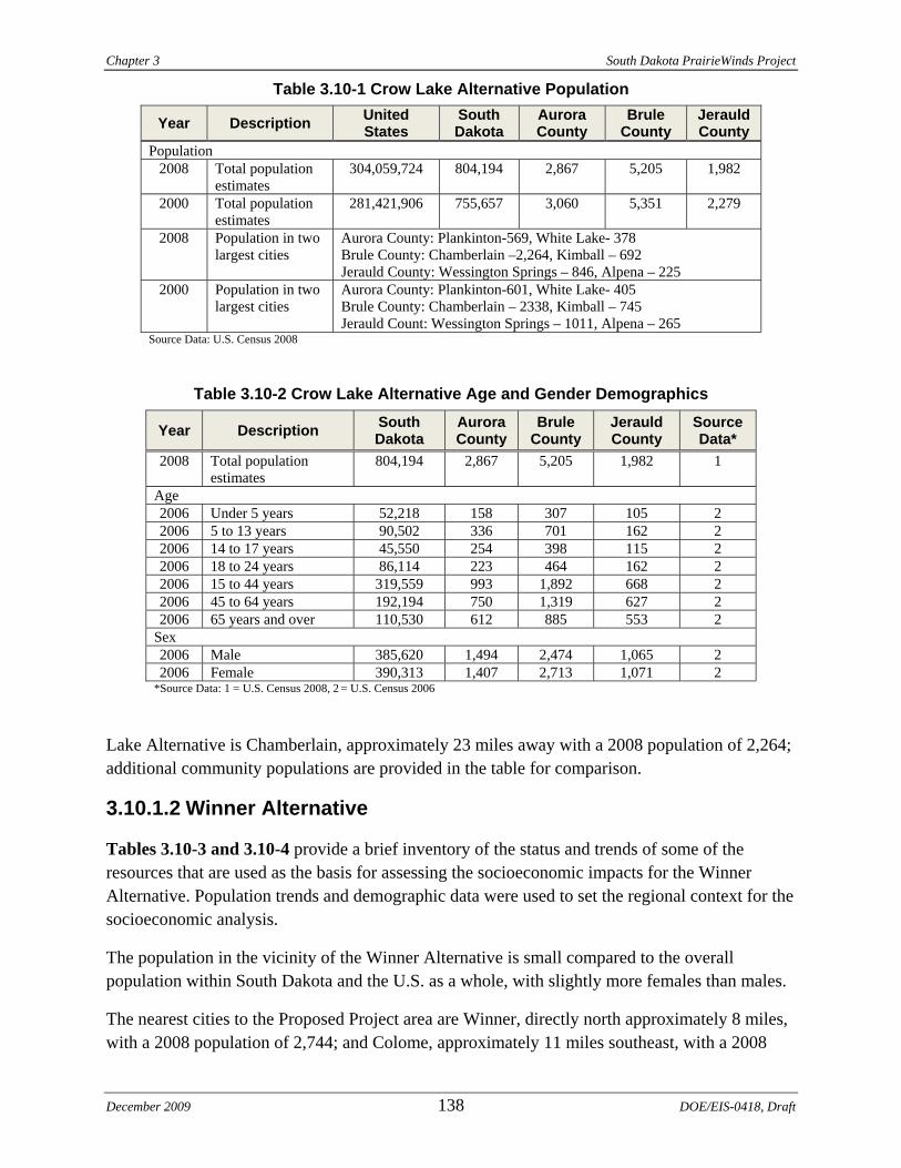
Chapter 3 South Dakota PrairieWinds Project
Table 3.10-1 Crow Lake Alternative Population
Year Description United States
South Dakota
Aurora County
Brule County
Jerauld County
Population 2008 Total population
estimates 304,059,724 804,194 2,867 5,205 1,982
2000 Total population estimates
281,421,906 755,657 3,060 5,351 2,279
2008 Population in two largest cities
Aurora County: Plankinton-569, White Lake- 378 Brule County: Chamberlain –2,264, Kimball – 692 Jerauld County: Wessington Springs – 846, Alpena – 225
2000 Population in two largest cities
Aurora County: Plankinton-601, White Lake- 405 Brule County: Chamberlain – 2338, Kimball – 745 Jerauld Count: Wessington Springs – 1011, Alpena – 265
Source Data: U.S. Census 2008
Table 3.10-2 Crow Lake Alternative Age and Gender Demographics
Year Description South Dakota
Aurora County
Brule County
Jerauld County
Source Data*
2008 Total population estimates
804,194 2,867 5,205 1,982 1
Age 2006 Under 5 years 52,218 158 307 105 2 2006 5 to 13 years 90,502 336 701 162 2 2006 14 to 17 years 45,550 254 398 115 2 2006 18 to 24 years 86,114 223 464 162 2 2006 15 to 44 years 319,559 993 1,892 668 2 2006 45 to 64 years 192,194 750 1,319 627 2 2006 65 years and over 110,530 612 885 553 2
Sex 2006 Male 385,620 1,494 2,474 1,065 2 2006 Female 390,313 1,407 2,713 1,071 2
*Source Data: 1 = U.S. Census 2008, 2 = U.S. Census 2006
Lake Alternative is Chamberlain, approximately 23 miles away with a 2008 population of 2,264; additional community populations are provided in the table for comparison.
3.10.1.2 Winner Alternative
Tables 3.10-3 and 3.10-4 provide a brief inventory of the status and trends of some of the resources that are used as the basis for assessing the socioeconomic impacts for the Winner Alternative. Population trends and demographic data were used to set the regional context for the socioeconomic analysis.
The population in the vicinity of the Winner Alternative is small compared to the overall population within South Dakota and the U.S. as a whole, with slightly more females than males.
The nearest cities to the Proposed Project area are Winner, directly north approximately 8 miles, with a 2008 population of 2,744; and Colome, approximately 11 miles southeast, with a 2008
December 2009 138 DOE/EIS-0418, Draft
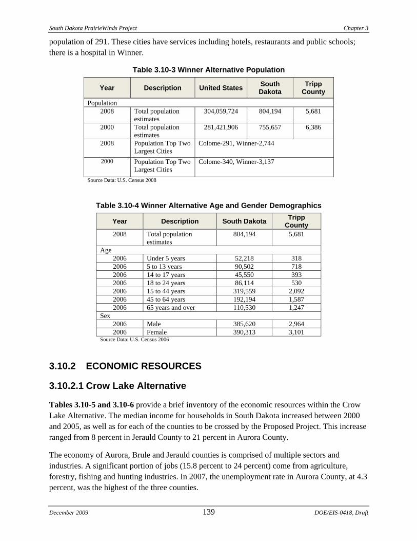
South Dakota PrairieWinds Project Chapter 3
population of 291. These cities have services including hotels, restaurants and public schools; there is a hospital in Winner.
Table 3.10-3 Winner Alternative Population
Year Description United States South Dakota
Tripp County
Population 2008 Total population
estimates 304,059,724 804,194 5,681
2000 Total population estimates
281,421,906 755,657 6,386
Colome-291, Winner-2,744 2008 Population Top Two Largest Cities
Colome-340, Winner-3,137 2000 Population Top Two Largest Cities
Source Data: U.S. Census 2008
Table 3.10-4 Winner Alternative Age and Gender Demographics
Year Description South Dakota Tripp County
2008 Total population estimates
804,194 5,681
Age 2006 Under 5 years 52,218 318 2006 5 to 13 years 90,502 718 2006 14 to 17 years 45,550 393 2006 18 to 24 years 86,114 530 2006 15 to 44 years 319,559 2,092 2006 45 to 64 years 192,194 1,587 2006 65 years and over 110,530 1,247
Sex 2006 Male 385,620 2,964 2006 Female 390,313 3,101
Source Data: U.S. Census 2006
3.10.2 ECONOMIC RESOURCES
3.10.2.1 Crow Lake Alternative
Tables 3.10-5 and 3.10-6 provide a brief inventory of the economic resources within the Crow Lake Alternative. The median income for households in South Dakota increased between 2000 and 2005, as well as for each of the counties to be crossed by the Proposed Project. This increase ranged from 8 percent in Jerauld County to 21 percent in Aurora County.
The economy of Aurora, Brule and Jerauld counties is comprised of multiple sectors and industries. A significant portion of jobs (15.8 percent to 24 percent) come from agriculture, forestry, fishing and hunting industries. In 2007, the unemployment rate in Aurora County, at 4.3 percent, was the highest of the three counties.
December 2009 139 DOE/EIS-0418, Draft
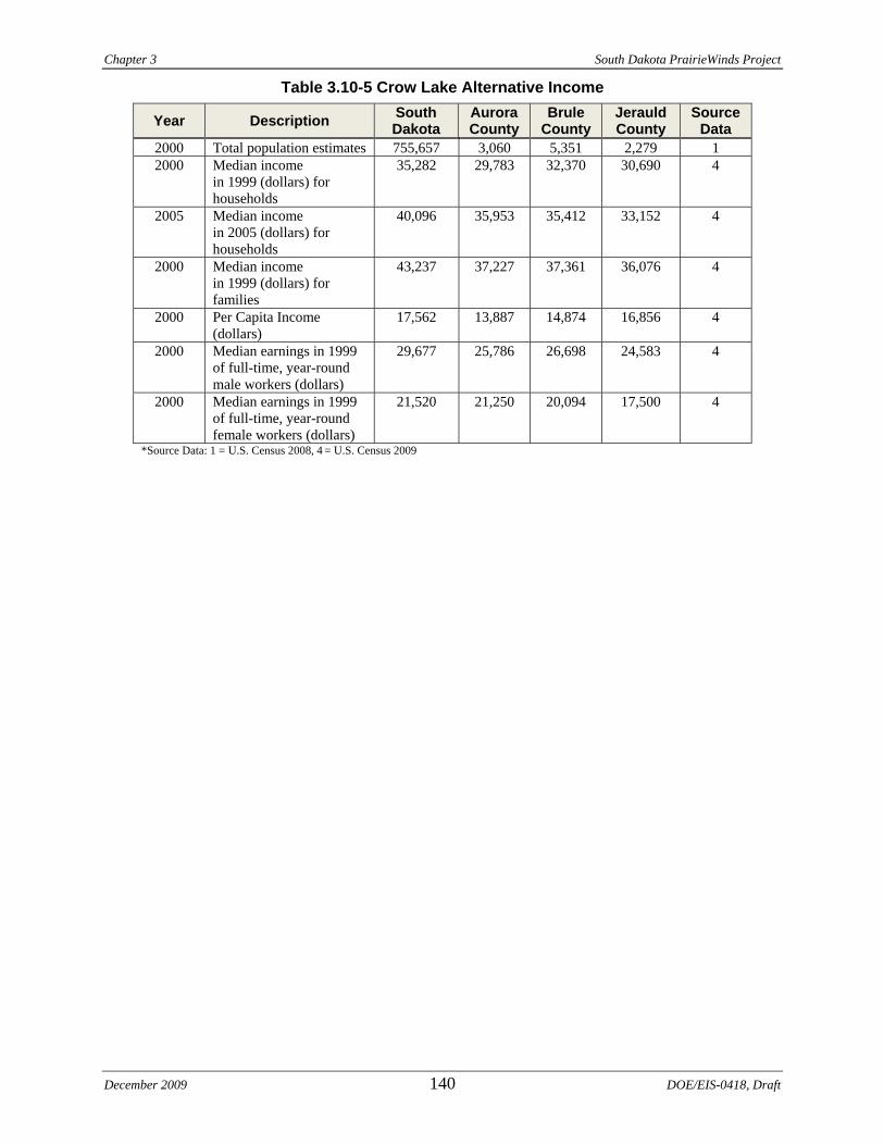
Chapter 3 South Dakota PrairieWinds Project
Table 3.10-5 Crow Lake Alternative Income
Year Description South Dakota
Aurora County
Brule County
Jerauld County
Source Data
2000 Total population estimates 755,657 3,060 5,351 2,279 1 2000 Median income
in 1999 (dollars) for households
35,282 29,783 32,370 30,690 4
2005 Median income in 2005 (dollars) for households
40,096 35,953 35,412 33,152 4
2000 Median income in 1999 (dollars) for families
43,237 37,227 37,361 36,076 4
2000 Per Capita Income (dollars)
17,562 13,887 14,874 16,856 4
2000 Median earnings in 1999 of full-time, year-round male workers (dollars)
29,677 25,786 26,698 24,583 4
2000 Median earnings in 1999 of full-time, year-round female workers (dollars)
21,520 21,250 20,094 17,500 4
*Source Data: 1 = U.S. Census 2008, 4 = U.S. Census 2009
December 2009 140 DOE/EIS-0418, Draft
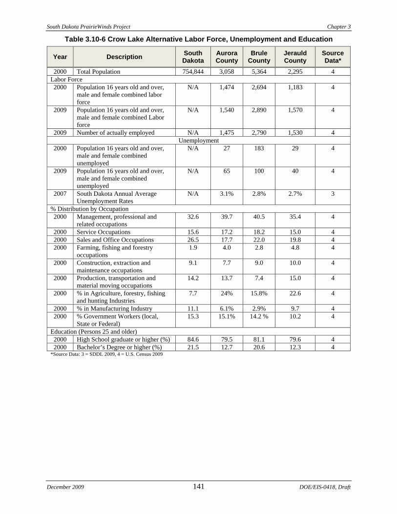
South Dakota PrairieWinds Project Chapter 3
Table 3.10-6 Crow Lake Alternative Labor Force, Unemployment and Education
Year Description South Dakota
Aurora County
Brule County
Jerauld County
Source Data*
2000 Total Population 754,844 3,058 5,364 2,295 4 Labor Force 2000 Population 16 years old and over,
male and female combined labor force
N/A 1,474 2,694 1,183 4
2009 Population 16 years old and over, male and female combined Labor force
N/A 1,540 2,890 1,570 4
2009 Number of actually employed N/A 1,475 2,790 1,530 4 Unemployment
2000 Population 16 years old and over, male and female combined unemployed
N/A 27 183 29 4
2009 Population 16 years old and over, male and female combined unemployed
N/A 65 100 40 4
2007 South Dakota Annual Average Unemployment Rates
N/A 3.1% 2.8% 2.7% 3
% Distribution by Occupation 2000 Management, professional and
related occupations 32.6 39.7 40.5 35.4 4
2000 Service Occupations 15.6 17.2 18.2 15.0 4 2000 Sales and Office Occupations 26.5 17.7 22.0 19.8 4 2000 Farming, fishing and forestry
occupations 1.9 4.0 2.8 4.8 4
2000 Construction, extraction and maintenance occupations
9.1 7.7 9.0 10.0 4
2000 Production, transportation and material moving occupations
14.2 13.7 7.4 15.0 4
2000 % in Agriculture, forestry, fishing and hunting Industries
7.7 24% 15.8% 22.6 4
2000 % in Manufacturing Industry 11.1 6.1% 2.9% 9.7 4 2000 % Government Workers (local,
State or Federal) 15.3 15.1% 14.2 % 10.2 4
Education (Persons 25 and older) 2000 High School graduate or higher (%) 84.6 79.5 81.1 79.6 4 2000 Bachelor’s Degree or higher (%) 21.5 12.7 20.6 12.3 4
*Source Data: 3 = SDDL 2009, 4 = U.S. Census 2009
December 2009 141 DOE/EIS-0418, Draft
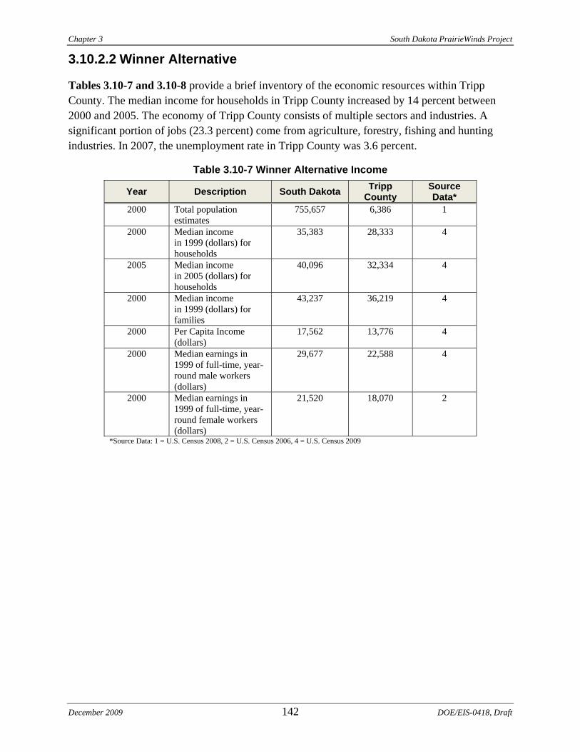
Chapter 3 South Dakota PrairieWinds Project
3.10.2.2 Winner Alternative
Tables 3.10-7 and 3.10-8 provide a brief inventory of the economic resources within Tripp County. The median income for households in Tripp County increased by 14 percent between 2000 and 2005. The economy of Tripp County consists of multiple sectors and industries. A significant portion of jobs (23.3 percent) come from agriculture, forestry, fishing and hunting industries. In 2007, the unemployment rate in Tripp County was 3.6 percent.
Table 3.10-7 Winner Alternative Income
Year Description South Dakota Tripp County
Source Data*
2000 Total population estimates
755,657 6,386 1
2000 Median income in 1999 (dollars) for households
35,383 28,333 4
2005 Median income in 2005 (dollars) for households
40,096 32,334 4
2000 Median income in 1999 (dollars) for families
43,237 36,219 4
2000 Per Capita Income (dollars)
17,562 13,776 4
2000 Median earnings in 1999 of full-time, year-round male workers (dollars)
29,677 22,588 4
2000 Median earnings in 1999 of full-time, year-round female workers (dollars)
21,520 18,070 2
*Source Data: 1 = U.S. Census 2008, 2 = U.S. Census 2006, 4 = U.S. Census 2009
December 2009 142 DOE/EIS-0418, Draft
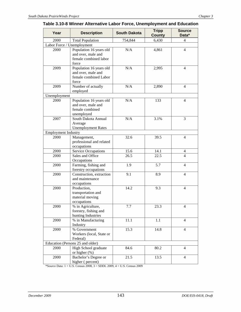
South Dakota PrairieWinds Project Chapter 3
Table 3.10-8 Winner Alternative Labor Force, Unemployment and Education
Year Description South Dakota Tripp County
Source Data*
2000 Total Population 754,844 6,430 4 Labor Force / Unemployment
2000 Population 16 years old and over, male and female combined labor force
N/A 4,861 4
2009 Population 16 years old and over, male and female combined Labor force
N/A 2,995 4
2009 Number of actually employed
N/A 2,890 4
Unemployment 2000 Population 16 years old
and over, male and female combined unemployed
N/A 133 4
2007 South Dakota Annual Average Unemployment Rates
N/A 3.1% 3
Employment Industry 2000 Management,
professional and related occupations
32.6 39.5 4
2000 Service Occupations 15.6 14.1 4 2000 Sales and Office
Occupations 26.5 22.5 4
2000 Farming, fishing and forestry occupations
1.9 5.7 4
2000 Construction, extraction and maintenance occupations
9.1 8.9 4
2000 Production, transportation and material moving occupations
14.2 9.3 4
2000 % in Agriculture, forestry, fishing and hunting Industries
7.7 23.3 4
2000 % in Manufacturing Industry
11.1 1.1 4
2000 % Government Workers (local, State or Federal)
15.3 14.8 4
Education (Persons 25 and older) 2000 High School graduate
or higher (%) 84.6 80.2 4
2000 Bachelor’s Degree or higher ( percent)
21.5 13.5 4
*Source Data: 1 = U.S. Census 2008, 3 = SDDL 2009, 4 = U.S. Census 2009
December 2009 143 DOE/EIS-0418, Draft
Chapter 3 South Dakota PrairieWinds Project
December 2009 144 DOE/EIS-0418, Draft
3.11 ENVIRONMENTAL JUSTICE Executive Order 12898, Federal Actions to Address Environmental Justice in Minority Populations and Low-Income Populations, states that “each Federal agency shall make achieving environmental justice part of its mission by identifying and addressing, as appropriate, disproportionately high and adverse human health or environmental effects of its programs, policies and activities on minority populations and low-income populations.”
This section identifies existing minority populations, low-income populations and tribal communities, defined as follows:
Minority: Individual(s) who are members of the following population groups: American Indian or Alaskan Native; Asian or Pacific Islander; Black, not of Hispanic origin; or Hispanic.
Minority population: Minority populations are either: (a) the minority population of the affected area exceeds 50 percent or (b) the minority population percentage of the affected area is meaningfully greater than the minority population percentage in the general population or other appropriate unit of geographic analysis. In identifying minority communities, agencies may consider as a community either a group of individuals living in geographic proximity to one another, or a geographically dispersed/transient set of individuals (such as migrant workers or Native Americans), where either type of group experiences common conditions of environmental exposure or effect. The selection of the appropriate unit of geographic analysis may be a governing body’s jurisdiction, a neighborhood, census tract or other similar unit that is to be chosen so as to not artificially dilute or inflate the affected minority population. A minority population also exists if there is more than one minority group present and the minority percentage, as calculated by aggregating all minority persons, meets one of the above-stated thresholds.
Low-income population: Low-income populations in an affected area are populations with the annual statistical poverty thresholds from the Bureau of the Census’ Current Population Reports on Income and Poverty. In identifying low-income populations, agencies may use the same criteria used to define a community for minority populations.
The ROI for environmental justice was identified based on census tracts. When first delineated, census tracts were designed to be homogeneous with respect to population characteristics, economic status and living conditions. Census tracts are relatively permanent statistical subdivisions of a county; usually have between 2,500 and 8,000 persons; and are intended to be maintained over a long time so that statistical comparisons can be made from census to census (Census Bureau 2009). The ROI for the Crow Lake Alternative includes the following census tracts: 9731, 9736 and 9746. The ROI for the Winner Alternative includes the following census tracts: 9716 and 9717. Data from the U.S. Census Bureau (U.S. Census 2000a and 200b) was obtained for the identified census tracts to characterize the minority and low income population occupying the ROI near the Proposed Project alternatives, depicted in Figure 3.11-1.
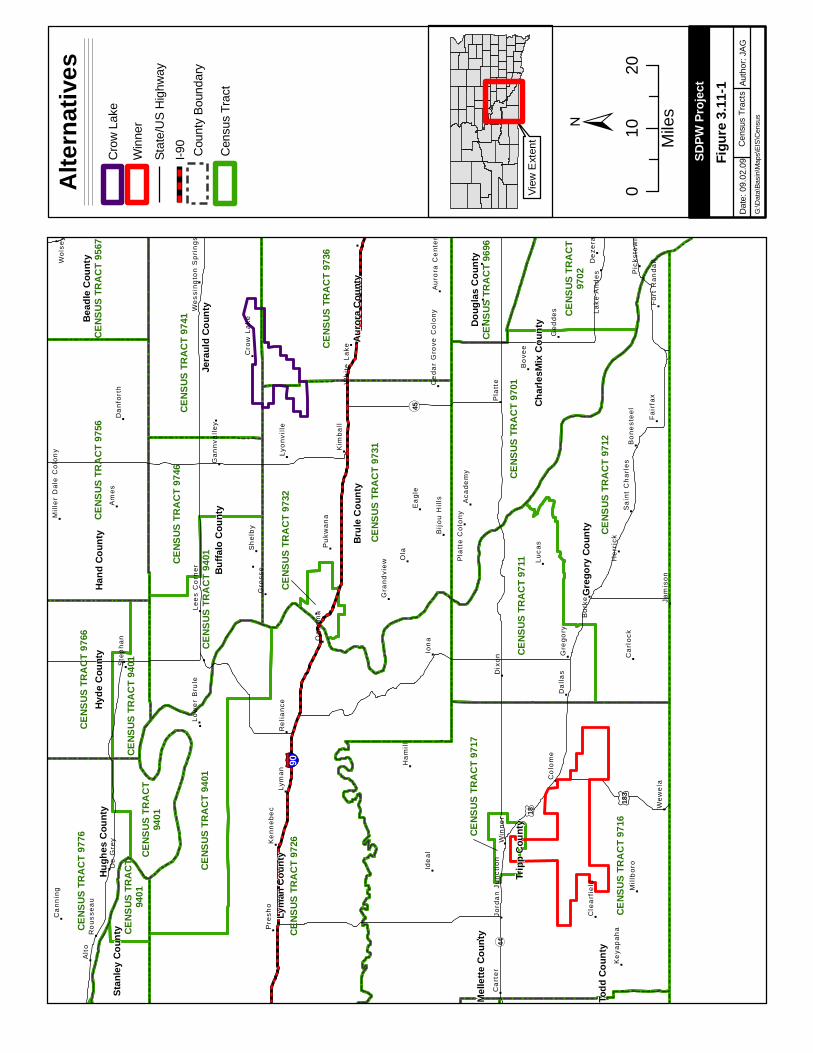
"
"
"
"
"
"
"
"
"
"
"
"
"
"
"
"
"
"
""
"
"
"
"
"
"
""
"
"
"
"
"
"
"
"
"
""
"
"
"
"
"
"
"
""
"
""
"
"
"
"
"
"
"
"
"
"
"
"
"
"
"
"
"
"
"
"
"
"
"
"
"
"
"
"
"
"
"
"
"
"
"
"
§̈ ¦90
¬ «44
¬ «45
£ ¤18
£ ¤183
CENS
US TR
ACT 9
716
CENS
US TR
ACT 9
726
CENS
US TR
ACT 9
731
CENS
US TR
ACT 9
712
CENS
US TR
ACT 9
736
CENS
US TR
ACT 9
756
CENS
US TR
ACT 9
701
CENS
US TR
ACT 9
741
CENS
US TR
ACT 9
711
CENS
US TR
ACT 9
401
CENS
US TR
ACT 9
776
CENS
US TR
ACT 9
401CENS
US TR
ACT 9
746
CENS
US TR
ACT 9
766
CENS
US TR
ACT 9
567
CENS
US TR
ACT 9
696
CENS
US TR
ACT
9401
CENS
US TR
ACT 9
401
CENS
US TR
ACT
9702
CENS
US TR
ACT
9401
CENS
US TR
ACT 9
732
CENS
US TR
ACT 9
717
Tripp
Cou
nty
Lyma
n Cou
nty
Greg
ory C
ount
y
Brule
Cou
nty
Hand
Cou
nty
Charl
esMi
x Cou
nty
Auro
ra C
ounty
Buffa
lo Co
unty
Jera
uld C
ount
y
Hugh
es C
ounty
Hyde
Cou
ntyBe
adle
Coun
ty
Doug
las C
ount
y
Stan
ley C
ount
y
Todd
Cou
nty
Melle
tte C
ount
y
Ola
Ion
a
Am
es
Alt
o
Lym
an
Luca
s
Ide
al
Ea
gle
Dix
on
Bu
rke
Bo
vee
Wol
sey
Win
ner
Wew
ela
Sh
elb
y
Pre
sho
Pla
tte
Oac
om
a
Ha
mil
l
Gro
sse
Ged
des
De
zera
Da
llas
Co
lom
e
Ca
rter
Jam
ison
Ste
pha
n
Pu
kwan
a
Kim
ball
He
rric
k
Gre
gory
Fai
rfax
De
Gre
y
Ca
rloc
k
Ca
nnin
g
Aca
dem
y
Ro
usse
au
Re
lianc
e
Mill
bor
o
Ke
yap
aha
Ke
nneb
ec
Da
nfor
th
Pic
ksto
wn
Lyo
nvil
le
Gra
ndvi
ew
Cro
w L
ake
Bo
nest
eel
Wh
ite
Lak
e
Lake
And
es
Gan
nva
lley
Cle
arf
ield
Low
er
Bru
leLe
es
Co
rner
Bij
ou H
ills
For
t R
anda
ll
Sa
int
Ch
arle
s
Pla
tte
Co
lony
Au
rora
Ce
nte
r
Jord
an
Junc
tio
n
Wes
sing
ton
Sp
rin
gs
Mill
er
Dal
e C
olo
ny
Ce
dar
Gro
ve C
olon
y
±
Alter
nativ
es
010
20
Mile
s
Papa
go R
dD
ate:
09.
02.0
9Au
thor
: JA
GG
:\Dat
a\Ba
sin\
Map
s\EI
S\C
ensu
s
SDPW
Proje
ct
Cen
sus
Trac
ts
View
Ext
ent
Cro
w L
ake
Figur
e 3.11
-1
Win
ner
Stat
e/U
S H
ighw
ay
I-90
Cou
nty
Boun
dary
Cen
sus
Trac
t
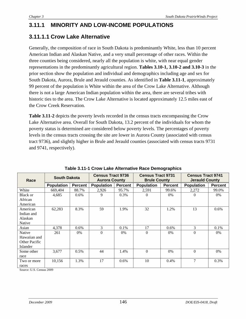
Chapter 3 South Dakota PrairieWinds Project
3.11.1 MINORITY AND LOW-INCOME POPULATIONS
3.11.1.1 Crow Lake Alternative
Generally, the composition of race in South Dakota is predominantly White, less than 10 percent American Indian and Alaskan Native, and a very small percentage of other races. Within the three counties being considered, nearly all the population is white, with near equal gender representations in the predominantly agricultural region. Tables 3.10-1, 3.10-2 and 3.10-3 in the prior section show the population and individual and demographics including age and sex for South Dakota, Aurora, Brule and Jerauld counties. As identified in Table 3.11-1, approximately 99 percent of the population is White within the area of the Crow Lake Alternative. Although there is not a large American Indian population within the area, there are several tribes with historic ties to the area. The Crow Lake Alternative is located approximately 12.5 miles east of the Crow Creek Reservation.
Table 3.11-2 depicts the poverty levels recorded in the census tracts encompassing the Crow Lake Alternative area. Overall for South Dakota, 13.2 percent of the individuals for whom the poverty status is determined are considered below poverty levels. The percentages of poverty levels in the census tracts crossing the site are lower in Aurora County (associated with census tract 9736), and slightly higher in Brule and Jerauld counties (associated with census tracts 9731 and 9741, respectively).
Table 3.11-1 Crow Lake Alternative Race Demographics
Race South Dakota Census Tract 9736 Aurora County
Census Tract 9731 Brule County
Census Tract 9741 Jerauld County
Population Percent Population Percent Population Percent Population Percent White 669,404 88.7% 2,926 95.7% 2,591 99.6% 2,272 99.0% Black or African American
4,685 0.6% 9 0.3% 0 0% 0 0%
American Indian and Alaskan Native
62,283 8.3% 59 1.9% 32 1.2% 13 0.6%
Asian 4,378 0.6% 3 0.1% 17 0.6% 3 0.1% Native Hawaiian and Other Pacific Islander
261 0% 0 0% 0 0% 0 0%
Some other race
3,677 0.5% 44 1.4% 0 0% 0 0%
Two or more races
10,156 1.3% 17 0.6% 10 0.4% 7 0.3%
Source: U.S. Census 2009
December 2009 146 DOE/EIS-0418, Draft
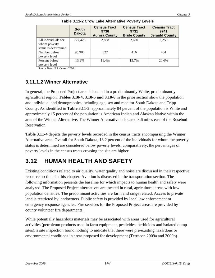
South Dakota PrairieWinds Project Chapter 3
Table 3.11-2 Crow Lake Alternative Poverty Levels
South Dakota
Census Tract 9736
Aurora County
Census Tract 9731
Brule County
Census Tract 9741
Jerauld County All individuals for whom poverty status is determined
727,425 2,858 2,650 2,250
Number below poverty level
95,900 327 416 464
Percent below poverty level
13.2% 11.4% 15.7% 20.6%
Source Data: U.S. Census 2000b
3.11.1.2 Winner Alternative
In general, the Proposed Project area is located in a predominantly White, predominantly agricultural region. Tables 3.10-4, 3.10-5 and 3.10-6 in the prior section show the population and individual and demographics including age, sex and race for South Dakota and Tripp County. As identified in Table 3.11-3, approximately 84 percent of the population is White and approximately 15 percent of the population is American Indian and Alaskan Native within the area of the Winner Alternative. The Winner Alternative is located 8.6 miles east of the Rosebud Reservation.
Table 3.11-4 depicts the poverty levels recorded in the census tracts encompassing the Winner Alternative area. Overall for South Dakota, 13.2 percent of the individuals for whom the poverty status is determined are considered below poverty levels, comparatively, the percentages of poverty levels in the census tracts crossing the site are higher.
3.12 HUMAN HEALTH AND SAFETY Existing conditions related to air quality, water quality and noise are discussed in their respective resource sections in this chapter. Aviation is discussed in the transportation section. The following information presents the baseline for which impacts to human health and safety were analyzed. The Proposed Project alternatives are located in rural, agricultural areas with low population densities. The predominant activities are farm and range related. Access to private land is restricted by landowners. Public safety is provided by local law enforcement or emergency response agencies. Fire services for the Proposed Project areas are provided by county volunteer fire departments.
While potentially hazardous materials may be associated with areas used for agricultural activities (petroleum products used in farm equipment, pesticides, herbicides and isolated dump sites), a site inspection found nothing to indicate that there were pre-existing hazardous or environmental conditions in areas proposed for development (Terracon 2009a and 2009b).
December 2009 147 DOE/EIS-0418, Draft
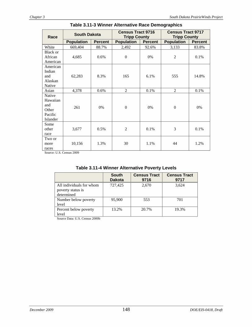
Chapter 3 South Dakota PrairieWinds Project
December 2009 148 DOE/EIS-0418, Draft
Table 3.11-3 Winner Alternative Race Demographics
Race South Dakota Census Tract 9716 Tripp County
Census Tract 9717 Tripp County
Population Percent Population Percent Population Percent White 669,404 88.7% 2,492 92.6% 3,133 83.8% Black or African American
4,685 0.6% 0 0% 2 0.1%
American Indian and Alaskan Native
62,283 8.3% 165 6.1% 555 14.8%
Asian 4,378 0.6% 2 0.1% 2 0.1% Native Hawaiian and Other Pacific Islander
261 0% 0 0% 0 0%
Some other race
3,677 0.5% 2 0.1% 3 0.1%
Two or more races
10,156 1.3% 30 1.1% 44 1.2%
Source: U.S. Census 2009
Table 3.11-4 Winner Alternative Poverty Levels South
Dakota Census Tract
9716 Census Tract
9717 All individuals for whom poverty status is determined
727,425 2,670 3,624
Number below poverty level
95,900 553 701
Percent below poverty level
13.2% 20.7% 19.3%
Source Data: U.S. Census 2000b