Embed Size (px)
Citation preview
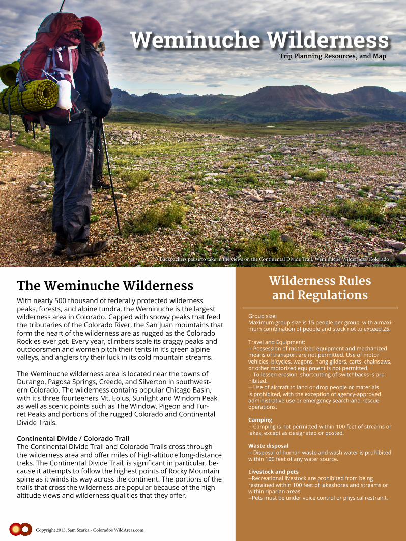
Weminuche Wilderness
Wilderness Rulesand RegulationsWith nearly 500 thousand of federally protected wilderness
peaks, forests, and alpine tundra, the Weminuche is the largest wilderness area in Colorado. Capped with snowy peaks that feed the tributaries of the Colorado River, the San Juan mountains that form the heart of the wilderness are as rugged as the Colorado Rockies ever get. Every year, climbers scale its craggy peaks and outdoorsmen and women pitch their tents in it’s green alpine valleys, and anglers try their luck in its cold mountain streams.
The Weminuche wilderness area is located near the towns of Durango, Pagosa Springs, Creede, and Silverton in southwest-ern Colorado. The wilderness contains popular Chicago Basin, with it’s three fourteeners Mt. Eolus, Sunlight and Windom Peak as well as scenic points such as The Window, Pigeon and Tur-ret Peaks and portions of the rugged Colorado and Continental Divide Trails.
Continental Divide / Colorado TrailThe Continental Divide Trail and Colorado Trails cross through the wilderness area and offer miles of high-altitude long-distance treks. The Continental Divide Trail, is significant in particular, be-cause it attempts to follow the highest points of Rocky Mountain spine as it winds its way across the continent. The portions of the trails that cross the wilderness are popular because of the high altitude views and wilderness qualities that they offer.
The Weminuche Wilderness
Copyright 2015, Sam Szarka - Colorado’s WildAreas.com
Backpackers pause to take in the views on the Continental Divide Trail, Weminuche Wilderness, Colorado
Group size:Maximum group size is 15 people per group, with a maxi-mum combination of people and stock not to exceed 25.
Travel and Equipment: -- Possession of motorized equipment and mechanized means of transport are not permitted. Use of motor vehicles, bicycles, wagons, hang gliders, carts, chainsaws, or other motorized equipment is not permitted.-- To lessen erosion, shortcutting of switchbacks is pro-hibited.-- Use of aircraft to land or drop people or materials is prohibited, with the exception of agency-approved administrative use or emergency search-and-rescue operations.
Camping-- Camping is not permitted within 100 feet of streams or lakes, except as designated or posted.
Waste disposal-- Disposal of human waste and wash water is prohibited within 100 feet of any water source.
Livestock and pets--Recreational livestock are prohibited from being restrained within 100 feet of lakeshores and streams or within riparian areas.--Pets must be under voice control or physical restraint.
Trip Planning Resources, and Map
Wilderness Rulesand Regulations
Managing US Forest Service Offices
Rio Grande National Forest1803 W HWY 160MONTE VISTA, CO 81144 Phone: 719-852-5941
San Juan National Forest15 BURNETT COURTDURANGO, CO 81301 Phone: 970-247-4874
Weather
National Weather Service Grand Junction Office2844 Aviators WayGrand Junction, CO 81506-8644970-243-7007
Maps
7.5 Minute USGS Quad MapsHowardsville, Pole Creek Mountain, Snowdon Peak, Storm King PeakMountain View Crest, Columbine Pass, Weminuche Pass, Granite Lake,Little Squaw Creek, Cimarrona Peak, Workman Creek, Palomino Mountain, South River Peak, Mount Hope, Lemon Reservoir, Vallecitor Reservoir, Granite Peak, Bear Mountain, Oakbrush Ridge, Pagosa Peak, Saddle Mountain, Wolf Creek Pass
Durango & Silverton Railroad
The Durango & Silverton Railroad offers access to the Elk Park and Needleton trailhead flagstops from early May into mid-October. Please visit their website forrates and arrival/departure information.
Other / Trip Planning
Copyright 2015, Sam Szarka - ColoradosWildAreas.com
Subarea/Site Specific Regulations
Camping Prohibited-- Archuleta, Fourmile , West Ute Lake: within 200 feet of lake-- Emerald Lake: within 1/2 mile of north shore and 1/4 mile of other shores-- Little Emerald Lake: within 1/4 mile of lake-- Flint Lake: between shore and Flint and La Osa Trails; and within 200 feet of west and north shores-- Twin Lakes: in Needle Creek drainage-- West Fork (Rainbow): in the hot springs area
Campfires Prohibited (no Campfires or Wood Stoves)-- Emerald Lake: within 1/2 mile of north shore and 1/4 mile of other shores-- Little Emerald Lake: within 1/4 mile of lake-- Flint Lake: between shore and Flint and La Osa Trails; and within 200 feet of west and north shores-- Needle Creek Drainage: including Chicago Basin-- Twin Lakes: in Needle Creek drainage-- Vestal Basin-- West Fork (Rainbow): in hot springs area
-- Recreational livestock are prohibited from being restrained within 100 feet of lakeshores and streams or within riparian areas.
Stock FeedAll feed must be weed-free certified in Colorado, Idaho, Montana, Nebraska, Wyoming, or Utah and be marked with certified twine, packing or transit certificate. Only the following are allowed:
-- Weed-free baled hay-- Cubed or pelletized hay-- Steamed grain in a processor’s stamped bag-- Weed-free baled mulch made from tree fibers or steamed material.
Stock Use Restriction - No Hitching or TetheringHitching or tethering a horse or other saddle or pack an-imal in violation of posted instructions is prohibited. Rec-reational livestock are prohibited from being restrained within 100 feet of streams or lakes. Hitching or tethering a horse or other saddle or pack animal is prohibited:
-- Archuleta Lake: within 200 feet of lake-- Flint Lake: between shore and Flint and La Osa Trails; and within 200 feet of west and north shores-- Fourmile Lake: within 200 feet of lake-- West Ute Lake: within 200 feet of lake
Stock Use Restriction - Grazing Prohibited
-- Archuleta Lake: within 200 feet of lake-- Emerald Lake: within 1/2 mile of north shore and 1/4 mile of other shores-- Little Emerald Lake: within 1/4 mile of lake-- Flint Lake: between shore and Flint and La Osa Trails; and within 200 feet of west and north shores.-- Fourmile Lake: within 200 feet of lake-- meadow at junction of Weminuche and East Fork Trails-- West Fork (Rainbow): Hot springs area-- West Ute Lake: within 200 feet of lake
Trip Planning Resources
USFS Weminuche Wilderness Planning Portal
http://www.crh.noaa.gov/gjt/
Durango - Silverton Railroad Wilderness Access
Telluride - Silverton - Ouray Trails - Latitude 40 Maps
Trails Illustrated Weminuche Wilderness Map (National Geographic)San Juan National Forest Map
Hiking Colorado’s Weminuche & South San Juan Wilderness Areas Falcon Guide
NWS Weather Forecast for Silverton, Colorado
Wilderness rules and regulations from Wilderness.net
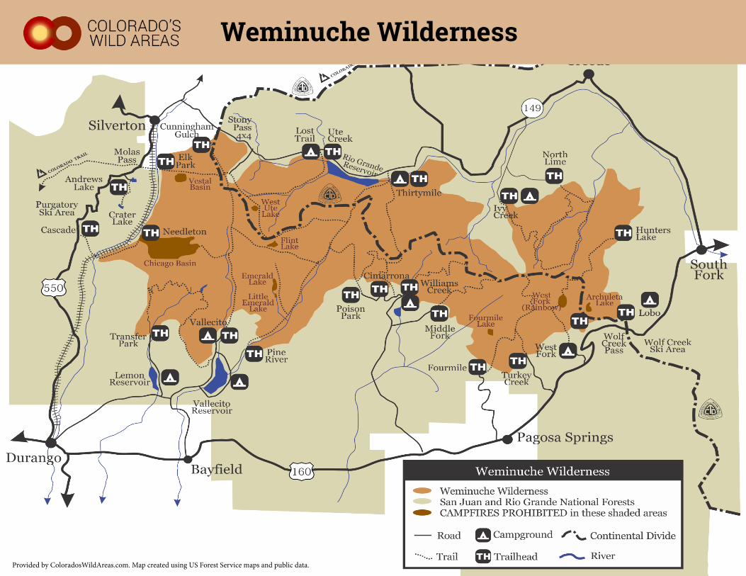
Provided by ColoradosWildAreas.com. Map created using US Forest Service maps and public data.
Weminuche Wilderness