Embed Size (px)
Citation preview
[email protected] (212) 319-3750 WWW.CBSIX.ORG
MOLLY HOLLISTER JESÚS PÉREZ CHAIR DISTRICT MANAGER
CLAUDE L. WINFIELD, FIRST VICE CHAIR BRIAN VAN NIEUWENHOVEN, TREASURER AHSIA BADI, SECOND VICE CHAIR BEATRICE DISMAN, ASST. TREASURER
AMELIA ACOSTA, SECRETARY SEEMA SHAH, ASST. SECRETARY
THE CI T Y O F N E W YO RK MA N HA TT A N CO M MU NI TY BO A RD S I X 211 EA S T 43 RD ST R EE T , SU I TE 1404
NE W YO RK , NY 10017
VIA E-MAIL
June 26, 2019
Marisa Lago, Chair City Planning Commission 120 Broadway, 31st Floor New York, NY 10271
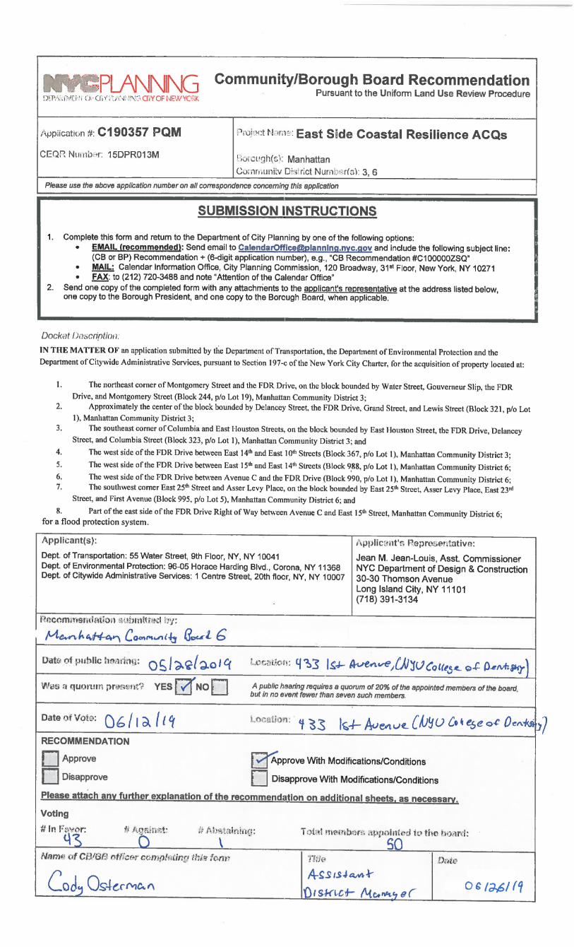
Resolution on ULURP applications N 190356 ZRM & N 190357 PQM by the City of New York for the necessary land acquisitions and zoning changes required for the East Side Coastal Resiliency Project in Community District Six
At the June 12, 2019 Full Board meeting of Manhattan Community Board Six, the Board adopted the following resolution:
WHEREAS, in late October of 2012 Superstorm Sandy caused widespread damage to the City of New York, disrupting service to critical transportation, power, communications and medical infrastructure which adversely affected tens of thousands of residents of Manhattan Community District 6 (CD 6);
WHEREAS, the City of New York was awarded $335 million to evaluate and develop an integrated coastal protection for the 2.2 mile stretch from Montgomery Street to East 25th Street along the East River, which correspond to the 100 year floodplain boundaries through the East Side Coastal Resiliency Project (ESCR);
WHEREAS, the ESCR scope was divided into two separate project areas, with Project Area 2 extending from East 13th Street to East 23rd Street, which was later expanded to East 25th street after detailed analysis of the site conditions around Asser Levy Recreation Center;
WHEREAS, Superstorm Sandy’s East River surge flooded or disabled power and services in a large area of CD 6 south of East 33rd Street and east of 3rd Avenue;
WHEREAS, studies and designs for remediating such “hundred-year” storms began soon after, with the US Department of Housing and Urban Development (HUD) providing $335 million in seed money for a finished flood barrier between Montgomery Street and East 25th Street;
WHEREAS, Manhattan Community Board Six (CB6) recognizes that flood control is a paramount issue, and commends the Department of Design and Construction (DDC) for developing flood-mitigation designs that seem largely capable of addressing the problem;
WHEREAS, DDC plans to protect against future superstorms and flooding by; building a flood barrier along the entire length of the ESCR project areas, taking the form of raised open space, flood walls or deployable gates;
2
WHEREAS, DDC’s plans for construction and mitigation around the construction, now projected to take as long as five years, include restricting access to the waterfront in CD 6 in stages, except for the NYC Ferry landing at Stuyvesant Cove, for the duration of construction; WHEREAS, CD 6 has the lowest amount of open space per capita of any community district in the City of New York, and of that open space a large portion—including Stuyvesant Cove Park, Murphy’s Brother’s Playground, and Asser Levy Park—will be affected and closed by construction lasting between two and five years; WHEREAS, the Manhattan Waterfront Greenway (Greenway) from East 34th St south to Montgomery Street has become a major bicycle transit corridor, as well as a source of exercise and recreation for thousands of users; WHEREAS, DDC improvements slated for the Greenway, after considerable feedback from the Board and the public at large, now includes a flyover bridge to address the perennially dangerous conditions at the Consolidated Edison (ConEd) plant’s waterfront “pinch point” between East 15th and East 13th Streets; WHEREAS, remediating the perilous narrowing of the open space alongside the ConEd plant has been a top priority of CB6’s for over 20 years; WHEREAS, members of CB6 have frequently and explicitly expressed concerns around preliminary construction staging plans for total closure to Stuyvesant Cove Park during construction of the surge barriers and the flyover bridge because of a reluctance of DDC to close any portion of the FDR Drive for any significant length of time; WHEREAS, DDC plans to bisect Asser Levy Park with a flood-control wall and sliding gate, protecting the landmarked bath house but leaving the playing fields unprotected and East 25th Street susceptible to tidal surging and flooding; WHEREAS, where the planned permanent and rolling flood barriers are aligned to cross the FDR Drive Exit 7 ramp connecting to the fixed flood barriers, is a perilous, multi-leg pedestrian pathway with inadequate signage to get from Avenue C to Stuyvesant Cove Park and the ferry landing; WHEREAS, on the East 20th St median between the easternmost end of the 20th Street Loop into Stuyvesant Town and Avenue C, DDC plans to build a 10’ x 60 ’x 10’ interceptor gate house, which will close storm drain pipes to reroute incoming waters during flooding into deeper culverts and thereby avoid turning areas behind the coastal protections into “bathtubs”; WHEREAS, after months of negotiations, the ESCR design team has stated that this project’s large scope and long timeline requires that construction be phased to ensure that people can still access portions of the waterfront park throughout the duration of the project; THEREFORE, BE IT RESOLVED that Manhattan Community Board Six, recognizing the overwhelming dangers posed by superstorm flooding, generally supports the ESCR Project plan for flood mitigation, but has serious concerns which are detailed below that should be fully addressed during the ongoing Uniform Land Use Review Procedure process:
● A detailed plan for noise and dust mitigation all along the construction area, which abuts Stuyvesant Town, Peter Cooper Village, and Waterside Plaza, home to tens of thousands of CD 6 residents;
● Presentation of an operational plan for ambulance access to the First Avenue “hospital row” corridor when barriers are deployed and water runs around the protected Asser Levy Bathhouse and west along East 25th Street and floods First Avenue as it did in 2012;
3
● A DOT plan addressing the recently narrowed lanes of traffic on East 20th Street that allows for passage along East 20th street during the construction of the interceptor gate house;
● A comprehensive plan on emergent and non-emergent access to Waterside Plaza and adjacent schools when ESCR barriers are fully deployed;
BE IT FURTHER RESOLVED that the Board, after years of discussions on the evolving ESCR plan and based on community comment at our public hearing, has further design commentary that would improve the quality of life for waterfront users during and after the projected construction timeline, including:
● The ESCR Project must institute a phased construction timeline for the good of all waterfront users, to prevent unexpected access delays such as those that occurred during the West Street Overpass;
● In addition to a phased construction schedule, the ESCR Project team should develop additional mitigation strategies that focus on providing access to amenities at existing locations in the district that should include both active uses like exercise or game areas, free for activity spaces for children, and passive elements like landscaping and places to sit and relax;
● Improved activation of Waterside Pier with active and passive recreational spaces; activating the parking area under the FDR from East 18th Street to East 23rd Street in ways similar to the current setup at Two Bridges; exploration of the creation of a temporary space on the top level of the Waterside Pier parking garage; the possible use of temporary barges, anchored off existing park areas like Slivka Park and Pier 36, to provide additional active or passive use space;
● Since the current waterfront is a major pathway for both pedestrians, runners and cyclists alike, and CB6’s independent usage counts showed higher usage counts than what was listed in the Draft Environmental Impact Statement, any route detours should accommodate adequate space on the streets to ensure safe movement for the additional multimodality uses with the current sidewalk pedestrians;
● Traffic studies regarding expansion of the NYC Summer Streets program to explore the possible use of any underutilized streets, during summer weekends, when waterfront usage peaks;
● As the securing of funding for a flyover bridge at the pinch point and preparations for its construction are now guaranteed, the protraction of its schedule which isn’t to begin until the other parts of the ESCR are in place is an unnecessary disruption to the use of the waterfront and we expect the ESCR revisit the staging plan and look at ways to begin the flyover bridge construction contemporaneously with its north and south improvements;
● Design consideration should be made for expanded capacity along Captain Patrick J. Brown walk to accommodate for increased walkway usage;
● CB6 strongly recommends that a feasibility study of “decking” portions of the FDR to provide added parkland for the area be included in the design review to better inform possible future projects;
● The installation of a comfort station at Murphy’s Brothers’s Playground rather than simply laying the groundwork for installation at a later date by exploring low cost design options implemented in other cities, such as the Portland Loo, which would allow for a faster implementation and provide immediate upgrades for the users of the park;
● CB6 supports the provision of a new crosswalk at the intersection of Avenue C and the north side of FDR Drive Exit 7 creating a more direct pedestrian access pathway across Avenue C to the waterfront and Stuyvesant Cove Ferry Landing, and that the exit ramp be modified to
4
provide a legal left turn onto Avenue C at the East 18th Street traffic signal; with appropriate signage and signaling to improve alignment with the flood barrier, improve pedestrian safety, and allow for a less circuitous route for westbound and southbound exiting traffic;
● CB6 recommends a comprehensive redesign of the East 20th St bike lane, which was originally designed around a now-obsolete L train mitigation plan, to facilitate faster construction of the interceptor gate house there, unless an alternative gate house site is found;
● That the East 20th Street interceptor gate house be designed with contextually appropriate materials to reflect the historical significance of Peter Cooper Village/Stuyvesant Town and the previous Gas House District;
● That the ESCR Project team should provide supporting data on the cost-benefit analysis done for the proposed Project Area 2 construction plan that would, as was presented, provide a more expedient construction completion than one that includes a partial closure of the FDR Drive;
● As the ESCR plan indicates the flood barrier is west of Stuyvesant Cove Park, sufficient funding should be put aside to rebuild the park after any subsequent destruction from flooding, further diminishing the very limited park space available in CD 6;
● Preservation of the East River Park Fire Boat House should be included so that the Lower East Side Ecology Center is able to continue its important initiatives on the very germane topic of environmental awareness;
● CB6 recommends that interpretive signage and public art installations be incorporated at various points to provide differentiation, historical context and maintain neighborhood identity along the waterfront;
● The inclusion of a robust social media strategy should also be implemented to communicate ongoing park closures and project status updates.
VOTE: 43 in Favor 0 Opposed 1 Abstention 0 Not Entitled Best regards,
Jesús Pérez District Manager Cc: Hon. Gale Brewer, Manhattan Borough President Hon. Carlina Rivera, Council Member Hon. Keith Powers, Council Member Sandro Sherrod, Chair, CB6 Land Use & Waterfront Committee Bob Tuttle, City Planner, New York City Department of City Planning Scott Williamson, City Planner, New York City Department of City Planning Fay Lee, Borough Outreach Coordinator, NYC Department of Design and Construction Gabrielle Dann-Allel, Manhattan Borough Director, Mayor's Community Affairs Unit