Embed Size (px)
Citation preview
D r a f t W h i t t l e s e a G r e e n W e d g e M a n a g e m e n t P l a n 2 0 1 1 - 2 0 2 1 31
LAN
D
D r a f t W h i t t l e s e a G r e e n W e d g e M a n a g e m e n t P l a n 2 0 1 1 - 2 0 2 1
2.1 ObjectiveThe objective for this sub-theme is:
Rural land stewardship objective
To support and promote the local capacity of communities and individuals to actively manage and sustain the Whittlesea Green Wedge through informed land stewardship practices.
Policy, education and regulation will emphasise the ‘duty of care’ to all landholders and land managers, but will also recognise the particular difficulties of managing land at the metropolitan interface and the need for assistance and resourcing from all levels of Government.
2.2 Features and ValuesGood rural land stewardship practices provide valuable environmental, social and economic benefits for residents and visitors alike.
Modern agricultural practices need to be flexible in order to achieve traditional functions (such as food production), provide land stewardship in order to sustain the land, contribute to environmental services and the social capital of rural communities, whilst contributing to economic development and employment.
2.2.1 Sustainable Land ManagementThe notion of sustainable land management is embraced under the definition of Ecological Sustainable Development (ESD), which is defined as using, conserving and enhancing the community’s resources so that ecological processes, on which life depends, are maintained, and the total quality of life, now and in the future, can be increased (Commonwealth Government 1992).
Essentially, ESD is about maintaining the long-term environmental/social/cultural viability of the land and its natural resources. This concept is explored in greater depth in the land management review of the municipality's rural sector titled Sustainable Farm and Land Management Support Programs (City of Whittlesea 2005).
As our knowledge of ecosystems and the benefits of native vegetation increases, there is a growing urgency to restore degraded ecosystems and protect what remains in order to maintain ‘ecological services’ that are fundamental to the quality of human life and the economy.
For Whittlesea, this means adopting farming systems and land management practices which aim to maintain and enhance natural systems in order that economic viability can be sustained.
Increasingly, the value of services provided to the community by natural systems is being recognised (Binning et al. 2001). This includes understanding that the environment provides services that if unavailable, would incur significant economic and social cost. This includes water filtration, insect pest control, pollination, soil health, maintenance of healthy waterways and breakdown of waste. Less tangible benefits include cultural and spiritual meaning, landscape beauty and a sense of place. The wellbeing of individuals and communities is dependent upon ecosystem services.
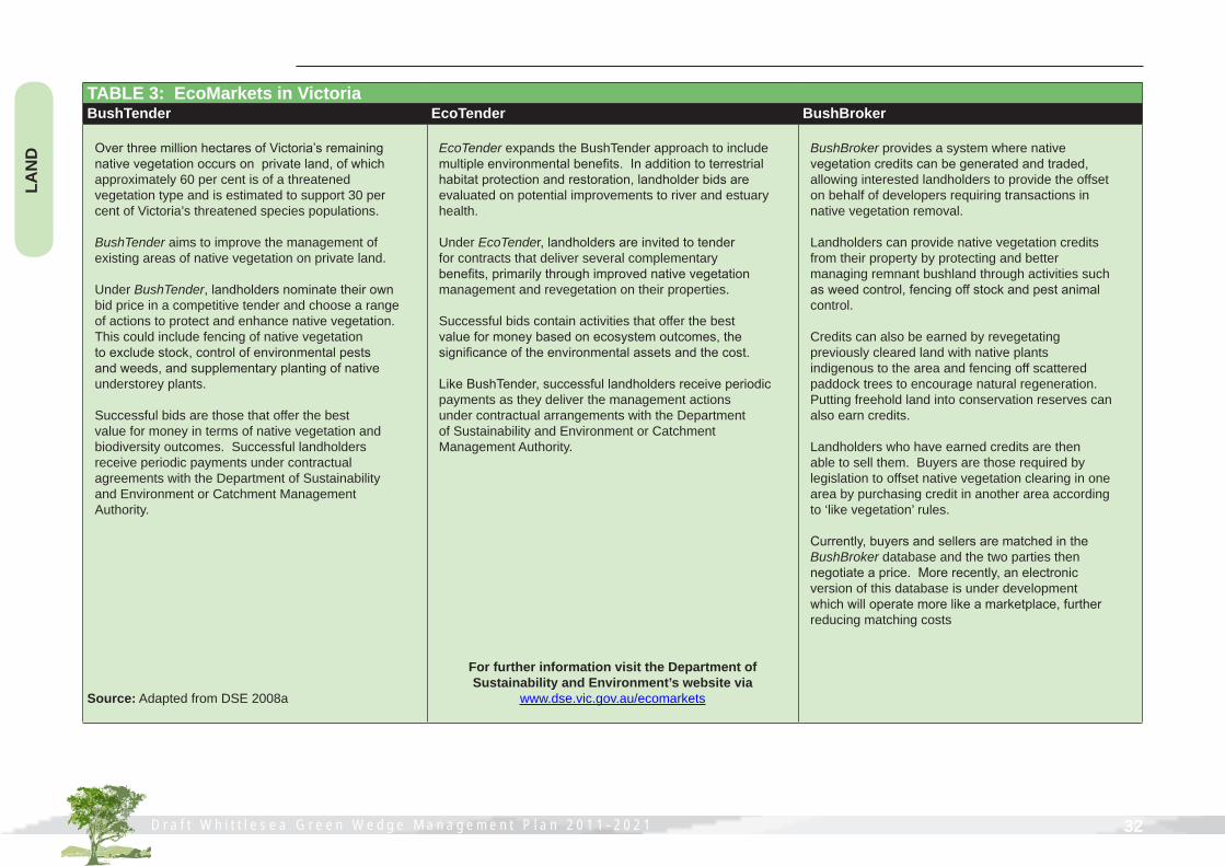
2.2.2 EcoMarketsMarkets are emerging that offer landholders the opportunity to earn an income by providing environmental services on their land. EcoMarkets is a term used to describe a range of market-based systems that aim to address environmental decline. Emerging market options currently available through the Department of Sustainability and Environment are outlined in Table 3 over the page.
These market-based instruments use the economic principles of market trade to maintain or improve the natural environment. Yet this is not about locking up farms from stock or cropping activities. It is about paying farmers to manage native vegetation on their property and provides another opportunity for farmers to diversify farm income.
LAND1. Rural Productivity and Agribusiness 2. Rural Land Stewardship3. Landscape Qualities and Rural Design4. Boundaries and Buffers 5. Extractive Industry
D r a f t W h i t t l e s e a G r e e n W e d g e M a n a g e m e n t P l a n 2 0 1 1 - 2 0 2 1 32
LAN
D
D r a f t W h i t t l e s e a G r e e n W e d g e M a n a g e m e n t P l a n 2 0 1 1 - 2 0 2 1
TABLE 3: EcoMarkets in VictoriaBushTender EcoTender BushBroker
Over three million hectares of Victoria’s remaining native vegetation occurs on private land, of which approximately 60 per cent is of a threatened vegetation type and is estimated to support 30 per cent of Victoria’s threatened species populations.
BushTender aims to improve the management of existing areas of native vegetation on private land.
Under BushTender, landholders nominate their own bid price in a competitive tender and choose a range of actions to protect and enhance native vegetation. This could include fencing of native vegetation to exclude stock, control of environmental pests and weeds, and supplementary planting of native understorey plants.
Successful bids are those that offer the best value for money in terms of native vegetation and biodiversity outcomes. Successful landholders receive periodic payments under contractual agreements with the Department of Sustainability and Environment or Catchment Management Authority.
Source: Adapted from DSE 2008a
EcoTender expands the BushTender approach to include multiple environmental benefits. In addition to terrestrial habitat protection and restoration, landholder bids are evaluated on potential improvements to river and estuary health.
Under EcoTender, landholders are invited to tender for contracts that deliver several complementary benefits, primarily through improved native vegetation management and revegetation on their properties.
Successful bids contain activities that offer the best value for money based on ecosystem outcomes, the significance of the environmental assets and the cost.
Like BushTender, successful landholders receive periodic payments as they deliver the management actions under contractual arrangements with the Department of Sustainability and Environment or Catchment Management Authority.
For further information visit the Department of Sustainability and Environment’s website via
www.dse.vic.gov.au/ecomarkets
BushBroker provides a system where native vegetation credits can be generated and traded, allowing interested landholders to provide the offset on behalf of developers requiring transactions in native vegetation removal.
Landholders can provide native vegetation credits from their property by protecting and better managing remnant bushland through activities such as weed control, fencing off stock and pest animal control.
Credits can also be earned by revegetating previously cleared land with native plants indigenous to the area and fencing off scattered paddock trees to encourage natural regeneration. Putting freehold land into conservation reserves can also earn credits.
Landholders who have earned credits are then able to sell them. Buyers are those required by legislation to offset native vegetation clearing in one area by purchasing credit in another area according to ‘like vegetation’ rules.
Currently, buyers and sellers are matched in the BushBroker database and the two parties then negotiate a price. More recently, an electronic version of this database is under development which will operate more like a marketplace, further reducing matching costs
D r a f t W h i t t l e s e a G r e e n W e d g e M a n a g e m e n t P l a n 2 0 1 1 - 2 0 2 1 33
LAN
D
D r a f t W h i t t l e s e a G r e e n W e d g e M a n a g e m e n t P l a n 2 0 1 1 - 2 0 2 1
2.2.3 Carbon trading and Carbon offsets Trees offer a natural carbon storage system and provide the ecosystem service of carbon sequestration. The process of carbon removal from the atmosphere can be carried out through the use of land management practices such as carbon friendly farming. Until carbon credits are used on the market, however it is too early to predict how this market mechanism may assist farmers and the environment.
2.2.4 Biophysical HazardsPast inappropriate land use, land management practices and poor siting of structures has led to a variety of land degradation problems throughout Australia, and specifically within the rural areas of our municipality. A wide range of processes threaten not only the productivity of rural land, but also the health of our waterways, biodiversity, and ultimately the lifestyle of our rural communities.
The costs associated with these biophysical hazards are far ranging. A recent ABS survey into Natural Resource Management on Australian Farms for 2006-2007 demonstrates nearly 90% of the total agricultural businesses in Victoria undertake some form of natural resource management activities to mitigate land, soil, weed or pest related problems (ABS 2008). This equates to an average effort of 49 person days per business calendar year and an average expenditure of more than $44,000 per agricultural business on remedial works (ABS 2008).
It is beyond the scope of this Management Plan to detail the causes, effects and mitigation measures associated with biophysical hazards such as erosion, salinity and wildfire. Refer to the Land Management Kit produced by Council's Sustainability Planning Department for specific details on these issues (City of Whittlesea 2001). The following is a summary of the main biophysical threats to our Green Wedge land.
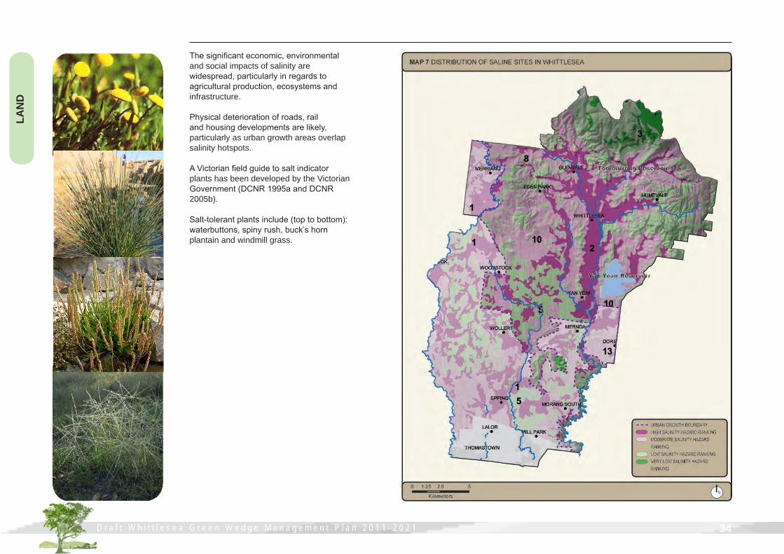
SalinityThe City of Whittlesea and the Shire of Nillumbik are one of three priority salinity management zones within the Port Phillip and Westernport CMA region.
In 2005, over 450 hectares in the Whittlesea/Nillumbik salinity management zone was affected by saline discharge (DPI 2005). Within the City of Whittlesea, over sixty saline discharge sites have been identified.
Historically, the removal of vegetation is considered to be the major cause of salinity in these areas (Thomas 1994). Refer to Map 7 over the page for an indication of saline discharge sites throughout the municipality.
This map identifies and prioritises sites for salinity management actions based on landscape salinity susceptibility and salinity hazard. Salinity hazard is defined as the likelihood that salinity will occur within the landscape (Clifton & Heislers 2004).
Within the City of Whittlesea, this includes five key sites represented numerically on Map 7:
GFS 1: Alluvial plain HPGFS 2: Main alluvial valley HPGFS 8: Steep valley heads MPGFS 10: Undulating low hills MPGFS 13: Undulating rises MP
According to the Department of Primary Industries, specific management options for the following groundwater flow systems include the following:
• GFS 1 (High Priority) It is unrealistic to eliminate salinity from these areas due to the nature of the underlying soils and high watertables. Trees and woody revegetation will assist but the impact will be slow. Learning to live with salt is the key option, as is the planting of salt tolerant pastures.
• GFS 2 and 13 (Moderate to High Priority) Revegetation of these sites with trees will reduce runoff and waterlogging. The establishment of salt tolerant pastures will also assist to stabilise and reduce waterlogging risk.
• GFS 8 and 10 (Moderate Priority) High density revegetation, particularly on the slopes, will reduce runoff and waterlogging into adjacent areas. Perennial pasture effectiveness will be limited by the moderate annual rainfall.
D r a f t W h i t t l e s e a G r e e n W e d g e M a n a g e m e n t P l a n 2 0 1 1 - 2 0 2 1 34
LAN
D
D r a f t W h i t t l e s e a G r e e n W e d g e M a n a g e m e n t P l a n 2 0 1 1 - 2 0 2 1
The significant economic, environmental and social impacts of salinity are widespread, particularly in regards to agricultural production, ecosystems and infrastructure.
Physical deterioration of roads, rail and housing developments are likely, particularly as urban growth areas overlap salinity hotspots.
A Victorian field guide to salt indicator plants has been developed by the Victorian Government (DCNR 1995a and DCNR 2005b).
Salt-tolerant plants include (top to bottom): waterbuttons, spiny rush, buck’s horn plantain and windmill grass.
D r a f t W h i t t l e s e a G r e e n W e d g e M a n a g e m e n t P l a n 2 0 1 1 - 2 0 2 1 35
LAN
D
D r a f t W h i t t l e s e a G r e e n W e d g e M a n a g e m e n t P l a n 2 0 1 1 - 2 0 2 1
ErosionThe Whittlesea Green Wedge contains areas of sheet, tunnel and gully erosion. The most severely effected areas are Eden Hills, Barbers Creek and Scrubby Creek (Beardsell 1997).
The historic removal of foothill forests and excessive grazing on the fragile soils of the Eden Hills area in particular has led to a high erosion hazard, particularly tunnel and gully erosion.
Parts of Eden Park/Humevale are identified as one of five erosion hot spots within the Yarra Catchment (Thomas and Cummings 1994).
The significant environmental and economic impacts of erosion are often site specific, yet their effects are wide ranging. This is particularly evident with regards to water quality, diminishing areas of productive agricultural land and damage to farm infrastructure such as fences.
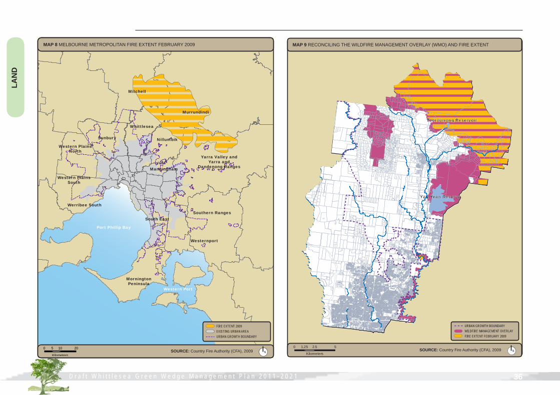
FireOn Saturday 7 February 2009, Victoria experienced a bushfire so severe it has been recognised as the worst natural disaster in Australia's history. The devastation resulted in the loss of 2029 homes, affected 78 communities and 500,000 hectares of land across Victoria. Businesses, schools, sporting clubs, homes, water catchments, cool temperate rainforests and towns were destroyed (refer to Map 8 over the page).
Within the municipality, the communities of Humevale, Whittlesea and Kinglake West, and the Mt Disappointment State Forest, Toorourrong water catchment and Kinglake National Park were severely affected. Over 76 houses were destroyed and another 100 properties suffered significant damage. Nearly 8400 hectares of land and 30 kilometres of roads were burnt. Over 20% of the Whittlesea Green Wedge, at that time, was fire affected.
Since then, there has been significant progress in site clean-up, temporary housing and rebuilding of community facilities. The Victorian Bushfire Appeal Fund, as well as the Commonwealth and Victorian Governments, has made available a range of financial assistance packages that continue to expand as communities move towards the rebuilding phase.
Council established a dedicated bushfire team comprising a range of Community Development officers, a community drop-in point in Whittlesea Township and a ‘Project Rebuild’ team comprising Council Building, Planning, Land Management and Health staff.
Residents within the Whittlesea Green Wedge are concerned about the effects of fire on weeds and erosion, wildlife and lack of vegetation, and the inability to run stock on their land due to lack of feed and shelter. Council in conjunction with Caring for our Country has employed a Land Management Recovery Officer. In partnership with landholders, rehabilitation works have occurred on 78 fire affected properties.
Field days focussing on pasture recovery, wildlife, native vegetation regeneration and whole farm planning have been well attended and weed control measures have occurred across the Whittlesea Green Wedge. The program ‘FenceAid’ has helped farmers replace kilometres of fencing throughout the Whittlesea Green Wedge.
At the request of the community, the City of Whittlesea coordinated a Bushfire Rebuilding Expo on Saturday 23 May 2009 at Whittlesea Showgrounds. Over 2500 people attended from fire affected communities across the region.
Despite the many challenges faced by our fire affected communities, a sense of determination and resilience is evident.
D r a f t W h i t t l e s e a G r e e n W e d g e M a n a g e m e n t P l a n 2 0 1 1 - 2 0 2 1 36
LAN
D
D r a f t W h i t t l e s e a G r e e n W e d g e M a n a g e m e n t P l a n 2 0 1 1 - 2 0 2 1
Werribee South
Western Plains South
Western Plains North
Sunbury
Whittlesea
Nillumbik
Manningham
Yarra Valley and Yarra and
Dandenong Ranges
Southern Ranges
Westernport
South East
Mornington Peninsula
Port Phillip Bay
Western Port
Mitchell
Murrundindi
MAP 8 MELBOURNE METROPOLITAN FIRE EXTENT FEBRUARY 2009
FIRE EXTENT 2009EXISTING URBAN AREAURBAN GROWTH BOUNDARY
N0 10 205
KilometersSOURCE: Country Fire Authority (CFA), 2009
Yan Yean Reservoir
Toorourrong Reservoir
URBAN GROWTH BOUNDARYWILDFIRE MANAGEMENT OVERLAYFIRE EXTENT FEBRUARY 2009
MAP 9 RECONCILING THE WILDFIRE MANAGEMENT OVERLAY (WMO) AND FIRE EXTENT
N0 2.5 51.25
KilometersSOURCE: Country Fire Authority (CFA), 2009