Embed Size (px)
Citation preview
Isidore of Seville #205
84
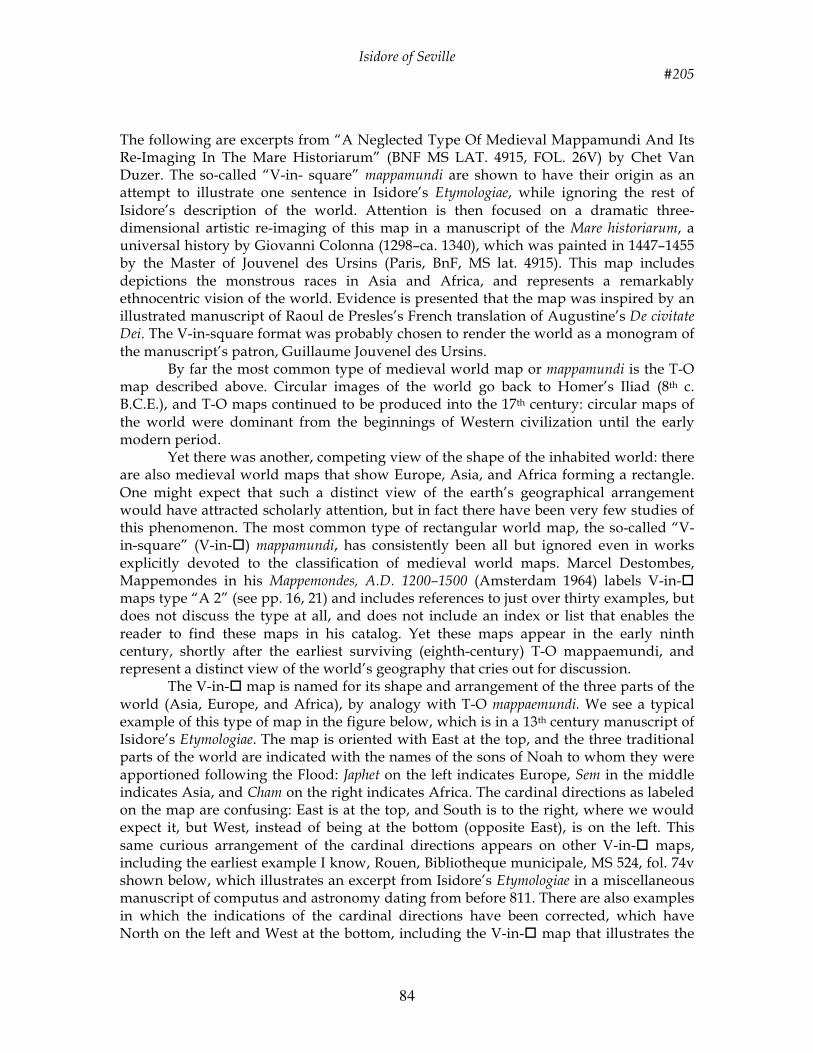
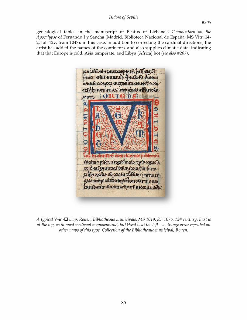
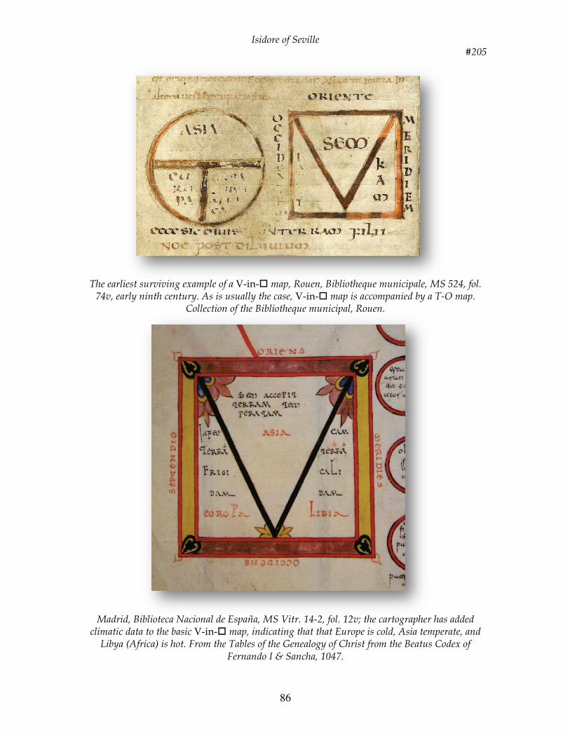
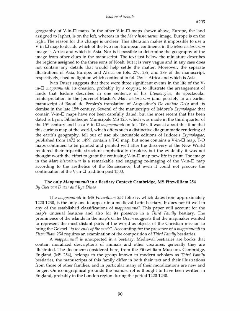
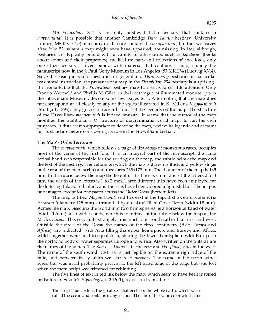
The following are excerpts from “A Neglected Type Of Medieval Mappamundi And Its Re-Imaging In The Mare Historiarum” (BNF MS LAT. 4915, FOL. 26V) by Chet Van Duzer. The so-called “V-in- square” mappamundi are shown to have their origin as an attempt to illustrate one sentence in Isidore’s Etymologiae, while ignoring the rest of Isidore’s description of the world. Attention is then focused on a dramatic three-dimensional artistic re-imaging of this map in a manuscript of the Mare historiarum, a universal history by Giovanni Colonna (1298–ca. 1340), which was painted in 1447–1455 by the Master of Jouvenel des Ursins (Paris, BnF, MS lat. 4915). This map includes depictions the monstrous races in Asia and Africa, and represents a remarkably ethnocentric vision of the world. Evidence is presented that the map was inspired by an illustrated manuscript of Raoul de Presles’s French translation of Augustine’s De civitate Dei. The V-in-square format was probably chosen to render the world as a monogram of the manuscript’s patron, Guillaume Jouvenel des Ursins. By far the most common type of medieval world map or mappamundi is the T-O map described above. Circular images of the world go back to Homer’s Iliad (8th c. B.C.E.), and T-O maps continued to be produced into the 17th century: circular maps of the world were dominant from the beginnings of Western civilization until the early modern period. Yet there was another, competing view of the shape of the inhabited world: there are also medieval world maps that show Europe, Asia, and Africa forming a rectangle. One might expect that such a distinct view of the earth’s geographical arrangement would have attracted scholarly attention, but in fact there have been very few studies of this phenomenon. The most common type of rectangular world map, the so-called “V-in-square” (V-in-) mappamundi, has consistently been all but ignored even in works explicitly devoted to the classification of medieval world maps. Marcel Destombes, Mappemondes in his Mappemondes, A.D. 1200–1500 (Amsterdam 1964) labels V-in- maps type “A 2” (see pp. 16, 21) and includes references to just over thirty examples, but does not discuss the type at all, and does not include an index or list that enables the reader to find these maps in his catalog. Yet these maps appear in the early ninth century, shortly after the earliest surviving (eighth-century) T-O mappaemundi, and represent a distinct view of the world’s geography that cries out for discussion. The V-in- map is named for its shape and arrangement of the three parts of the world (Asia, Europe, and Africa), by analogy with T-O mappaemundi. We see a typical example of this type of map in the figure below, which is in a 13th century manuscript of Isidore’s Etymologiae. The map is oriented with East at the top, and the three traditional parts of the world are indicated with the names of the sons of Noah to whom they were apportioned following the Flood: Japhet on the left indicates Europe, Sem in the middle indicates Asia, and Cham on the right indicates Africa. The cardinal directions as labeled on the map are confusing: East is at the top, and South is to the right, where we would expect it, but West, instead of being at the bottom (opposite East), is on the left. This same curious arrangement of the cardinal directions appears on other V-in- maps, including the earliest example I know, Rouen, Bibliotheque municipale, MS 524, fol. 74v shown below, which illustrates an excerpt from Isidore’s Etymologiae in a miscellaneous manuscript of computus and astronomy dating from before 811. There are also examples in which the indications of the cardinal directions have been corrected, which have North on the left and West at the bottom, including the V-in- map that illustrates the
Isidore of Seville #205
85
genealogical tables in the manuscript of Beatus of Liébana’s Commentary on the Apocalypse of Fernando I y Sancha (Madrid, Biblioteca Nacional de España, MS Vitr. 14-2, fol. 12v, from 1047): in this case, in addition to correcting the cardinal directions, the artist has added the names of the continents, and also supplies climatic data, indicating that that Europe is cold, Asia temperate, and Libya (Africa) hot (see also #207).
A typical V-in- map, Rouen, Bibliotheque municipale, MS 1019, fol. 107v, 13th century. East is at the top, as in most medieval mappaemundi, but West is at the left—a strange error repeated on
other maps of this type. Collection of the Bibliotheque municipal, Rouen.
A NEGLECTED TYPE OF MEDIEVAL MAPPAMUNDI
293
FIG. 2. A typical V-in-Ƒ map, Rouen, Bibliothèque municipale, MS 1019, fol. 107v, thirteenth century. East is at the top, as in most medieval mappaemundi, but West is at the left—a strange error repeated on other maps of this type. Collection of the Biblio-thèque municipal, Rouen. Photograph: Thierry Ascencio-Parvy.
Isidore of Seville #205
86
The earliest surviving example of a V-in- map, Rouen, Bibliotheque municipale, MS 524, fol.
74v, early ninth century. As is usually the case, V-in- map is accompanied by a T-O map. Collection of the Bibliotheque municipal, Rouen.
Madrid, Biblioteca Nacional de España, MS Vitr. 14-2, fol. 12v; the cartographer has added
climatic data to the basic V-in- map, indicating that that Europe is cold, Asia temperate, and Libya (Africa) is hot. From the Tables of the Genealogy of Christ from the Beatus Codex of
Fernando I & Sancha, 1047.
CHET VAN DUZER
294
FIG. 3. The earliest surviving example of a V-in-Ƒ map, Rouen, Bibliothèque munici-pale, MS 524, fol. 74v, early ninth century. As is usually the case, V-in-Ƒ map is ac-companied by a T-O map. Collection of the Bibliothèque municipal, Rouen. Photo-graph: Thierry Ascencio-Parvy.
A NEGLECTED TYPE OF MEDIEVAL MAPPAMUNDI
295
FIG. 4. Madrid, Biblioteca Nacional de España, MS Vitr. 14-2, fol. 12v, from 1047;
the cartographer has added climatic data to the basic V-in-Ƒ map, indicating that that
Europe is cold, Asia temperate, and Libya (Africa) is hot. By permission of the Bib-
lioteca Nacional de España.
Isidore of Seville #205
87
This curious vision of the world’s geography originated in a manuscript of Isidore of Seville’s great encyclopedia the Etymologiae, which was written in the latter part of his life (he died in 636). We can be sure that the V-in- map first appeared in a manuscript of the Etymologiae for three reasons: first, as mentioned above, the earliest surviving example of the map appears in that context; second, of the thirty-five surviving examples of V-in- maps, the vast majority (thirty-one) illustrate manuscripts of this work; and third, the map is well suited to its context in the Etymologiae, albeit in a peculiar way. The maps appear at the opening of Book 14, with the text De terra et partibus [Of the earth and its parts]. The V-in- map is almost always accompanied by a T-O map, and there is a certain logic to this arrangement, as V-in- maps do not accord well with Isidore’s general account of the world’s geography, while T-O maps do. V-in- maps are rectangular, but Isidore says in the clearest possible terms that the ecumene or inhabited part of the world is round like a wheel (14.2.1):
The disk [of the lands] derives its name from the roundness of the circle, because it resembles a wheel; hence a small wheel is called a “small disk.” Indeed, the Ocean that flows around it on all sides encompasses its furthest reaches in a circle.
Moreover, after he says that the world is divided into Asia, Europe, and Africa, Isidore continues (14.2.3): “Whence it is clear that two of them, Europe and Africa, occupy half of the circle of lands, while Asia occupies the other half by itself”. This sentence applies with perfect clarity to a T-O map, but not to a V-in- map, where there are no halves. In addition, Isidore (14.2.3) talks of the Mediterranean separating Africa and Europe, but the V-in- maps show no body of water separating these two continents; instead, the continents meet at a point at the western edge of the world (the bottom of the map). But while the V-in- map agrees very poorly indeed with Isidore’s overall description of the world, it does agree with one sentence of his description. Isidore writes (14.2.2):
For Asia extends from south to north in the east, but Europe from the north to the west, Africa from the west to the south.
The V-in- map is a graphic interpretation of just this sentence, a diagram to show the relative positions of the parts of the world as Isidore describes them here, without taking into account his other pronouncements about the world’s geography (though it is not clear why this extra diagram was thought necessary, as the T-O maps that also generally accompany this passage seem to illustrate this sentence perfectly well). The placement of the cardinal directions on the “corrected” versions of the V-in- mappamundi accords perfectly with Isidore’s description in this sentence. As it happens, the V-in- maps also accord with Isidore’s declaration in the following sentence (14.2.3) that Asia is equal in size to Europe and Africa together, but as he is speaking of the orbem or disk of lands in that sentence, this was perhaps just a fortunate coincidence for the maker of the V-in- map—of course the T-O map also illustrates the size equivalence of Asia to Europe and Africa together, and does so much more clearly than the V-in- map. The very interesting question of whether Isidore included a T-O map in the auto- graph manuscripts of his Etymologiae and De natura rerum it is still disputed; I am inclined to believe that he did include a T-O map in the Etymologiae, as his description of the world reads as if keyed to a diagram, and it agrees in every detail with a T- O map. The matter is different, however, with the V-in- map. Although the map does agree with one sentence of Isidore’s description of the world, it does not elucidate that sentence at all, and as shown above, it disagrees quite blatantly with the rest of his
Isidore of Seville #205
88
description. It is impossible to escape the strangeness of the map. Another aspect of the V-in- map that bears on this question is the fact that on most of them, including the earliest surviving example, the parts of the world are labeled not with their names (Europa, Africa, and Asia), but rather with the names of Noah’s sons who took possession of them. The use of the names of Noah’s sons represents another disconnect between the map and its manuscript context, for although Isidore alludes to Noah’s division of the world among his sons in Etymologiae 9.2.2, he never describes the division, neither at the beginning of Book 14 nor anywhere in the Etymologiae. In fact in 14.2.1-3 he uses the names of the continents repeatedly, and does not mention Noah’s sons. There are many cases in which the names of Noah’s sons are added to medieval mappaemundi even though they do not appear in the manuscript passage that the maps illustrate, but nonetheless the use of these names is another factor that distances the V-in- from its context. Thus it seems very likely that the map was added to an early manuscript of the Etymologiae by a copyist, rather than having originated with Isidore himself. While V-in- map that illustrates Isidore’s description of the world is in all likelihood post-Isidorean, Isidore himself borrowed most of his description of the world from an earlier source, namely Augustine’s De civitate Dei, written in the first quarter of the fifth century, about 200 years before Isidore composed his Etymologiae. The first two sentences of Isidore’s description (14.2.1), about the lands being circular and surrounded by the circular ocean, are not borrowed from Augustine, but the rest—in which he discusses the division of the lands into the three continents, their sizes and locations, and the fact that Asia forms one half of the world and Europe and Africa the other—is paraphrased very closely from De civitate Dei 16.17.21 There is no evidence that this passage in Augustine was ever illustrated with a mappamundi, much less a V-in- map, but we will see that by a remarkable coincidence, Augustine’s De civitate Dei, which was the source of much of Isidore’s description of the world that inspired the V-in- map, played an important role in inspiring a spectacular reinterpretation of the map near the end of the map’s career, and so the history of this map will come full circle. The V-in- map continued to be copied in some manuscripts of Isidore’s Etymologiae into the 15th century, and around the middle of that century a gifted Renaissance artist produced the remarkable reinterpretation of the map alluded to above. This reinterpretation appears in a manuscript of the Mare historiarum, a universal history which is the most important work of the Dominican chronicler Giovanni Colonna (1298–ca. 1340). This history begins from the Creation, and the author intended to bring it down to his own lifetime, but he was unable to complete the book, and it ends abruptly in 1250. Colonna’s most important source by far was Vincent of Beauvais, and he also made use of Lactantius, Livy, Josephus, and St. Jerome. The work survives in seven manuscripts, only one of which is illustrated, namely Paris, BnF, MS lat. 4915,25 which was painted in 1447–1455 by the so-called Master of Jouvenel des Ursins (Maitre de Jouvenel des Ursins) and his colleagues for Chancellor Guillaume Jouvenel des Ursins (1400–1472). The program of illustration in this manuscript is very ambitious, with a total of 730 miniatures; unfortunately there has not been a general study of the artists’ iconographical sources. One of the Jouvenel Master’s illustrations is of particular interest from the cultural, artistic, and cartographic points of view. On fol. 26v (shown below) he illustrates the re-peopling of the world following Noah’s Flood, when Noah divided the earth among his three sons, giving Europe to Japhet, Asia to Sem, and Africa to Cham.
Isidore of Seville #205
89
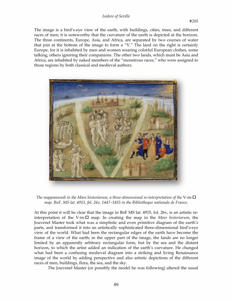
The image is a bird’s-eye view of the earth, with buildings, cities, trees, and different races of men; it is noteworthy that the curvature of the earth is depicted at the horizon. The three continents, Europe, Asia, and Africa, are separated by two courses of water that join at the bottom of the image to form a “V.” The land on the right is certainly Europe, for it is inhabited by men and women wearing colorful European clothes, some talking, others ignoring their companions. The other two lands, which must be Asia and Africa, are inhabited by naked members of the “monstrous races,” who were assigned to those regions by both classical and medieval authors.
The mappamundi in the Mare historiarum, a three-dimensional re-interpretation of the V-in-
map. BnF, MS lat. 4915, fol. 26v, 1447–1455 in the Bibliotheque nationale de France.
At this point it will be clear that the image in BnF MS lat. 4915, fol. 26v, is an artistic re-interpretation of the V-in- map. In creating the map in the Mare historiarum, the Jouvenel Master took what was a simplistic and even primitive diagram of the earth’s parts, and transformed it into an artistically sophisticated three-dimensional bird’s-eye view of the world. What had been the rectangular edges of the earth have become the frame of a view of the earth; in the upper part of the image, the lands are no longer limited by an apparently arbitrary rectangular form, but by the sea and the distant horizon, to which the artist added an indication of the earth’s curvature. He changed what had been a confusing medieval diagram into a striking and living Renaissance image of the world by adding perspective and also artistic depictions of the different races of men, buildings, flora, the sea, and the sky. The Jouvenel Master (or possibly the model he was following) altered the usual
CHET VAN DUZER
296
FIG. 5. The mappamundi in the Mare historiarum, a three-dimensional re-interpreta-tion of the V-in-Ƒ map. BnF, MS lat. 4915, fol. 26v, 1447–1455. By permission of the Bibliothèque nationale de France.
Isidore of Seville #205
90
geography of V-in- maps. In the other V-in- maps shown above, Europe, the land assigned to Japhet, is on the left, whereas in the Mare historiarum image, Europe is on the right. The reason for this change is unclear. This alteration makes it impossible to use a V-in- map to decide which of the two non-European continents in the Mare historiarum image is Africa and which is Asia. Nor is it possible to determine the geography of the image from other clues in the manuscript. The text just below the miniature describes the regions assigned to the three sons of Noah, but it is very vague and in any case does not contain any details that would help settle the matter. Moreover, the separate illustrations of Asia, Europe, and Africa on fols. 27v, 28r, and 28v of the manuscript, respectively, shed no light on which continent in fol. 26v is Africa and which is Asia. Ivan Duzer suggests that there were three significant events in the life of the V-in- mappamundi: its creation, probably by a copyist, to illustrate the arrangement of lands that Isidore describes in one sentence of his Etymologiae; its spectacular reinterpretation in the Jouvenel Master’s Mare historiarum (and possibly in an earlier manuscript of Raoul de Presles’s translation of Augustine’s De civitate Dei); and its demise in the late 15th century. Several of the manuscripts of Isidore’s Etymologiae that contain V-in- maps have not been carefully dated, but the most recent that has been dated is Lyon, Bibliotheque Municipale MS 125, which was made in the third quarter of the 15th century and has a V-in- mappamundi on fol. 106r. It was at about this time that this curious map of the world, which offers such a distinctive diagrammatic rendering of the earth’s geography, fell out of use: six incunable editions of Isidore’s Etymologiae, published from 1472 to 1499, contain a T-O map, but none contains a V-in- map. T-O maps continued to be painted and printed well after the discovery of the New World rendered their tripartite structure emphatically obsolete, but the evidently it was not thought worth the effort to grant the confusing V-in- map new life in print. The image in the Mare historiarum is a remarkable and engaging re-imaging of the V-in- map according to the aesthetics of the Renaissance, but even it could not procure the continuation of the V-in- tradition past 1500.
The only Mappamundi in a Bestiary Context: Cambridge, MS Fitzwilliam 254 By Chet van Duzer and Ilya Dines
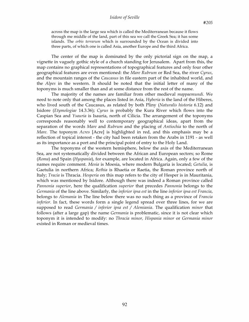
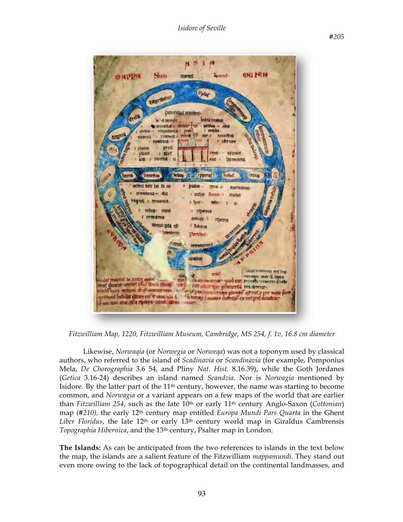
The mappamundi in MS Fitzwilliam 254 folio iv, which dates from approximately 1220-1230, is the only one to appear in a medieval Latin bestiary. It does not fit well in any of the established classifications of mappaemundi. This paper will account for the map's unusual features and also for its presence in a Third Family bestiary. The prominence of the islands in the map's Outer Ocean suggests that the mapmaker wanted to represent the most distant parts of the world as objects of the Christian mission to bring the Gospel “to the ends of the earth”. Accounting for the presence of a mappamundi in Fitzwilliam 254 requires an examination of the composition of Third Family bestiaries.
A mappamundi is unexpected in a bestiary. Medieval bestiaries are books that contain moralized descriptions of animals and other creatures; generally they are illustrated. The document considered here, from the Fitzwilliam Museum, Cambridge, England (MS 254), belongs to the group known to modern scholars as Third Family bestiaries; the manuscripts of this family differ in both their text and their illustrations from those of other families, and in particular many of their moralizations are new and longer. On iconographical grounds the manuscript is thought to have been written in England, probably in the London region during the period 1220-1230.
Isidore of Seville #205
91
MS Fitzwilliam 254 is the only medieval Latin bestiary that contains a mappamundi. It is possible that another Cambridge Third Family bestiary (University Library, MS KK. 4.25) of a similar date once contained a mappamundi, but the two leaves after folio 52, where a map might once have appeared, are missing. In fact, although, bestiaries are typically bound with a variety of other texts, such as lapidaries (books about stones and their properties), medical tractates and collections of anecdotes, only one other bestiary is even bound with material that contains a map, namely the manuscript now in the J. Paul Getty Museum in Los Angeles (83.MR.174 (Ludwig XV.4). Since the basic purpose of bestiaries in general and Third Family bestiaries in particular was moral instruction, the presence of a map in the Fitzwilliam 254 bestiary is surprising. It is remarkable that the Fitzwilliam bestiary map has received so little attention. Only Francis Wormald and Phyllis M. Giles, in their catalogue of illuminated manuscripts in the Fitzwilliam Museum, devote some few pages to it. After noting that the map does not correspond at all closely to any of the styles illustrated in K. Miller’s Mappaemundi (Stuttgart, 1895), they go on to transcribe most of the legends on the map. The structure of the Fitzwilliam mappamundi is indeed unusual. It seems that the author of the map modified the traditional T-O structure of diagrammatic world maps to suit his own purposes. It thus seems appropriate to describe the map, review its legends and account for its structure before considering its role in the Fitzwilliam bestiary. The Map’s Orbis Terrarum
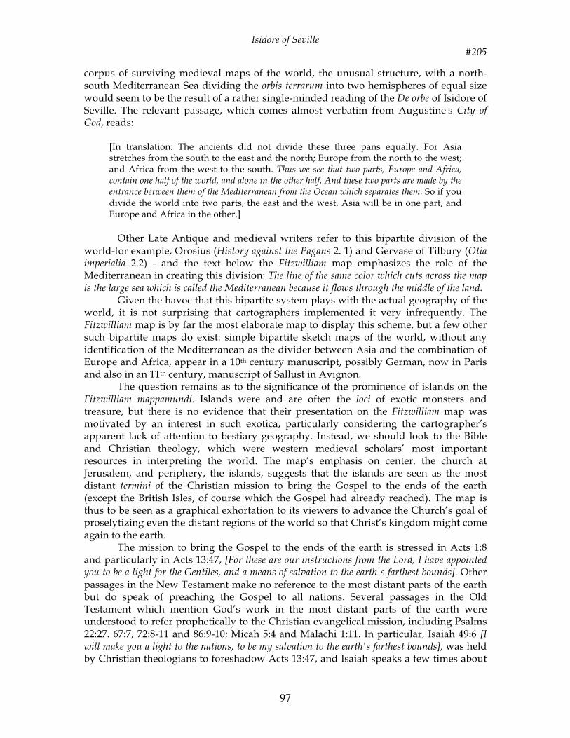
The mappamundi, which follows a page of drawings of monstrous races, occupies most of the verso of the first folio. It is an integral part of the manuscript; the same scribal hand was responsible for the writing on the map, the rubric below the map and the text of the bestiary. The vellum on which the map is drawn is thick and yellowish (as in the rest of the manuscript) and measures 263x178 mm. The diameter of the map is 165 mm. In the rubric below the map the height of the lines is 6 mm and of the letters 2 to 3 mm; the width of the letters is 1 to 2 mm. Three different inks have been employed for the lettering (black, red, blue), and the seas have been colored a lightish blue. The map is undamaged except for one patch across the Outer Ocean (bottom left).
The map is titled Mappa Mondi and has east at the top. It shows a circular orbis terrarum (diameter 129 mm) surrounded by an island-filled Outer Ocean (width 18 mm). Across file map, bisecting the world into two hemispheres, is a horizontal band of water (width 12mm), also with islands, which is identified in the rubric below the map as the Mediterranean. This sea, quite strangely runs north and south rather than cast and west. Outside the circle of the Ocean the names of the three continents (Asia, Evropa and Affrica), are indicated, with Asia filling the upper hemisphere and Europe and Africa, which together were held to equal Asia, sharing the lower hemisphere with Europe to the north: no body of water separates Europe and Africa. Also written on the outside are the names of the winds. The Subso ... Lanus is in the east and the [Favo] nius in the west. The name of the south wind, aust...er, is just legible on the extreme right edge of the folio, and between its syllables we also read meridies. The name of the north wind, Septentrio, was in all probability present at the left-hand edge of the page but was lost when the manuscript was trimmed for rebinding.
The five lines of text in red ink below the map, which seem to have been inspired by Isidore of Seville’s Etymologiae (13.16. 1), reads – in translation:
The large blue circle is the great sea that encloses the whole earth, which sea is called the ocean and contains many islands. The line of the same color which cuts
Isidore of Seville #205
92
across the map is the large sea which is called the Mediterranean because it flows through me middle of the land, part of this sea we call the Greek Sea; it has some islands. The orbis terrarum which is surrounded by the Ocean is divided into three parts, of which one is called Asia, another Europe and the third Africa. The center of the map is dominated by the only pictorial sign on the map, a
vignette in vaguely gothic style of a church standing for Jerusalem. Apart from this, the map contains no graphical representations of topographical features and only four other geographical features are even mentioned: the Mare Rubrum or Red Sea, the river Cyrus, and the mountain ranges of the Caucasus in file eastern part of the inhabited world, and the Alpes in the western. It should be noted that the initial letter of many of the toponyms is much smaller than and at some distance from the rest of the name. The majority of the names are familiar from other medieval mappaemundi. We need to note only that among the places listed in Asia, Hyberia is the land of the Hiberes, who lived south of the Caucasus, as related by both Pliny (Naturalis historia 6.12) and Isidore (Etymologiae 14.3.36); Cyrus is probably the Kura River which flows into the Caspian Sea and Ysauria is Isauria, north of Cilicia. The arrangement of the toponyms corresponds reasonably well to contemporary geographical ideas, apart from the separation of the words Mare and Rubrum and the placing of Antiochia to the north of Mare. The toponym Acres [Acre] is highlighted in red, and this emphasis may be a reflection of topical interest - the city had been retaken from the Arabs in 1191 - as well as its importance as a port and the principal point of entry to the Holy Land.
The toponyms of the western hemisphere, below the axis of the Mediterranean Sea, are not systematically divided between the African and European sectors; so Rome (Roma) and Spain (Hyspania), for example, are located in Africa. Again, only a few of the names require comment. Mesia is Moesia, where modern Bulgaria is located; Getulia, is Gaetulia in northern Africa; Rethia is Rhaetia or Raetia, the Roman province north of Italy; Tracia is Thracia. Hesperia on this map refers to the city of Hesper is in Mauritania, which was mentioned by Isidore. Although there was indeed a Roman province called Pannonia superior, here the qualification superior that precedes Pannonia belongs to the Germania of the line above. Similarly, the inferior ipsa est in the line inferior ipsa est Francia, belongs to Alemania in The line below there was no such thing as a province of Francia inferior. In fact, these words form a single legend spread over three lines, for we are supposed to read Germania / inferior ipsa est / Alemiania. The qualification minor that follows (after a large gap) the name Germania is problematic, since it is not clear which toponym it is intended to modify: no Thracia minor, Hispania minor or Germania minor existed in Roman or medieval times.
Isidore of Seville #205
93
Fitzwilliam Map, 1220, Fitzwilliam Museum, Cambridge, MS 254, f. 1v, 16.8 cm diameter
Likewise, Norwaqia (or Norwegia or Norweqa) was not a toponym used by classical
authors, who referred to the island of Scadinavia or Scandinavia (for example, Pomponius Mela, De Chorographia 3.6 54, and Pliny Nat. Hist. 8.16.39), while the Goth Jordanes (Getica 3.16-24) describes an island named Scandzia. Nor is Norwagia mentioned by Isidore. By the latter part of the 11th century, however, the name was starting to become common, and Norwagia or a variant appears on a few maps of the world that are earlier than Fitzwilliam 254, such as the late 10th or early 11th century Anglo-Saxon (Cottonian) map (#210), the early 12th century map entitled Europa Mundi Pars Quarta in the Ghent Liber Floridus, the late 12th or early 13th century world map in Giraldus Cambrensis Topographia Hibernica, and the 13th century, Psalter map in London. The Islands: As can be anticipated from the two references to islands in the text below the map, the islands are a salient feature of the Fitzwilliam mappamundi. They stand out even more owing to the lack of topographical detail on the continental landmasses, and
Isidore of Seville #205
94
they merit attention. They fall into two groups - those within the Mediterranean Sea and those in the Ocean that surrounds the world - with each island named. As the text reminds us, the Mediterranean was also called the Greek Sea, so it is not surprising that the six Mediterranean islands are all from the southern Aegean: Sitera, Tenedos, Delos, Cyprus, Rodos and Creta. Sitera, in the north is Cytherea or Citarea, the westernmost of the Cyclades (Isidore, Etym. 14.6.25), Although Isidore mentioned that Tenedos is the northernmost of tile Cyclades (14.6.23), Tenedos has not been placed at the end (that is, the northern extremity), of the Mediterranean Sea as represented on the Fitzwilliam mappamundi.
The second group of islands is located in the Outer Ocean. A few are in their correct geographical locations, but the impression gained is that the creator of the map was unconcerned about the finer points of geographical accuracy. It is worth looking at each island, however, in case light may be shed on any particular interest it may have had for the compiler of the map. There are sixteen islands altogether; reading clockwise from the top of the map, the first is Tylos. This is not the northern island of Thule (which is absent from the map), but an island in the Indian Ocean that was well known to the ancients. After TyIos comes a much larger island labeled Bragmannorum insule [Island of the Bragmanni], which is curious since these mythical people were not usually associated with islands in either Classical or medieval times. According to early writers, the Bragmanni (or Bracmani or Bragmani) were wise men living in India with whom Alexander the Great had an extended philosophical debate. The episode attracted considerable interest among medieval moralists and references to the Bragmanni abound. Indeed the Bragmanni –‘Gens quidam Bragmannorum’-[a certain race of the Bragmanni] are one of the fabulous or monstrous races pictured on the verso of the map, together with a Sciopos [sciapod] and ‘Pigmeus’ [pygmy] and they are discussed early in the text of the bestiary (fol. 2v). They are mentioned in Palladius’ De Gentibus Indiae et Bragmanibus (based on material dating from the fifth century, or earlier), and in an anonymous 11th century treatise sometimes erroneously attributed to Saint Ambrose called De moribus Brachmanorum, but nothing is said about an island in either text. They are placed on an island, however, in the Alexander Romance by pseudo-Callisthenes, and also in the Suda, an encyclopedia compiled at the end of the 10th century, under the name ‘Brachman’. It is unlikely, though, that either of those works was used by the compiler of the Fitzwilliam mappamundi. The most probable direct source was John of Salisbury’s Policraticus sive de nugis curialium et vestigiis philosophorum, since all Third Family bestiaries take considerable extracts on animals and birds from this work. Next to the island of the Bragmanni is a large island labeled the Fortunatorum insule [the Isle of the Blessed]. Again, we are surprised for a southeastern location for the Fortunate Isles is unusual. Ancient and early medieval authorities consistently placed these islands in the west (Mela, Chorog. 3. 10, Pliny, Nat. Hist.6.202, Solinus, Collectanea 23.10, and Isidore, Etym. 14.6.8). After this comes the tiny island of Gor, opposite the southern end of the Mediterranean Sea, followed by the Gorgodes insule. Gor is no doubt a duplication of the Gorgodes, intended to indicate the islands’ plurality. These islands are mentioned by Isidore (Etym. 14.6.9), and the description of the Gorgons (mythical women with serpents for hair), in the text of the bestiary (fol. 44v) relies on Isidore (Etym. 11.3.29). Then come the British Isles, curiously located in the southwest of the map opposite the name of the continent of Africa. A marginal note in blue ink beyond the name Affrica and just above the text below the map describes the British Isles: Insula
Isidore of Seville #205
95
brittannie tres regiones capit, id est Walliam, angliam et scotiam que et albania dicitur [The British Isles are composed of three regions, that is, Wales, England and Scotland, which is also called Albion]. The two islands lie side by side. The westernmost island is labeled hybernia, the easternmost has the names Wallia. Anglia and, on the other side of a line, presumably representing Hadrian's Wall, Scotia. The proximity of the marginal note to the image can be seen as emphasizing the importance of these islands to the English artist.
In contrast to the fairly obvious importance of the British Isles to the compiler of the map, one may wonder what reasoning underlies the remarkable prominence of the Orcades (Orkneys) represented by three islands which are correctly located to the north of the British Isles. The Orcades were the farthest point in northwest Europe reached by the Romans when Agricola's fleet conquered the islands during his governorship of Britain (AD 78-84), but no textual source accords them any particular iconic status. It is possible that the compiler of the Fitzwilliam map, or the map he was using as a source, had been influenced by Macrobian mappaemundi (#201). Many of the world maps in extant manuscripts of Macrobius’ Commentarii in Somnium Scipionis (Commentary on the Dream of Scipio, composed in the fifth century), include and label the Orcades even when few other toponyms are supplied, and (in at least one example the Horcades insule are drawn and named twice. The southernmost island, just beyond Scotland, is clearly labeled Orcadia; damage to the map has obliterated half of the middle island, but it seems to have been labeled simply Or (compare the Gor/Gorgodes duplication mentioned above). The northernmost of the three Orcades is the largest and carries the longest single legend on the map: Orcadia in xxxiii insulas dividitur, quamxx deserte sunt et xiii coluntur [The Orcades are divided into thirty-three islands of which twenty are deserted and thirteen are cultivated]. This text has come almost verbatim from either Orosius’ Historia adversa paganos [History against the Pagans] (1.2.78) or Isidore’s Etymnologiae (14.6.5), and confirms the compiler's use of one of these authors rather than, for example, Pliny (Nat Hist. 4.103) or Martianus Capella (De nuptiis Philologiae et Mercurii 4.666) - for both said that the Orcades contain forty islands - or Solinus (Collectanea 22.16), who said that there were three.
After the Orcades come, three islands whose names all begin with G. In fact, The first is labeled simply G, no doubt as an abbreviation for Gades, the name given in full on the next island, which is correctly placed at the end of the Mediterranean although, given the way the Mediterranean has been made to run north-south, it appears in the extreme north of the inhabited world instead of the extreme west. The third island is labeled GIG. This could be yet another contraction for Gades, as Wormald and Giles thought, or it could be argued that GIG is a scribal error for CIC, standing for columna/columna, and that it was intended to indicate the Columns of Hercules, which according to Classical tradition guarded the entrance to the Atlantic Ocean opposite Gades, and which some authorities said were located on an island or islands. Opinions differed as to the number of islands involved. Isidore placed the Columns on one island called Gades, while Hugh of Saint Victor, writing in about 1130-1135 (Descritio Mappe Mundi, lines 106-9), placed them on three islands named Gades.
The remaining three islands in the Outer Ocean complete the circuit. Argiria and Crisa - the first rich in silver and the second in gold - are mentioned by authorities such as Pomponius Mela, Pliny, Solinus and Isidore; Taprabana, which is located on the map reasonably close to its correct position, is also mentioned by Mela, Pliny, Solinus and Isidore. The sequence Argiria, Crisa, Taprabana and Tilos is similar to Isidore’s (except
Isidore of Seville #205
96
that Isidore places Chryse before Arqyre). This order increases the likelihood that the mapmaker relied on Isidore (or a source who used Isidore) in designing this part of the map. The line drawn across the Ocean between Crisa and Taprabana is puzzling. It may be no more than a reference point made by the artist to assist him to set out the parts of the map on the page. Isidore mentions that Taprobana is at the beginning of the Indian Ocean, but if the line were intended to mark that boundary, Crisa and Argiria are on the wrong side of the line, as Isidore explicitly places them in the Indian Ocean. Contextualizing the Map: Inasmuch as the Fitzwilliam mappamundi depicts two hemispheres separated by water and places considerable emphasis on the Orcades, it might be suggested that its structure was influenced by a zonal or Macrobian map. Zonal maps are oriented to the north, however, not to the east. Nor does the map conform to a typical T-O map. On T-O maps the crossbar of the T, the body of water that separates Asia from Europe and Africa, is composed of the Tanais (Don) and Nile river, while the stem of the T, the body of water separating Europe and Africa and reaching down to the west to join the encircling ocean is the Mediterranean. But on Fitzwilliam 254, the ‘cross- bar’ water is explicitly named the Mediterranean in the rubric below the map and is filled with Mediterranean islands. No body of water separates Europe from Africa. A blank space in the middle of the map's western portion lies approximately where the Mediterranean would normally be located, but this cannot be taken as an indication that the map is incomplete. Were this space to be filled with the Mediterranean, several European toponyms (including Roma, Alpes, Hyspania, Parisius and Britannia) would be thrust into Africa, and the erroneous location of Gades in the far north would be even more glaring than it already is. Furthermore, even were the Fitzwilliam map to show the Mediterranean in the expected location between Europe and Africa, the map would still differ markedly from the majority of T-O maps. In most T-O maps the encircling Ocean is narrow and has either no or very few islands, whereas in the Fitzwilliam map the ocean is wide and is filled with large islands. It is instructive to compare the Fitzwilliam map with the rare example of a T-O map in a 12th century copy of Isidore’s Etymoloqiae now in Aix-en-Provence. This map does call to mind the Fitzwilliam map with its abundant toponyms (except in Africa), wide Mediterranean and Outer Ocean, but not a single island is found on it. It is true that islands abound on the world maps in copies of Beatus of Liebana’s eighth century Commentary on the Apocalypse (#207), but these maps display much more geographical detail than does the Fitzwilliam 254 map. In addition, one of the defining characteristics of the Beatus maps is the presence of a fourth continent in the southern hemisphere, the land of the Antipodes (see Isidore Etym. 14.5.17), which is absent from the Fitzwilliam map.
So it is difficult to find any parallel for the Fitzwilliam image. Only in the surviving part of the 11th or 12th century Saint-Omer mappamundi (#217) and in the text beneath that map, do we find something approaching the same emphasis on the islands of the world. No islands are in the vertical Mediterranean Sea nor in the transverse Don-Nile axis, but Tyle (the northern island Thule, in this case), Anglia and Hibernia are shown in the broad band of the Outer Ocean, and Taprobane and Scandza (Scandinavia) are mentioned in the text and may have been shown on the missing part. Another point in common with the Fitzwilliam map is that a large vignette of a church representing Jerusalem has been placed at or near what would have been the center of the map.
While it is difficult to find any close parallels for the Fitzwilliam map in the
Isidore of Seville #205
97
corpus of surviving medieval maps of the world, the unusual structure, with a north-south Mediterranean Sea dividing the orbis terrarum into two hemispheres of equal size would seem to be the result of a rather single-minded reading of the De orbe of Isidore of Seville. The relevant passage, which comes almost verbatim from Augustine's City of God, reads:
[In translation: The ancients did not divide these three pans equally. For Asia stretches from the south to the east and the north; Europe from the north to the west; and Africa from the west to the south. Thus we see that two parts, Europe and Africa, contain one half of the world, and alone in the other half. And these two parts are made by the entrance between them of the Mediterranean from the Ocean which separates them. So if you divide the world into two parts, the east and the west, Asia will be in one part, and Europe and Africa in the other.]
Other Late Antique and medieval writers refer to this bipartite division of the
world-for example, Orosius (History against the Pagans 2. 1) and Gervase of Tilbury (Otia imperialia 2.2) - and the text below the Fitzwilliam map emphasizes the role of the Mediterranean in creating this division: The line of the same color which cuts across the map is the large sea which is called the Mediterranean because it flows through the middle of the land.
Given the havoc that this bipartite system plays with the actual geography of the world, it is not surprising that cartographers implemented it very infrequently. The Fitzwilliam map is by far the most elaborate map to display this scheme, but a few other such bipartite maps do exist: simple bipartite sketch maps of the world, without any identification of the Mediterranean as the divider between Asia and the combination of Europe and Africa, appear in a 10th century manuscript, possibly German, now in Paris and also in an 11th century, manuscript of Sallust in Avignon.
The question remains as to the significance of the prominence of islands on the Fitzwilliam mappamundi. Islands were and are often the loci of exotic monsters and treasure, but there is no evidence that their presentation on the Fitzwilliam map was motivated by an interest in such exotica, particularly considering the cartographer’s apparent lack of attention to bestiary geography. Instead, we should look to the Bible and Christian theology, which were western medieval scholars’ most important resources in interpreting the world. The map’s emphasis on center, the church at Jerusalem, and periphery, the islands, suggests that the islands are seen as the most distant termini of the Christian mission to bring the Gospel to the ends of the earth (except the British Isles, of course which the Gospel had already reached). The map is thus to be seen as a graphical exhortation to its viewers to advance the Church’s goal of proselytizing even the distant regions of the world so that Christ’s kingdom might come again to the earth.
The mission to bring the Gospel to the ends of the earth is stressed in Acts 1:8 and particularly in Acts 13:47, [For these are our instructions from the Lord, I have appointed you to be a light for the Gentiles, and a means of salvation to the earth's farthest bounds]. Other passages in the New Testament make no reference to the most distant parts of the earth but do speak of preaching the Gospel to all nations. Several passages in the Old Testament which mention God’s work in the most distant parts of the earth were understood to refer prophetically to the Christian evangelical mission, including Psalms 22:27. 67:7, 72:8-11 and 86:9-10; Micah 5:4 and Malachi 1:11. In particular, Isaiah 49:6 [I will make you a light to the nations, to be my salvation to the earth's farthest bounds], was held by Christian theologians to foreshadow Acts 13:47, and Isaiah speaks a few times about
Isidore of Seville #205
98
the islands at the ends of the earth recognizing God's power (41:1, 41:5, 42:10 and 49:1). The most importance evidence linking world maps with the global Christian mission is supplied by the manuscripts of Beatus of Liebana’s Commentary on the Apocalypse which include mappamundi. These maps are explicitly used in the manuscripts to illustrate the sortes apostolorum, the apostolic casting of lots to determine which apostle will evangelize which part of the world, as described in the prologue to Book 11 Moralejo Alvarez writes:
Having revealed the names (if the apostles and the lands in which, according to St. Isidore, each one of them took it upon himself to evangelize, the author evokes the image to maximum didactic effect: ['And the attached image demonstrate show much more easily the prophets have cultivated these seeds throughout the field of this world and how they will reap from them.] In particular, two of the derivative mappamundi in the Beatus manuscripts,
namely those in the Osma Beatus of 1086 and the Lorvão Beatus of 1189, indicate the apostles’ evangelical destinations throughout the world with images of their heads (#207). Two other closely related maps also use images of the apostles’ heads in this manner: a mural mappamundi on the wall of the church in San Pedro de Rocas (Orense) created in the latter part of the 12th century and very much in the style of the Beatus mappamundi, now in very poor condition; and a derivative Beatus mappamundi found by Luis Vazquez de Parga in the Biblioteca Ambrosiana (Milan) in a manuscript that is otherwise unconnected with the works of Beatus which was created in Ona, probably in the 12th century. These mappamundi demonstrate in the clearest possible way that maps could be used to illustrate the apostles’ mission to bring the Gospel to the ends of the earth, and Moralejo Alvarez has suggested that the prominent islands in the circumfluent ocean of the Beatus maps are intended to place emphasis on the ends of the earth, the ultimate goal of the apostolic mission.
Function of the Fitzwilliam Mappamundi: Regarding the purpose of the Fitzwilliam 254 first, we may be quite certain that the map was not designed or chosen in order to provide a geographical guide to the contents of the bestiary. India is not particularly prominent on the map, but it is one of the most common toponyms in the text of the manuscript, as befits the region's traditional status as home to many exotic wonders. The cartographer or his model paid little attention to Africa, which was known for its profusion of exotic animals, and several of the animals and monsters in the bestiary are native to Africa. The Bragmanorum insule on the map is connected with the appearance of the Bragmanni the text of the bestiary at folio 2v (and also on the recto of the same folio on which the mappamundi was drawn), but this is the only case in which a definite connection exists between the bestiary and the map.
Isidore of Seville #205
99
Isidore of Seville #205
100