Embed Size (px)
Citation preview
S T A T E W I D E C O M P R E H E N S I V E O U T D O O R R E C R E A T I O N P L A N
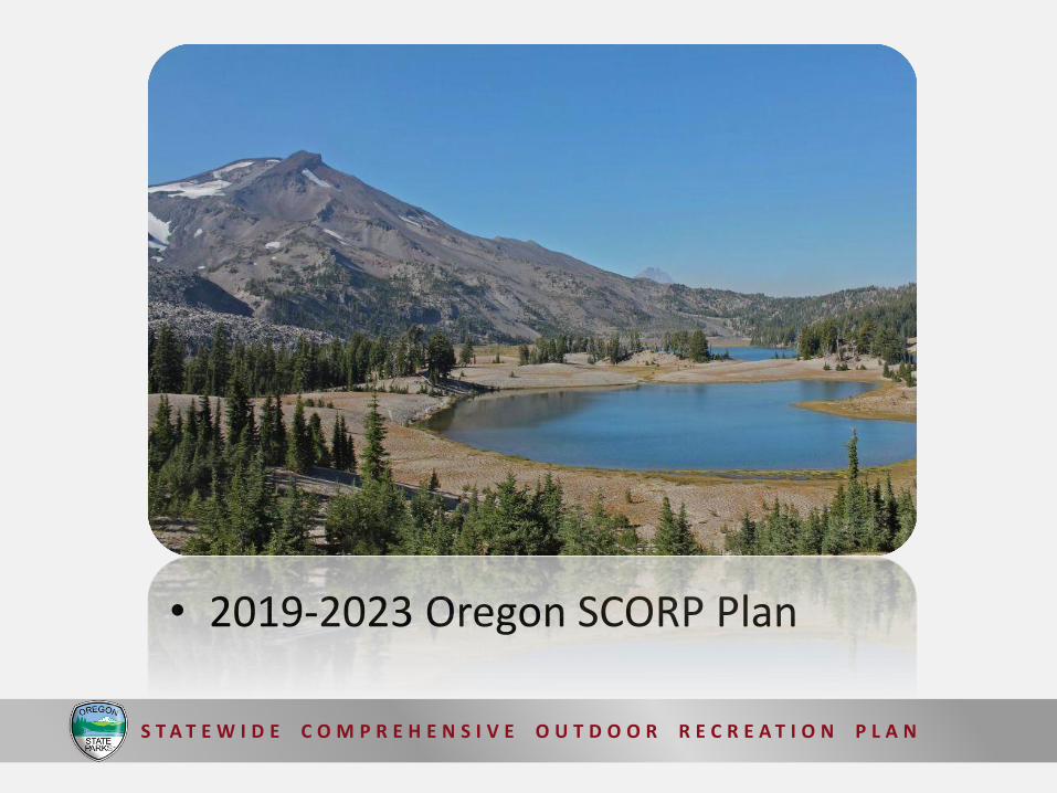
• 2019-2023 Oregon SCORP Plan

S T A T E W I D E C O M P R E H E N S I V E O U T D O O R R E C R E A T I O N P L A N
Oregon Parkland Mapping Project
From past SCORP planning surveys we know that:
• Many Oregon communities need assistance with park system planning.
• Many communities (30% of responding communities) do not have a recreation, open space, or management plan to identify recreation need.
• Of those with existing plans, many (54%) were more than 5 years old.

12
40
48
0 10 20 30 40 50
Percent
Don't Know
No
Yes
11
41
48
0 10 20 30 40 50
Percent
Don't Know
No
Yes
Oregon Parkland Mapping Project
2011 Needs and Issues Assessment Survey
In identifying the park and recreation needs of your service area, do you use any specific standards, or measures of deficiency?
Providers within UGBs
Providers outside UGBs

Oregon Parkland Mapping Project
Updated the planning guide in the 2013-2017 SCORP planning process

Oregon Parkland Mapping Project
Established LOS site guidelines for 11 standard parkland classification types

Oregon Parkland Mapping Project
Established LOS facility guidelines for 24 facility types
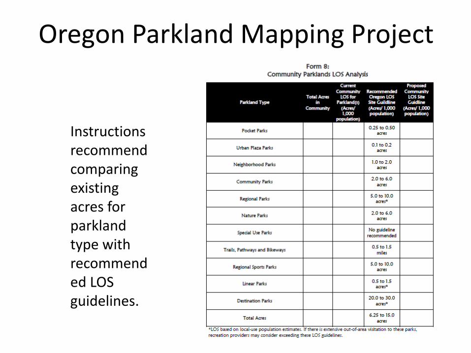
Instructions recommend comparing existing acres for parkland type with recommended LOS guidelines.
Oregon Parkland Mapping Project

Currently, there is no existing statewide parkland and facilities mapping database for Oregon
Oregon Parkland Mapping Project

Oregon Parkland Mapping Project
Available data appears widespread but lacks detail

With mapping coordinates for parklands and facilities, we could identify when the population resides too far away from specific parkland locations.
Oregon Parkland Mapping Project

Oregon Parkland Mapping Project
Potential statewide mapping database uses:
• Allow jurisdictions to generate LOS parkland and facility maps for park system planning.
• Identify target areas for addressing key SCORP issues.
• Provide land managers with critical information for cross-jurisdictional resource protection efforts.
• Provide a foundation for a one-stop website providing the public with information about park and recreation lands and facilities throughout the state.

Oregon Parkland Mapping Project
Key project components:
• Establish a technical advisory committee
• Develop GIS database standards for parkland data
• Finalize a parkland classification system and park amenities list
• Conduct a statewide spatial parkland and amenity inventory
• Assemble demographic data required for SCORP priorities
• Develop a mapping interface website for the project

PARKLAND LEVEL OF SERVICE STANDARDS
Parkland Type Recommended Oregon LOS Site Guidelines (Acres/ 1,000)
Pocket Parks 0.25 – 0.50 acres
Urban Plaza Parks 0.1 – 0.2 acres
Neighborhood Parks 1.0 – 2.0 acres
Community Parks 2.0 – 6.0 acres
Regional Parks 5.0 – 10.0 acres
Nature Parks 2.0 – 6.0 acres
Special Use Parks None
Trails, Pathways, and Bikeways 0.5 – 1.5 miles
Regional Sports Parks 5.0 – 10.0 acres
Linear Parks 0.5 – 1.5 acres
Destination Parks 20.0 – 30.0 acres
Total Acres of Parkland 6.25 – 12.5 acres

LEVEL OF SERVICE FACILITY GUIDELINES
Name of Facility Recommended Oregon LOS Facility Guidelines (Facilities/ 1,000)
Name of Facility Recommended Oregon LOS Facility Guidelines (Facilities/ 1,000)
Baseball fields 0.20 Picnic shelters 0.30
Softball fields 0.20 Day-use picnic tables 10.00
Basketball courts/ multi-use 0.20 Playgrounds 0.40
Soccer fields 0.20 Skateboard parks 0.04
Golf courses (holes) 0.60 Off-leash dog parks 0.04
Lacrosse fields0.15
Community recreation centers
0.03
Equestrian facilities 0.01 Amphitheaters 0.03
Football fields 0.10 Disc golf courses 0.02
Outdoor swimming pools 0.05 Boat ramp lanes 0.25
Beach areas for swimming 0.10 Non-motorized boat launches 0.25
Volleyball courts 0.20 Tent campsites 3.60
Tennis courts 0.35 RV/ trailer campsites 13.30

Map Layers
Oregon Parkland Mapping Project
Select City or County

Map Layers
Oregon Parkland Mapping Project
Neighborhood Parks
Parkland LOS Standards
Community Parks
Regional Parks
Nature Parks
Regional Sports Parks
Total Acres of Parklands
Picnic shelters
LOS Facility Guidelines
Playgrounds
Skateboard parks
Off-leash dog parks
Community recreation centers
Boat ramp lanes
Non-motorized boat launches
Tent campsites
RV/ trailer campsites
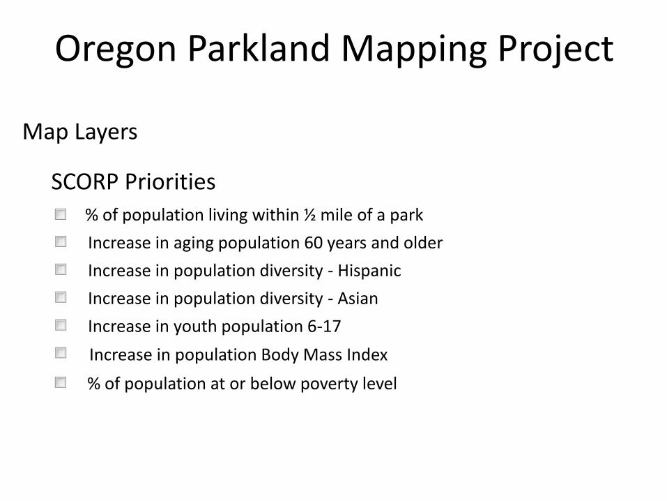
Map Layers
Oregon Parkland Mapping Project
% of population living within ½ mile of a park
SCORP Priorities
Increase in aging population 60 years and older
Increase in population diversity - Hispanic
Increase in population diversity - Asian
Increase in youth population 6-17
Increase in population Body Mass Index
% of population at or below poverty level

A mapping interface website would allow park jurisdictions to create LOS maps for park system planning.

Oregon Parkland Mapping Project
Inventory includes:
Federal Utilities
State Private
County Independent School
Districts
Special Park Districts State Universities
Municipal Community Colleges
Ports Technical Schools
Marinas Private Schools and
Colleges
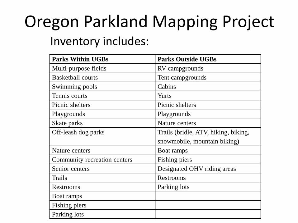
Oregon Parkland Mapping ProjectInventory includes:
Parks Within UGBs Parks Outside UGBs
Multi-purpose fields RV campgrounds
Basketball courts Tent campgrounds
Swimming pools Cabins
Tennis courts Yurts
Picnic shelters Picnic shelters
Playgrounds Playgrounds
Skate parks Nature centers
Off-leash dog parks Trails (bridle, ATV, hiking, biking,
snowmobile, mountain biking)
Nature centers Boat ramps
Community recreation centers Fishing piers
Senior centers Designated OHV riding areas
Trails Restrooms
Restrooms Parking lots
Boat ramps
Fishing piers
Parking lots

Oregon Parkland Mapping Project
Resulting Parkland GIS Data will be available as a Web Service

Oregon Parkland Mapping Project
Project Timeline

S T A T E W I D E C O M P R E H E N S I V E O U T D O O R R E C R E A T I O N P L A N
• 2019-2023 Oregon SCORP Plan

What types of parklands should be included in parkland LOS mapping for park system planning?
Oregon Parkland Mapping Project

What types of facilities should be included in LOS Facility Guideline mapping for park system planning?
Oregon Parkland Mapping Project
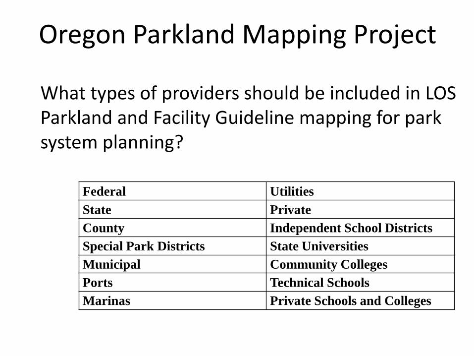
What types of providers should be included in LOS Parkland and Facility Guideline mapping for park system planning?
Oregon Parkland Mapping Project
Federal Utilities
State Private
County Independent School Districts
Special Park Districts State Universities
Municipal Community Colleges
Ports Technical Schools
Marinas Private Schools and Colleges

Census Data – Household Income
Oregon Parkland Mapping Project
Less than $10,000 $50,000 to $74,999
$10,000 to $14,999 $75,000 to $99,999
$15,000 to $24,999 $100,000 to $149,999
$25,000 to $34,999 $150,000 or more
$35,000 to $49,999
• Households below poverty threshold
What types of census data should be included in parkland and facility mapping analysis?

Census Data – Age
Oregon Parkland Mapping Project
Children 0-17 Adults 35-54
Adults 18-25 Adults 55-64
Adults 26-34 65+
• Families with children• 65 and older
What types of census data should be included in parkland and facility mapping analysis?
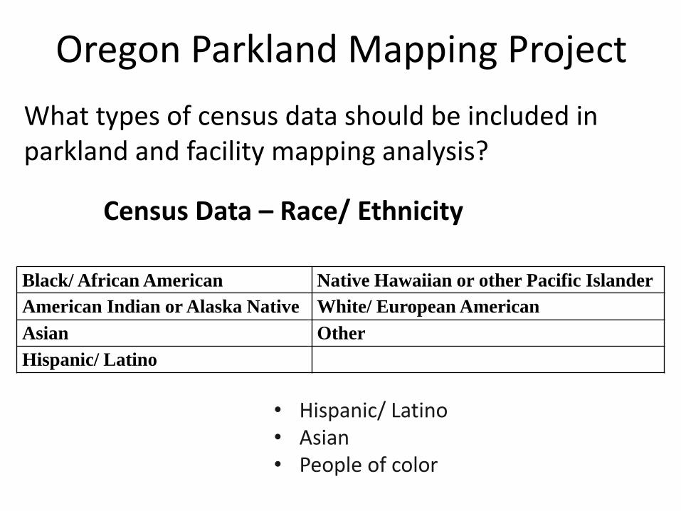
Census Data – Race/ Ethnicity
Oregon Parkland Mapping Project
Black/ African American Native Hawaiian or other Pacific Islander
American Indian or Alaska Native White/ European American
Asian Other
Hispanic/ Latino
• Hispanic/ Latino• Asian• People of color
What types of census data should be included in parkland and facility mapping analysis?

Census Data – Distance to parkland/ facilities
Oregon Parkland Mapping Project
• Percent of population living within ½ mile of a park/ facility.
• Percent of population living with a ½ mile walking distance of a park/ facility.
Key question: Distance to park boundary or distance to nearest park entry point?
What types of census data should be included in parkland and facility mapping analysis?

Oregon Parkland Mapping Project
Access & Barriers
TrailheadsParking lotsSidewalks
Vehicle TrafficWaterbodiesVegetation

Oregon Parkland Mapping Project
Cost Distance Approach

Census Data – Physical Activity
Oregon Parkland Mapping Project
• Body Mass Index• Percent of overweight/ obese living with a ½ mile
walking distance of a park or trailhead.
What types of census data should be included in parkland and facility mapping analysis?

Oregon Parkland Mapping Project
Map Layers
Neighborhood Parks
Parkland LOS Standards
Community Parks
Regional Parks
Nature Parks
Regional Sports Parks
Total Acres of Parklands
Enter Desired Parkland LOS StandardTotal Acres of Parklands (Enter a number up to 30 including up to two decimal points (e.g., 20.25).

Oregon Parkland Mapping Project
Results presented for the geographic area at the census block level.
2015
2020
2025
Enter desired census projection year

Oregon Parkland Mapping Project
In 2010, Oregon had 2,634 census blocks (3,831,074 population)
Portland population: 583,776Number of census blocks: 479
Salem population: 154,637Number of census blocks: 119
Burns population: 2,806Number of census blocks: 4

Oregon Parkland Mapping ProjectDistance from Park inside and outside of UGB

Oregon Parkland Mapping Project
>3000 acres
How do we create a discrete “Park” from dispersed recreation?
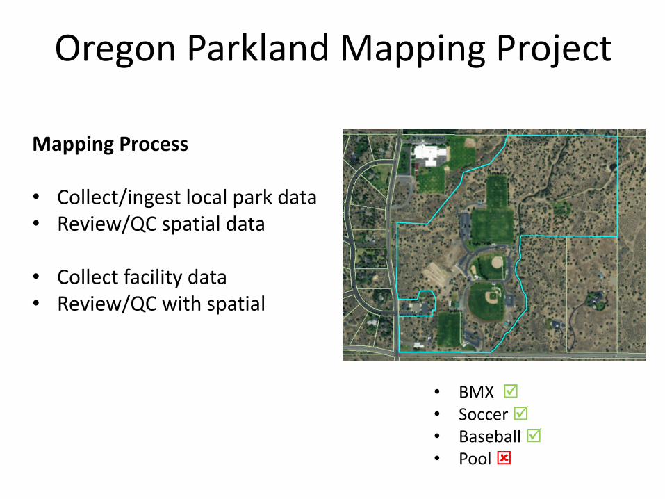
Oregon Parkland Mapping Project
Mapping Process
• Collect/ingest local park data• Review/QC spatial data
• Collect facility data• Review/QC with spatial
• BMX • Soccer • Baseball • Pool

Map Layers
Oregon Parkland Mapping Project
% of population living within ½ mile of a park (or ½ mile walk)
SCORP Priorities
Increase in aging population 60 years and older
Increase in population diversity - Hispanic
Increase in population diversity - Asian
Increase in youth population 6-17
Increase in population Body Mass Index
% of population at or below poverty level

Oregon Parkland Mapping Project
Name Organization
Scott Bricker Travel Oregon
Mo Sherifdeen Travel OregonRandy Rosenberger Oregon State UniversityJackie Rochefort Corvallis Parks and Recreation
Sheila Martin Portland State University
Randy Morris Portland State University
Rich Cvarak USFS - Region 6
Jennifer Magby Oregon Dept of Forestry
Advisory Committee