Embed Size (px)
Citation preview

2017 Year in Review for Central and Southeast Illinois By: Chris Geelhart, Meteorologist
National Weather Service, Lincoln IL
A La Niña pattern was in place for the 2016-17 winter season. This resulted in the second consecutive winter that was milder than normal, with only a fraction of the normal amount of snowfall. While the warmer weather continued into the spring, summer temperatures were close to normal. The dry winter gave way to a very wet spring, before the dry pattern returned for the second half of the year. Severe weather activity continued to be lower than normal, with only 14 tornadoes reported in the 35-county coverage area of our office.
Winter Season (December 1, 2016 to February 28, 2017) Temperatures: Much above normal
Precipitation: Below normal
Images courtesy Midwestern Regional Climate Center
An EF-3 tornado tore across portions of Woodford and Marshall Counties on February 28th, one of 16 tornadoes reported across the state that day. Photo by Cameron Nixon.

2017 Year in Review for Central and Southeast Illinois
National Weather Service, Lincoln IL Page 2
Temperature Review: Temperatures averaged 4-8 degrees above normal for the winter season. The first part of January did feature some colder weather, with lows near or below zero from the 6-8th. However, these temperatures quickly rebounded, and highs were back in the 50s by the 10th. By the 21st of January, widespread 60s were observed in most of Illinois east of the Illinois River, with temperatures approaching 70° across the southern third of the state. In February, exceptionally mild conditions were noted, with average temperatures of 8-12 degrees above normal. Peoria saw its warmest February on record, and Springfield had its 2nd warmest. Illinois as a whole saw its warmest February on record, with average temperatures 10.1 degrees above normal. The period from the 16-24th was especially notable, with many record highs. A high of 74 degrees at Peoria on the 20th tied the record for the month.
Weather Review: Snow was well below normal during the period, with areas south of I-72 seeing 5” or less over the course of the 3 months. In December, snowfall north of I-72 was 5-10”, but totals there were minimal in January. Peoria’s snow depth in January never exceeded a trace, a feat which hadn’t occurred since 1966. The only real snowfall of note in February was on the 8th, with totals of 2-4” in a wide band from Rushville eastward to Watseka. A large severe weather outbreak occurred across Illinois as February ended. On the 28th, 16 tornadoes were reported across Illinois; several of the ones north of I-72 were the farthest north occurring tornadoes on record in Illinois during the month of February. In central Illinois, the strongest tornado tore through Washburn, damaging 8 houses. This particular tornado was EF-3 strength, and was on the ground for 18 miles, and moved through parts of Woodford, Marshall, and La Salle Counties. Other tornadoes impacted areas near Castleton, Dunlap, and Rome.

2017 Year in Review for Central and Southeast Illinois
National Weather Service, Lincoln IL Page 3
Spring Season (March 1 through May 31) Temperatures: Above normal
Precipitation: Above normal
Images courtesy Midwestern Regional Climate Center
A dust storm, rare for this area, occurred across much of central Illinois on May 17. Photo courtesy of Paul Hadfield.
Temperature Review: March and April continued the trend of above normal temperatures, though not as abnormally above normal as February. The only real cold spell was from March 10-16th; the 14th and 15th saw lows in the teens, thanks to a fresh snow cover.

2017 Year in Review for Central and Southeast Illinois
National Weather Service, Lincoln IL Page 4
Weather Review: An intense line of thunderstorms raced across central Illinois between late evening March 6th, and early morning March 7th. This line of storms had originated in western Iowa and eastern Nebraska during the afternoon, causing significant damage along its path. Three tornadoes occurred in central Illinois, in Mason and Tazewell Counties. Snowfall of 3-5” occurred on the 13-14th, in an area from Galesburg southeast to Springfield and Decatur. Given the warm ground from the recent warmer weather, this only lasted a few days. A significant lake-effect snowstorm near Chicago on the 14th produced snowfall as far southwest as central Illinois, but only minor amounts occurred in our area. Severe weather occurred on several days. On April 10th, Canton reported tennis ball size hail. May 10th saw a line of thunderstorms producing wind damage from west central into southeast Illinois, and large hail and damaging winds occurred on May 26th north of I-74. During the last few days of April, very heavy rain fell over the Illinois River valley and in areas along and south of I-70, with 3-5” occurring. This contributed to Peoria seeing its 7th wettest April on record, where a total of 8.18” was measured. This wet trend continued into May, where 5-8” were common in many areas along and south of a Jacksonville to Danville line, with isolated totals near 10”. A rare dust storm impacted central Illinois on May 17th. Given the very dry conditions that had recently been occurring, plus bare soil due to the recently planted farm fields, wind gusts of 40 to 50 mph were able to easily pick up the topsoil. Low visibility resulted in numerous traffic accidents and road closures, including the closure of I-72 from Jacksonville to Springfield, and I-55 from McLean to Bloomington.
2017 Year in Review for Central and Southeast Illinois
National Weather Service, Lincoln IL Page 5
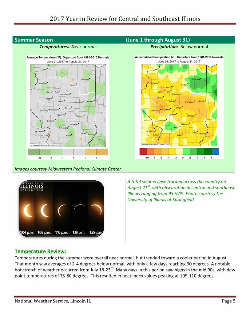
Summer Season (June 1 through August 31) Temperatures: Near normal
Precipitation: Below normal
Images courtesy Midwestern Regional Climate Center
A total solar eclipse tracked across the country on August 21st, with obscuration in central and southeast Illinois ranging from 93-97%. Photo courtesy the University of Illinois at Springfield.
Temperature Review: Temperatures during the summer were overall near normal, but trended toward a cooler period in August. That month saw averages of 2-4 degrees below normal, with only a few days reaching 90 degrees. A notable hot stretch of weather occurred from July 18-23rd. Many days in this period saw highs in the mid 90s, with dew point temperatures of 75-80 degrees. This resulted in heat index values peaking at 105-110 degrees.

2017 Year in Review for Central and Southeast Illinois
National Weather Service, Lincoln IL Page 6
Weather Review: After the wet spring, drier weather began to take hold in June. Less than an inch of rain fell in west central Illinois during the month. Severe weather was generally limited to a few days, with the most intense storms on the 17th. A wind gust of 75 mph occurred northeast of Bloomington, and a 68 mph gust occurred at the Flora airport. Clusters of strong to severe thunderstorms developed during the late afternoon of July 10th. The hardest hit areas were southwest of Peoria near Hanna City, northern Fulton County, and around Lincoln. A rain wrapped tornado moved across northern Peoria County near Princeville and Dunlap. Radar estimated that 70-80 mph winds occurred just north of Lincoln, and several downbursts in town caused extensive damage to hundreds of trees, power lines, and power poles. The high winds continued for about 15 minutes. Tennis ball size hail fell in northern Fulton County near Fairview. Rainfall during July was more abundant than June, but still below normal. The greatest rainfall occurred on the 26-27th, where widespread amounts over 2” occurred from Springfield southeast to Effingham and Flora. Not much improvement was seen in August, except in localized areas, and areas along the I-72 corridor were classified as being in moderate drought conditions. A total solar eclipse was observed on August 21st, in areas from Oregon southeast to South Carolina. While the path of totality did not track across central Illinois, the partial eclipse phase in our area ranged from 93-97% obscuration. Temperatures fell between 2 to 6 degrees in most areas during the height of the eclipse, with the greatest fall of 7 degrees occurring at the Champaign Airport.

2017 Year in Review for Central and Southeast Illinois
National Weather Service, Lincoln IL Page 7
Autumn Season (September 1 through November 30) Temperatures: Above normal
Precipitation: Mostly below normal, but near to above normal east of I-57
Images courtesy Midwestern Regional Climate Center
Persistent dry conditions led to lower than normal water levels on Lake Springfield in September. The official Springfield rainfall during the month was only 0.01”. Photo by Ernie Goetsch.
Temperature Review: September averaged 2-5 degrees above normal. While the month started cool, with some record lows in the lower 40s, a prolonged heat wave occurred from the 20-26th. Highs in the low to mid 90s occurred during this period, as high as 97 degrees at Effingham. The first few weeks of October remained abnormally mild, with upper 80s occurring as late as the 14th. However, a major pattern shift occurred during the last third of the month, and the first widespread freeze of fall occurred on the 29th. In November, record highs in the mid to upper 60s occurred on the 24th and 28th, but overall the month averaged near normal.

2017 Year in Review for Central and Southeast Illinois
National Weather Service, Lincoln IL Page 8
Weather Review: The dry conditions continued into September in many areas. Most of the area saw less than an inch of rain, with many locations less than a quarter inch. Springfield observed only 0.01” during the month. That was its 2nd driest month since records began in 1879, surpassed only by the trace of rain that fell in September 1979. Cumulative rainfall from June-September was 3-9” below normal in central Illinois. However, relief from the dry weather finally began to arrive in October, when rainfall of 4-6” was common. While the dry weather returned for November, lesser impacts were noted since the growing season had ended. Little in the way of severe weather was noted. October 14th saw numerous strong to severe storms northwest of the Illinois River, where wind gusts of 60-70 mph and penny size hail occurred. On November 5th, a supercell thunderstorm produced an EF-1 tornado in northwest Richland County. It tracked for nearly 7 miles before dissipating 3 miles north-northwest of Olney. Other storms in east central and southeast Illinois that day produced wind damage and hail up to the size of pennies. The first snowflakes of the season were reported on October 28th, and some minor accumulations of wet, heavy snow occurred around Bloomington on November 18th
Winter Season to date (December 1-31) Temperatures: Near normal
Precipitation: Below normal

2017 Year in Review for Central and Southeast Illinois
National Weather Service, Lincoln IL Page 9
Temperature Review: Mild conditions prevailed the first few weeks of December, especially from the 2-4th, when highs were in the 60s. Short periods of colder weather followed these 60s, but many highs in the 50s were reported from the 16-19th. However, a major pattern shift took place for the last week of the month. Temperatures below zero were reported in some areas on the 26-27th, and again on the 31st. New Year’s Eve was especially cold, with wind chills of 15-25° below zero. Despite this cold snap, temperatures averaged near normal for the month.
Weather Review: Dry weather continued during the first few weeks of the month, with precipitation amounts generally less than a third of an inch. Areas of the Illinois River valley from Beardstown to Peoria were especially dry, with totals less than a tenth inch. With the dry conditions, snowfall was especially limited, with many areas south of I-74 not receiving their first measurable snowfall until Christmas Eve. By the end of the year, areas from about I-72 northward had snow on the ground, with 5-6” snow depths along and north of I-74.
Preliminary Statistics for the Lincoln NWS Coverage Area:
Highest Temperature 100°F at Effingham (July 22)
Lowest Temperature -16°F at Minonk (December 27)
Most Rain in 24 Hours 5.37” at Avon (July 11)
Most Snow in 24 Hours
5.5” at Minonk (December 30)
Most Rain in 1 Month 10.31” at Danville 8N (May)
Most Snow in 1 Month
10.2” at Minonk (December)
Reported Tornadoes 14 By EF Strength: EF0=7, EF1=5, EF2=1, EF3=1. By County: Peoria 3, Tazewell 2. One each in Christian, Knox, Macon, Marshall, Mason, Morgan, Richland, Stark, Vermilion, Woodford. (Total is greater than 14 due to border crossers.)