Embed Size (px)
Citation preview

Annual
Report
Rogers Road: Mapping our Community’s Future
MAY 2016
The compilation of an intensive 9 month planning effort with community stakeholders
to create a shared vision for Rogers Road development for the next 10 years & beyond

1
Table of Contents Executive Summary ............................................................................................................................. 2
Primary Partners and Collaborators ................................................................................................... 3
Background and Process ..................................................................................................................... 5
Summary Recommendations ............................................................................................................. 7 Retains families who have lived here for decades/generations .................................................... 7 Connects us with each other and the larger community ............................................................... 7 Preserves socioeconomic & cultural diversity for the future ........................................................ 7 Respects the physical/natural character of the neighborhood ..................................................... 7
Detailed Recommendations ............................................................................................................... 8
Retain families who have lived here for decades/generations .......................................... 10
Connect us with each other and the larger community ..................................................... 13
Preserve socioeconomic and cultural diversity for the future ........................................... 18
Respect the history and physical/natural character of the neighborhood ........................ 22
Tools for Action ................................................................................................................................ 25 A. Zoning ....................................................................................................................................... 25 B. Land Use ................................................................................................................................... 26 C. Design Feel ............................................................................................................................... 28
Principles for Future Action ............................................................................................................. 33 A. Follow the stipulated priorities for future development ........................................................ 33 B. Ensure Accountability .............................................................................................................. 33 C. Maintain Open and consistent communication ...................................................................... 33 D. Support Community-First Planning ......................................................................................... 33
Appendices ........................................................................................................................................... i Appendix A. List of Unity Board Members/Participants ................................................................. i Appendix B. Glossary of Terms ..................................................................................................... iii Appendix C: Timeline ...................................................................................................................... v

2
Executive Summary In July, 2015, Orange County and the Towns of Chapel Hill & Carrboro requested that the Jackson Center
and RENA (Rogers-Eubanks Neighborhood Association) partner to facilitate a proactive community planning effort in the Rogers-Eubanks Neighborhood as sewer design and implementation makes
progress.
Partners proceeded to collaborate following the “Community-First” organizing model, which involves community members as principal actors in assessing and determining the course of future planning. Extensive collaboration and consultation led to four goals for future development: retain long-term
residents, connect us with each other and the larger community, preserve diversity for the future, and respect the natural environment. These in turn yielded a refined sense of charge and detailed recommendations. The collaborating partners are confident that the plans reflect a uniquely inclusive
and informed process.
This document was created to be a guiding and a working reference for invested community members and government partners in dialogue about next steps and specific plans. Key to its success is the
following set of principles, elaborated at the end of the document:
à Fol low the four stipulated priorities for future development
à Ensure accountability for collaborative action
à Maintain open and consistent communication
à Support community-first planning

3
Primary Partners and Collaborators
RENA
In 2007, the socially cohesive and culturally rich Rogers-Eubanks community founded the Rogers Eubanks Neighborhood Association (RENA) to formalize a long-term ad hoc community alliance and movement. As
a community organizing group, RENA needed a place to gather to provide a location for sharing of community resources and development programs. RENA organized social justice, service, and faith-based organizations in Orange County to form the Coalition to End Environmental Racism (CEER). This group
works to create community-driven events, which bring residents of the impacted communities together for the education of the wider community (citizens and local government officials) about critical issues of environmental health and justice. RENA also seeks and strongly values partnerships with local universities,
and has been engaged in four projects with partners at the Gillings School of Global Public Health at the University of North Carolina at Chapel Hill (UNC). RENA has successfully organized the neighborhood in victories to close the landfill, secure a community center, provide services for all neighborhood children,
and secure water and sewer for the Historic Rogers Road community, among many other successes and victories.
Robert Campbell, David Caldwell, Larry Caldwell, Rose Caldwell, and Jasmine McClain are the lead RENA
members on this planning effort.
The Jackson Center The Jackson Center is a public history and community development center located at the gateway to the
historic Northside of Chapel Hill, North Carolina. The mission of the Jackson Center is to honor, renew, and build community in the Northside and Pine Knolls neighborhoods of Chapel Hill/Carrboro. We want to make sure that the histories we hear, and the values and visions on which they are built, make a
difference in communities now and for generations to come. Our work is rooted in oral history listening and realized along three primary lines of creative community development: organizing and advocacy for livable neighborhoods, youth and education, and celebration and connection. In 2011, the Jackson
Center organized a coalition of dozens of organizations and hundreds of residents in an effort that led to the passage of a historic moratorium on development and community plan for Northside. This plan
dramatically changed zoning and increased support for neighborhood efforts. Between 2012-2015, the Jackson Center played a critical role in planning efforts that led to UNC’s $3 million land bank loan to Self Help Credit Union, which is helping to create dozens of affordable housing units and facilitating
neighbors’ control over land decisions. The Jackson Center has partnered with RENA, Orange County, Chapel Hill, and Carrboro on community engagement and planning efforts from 2014-2016. Hudson Vaughan and George Barrett are the lead Jackson Center staff on this project. Stephanie Barnes-
Simms, a community planner and Executive Vice President of Self Help, serves as technical assistance to the Jackson Center on this project.

4
Tim Stal lmann
Tim Stallmann is a freelance cartographer based in Durham, NC. His work focuses on using maps as tools
to build community power around racial, economic and environmental justice. Tim has worked with the Jackson Center since its founding, and has also participated in the 2014 community survey project that produced Historic and Vibrant Rogers Road. His maps and his collaborations with the Counter-
Cartographies Collective, of which he is a founding member, have been widely published and exhibited. Tim holds a Masters degrees in Mathematics and Geography from Duke University & UNC-CH, respectively. In addition to consulting, he also teaches map-making at the Center for Documentary
Studies at Duke University. For more of his work, see www.tim-maps.com.
Community Unity Board
The Community Unity Board is a group of neighborhood leaders from all across the Rogers Road
neighborhood. The Board was originally formed in 2013-2014 to bring together residents of all of the sub-neighborhoods of Rogers-Eubanks in ongoing dialogue and partnership. RENA & the Jackson Center re-initiated this board for this specific planning effort, inviting residents from various sub-neighborhoods
to take a stake in Rogers Road’s future and to be in ongoing dialogue with their neighbors. This group of nearly 20 residents, most of whom have been actively engaged in ongoing community efforts in Rogers Road, took part in 9 intensive meetings over the course of the last seven months and several additional
consulting sessions and interviews.

5
Background and Process For the last 9 months, a core of neighborhood residents and other key stakeholders have gathered for
intensive dialogue about our hopes and fears for our community, the strengths and struggles of our history, and the diverse visions we have for the future of the Historic Rogers Road Community. We
initially planned to participate in four intensive meetings over four months. In order to reach a variety of stakeholders and ensure sufficient discussion depth, we adapted this strategy to nine sessions focused on creating, reviewing, and strategizing together.
Many of the primary stakeholders have
participated in planning efforts for decades. Throughout the process in Rogers Road, we faced a great challenge together: the collective feeling -
and reality among constituents - that planning efforts in Rogers Road have consistently fallen short on implementation. We discussed questions
like: What is the point of this effort? Will the three governments respect our visions and actually help us achieve them? Will sewer really happen or is
this process a trick to focus us on development instead? Will this just become another plan
shelved for people to reference in their articles about the struggles of Rogers Road?
While some of these questions remain, our dialogue about these questions led us to clarify our common understanding and our group’s charge for moving forward. Our focus and group charge for the effort was to work together to create:
• A collective answer to the question of what would we like to see from any future development in the form of a
crisp list of easy to explain priorities that we can remember.
• A map of our vision for future development/improvements. We are working on being able to describe both
what we want and where we would like to see it happen
• A specific action plan that describes how we achieve our aspirations, including specific action steps, with “gives
and gets,” or realistic trade-offs, for neighbors, local governments, and developers
We used the model of Community-First Planning that that the Jackson Center developed for use in the ongoing Northside Neighborhood Initiative. This model is built on an intensive set of communication and organizing tools that bring neighbors and other stakeholders into active and realistic planning discussions
focused on change that enhances community and regional goals. Unlike external, top-down, or selective representative processes, Community-First Planning features broad-based participation developed on the ground in direct communication with residents and stakeholders, “reverse-consultancy” leadership
(funding for on-site existing community leaders as primary consultants), and a direction-setting group that remains accountable to community interests. Accordingly, RENA and the Jackson Center worked for
Neighbors in a discussion about land control and conservation.

6
several months to identify major stakeholders, sub-neighborhood representatives, and neighbors who could bring an array of visions and opinions into dialogue with one another. We ultimately invited 19
people to participate in ongoing meetings together and asked them to take the ongoing questions back into their sub-neighborhoods to more intensively reach stakeholders who may not attend. We then conducted over a dozen additional interviews to incorporate perspectives of residents who were not able
to be part of the stakeholder team. Because of Rogers Road’s long history of neighborhood leadership and action, our process engages the strengths and struggles of
history first and continually. Creative communication strategies are a central part of our work: we find ways to reach people the ways they best receive contact. We
develop clear “gives and gets” strategy framework. We believe that discussing the benefits and challenges openly is the best way for communities to mobilize for movement
forward, and we believe in building this infrastructure in a
way that it can be utilized well beyond our active role.
This is not the first effort at a plan for the Rogers Road
neighborhood. As mentioned above, the neighborhood has long experienced marginalization from the political and planning process. Conventional decision-making has been for and about neighbors rather than with and by neighbors. We entered into this
process well aware of the history of racial exclusion, and always with the nagging fear that the results of our efforts would be more of the same exclusion. In spite of that fear, we were willing to complete this Community-First planning effort because of the following:
• The assurance that sewer infrastructure would continue to move forward for Historic Rogers Road
residents, and that a community effort was an important step in preparation for development speculation
that might result with this new infrastructure
• The understanding that this effort would help guide future conversations about land use planning and
development approvals, especially in the Greene Tract and on the Chapel Hill side of the neighborhood,
given the recent change to an ETJ and concerns about future zoning decisions in Chapel Hill without prior input
• The desire to “get ahead” of the rising development pressure, given the growing concern in the
neighborhood about what is happening all around the fringes of Rogers Road, especially the significant rise of new subdivision and townhouse developments on Homestead and Eubanks Rd
• The hope that we could create a guiding document together that would be immediately useful for us as
residents and community partners
Part of how we approach planning is to engage differences and to value a diversity of community opinions, not to try to get rid of it or find absolute consensus. The materials and recommendations in this
document do not “represent” all of Rogers Road. This process has engaged a wonderfully diverse set of neighbors in ongoing dialogue and sought to create a document that elaborates on shared visions; it includes differences and nuances that have enriched the discussions.
Neighbors workshopping summary recommendations at an early meeting.

7
Summary Recommendations These summary recommendations were created through a review of historical documents and processes
and several Community Unity Board meetings. Once the Unity Board established a draft, this list of priorities was shared widely for feedback and revision: with their sub-neighborhoods, on the community
listserv, through the community newspaper, and in individual interviews. The following is the result:
"We want development that we are a part of , not the v ict im of." -David Caldwell
We want development that…
Retains famil ies who have l ived here for decades/generations
• Supports owners in maintaining their homes and mitigating rising cost of living • Creates economic opportunity for people living here • Provides opportunities and services for elders to age in place/in the
neighborhood
Connects us with each other and the larger community
• Improves bus service & roads, pathways, and sidewalks to connect us to key places and to one another
• Ensures new development opens to and connects with the existing community, avoiding internal fragmentation
• Promotes intercultural connection and multi-culturalism
Preserves socioeconomic & cultural diversity for the future
• Prioritizes the creation of diverse affordable home options • Expands the community center and provides additional services for
neighborhood children • Ensures access to essential social and retail services • Provides space for smaller local businesses to start-up and serve the local
community
Respects the physical/natural character of the neighborhood
• Balances land conservation with density to reduce suburban sprawl • Minimizes disruption to the natural landscape & opens environment to
people's use and enjoyment • Promotes design that fits into the character and fabric of the existing
community • Honors history and contributions of neighborhood in tangible ways

8
Detai led Recommendations This section, organized into four guiding principles, provides specific suggestions and recommendations on ways that the Towns & County, neighborhood residents, and any future developers can realize the goals identified by Rogers Road residents.
Retainfamilieswhohavelivedherefordecades/genera5ons
Connectuswitheachotherandthelargercommunity
Preservesocioeconomicandculturaldiversityforthefuture
Respectthephysical/naturalcharacteroftheneighborhood

9
Overview Map

10
Retain families who have lived here for decades/generations
Support homeowners in maintaining their homes and mitigating rising cost of living
Develop and fund home repair programs, especial ly to improve in-home
accessibi l i ty for long-t ime residents. In the 2014 survey of the Historic 86 parcels, over 65% of households in the Historic Rogers Road area reported a need for some home repair support, including but not limited to: essential repairs of leaking roofs, broken HVAC
systems, $500 utility bills due to a lack of weatherization, and increasingly inaccessible houses for those who are aging and disabled. Given the scope of need, Rogers Road would be a great focus area for a targeted home repair effort by an organization like Habitat or
Rebuilding Together, with support from the County and/or Towns. This effort should be proactive and utilize RENA’s existing database of home repair needs.
The County and Towns should create a unif ied fund for home repairs in Rogers Road so that neighbors’ abi l i ty to get repairs is not dependent on
where the house is located within the neighborhood. Currently, Rogers Road is split between Carrboro and Chapel Hill’s ETJ, leaving the community in the middle of CDBG and other funding efforts. The County could take the lead to host a unified fund to address
the challenge of the multiple jurisdictions.
Strengthen community organiz ing infrastructure by support ing the Rogers Road Community Center, especially to increase volunteer networks and provide
sustainable presence in neighborhood. The Rogers Road Community Center has been a hub of action, but it needs regular operating support to continue to thrive.
Create property tax mit igat ion program for long-term neighbors to offset
r is ing taxes as result of development. Durham is currently working on a proposal to offset the rise in taxes for elderly, low-income residents over a period of time due to rising property values. Given the potential of development speculation, a similar program should
be implemented to limit the drastic increase in taxes that could result from development pressure, both for elderly low-income residents and their heirs. The County could also lead a proactive effort to ensure residents who qualify for the Homestead Exemption have this
important tax exemption.
Support efforts to prevent land loss. Across the country, historically African American communities are losing land at a rapidly accelerating pace through investor speculation, heirs’ property complications, and policies of exclusion. We are already
beginning to partner with the Black Family Land Trust, Conservation Trust, and Center for Civil Rights to assist us, protecting land rights and use for future generations.

11
Create economic opportunity for people living here
Ut i l ize exist ing ski l ls and leadership of residents. We, residents of Rogers Road, have a vast array of skills and experience: in engineering, business and non-profit
management, construction, nursing, elder care, and more. Any jobs created through building and development should utilize existing skills and leadership of residents.
Provide opportunity for community business ownership and management in new business spaces, especial ly any on publ ic ly-owned land. Not all of us are
interested in area retail, but all support the idea that, if there were to be any small, mixed use spaces, these spaces should be designed and structured in a way that provide true accessibility for community ownership and management.
Consider updating zoning and s ignage restr ict ions to g ive more f lex ibi l i ty to community-owned businesses. Current zoning allows for some home-based businesses but restricts signage. Zoning and signage regulations should reflect the benefit
that small, community-owned commercial spaces can bring to the neighborhood.
Provide opportunities and services for elders to age in place/in the neighborhood
Pursue a proactive effort for publ ic-pr ivate partnership with model senior l iv ing, especia l ly with Piedmont Health. Senior housing, independent but supportive, is a huge priority. The partner would need to be a provider/developer
committed to serving neighborhood residents and affordable spaces, not simply high-end senior needs.
Ensure zoning al lows for e lder development or services that increase l ivabi l i ty and accessibi l i ty of these long-term neighbors. This is the one form of
housing that residents, even those that were wary of any increase in density, were interested in finding a way to support.
Support locat ion of a community-health faci l i ty in the community. St. Paul’s
Village already has a proposed community-health center planned in partnership with Piedmont. Increased support from the governments to make this possible in the near future would be beneficial to all parties.

12
Development Do’s Development Don’ts
Senior housing: single story, primarily independent units (see design feel document); additional safety and
accessibility needed if more than one story
Community-commercial spaces near senior housing
Housing for veterans and homes accessible to people
with disabilities
Co-housing model for shared services among
community
Community-health clinic
Requirement of community benefits agreement for
new development that includes tangible ways the new development will support neighborhood retention
strategies
Development that will significantly raise area taxes without creating a tax mitigation plan in advance
Development of new affordable units without
significant investment in the repair of existing homes

13
Connect1 us with each other and the larger community
Improve bus service & roads, pathways, and sidewalks to connect us to key places and to one another
Build a new road into the Greene tract from the East, preferably one that ut i l izes exist ing pathways or c lear ings. New development on the tract
– even just for recreational use – will increase traffic into the neighborhood, largely from the MLK Boulevard corridor. Purefoy Drive is not suited to handling through-traffic into the Greene tract at this level, nor should it be. Expanding this
road without connection to the other side would endanger the neighborhood patterns, safety, and feel. The best design for a new road would connect Purefoy
Drive on the West with Weaver Dairy Extension on the East, a route that passes through Town and County-owned land exclusively (except for the railroad crossing). An alternate route would be a North-South connector from Eubanks into
the Greene tract.
Improve bus service to the neighborhood that connects with T imberlyne and employment centers. Chapel Hill Transit is already taking some steps in this direction, following on the heels of organizing by RENA and
Justice United. The routes could still be improved to connect to essential retail services and employment centers.
Add bus shelters at the bus stops along Rogers Road. Currently, young
children and elderly neighbors stand by the curb signs without any shelter from the rain or a bench to rest upon. Adding attractive bus shelters would improve safety, increase ridership, and improve aesthetics of Rogers Road. This should be an immediate action in the near future.
Create greenway and walking path improvements throughout the neighborhood. Residents recommended using existing utility easements as walking paths. These would ideally be unpaved and minimally improved to retain
the rural feel of the neighborhood, but officially designating these as paths and adding signage would increase recreational opportunities for residents as well as aiding privacy since folks who are walking through the neighborhood would use
walking paths rather than cutting through residential lots. Ideally, greenway improvements would allow pedestrian access – on walking paths or sidewalks the
1 Connectiv ity: Connection is often limited to physical infrastructure. A new subdivision is sometimes considered “connected” if it ties into the main road and has access to Weaver Dairy, for example. The term here means more integration of spaces: connection that is physical, social, and cultural. Connectivity prioritizes historic Rogers Road residents and requires integration of new development into the existing fabric of the community.

14
whole way – from the neighborhood to Timberlyne and the MLK Boulevard area. Easements and existing pathways on Greene Tract should be made into walking
trails or greenways that provide a walking loop through natural areas accessible to neighbors.
Improve s idewalks. Complete sidewalks on both sides of Rogers Road – this would improve walking access to bus stops and the community center and help
keep children out of the road. Additional sidewalks should be networked with greenways to provide full range of connections through the neighborhood.
Increase traff ic enforcement in the neighborhood. The blinking speed
sign works well on Rogers Road but there is still a need for more police presence and speed reduction mechanisms on Rogers and Purefoy.
Consider adding traff ic l ights at the intersect ions of Rogers Road and Merin Road with Homestead Road. These intersections are difficult left-
turns that are part of the daily commute of residents. Traffic lights or other measures to improve traffic flow would help safety and convenience. The Merin Road and Homestead intersection, unfortunately, presents some difficulties
because of the railroad tracks immediately adjacent; we recognize that a traffic light may not be feasible there.
Ensure new development opens to and connects with the existing community, avoiding internal fragmentation
Require that new development have c lear physical integrat ion with exist ing neighborhood, increasing connection instead of segmenting it. The
physical integration of Phoenix Place was a good example of this. The new Burch Kove development is a development that does NOT promote this kind of integration.
Ensure that any new development does not bui ld wal ls/barr iers ; l imit culs-de-sac where connection is possible . Rogers Road is a diverse and inclusive community, and we believe structures have the power to connect or
divide us. Several years ago, there was a proposal to redevelop one of the large heirs property into a subdivision with a wall surrounding it and a set of culs-de-sac for the center of the development. This kind of exclusion should not be possible in
future development.
Development should show clear integration with the exist ing fabric of the community and indicate ways it wi l l enhance socia l
connectiv ity . In our meetings, we discussed the problems of the social integration of Winmore and how residents of the affordable housing development within it are limited in their use of common facilities and do not feel connected or

15
welcome in the high-end space. Any new development in Rogers Road should be fully integrated and not create exclusive benefits for its own residents but instead
contribute to community improvements and accessible recreation spaces.
Promote intercultural connection and multi-culturalism
Increase space for community gatherings and support intercultural fest ivals and community events. We have always been a community of celebration. As our community has grown, we have continued to find ways to
extend our festivals and community events to all who reside in Rogers Road and have a stake in its future.
Add mult i- l ingual s ign welcoming people to the neighborhood in the many languages of our community . Our community is one of the most
ethnically diverse in the whole County. Signage should reflect and support this diversity in the major languages of our community. This should be an immediate action item, integrated with the building of neighborhood gateways.
Provide opportunit ies for mult icultural businesses in any community-commercial spaces. This would take proactive engagement with the diverse groups of people who call Rogers Road home and would help make any
such businesses successful.
Provide educational opportunit ies about the community’s h istory. RENA has partnered with UNC to document our oral histories. These efforts can be expanded, sustained, and given space to be brought into dialogue with the
broader community.

16
In our meetings, residents associated connectivity with both positive and negative aspects. Road
connectivity, done poorly, could come with the cost of increased traffic, and detract from the rural feel of Rogers Road, which is one of the assets all neighbors valued. One resident, in a mapping activity, drew a bicyclist riding down Eubanks Road and “biking right on past our neighborhood;” this illustration
showcased the desire of many residents’ to keep the community feel of the neighborhood rather than add numbers of new outsiders using the land for recreation. For the most part, residents framed connectivity improvements as an if-then situation: if there were new development on the Greene tract
area, then new road connections would be necessary so that Rogers Road doesn’t become overburdened.

17
Development Do’s Development Don’ts
“When government builds something, there must be egress and access.”-Mr. Stroud.
Extension of Purefoy Dr. into Greene Tract, connecting to Weaver Dairy Extension
Extension of services. Ex. Buses
Trails on existing pathways.
Access to green spaces and nature, adding trails and
greenways
Retail along Purefoy Dr without a road connection east.
Development that would require the widening of
Purefoy Drive.
Development without expansion of road through
Greene Tract. Fear of development if Purefoy remains the only point of access.
GATES or WALLS! Fear of a closed community!
Development should NOT make the original residents feel unwelcome in their own neighborhood.

18
Preserve socioeconomic and cultural diversity for the future
Prioritize the creation of quality affordable homes
Maintain the level of socio-economic divers ity of the exist ing
community within any new residentia l bui ld ings. This would require a higher percentage of affordable units than currently required for affordability (upwards of 25%). It would also necessitate a significant percentage of units
accessible to households below 50% AMI.
Create affordable homes2 for famil ies. These homes should be accessible to 50% AMI, primarily with 3 br/2bth, and integrated with any market homes
Require median home price on a development to be accessible to
the median income of the community. To maintain the socio-economic diversity, new development must provide a similar mix of housing accessible to a range of residents
Provide co-housing options for working c lass and elderly, with
shared common spaces to decrease costs. Most co-housing models are primarily aimed for middle-upper income households, but the model could be for shared common spaces and modest density in Rogers Road should be primarily in
the service of the elderly and working class
Consider requir ing a community impact or racia l equity impact study as part of the evaluation process for new development in the
neighborhood. Development decisions should consider what impact the new development will have on the community as a whole.
2 Affordable Homes: There is a difference between affordable housing and affordable homes, and “homes” is used purposefully here. Affordable homes necessitate a certain quality, wholeness, and connection with the community around them. Rogers Road has been home to generations of residents (indeed, over 80% of residents have historic ties to the community). Whatever new housing is built in the neighborhood must be suited for families (3 bedroom, 2 bath as the primary model, with a smaller model for elder housing) and also be integrated into the fabric of the existing community. A next generation of residents should want to live in these homes. Also, the standards for affordability used in new development should further the existing socio-economic diversity in the neighborhood (including a significant percentage of households earning below 50% AMI) – which will necessitate more careful and creative approaches than the standard 60-80% AMI metric.

19
Expand community center and provide additional services for neighborhood children
Add a wing to the community center or addit ional space in new school or other development to provide space as community grows.
If new development is approved, it should contribute significantly to the growth of shared community spaces, either financially or by creating spaces accessible to all. The development of a new school should also have to provide significant
community space and benefits.
Increase services for chi ldren that serve both neighborhood chi ldren and provide job opportunit ies for residents. There is a great need for affordable daycares and spaces of recreation for high school age children. We
have also heard talk for years of the possibility of a neighborhood school. Any actual proposal for a school should be planned in close dialogue with us and other
neighbors, in order to address concerns about impact, equity, and connection to the community. Any services should utilize the wealth of educational leadership and teaching experience in the neighborhood.
Provide publ ic park and recreation space. Currently, the only outdoor
park is located within the Habitat community and is not a public space. This park should be made more accessible; additional land in the Greene Tract should also be preserved for public park use.
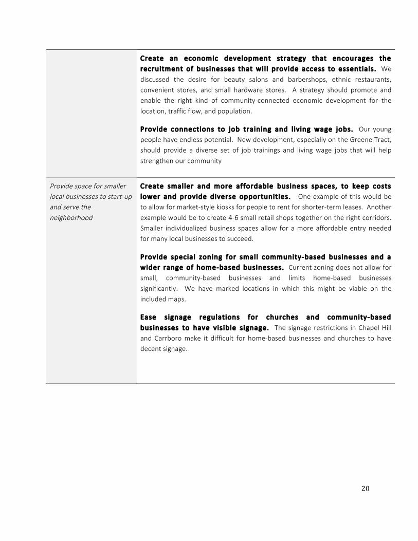
Ensure access to essential social and retail services, with a priority on community-commercial3
Provide dist inct ive areas within walk ing distance that can serve
community commercial . Many of us would love to be able to walk to get essentials. Our maps show a few distinctive spaces accessible to the community in which this kind of commercial may be appropriate if economically viable.
Partner with agencies that have a track record in managing and operating community-based commercial . Who owns and manages any commercial will be critical to its success. If any retail is included on the Greene
Tract, then the governments should be careful in partnering with trusted partners and maintaining some control over these spaces, consistent with community development principles.
3 Community Commercial : While there are a range of opinions about the presence of retail and commercial generally in the neighborhood, there was strong support for the existence of modest, community commercial spaces that allow for small, local businesses to serve the community. Examples given have included hair salons and barbershops, small ethnic restaurants, hardware store outposts, community health clinics, small outdoor markets, and kiosk-size spaces for short-term use (such as flower shops) to support entrepreneurship. We use the phrasing “community commercial” here to highlight that the goal is to serve the neighborhood, provide employment opportunities, and ensure that affordable commercial space is available long in the future. Meeting those goals will likely necessitate a different model from traditional commercial retail, either involving a nonprofit developer, subsidies, or both.
20
Create an economic development strategy that encourages the recruitment of businesses that wi l l provide access to essentia ls . We
discussed the desire for beauty salons and barbershops, ethnic restaurants, convenient stores, and small hardware stores. A strategy should promote and enable the right kind of community-connected economic development for the
location, traffic flow, and population.
Provide connections to job training and l iv ing wage jobs. Our young people have endless potential. New development, especially on the Greene Tract, should provide a diverse set of job trainings and living wage jobs that will help
strengthen our community
Provide space for smaller local businesses to start-up and serve the neighborhood
Create smal ler and more affordable business spaces, to keep costs lower and provide diverse opportunit ies. One example of this would be to allow for market-style kiosks for people to rent for shorter-term leases. Another
example would be to create 4-6 small retail shops together on the right corridors. Smaller individualized business spaces allow for a more affordable entry needed for many local businesses to succeed.
Provide special zoning for smal l community-based businesses and a wider range of home-based businesses. Current zoning does not allow for small, community-based businesses and limits home-based businesses
significantly. We have marked locations in which this might be viable on the included maps.
Ease s ignage regulat ions for churches and community-based
businesses to have v is ib le s ignage. The signage restrictions in Chapel Hill and Carrboro make it difficult for home-based businesses and churches to have decent signage.

21
.
Development Do’s Development Don’ts
Community commercial. Limit to 3-4 shops. Ex. Barbershops, Beauty supplies, family owned business.
Affordable Homes: Workforce, teachers, early career, and seniors. Affordability defined as who can access housing.
Daycares, parks, and community center expansion: spaces for neighborhood children
Diversity of housing: not one housing type. Variety in
design. Connects to the variety of housing that exists within the neighborhood.
Single-family style for affordable housing
Development catered to one demographic
Large-scale commercial. Big businesses (Supercenters)
a consistent fear. Ex. Timberlyne borders on being too large for this community; Walmart/Target are way too
large.
Development that provides destination retail or
attracts large amounts of people from outside of the community (would add too much traffic).
Gathering space with only one point of access

22
Respect the history and physical/natural character of the neighborhood
Balance land conservation4 with modest density to reduce suburban sprawl
Respect identif ied areas of land conservation through conservation
easements and other appropriate protections. Currently, areas with a priority of conservation are not formally protected. Conservation easements for large parts of
the Greene Tract and for heirs property (where owners desire them) could help achieve some of the long-term hopes of maintaining large portions of the natural surroundings.
Designate specif ic areas for modest density, to increase diversity of
opportunity. We do not want the suburban sprawl taking place on the fringes of Rogers Road. Designated areas for modest density, crafted carefully, could increase diversity of opportunity & affordability, limit land disturbance, and support the mixed
community so many of us desire.
Minimize disruption to natural landscape & opens environment to people's use and enjoyment
Maintain a wooded buffer on the eastern edge of the Sandberg Lane port ion of the neighborhood. Residents along this gravel road have long enjoyed the privacy that comes from their sparsely-developed neighborhood, and any new
development in the Greene Tract should not infringe on that.
Ensure that large parts (80%) of the Greene tract are permanently preserved as open, natural , space. We, and many other community members,
have long used the Greene tract for recreation, education, enjoyment and even as a food supply. This vacant land is a unique opportunity for residents, working with local government and groups such as the Black Family Land Trust and the Conservation
4 Conservation: The undeveloped land in Rogers Road is not vacant: to the contrary it has a wealth of value for residents of Rogers Road and surrounding communities. For generations this land has played an important role as a site for recreation, for gathering food, and for contemplation. Conservation on the tract should acknowledge and build on this cultural value without disturbing the rural feel of the area – not creating a sectioned-off or walled-off part of the community, but keeping large portions of these lands open for enjoyment and connection to the natural world, while protecting this special environment. Promoting “development that we are a part of, not the victim of” means honoring, preserving and amplifying the cultural and natural assets held by the Rogers Road community. This community aim is detailed under the rubric of conservation. However, as the glossary discusses, conservation in this context has a much broader meaning than the strictly environmental preservation, which has often been a strong consideration in planning decisions for Chapel Hill, Carrboro and Orange County.

23
Trust for North Carolina to devise an innovative conservation plan which centers the value of the land to the area’s Black residents. Already, residents have identified a few
areas for special conservation priority, which are sketched on the map, but more field- work is needed to specifically identify their boundaries.
L imit how much c learing of land is possible. Some developments have limited the clear cutting of land and ensured a large portion of existing trees remain.
This would be our preference. Additionally, some development possible in the Greene Tract could be shifted north to the Neville Tract to utilize existing cleared land and allow for increased conservation of woodlands and wetlands.
Honor history5 and contributions of neighborhood in tangible ways
Add gateway markers on the northern and southern ends of Rogers
Road to honor the neighborhood and celebrate those intersect ions as entrances to a cultural ly s ignif icant, h istorical ly Afr ican-American neighborhood. Some of Orange County’s most well-known brick and rock masons
are connected to the Historic Rogers Road community. These and other legacies should be honored.
Identify & preserve s lave graves and other historical ly s ignif icant s ites.
Marked as cultural preservation sites in previous planning efforts, these historic areas have still been overlooked. The graves of enslaved Africans are sacred sites and need to be identified and honored with markers and continued preservation. If these graves
cannot be found, a memorial should be created in their honor. These efforts should include neighborhood leadership throughout the entire process: both in deciding how to identify and research these sites in a culturally sensitive way and in deciding how
best to honor them. St. Paul’s church is exploring some ways to do this with respect to sites on land they own.
Add s ignage that identif ies this as “Historic Rogers Road” and Integrate
community-specif ic h istorical markers throughout the neighborhood. Rogers Road community has a rich history, which is rooted in place, but often not immediately visible to passersby or visitors to the neighborhood. Marking this history
can be a way of preserving it for the future.
5 Honors history: Honoring history in tangible ways refers to more than just physical markers, signage, and history exhibits, although these are important. It also means that any development must show alignment with community goals and be something historic Rogers Road residents take pride in.
Preserves diversity: To continue to promote and ensure the existing diversity into the future; to further the remarkable socioeconomic and cultural diversity that is already present in Rogers Road.

24
Development Do’s Development Dont’s
“Preservation means leaving it the way it is, but making
it also accessible to the public.” - Carl Purefoy
Gradual Process. Integrated design.
Greene Tract: High priority for preservation. Dense
development - not too much. Infuse with existing characteristics of natural environment.
Development on Neville Tract instead of southwest area of Greene Tract. Utilize the existing clearing on the
Neville Tract to preserve more wetland and forest
Development accompanied by buffers.
Development consistent with historic vision and
existing neighborhood character (including height, diversity of building materials & types)
Community Markers: Historical markers. Preservation
of slave graves. Cherry Orchard.
Requirement of community impact study for any major
development before approval
Privacy: “Being able to go out in your bathrobe without
being watched”- Ms. Reid
Businesses that interfere with surrounding
homeowners. Fear of strangers invading property.
Development that destroys community feel.
Removal of the historic community & existing street
names. Fear that new development will seek to wipe out historical names.
Block flow of streams and water run-off. Fear of flood areas during intense rainstorms.
Removal of significant woods in the Greene Tract
Large multi-story housing developments. This takes away from the family feel. (ex. Greenbridge)
Mini-mansions
Large amounts of artificial lights
Suburban sprawl. (Burch Kove, Homestead).
3+ floors for housing

25
Tools for Action
A. Zoning
As the map above shows, the Rogers Road neighborhood is mostly zoned Chapel Hill R-1/R-1A or Carrboro RR, zoning classes which allow up to 3 units per acre and lot sizes as low as 17,000 square feet. This existing zoning allows development-by-right of a kind that is potentially inappropriate for the
community. The upcoming Merin Road development on the neighborhood’s outskirts – which conforms with the density of R-1 but has lower lot sizes – matches pretty well with what residents described as one of their worst fears for new development in the neighborhood (the others being mini-mansions and
monolithic mixed-use developments like Greenbridge or Meadowmont). Residential areas should be zoned in a way which imposes more specific limits than R-1 or RR on both square footage and density, (perhaps a minimum lot size of 30,000 square feet) by default, but which increases neighborhood input
throughout the development review process and allows for exceptions with the neighborhood’s approval. On the Chapel Hill side, this could potentially be done through a Neighborhood Conservation District.

26
The Greene Tract is currently zoned in a way (RT) which would allow for development matching residents worst fears – in this case an expanded landfill (albeit with a special use permit requirement).
Conservation of the Greene Tract will likely need to take place through conservation easements rather than zoning.
B. Land Use The Rogers Road neighborhood is already surrounded by new development (see map below), and the development pressure will only increase once OWASA finishes providing sewer service. Therefore, one of the main charges of our discussion was identifying place-based desires for future development and land
use in the neighborhood. Some of these are discussed in more detail in the Do’s and Don’ts section of the report.
It is important to highlight that discussions about future land use and development in the Rogers Road area take place in the context of intense development pressure. In many of our discussions about
development, residents framed their comments in terms like “if we have to have new development, then ….” The unfortunate history of Rogers Road is largely a history of development decisions being made for

27
rather than by the neighborhood’s residents, and that legacy makes it hard to have real visionary conversations about what residents want. Probably the most important land use and zoning priority for
Rogers Road is not any specific use or zoning class, but strengthening neighborhood decision-making and voice in any new development.
This map highlights future land use classes identified by residents for different areas of the neighborhood,
described below in more detail.
Low-density residential
Historically, most of the neighborhood has been low-density single-family residential – lot sizes of 1 acre and above, with most houses below 2,000 square feet. More important than specific lot size, building size
and density requirements, however, is that any new residential development in the historic neighborhood preserves the “neighborhood feel.” This means:
• New homes which are affordable for homeowners and/or renters with incomes as low as 40 -
60% of AMI

28
• Individually-built homes which face the neighborhood and integrate into the existing landscape
(rather than subdivisions or pocket neighborhoods)
• Houses which are open to the community, not fenced off
Mixed Use (Greene Tract)
Some residents are opposed to any development on the Greene Tract, whereas others see it as an
opportunity for new building which serves the needs of the neighborhoods. In this report, we’ve identified an area on the western side of the tract, neighboring the existing Phoenix Place development, as the best area for development if the tract is to be developed at all. The Phoenix Place Habitat
development, with lot sizes between 7,000 and 7,500 square feet, is the most-densely developed area in the neighborhood, and residents identified that density as about the maximum appropriate density for Greene Tract development as well. Those residents who did support development supported somewhat
denser mixed-use development here, incorporating neighborhood commercial, senior housing, affordable housing, and new community spaces to serve neighborhood teenagers and/or seniors.
Mixed Use (Buddha, LLC land west of Rogers Road)
This was another area which was less-controversially identified as a potential site for denser mixed-use development. In contrast to the Greene Tract, where a village center feel would be more appropriate, residents preferred a shopping plaza-style development here, which could incorporate small retail
establishments serving the neighborhood (examples include a convenience store, hardware store, barber shop or beauty salon) as well as offices and potentially a police or fire substation. Another option for this area would be a senior housing development.
C. Design Feel We used dozens of examples of each development type mentioned in the strategies above from cities and towns around the country, and Unity Board members responded to the “fit” of these examples for
Rogers Road. These photographic examples were not meant as development proposals or to get a clear architectural design but to try to understand general vision and feel of what residents meant when discussing “senior housing,” “mixed-use,” and “modest-density affordable housing.” The following few
pages show highlighted examples from these discussions.
Senior Housing
Residents expressed the desire to prioritize senior housing throughout the discussions of any future
development, particularly affordable, independent units for seniors who hope to age within the community. We showed a set of photographs of a range of senior housing developments across the country, asking which felt like it fit most into the “fabric” of Rogers Road.

29
A few common themes among the examples that residents thought had the best “fit”: they were single story, independent units that could be attached but opened to the existing community. Several people
mentioned the Town of Chapel Hill’s senior housing on South Roberson or Habitat’s senior housing duplexes on Rusch Road as positive examples locally of senior housing of the right scale and design.
Generally considered to “fit”
This example was the most popular, partly because
residents overwhelmingly support single-story senior housing. Residents liked the scale, individual units for seniors, small yards and stoops. Some thought it looked
too much like public housing, though, and thought a true fit would be better designed
Mixed responses
This photograph had a mixture of responses. Those who liked it mostly commented on the design and scale. Most who did not commented on the institutional look
and inward facing courtyard that did not seem to fit in with Rogers Road rural feel.
Absolute “NO!”
Pictures like this one that were multi-story nursing or assisted living facilities were not considered a fit, mostly because of the scale, the institutional look, and the
feeling that it didn’t fit as well with the rural feel and independent living most seniors here want to see promoted in the community.

30
Higher Density Residential with Significant Affordable Component
Affordable homes are an important component of any future development in Rogers Road. But how these are designed, integrated into and connected to the community is critical. Participants responded to photographs of a mixture of mid to higher density residential development that included all or significant
percentages of affordable housing as defined by HUD. Discussion about these responses made the following clear:
• Residents are interested in affordable homes, not just affordable housing, and preferred the scale
of existing Habitat homes or the photograph on the top below best (1 to 1.5 stories were by far most popular) because they were “family-friendly”
• Any increase in density must still fit into the fabric, and most photographs of planned
developments do not fit into the natural feel of the neighborhood
• Most participants did not like the “apartment” feel, and preferred either detached homes or
carefully integrated single-story attached units
General ly considered to “f it” The photograph of a co-housing development to
the right received the most positive “feel” of the more than dozen photographs (just over 60%), mostly because of the scale and better
integration of natural surroundings.
Mixed responses
Half of participants thought the example developments above could fit into the existing community. It seemed this was due more to the right scale of development rather than the actual design, as many
commented on the desire for more unique units with more privacy.

31
Absolute “NO!” Pictures like the ones below and to the right received unanimous “no,” again, mostly because of the scale. The examples on the top were considered too suburban and the one on the bottom was considered too urban and institutional.

32
Mixed Use and Retail
Many participants, though not all, welcomed the idea of Community Commercial/Retail on a few specific sites if economically feasible. While participants expressed a range of opinions on whether this could work, most were interested in the possibility of small-scale retail spaces that were walkable. We explored
the meaning of this with a range of photographs of commercial and mixed use. Common themes: 1) No more than 2 stories, 2) 4-6 shops max, 3) integrated into the design fabric of the community
More than 50% considered a “f it” The photos below received just a bit more than half of respondents who felt like these examples could fit in, mostly because of the scale and the integration into residential community life.
Mixed responses Around 50% found the structures in the photos below could fit in. Comments on the left photograph
suggested that the retail spaces were small enough to include a range of options but many did not like the “strip-mall” feel of the parking. The right photo was one of the only mixed-use that did not receive overwhelming “no”, likely because of the smaller scale.
Absolute “NO!” Pictures like the below received unanimous dislike: too urban, too large, or too suburban.

33
Principles for Future Action Support a community owned process that the community is “a part of, not the victim of.”
A. Follow the stipulated priorities for future development
The priorities identified in this report should be considered the platform for development in Rogers Road.
Rather than a step-by-step guide to development, this planning process established a guiding list of crisp and clear priorities for the future.
B. Ensure accountability
One of the main concerns we heard throughout the process was “Even if we do all this work, how are we going to ensure that the powers that be (local governments and developers) will listen?”. Decades of
broken promises and countless, so-called community processes have left an accountability gap between the residents of Rogers Road and the Towns and County. Rebuilding trust will come through sustained efforts to increase accountability.
As resident Marian Peppers puts it, “Tell the town to fix it. Just fix it.”
C. Maintain open and consistent communication
During our process, we learned about a concurrent meeting among campaigning county commissioners
regarding future development of the Greene Tract. Neither RENA leaders nor residents were asked for input; their perspectives were not engaged in discussion. This is the kind of failure of coordinated
communication processes that leads to breakdown. To ensure planning that is effective for all concerned, residents of Rogers Road should be involved in all related conversations out of the gate. The absence of community members builds further distrust between residents and local municipalities. Conversations
involving decision-making bodies would aid in building a bridge of trust between local municipalities and Rogers Road residents, with the ultimate goal of "win-win." Any future action should reflect direct and immediate integration of perspectives of RENA leaders and residents.
D. Support Community-First Planning
Community-First planning came through honest and tense dialogue with the long term and historic residents or Rogers Road. The community is dynamic, with diverse opinions that work to create
complicated plans. At the end of the process, we could not say with one voice, for example, “Rogers Road wants a small scale commercial development to happen in the Greene Tract.” The process did not, at this
stage, produce consensus but it did engage points of view that may otherwise have been buried under external assumptions about "the" community's point of view.

34
Often, even community-oriented developers justify taking action without more input by saying that community members are tired of more meetings, or don’t have time for process. This is simply not the
case in the Rogers Road neighborhood. Given appropriate planning for availability and direct communication strategies, residents tirelessly showed up to meeting after meeting, and have been doing so for over 30 years. Needs and desires in the neighborhood are highly contextual, and change over time.
This document is testament to the value of inclusive, honest, ongoing dialogue. However, it represents a starting point only for a development process that must continue to engage residents in determining the future of the Historic Rogers Road Neighborhood.
Rogers Road has the necessary resources for effective Community-First planning. The Community Unity Board is expanding. Members have consistently brought over 20 residents to community meetings, and organized in-home conversations with the neighbors on their street. RENA has produced a monthly Baja
Newsletter via the work of the RENA interns. Neighbors have been able to articulate their diverse place-based hopes for various potential spaces for development.
The Town of Chapel Hill, the Town of Carrboro, and Orange County have a unique opportunity to proceed on development planning in coordination with residents that will meet municipal, county, and community
goals and set a model for development that is directly responsive not only to the history but to the vision of its constituents.

35

i
Appendices
Appendix A. List of Unity Board Members/Participants
David Bellin* (Tallyho)
David Caldwell* (RENA, Rogers Road)
Larry Caldwell* (RENA intern, Rusch Rd)
Rose Caldwell* (RENA, Rogers Road)
Robert Campbell* (RENA, Purefoy Dr.)
Sally Council* (Billabong neighborhood)
Rev. Lisa Fischbeck (Church of the Advocate)
Jasmine McClain* (RENA intern, Rogers Rd)
Rev. Thomas Nixon (St. Paul’s)
Marion Peppers* (Phoenix Place)
Tim Peppers* (Rogers Rd)
Carl Purefoy, Sr.* (Purefoy Dr)
Karen Reid* (Sandberg Ln)
Jimmy Rogers* (Edgar/Purefoy)
Nancy Rogers* (Edgar/Purefoy)
Shirley Sharpe* (Rogers Road)
Jeannie Stroud* (Rogers Road)
Laura Wenzel* (Tallyho neighborhood)
Bishop Ila McMillan* (Faith Tabernacle)
*indicates a neighborhood resident
List of Additional Participants/Interviewees/Neighborhood Consultants
Larry Reid* (Sandberg) Lillie Brown* (Rogers Road)
Linda Allen (Rogers Road) Beverly Ferreiro* (Billabong)
Malwood Revels* (Sandberg) Georgia Revels* (Sandberg)
Quiana Phillips* (Phoenix Pl) Leander Stroud* (Rogers Rd)
Ebi Joelin * (Billabong) Courtney Gray* (Purefoy)
Burnice Hackney (St. Paul) Tracy Kulhman* (Tallyho)

ii
List of Facilitators
Stephane Barnes-Simms (Jackson Center) George Barrett (Jackson Center)
Tim Stallmann (Jackson Center) Hudson Vaughan (Jackson Center)
RENA leaders already mentioned also helped facilitate*
List of Additional Panelists/Guests:
Mayme Webb-Bledsoe, Duke Durham Partnership Ebonie Alexander, Black Family Landtrust
Melanie Allen, NC Conservation Trust

iii
Appendix B. Glossary of Terms
Affordable Homes There is a difference between affordable housing and affordable homes, and “homes” is used purposefully here. Affordable homes necessitate a certain quality, wholeness, and connection with the
community around them. Rogers Road has been home to generations of residents (indeed, over 80% of residents have historic ties to the community). Whatever new housing is built in the neighborhood must be suited for families (3 bedroom, 2 bath as the primary model, with a smaller model for elder housing)
and also be integrated into the fabric of the existing community, ideally attracting and retaining subsequent generations of historic Rogers Road residents. Also, the standards for affordability used in new development should further the existing socio-economic diversity in the neighborhood (including a
significant percentage of households earning below 50% AMI) – which will necessitate more careful and creative approaches than the standard 60-80% AMI metric.
Community Commercial
While there are a range of opinions about the presence of retail and commercial generally in the neighborhood, there was strong support for the existence of modest, community commercial spaces that allow for small, local businesses to serve the community. Examples given have included hair salons and
barbershops, small ethnic restaurants, hardware store outposts & maker spaces, community health clinics, small outdoor markets, and kiosk-size spaces for short-term use (such as flower shops) to support entrepreneurship. We use the phrasing “community commercial” here to highlight that the goal is to
serve the neighborhood, provide employment opportunities, and ensure that affordable commercial space is available long in the future. Meeting those goals will likely necessitate a different model from traditional commercial retail, either involving a nonprofit developer, subsidies, or both.
Connectiv ity
Connection, in the planning world, is often limited to physical infrastructure. A new subdivision is sometimes considered “connected” if it ties into the main road and has access to Weaver Dairy, for example. The term here means more integration of spaces: connection that is physical, social, and
cultural. Connectivity prioritizes historic Rogers Road residents and requires integration of new development into the existing fabric of the community.
Conservation
The undeveloped land in Rogers Road is not vacant; to the contrary it has a wealth of value for residents of Rogers Road and surrounding communities. For generations this land has played an important role as a site for recreation, for fruit orchards, and for contemplation. Conservation on the tract should
acknowledge and build on this cultural value without disturbing the rural feel of the area – not creating a sectioned-off or walled-off part of the community, but keeping large portions of these lands open for enjoyment and connection to the natural world, while protecting this special environment.

iv
Honors history Honoring history in tangible ways refers to more than just physical markers, signage, and history exhibits,
although these are important. It also means that any development must show alignment with community goals and be something historic Rogers Road residents take pride in.
Preserves divers ity
To continue to promote and ensure the existing diversity into the future; to further the remarkable socioeconomic and cultural diversity that is already present in Rogers Road.

v
Appendix C: Timeline
Timeline of Community Planning Work
Pre-process interviews and review: In the first month, RENA and the Jackson Center worked together to review past plans, including the Small Area Plan & the various Task Force reports. We devised questions for the
planning departments and key stakeholders and completed several small group interviews, to better understand what the gaps were in previous efforts and what common priorities and themes had been identified as
starting points for community discussion. We identified leaders from the sub-neighborhoods and other major stakeholders to invite to the Unity Board, and sent out invitations. Unity Board members include neighbors
from sub-neighborhoods including Historic Rogers Road, Billabong, TallyHo, Meadow Run, Phoenix Place, Rusch Rd, and Sandberg areas, and leaders from St. Paul, Church of the Advocate, and Faith Tabernacle.
August 15-
September 30
Unity Board Meeting 1: The group reviewed the proposed process and
charge. We shared visions for the future of Rogers Road 10 years from now and began discussing priorities identified from past planning efforts and what had changed since that time. We had dialogue about the struggle of
past processes to move toward implementation and began discussing sets of questions to help this effort move forward comprehensively.
October 8
Unity Board Meeting 2: The group developed a draft of priorities for future development based on the themes from the shared visions and from the
previous plans. Three small groups participated in a rotation activity into categories of past priorities, updating them, challenging them, and mapping vision into strategy.
October 22
Unity Board Meeting 3: The group began to geographically map answers to
questions set forth from the priorities for future development that began to elaborate on the “what” and “where.”
November 7
Unity Board Meeting 4: The group critiqued the existing work to date, finalized the priorities for any future development, and worked on mapping
questions related to the priorities.
November 22

vi
Unity Board Meeting 5: We identified the major parcels of undeveloped land or large tracts with the most likelihood of future development. The
group explored hopes and fears specifically for those identified parcels and how it connected with the overall visions for the neighborhood.
January 16
Interviews Round 1: We developed a set of questions for individuals to respond particularly with their hopes and fears related to large undeveloped
tracts of land and conducted interviews with participants of the Unity Board.
Jan. 16- Feb. 11
Unity Board Meeting 6: We reviewed all work to date and focused on the points in which there were the most differences in the interviews. We created an outreach plan and an approach to begin moving toward a final
strategy document.
February 11
Interviews Round 2: We interviewed additional neighbors from sub-neighborhoods with the questions focused on major areas of undeveloped land and the design feel document, to make sure these conversations were
taking place more broadly.
Feb. 11-March 15
Community Panel Discussion: Tools & Strategies. Four organizations - Black Family Land Trust, NC Conservation Trust, The Duke-Durham Partnership, and RENA discussed models and tools historically African American
communities have used to influence land use and development; what experiences from across the state might assist Rogers Road in the preservation of its diversity; and what strategies might be used to pursue
the priorities laid out by community members. Over 30 neighbors attended.
March 15
Unity Board Meeting 7: We met to review the final draft of the document. Residents gave feedback page by page. At the end of the meeting, residents in attendance decided unanimously to move forward with the document
pending suggested changes.
April 26
Unity Board Review: The final draft was distributed to all primary participants for one last round of edits. RENA and the Jackson Center incorporated suggestions and finalized the document.
April 26-May 20

vii
Appendix D. Meeting Flyer Example

viii
References
Final Report. Rogers Road Small Area Plan Task Force, 2008.
Historic and Vibrant Rogers Road. Rogers-Eubanks Neighborhood Association and Marian Cheek Jackson Center, 2012.
Rogers Road. Emily Eidenier Pearce in collaboration with Rogers-Eubanks Neighborhood Association,
2008.

![Untitled-1 [housewares.blob.core.windows.net] · Joint Bucket With & Without Cover PC Bucket With & Without Cover ... Bottle Opener v Wine Bottle Opener Bar Tray Bottle O ener Bottle](https://img.pdfslide.us/doc/110x75/5f23f7ea2c1cae654f25efdf/untitled-1-joint-bucket-with-without-cover-pc-bucket-with-without.jpg)


![[Rogers Brubaker] Ethnicity Without Groups](https://img.pdfslide.us/doc/110x75/5460995eaf79593f708b5515/rogers-brubaker-ethnicity-without-groups.jpg)