Embed Size (px)
Citation preview

Puget Sound Regional Council
2016 Transit Integration Report November 2016

Funding for this document provided in part by member jurisdictions, grants from U.S. Department of Transportation, Federal Transit Administration, Federal Highway Administration and Washington State Department of Transportation. PSRC fully complies with Title VI of the Civil Rights Act of 1964 and related statutes and regulations in all programs and activities. For more information, or to obtain a Title VI Complaint Form, see http://www.psrc.org/about/public/titlevi or call 206-587-4819.
American with Disabilities Act (ADA) Information:Individuals requiring reasonable accommodations may request written materials in alternate formats, sign language interpreters, physical accessibility accommodations, or other reasonable accommodations by contacting the ADA Coordinator, Thu Le at 206-464-6175, with two weeks advance notice. Persons who are deaf or hard of hearing may contact the ADA Coordinator, Thu Le through TTY Relay 711.
Additional copies of this document may be obtained by contacting: Puget Sound Regional Council • Information Center 1011WesternAve.,Suite500•Seattle,WA98104-1035 206-464-7532• [email protected] • psrc.org
2016 TRAnsIT InTegRATIon RepoRT / novembeR 2016
Puget Sound Regional Council
2016 Transit Integration Report
Introduction ..................................................................................................... 1
Integrating marketing efforts ............................................................................. 2Going to Boeing Commuter Map ....................................................................... 2Working Together to Increase ORCA Usage ....................................................... 3
Aligning fare structures ..................................................................................... 4Next Generation ORCA .................................................................................... 4 ORCA LIFT ...................................................................................................... 5Seattle Streetcar Fare Alignment ...................................................................... 6
Integrating service planning .............................................................................. 7Maximizing Bus-Rail Integration for the Opening of U Link ................................... 7Improving Mobility in Downtown Seattle ............................................................ 8Getting Ready for East Link ............................................................................ 10
Coordinating long range planning, including capital projects planning and implementation ........................................................................................ 12
Coordinated Long Range Planning and Using the Remix Planning Tool ............... 12Collaborating to Expand Bus Rapid Transit in Snohomish County ....................... 14Improving Station Design on the Lynnwood and Federal Way Link Extensions ..... 15
Lynnwood ....................................................................................................................... 15Federal Way .................................................................................................................... 16
Integrating other administrative functions and internal business processes ......... 18Optimizing Bus Storage ................................................................................. 18 Complying with New Federal Regulations ........................................................ 18Working Together on Transit Vehicle Purchases ................................................ 19
Integrating customer-focused tools and initiatives ............................................. 21Customer Call Center Integration in Snohomish County .................................... 21Open Transit Data .......................................................................................... 21Coordinated Wayfinding Strategy .................................................................... 22
2016 Transit Integration Report

2016 Transit Integration Report

12016 Transit Integration Report
Introduction
The 2016 Transit Integration Report is the third annual report from the puget sound Regional Council documenting transit coordination activities underway and anticipated in the central puget sound region. This year’s report highlights recent examples of coordination, and also identifies integration opportunities in the coming year.
2016 was a high-profile year for public transportation in the central Puget Sound and one in which agency collaboration was front and center:
• The opening of U Link in March 2016 was a real-world demonstration of bus-rail integration between Sound Transit, King County Metro, the City of Seattle, the University of Washington and many others. Ridership on Link light rail and King County Metro is thus far exceeding expectations and this year’s bus-rail integration effort will provide a blueprint as light rail expansion continues over the next several years.
• The development of the Sound Transit 3 System Plan may have generated the most attention, but it was only one of the long range plans under development by every public transit agency around the region this year. Agencies have worked and are working collaboratively with their partner transit agencies, local jurisdictions, and the public on these plans to ensure an even more seamless and integrated regional transit system in the future.
• The steady expansion of high capacity transit throughout the region, including construction getting underway in Sound Transit’s East, Federal Way, and Lynnwood Link corridors in 2016 and 2017; the ongoing design and development work for Community Transit’s SWIFT II bus rapid transit line con-necting Canyon Park in Bothell with Paine Field in Everett; continued RapidRide expansion in King County through the recently passed Transportation Levy to Move Seattle; and initial planning for a potential Pierce Transit bus rapid transit corridor on Pacific Avenue/SR 7 from Tacoma to Spanaway.
The 2016 Transit Integration Report covers many of these topics and more. This year’s report also uses categories identified in recently enacted legislation relating to improving transit agency coordination in the central Puget Sound. These categories function as chapters in the 2016 Transit Integration Report and provide an improved framework for documenting transit integration highlights and opportunities.
The next several years will see the region building out a high capacity transit network served robustly by local transit. Transit integration in this context is a foundation for continuous improvement — a lot of coordination and integration already happens, but there will always be oppor-tunities to improve. Transit integration must also be seen in a broader context, not only among and between public transportation operators, but also including local jurisdictions, the Washington State Department of Transportation, and other key public and private stakeholders to truly deliver the vision of an integrated regional transit system.

2016 Transit Integration Report2
Integrating marketing efforts
Going to Boeing Commuter MapA desire to get more Boeing commut-ers traveling to and from work using transit and modes other than driving alone brought together Boeing staff and marketing professionals and plan-ning staff from Everett Transit and Community Transit. Together, they produced a single map brochure showing Boeing employees how they could travel to Boeing facili-ties via transit from various start-ing points.
The Going to Boeing commuter map brochure visualizes the transit con-nections serving Boeing/Paine Field in three distinct scales:
• The regional scale (shown at right) shows the major routes serving Boeing/Paine Field from Stan-wood and Arlington in the north, Lake Stevens and Monroe in the east, and Seattle and Bellevue in the south.
• The local scale shows the myriad routes operating in the vicinity of Boeing/Paine Field between Everett and Mukilteo.
• The campus scale shows the Boeing shuttle network that operates seven separate routes within the Boeing/Paine Field campus with key transfer points both within and outside of the shuttle network.
The map also includes route schedules and relevant contact information for the variety of services offered at Boeing or by Community Transit, Everett Transit, and King County Metro. This coordinated effort yielded one map produced by Community Transit’s graphic design team with input from all proj-ect partners.
Feedback from staff and management at Boeing has thus far been very positive, with efforts underway to produce similar map brochures at Boeing campuses throughout the United States.

32016 Transit Integration Report
Working Together to Increase ORCA UsageThe ORCA card was launched in 2009 and is currently accepted on all public transportation systems in the central Puget Sound. The number of active cards has grown in every period that data is reported, with more than 480,000 cards in use as of June 2016. The total regional market share of ORCA was approximately 66% as of June 2016, with agency-specific usage rates as noted in the adjacent chart.
ORCA’s value to riders is that it works on all transit agencies in the region. It also means that a rider doesn’t have to carry exact change or worry about transferring between transit modes or providers. For transit agencies, ORCA automatically apportions fare revenue based on actual usage rather than through customer surveys that were more time-consuming and much less accurate. ORCA has also proven to be a favorite of transit riders, consistently being rated as the highest customer satisfaction attribute in surveys.
This success has happened with very little large-scale marketing of the benefits of ORCA. When ORCA was launched, all transit agen-cies were beginning to feel the dramatic effects of the recession, which limited large-scale marketing in favor of ensuring the system performed as designed. Targeted promotions by participating agencies have continued since ORCA’s launch, often in conjunction with other trip reduction programs. As the numbers above demon-strate, ORCA market share is greater than 50% at every agency, with the exception of Washington State Ferries, and in excess of 80% on several services.
The Regional Transit ORCA Marketing and TDM project is a partnership between the transit agencies in the central Puget Sound region and the Seattle Department of Transportation. It seeks to create and implement a regional marketing campaign to raise awareness of the value of ORCA, and to provide incentives through existing transportation demand management (TDM) programs to get ORCA cards into more peoples’ hands. This project received funding through the inaugural round of Washington State’s Transit Coordination Grant program.
The goal of the marketing aspect of the project is to increase ORCA use system-wide by converting cash-paying customers to ORCA users. It will consist of television, online, and social media advertising designed to help people understand all the features and benefits of ORCA. The large-scale market-ing campaign will be paired with existing TDM programs throughout the region that encourage people to use modes other than driving alone. These efforts will leverage existing and create new programs designed to get ORCA into the hands of people that are stilling pay cash, and will be based on over-coming the specific barriers keeping them from using ORCA for fare payment.
Participating agencies will be able to track ORCA usage data to help inform future decisions on how to attract more ORCA users. The project’s ability to increase ORCA use will help speed boardings and therefore help maintain schedule reliability and reduce travel time for riders. It will also expose new ORCA users to the value and benefits that having and using an ORCA card brings.
Community Transit ..................84%Everett Transit ........................58%King County Metro ..................64%King County Water Taxi ............69%Kitsap Transit .........................74%Pierce Transit .........................51%Sound Transit Express Bus .......81%Sounder ................................ 94%Link Light Rail .........................66%Washington State Ferries .........18%

2016 Transit Integration Report4
Aligning fare structures
Next Generation ORCAThe development and launch of the ORCA card has been one of the region’s foremost transit integration success stories. For transit agencies, ORCA has reduced the costs associated with fare collection, maintenance, and revenue allocation. ORCA also helps speed customer boarding, which improves transit speed and reliability, particularly on routes with a high share of ORCA users.
Though ORCA continues to produce value for transit riders and agencies, the system is beginning to show its age. ORCA was a best practice solution for the fare payment industry when it was being developed in the mid-2000s, but the industry has advanced over the last decade and parts of the ORCA system are struggling to keep up. Specifically, ORCA equipment has become obsolete and is difficult and costly to replace; with planned system expansions, this will become a bigger challenge. Furthermore, ORCA is a proprietary system and can only be operated and upgraded by one vendor, which further exacerbates some of these challenges, as additions and upgrades cannot be competitively bid. The current system is quickly reaching capacity for how it was designed.
As a result, the seven agencies that comprise the ORCA system are collaboratively engaged in designing and developing Next Generation ORCA, which will take advantage of the new ways people pay for transportation, which may include methods like Apple Pay and Google Wallet. There are two major changes that will redefine how ORCA works. First, it will be account-based rather than card-based, meaning that potentially many other types of media can effectively function as the ORCA card does now. Second, it will be an open system rather than a proprietary one, which will promote a more competitive procurement process because there will be open standards that can be shared with third parties as additional equipment and functionality is desired. This would allow for a more scalable system that can grow with future service expansions as well as allow for compatibility with other types of non-transit transportation modes (e.g., bikeshare, carshare, and rideshare services) and transit agencies outside the region.
Developing Next Generation ORCA will lead to a fare payment system that will better fit the larger regional transit network following future light rail and bus rapid transit expansions planned in the coming years. In the near term, staff from across the ORCA agencies will engage board members from each ORCA agency’s governing body through a series of Regional Fare Forum meetings to provide guidance on the direction of the Puget Sound region’s fare structure, setting the stage for future phases of work to develop and deliver the Next Generation ORCA system.
A lot of work is yet to occur in creating the Next Generation ORCA program, with customers not likely to see significant changes to how they pay for transit before 2020. Changes that do occur will ultimately be to the benefit of the customer and will be built from the strong, integrated partnership that produced ORCA.
Next Generation ORCA may be compatible with non-transit modes like bikeshare, carshare, and rideshare.

52016 Transit Integration Report
ORCA LIFT In March 2015, a new low-income fare option known as ORCA LIFT was introduced by King County Metro in the central Puget Sound region. Building on the model established by Kitsap Transit, which has had a low-income fare since 2009, ORCA LIFT provides qualifying individuals a more affordable way to get around the region on public transportation.
When it was first introduced, ORCA LIFT was accepted on all King County Metro service, the King County Water Taxi, the Seattle Streetcar, and Sound Transit’s Link light rail system. In November 2015, the Sound Transit Board approved a resolution expanding the ORCA LIFT fare to Express Bus and Sounder services as well. This expansion officially took place in March 2016.
Getting ORCA LIFT cards to people who need them has been a high priority since the launch. King County Metro partnered with Public Health — Seattle & King County to maximize this effort, in part using funds contributed by the Seattle Department of Transportation. The partnership between Metro and Public Health, which also contracts with eight other social service providers to distribute ORCA LIFT cards, has proven to be powerful and effective. Public Health has enrolled almost 19,000 par-ticipants directly, and also provides training, coordination, and oversight for the contracted agencies. There are currently 46 locations to enroll in ORCA LIFT in King, Pierce, and Snohomish counties.
As of July 2016, there were over 31,000 individuals registered to use ORCA LIFT, and more than 14,000 ORCA LIFT cards were used to make nearly 569,000 ORCA LIFT boardings. ORCA LIFT riders used over 200 King County Metro routes, 32 Sound Transit Express bus routes, 110 Community, Kitsap, and Pierce Transit bus and ferry routes, Link light rail, Sounder commuter rail, Seattle Streetcar, and the King County Water Taxi.
When the ORCA LIFT program expanded to include all Sound Transit modes in March 2016, signifi-cant growth in ORCA LIFT ridership followed, with a 240% increase on Sound Transit Express bus service, a 110% increase on Sounder commuter rail, and an 85% increase on Link light rail (likely associated with the opening of U Link given that ORCA LIFT had already been in effect on Link light rail since March 2015).
Qualifying individuals now have more affordable mobility due to ORCA LIFT and the overall system is benefiting from improved speed and reliability thanks to ORCA LIFT riders. A survey conducted in Jan-uary and February 2016 of ORCA LIFT customers found that 48% had previously paid cash when using transit. Converting cash paying transit users to ORCA card users helps speed passenger boarding and reduce delays along the route, leading to faster trips for all riders.
ORCA LIFT registrations have increased in every month since it was introduced.
Feb Mar Apr May Jun Jul Aug Sep Oct Nov Dec Jan Feb Mar Apr May June
ORCA LIFT Registrations by Month and YTD Totals
1,59
92015 2016
5,14
9 7,79
5 9,78
8 11,9
02 13,9
83 16,0
35 18,2
56
20,0
56
21,3
28
22,5
20
23,8
86
25,2
17
26,9
57
28,3
64
29,6
36
31,1
80
Number AddedPrevious Number

2016 Transit Integration Report6
Seattle Streetcar Fare AlignmentSeveral changes took place in 2015 and 2016 to bring the Seattle Streetcar fare struc-ture in better alignment with fares offered by Sound Transit and King County Metro. These changes included the following:
• Reduced the adult fare from $2.50 to $2.25, which aligns with the base fare on Link light rail
• Raised the youth, senior, and regional reduced fare permit fares by $0.25, bring-ing those in alignment with King County. Metro and Sound Transit Link light rail
• Introduced the ORCA LIFT category into the Seattle Streetcar fare structure
Given the short nature of the trips taken on the Streetcar and to make transfers as easy as possible between Streetcar and both King County Metro and Link light rail, reducing the fare to align with Sound Transit’s base fare made the most sense. In addition, the opening of the First Hill Streetcar — with connections at the International District/Chinatown and Capi-tol Hill light rail stations — also contributed to the rationale for aligning with Sound Tran-sit’s base fare. The aligned fare makes it easier for riders transferring to and from the Streetcar to Link light rail, while also retaining the ease of transfers to King County Metro service.

72016 Transit Integration Report
Integrating service planning
Maximizing Bus-Rail Integration for the Opening of U LinkLast year’s Transit Integration Report detailed the significant bus-rail integration that occurred between King County Metro, Sound Transit, the City of Seattle, the University of Washington, Seattle Children’s Hospital, and numerous other stakeholders to prepare for the March 2016 opening of the U Link light rail extension to Capitol Hill and University of Washington stations.
In addition to the major service restructure in the vicinity of Capitol Hill and the University of Washing-ton stations, substantial coordination occurred between project partners on capital improvements — including the relocation and enhancement of passenger facilities through the installation of expanded shelters, real-time signage, and wayfinding systems. Additionally, partner agencies coordinated com-munication efforts that worked well together despite distinct messages to specific audiences.
U Link opened for service on March 19, 2016 and one week later King County Metro imple-mented one of the largest restructures in the agency’s history. The restructured network pro-vides frequent bus connections to Capitol Hill and the University of Washington stations, improved service frequency in surrounding neighborhoods, new connections to other employment centers, and improved east-west connections in the City of Seattle.
Since U Link opened and the restructure took place, preliminary results indicate the following:
• Overall, transit ridership on Metro, Sound Transit Express bus service, and Link light rail increased by 6% or almost 28,000 boardings per weekday.
• Transit ridership in the areas directly affected by the service restructure increased by almost 19,000 daily boardings on weekdays, of which nearly 15,000 are new riders.
• The service restructure was designed to extend the reach of light rail by enabling convenient bus-rail connections at the new stations. Approximately 4,000 more transfers per day are occurring on routes within the U Link corridor, suggesting that riders are using the restructured bus network to access the fast, frequent, and reliable service that Link light rail provides.

2016 Transit Integration Report8
• The March 2016 service adjust-ment also contained significant changes to the RapidRide C and D Lines. Service was extended on the C Line to serve South Lake Union and on the D Line to serve Pioneer Square, improving connections from West Seattle and Ballard. The route adjustments also take advan-tage of reliability improvements implemented by the City of Seattle, resulting in these lines increasing by almost 5,000 more daily rides — a 25% increase — over the same period in 2015.
The data above pertains to the first two months of service following the U Link restructure and only provides initial takeaways from the bus-rail service adjustments. The service restructure has caused disruptions for some riders in northeast Seattle, particularly those who may have lost a one-seat ride to downtown Seattle or may have a farther walk to a bus stop. It could take anywhere from several months to two or three years for ridership to stabilize, based on King County Metro’s previous experience with major service restructures.
In the meantime, Metro staff continues to monitor performance on impacted routes to make any nec-essary post-implementation adjustments, and has added service onto many connecting routes as part of the fall 2016 service change. Metro will be preparing a comprehensive assessment of rider-ship changes and customer response for a report to be submitted to the King County Coun-cil in early 2017. Lessons learned from this effort will also inform future bus-rail integration efforts as the region’s high capacity transit system continues to expand in the years to come.
Improving Mobility in Downtown SeattleTransit coordination in downtown Seattle has been a topic featured in both previous Transit Integration Reports. Major construction projects and rapid growth and development throughout downtown Seattle drive this effort to identify opportunities for improving how transit operates and performs in the Center City, the name for the greater downtown Seattle area.
Previous reports documented a collaborative effort between Community Transit, King County Metro, the Seattle Depart-ment of Transportation, Sound Transit, and WSDOT’s Public Transportation Division to coordinate transit service and enhancements in downtown Seattle. Annual action plans were produced, identifying a set of capital and operating investments for implementation to address priority corridors.

92016 Transit Integration Report
In 2016, these investments included:
• Ongoing operational adjustments in the Downtown Seattle Transit Tunnel to improve bus and train reliability, and to enhance bus passenger boarding at tunnel stations.
• Bus-rail integration efforts supporting the U Link opening and reducing peak buses in the Down-town Seattle Transit Tunnel. Additional modifications occurred to optimize surface streets while enhancing bus services in neighborhoods surrounding the U Link extension.
• Adjustments to transit service required modifications to surface streets and transit stops to opti-mize bus performance in the Center City, and to support the extension of RapidRide C and D Lines, funded by the City of Seattle. Additionally, Community Transit added express trips into the Center City to account for increasing demand and peak hour travel time delays.
• Beginning planning and design for improvements along the interim pathways required for transit service to operate during the demolition of the Alaskan Way Viaduct and construction of the Center City Connector streetcar extension.
A central element of this collaborative effort is robust monitoring and adjustments based on the actual performance of transit in downtown Seattle during the evening peak travel period. Examples of metrics across multiple downtown Seattle corridors include: travel time, average speed of both transit and general purpose lanes, average weekday boardings, and overall transit passenger speeds across all transit pathways in downtown Seattle.
The five-agency collaborative effort focused on investments to improve transit performance quickly and economically. Improvements include signal timing and prioritization, bus only lanes, protected turning movements for improved pedestrian safety, tunnel operational improvements, queue jumps, and adding boarding assistance at very busy transit stops. Additional measures continue to be explored as well.
Additionally, the effort continues to evolve by considering more substantial changes needed in the short-term — to address changes from major initiatives such as the rebuilding of the Seattle waterfront, the expansion of the Washington State Convention Center and continued expansion of the light rail network; and long-term — to establish a transportation vision for downtown Seattle in 2035.
The City of Seattle, King County Metro, Sound Transit, and the Downtown Seattle Association are developing One Center City, a coordinated plan intended to meet the changing needs of a growing

2016 Transit Integration Report10
downtown and region by connecting people, places, and products with a reliable transportation system and inviting public realm. One Center City will establish a long-term transportation vision for 2035 and create an implementation plan focused on the major milestones in 2019 and 2023. One Center City will build from the strong foundation for collaboration and integration among all agencies in providing and delivering mobility to and through downtown Seattle.
Getting Ready for East LinkThe East Link Extension is a 14-mile, 10-station light rail extension that will connect Seattle and Over-lake in Redmond via Mercer Island and Bellevue, and use the I-90 floating bridge. Upon its completion in 2023, this project is projected to carry 50,000 riders per day through one of the most congested cor-ridors in the region. The project includes a combination of elevated, at-grade, and retained cut stations, including two stations in the I-90 right-of-way, along with parking structures and pedestrian bridges.
East Link trains will operate in the center roadway of the I-90 floating bridge, currently operating as reversible HOV lanes. The Washington State Department of Transportation (WSDOT) and Sound Tran-sit are completing the construction of HOV lanes in the outer roadway of I-90 so that when East Link construction begins in mid-2017, HOV traffic will be moved to the outer roadway. In addition, Sound Transit, the City of Seattle, and King County Metro have been working together to reconfigure I-90 bus service in anticipation of East Link construction, as well as once East Link is open and operating.
Buses using I-90 will go through two major operational changes over the next seven years. First, during East Link construction, Sound Transit and King County Metro buses will use the new I-90 HOV lanes. These bus routes will also no longer use the Downtown Seattle Transit Tunnel (DSTT) and instead will use alternate pathways into and out of downtown Seattle. Second, once East Link opens in 2023, buses are anticipated to connect with Link at Mercer Island and South Bellevue Stations, with riders continuing their trip into downtown Seattle and other destinations on Link.

112016 Transit Integration Report
In keeping with the regional practice of using bus service to connect passengers with Link stations as they come online, Sound Transit, King County Metro, and the cities of Seattle, Mercer Island, Bellevue, and Redmond have coordinated extensively on this issue to help ensure a seamless experience for users. While cross-lake riders will be making a transfer, where they may have had a one-seat ride previ-ously, the congestion-free trip will provide advantages to most riders. Transit speed and reliability will improve in the reverse peak direction. East Link trains will use the DSTT and be free of congestion in downtown Seattle.
Additionally, user experience was a major consideration as the South Bellevue and Mercer Island stations progressed through the final design process. Thought was given to weather protection and amenities such as possible vendor areas for those transferring between bus and Link. As East Link service comes online, Sound Transit and King County Metro expect to redeploy bus hours to create a comprehensive transit network.
Transit integration along the I-90 corridor is a topic that has been discussed at length with the communi-ties of the Eastside at public meetings, drop-in ses-sions, and city council sessions. While concerns such as bus idling, location of layover space, and trip planning have been expressed, many are looking forward to the fre-quent congestion-free trips that East Link will bring. Sound Transit and King County Metro will continue working with local and regional partners and the public as transit service is reconfigured to improve connections with East Link and between regional and Eastside activity centers.

2016 Transit Integration Report12
Coordinating long range planning, including capital projects planning and implementation
Coordinated Long Range Planning and Using the Remix Planning Tool2016 was a year characterized by multiple transit agency long range and system planning activities. Obviously, the development and eventual adoption of the Sound Transit 3 system plan by the Sound Transit Board of Directors captured significant attention, but it was far from the only effort undertaken to establish a long range vision and plan for transit in the central Puget Sound region. Here is a brief rundown of all long range planning activities recently completed and/or underway through-out the region:
sound Transit On June 23, 2016 the Sound Transit Board of Directors adopted the Sound Transit 3 (ST3) system plan. The ST3 plan was developed over two years with significant public involvement (more than 34,000 online survey responses and 1,200 attendees at April 2016 open houses) and in close coordination with Sound Transit’s partner transit agencies to ensure the ST3 plan integrated with these agencies’ long range visions.
King County metro In August 2016, King County Metro released Metro Connects, a long range plan guiding the anticipated growth of transit service in King County. Metro Connects was developed in close coordination with transit agencies (and particularly with the ST3 planning and public outreach process) and King County cities with the vision of creating one interconnected, efficient, and easy-to-use transit system. Metro Connects includes 2025 and 2040 service networks that integrate with Sound Transit and other transit agencies.
pierce Transit Pierce Transit’s long range plan, Destination 2040, was adopted by the Pierce Transit Board of Commissioners in April 2016. The plan will serve as a comprehensive guiding document for how Pierce Transit will deliver depend-able, safe, efficient, and fully integrated public transportation throughout the south Puget Sound.
Kitsap Transit Kitsap Transit’s Board of Commissioners adopted a long range plan in June 2016, which is designed as a planning tool to guide Kitsap Transit in examining service needs over the next 20 years.

132016 Transit Integration Report
Community Transit Community Transit adopted its long range plan in 2010 and this plan has guided the work of that agency ever since (for an example of long range plan implemen-tation, see the Green Line story on page 14). Community Transit is now updating the long range plan with an expected adoption in late 2016 or early 2017.
everett Transit Everett Transit is unique in being one of only three municipally operated public transit systems in the state of Washington. Following the adoption of the city’s comprehensive plan in late 2015, Everett Transit has begun the development of a long range transit plan, scheduled for adoption in early 2017.
WsDoT In June 2016, the Washington State Department of Transportation released the final version of the 2016 Washington State Public Transportation Plan, a blue-print to help guide decisions and integrate all modes of public transportation to better meet the state’s needs over the next 20 years.
Washington state Ferries Washington State Ferries' long range plan was last updated in 2009, with several components implemented since then. WSF will begin an update in 2017 with an emphasis on multimodal connections and integration with other plans, and will also look at service frequencies and vessels with coming vessel retirements.
The Puget Sound Regional Council will be using the ser-vice networks created as part of these various long range and system planning exercises to inform an update of Transportation 2040, the region’s long range transpor-tation vision. Doing so will result in the creation of an integrated regional future transit network based on each agency’s long range planning efforts — a first for the region. This work will be supported by a transit sketch planning platform known as Remix that was acquired in part through Washington State’s Transit Coor-dination Grant program.
Remix will enable and facilitate collaboration between PSRC staff, public transit agencies, ferry opera-tors, and local jurisdictions in creating this integrated regional future transit network. Remix’s platform provides for numerous efficiencies in this process, saving substantial staff time in the creation and sharing of future transit networks for the update of Transportation 2040. The results from this effort will provide significant benefit to the regional transportation planning process by providing key analytic out-puts across all modes and creating a more robust and informed multimodal planning process.

2016 Transit Integration Report14
Collaborating to Expand Bus Rapid Transit in Snohomish CountyWork is underway for the expansion of Commu-nity Transit’s Swift bus rapid transit network. Newly named the Green Line (formerly known as Swift II) and expected to open in 2019, the route will connect Canyon Park in Bothell with Boeing/Paine Field in Ever-ett along SR 527 and 128th Street through Mill Creek.
The Green Line represents the continued implementa-tion of Community Transit’s long range transit plan as well as the vision of the local jurisdictions' along the route. Community Transit planners worked closely with local jurisdictions during the recently completed com-prehensive plan update cycle to ensure alignment and integration with the improvements anticipated as part of Green Line implementation.
In addition to the close coordination happening at the planning level, several capital elements of the Green Line project demonstrate a synchronized approach to delivering as much benefit as possible:
• The Seaway Transit Center will be the northern terminus of the Green Line and is likely to become a hub for transit service in the Paine Field/Boeing Everett manufacturing and industrial center. Seaway Transit Center will also serve routes operated by Everett Transit, King County Metro, and the shuttles operated by Boeing that serve the Boeing campus. All partners are participating in the Seaway Transit Center project, with funding support coming from Community Transit, WSDOT’s Regional Mobility Grant program, and the City of Everett in the form of donated right of way.
• A key part of the Green Line project includes sidewalk improvements to improve pedestrian access to Green Line stops. Snohomish County will be leading this aspect of the project and is bringing a total of $400,000 in county funds to the project. In doing so, Community Transit was able to lever-age an additional $2 million toward sidewalk improvements within the federal Small Starts grant that Community Transit is pursuing to construct the Green Line.
• Because much of the Green Line will operate on state right of way, close coordination with WSDOT is critical. This coordination is happening primarily on two fronts. The first involves WSDOT allowing Community Transit to fill in bus pullouts along the SR 527 corridor for use as stations, significantly reducing the right of way cost for Community Transit. The second involves widening the approach to the interchange at I-5 and 128th Street, which will speed buses traveling through the interchange while also increasing general purpose capacity, thereby improving the overall speed and reliability for all users at that interchange. This work will occur in 2017 and 2018.
When the Green Line opens for service in 2019, residents and businesses along the corridor will have improved east-west transportation options in Snohomish County with an additional high capacity tran-sit option connecting major activity centers.

152016 Transit Integration Report
Improving Station Design on the Lynnwood and Federal Way Link ExtensionsThe process of planning, design-ing, constructing, and finally operating a new light rail exten-sion occurs over many years and involves significant collaboration between Sound Transit, its part-ner transit agencies, and multiple local, regional, state, and federal partners. In addition to managing limitations imposed by geography and the availability of resources, Sound Transit and its partners must also adapt to changing conditions and objectives within the communities they serve. The Lynnwood and Federal Way alignments are prime examples of this and have seen plans for their station areas improve as a result of responding to community input and clearer expectations about the amount of local transit serving them.
LynnWooD
The Lynnwood Link Extension is an 8.5 mile light rail extension from Northgate to the Lynnwood Transit Center. The project includes four stations, two sta-tions in Shoreline at North 145th Street and North 185th Street, one at the Mountlake Terrace Transit Center, and one at the Lynnwood Transit Center. With two stations at existing bus transit centers and two stations with new bus service connections, service integration has been a major focus of the project.
The Lynnwood Link design team has established a col-laborative design process to address site-specific bus/rail integration issues at both the 145th and 185th Street Shoreline stations. This came out of the need to better integrate King County Metro’s draft long range plan, Metro Connects, which includes service upgrades along 145th and enhanced service to the 145th Street station when Lynnwood Link opens in 2023.
Current concept for Lynnwood Transit Center Station Area.

2016 Transit Integration Report16
Sound Transit’s refined station plans also follow Community Transit’s development of a Bus Service Integration Framework for the Lynnwood Link project that identifies a new extension of its Swift BRT Blue Line service to the 185th Street Link station. This framework reflects Community Transit’s Long Range Transit Plan, best practice in transit system design and interagency service integration plan-ning. It outlines Community Transit’s general assumptions and service integration and station design principles for future service planning for Mountlake Terrace and Lynnwood transit centers. Continued integration with Sound Transit Express bus service is also planned.
The Metro and Community Transit service restructures are the result of multi-agency bus/rail service integration planning with Sound Transit and other regional transit agencies to optimize all transit service with the buildout of ST2 Link extensions.
The Lynnwood Link final design team’s ongoing collaborative design process with King County Metro and Community Transit also includes the cities of Seattle, Shoreline, and Washington State Department of Transportation engagement for early permitting guidance and to help design accommodations for all transportation modes with adequate provisions for access to, and circulation in, the stations and their surrounding areas. The final design will include addi-tional active and layover bus bays beyond what was considered in the early planning and preliminary engineering phases of the project, in order to meet increased needs for bus service to these stations. Enhanced bike and pedestrian pathways in and around the stations, along with roadway and intersec-tion improvements to prioritize bus movements into and out of the station areas are also being exam-ined by the final design team.
FeDeRAL WAy
The coordination between King County Metro and Sound Transit for the Federal Way Link Extension has resulted in highly integrated bus facilities at all three stations in the corridor, par-ticularly Kent/Des Moines and Federal Way Transit Center sta-tions. New street grids are pro-posed at these two stations that will accommodate buses, para-transit vehicles, and drop-off/pick-up modes. The proposed designs also integrate pedestrian and bicycle facilities, support local jurisdictions’ planning and visions, and have approval of key stakeholders. From the project start, partners recognized the value of place-making by inte-grating the station and bus needs into the larger station area.
Current concept for Federal Way Transit Center Station Area.
172016 Transit Integration Report
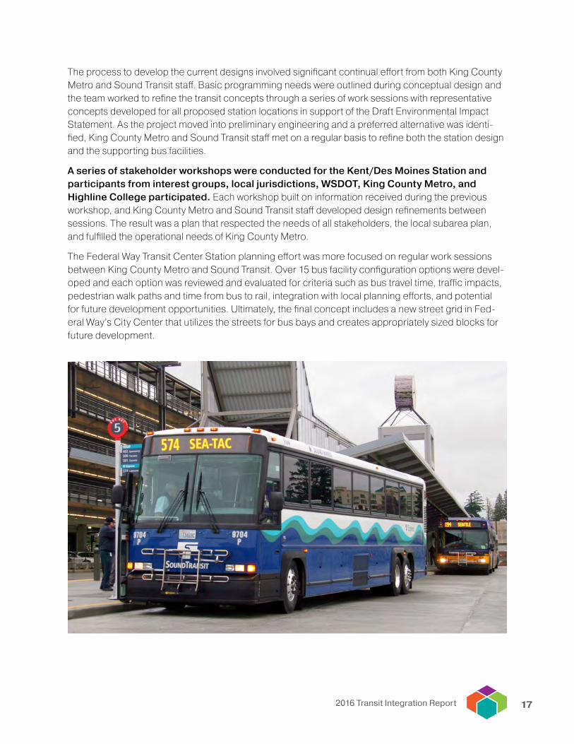
The process to develop the current designs involved significant continual effort from both King County Metro and Sound Transit staff. Basic programming needs were outlined during conceptual design and the team worked to refine the transit concepts through a series of work sessions with representative concepts developed for all proposed station locations in support of the Draft Environmental Impact Statement. As the project moved into preliminary engineering and a preferred alternative was identi-fied, King County Metro and Sound Transit staff met on a regular basis to refine both the station design and the supporting bus facilities.
A series of stakeholder workshops were conducted for the Kent/Des Moines Station and participants from interest groups, local jurisdictions, WSDOT, King County Metro, and Highline College participated. Each workshop built on information received during the previous workshop, and King County Metro and Sound Transit staff developed design refinements between sessions. The result was a plan that respected the needs of all stakeholders, the local subarea plan, and fulfilled the operational needs of King County Metro.
The Federal Way Transit Center Station planning effort was more focused on regular work sessions between King County Metro and Sound Transit. Over 15 bus facility configuration options were devel-oped and each option was reviewed and evaluated for criteria such as bus travel time, traffic impacts, pedestrian walk paths and time from bus to rail, integration with local planning efforts, and potential for future development opportunities. Ultimately, the final concept includes a new street grid in Fed-eral Way’s City Center that utilizes the streets for bus bays and creates appropriately sized blocks for future development.
2016 Transit Integration Report18
photo courtesy of Adam Lynn of the Tacoma News Tribune
Integrating other administrative functions and internal business processes
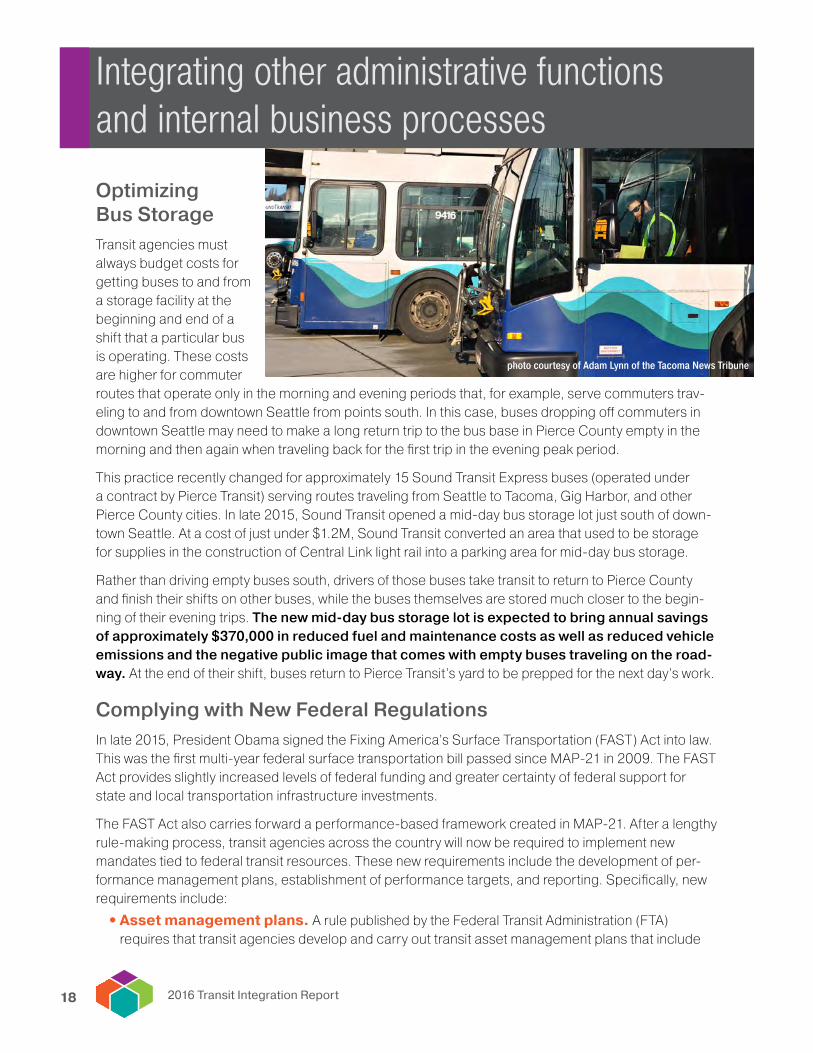
Optimizing Bus Storage Transit agencies must always budget costs for getting buses to and from a storage facility at the beginning and end of a shift that a particular bus is operating. These costs are higher for commuter routes that operate only in the morning and evening periods that, for example, serve commuters trav-eling to and from downtown Seattle from points south. In this case, buses dropping off commuters in downtown Seattle may need to make a long return trip to the bus base in Pierce County empty in the morning and then again when traveling back for the first trip in the evening peak period.
This practice recently changed for approximately 15 Sound Transit Express buses (operated under a contract by Pierce Transit) serving routes traveling from Seattle to Tacoma, Gig Harbor, and other Pierce County cities. In late 2015, Sound Transit opened a mid-day bus storage lot just south of down-town Seattle. At a cost of just under $1.2M, Sound Transit converted an area that used to be storage for supplies in the construction of Central Link light rail into a parking area for mid-day bus storage.
Rather than driving empty buses south, drivers of those buses take transit to return to Pierce County and finish their shifts on other buses, while the buses themselves are stored much closer to the begin-ning of their evening trips. The new mid-day bus storage lot is expected to bring annual savings of approximately $370,000 in reduced fuel and maintenance costs as well as reduced vehicle emissions and the negative public image that comes with empty buses traveling on the road-way. At the end of their shift, buses return to Pierce Transit’s yard to be prepped for the next day’s work.
Complying with New Federal RegulationsIn late 2015, President Obama signed the Fixing America’s Surface Transportation (FAST) Act into law. This was the first multi-year federal surface transportation bill passed since MAP-21 in 2009. The FAST Act provides slightly increased levels of federal funding and greater certainty of federal support for state and local transportation infrastructure investments.
The FAST Act also carries forward a performance-based framework created in MAP-21. After a lengthy rule-making process, transit agencies across the country will now be required to implement new mandates tied to federal transit resources. These new requirements include the development of per-formance management plans, establishment of performance targets, and reporting. Specifically, new requirements include:
• Asset management plans. A rule published by the Federal Transit Administration (FTA) requires that transit agencies develop and carry out transit asset management plans that include

192016 Transit Integration Report
an asset inventory, condition assessments for all inventoried assets, and a prioritized list of investments to improve the state of good repair of their capital assets. Transit asset management plans are due to FTA by October 1, 2018.
• Public transportation safety plans. Effective September 2016, FTA requires transit agencies to develop and implement public transportation agency safety plans that ensure these systems are safe. Public transportation agency safety plans are expected to be adopted by transit agencies no later than September 2017.
• Performance targets. Federal policy requires that targets be set at the agency, regional, and state levels to identify desired performance outcomes regarding transit asset management and safety. Regional transit asset management targets must be adopted in July 2017 and regional transit safety targets must be in adopted in March 2018.
As the deadlines indicate, the central Puget Sound’s transit agencies must all develop plans and tar-gets that ultimately comply with federal regulations. The region’s transit executives and general managers see this as an opportunity for collaboration, the incorporation of best practices both regionally and nationally, and for information and resource sharing during the target and plan development processes. The Puget Sound Regional Council and its Transportation Oper-ators Committee will be convening working groups to ensure coordinated and integrated target and plan development processes.
Working Together on Transit Vehicle PurchasesThe purchase of vehicles is a function undertaken by all transit agencies in the central Puget Sound and provides perhaps the easiest opportunity for coordination in a way that saves agencies — and therefore taxpayers — time and money. When transit agencies come together to purchase vehicles in one contract, they achieve economies of scale and are able to purchase at a lower per-vehicle cost, and also save time by managing only one procurement process rather than several.
There are three primary instruments by which transit agencies coordinate on cooperative procurements:
• Joint procurements occur when two or more agencies join together in a procurement partnership. Agencies that take part in a joint procurement develop specifications and evaluate proposers jointly, with one agency typically taking a lead role in administering the procurement process. A recent example in the region is the purchase of 143 dou-ble-decker buses for use by Sound Transit (32 buses, with an option to purchase 43 more at a later date), Community Transit (57 buses), and Kitsap Transit (11 buses).
Three transit agencies are jointly procuring double decker buses.
New federal regulations will increase the focus on keeping transit assets in a state of good repair.

2016 Transit Integration Report20
• Cooperative procurement (aka “piggybacking”) is when one agency joins a contract that was solicited and awarded by another agency. A typical occurrence of piggybacking is when a tran-sit agency acquires fewer vehicles than it had originally estimated for in the contract and another transit agency is able to use the excess capacity. Piggybacking typically requires less coordination than a joint procurement but produces the same benefits in time and money.
• Third-party aggregators are often referred to as consortium contracts or cooperative purchase agreements. Oftentimes, a large agency such as the Washington State Department of Transporta-tion will put together a contract solely for the purpose of allowing other municipalities to participate in, which is also referred to “buying off of the state contract.” An example in the region is when transit agencies purchase off a state contract for non-revenue fleet vehicles (e.g., trucks and other equipment), paratransit vans, and vanpool vehicles.
The obvious benefits of using these three options are the time and money agencies save by coordinat-ing their purchases. King County Metro recently used an Oregon State Department of Transportation contract to acquire more than 100 60 foot buses, which will allow the buses to be procured faster and support continued service growth in King County. These practices also allow transit agencies to better align fleet purchases and to purchase vehicle types that are preferred by transit riders, as evidenced by the growing shift to double-decker buses in parts of the region.

212016 Transit Integration Report
Integrating customer-focused tools and initiatives
Customer Call Center Integration in Snohomish CountySince last summer, transit riders seeking information about getting around Snohomish County only have to call one phone number. Beginning in August 2015, Community Transit took over the customer service call center function for all transit-related customer inquiries in Snohomish County. Before this change occurred, both Community Transit and Everett Tran-sit operated separate call centers.
Though the change only recently took place, it was several years in the making. Agency staff realized that as customers increasingly wanted to receive all their information needs together, it no longer made sense to provide customers one piece of information and then refer them to the other call center to answer their remaining questions.
Management at Everett Transit and Community Transit bought in to the approach and an agreement was developed for sharing costs based on the volume of calls received. Customers benefit by having all their questions answered in one call. Everett Transit was able to redeploy their dedicated call center staff person to complete other duties.
In addition to serving customer inquiries about Community Transit and Everett Transit, the call center also receives calls regarding Sound Transit service in Snohomish County. The call center also has information that allows for trips to be planned throughout the central Puget Sound region, including King and Pierce counties. Community Transit also processes calls for ORCA card-related issues for Community Transit, Everett Transit, and Sound Transit. And while the call center receives calls regard-ing complaints about Everett Transit, Everett Transit still controls the official complaint process so that they can handle those issues internally.
The ethos of Community Transit’s customer service call center is to give people the information they need. The value of creating an integrated customer call center in Snohomish County is in making this information as easy to get as possible.
Open Transit DataAccurate, reliable data is an increasingly important element of transit service in the central Puget Sound. Riders expect to be able to plan trips and check arrival times on the internet and on their mobile phones. Because of this, Sound Transit, in partnership with the other transit agencies in the region, created the Open Transit Data (OTD) initiative, a collaborative effort to create a platform of publicly accessible transit data for the Puget Sound region.
Application developers and transit agencies access this data and provide it to riders via web pages, mobile applications, dynamic signage, and other tools. By making the data available, agencies are also incentiv-ized to improve the overall data quality that exists, as well as to increase the types of data they supply.

2016 Transit Integration Report22
Members of the initiative include Sound Transit, King County Metro, Community Transit, Pierce Transit, Everett Transit, Seattle Streetcar, Washington State Ferries, Intercity Transit, and the shuttle services operated at Seattle Children’s Hospital and Joint Base Lewis-McChord.
Sound Transit and its partners launched the OTD initiative to provide a cen-tral location for application developers and agencies to access transit data. Application developers behind such products as OneBusAway, the Transit app, and the Moovit app are using this data to create tools that can quickly become indispensable to transit riders.
Since beginning to host data in 2013, transit agencies have committed to a continuous cycle in both the improvement of data quality and the expansion of types of data available. Improvements to the data hosted via the open tran-sit data portal anticipated by the end of the 2016 or early 2017 include:
• Real-time Link light rail and Sounder commuter rail data
• Real-time Community Transit data, which follows an intensive effort by Community Transit planners to ensure great data quality in advance of releasing it for public consumption
• Including additional participants in the OTD initiative
Beyond that, agencies are actively working to expand the types of data available in 2017 and beyond including information about bike rack availability on buses, information about bus and rail capacity, real-time information about available park and ride capacity, and incorporating real-time traffic information to provide better precision about transit arrival times.
Improved data availability won’t resolve all of the challenges inherent in the transit data ecosystem, most notably the fact that most systems were designed and built primarily for different purposes. As an example, the primary purpose of the system that provides the light rail vehicles’ data is to operate the rail system and the underlying fire, life, and safety systems, not necessarily to provide real-time infor-mation about its location. Similarly, agencies are resource constrained in tangible ways that limit the scope of some of these efforts. Finally, competition for skilled workers to develop public data is fierce; private sector companies can easily pay more for software developers, which reduces the labor pool available to the region’s transit agencies.
That said, however, the private sector adds tremendous value to the data available through the open transit data initiative by building the types of apps and products that quickly become indispensable to riders, all of which are built on data collected, processed, and maintained by the region’s transit agencies.
Coordinated Wayfinding StrategyPrevious transit integration reports have taken up the topic of wayfinding, which refers broadly to the various media by which customer information is communicated to transit riders and can include sig-nage, maps, software applications, and auditory messaging. Wayfinding is one transit integration area where most everyone can agree that improvements can be made, especially for tourists, recent arrivals to the region, or new users of the transit system.
The 2015 Transit Integration Report documented some of the reasons why wayfinding isn’t currently working as well as it can — particularly in downtown Seattle — including the fact that there are multiple
Transit agency data is the backbone for many applications available to riders.

232016 Transit Integration Report
wayfinding systems in place, some of which contain confusing and contradictory information. It also described why a solution isn’t simple, straightforward, or cheap — that even removing wayfinding ele-ments without a coordinated strategy, approach, and funding plan to replace them would not be of value to transit customers. Finally, the 2015 Transit Integration Report defined guiding principles for wayfinding and transit that, if adhered to, will make it easy for people to get around no matter their familiarity with the region or its transit systems.
The lack of a coordinated wayfinding strategy and system often means that people, and especially visitors and tourists, are less likely to explore walking routes on their own, including routes to bus and train sta-tions, routes between transit stations, and first- or last-mile journeys. Seniors and people with disabilities are the most affected, as these groups are generally less comfortable traveling for a longer period of time.
Since last year’s report, initial conversations have begun among potential agency and private sector partners to develop a coordinated strategy for wayfinding, first in downtown Seattle and potentially expanding from there to other regional transit hubs. The strategy would focus on developing an inte-grated wayfinding system that would create a uniform wayfinding language and improve the transit sys-tem’s usability as a whole. It would be developed to integrate with other transportation modes, so that people can quickly identify a route to their destination when they exit a downtown Seattle transit tunnel station, arrive at Colman Dock, or reach their bus stop.
A coordinated wayfinding strategy can translate to cost savings for individual agencies. The potential system could contain a shared mapping database, graphic design standards, and suggested planning tools. The system would be designed to be adaptable to the individual branding identity of each transit agency in the region while providing predictable and consistent wayfinding information to customers. The creation and implementation of a coordinated wayfinding system will improve the expe-rience for all users no matter their level of personal mobility or their familiarity with down-town Seattle, other key regional destinations, and the regional transit system.
The initial phase of the project will focus on established regional multimodal hubs (e.g., King Street Station, Colman Dock, and Westlake Station) in downtown Seattle. Such an integrated pedestrian and transit wayfinding system would improve the user experience, enhance coordination, boost local business districts, encourage walking and bicycling, and ultimately increase transit ridership. It would also allow local jurisdictions and neighborhoods to use the shared database and design to commis-sion consistent neighborhood and last mile wayfinding tools. Similar programs are already in place in London and New York City.
Downtown Seattle currently includes multiple wayfinding systems that aren’t consistent or integrated.

1011 Western Avenue, Suite 500 • Seattle, WA 98104-1035 • 206-464-7090 • psrc.orgPuget Sound Regional Council