Embed Size (px)
Citation preview
2015 PROCEDURES
GREATER BALTIMORE EXPOSED SOIL = POLLUTION SURVEYThe purpose of the Greater Baltimore Exposed Soil = Pollution (ES=P) Survey is to supportBaltimore City and the five surrounding counties - Anne Arundel, Baltimore, Carroll, Harford andHoward - in winning increased use of erosion control measures on construction sites. Generallyconstruction sites in these six jurisdictions make fair to good use of perimeter controls like black siltfence and ponds, but these measures only keep a third to half of the soil eroded on the site frombecoming offsite mud pollution. This is why State law requires the application of straw mulch, grassand other erosion control measures once the site reaches rough grade and mass earth-moving ends. By greatly reducing soil erosion these stabilization measures slash offsite mud pollution by 90% to99%. And it is only through stabilization of soil erosion that sediment losses can be reduced to thepoint where offsite pollution is prevented. Hence the phrase Exposed Soil = Pollution. Wheneveryou see exposed soil on a site then pollution is likely to result come the next major storm. Furtherbackground, including the damages caused by sediment and State legal requirements forstabilization, see the Greater Baltimore Survey 2014 report posted at: ceds.org/esp/ES=PReport.pdf
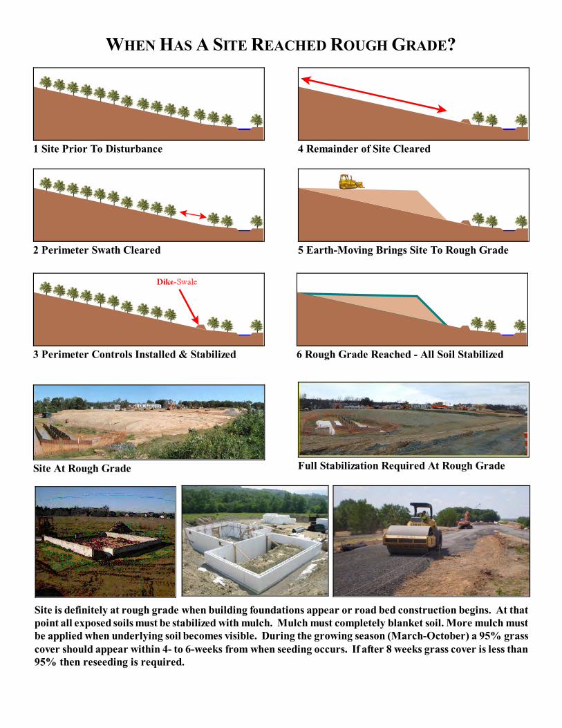
With regard to stabilization and minimizing mud pollution, there are four phases to the developmentof most sites. First, site development begins with clearing just the site perimeter where silt fence,ponds and other control measures are installed. Once installation is complete the contractor has threedays to get exposed soils on the perimeter stabilized with mulch or other measures. These soils mustalso be seeded with grass and a dense (95% coverage) growth should appear within four- to eight-weeks during the growing season (March - October). Mulch must be replaced whenever underlyingsoil becomes visible. Second, the interior of the site is cleared of vegetation, existing buildings, etc. Third, earth-moving equipment (bulldozers, graders, etc.) cut and fill until relatively level areas arecreated. Of course these level areas are where building will occur. This point is known as roughgrade. When building foundations appear or roads-parking lots are under construction, then that partof the site is at rough grade and all exposed soil must be stabilized within seven days. The fourthphase is final stabilization when remaining erodible soils are smoothed then permanently landscaped. Several illustrations follow these procedures. The illustrations give examples of all four phases plusthe other information requested on the survey form.
SURVEY PROCEDURES:1. If you live or work in the Greater Baltimore area, then please keep an eye out for active
construction sites. Sites can be anywhere but are usually concentrated along major roads. Sitesalso tend to congregate in a given area so check out Google Earth and other aerial photos tosee where sites were a year or two ago. You may well find new sites in those areas. Note thename and location of each site then add it our database at: ceds.org/sites
2. In late May we’ll schedule three survey dates for each of the six jurisdictions. We’ll base thedates upon the preference you and others from your jurisdiction selected when you registeredfor the survey. We’ll send you an email asking you to sign up for one or more surveys. We’ll
Page 1 of 4
keep taking names until we have five people signed up for a survey. Preference will be givento those who have not previously participated in a survey.
3. On the day of the survey we’ll meet at a central location such as a park and ride lot. Of courseyou’ll receive an email letting you know where and when to meet your survey team. You willreceive a clipboard with Survey Forms, a blue pen (always use blue), a list of sites giving theID for each, and a copy of these procedures.
4. The first construction we visit will be a simple one. There we will walk you through thefollowing procedures for completing the ES=P Survey Form. As with all sites we visit we’llpark on a public area where we can get the best view of the site. We need not see the entiresite, just a representative portion.
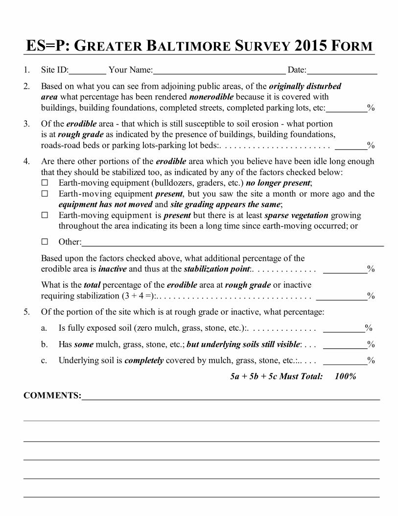
5. At each site you’ll be asked to complete a survey form using the blue pen provided. You’llfind a sample form at the end of these procedures. The team leader will provide the Site IDwhich you’ll print on your form along with your first and last name and the date (e.g. 6-7-15). The team leader will also ask each participant for their answer to each question on the form. If the numbers ranged widely then each team member will explain how they arrived at theiranswer. We’ll then seek to reach agreement on a number. But you will be free to enter anothernumber if you disagree with the team.
6. First you’ll be asked to define the Site or the originally disturbed area. Of course this is thearea where vegetation or existing buildings were cleared. This is usually easy to define bylooking for the edge of recently cleared forest, the outermost perimeter silt fence, etc. Theoriginally disturbed area will then be designated the Site. See the first illustration followingthese instructions.
7. Next we’ll ask each team member to estimate what percentage of the Site is nonerodiblebecause it is covered by buildings, paved road or parking lots, a paved sidewalk, permanentlystabilized, etc. See the second illustration following these instructions.
8. The remaining percentage of the Site is then the erodible area and consists of:a. areas blanketed by vegetation or exposed soil; b. exposed soil covered partially or completely with straw mulch or gras; orc. it could be a road bed or parking lot bed covered with stone to prevent erosion. All these areas are considered erodible because they are or could become susceptible to erosionif vegetation is cleared, mulch blows away, grass dies, or stone washes away.
9. Now, of the erodible area estimate the percentage which is at rough grade as indicated by thepresence of buildings, building foundations, roads-road beds or parking lots-parking lot beds. Again, construction of these features can only begin when a portion or all of a site reachesrough grade. So, if they are present then that portion of the site is at rough grade. See the thirdillustration following these instructions.
Page 2 of 4
10. On large sites the entirety may be cleared then left inactive while construction begins on a verysmall portion. The inactive area must be stabilized with at least straw mulch if it will be weeksbefore earth-moving will again take place in that area. The survey form lists the followingindicators that portions of a site have been inactive long enough to trigger the need forstabilization:a. Earth-moving equipment (bulldozers, graders, etc.) no longer present;b. Earth-moving equipment present, but you saw the site a month or more ago and the
equipment has not moved and site grading appears the same; and/orc. Earth-moving equipment is present but there is at least sparse vegetation growing
throughout the area indicating its been a long time since earth-moving occurred.
11. Based on the factors given in step 10, estimate what percentage of the erodible area is inactiveand thus at the stabilization point.
12. Next, compute the total percentage of the erodible area at rough grade or inactive which requires stabilization.
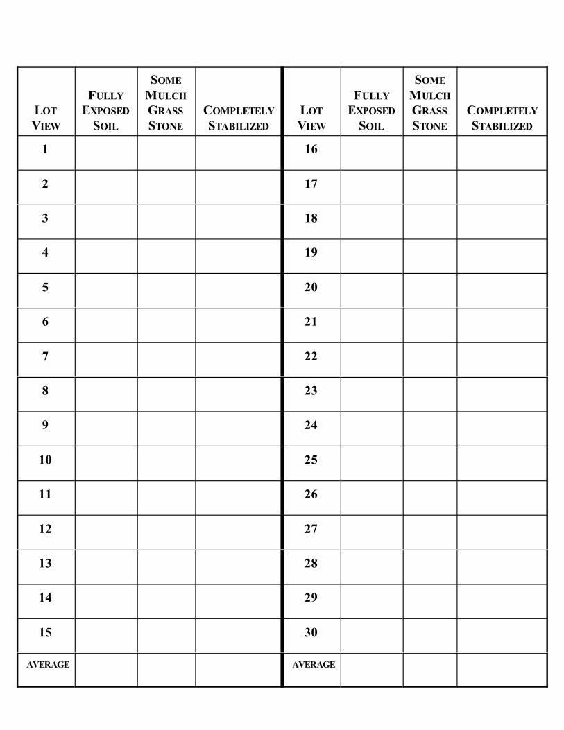
13. Finally, of the portion of the site which requires stabilization (areas at rough grade plusinactive) what percentage:a. Is fully exposed soil (zero mulch, grass, stone, etc);b. Has some mulch, grass, stone, etc.; but underlying soils still visible; andc. Underlying soil is completely covered by mulch, grass, stone, etc.The answers to a, b and c must total 100%.
14. On many residential projects you’ll find numerous lots where construction is complete andthe adjoining area permanently stabilized. Interspersed with these lots are those whereconstruction is ongoing with erodible areas remaining. Coming up with an average answerto Question #13 for each of the three percentages can be challenging. But the table on theback of this form will ease this task.
As you drive through a representative portion of the site, focus on the lots whereconstruction is ongoing and permanent stabilization has not occurred. For each of theseincomplete lots note the appropriate percentage on the table. Once all developing lots havebeen surveyed, total the percentages and divide by the number of lots to get an average.
On other sites you’ll find few lots but large variations as you drive construction roads. Asyou travel down a road take in a view and estimate the Question #13 percentages. Take inthe next view and make another notation. Continue until you’ve looked at either the entiresite or a representative portion. Finish by computing the average for the three percentages.
15. Add any comments you wish at the bottom of the form.
Page 3 of 4

16. The Team Leader will collect your forms at the end of the survey. Later your forms will bescanned and emailed back to you.
17. When all the surveys are completed we’ll compile a draft report and request your commentson the draft. We’d like to list you as one of the volunteers who participated in the survey, butit’s OK to be anonymous too. Just make certain we know this is your wish. The 2014 repoortcan be downloaded at: ceds.org/esp/ES=PReport.pdf
If you have any questions contact Richard Klein at 410-654-3021 or [email protected]. For furtherdetail on ES=P visit: ceds.org/esp
Page 4 of 4
ES=P: GREATER BALTIMORE SURVEY 2015 FORM
1. Site ID: Your Name: Date:
2. Based on what you can see from adjoining public areas, of the originally disturbed area what percentage has been rendered nonerodible because it is covered with buildings, building foundations, completed streets, completed parking lots, etc: %
3. Of the erodible area - that which is still susceptible to soil erosion - what portion is at rough grade as indicated by the presence of buildings, building foundations, roads-road beds or parking lots-parking lot beds:. . . . . . . . . . . . . . . . . . . . . . . . %
4. Are there other portions of the erodible area which you believe have been idle long enoughthat they should be stabilized too, as indicated by any of the factors checked below:G Earth-moving equipment (bulldozers, graders, etc.) no longer present;G Earth-moving equipment present, but you saw the site a month or more ago and the
equipment has not moved and site grading appears the same; G Earth-moving equipment is present but there is at least sparse vegetation growing
throughout the area indicating its been a long time since earth-moving occurred; or
G Other:
Based upon the factors checked above, what additional percentage of theerodible area is inactive and thus at the stabilization point:. . . . . . . . . . . . . . %
What is the total percentage of the erodible area at rough grade or inactive requiring stabilization (3 + 4 =):. . . . . . . . . . . . . . . . . . . . . . . . . . . . . . . . . . %
5. Of the portion of the site which is at rough grade or inactive, what percentage:
a. Is fully exposed soil (zero mulch, grass, stone, etc.):. . . . . . . . . . . . . . . %
b. Has some mulch, grass, stone, etc.; but underlying soils still visible: . . . %
c. Underlying soil is completely covered by mulch, grass, stone, etc.:.. . . . %
5a + 5b + 5c Must Total: 100%
COMMENTS:
LOT
VIEW
FULLY
EXPOSED
SOIL
SOME
MULCH
GRASS
STONE
COMPLETELY
STABILIZED
LOT
VIEW
FULLY
EXPOSED
SOIL
SOME
MULCH
GRASS
STONE
COMPLETELY
STABILIZED
1 16
2 17
3 18
4 19
5 20
6 21
7 22
8 23
9 24
10 25
11 26
12 27
13 28
14 29
15 30
AVERAGE AVERAGE
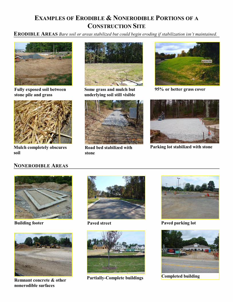
95% or better grass coverFully exposed soil betweenstone pile and grass
Some grass and mulch butunderlying soil still visible
Mulch completely obscuressoil
Road bed stabilized withstone
Parking lot stabilized with stone
Building footer Paved street Paved parking lot
Completed buildingPartially-Complete buildingsRemnant concrete & othernonerodible surfaces
EXAMPLES OF ERODIBLE & NONERODIBLE PORTIONS OF A
CONSTRUCTION SITE
ERODIBLE AREAS Bare soil or areas stabilized but could begin eroding if stabilization isn’t maintained.
NONERODIBLE AREAS
1 Site Prior To Disturbance 4 Remainder of Site Cleared
3 Perimeter Controls Installed & Stabilized
2 Perimeter Swath Cleared 5 Earth-Moving Brings Site To Rough Grade
6 Rough Grade Reached - All Soil Stabilized
Full Stabilization Required At Rough GradeSite At Rough Grade
WHEN HAS A SITE REACHED ROUGH GRADE?
Site is definitely at rough grade when building foundations appear or road bed construction begins. At thatpoint all exposed soils must be stabilized with mulch. Mulch must completely blanket soil. More mulch mustbe applied when underlying soil becomes visible. During the growing season (March-October) a 95% grasscover should appear within 4- to 6-weeks from when seeding occurs. If after 8 weeks grass cover is less than95% then reseeding is required.
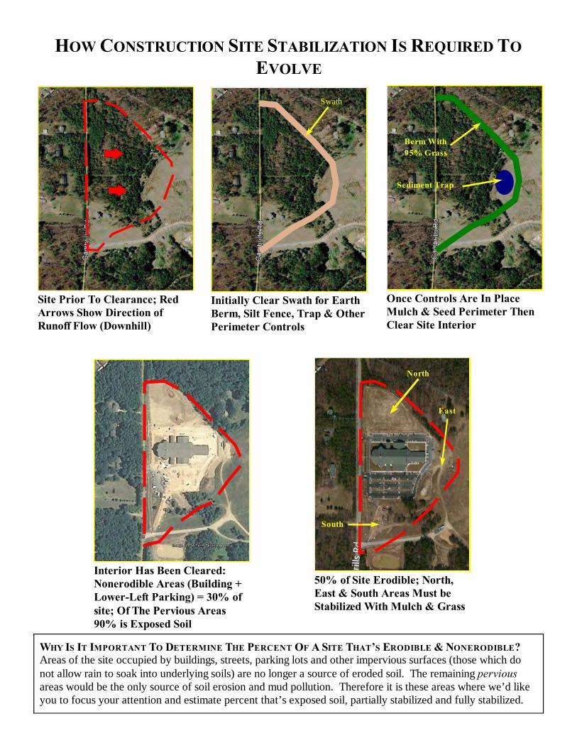
Once Controls Are In PlaceMulch & Seed Perimeter ThenClear Site Interior
WHY IS IT IMPORTANT TO DETERMINE THE PERCENT OF A SITE THAT’S ERODIBLE & NONERODIBLE?Areas of the site occupied by buildings, streets, parking lots and other impervious surfaces (those which donot allow rain to soak into underlying soils) are no longer a source of eroded soil. The remaining perviousareas would be the only source of soil erosion and mud pollution. Therefore it is these areas where we’d likeyou to focus your attention and estimate percent that’s exposed soil, partially stabilized and fully stabilized.
Site Prior To Clearance; RedArrows Show Direction ofRunoff Flow (Downhill)
Initially Clear Swath for EarthBerm, Silt Fence, Trap & OtherPerimeter Controls
50% of Site Erodible; North,East & South Areas Must beStabilized With Mulch & Grass
Interior Has Been Cleared:Nonerodible Areas (Building +Lower-Left Parking) = 30% ofsite; Of The Pervious Areas90% is Exposed Soil
North
East
South
HOW CONSTRUCTION SITE STABILIZATION IS REQUIRED TO
EVOLVE
Swath
Berm With
95% Grass
Sediment Trap
Perimeter Sediment TrapSilt Fence & Earth BermPerimeter Silt Fence Rows
When the perimeter controls were installed & stabilized thecontractor was then allowed to clear the interior (upper portion)of the site. Here you see perimeter stabilization with dense mulch
plus grass approaching 95% coverage.Perimeter Earth Berm With 95%Grass Cover
About 95% Vegetative CoverAbout 75% Vegetative Cover
³ Good Stabilization
Straw mulch completely
blankets underlying soil
from view.
Poor Stabilization º
Soil still visible through
the sparse grass and
mulch.
About 30% Vegetative Cover
PERIMETER CONTROLS & PERIMETER STABILIZATION