Embed Size (px)
Citation preview
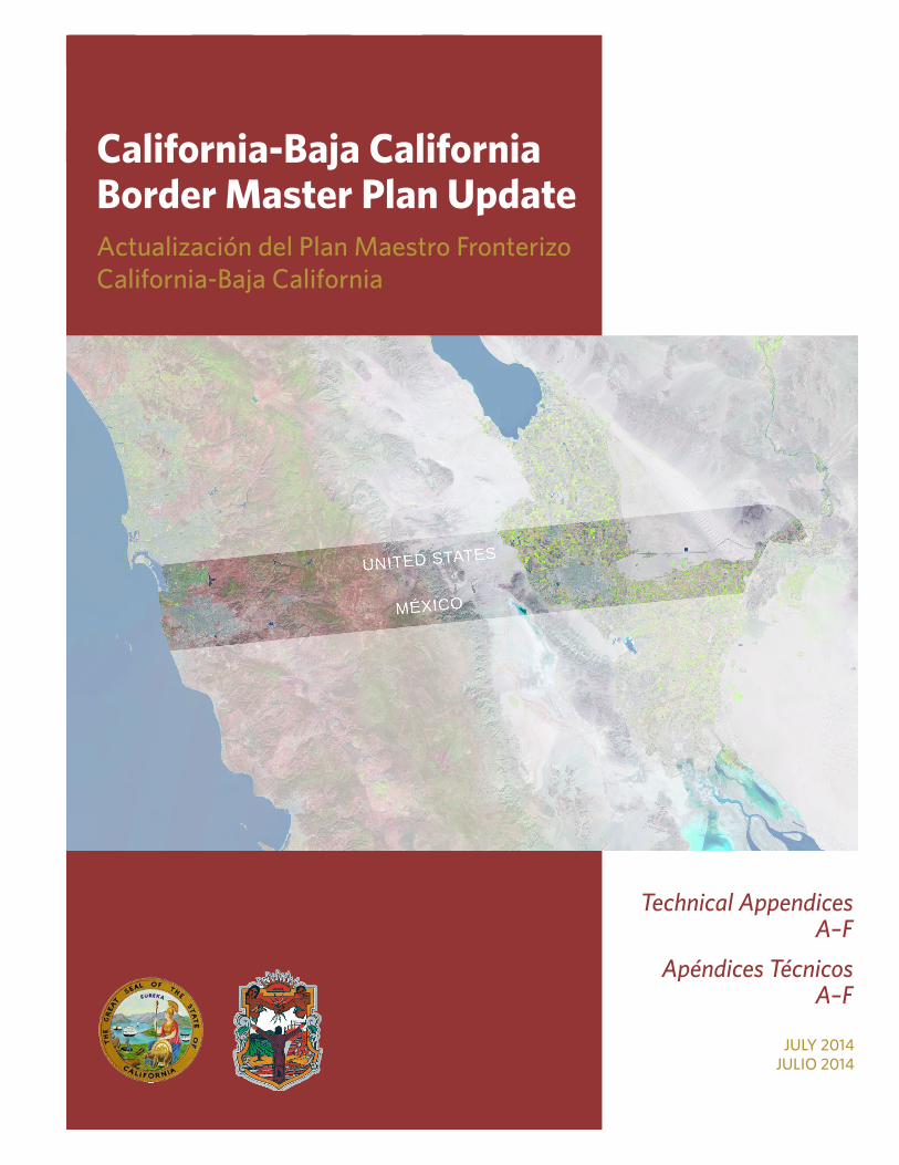
2014California-Baja California Border Master Plan UpdateActualización del Plan Maestro Fronterizo California-Baja California
Technical Appendices A–F
Apéndices Técnicos A–F
JULY 2014JULIO 2014

This page intentionally left blank

Technical Appendices A - F i
CALIFORNIA-BAJA CALIFORNIA 2014 BORDER MASTER PLAN UPDATE LIST OF APPENDICES
A Project-Specific Documentation ................................................................................................ 1 A-1 BMP Charter .................................................................................................................................. 3 A-2 BMP Representatives Contact List ............................................................................................... 9 A-3 Schedule of Meetings .................................................................................................................... 31 A-4 Policy Advisory Committee Meeting Agreements and Approvals ................................................. 33 A-5 Policy Advisory Committee Meetings: Attendance........................................................................ 61 A-6 Technical Working Group Meeting Agreements ........................................................................... 69 A-7 Technical Working Group Meetings: Attendance .......................................................................... 81 A-8 Transportation Modeling Focus Group (January 18, 2012) .......................................................... 89 A-9 Transportation Modeling Cube Model Overview (February 28, 2012) ......................................... 95 A-10 Transportation Modeling Peer Exchange (June 27, 2012) .......................................................... 101 A-11 Funding Peer Exchange (October 24, 2013) ................................................................................ 121 A-12 BMP Acknowledgements – Other than PAC and TWG ................................................................ 161 A-13 Comments and Responses on Draft Report ................................................................................. 165 B Survey of BMP Agencies—Scope of Work ............................................................................... 171 B-1 Survey Results Summary .............................................................................................................. 173 B-2 Survey Results Packet .................................................................................................................. 183 C Border Crossing and Border Wait Time Data ........................................................................... 295 C-1 Northbound Border Crossing Data ................................................................................................ 297 C-2 Northbound Border Wait Time Data .............................................................................................. 305 D Online Data Management Portal User Guide ............................................................................ 307 D-1 User Guide (English) ..................................................................................................................... 309 D-2 User Guide (Spanish) .................................................................................................................... 347 E Bicycle Classification Systems ................................................................................................. 389 F Evaluation Criteria and Ranked Lists of Projects .................................................................... 397 F-1 Evaluation Criteria (POE and Transportation) .............................................................................. 399 F-2 New POE Project Rankings .......................................................................................................... 429 F-3 Modernization of Existing POE Project Rankings ......................................................................... 431 F-4 U.S. Highway Project Rankings .................................................................................................... 435 F-5 U.S. Arterial Project Rankings ....................................................................................................... 439

ii Technical Appendices A - F
F-6 U.S. Interchange Project Rankings ............................................................................................... 445 F-7 U.S. Rail/Transit Project Rankings ................................................................................................ 447 F-8 Mexico Arterial Project Rankings .................................................................................................. 449 F-9 Mexico Interchange Project Rankings .......................................................................................... 451 F-10 Mexico Rail/Transit Project Rankings ........................................................................................... 453 F-11 Expanded List of Ranked Projects ................................................................................................ 455 F-12 Project Number Generation .......................................................................................................... 461 G Scoring Sheets for Ranked Projects (Under Separate Cover)
H Projects Not Ranked (Under Separate Cover)

Appendix A: Project Specific Documentation


APPENDIX A-1: BMP Charter
California-Baja California 2014 Border Master Plan Update Policy Advisory Committee and Technical Working Group Charter
Revisions to the 2008 Border Master Plan Charter
PURPOSE
Under the direction of the U.S. / Mexico Joint Working Committee, the California Department of Transportation (Caltrans) and the State of Baja California’s Secretariat of Infrastructure and Urban Development (SIDUE) hereby re-establish the California-Baja California Border Master Plan Policy Advisory Committee and Technical Working Group. These groups will participate in the development of an update to the 2008 Border Master Plan. LINE OF REPORTING
No change. RESPONSIBILITIES The Policy Advisory Committee will be responsible for approving the scope of work and for providing direction throughout the study. MEMBERSHIP
In addition to the agencies listed in the 2008 BMP, the following are new agencies or revisions to agency names.
United States • City of El Centro • City of Holtville • City of Imperial Beach • City of National City • Imperial County Transportation Commission (ICTC) Imperial Valley Association of Governments
(IVAG) [IVAG no longer exists]
Mexico • Consulate General of Mexico in San Diego (Consulado de México en San Diego) • Office of the Governor of Baja California (Oficina del Gobernador del Estado de Baja California) • Municipality of Mexicali (Municipio de Mexicali) including Municipal Planning Institute of Mexicali
(Instituto Municipal de Planeación de Mexicali, IMIP) • Municipality of Playas de Rosarito (Municipio de Playas de Rosarito) including Planning Institute of
Playas de Rosarito (Instituto Municipal de Planeación de Playas de Rosarito, IMIP) • Municipality of Tecate (Municipio de Tecate) including Directorate of Urban Planning (Dirección de
Administración Urbana) • Municipality of Tijuana (Municipio de Tijuana) including Metropolitan Planning Institute of Tijuana
(Instituto Metropolitano de Planeación de Tijuana, IMPLAN)
3

APPENDIX A-1: BMP Charter
MEETING TIME AND LOCATION
The term of the project will be determined in the scope of work. Meeting locations and times will be established at each meeting for the next meeting. SELECTION OF THE CHAIR No change. DURATION OF EXISTENCE
The California-Baja California Border Master Plan Policy Advisory Committee and Technical Working Group will exist until the termination of the 2011/12 Border Master Plan Update.
4
APPENDIX A-1: BMP Charter
California-Baja California Border Master Plan Policy Advisory Committee and Technical Working Group Charter
2008 Border Master Plan
PURPOSE
Under the direction of the U.S. / Mexico Joint Working Committee, the California Department of Transportation (Caltrans) and the State of Baja California’s Secretariat of Infrastructure and Urban Development (SIDUE) hereby establish the California-Baja California Border Master Plan Policy Advisory Committee and Technical Working Group. These groups will participate in the development of a Border Master Plan—a comprehensive approach for coordinating planning and delivery of Port of Entry (POE) and transportation infrastructure projects serving POEs in the California-Baja California region. Ideally the approach and methodologies identified in the Border Master Plan would be incorporated into the respective planning and programming processes of the individual participating agencies at the federal, state, regional, and local levels in the U.S. and Mexico. LINE OF REPORTING
The Policy Advisory Committee and the Technical Working Group will report to Caltrans and SIDUE for the development of the California-Baja California Border Master Plan. Caltrans and SIDUE, in turn, report to the U.S. / Mexico Joint Working Committee for this project. RESPONSIBILITIES The Policy Advisory Committee will be responsible for providing direction, approving the study parameters, and establishing criteria for future evaluation of projects. Proposed objectives of Policy Advisory Committee are outlined below: • Establish clear parameters for the Border Master Plan such as defining the “Border Region” for the
purposes of this study, as well as the time horizon for data analysis and other issues needing definition as requested by the Technical Working Group.
• Ensure that the Border Master Plan goals are comprehensive and consistent with all stakeholder plans and strategies.
• Review and approve criteria for prioritizing improvements to existing or new POEs and connecting roads within the border region in future efforts.
• Seek to incorporate the study’s findings and methodologies into their agencies’ own planning and programming processes and into appropriate transportation and POE planning and funding documents.
• Commit resources and staff to the effort to ensure the timely exchange of information and data needed to successfully complete the study.
• Facilitate the exchange of information for ongoing and future planning and implementation activities.
• Participate in future Master Plan updates and/or other study recommendations as approved by the Policy Advisory Committee.
5

APPENDIX A-1: BMP Charter
The Technical Working Group will be responsible for supporting the Consultant to implement the direction of the Policy Advisory Committee by providing requested information in a timely manner, and for making recommendations to the Policy Advisory Committee. Some of the proposed objectives of the Technical Working Group are outlined below: • Assist in plan development process by providing the Consultant data and information requested on a
timely schedule.
• Review transportation and POE infrastructure assessments, proposals, and other pertinent information as requested by the Consultant.
• Endorse and forward to the Policy Advisory Committee criteria developed by the Consultant to prioritize improvements to existing or new POEs as well as connecting roads within a bi-state framework in future studies.
• Make recommendations to the Policy Advisory Committee and serve as a resource to the Consultant to maximize the opportunities to successfully complete this study.
MEMBERSHIP
The agencies listed below have been invited to participate in the Border Master Plan Policy Advisory Committee. Each agency will be asked to designate executive level managers to serve on the Policy Advisory Committee. Each agency will also designate senior staff to serve on the Technical Working Group. United States • U.S. Department of State (DOS) • U.S. Customs and Border Protection (CBP) • U.S. General Services Administration (GSA) • U.S. Federal Highway Administration (FHWA) • California Department of Transportation (Caltrans) • County of San Diego • City of San Diego • County of Imperial • City of Calexico • Imperial Valley Association of Governments (IVAG) • Southern California Association of Governments (SCAG) • San Diego Association of Governments (SANDAG)
6
APPENDIX A-1: BMP Charter
Mexico • Secretariat of Foreign Relations (Secretaría de Relaciones Exteriores, SRE) • Secretariat of Communications and Transportation (Secretaría de Comunicaciones y Transportes, SCT) • General Customs Administration (Administración General de Aduanas) • Secretariat of Social Development (Secretaría de Desarrollo Social, SEDESOL) • Institute of Administration and Estimates of National Real Estate (Instituto de Administración y
Avalúos de Bienes Nacionales, INDAABIN) • Secretariat of Infrastructure and Urban Development of Baja California (Secretaría de Infraestructura
y Desarrollo Urbano del Estado, SIDUE) • Municipal Planning Institute of Tijuana (Instituto Municipal de Planeación de Tijuana, IMPLAN) • Municipal Planning Institute of Mexicali (Instituto Municipal de Planeación de Mexicali, IMIP) • Municipality of Tecate (Municipio de Tecate) Other agencies may be invited to participate on specific tasks as work progresses. MEETING TIME AND LOCATION It is anticipated the Policy Advisory Committee and the Technical Working Group will hold six meetings each. The term of the project is from October 2006 through March 2008. Meeting locations will alternate between California and Baja California. SELECTION OF THE CHAIR
Executive level staff from Caltrans and SIDUE will serve as co-chairs on the Policy Advisory Committee. Senior level staff from Caltrans and SIDUE will serve as co-chairs on the Technical Working Group. DURATION OF EXISTENCE
The California-Baja California Border Master Plan Policy Advisory Committee and Technical Working Group will exist until the termination of the Border Master Plan study.
7

This page intentionally left blank
APPENDIX A-2: BMP Representatives Contact List
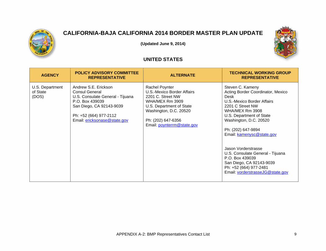
CALIFORNIA-BAJA CALIFORNIA 2014 BORDER MASTER PLAN UPDATE
(Updated June 9, 2014)
UNITED STATES
AGENCY POLICY ADVISORY COMMITTEE REPRESENTATIVE ALTERNATE TECHNICAL WORKING GROUP
REPRESENTATIVE
U.S. Department of State (DOS)
Andrew S.E. Erickson Consul General U.S. Consulate General - Tijuana P.O. Box 439039 San Diego, CA 92143-9039 Ph: +52 (664) 977-2112 Email: [email protected]
Rachel Poynter U.S.-Mexico Border Affairs 2201 C. Street NW WHA/MEX Rm 3909 U.S. Department of State Washington, D.C. 20520 Ph: (202) 647-6356 Email: [email protected]
Steven C. Kameny Acting Border Coordinator, Mexico Desk U.S.-Mexico Border Affairs 2201 C Street NW WHA/MEX Rm 3908 U.S. Department of State Washington, D.C. 20520 Ph: (202) 647-9894 Email: [email protected] Jason Vorderstrasse U.S. Consulate General - Tijuana P.O. Box 439039 San Diego, CA 92143-9039 Ph: +52 (664) 977-2481 Email: [email protected]
9

APPENDIX A-2: BMP Representatives Contact List
UNITED STATES
AGENCY POLICY ADVISORY COMMITTEE REPRESENTATIVE ALTERNATE TECHNICAL WORKING GROUP
REPRESENTATIVE
Customs and Border Protection (CBP)
Pete Flores Field Operations Director Customs and Border Protection 610 W. Ash Street Suite 1200 San Diego, CA 92101 Ph: (619) 652-9966 X 222 Fax: (619) 645-6644 Email: [email protected]
Andy Brinton Assistant Director, Field Operations (Mission Support) Office of Field Operations, San Diego Field Office US Customs and Border Protection 610 W. Ash Street, Suite 1200 San Diego, CA 92101 Ph: (619) 652-9966 x141 Fax: (619) 645-6644 Cell: (619) 619-520-3046 Email: [email protected]
Andy Brinton Assistant Director, Field Operations (Mission Support) Office of Field Operations, San Diego Field Office US Customs and Border Protection 610 W. Ash Street, Suite 1200 San Diego, CA 92101 Ph: (619) 652-9966 x141 Fax: (619) 645-6644 Cell: (619) 619-520-3046 Email: [email protected] Mikhail Pavlov Project Managment Analyst Planning and Program Development Branch US Customs and Border Protection 1717 H Street NW, Suite 800 Washington, DC 20006 Ph: (202) 325-7015 Email: [email protected]
10

APPENDIX A-2: BMP Representatives Contact List
UNITED STATES
AGENCY POLICY ADVISORY COMMITTEE REPRESENTATIVE ALTERNATE TECHNICAL WORKING GROUP
REPRESENTATIVE
Federal Highway Administration (FHWA)
Sylvia Grijalva US/Mexico Border Planning Coordinator Federal Highway Administration Office of Planning 4000 North Central Avenue Suite 1500 Phoenix, Arizona 85012 Ph: (602) 510-7986 Fax: Email: [email protected]
Richard E. Backlund Associate Division Administrator Federal Highway Administration California Division United States Department of Transportation Cal South Office 888 South Figueroa Street, Ste. 750 Los Angeles, CA 90017 Ph: (213) 894-4560 Fax: (213) 894-6185 Email: [email protected]
Richard E. Backlund Associate Division Administrator Federal Highway Administration California Division United States Department of Transportation Cal South Office 888 South Figueroa Street, Ste. 750 Los Angeles, CA 90017 Ph: (213) 894-4560 Fax: (213) 894-6185 Email: [email protected]
11
APPENDIX A-2: BMP Representatives Contact List
UNITED STATES
AGENCY POLICY ADVISORY COMMITTEE REPRESENTATIVE ALTERNATE TECHNICAL WORKING GROUP
REPRESENTATIVE
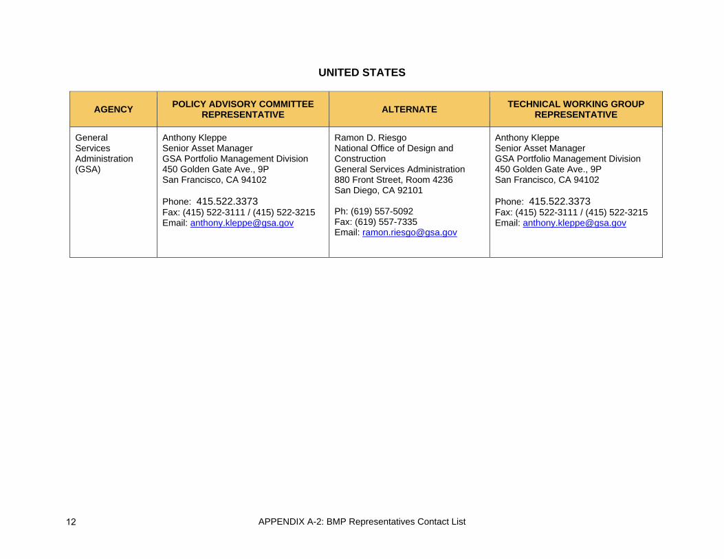
General Services Administration (GSA)
Anthony Kleppe Senior Asset Manager GSA Portfolio Management Division 450 Golden Gate Ave., 9P San Francisco, CA 94102 Phone: 415.522.3373 Fax: (415) 522-3111 / (415) 522-3215 Email: [email protected]
Ramon D. Riesgo National Office of Design and Construction General Services Administration 880 Front Street, Room 4236 San Diego, CA 92101 Ph: (619) 557-5092 Fax: (619) 557-7335 Email: [email protected]
Anthony Kleppe Senior Asset Manager GSA Portfolio Management Division 450 Golden Gate Ave., 9P San Francisco, CA 94102 Phone: 415.522.3373 Fax: (415) 522-3111 / (415) 522-3215 Email: [email protected]
12

APPENDIX A-2: BMP Representatives Contact List
UNITED STATES
AGENCY POLICY ADVISORY COMMITTEE REPRESENTATIVE ALTERNATE TECHNICAL WORKING GROUP
REPRESENTATIVE
California Department of Transportation (Caltrans)
Laurie Berman Director Caltrans District 11 4050 Taylor Street San Diego, CA 92110 Ph: (619) 688-6668 Fax: (619) 688-3122 Email: [email protected]
Bill Figge Deputy District Director Caltrans District 11 4050 Taylor Street San Diego, CA 92110 Ph: (619) 688-6681 Fax: (619) 688-2511 Email: [email protected]
Sergio Pallares International Border Studies Chief Caltrans District 11 4050 Taylor Street San Diego, CA 92110 Ph: (619) 688-3610 Fax: (619) 688-2511 Email: [email protected]
Imperial County Transportation Commission (ICTC)
Mark Baza Executive Director Imperial County Transportation Commission (ICTC) 1405 North Imperial Ave Ste. 1 El Centro, CA 92243 Ph: (760) 592-4494x201 Fax: (760) 592-4497 Cell: (760) 604-5508 Email: [email protected]
Virginia Mendoza Regional Transportation Planner Imperial County Transportation Commission (ICTC) 1405 North Imperial Ave Ste. 1 El Centro, CA 92243 Ph: (760) 592-4494x203 Fax: (760) 592-4497 Cell: (760) 604-3605 Email: [email protected]
Virginia Mendoza Regional Transportation Planner Imperial County Transportation Commission (ICTC) 1405 North Imperial Ave Ste. 1 El Centro, CA 92243 Ph: (760) 592-4494x201 Fax: (760) 592-4497 Cell: (760) 604-5508 Email: [email protected]
13

APPENDIX A-2: BMP Representatives Contact List
UNITED STATES
AGENCY POLICY ADVISORY COMMITTEE REPRESENTATIVE ALTERNATE TECHNICAL WORKING GROUP
REPRESENTATIVE
San Diego Association of Governments (SANDAG)
Gary Gallegos Executive Director SANDAG 401 B Street, Suite 800 San Diego, CA 92101 Ph: (619) 699-1900 Fax: (619) 699-1905 Email: [email protected]
Muggs Stoll Director of Land Use and Transportation Planning Department SANDAG 401 B Street, Suite 800 San Diego, CA 92101 Ph: (619) 699-1900 Fax: (619) 699-1905 Email: [email protected]
Rachel Kennedy Senior Transportation Planner SANDAG 401 B Street, Suite 800 San Diego, CA 92101 Ph: (619) 699-1929 Fax: (619) 699-1905 Email: [email protected]
Southern California Association of Governments (SCAG)
Annie Nam Manager, Goods Movement and Transportation Finance Southern California Association of Governments (SCAG) 818 W. Seventh Street, 12th Floor Los Angeles, CA 90017 Ph: (213) 236-1827 Fax: (213) 236-1963 Email: [email protected]
Mike Jones Senior Regional Planner Southern California Association of Governments (SCAG) 818 W. Seventh Street, 12th Floor Los Angeles, CA 90017 Ph: (213) 236-1978 Fax: (213) 236-1963 Email: [email protected]
Mike Jones Senior Regional Planner Southern California Association of Governments (SCAG) 818 W. Seventh Street, 12th Floor Los Angeles, CA 90017 Ph: (213) 236-1978 Fax: (213) 236-1963 Email: [email protected] Rajeev Seetharam Senior Regional Planner 818 W. Seventh Street, 12th Floor Los Angeles, CA 90017 Ph: (213) 236-1864 Fax: (213) 236-1963 Email: [email protected]
14

APPENDIX A-2: BMP Representatives Contact List
UNITED STATES
AGENCY POLICY ADVISORY COMMITTEE REPRESENTATIVE ALTERNATE TECHNICAL WORKING GROUP
REPRESENTATIVE
County of Imperial Rosa Lopez Solis Administrative Analyst County of Imperial 940 W. Main #208 El Centro, CA 92243 Ph: (760) 482-4677 Fax: (760) 352-7876 Email: [email protected]
Bill Brunet Public Works Director County of Imperial 940 W. Main #208 El Centro, CA 92243 Ph: (760) 482-4462 Fax: (760) Email: [email protected]
John Gay Public Works Deputy Director County of Imperial 940 W. Main #208 El Centro, CA 92243 Ph: (760) 482-4462 Fax: (760) Email: [email protected]
City of Calexico Oscar Rodriquez City Manager City of Calexico 608 Heber Avenue Calexico, CA 92231 Ph: (760) 768-2110 Fax: Email: [email protected]
Nick Servin Director of Public Works/City Engineer City of Calexico 608 Heber Avenue Calexico, CA 92231 Ph: (760) 768-7462 Fax: (760) 768-0854 Email: [email protected]
Nick Servin Director of Public Works/City Engineer City of Calexico 608 Heber Avenue Calexico, CA 92231 Ph: (760) 768-7462 Fax: (760) 768-0854 Email: [email protected]
15

APPENDIX A-2: BMP Representatives Contact List
UNITED STATES
AGENCY POLICY ADVISORY COMMITTEE REPRESENTATIVE ALTERNATE TECHNICAL WORKING GROUP
REPRESENTATIVE
City of El Centro Ruben Duran City Manager City of El Centro 1275 W. Main Street El Centro, CA 92243 Ph: (760) 337-4540 Fax: (760) 352-6177 Email: [email protected]
Abraham Campos Senior Engineer City of El Centro 1275 W. Main Street El Centro, CA 92243 Ph: (760) 337-5182 Fax: (760) Email: [email protected]
Abraham Campos Senior Engineer City of El Centro 1275 W. Main Street El Centro, CA 92243 Ph: (760) 336-8520 Fax: (760) 337.3863 Email: [email protected]
City of Holtville Alexander Meyerhoff City Manager City of Holtville 121 West 5th Street Holtville, CA 92250 Ph: (760) 356-4574 Fax: Email: [email protected]
Nick Wells Finance Manager City of Holtville 121 West 5th Street Holtville, CA 92250 Ph: (760) Fax: Email: [email protected]
Nick Wells Finance Manager City of Holtville 121 West 5th Street Holtville, CA 92250 Ph: (760) Fax: Email: [email protected]
16

APPENDIX A-2: BMP Representatives Contact List
UNITED STATES
AGENCY POLICY ADVISORY COMMITTEE REPRESENTATIVE ALTERNATE TECHNICAL WORKING GROUP
REPRESENTATIVE
County of San Diego
Sarah Aghassi Deputy Chief Administrative Officer of the Land Use and Environment Group County of San Diego 1600 Pacific Highway, Room 212 San Diego, CA 92101 Ph: (619) 531-6256 Fax: (619) 531.5476 Email: [email protected]
Megan Jones Group Program Manager County of San Diego 1600 Pacific Highway, Room 212 San Diego, CA 92101 Ph: (619) 531-5186 Fax: . (619) 531.5476 Email: [email protected]
Richard Chin Associate Transportation Specialist County of San Diego 5510 Overland Ave., Ste 410, Rm 470 San Diego, CA 92123 Ph: (858) 694-3858 Fax: (858) 694-3928 Email: [email protected] Murali Pasumarthi Traffic Engineering Manager County of San Diego 5510 Overland Ave., Ste 410, Rm 470 San Diego, CA 92123 Ph: (858) 694-3892 Fax: (858) 694-3928 Email: [email protected]
City of Chula Vista Gary Halbert Assistant City Manager City of Chula Vista 276 Fourth Avenue Chula Vista, CA 91910 Ph: (619) 691-5002 Fax: (619) 691-5171 Email: [email protected]
Tom Adler Principal Civil Engineer City of Chula Vista 276 Fourth Avenue Chula Vista, CA 91910 Ph: (619) 409-5483 Fax: (619) 691-5171 Email: [email protected]
David E. Kaplan Transportation Engineer City of Chula Vista 276 Fourth Avenue Chula Vista, CA 91910 Ph: (619) 691-5025 Fax: (619) 691-5171 Email: [email protected]
17

APPENDIX A-2: BMP Representatives Contact List
UNITED STATES
AGENCY POLICY ADVISORY
COMMITTEE REPRESENTATIVE
ALTERNATE TECHNICAL WORKING GROUP REPRESENTATIVE
City of Imperial Beach
Greg Wade Director of Community Dev. City of Imperial Beach 825 Imperial Beach Boulevard Imperial Beach, CA 91932 Ph: (619) 628-1354 Fax: Email: [email protected]
Greg Wade Director of Community Development City of Imperial Beach 825 Imperial Beach Boulevard Imperial Beach, CA 91932 Ph: (619) 628-1354 Fax: Email: [email protected]
Greg Wade Director of Community Development City of Imperial Beach 825 Imperial Beach Boulevard Imperial Beach, CA 91932 Ph: (619) 628-1354 Fax: Email: [email protected]
City of National City
Leslie Deese City Manager City of National City 1243 National City Boulevard National City, CA 91950 Ph: (619) 336-4240 Fax: (619) 336-4239 Email: [email protected]
Steve Manganiello Traffic Engineer City of National City 1243 National City Boulevard National City, CA 91950 Ph: (619) 336-4382 Fax: (619) 336-4397 Email: [email protected]
Steve Manganiello Traffic Engineer City of National City 1243 National City Boulevard National City, CA 91950 Ph: (619) 336-4382 Fax: (619) 336-4397 Email: [email protected] Kenneth Fernandez City of National City 1243 National City Boulevard National City, CA 91950 Ph: (619) 336-4388 Fax: (619) 336-4397 Email: [email protected]
18

APPENDIX A-2: BMP Representatives Contact List
UNITED STATES
AGENCY POLICY ADVISORY COMMITTEE REPRESENTATIVE ALTERNATE TECHNICAL WORKING GROUP
REPRESENTATIVE
City of San Diego Alejandra Gavaldon Policy/Bi-National Affairs City of San Diego Mayor’s Office 202 C Street San Diego, CA 92101 Ph: (619) 236-6330 Fax: Email: [email protected]
Samir Hajjiri, P.E. Senior Traffic Engineer City of San Diego PN&ED-Planning 1222 First Av, MS 413 San Diego, CA 92101 Ph: (619) 533-6551 Fax: (619) 533-5951 Email: [email protected]
Samir Hajjiri, P.E. Senior Traffic Engineer City of San Diego PN&ED-Planning 1222 First Av, MS 413 San Diego, CA 92101 Ph: (619) 533-6551 Fax: (619) 533-5951 Email: [email protected]
19
APPENDIX A-2: BMP Representatives Contact List
CALIFORNIA-BAJA CALIFORNIA 2014 BORDER MASTER PLAN UPDATE
(Updated June 9, 2014)
MEXICO
AGENCY POLICY ADVISORY COMMITTEE REPRESENTATIVE ALTERNATE TECHNICAL WORKING GROUP
REPRESENTATIVE
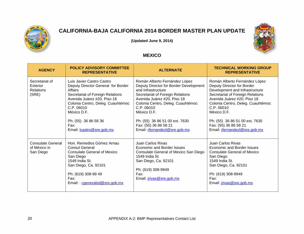
Secretariat of Exterior Relations (SRE)
Luis Javier Castro Castro Deputy Director General for Border Affairs Secretariat of Foreign Relations Avenida Juárez #20, Piso 18 Colonia Centro, Deleg. Cuauhtémoc C.P. 06010 México D.F. Ph: (55) 36 86 58 36 Fax: Email: [email protected]
Román Alberto Fernández López Deputy Director for Border Development and Infrastructure Secretariat of Foreign Relations Avenida Juárez #20, Piso 18 Colonia Centro, Deleg. Cuauhtémoc C.P. 06010 México D.F. Ph: (55) 36 86 51 00 ext. 7630 Fax: (55) 36 86 58 21 Email: [email protected]
Román Alberto Fernández López Deputy Director for Border Development and Infrastructure Secretariat of Foreign Relations Avenida Juárez #20, Piso 18 Colonia Centro, Deleg. Cuauhtémoc C.P. 06010 México D.F. Ph: (55) 36 86 51 00 ext. 7630 Fax: (55) 36 86 58 21 Email: [email protected]
Consulate General of México in San Diego
Hon. Remedios Gómez Arnau Consul General Consulate General of Mexico San Diego 1549 India St. San Diego, Ca. 92101 Ph: (619) 308-99 49 Fax: Email: : [email protected]
Juan Carlos Rivas Economic and Border Issues Consulate General of Mexico San Diego 1549 India St. San Diego, Ca. 92101 Ph: (619) 308-9949 Fax: Email: [email protected]
Juan Carlos Rivas Economic and Border Issues Consulate General of Mexico San Diego 1549 India St. San Diego, Ca. 92101 Ph: (619) 308-9949 Fax: Email: [email protected]
20
APPENDIX A-2: BMP Representatives Contact List
MEXICO
AGENCY POLICY ADVISORY COMMITTEE REPRESENTATIVE ALTERNATE TECHNICAL WORKING GROUP
REPRESENTATIVE
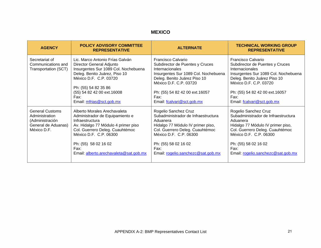
Secretariat of Communications and Transportation (SCT)
Lic. Marco Antonio Frías Galván Director General Adjunto Insurgentes Sur 1089 Col. Nochebuena Deleg. Benito Juárez, Piso 10 México D.F. C.P. 03720 Ph: (55) 54 82 35 86 (55) 54 82 42 00 ext.16008 Fax: Email: [email protected]
Francisco Calvario Subdirector de Puentes y Cruces Internacionales Insurgentes Sur 1089 Col. Nochebuena Deleg. Benito Juárez Piso 10 México D.F. C.P. 03720 Ph: (55) 54 82 42 00 ext.16057 Fax: Email: [email protected]
Francisco Calvario Subdirector de Puentes y Cruces Internacionales Insurgentes Sur 1089 Col. Nochebuena Deleg. Benito Juárez Piso 10 México D.F. C.P. 03720 Ph: (55) 54 82 42 00 ext.16057 Fax: Email: [email protected]
General Customs Administration (Administración General de Aduanas) México D.F.
Alberto Morales Arechavaleta Administrador de Equipamiento e Infraestructura Av. Hidalgo 77 Módulo 4 primer piso Col. Guerrero Deleg. Cuauhtémoc México D.F. C.P. 06300 Ph: (55) 58 02 16 02 Fax: Email: [email protected]
Rogelio Sanchez Cruz Subadministrador de Infraestructura Aduanera Hidalgo 77 Módulo IV primer piso, Col. Guerrero Deleg. Cuauhtémoc México D.F. C.P. 06300 Ph: (55) 58 02 16 02 Fax: Email: [email protected]
Rogelio Sanchez Cruz Subadministrador de Infraestructura Aduanera Hidalgo 77 Módulo IV primer piso, Col. Guerrero Deleg. Cuauhtémoc México D.F. C.P. 06300 Ph: (55) 58 02 16 02 Fax: Email: [email protected]
21

APPENDIX A-2: BMP Representatives Contact List
MEXICO
AGENCY POLICY ADVISORY COMMITTEE REPRESENTATIVE ALTERNATE TECHNICAL WORKING GROUP
REPRESENTATIVE
General Customs Administration (Administración General de Aduanas) Tijuana B.C.
Alejandro Gonzáles Guilbot Administrador de Aduana Av. Internacional Fraccionamiento Mesa de Otay Tijuana B.C. Ph: (664) 624 22 30 x 72230 Fax: (664) 624 22 48 Email:
Enrique Manjarrez Uriarte Subadministrador Av. Internacional Fraccionamiento Mesa de Otay Tijuana B.C. Ph: (664) 624 22 00 x72209 Fax: Email: [email protected]
Enrique Manjarrez Uriarte Subadministrador Av. Internacional Fraccionamiento Mesa de Otay Tijuana B.C. Ph: (664) 624 22 00 x72209 Fax: Email: [email protected]
Secretariat of Social Development (SEDESOL)
Lic. José Luis Llovera Abreu Director General de Desarrollo Urbano y Suelo Av. Paseo de la Reforma 333-2 Col. Cuauhtémoc Deleg. Cuauhtémoc México D.F. C.P. 06500 Ph: (55) 53 28 50 00 ext. 57402 Fax: Email: [email protected]
Lic. Salvador Gómez Rocha Director General Adjunto de Desarrollo Urbano y Suelo Av. Paseo de la Reforma 333-2 Col. Cuauhtémoc Deleg. Cuauhtémoc México D.F. C.P. 03720 Ph: (55) 53 28 50 00 ext. 57435 Fax: (55) 53 28 50 00 ext. 57475 Email: [email protected]
Lic. Salvador Gómez Rocha Director General Adjunto de Desarrollo Urbano y Suelo Av. Paseo de la Reforma 333-2 Col. Cuauhtémoc Deleg. Cuauhtémoc México D.F. C.P. 03720 Ph: (55) 53 28 50 00 ext. 57435 Fax: (55) 53 28 50 00 ext. 57475 Email: [email protected]
22

APPENDIX A-2: BMP Representatives Contact List
MEXICO
AGENCY POLICY ADVISORY COMMITTEE REPRESENTATIVE ALTERNATE TECHNICAL WORKING GROUP
REPRESENTATIVE
Institute of Administration and Estimates of National Real Estate (INDAABIN)
Carlos de la Fuente Director General de de Avaluos y Obras Avenida Mexico, No. 151 Col. Del Carmen Del. Coyoacan México D.F. 04100 Ph: (55) 55 63 25 92 Fax: [email protected]
Fernando Mas Roa Director de Programación y Contratación de Obras Avenida Mexico, No. 151 Col. Del Carmen Del. Coyoacan México D.F. 04100 Ph: (55) 55 63 26 99 x107 Email: [email protected]
Fidel Castañeda Lugo Subdirector de Proyectos Avenida Mexico, No. 151 Col. Del Carmen Del. Coyoacan México D.F. 04100 Ph: (55) 55 63 26 99 x220 [email protected] Salvador Lamas Padilla Administrador Único de Puertos Fronterizos Región Baja California I y Conjunto Pronaf Ensenada Linea International S//N Col. Federal Tijuana, BC 22010 Ph: 664-682-8426 Email: [email protected]
Office of the Governor of Baja California
Dr. Mario Gerardo Herrera Zárate Advisor to the Governor of Baja California Edificio Poder Ejecutivo 3 piso Centro Cívico Mexicali, B.C. C.P. 21000 Ph: (686) 558 11 24 Fax: Email: [email protected]
Lic. Mario Alberto Díaz Solís Oficina del Gobernador Coordinación General de Gabinete Director de Proyectos Estratégicos Edificio Poder Ejecutivo 3 piso Centro Cívico Mexicali, B.C. C.P. 21000 Ph: (686) 558 11 24 ext. 1053 Fax: (686) 558 10 00 ext. 1178 Email: [email protected]
Lic. Mario Alberto Díaz Solís Oficina del Gobernador Coordinación General de Gabinete Director de Proyectos Estratégicos Edificio Poder Ejecutivo 3 piso Centro Cívico Mexicali, B.C. C.P. 21000 Ph: (686) 558 11 24 ext. 1053 Fax: (686) 558 10 00 ext. 1178 Email: [email protected]
23

APPENDIX A-2: BMP Representatives Contact List
MEXICO
AGENCY POLICY ADVISORY COMMITTEE REPRESENTATIVE ALTERNATE TECHNICAL WORKING GROUP
REPRESENTATIVE
Secretariat of Infrastructure and Urban Development (SIDUE)
Ing. Manuel Guevara Morales Secretario de Infraestructura y Desarrollo Urbano del Estado SIDUE Edificio del Poder Ejecutivo 4 piso, Calzada Independencia No. 994 Centro Cívico Mexicali, B.C. C.P. 21000 Ph: (686) 558 11 16 Fax: (686) 558 19 65 Email: [email protected]
Arq. Germán Jesús Lizola Márquez Subsecretario de Infraestructura y Desarrollo Urbano del Estado SIDUE Edificio del Poder Ejecutivo 4 piso, Calzada Independencia No. 994 Centro Cívico Centro Cívico Mexicali, B.C. C.P. 21000 Ph: (686) 558 10000 X 1035 Fax: (686) 558 19 65 Email: [email protected]
Arq. Carlos López Rodríguez Director de Ordenamiento Territorial SIDUE Edificio del Poder Ejecutivo 5to piso, Calzada Independencia No. 994 Centro Cívico Mexicali, B.C. C.P. 21000 Ph: (686) 558 10 62 Fax: (686) 558 10 62 Email: [email protected] Karlo Omar Limón González SIDUE, Edificio del Poder Ejecutivo 5to piso, Calzada Independencia No. 994 Centro Cívico Mexicali, B.C. C.P. 21000 Ph: (686) 558 1000 Ext. 1476 Email: [email protected] Víctor Hugo Rangel Ramírez SIDUE, Edificio del Poder Ejecutivo 5to piso, Calzada Independencia No. 994 Centro Cívico Mexicali, B.C. C.P. 21000 Ph: (686) 558 1000 Email: [email protected]
24

APPENDIX A-2: BMP Representatives Contact List
MEXICO
AGENCY POLICY ADVISORY COMMITTEE REPRESENTATIVE ALTERNATE TECHNICAL WORKING GROUP
REPRESENTATIVE
Metropolitan Planning Institute of Tijuana (IMPlan)
Arq. Daniel Rubio Díaz de la Vega Director General Ejecutivo del Instituto Metropolitano de Planeación de Tijuana. Blv. Agua Caliente esq. Blv. Cuauhtémoc Col. Revolución Tijuana B.C. C.P. 22440 Ph: (664) 973 71 92 Fax: (664) 686 62 45 Email: [email protected]
Arq. MDU Rodolfo Argote Director de Planeación Territorial Instituto Metropolitano de Planeación de Tijuana. Blv. Agua Caliente esq. Blv. Cuauhtémoc Col. Revolución Tijuana B.C. C.P. 22440 Ph: (664) 686 62 48 Fax: (664) 686 62 45 Email: [email protected]
Ing. Óscar Cano Sauer Director de Enlace Instituto Metropolitano de Planeación de Tijuana. Blv. Agua Caliente esq. Blv. Cuauhtémoc Col. Revolución Tijuana B.C. C.P. 22440 Ph: (664) 686 62 48 Fax: (664) 686 62 45 Email: [email protected]
Municipal Institute of Research and Urban Planning of Mexicali (IMIP)
Mtro. Arq. Juventino Pérez Brambila Director General del Instituto Municipal de Investigación y Planeación Urbana de Mexicali Reforma 1087 entre “C” y “D” Mexicali, B.C. Ph: (686) 557 53 03 Fax: (686) 557 53 03 Email: [email protected]
Arq. Maria Adriana Macias Caballero Jefe del departamento de Planes y programas del Instituto Municipal de Investigación y Planeación Urbana de Mexicali Reforma 1087 entre “C” y “D” Mexicali, B.C. Ph: (686) 557 54 05 Fax: (686) 557 53 03 Email: [email protected]
Arq. Jesús Enrique Tapia Galindo Jefe del departamento de Proyectos estratégicos del Instituto Municipal de Investigación y Planeación Urbana de Mexicali Reforma 1087 entre “C” y “D” Mexicali, B.C. Ph: (686) 557 53 03 Fax: (686) 557 53 03 Email: [email protected]
25
APPENDIX A-2: BMP Representatives Contact List
MEXICO
AGENCY POLICY ADVISORY COMMITTEE REPRESENTATIVE ALTERNATE TECHNICAL WORKING GROUP
REPRESENTATIVE
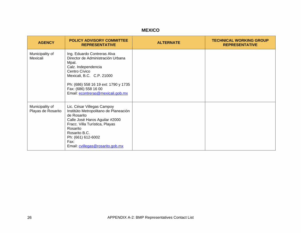
Municipality of Mexicali
Ing. Eduardo Contreras Alva Director de Administración Urbana Mpal. Calz. Independencia Centro Cívico Mexicali, B.C. C.P. 21000 Ph: (686) 558 16 19 ext: 1790 y 1735 Fax: (686) 558 16 00 Email: [email protected]
Municipality of Playas de Rosarito
Lic. César Villegas Campoy Institúto Metropolitano de Planeación de Rosarito Calle José Haros Aguilar #2000 Fracc. Villa Turística, Playas Rosarito Rosarito B.C. Ph: (661) 612-6002 Fax: Email: [email protected]
26

APPENDIX A-2: BMP Representatives Contact List
MEXICO
AGENCY POLICY ADVISORY COMMITTEE REPRESENTATIVE ALTERNATE TECHNICAL WORKING GROUP
REPRESENTATIVE
Municipality of Tecate
Arq. Karla Ivonne Moreno Director de Administración Urbana Mpal. Palacio Municipal Calle Ortíz Rubio y Cjón. Libertad Zona Centro Tecate, B.C. Ph: (665) 654 92 47 Fax: (665) 654 06 76 Email: [email protected]
Ivonne Anaya Calle Ortíz Rubio y Cjón. Libertad Zona Centro Tecate, B.C. Ph: (665) 654 92 47 Fax: (665) 654 06 76 Email: [email protected]
Ivonne Anaya Calle Ortíz Rubio y Cjón. Libertad Zona Centro Tecate, B.C. Ph: (665) 654 92 47 Fax: (665) 654 06 76 Email: [email protected]
Municipality of Tijuana
Roberto Sánchez Martínez Secretario de Desarrollo Urbano y Ecología Mpal. Calz. Independencia y Paseo del Centenario Tijuana B.C. Ph: (664) Fax: (664) Email: [email protected]
Ana Lilia Loaiza Martinez Directora del Control Urbano Municipal Calz. Independencia y Paseo del Centenario Tijuana B.C. Ph: (664) 973 71 33 ext. 7275 Fax: Email: [email protected]
27
APPENDIX A-2: BMP Representatives Contact List
UNITED STATES
Invited Agencies
AGENCY POLICY ADVISORY COMMITTEE REPRESENTATIVE ALTERNATE TECHNICAL WORKING GROUP
REPRESENTATIVE
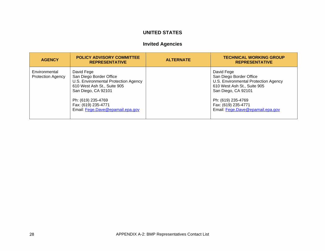
Environmental Protection Agency
David Fege San Diego Border Office U.S. Environmental Protection Agency 610 West Ash St., Suite 905 San Diego, CA 92101 Ph: (619) 235-4769 Fax: (619) 235-4771 Email: [email protected]
David Fege San Diego Border Office U.S. Environmental Protection Agency 610 West Ash St., Suite 905 San Diego, CA 92101 Ph: (619) 235-4769 Fax: (619) 235-4771 Email: [email protected]
28

APPENDIX A-2: BMP Representatives Contact List
MEXICO
Invited Agencies
AGENCY POLICY ADVISORY COMMITTEE REPRESENTATIVE ALTERNATE TECHNICAL WORKING GROUP
REPRESENTATIVE
National Immigration Institute of Mexico (INM)
Rodulfo Figueroa Pacheco Delegado Regional Blvd. Diamante s/n esq. con Cuarzo Fracc. La Esmeralda Tijuana B.C. Ph: (664) 636 60 22 ext.1 Fax: Email: [email protected]
Raúl Pareyon Castillo Subdelegado Federal en Baja California Puerta de México, Col. Federa Tijuana B.C. C.P. 22310 Ph: (664) 682 98 62 Fax: Email: [email protected]
Raúl Pareyon Castillo Subdelegado Federal en Baja California Puerta de México, Col. Federa Tijuana B.C. C.P. 22310 Ph: (664) 682 98 62 Fax: Email: [email protected]
Secretariat of Economic Development Baja California
Carlo Humberto Bonfante Olache Secretario de Desarrollo Economico SEDECO Mexicali Edificio Poder Ejecutivo 4 piso Calz. Independencia 994 Centro Cívico- Mexicali B.C. 21000 Ph: (686) 558 10 00 ext. 1049 Fax: (686) 558 10 00 ext. 1192 Email: [email protected]
Jesús Alfredo Babún Villarreal Subsecretario de Desarrollo Económico SEDECO Mexicali Edificio Poder Ejecutivo 4 piso Calz. Independencia 994 Centro Cívico- Mexicali B.C. 21000 Ph: (686) 558 16 00 ext. 1568 Fax: Email: [email protected]
Lic. Francisco Verduzco Ortíz Subdirector de Planeación Sectorial y Competitividad. SEDECO Mexicali Edificio Poder Ejecutivo 4 piso Calz. Independencia 994 Centro Cívico- Mexicali B.C. 21000 Ph: (686) 558 16 00 ext. 1568 Fax: Email: [email protected]
29

APPENDIX A-2: BMP Representatives Contact List
MEXICO
Invited Agencies
AGENCY POLICY ADVISORY COMMITTEE REPRESENTATIVE ALTERNATE TECHNICAL WORKING GROUP
REPRESENTATIVE
Baja California Secretariat of Tourism
Oscar Escobedo Carignan Secretario de Turismo Edificio Juan Ruíz de Alarcón 1572 Zona Río 3 piso Tijuana B.C. Ph: (664) 682 33 67 Fax: (664) 682 90 61 Email: [email protected]
Ives Lelevier Ramos Subsecretario Edificio Juan Ruíz de Alarcón 1572 Zona Río 3 piso Tijuana B.C. Ph: (664) 682 33 67 Fax: (664) 682 90 61 Email: [email protected]
José Francisco Patiño Jauregui Director de Fomento a la Inversión Edificio Juan Ruíz de Alarcón 1572 Zona Río 3 piso Tijuana B.C. Ph: (664) 682 33 67 Fax: (664) 682 90 61 Email: [email protected]
Secretariat of Municipal Economic Development Tijuana
Xavier Peniche Bustamante Secretario de Desarrollo Economico Palacio Municipal 2 nivel Av. Indepedencia 1350 Tijuana B.C. Ph: (664) 973 70 36 Ext. 7553 Fax: (664) 973 70 37 Email: [email protected]
30
Appendix A-3: Schedule of Meetings
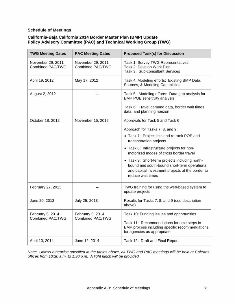
Schedule of Meetings California-Baja California 2014 Border Master Plan (BMP) Update Policy Advisory Committee (PAC) and Technical Working Group (TWG)
TWG Meeting Dates PAC Meeting Dates Proposed Task(s) for Discussion
November 29, 2011 Combined PAC/TWG
November 29, 2011 Combined PAC/TWG
Task 1: Survey TWG Representatives Task 2: Develop Work Plan Task 3: Sub-consultant Services
April 19, 2012 May 17, 2012 Task 4: Modeling efforts: Existing BMP Data, Sources, & Modeling Capabilities
August 2, 2012 -- Task 5: Modeling efforts: Data gap analysis for BMP POE sensitivity analysis Task 6: Travel demand data, border wait times data, and planning horizon
October 18, 2012 November 15, 2012 Approvals for Task 5 and Task 6 Approach for Tasks 7, 8, and 9:
• Task 7: Project lists and re-rank POE and transportation projects
• Task 8: Infrastructure projects for non-motorized modes of cross border travel
• Task 9: Short-term projects including north-bound and south-bound short-term operational and capital investment projects at the border to reduce wait times
February 27, 2013 -- TWG training for using the web-based system to update projects
June 20, 2013 July 25, 2013 Results for Tasks 7, 8, and 9 (see description above)
February 5, 2014 Combined PAC/TWG
February 5, 2014 Combined PAC/TWG
Task 10: Funding issues and opportunities Task 11: Recommendations for next steps in BMP process including specific recommendations for agencies as appropriate
April 10, 2014 June 12, 2014 Task 12: Draft and Final Report
Note: Unless otherwise specified in the tables above, all TWG and PAC meetings will be held at Caltrans offices from 10:30 a.m. to 1:30 p.m. A light lunch will be provided.
31

This page intentionally left blank

APPENDIX A-4: Policy Advisory Committee Meeting Agreements and Approvals
California-Baja California 2014 Border Master Plan (BMP) Update Policy Advisory Committee (PAC) and Technical Working Group (TWG)
November 29, 2011 Meeting Summary of Agreements and Approvals
Attendance:
Appendix A-5 lists the participants who attended or participated via teleconference call in the joint PAC/TWG Kick-off meeting on November 29, 2011.
Summary of Agreements:
1. The PAC approved the appointment of the California Department of Transportation (Caltrans) and the Secretariat of Infrastructure and Urban Development of Baja California (SIDUE) as co-chairs of both the PAC and the TWG.
2. The PAC approved the revisions to the charter thereby re-establishing the PAC and the TWG for the California-Baja California 2014 BMP Update (originally included in Agenda Item 4A of the agenda).
3. The Federal Highway Administration (FHWA) agreed to contact the representative from Arizona’s Department of Transportation, who is coordinating the Arizona-Sonora Border Master Plan, and inform him of California and Baja California’s willingness to be of help and to report the request from Imperial County Transportation Commission’s Executive Director to participate in the Arizona-Sonora Border Master Plan effort.
4. The PAC approved the Border Master Plan Update’s Hybrid Scope of Work with modifications and additional funding of $106,000, contingent upon contracting agreements between Caltrans and SANDAG Service Bureau being executed by March 2012. The modifications are outlined below and the Approved Scope of Work with modifications is included in Attachment 1.
a. Delete New Concept 6 (discuss potential of creating a web portal to provide information on cross border projects and efforts);
b. Delete New Concept 8 (consider potential for creating an entity to serve as border clearing house for border related issues and/or tolling authority);
c. Add New Concept 2 (update travel demand data, border wait times data, and planning horizon and re-rank Port of Entry (POE) and connecting transportation projects);
d. Classify POE projects by types of infrastructure (i.e., new infrastructure and modernization of existing infrastructure) and rank projects within their own classification.
5. The FHWA suggested that there may be funding to explore the development of a white paper on the creation of an entity to serve as single clearing house for border related issues and/or tolling authority. The Secretariat of Communications and Transportation (SCT) offered to provide language that would facilitate a funding request to explore the potential creation of a clearing house or tolling authority.
Next Meeting Dates and Location:
The proposed meeting dates for conducting the approved Scope of Work is shown in Attachment 2. The meetings will be held at the Caltrans offices in San Diego.
33
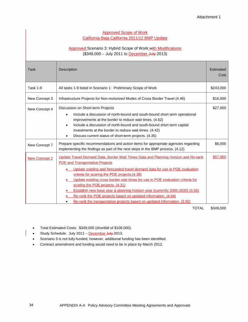
Attachment 1
APPENDIX A-4: Policy Advisory Committee Meeting Agreements and Approvals
Approved Scope of Work California-Baja California 2011/12 BMP Update
Approved Scenario 3: Hybrid Scope of Work with Modifications ($349,000 – July 2011 to December July 2013)
Task Description Estimated Cost
Task 1-9 All tasks 1-9 listed in Scenario 1: Preliminary Scope of Work $243,000
New Concept 3 Infrastructure Projects for Non-motorized Modes of Cross Border Travel (4.46) $16,000
New Concept 4 Discussion on Short-term Projects
• Include a discussion of north-bound and south-bound short term operational improvements at the border to reduce wait times. (4.62)
• Include a discussion of north-bound and south-bound short term capital investments at the border to reduce wait times. (4.42)
• Discuss current status of short-term projects. (4.35)
$27,000
New Concept 7 Prepare specific recommendations and action items for appropriate agencies regarding implementing the findings as part of the next steps in the BMP process. (4.12)
$6,000
New Concept 2 Update Travel Demand Data, Border Wait Times Data and Planning Horizon and Re-rank POE and Transportation Projects
• Update existing and forecasted travel demand data for use in POE evaluation criteria for scoring the POE projects.(4.38)
• Update existing cross border wait times for use in POE evaluation criteria for scoring the POE projects. (4.31)
• Establish new base year & planning horizon year (currently 2005-2030) (3.50) • Re-rank the POE projects based on updated information. (4.04) • Re-rank the transportation projects based on updated information. (3.92)
$57,000
TOTAL $349,000
• Total Estimated Costs: $349,000 (shortfall of $106,000). • Study Schedule: July 2011 – December July 2013. • Scenario 3 is not fully-funded; however, additional funding has been identified. • Contract amendment and funding would need to be in place by March 2012.
34

APPENDIX A-4: Policy Advisory Committee Meeting Agreements and Approvals
Attachment 2
California-Baja California Border Master Plan (BMP) Update Proposed PAC and TWG Meeting Schedule
for the Approved Scope of Work
Technical Working Group (TWG) Proposed Meeting Date
Proposed Task(s) for Discussion
August 2, 2012
Task 5: Modeling efforts: Data gap analysis for BMP POE sensitivity analysis Task 6: Travel demand data, border wait times data, and planning horizon
October 18, 2012
Approach for Tasks 7, 8, and 9 Task 7: Project lists and re-rank POE and transportation projects Task 8: Infrastructure projects for non-motorized modes of cross border travel Task 9: Short-term projects including north-bound and south-bound short-term operational and capital investment projects at the border to reduce wait times
December 4, 2012 (US agencies) December 5, 2012 (Mexico agencies)
TWG training for using the web-based system to update projects
March 21, 2013
Results for Tasks 7, 8, and 9 (see description above)
June 20, 2013
Task 10: Funding issues and opportunities Task 11: Recommendations for next steps in BMP process including specific recommendations for agencies as appropriate
October 17, 2013
Task 12: Draft Report
35

APPENDIX A-4: Policy Advisory Committee Meeting Agreements and Approvals
Policy Advisory Committee (PAC) Proposed Meeting Date
Proposed Task(s) for Discussion/Approval
May 17, 2012
Task 4: Modeling efforts: Existing BMP Data, Sources, & Modeling Capabilities
September 20, 2012 * (* see note below)
Task 5: Modeling efforts: Data gap analysis for BMP POE sensitivity analysis Task 6: Travel demand data, border wait times data, and planning horizon
November 15, 2012
Approach for Tasks 7, 8, and 9 Task 7: Project lists and re-rank POE and transportation projects Task 8: Infrastructure projects for non-motorized modes of cross border travel Task 9: Short-term projects including north-bound and south-bound short-term operational and capital investment projects at the border to reduce wait times
April 18, 2013
Results for Tasks 7, 8, and 9 (see description above)
July 18, 2013
Task 10: Funding issues and opportunities Task 11: Recommendations for next steps in BMP process including specific recommendations for agencies as appropriate
December 12, 2013
Task 12: Final Report
* Please note: This PAC meeting date was changed from September 20, 2012 to September 11, 2012 and the time was changed to 12 p.m. to 3 p.m.
Note: TWG and PAC meetings will be held at Caltrans offices from 10:30 a.m. to 1:30 p.m. A light lunch will be provided.
36

APPENDIX A-4: Policy Advisory Committee Meeting Agreements and Approvals
California-Baja California 2014 Border Master Plan (BMP) Update Policy Advisory Committee (PAC)
May 17, 2012 Meeting Summary of Agreements and Approvals
Attendance:
Appendix A-5 lists the participants who attended the May 17, 2012, meeting, or participated via teleconference call.
Summary of Agreements:
1. Upon a motion from the Imperial County Transportation Commission (ICTC) and second by the Federal Highway Administration (FHWA), the PAC approved the proposed approach outlined in Agenda Item 7 for completing Task 5 on the modeling gap analysis and the Port of Entry (POE) sensitivity analysis and performance measures.
2. Upon a motion from ICTC and second by the U.S. General Services Administration (GSA) the PAC approved the approach outlined in Agenda Item 8 for:
a. Updating travel demand data for use in ranking POEs and associated transportation projects.
b. Updating socio-economic data for use in preparing profiles for the Area of Influence.
c. Revising Table 3 to note that border wait time data will be provided by SANDAG and the U.S. Customs and Border Protection (CBP) based on information from the CBP website. (Refer to Attachment 1 to review revised Table 3.)
3. Upon a motion from the Secretariat of External Relations of Mexico (SRE) and second by the City of Calexico, the PAC approved as the BMP’s base year 2010 with 2040 as planning horizon.
Next Meeting Dates and Location:
The next Technical Working Group (TWG) meeting is scheduled for Thursday, August 2, 2012, from 10:30 a.m. to 1:30 p.m. The next PAC meeting is scheduled on Tuesday, September 11, 2012, from 12 noon to 3 p.m. The meetings will be held at the Caltrans offices in San Diego.
37

APPENDIX A-4: Policy Advisory Committee Meeting Agreements and Approvals
ATTACHMENT 1
Revision to Table 3 (Agenda Item 8) as Approved by PAC at May 17, 2012 Meeting Table 3: POE Capacity Data
POE CAPACITY Proposed Agency to Provide Data Direction
2010 Sq. Footage GSA / INDAABIN Forecasted Sq. Footage GSA / INDAABIN 2010 No. Lanes by type GSA / INDAABIN Forecasted No. Lanes by type GSA / INDAABIN 2010 No. Inspection Spaces Passenger Vehicles GSA / INDAABIN Trucks GSA / INDAABIN Forecasted No. Inspection Spaces Passenger Vehicles GSA / INDAABIN Trucks GSA / INDAABIN 2010 No. Inspection Personnel CBP / Aduanas Optimum No. Inspection Personnel CBP / Aduanas Forecasted No. Inspection Personnel CBP / Aduanas Forecasted Optimum No. Inspect Personnel CBP / Aduanas 2010 Average Daily Inspection Time Passenger Vehicle Regular Lanes CBP/ GSA / Aduanas Northbound / Southbound Passenger Vehicle SENTRI Lanes CBP/ GSA Northbound Passenger Vehicle Ready Lanes CBP/ GSA Northbound Truck Regular Lanes CBP/ GSA / Aduanas Northbound / Southbound FAST Lanes CBP/ GSA / Aduanas Northbound / Southbound Pedestrian Lane CBP/ GSA Northbound Bus Lane CBP/ GSA / Aduanas Northbound / Southbound 2010 Average Daily Vehicles Processed/Throughput Passenger Vehicle Regular Lanes CBP / Aduanas Northbound / Southbound Passenger Vehicle SENTRI Lanes CBP Northbound Passenger Vehicle Ready Lane CBP Northbound Truck Regular Lanes CBP / Aduanas Northbound / Southbound FAST Lanes CBP / Aduanas Northbound / Southbound Pedestrian Lane CBP Northbound Bus Lane CBP / Aduanas Northbound / Southbound 2010 Average Daily & Peak Border Wait Time * Passenger Vehicle Regular Lanes SANDAG / CBP Northbound Passenger Vehicle SENTRI Lanes SANDAG / CBP Northbound Passenger Vehicle Ready Lanes SANDAG / CBP Northbound Trucks Regular Lanes SANDAG / CBP Northbound FAST Lanes SANDAG / CBP Northbound Pedestrian Regular Lanes SANDAG / CBP Northbound Pedestrian Ready Lanes SANDAG / CBP Northbound
* Border Wait Times data will be provided by SANDAG and U.S. Customs and Border Protection (CBP) based on information from the CBP Web site SANDAG has been collecting Border northbound wait time data from the CBP website for two years. Data could be summarized for this effort. Southbound wait times are not available.
REV I S E D
38

APPENDIX A-4: Policy Advisory Committee Meeting Agreements and Approvals
California-Baja California 2014 Border Master Plan (BMP) Update Policy Advisory Committee Meeting
November 15, 2012 Summary of Agreements and Approvals
Attendance:
Appendix A-5 lists the participants who attended the November 15, 2012 meeting or participated via teleconference call.
Summary of Agreements
1. Agenda Item 4, Updating Project Lists and Re-Ranking Port of Entry (POE) and Transportation Projects (Task 6): The PAC approved the following:
A. Time periods for short-term (defined as 2013-2014); medium-term (2015-2020); and long-term (2021-2040). (Federal Highway Administration (FHWA) / Secretariat of Foreign Relations (SRE))
B. Use of Option 4, which applies Construction Phase and Funding Status screening criteria, for determining which projects are ranked. The process is outlined below. One modification with respect to fully funded projects is described in bullet 5) below. The flowchart for Option 4 is illustrated in Attachment 1.
1) The time periods for short-, medium-, and long-term represent “date open to traffic.”
2) Short-term projects will not be ranked; they will be catalogued for information purposes.
3) Projects that are under construction during the short-term period (2013-2014) will not be ranked even if open to traffic date is after Dec. 31, 2014.
4) Projects that are fully funded will not be ranked regardless of the time period.
5) Modification: At the request of the PAC, the BMP will create a second list that will rank all projects submitted except the short-term and those under construction during short-term period (regardless of completion date). This list will also rank fully funded projects. The purpose of this list is that in case a project loses funding, its relative ranking could be used in efforts to pursue needed monies in the future. This list will be included in the appendix of the final report and will be referred to as BMP 2013-2014 Expanded List of Ranked Projects.
(SRE / General Services Administration (GSA)
2. Agenda Item 5: Non-motorized and short-term operational and minor capital investment projects (Tasks 8 and 9, respectively). The PAC approved the following:
A. Definition of non-motorized projects and the definition of short-term operational and minor capital investment projects to reduce border wait times. The definitions are:
1) Non-motorized projects are walking and bicycling capital infrastructure projects.
2) Short-term operational and minor capital investment projects are projects that intend to facilitate federal processing of pedestrians and vehicles at the POEs and thus expedite the flow of people and cargo. Minor capital investment projects are infrastructure improvements that have a
39

APPENDIX A-4: Policy Advisory Committee Meeting Agreements and Approvals
relatively low monetary cost and may be stand-alone projects or associated with an operational improvement.
3) Three distinguishing characteristics of these projects are:
a) The projects have completion dates within the “short term” timeframe of 2013-2014 b) The projects have a clear nexus to reducing border wait times c) The capital project has a cost of less than $3 million U.S. dollars
B. Approach to conduct Tasks 8 (non-motorized projects) as follows with one modification described in bullet 4) below:
1) Non-motorized modes (walking and bicycling) would be cataloged for reference but not ranked.
2) The projects submitted should be included in an existing and approved planning document of one, or more, BMP participating agency.
3) BMP agency participants will be asked to submit these projects via the Web-based data entry system developed for the BMP Update.
4) Modification: The PAC recommended that the next California-Baja California Border Master Plan Update include a task to develop a methodology and establish new evaluation criteria to rank non-motorized projects
C. Approach to conduct Task 9 (short-term operational and minor capital investment projects) as follows:
1) Short-term operational and minor capital investment projects to reduce border wait times would be cataloged for reference but not ranked.
2) The projects could be included in an existing and approved planning document or they may be innovative ideas for reducing border wait times not included in any planning document.
3) BMP agency participants will be asked to submit these projects via the Web-based data entry system.
(FHWA / City of Calexico)
3. Agenda Item 6: Updating data for use in evaluation criteria (Task 6). The PAC accepted the data in the following categories for use in the evaluation criteria for ranking projects. (Refer to Attachment 2 for the specific data elements.):
A. Northbound border crossings (2010 and 2040),
B. Northbound value and volume of goods by truck and by rail (2010), and
C. The relative order of the POEs in terms of northbound border wait times
(FHWA / Department of State (DOS)
4. Agenda Item 7: Framework for a Future Model to Conduct POE Sensitivity Analysis (Task 5): The PAC accepted the framework, performance measures, gap analysis, cost estimates, and recommendations regarding a future transportation demand model that could also perform sensitivity analyses. (Refer to Attachment 3 for the recommendations and cost estimate.) (FHWA / SRE)
40
APPENDIX A-4: Policy Advisory Committee Meeting Agreements and Approvals
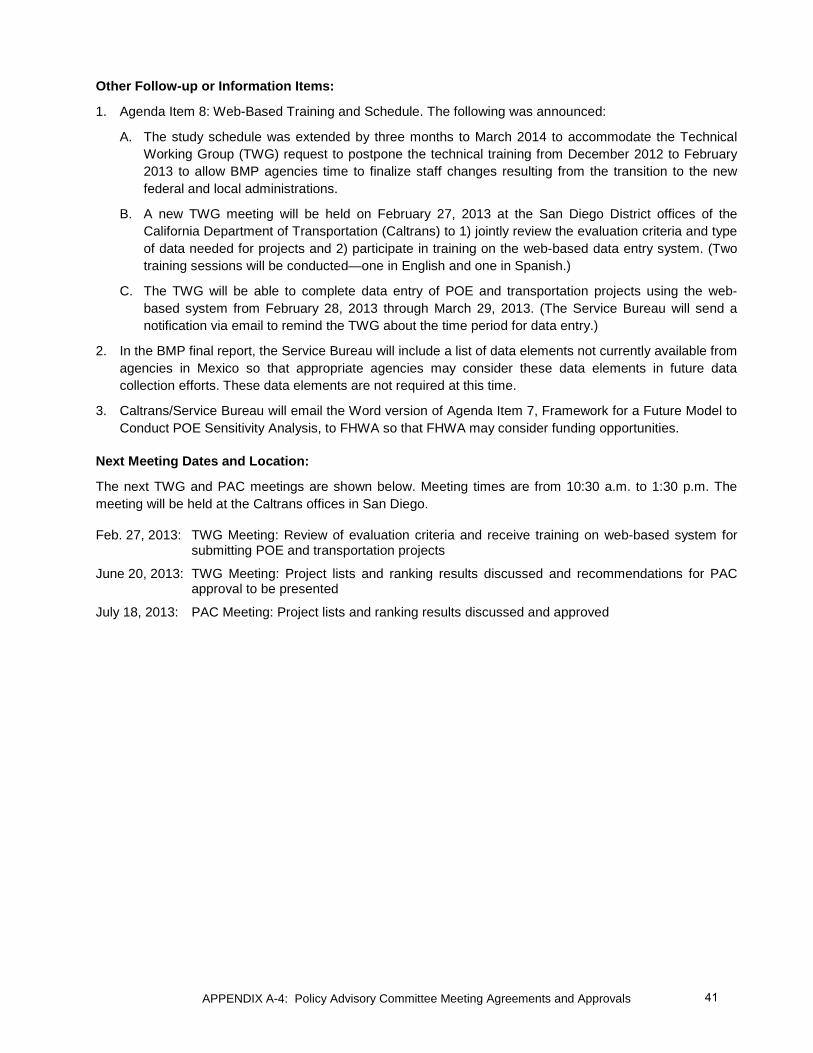
Other Follow-up or Information Items:
1. Agenda Item 8: Web-Based Training and Schedule. The following was announced:
A. The study schedule was extended by three months to March 2014 to accommodate the Technical Working Group (TWG) request to postpone the technical training from December 2012 to February 2013 to allow BMP agencies time to finalize staff changes resulting from the transition to the new federal and local administrations.
B. A new TWG meeting will be held on February 27, 2013 at the San Diego District offices of the California Department of Transportation (Caltrans) to 1) jointly review the evaluation criteria and type of data needed for projects and 2) participate in training on the web-based data entry system. (Two training sessions will be conducted—one in English and one in Spanish.)
C. The TWG will be able to complete data entry of POE and transportation projects using the web-based system from February 28, 2013 through March 29, 2013. (The Service Bureau will send a notification via email to remind the TWG about the time period for data entry.)
2. In the BMP final report, the Service Bureau will include a list of data elements not currently available from agencies in Mexico so that appropriate agencies may consider these data elements in future data collection efforts. These data elements are not required at this time.
3. Caltrans/Service Bureau will email the Word version of Agenda Item 7, Framework for a Future Model to Conduct POE Sensitivity Analysis, to FHWA so that FHWA may consider funding opportunities.
Next Meeting Dates and Location:
The next TWG and PAC meetings are shown below. Meeting times are from 10:30 a.m. to 1:30 p.m. The meeting will be held at the Caltrans offices in San Diego.
Feb. 27, 2013: TWG Meeting: Review of evaluation criteria and receive training on web-based system for submitting POE and transportation projects
June 20, 2013: TWG Meeting: Project lists and ranking results discussed and recommendations for PAC approval to be presented
July 18, 2013: PAC Meeting: Project lists and ranking results discussed and approved
41

APPENDIX A-4: Policy Advisory Committee Meeting Agreements and Approvals
Attachment 1
Flowchart for Option 4 Approach for Ranking Projects Construction and Funding Screening Criteria Applied
42
APPENDIX A-4: Policy Advisory Committee Meeting Agreements and Approvals
Attachment 2
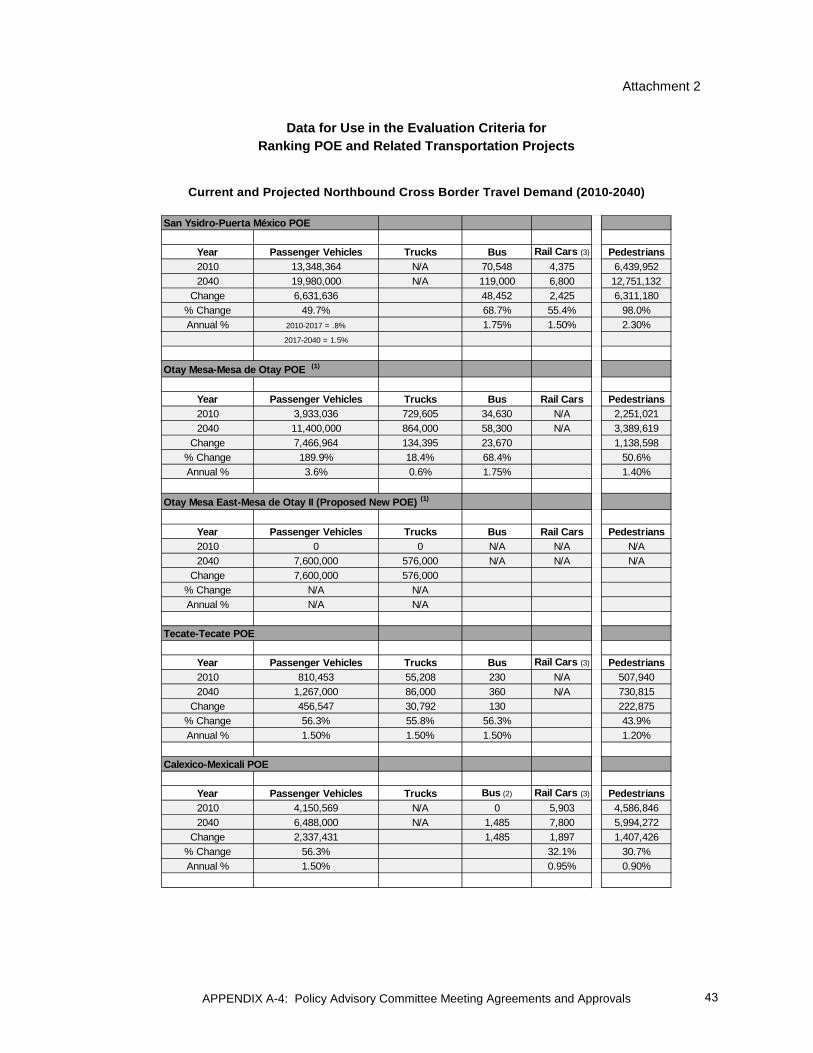
Data for Use in the Evaluation Criteria for Ranking POE and Related Transportation Projects
Current and Projected Northbound Cross Border Travel Demand (2010-2040)
San Ysidro-Puerta México POE
Year Passenger Vehicles Trucks Bus Rail Cars (3) Pedestrians2010 13,348,364 N/A 70,548 4,375 6,439,9522040 19,980,000 N/A 119,000 6,800 12,751,132
Change 6,631,636 48,452 2,425 6,311,180% Change 49.7% 68.7% 55.4% 98.0%Annual % 2010-2017 = .8% 1.75% 1.50% 2.30%
2017-2040 = 1.5%
Otay Mesa-Mesa de Otay POE (1)
Year Passenger Vehicles Trucks Bus Rail Cars Pedestrians2010 3,933,036 729,605 34,630 N/A 2,251,0212040 11,400,000 864,000 58,300 N/A 3,389,619
Change 7,466,964 134,395 23,670 1,138,598% Change 189.9% 18.4% 68.4% 50.6%Annual % 3.6% 0.6% 1.75% 1.40%
Otay Mesa East-Mesa de Otay II (Proposed New POE) (1)
Year Passenger Vehicles Trucks Bus Rail Cars Pedestrians2010 0 0 N/A N/A N/A2040 7,600,000 576,000 N/A N/A N/A
Change 7,600,000 576,000% Change N/A N/AAnnual % N/A N/A
Tecate-Tecate POE
Year Passenger Vehicles Trucks Bus Rail Cars (3) Pedestrians2010 810,453 55,208 230 N/A 507,9402040 1,267,000 86,000 360 N/A 730,815
Change 456,547 30,792 130 222,875% Change 56.3% 55.8% 56.3% 43.9%Annual % 1.50% 1.50% 1.50% 1.20%
Calexico-Mexicali POE
Year Passenger Vehicles Trucks Bus (2) Rail Cars (3) Pedestrians2010 4,150,569 N/A 0 5,903 4,586,8462040 6,488,000 N/A 1,485 7,800 5,994,272
Change 2,337,431 1,485 1,897 1,407,426% Change 56.3% 32.1% 30.7%Annual % 1.50% 0.95% 0.90%
43
APPENDIX A-4: Policy Advisory Committee Meeting Agreements and Approvals
Source: U.S. Bureau of Transportation Statistics (BTS) (2010) and Caltrans (passenger vehicles, trucks, bus and rail cars, 2040) and SIDUE (pedestrian crossings, 2040) Notes: Forecast assumptions based on BTS historical crossing data, historic growth rates by POE and mode, and regional demographic forecast estimates. Forecast is for planning and study purposes only. Numbers are rounded. (1) The forecast is also based on SR-11 and Otay Mesa East POE Final Tier II EIR – March 2012.
http://www.dot.ca.gov/dist11/Env_docs/SR11/Final_tech.html. It assumes a 60/40 split between Otay Mesa and Otay Mesa East POEs.
(2) Buses began primarily using Calexico East POE in 2008. Estimate assumes resumed bus crossings at Calexico West POE once modernization of POE is complete.
(3) Rail crossings are shown at the POE where the crossing actually occurs.
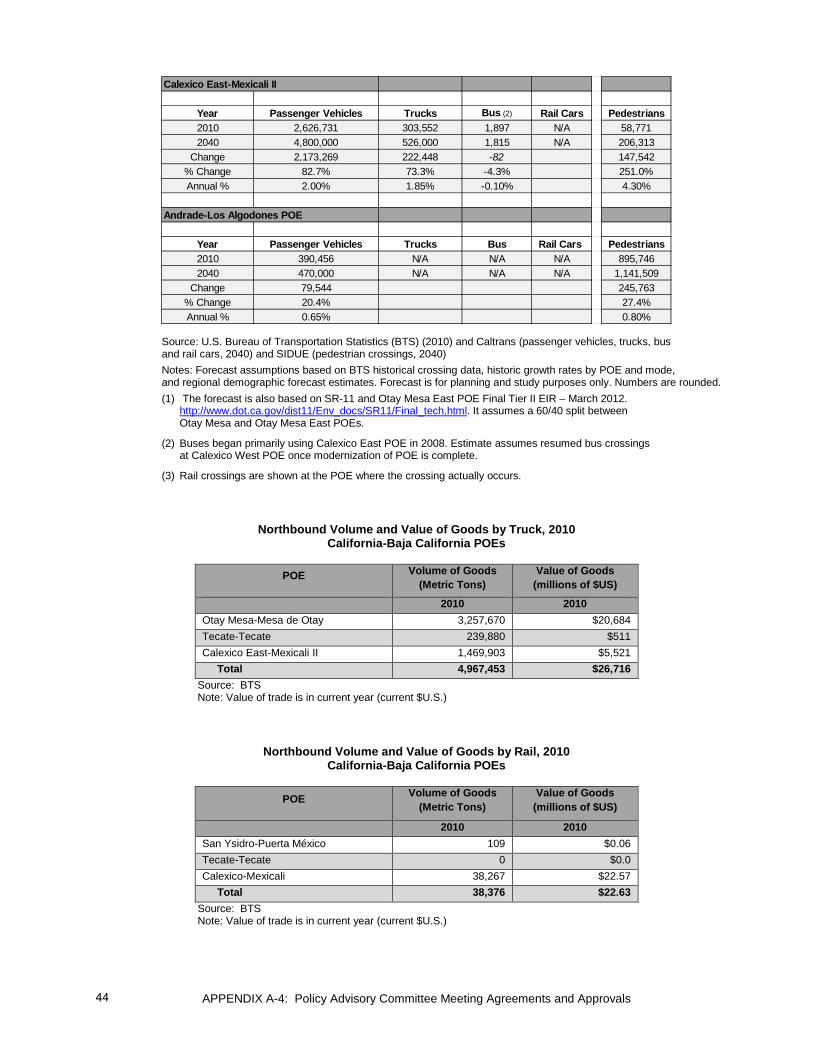
Northbound Volume and Value of Goods by Truck, 2010 California-Baja California POEs
POE Volume of Goods
(Metric Tons) Value of Goods
(millions of $US)
2010 2010 Otay Mesa-Mesa de Otay 3,257,670 $20,684 Tecate-Tecate 239,880 $511 Calexico East-Mexicali II 1,469,903 $5,521 Total 4,967,453 $26,716
Source: BTS Note: Value of trade is in current year (current $U.S.)
Northbound Volume and Value of Goods by Rail, 2010 California-Baja California POEs
POE Volume of Goods
(Metric Tons) Value of Goods
(millions of $US)
2010 2010 San Ysidro-Puerta México 109 $0.06 Tecate-Tecate 0 $0.0 Calexico-Mexicali 38,267 $22.57 Total 38,376 $22.63
Source: BTS Note: Value of trade is in current year (current $U.S.)
Calexico East-Mexicali II
Year Passenger Vehicles Trucks Bus (2) Rail Cars Pedestrians2010 2,626,731 303,552 1,897 N/A 58,7712040 4,800,000 526,000 1,815 N/A 206,313
Change 2,173,269 222,448 -82 147,542% Change 82.7% 73.3% -4.3% 251.0%Annual % 2.00% 1.85% -0.10% 4.30%
Andrade-Los Algodones POE
Year Passenger Vehicles Trucks Bus Rail Cars Pedestrians2010 390,456 N/A N/A N/A 895,7462040 470,000 N/A N/A N/A 1,141,509
Change 79,544 245,763% Change 20.4% 27.4%Annual % 0.65% 0.80%
44

APPENDIX A-4: Policy Advisory Committee Meeting Agreements and Approvals
Relative order of the POEs in Terms of Northbound Border Wait Times
The relative position of POEs by weekday average peak period wait times for the different modes are shown in the figures below. The POE with the longest northbound wait time is shown as 100 percent.
Figure 1
Relative Wait Time for Northbound Privately Owned Vehicles Regular Lanes Average Daily Peak Period Wait Times, Weekday (Mon-Fri)
California-Baja California POEs
Source: U.S. Customs and Border Protection (CBP); compiled by San Diego Association of Governments (SANDAG) Notes: Weekday (Mon-Fri), October 27, 20122 – August 9, 2012. The Peak Period is from 5 to 9 a.m. and 3 to 7 p.m. for the San Ysidro-Puerta México, Otay Mesa-Mesa de Otay, Tecate-Tecate, and Calexico-Mexicali POEs. The Peak Period is from 6 to 9 a.m. and 3 to 7 p.m. for the Calexico East-Mexicali II and Andrade-Los Algodones POE.
Figure 2 Relative Wait Time for Northbound Commercial Truck Regular Lanes
Average Daily Peak Period Wait Times, Weekday (Mon-Fri) California-Baja California POEs
Source: U.S. CBP; compiled by SANDAG Notes: Weekday (Mon-Fri), October 27, 20122 – August 9, 2012. Peak Period is from 2 to 6 p.m. for Otay Mesa-Mesa de Otay and Calexico East-Mexicali II and 2 to 4 p.m. for Tecate-Tecate.
26%
35%
55%
55%
60%
100%
Andrade-Los Algodones
Tecate-Tecate
Calexico East-Mexicali II
Otay Mesa-Mesa de Otay
Calexico-Mexicali I
San Ysidro-Puerta México
21%
79%
100%
Tecate-Tecate
Calexico East-Mexicali II
Otay Mesa-Mesa de Otay
45

APPENDIX A-4: Policy Advisory Committee Meeting Agreements and Approvals
Figure 3
Relative Wait Time for Northbound Pedestrian Regular Lanes Average Daily Peak Period Wait Times, Weekday (Mon-Fri)
California-Baja California POEs
Source: U.S. CBP; compiled by SANDAG Notes: Weekday (Mon-Fri), October 27, 20122 – August 9, 2012. The Peak Period is from 5 to 9 a.m. and 3 to 7 p.m. for the San Ysidro-Puerta México, Otay Mesa-Mesa de Otay, Tecate-Tecate, and Calexico-Mexicali POEs. The Peak Period is from 6 to 9 a.m. and 3 to 7 p.m. for the Calexico East-Mexicali II and Andrade-Los Algodones POE.
0%
9%
9%
39%
50%
100%
Calexico East-Mexicali II
Andrade-Los Algodones
Tecate-Tecate
Calexico-Mexicali I
Otay Mesa-Mesa de Otay
San Ysidro-Puerta México
46
APPENDIX A-4: Policy Advisory Committee Meeting Agreements and Approvals
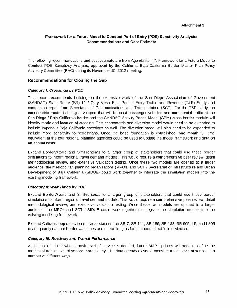
Attachment 3
Framework for a Future Model to Conduct Port of Entry (POE) Sensitivity Analysis: Recommendations and Cost Estimate
The following recommendations and cost estimate are from Agenda item 7, Framework for a Future Model to Conduct POE Sensitivity Analysis, approved by the California-Baja California Border Master Plan Policy Advisory Committee (PAC) during its November 15, 2012 meeting.
Recommendations for Closing the Gap
Category I: Crossings by POE
This report recommends building on the extensive work of the San Diego Association of Government (SANDAG) State Route (SR) 11 / Otay Mesa East Port of Entry Traffic and Revenue (T&R) Study and companion report from Secretariat of Communications and Transportation (SCT). For the T&R study, an econometric model is being developed that will forecast passenger vehicles and commercial traffic at the San Diego / Baja California border and the SANDAG Activity Based Model (ABM) cross border module will identify mode and location of crossing. This econometric and diversion model would need to be extended to include Imperial / Baja California crossings as well. The diversion model will also need to be expanded to include more sensitivity to pedestrians. Once the base foundation is established, one month full time equivalent at the four regional planning agencies could be used to update the model framework and data on an annual basis.
Expand BorderWizard and SimFronteras to a larger group of stakeholders that could use these border simulations to inform regional travel demand models. This would require a comprehensive peer review, detail methodological review, and extensive validation testing. Once these two models are opened to a larger audience, the metropolitan planning organizations (MPOs) and SCT / Secretariat of Infrastructure and Urban Development of Baja California (SIDUE) could work together to integrate the simulation models into the existing modeling framework.
Category II: Wait Times by POE
Expand BorderWizard and SimFronteras to a larger group of stakeholders that could use these border simulations to inform regional travel demand models. This would require a comprehensive peer review, detail methodological review, and extensive validation testing. Once these two models are opened to a larger audience, the MPOs and SCT / SIDUE could work together to integrate the simulation models into the existing modeling framework.
Expand Caltrans loop detection (or radar stations) on SR 7, SR 111, SR 186, SR 188, SR 905, I-5, and I-805 to adequately capture border wait times and queue lengths for southbound traffic into Mexico..
Category III: Roadway and Transit Performance
At the point in time when transit level of service is needed, future BMP Updates will need to define the metrics of transit level of service more clearly. The data already exists to measure transit level of service in a number of different ways.
47

APPENDIX A-4: Policy Advisory Committee Meeting Agreements and Approvals
Category IV: Air Quality
It is recommended that the Secretariat of the Environment and Natural Resources (SEMARNAT) expand and enhance air quality monitoring near the POEs to better measure local air quality and calibrate future air quality models of the border region. In a similar vein, San Diego and Imperial County Air Pollution Control Districts should place sensors near each port of entry similar to the existing air monitor at Otay Mesa-Mesa de Otay POE.
In order to calibrate an emissions model, transportation and air quality agencies in the U.S. and Mexico should conduct a vehicle inventory survey of border crossers. This survey would identify the fleet characteristics (e.g., vehicle age, vehicle condition, vehicle model) of vehicles crossing at each POE. This is a critical input into a model like EMFAC, which could be customized for use in the border region.
Category V: Economic Indicators
Investments are needed to update the Autonomous University of Baja California (UABC) and Secretariat of Economic Development of Baja California (SEDECO) economic models to reflect current economic trends and historical data in Baja California.
Enhance existing forecast models to include both the direct economic activity generated by infrastructure investments and the trade and labor flow effects of improved cross-border transportation.
Overarching Recommendation
Coordination
This technical memorandum recommends a closer coordination between the technical staffs at the SANDAG, Southern California Association of Governments (SCAG), Metropolitan Planning Institute of Tijuana (IMPLAN), Municipal Planning Institute of Mexicali (IMIP), Caltrans, and SIDUE. The technical staffs of these organizations should meet on a regular basis to exchange ideas and data related to regional and transportation planning in the border region. Effectively modeling the border requires close coordination of the strong technical staffs of each of these organizations. The report also recommends a binational peer exchange program where staff from each side of the border spend time at their counterpart agencies to expand skills and develop an on-going relationship across the border.
Commitments to invest in staff time and technical resources are needed for successful coordination. Simple steps like investing in passports, SENTRI, and work visas for key technical staff should not be overlooked; these minor investments that will facilitate more crossborder travel in the border region would help build binational expertise regarding travel behavior and land use issues.
Framework
This technical memorandum recommends a two stage approach to modeling cross-border travel. First, models on both sides of the border need to agree on a common handshake regarding cross-border trips. This is more commonly referred to as stitching the models together. This is based on a common agreement of crossings per POE by mode. Once that agreement is reach through a common econometric forecast explained in Part I, each model can model the impacts within its geographic focus area.
The second and longer-term goal is to develop two truly binational models, Imperial–Mexicali and San Diego–Tijuana/Tecate. These models should build upon the best practices in the region and extend the geographic scope of these models to include Northern Baja California and Southern California as one model. This initiative will require significant work to overcome data issues and develop a mutual understanding of transportation behavior in both countries, but it would result in a more comprehensive view of the border that
48

APPENDIX A-4: Policy Advisory Committee Meeting Agreements and Approvals
is more in line with interdependencies between Southern California and Baja California. It is difficult to estimate a monetary value to complete this longer-term goal; however, it most likely would be comparable to the ABM developments at both SANDAG and SCAG that have cost over $1 million each.
Summary of Cost Estimates
The table below summarizes the cost estimates by major task to develop the initial “stitching” of the models explained in above. The cost estimates are for planning purposes. Specific costs would have to be refined during project scoping. The timing of the activities is broken into two phases shown in the table. Developing two fully integrated activity based models is not covered in this estimate.
Cost Estimate for Framework for Stitching Models
Major Tasks Capital Cost
Initial Modeling
Costs Annual Cost Schedule
PHASE 1:
Model Coordination and Set-up (Annual costs for staff time at MPOs, travel documents, etc.)
$200,000
Annually
Category I: Crossings by POE (Econometric model development plus annual costs of staff MPOs to update model framework and data)
$250,000 $35,000 9 Months & Annually
PHASE 2:
Category II: Wait Times by POE (PeMS and pedestrian counters; expansion of BorderWizard and SimFronteras integration; and annual maintenance of sensors and infrastructure)
$2,500,000 $225,000 $150,000 6 Months (1)
& Annually
Category III: Roadway and Transit Performance None None None N/A
Category IV: Air Quality (Air quality monitoring stations; Vehicle survey
$250,000 $200,000 None 1 Year
Category V: Economic Performance (Update model in Mexico; enhance existing models)
None $200,000 None 1 Year
Total $2,750,000 $875,000 $385,000
Notes: (1) Excludes time to complete investments in PeMS or radar stations and expand BorderWizard and SimFronteras to others for use in modeling.
49

APPENDIX A-4: Policy Advisory Committee Meeting Agreements and Approvals
California-Baja California 2014 Border Master Plan (BMP) Update Policy Advisory Committee
July 25, 2013 Meeting Summary of Agreements and Approvals
Attendance:
Appendix A-5 includes a list of the participants who attended the July 25, 2013 meeting or participated via conference call.
Summary of Agreements:
Background:
The San Diego Association of Governments (SANDAG) Service Bureau presented the rankings of medium- and long-term Port of Entry (POE) and connecting transportation projects for roadway, interchange, and rail. The rankings were produced in accordance with the evaluation criteria and methodology approved at the Policy Advisory Committee (PAC) meeting on November 15, 2012.
In addition, the Service Bureau summarized listings of projects that were required to be catalogued but not to be ranked through the BMP Update. These projects included short-term projects, fully funded projects1, projects planned to be under construction by December 31, 2014, non-motorized projects, and short-term operational and minor capital investment projects for reducing border wait times. In future BMP efforts a ranking methodology could be developed to rank them as needed. In addition, projects containing insufficient information for ranking were included on a Project Inventory List.
Agreements:
1. Caltrans will ensure the SR 125/Lone Star interchange project is submitted by the responsible agency in the next update of the Border Master Plan.
2. Caltrans and SANDAG requested the Service Bureau divide the project entitled, “Near Term Border Wait Time Detection System” (6020001) into the following two separate projects:
a. Southbound border wait times detection system at San Ysidro POE (2014) – This project will be placed on the Short Term Operational and Minor Capital Investment Projects list. The total project cost is $900,000 dollars.
b. Southbound border wait times detection system at Otay Mesa Passenger POE (2015) – This project will be placed on the Project Inventory List. The total project cost is $900,000 dollars.
1 At the request of the PAC, the Service Bureau will create a second list that ranks fully funded projects. The purpose of this list is to be able to demonstrate the ranking of the project if a project loses funding and new efforts are needed to pursue funding in the future. This list will be included in the appendix of the final report and will be referred to as BMP 2014 Expanded List of Ranked Projects (including Funded and Not Funded Projects).
50

APPENDIX A-4: Policy Advisory Committee Meeting Agreements and Approvals
3. The PAC approved the following:
a. POE project rankings for new POEs
b. POE project rankings for the modernization of existing POEs
c. Ranking of roadway, interchange, and rail projects associated with POEs
[Motion by Imperial County Transportation Commission (ICTC) / Second by Mexico Secretariat of Exterior Relations (SRE)]
Next Meeting Dates and Location
The next TWG meeting is scheduled for Thursday, September 19, 2013, from 10:30 a.m. to 1:30 p.m. The next PAC meeting is scheduled for Thursday, October 24, 2013, from 10:30 a.m. to 1:30 p.m. Both meetings will be held at the Caltrans offices in San Diego.
[Note: In order to have sufficient time to gather input on possible BMP financing opportunities and sources, the TWG meeting and the PAC meetings were canceled. Instead a Peer Exchange entitled, “U.S. – Mexico Border Master Planning for Port of Entry and Connecting Transportation Infrastructure: Why and How to Fund this Borderwide Process” was conducted on October 24, 2013.]
51

APPENDIX A-4: Policy Advisory Committee Meeting Agreements and Approvals
California-Baja California 2014 Border Master Plan (BMP) Update Joint Meeting of the Policy Advisory Committee and Technical Working Group
February 5, 2014 Summary of Agreements and Approvals
Attendance:
Appendix A-5 lists the participants who attended the February 5, 2014 meeting or participated via conference call.
Objectives of the Meeting:
1. Task 10: Discuss and obtain input on possible funding opportunities and sources for the California-Baja California BMP to become a long-term binational planning process. (Input from the Peer Exchange entitled, “U.S. – Mexico Border Master Planning for Port of Entry and Connecting Transportation Infrastructure: Why and How to Fund this Borderwide Process” was used to inform this task.)
2. Task 11: Discuss, obtain input, and Policy Advisory Committee (PAC) approval on recommendations for next steps in the California-Baja California BMP process.
Summary of Agreements and Approvals:
1. The PAC approved the direction to complete Task 10, potential funding opportunities and sources, (Attachment 1).
[Motion by Imperial County Transportation Commission (ICTC) / Second by City of Calexico]
2. The PAC approved draft recommendations for inclusion in the Draft California-Baja California 2014 Border Master Plan Update with the following modifications (Attachment 2):
a. The PAC requested Caltrans and SIDUE add the following new recommendation 1.1: Caltrans and SIDUE should convene a working group to develop a process to make the Border Master Plan a living document. The process should include periodic updates of the plan.
b. The PAC requested Caltrans and SIDUE to refine Recommendation 1.3 to read: “Caltrans and SIDUE would convene annual meetings of the California-Baja California BMP Policy Advisory Committee to provide updates on the status of recommendations adopted in the 2014 BMP Update. These meetings will include a standing item on the agendas to discuss proposed project updates and amendments.”
c. The PAC requested Caltrans and SIDUE refine Recommendation 5.1 to replace the word “promote” with “advance.”
[Motion by Federal Highway Administration (FHWA) / Second by City of San Diego]
52

APPENDIX A-4: Policy Advisory Committee Meeting Agreements and Approvals
3. A BMP participant noted that the descriptions of the following two projects: 1) I-805 from State Route (SR) 905 to Palomar Street, 1020009, and 2) I-805 from Palomar Street to SR-54, 1020010, reflect the descriptions of these projects as written in the 2050 San Diego Regional Transportation Plan (RTP). However, for the development of the 2050 Regional Plan (update to the 2050 RTP), these projects will be revised to include two managed lanes instead of four managed lanes. The PAC requested Caltrans and SIDUE add a footnote in the report providing this explanation.
4. The PAC requested the Caltrans and SIDUE add SR 125/Lonestar interchange to the project inventory list in the 2014 BMP Update.
Next Meeting Dates and Location
The next TWG meeting is scheduled for Thursday, April 10, 2014 from 10:30 a.m. to 1:30 p.m. The next PAC meeting is scheduled for Tuesday, June 12, 2014 from 10:30 a.m. to 1:30 p.m. Both meetings will be held at the Caltrans offices in San Diego.
53
APPENDIX A-4: Policy Advisory Committee Meeting Agreements and Approvals
Attachment 1
CALIFORNIA-BAJA CALIFORNIA 2014 BORDER MASTER PLAN (BMP) UPDATE TASK 10: FUNDING ISSUES AND OPPORTUNITIES
The SANDAG Service Bureau presented a draft technical memorandum outlining possible funding opportunities and sources for the California-Baja California BMP to become a long-term binational planning process at the February 5, 2014 joint meeting of the Policy Advisory Committee (PAC) and Technical Working Group (TWG). Potential benefits and funding opportunities are outlined below.
Why is the California-Baja California BMP needed as an ongoing process? Why is consistent and reliable funding for BMPs needed?
The BMP is the only binational prioritization process for border planning for POE and transportation infrastructure that includes a methodology that is accepted on both sides of the border at federal, state, regional, and local levels of government. It provides a level playing field for project prioritization and a systematic approach to planning. However, it does not have a long-term sustainable funding source that would allow for continuity and certainty of BMP updates. There are a number of benefits that the California-Baja California BMP brings to border planning. These potential benefits include:
1. Continuity in Decision Making
1.1 Creates a streamlined process for evaluating POE and related transportation projects in California and Baja California and builds on previous efforts to provide continuity in decision making.
1.2 Develops a binational process that would transcend changes in government administrations in the U.S. and Mexico by providing a framework or blueprint with prioritized transportation investments that can be followed consistently throughout different administrations.
2. Binational Harmonization of Priorities
2.1 Leads to improved coordination and consistency in planning for POE and connecting transportation projects at all levels of government in both countries. The decision-making structure of the California-Baja California BMP includes representation from federal, state, regional, and local levels of government. The BMP effort could be the vehicle that better connects the state, regional, and local vision and priorities with the federal-level vision and national priorities.
2.2 Provides a list of prioritized POE and connecting transportation projects approved by federal, state, regional, and local levels of government in both countries in California and Baja California. These projects include new POEs and modernizing existing POEs, including connecting transportation projects for roadways, interchanges, rail, non-motorized modes of crossborder travel, and short-term operation and minor capital investment projects to reduce border wait times.
3. Certainty for Private Sector Investment
3.1 Creates a trusted baseline or preliminary document that can be shared with potential private investors for evaluating innovative financing opportunities such as Public Private Partnerships. Private sector
54
APPENDIX A-4: Policy Advisory Committee Meeting Agreements and Approvals
funding sources need confidence that the planning efforts that take place are done according to a standardized and reliable process and that stakeholder agencies in both countries agree with the priorities.
4. Value for Seeking Public Funding for Project Implementation
4.1 Provides a baseline platform for agencies to pursue and apply for federal, state, or other funding sources. It can be used at all levels of government for agencies to pursue funding for POE and connecting transportation projects within the California-Baja California border.
5. Connectivity with Greenhouse Gas (GHG) and Vehicle Idling Efforts
5.1 Could provide the mechanism for bridging binational planning efforts from transportation and environmental interests from agencies such as the departments of transportation, U.S. Environmental Protection Agency (EPA) and Secretariat of Environment and Natural Resources (Secretaría de Medio Ambiente y Recursos Naturales – SEMARNAT) to study greenhouse gas emissions and vehicle idling due to wait times at California-Baja California border ports of entry.
6. Sound, Data-driven, and Systematic Planning Processes
6.1 Enables project data, tools, and models to be updated on a regular basis so that decisions related to infrastructure investments, analyzing infrastructure needs, developing evaluation criteria, ranking projects, and monitoring the progress of BMP projects are made using the best possible information.
6.2 Provides opportunities for developing and implementing new processes and tools (i.e., such as GIS geodatabases and mapping) to monitor the progress of the BMP projects in between updates.
6.3 Helps accelerate the timely delivery of priority POE and transportation projects through BMP updates completed on a regular and reliable schedule.
7. Binational Information Sharing
7.1 Provides a forum for agencies and private sector to stay informed about projects, priorities and related binational border initiatives.
What level of investment is needed?
Border master plans have been developed or are under development in all states along the U.S.-Mexico border. Although they generally follow the California-Baja California model, all states tailored certain aspects of the studies to the uniqueness of their regions and goals of their leadership. For instance, some states established very large policy advisory committees or additional stakeholder meetings, while others developed sophisticated Geographic Information System (GIS)-based system for monitoring the progress of projects. Funding levels for these BMPs varied depending on the tasks that were included. The costs for conducting the initial BMPs ranged from $250,000 to $1,000,000 USD.
55

APPENDIX A-4: Policy Advisory Committee Meeting Agreements and Approvals
Table 1 Costs for Preparing BMPs in Different Regions of US. and Mexico
U.S.-Mexico Regions Cost for Initial BMP
Cost for BMP
Update
Arizona-Sonora 2012 BMP $1,000,000
California-Baja California 2008 BMP
California-Baja California 2014 BMP Update (under development)
$349,000
$306,000
Laredo-Coahuila/Nuevo León/Tamaulipas 2012 BMP $375,000
El Paso/Santa Teresa-Chihuahua 2013 BMP $660,250
Lower Rio Grande Valley – Tamaulipas 2013 BMP $362,000
New Mexico – Chihuahua BMP (planning) $250,000
Currently, California-Baja California is the only border region conducting a BMP update. The cost of the California-Baja California 2014 BMP update is $306,000 USD. However, it is important to note that this amount was not sufficient to include all of the tasks desired by the PAC, including the re-evaluation of criteria for ranking POE and transportation projects and the development of new criteria for ranking non-motorized transportation projects. Further, these figures do not include the in-kind costs of Caltrans and SIDUE for management and oversight of the study.
In addition, the California-Baja California 2014 BMP Update identified two options to develop binational travel demand modeling capabilities. Costs for Option 1, development of two binational models—one for the Imperial–Mexicali metropolitan area and the other for the San Diego–Tijuana/Tecate metropolitan area—are estimated at about $1 million USD each. Option 2 would rely on existing travel demand models and would “stitch” those models on both sides of the border to agree on a common handshake regarding modeling crossborder trips for each POE by mode. Initial modeling costs for Option 2 are estimated at $875,000 and ongoing coordination and maintenance costs are estimated at $385,000 per year. 1
Potential Funding Opportunities and Sources:
Currently, no dedicated and ongoing sustainable funding sources exist for the BMP process. The following ideas are based on input from the Peer Exchange:
1 These estimates do not include capital costs to acquire and implement southbound data collection equipment. Costs for expanding the California Freeway Performance Measurement System (PeMS) to provide continuous information about the total number of privately owned vehicles entering Mexico from the U.S. and amount of time spent in the queue could cost $2.5 million USD or more.
56

APPENDIX A-4: Policy Advisory Committee Meeting Agreements and Approvals
1. As the U.S. moves beyond MAP-21, advocate through FHWA or DOT that funding in the next transportation bill be designated for border planning along the U.S.-Mexico border. These funds could include the requirement that states must provide matching funds.
2. Explore using potential funding sources in Mexico including Metropolitan Fund (Fondo Metropolitano, published in the Official Journal of the Federation, April 11, 2012) or similar funding from the National Infrastructure Fund (Fondo Nacional de Infraestructura, FONADIN) and the Secretariat of Agricultural, Territorial and Urban Development, (Secretaría de Desarrollo Agrario, Territorial y Urbano, SEDATU).
3. Continue to use funding sources available to state agencies for updating BMPs. In the U.S., this could include any remaining Coordinated Border Infrastructure (CBI) funds as part of Safe, Accountable, Flexible, Efficient Transportation Equity Act: A Legacy for Users (SAFETEA-LU), State Planning and Research (SPR) funding, or other funding sources and/or grants.
4. Utilize U.S.-Mexico binational mechanisms such as U.S.-Mexico JWC, U.S.-Mexico High Level Economic Dialogue, U.S.-Mexico Binational Bridges and Border Crossings Group, and Border Governors Conference to help secure consistent and reliable funding for the BMP process.
5. Explore if funding assistance might be available through the North American Development Bank (NADBANK) for funding an ongoing binational planning process.
6. Explore opportunities to conduct BMPs through existing regional mechanisms for planning such as Regional Transportation Plans in the U.S. A similar mechanism would be needed in Mexico.
7. Explore other possible alternative sources of funding such as Crowdfunding. Funding discussions tend to be focused on institutions. Crowdfunding approaches individuals rather than institutions via social media to raise monies for specific initiatives or projects.
57

APPENDIX A-4: Policy Advisory Committee Meeting Agreements and Approvals
Attachment 2
CALIFORNIA-BAJA CALIFORNIA 2014 BORDER MASTER PLAN (BMP) UPDATE TASK 11: DRAFT RECOMMENDATIONS
The following draft recommendations were presented at the February 5, 2014 joint meeting of the Policy Advisory Committee (PAC) and Technical Working Group (TWG). In the Technical Memorandum the recommendations were organized under the primary goals and are numbered accordingly. For ease in presentation, they were organized into three main themes shown below and include the PAC-approved modifications.
Theme I: Institutionalize the border master planning process and consider this process in federal, state, regional, and local planning processes
1.1 Caltrans and SIDUE should convene a working group to develop a process to make the BMP a living document.
1.2 Caltrans and SIDUE would convene an annual meeting of the California-Baja California BMP Policy Advisory Committee to provide an update on the status of applicable themes, goals and recommendations adopted in the California-Baja California 2014 BMP Update. These meetings will include a standing item on the agendas to discuss proposed project updates and amendments.
1.3 Subject to funding availability, comprehensive California-Baja California BMP updates would take place every four to six years. Caltrans and SIDUE would lead efforts to seek funding and manage these updates, in collaboration with the California-Baja California BMP Policy Advisory Committee, and, within the framework of the U.S.-Mexico JWC.
1.4 Caltrans and SIDUE would report on California-Baja California BMP monitoring and implementation at meetings of the Technical Commissions under the Border Liaison Mechanism (BLM), the U.S.-Mexico JWC, the U.S.-Mexico Binational Bridges and Border Crossings Group, and the U.S.-Mexico Border Governors Conference, and other binational forums as appropriate.
2.1 Consider the California-Baja California BMP as a framework to prioritize infrastructure projects and enhance coordination of planning and implementation of POE and related transportation facilities on both sides of the California-Baja California border.
2.2 Consider using prioritized California-Baja California project information to compete for transportation funding sources.
2.3 Use prioritized California-Baja California project information to follow a systematic and orderly approach toward the implementation of binational projects.
2.4 Consider the California-Baja California BMP project evaluation criteria to guide or support individual agency project ranking processes.
2.5 Use outcomes from the California-Baja California BMP as inputs in federal, state, regional, and local planning documents. In turn, outcomes of these planning documents would feed into updates of the California-Baja California BMP.
58

APPENDIX A-4: Policy Advisory Committee Meeting Agreements and Approvals
3.1 Explore opportunities for aligning the BMP with federal initiatives, such as the U.S.-Mexico High Level Economic Dialogue.
7.1 Develop criteria for evaluation and ranking of non-motorized projects
7.2 Incorporate planning efforts by other agencies into the BMP process, including border wait times estimation, air quality, and economic analyses.
Theme II: Modeling and data needs
4.1 Explore whether Caltrans and SIDUE could host and maintain the California-Baja California Border Master Plan online data management portal and mapping.
4.2 Expand and enhance the Web-Based Data Management Tool.
5.1 Request support from the U.S.-Mexico JWC, the U.S.-Mexico Binational Bridges and Border Crossings Group, officials participating in the Cabinet-level High Level Economic Dialogue, and the U.S.-Mexico Border Governors Conference, and others as appropriate, to advance travel demand modeling as an ongoing planning tool in border regions to support the California-Baja California border master planning process.
5.2 Continue to collaborate through the U.S.-Mexico Border Forecasting Peer Exchange, led by the U.S-Mexico JWC, to harmonize and share information on data collection and forecasting methodologies for crossborder travel demand by mode, and other crossborder-related transportation data, such as border wait times.
5.3 Explore ways to establish close coordination among technical staffs from state and regional agencies to exchange ideas and data related to regional and transportation planning in the border region.
5.4 Working with appropriate agencies, Caltrans and SIDUE would develop detailed scopes of work and refine cost estimates for each of the phases of the modeling framework and seek funding for staged implementation.
5.5 Adopt the approved set of 20 performance measures for a modeling framework as relevant metrics when stakeholder agencies conduct specific project ranking processes or data collection and monitoring efforts.
5.6 Define the specific boundaries of the two binational metropolitan areas in California-Baja
5.7 Develop processes to collect and share needed northbound and southbound data.
Theme III: Consistent and reliable funding
6.1 Discuss approach for developing a U.S.-Mexico borderwide Border Master Plan funding strategy with the U.S.-Mexico JWC, the U.S.-Mexico Binational Bridges and Border Crossings Group, the Cabinet-level High Level Economic Dialogue, and the U.S.-Mexico Border Governors Conference.
6.2 Seek funding opportunities at the federal and state levels.
59

APPENDIX A-4: Policy Advisory Committee Meeting Agreements and Approvals
California-Baja California 2014 Border Master Plan (BMP) Update Meeting of the Policy Advisory Committee
June 12, 2014 Summary of Agreements and Approvals
Attendance:
Appendix A-5 lists the participants who attended the June 12, 2014 meeting or participated via conference call.
Objectives of the Meeting:
1. Review and approve final California-Baja California 2014 BMP Update including highlights of the major tasks, findings, and recommendations.
Summary of Agreements and Approvals:
1. The PAC approved the Technical Working Group (TWG) recommendation to add two projects that were submitted by the Secretariat of Infrastructure and Urban Development of Baja California (SIDUE) to the BMP Project Inventory List in the final report. The projects, currently shown as dashed lines in the draft report, will be converted to solid lines for the final report. The projects are:
a. Tijuana Trolley b. Tecate-Ensenada Rail
[Motion by City of Calexico / second by Federal Highway Administration (FHWA)]
2. The PAC approved a request from Mexico General Customs Administration (Aduanas) to add additional
POE projects to the BMP Project Inventory list. These projects will not be ranked at this time. [Motion by the Imperial County Transportation Commission (ICTC) / second by the City of San Diego]
3. The PAC approved replacing the Secretariat of Social Development (SEDESOL) with the Secretariat of Agrarian, Territorial, and Urban Development (SEDATU) as a BMP participating agency for future BMP Updates. This change was requested as the planning responsibilities have moved from SEDESOL to SEDATU. [Motion by the Mexico Secretariat of Foreign Relations (SRE) / second by FHWA]
4. The PAC approved the Final California–Baja California 2014 BMP Update report, with the modifications
noted in agreements 1, and 2 above. [Motion by ICTC / second by SRE]
5. The PAC agreed that BMP agencies concerned with the possible release of BMP information and data provided by the member agencies for this 2014 BMP Update in response to requests for information should inform Caltrans in writing by June 30, 2014.
60

Agency First Name Last NamePAC / ALT / TWG / Other
Joint Kick-Off Meeting
11/29/11
PACMeeting 5/17/12
PAC Meeting 11/15/12
PAC Meeting 7/25/13
Joint PAC-TWG
Meeting 2/5/14
PAC Meeting 6/12/14
California Department of Transportation (Caltrans)
Laurie Berman PAC √ √ √ √
Bill Figge ALT √ √ √ √ √ √
Sergio Pallares TWG √ √ √ √ √
Anthony Aguirre √ √
Mario Orso √ √ √ √ √ √
Jose Marquez √ √
Maurice Eaton √
Pat Landrum √
City of Calexico
Oscar Rodriquez PAC
Nick Servin ALT/TWG √ √ √ √ √ √
Alejandro Espinoza TWG (former)
City of Chula Vista
Gary Halbert PAC √ √
Tom Adler ALT √ √ √
David Kaplan TWG √ √
City of El Centro
Ruben Duran PAC
Abraham Campos ALT/TWG
City of Holtville
Alexander Meyerhoff PAC Phone
Nick Wells ALT/TWG
City of Imperial Beach
Gary Brown PAC √
Greg Wade ALT/TWG
City of National City
Leslie Deese PAC
Steve Manganiello ALT/TWG Phone
Kenneth Fernandez TWG √ √ Phone √
CALIFORNIA-BAJA CALIFORNIA 2014 BMP UPDATE POLICY ADVISORY COMMITTEE MEETINGSParticipant Attendance Sheet
(agencies listed in alphabetical order)
UNITED STATES
APPENDIX A-5: Policy Advisory Committee Meetings: Attendance 61
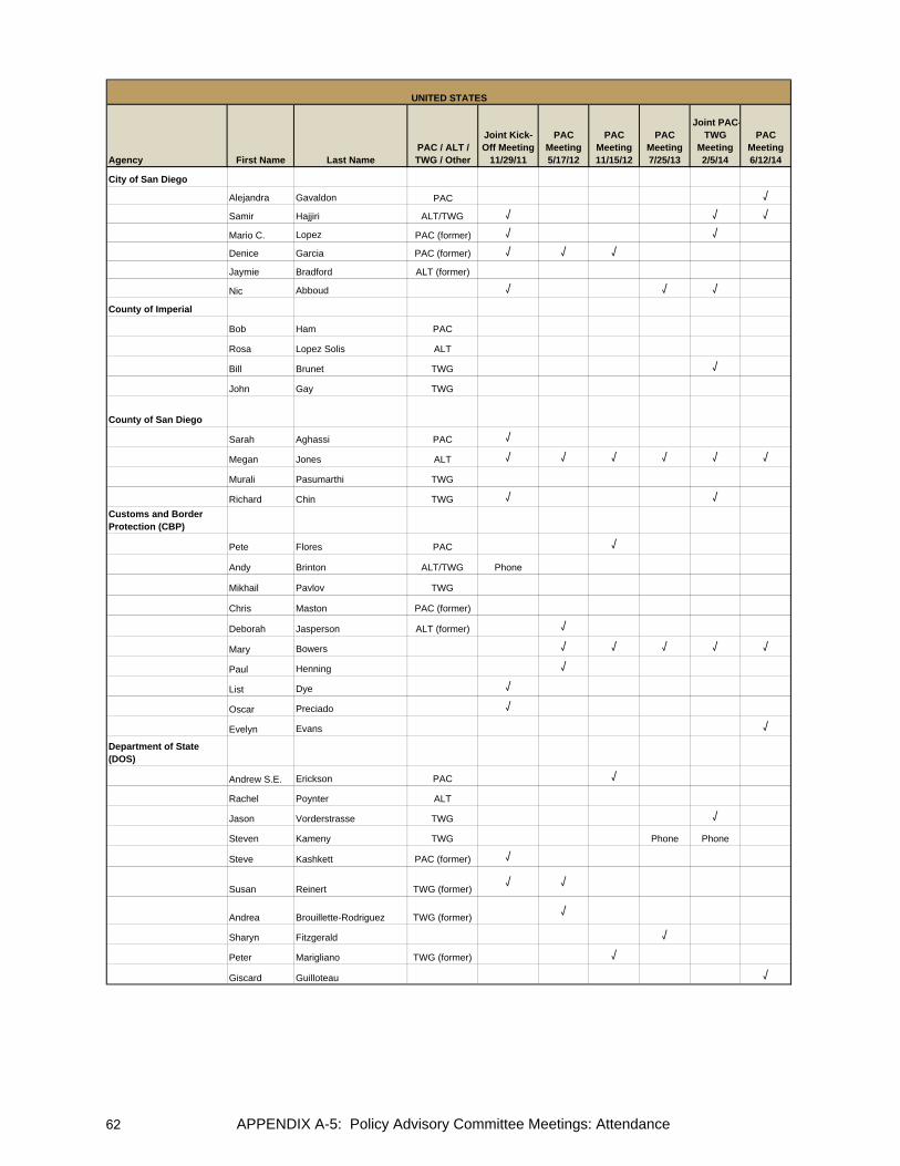
Agency First Name Last NamePAC / ALT / TWG / Other
Joint Kick-Off Meeting
11/29/11
PACMeeting 5/17/12
PAC Meeting 11/15/12
PAC Meeting 7/25/13
Joint PAC-TWG
Meeting 2/5/14
PAC Meeting 6/12/14
UNITED STATES
City of San Diego
Alejandra Gavaldon PAC √
Samir Hajjiri ALT/TWG √ √ √
Mario C. Lopez PAC (former) √ √
Denice Garcia PAC (former) √ √ √
Jaymie Bradford ALT (former)
Nic Abboud √ √ √
County of Imperial
Bob Ham PAC
Rosa Lopez Solis ALT
Bill Brunet TWG √
John Gay TWG
County of San Diego
Sarah Aghassi PAC √
Megan Jones ALT √ √ √ √ √ √
Murali Pasumarthi TWG
Richard Chin TWG √ √ Customs and Border Protection (CBP)
Pete Flores PAC √
Andy Brinton ALT/TWG Phone
Mikhail Pavlov TWG
Chris Maston PAC (former)
Deborah Jasperson ALT (former) √
Mary Bowers √ √ √ √ √
Paul Henning √
List Dye √
Oscar Preciado √
Evelyn Evans √
Department of State (DOS)
Andrew S.E. Erickson PAC √
Rachel Poynter ALT
Jason Vorderstrasse TWG √
Steven Kameny TWG Phone Phone
Steve Kashkett PAC (former) √
Susan Reinert TWG (former)√ √
Andrea Brouillette-Rodriguez TWG (former) √
Sharyn Fitzgerald √
Peter Marigliano TWG (former) √
Giscard Guilloteau √
APPENDIX A-5: Policy Advisory Committee Meetings: Attendance62

Agency First Name Last NamePAC / ALT / TWG / Other
Joint Kick-Off Meeting
11/29/11
PACMeeting 5/17/12
PAC Meeting 11/15/12
PAC Meeting 7/25/13
Joint PAC-TWG
Meeting 2/5/14
PAC Meeting 6/12/14
UNITED STATES
Environmental Protection Agency (EPA)
David FegePAC/TWG--Invited Party √
Federal Highway Administration (FHWA)
Sylvia Grijalva PAC √ √ √ √ √ √
Richard E. Backlund ALT/TWG √ √ √ √
Manuel SanchezALT/TWG (former) √ √ √ √
General Services Administration (GSA)
Abdee Gharavi PAC √ √
Ramon D. Riesgo ALT √ √ √ √ √
Anthony Kleppe TWG Phone √ √ Imperial County Transportation Commission (ICTC)
Mark Baza PAC √ √ √ √ √
Virginia Mendoza ALT/TWG
San Diego Association of Governments (SANDAG)
Gary Gallegos PAC √ √
Muggs Stoll ALT √ √ √ √
Rachel Kennedy TWG √ √
Christina Casgar √ √ √ √
Kim Kawada √
Hector Vanegas √ √ √
Southern California Association of Governments (SCAG)
Rich Macias PAC
Naresh Amatya ALT
Alan Thompson TWG
Mike Jones TWG √ Phone
Mike Ainsworth √ Phone
Margaret Lin √ Phone
Tomas Oliva Phone √
APPENDIX A-5: Policy Advisory Committee Meetings: Attendance 63

Agency First Name Last NamePAC / ALT / TWG / Other
Joint Kick-Off Meeting
11/29/11
PACMeeting 5/17/12
PAC Meeting 11/15/12
PAC Meeting 7/25/13
Joint PAC-TWG
Meeting 2/5/14
PAC Meeting 6/12/14
UNITED STATES
SANDAG Service Bureau
Elisa Arias √ √ √ √ √ √
Clint Daniels √ √
Andrea Hoff √ √ √ √
Cheryl Mason √ √ √ √ √ √
Joaquin Ortega √ √ √
Freslinda Vega √
Audomero Ruelas √
Smith Sonya √
Alfredo Medina √ √ √
APPENDIX A-5: Policy Advisory Committee Meetings: Attendance64

Agency First Name Last NamePAC / ALT / TWG / Other
Joint Kick-Off Meeting11/29/2011
PACMeeting 5/17/12
PAC Meeting 11/15/12
PAC Meeting 7/25/13
Joint PAC-TWG
Meeting 2/5/14
PAC Meeting 6/12/14
Consulate General of Mexico in San Diego
Remedios Gómez Arnau PAC √ √
Juan Carlos Rivas ALT/TWG √ √ √ √
Alberto DíazALT/TWG (former)
√ √
Francisco Javier Olavarría √
Elvira Felix √
General Customs Administration (Aduanas)
Alberto Morales Arechavaleta PAC Phone
Rogelio Sanchez Cruz ALT/TWG Phone
Alejandro Zamudio Gómez PAC (former)
Carlos Morales TayavasALT/TWG (former) √ √ √
General Customs Administration (Aduanas) - Tijuana
Alejandro Gonzales Guilbot PAC
Enrique Manjarrez Urarte ALT/TWG
Luis Alfonso Torres Torres PAC (former) √
Elva C. Santibañez ALT (former)
Angélica Echegoyen FloresALT/TWG (former)
√
CALIFORNIA-BAJA CALIFORNIA 2014 BMP UPDATE POLICY ADVISORY COMMITTEEParticipant Attendance Sheet
(agencies listed in alphabetical order)
MEXICO
APPENDIX A-5: Policy Advisory Committee Meetings: Attendance 65

Agency First Name Last NamePAC / ALT / TWG / Other
Joint Kick-Off Meeting11/29/2011
PACMeeting 5/17/12
PAC Meeting 11/15/12
PAC Meeting 7/25/13
Joint PAC-TWG
Meeting 2/5/14
PAC Meeting 6/12/14
MEXICO
Institute of Administration and Estimates of National Real Estate (INDAABIN)
Carlos de la Fuente PAC
Fernando Mas Roa ALT √ Phone
Fidel Castañeda Lugo TWG √ √
Salvador Lamas TWG √ √
Alejandro Zúñiga Camacho PAC (former) √
Luisa Fernanda Monica Herrera Martin ALT (former)
Victor David Ortiz√
Héctor Enrique De Dios Abascal √
Luis Enrique Mendez Ramirez √
Roberto Gámez Aguirre √
Metropolitan PlanningInstitute of Tijuana(IMPlan)
Daniel Rubio Díaz de la Vega PAC
Rodolfo Argote Gutiérrez ALT √ √
Oscar Cano Sauer TWG
Elias Sanz √
Municipal Planning Institute of Mexicali (IMIP)
Juventino Perez Brambila PAC √ √
Maria Adriana Macias Caballero ALT
Jesus Enrique Tapia Galindo TWG
Inocencio Cuellar López TWG (former)
Elias Paez √
Municipality of Mexicali
José Manuel Herrera de León ALT
Sylvia Quintero √
Municipality of Tecate
Gabriel Vázquez Murillo PAC
Ivonne Elena Anaya Gomez ALT/TWG √
Lorena Yanez Núñez √
Karen Aguilar Robledo √
APPENDIX A-5: Policy Advisory Committee Meetings: Attendance66

Agency First Name Last NamePAC / ALT / TWG / Other
Joint Kick-Off Meeting11/29/2011
PACMeeting 5/17/12
PAC Meeting 11/15/12
PAC Meeting 7/25/13
Joint PAC-TWG
Meeting 2/5/14
PAC Meeting 6/12/14
MEXICO
Municipality of Tijuana
Roberto Sánchez Martínez PAC
Antonio Cano ALT
Office of the Governor of Baja California
Mario Gerardo Herrera Zárate PAC
Mario Alberto Díaz Solís ALT/TWG √
Secretariat of Communications and Transportation (SCT)
Marco Antonio Frias Galvan PAC
Francisco Calvario ALT/TWG √ √ Phone Phone
Juan José Erazo García Cano PAC (former) √
Alberto Fernandez Obviedo PAC (former) Phone Phone
Secretariat of Social Development(SEDESOL)
José Luis Llovera Abreu PAC
Salvador Gómez Rocha ALT/TWG
Secretariat of Infrastructure and Urban Development (SIDUE)
Manuel Guevara Morales PAC
Germán Jesús Lizola Márquez ALT
Carlos López Rodríguez TWG √ √ √ √ √ √
Karlo Limon TWG √ √ √ √ √ √
Carlos Flores Vásquez PAC (former) √
Sergio E. Montes Montoya ALT (former) √
Juan Lopez √
America Robles √
APPENDIX A-5: Policy Advisory Committee Meetings: Attendance 67
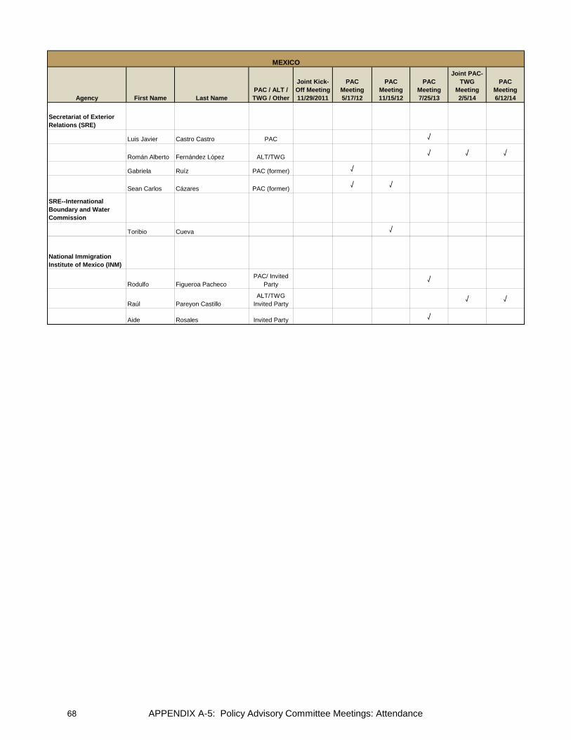
Agency First Name Last NamePAC / ALT / TWG / Other
Joint Kick-Off Meeting11/29/2011
PACMeeting 5/17/12
PAC Meeting 11/15/12
PAC Meeting 7/25/13
Joint PAC-TWG
Meeting 2/5/14
PAC Meeting 6/12/14
MEXICO
Secretariat of Exterior Relations (SRE)
Luis Javier Castro Castro PAC √
Román Alberto Fernández López ALT/TWG √ √ √
Gabriela Ruíz PAC (former) √
Sean Carlos Cázares PAC (former) √ √
SRE--International Boundary and Water Commission
Toribio Cueva √
National Immigration Institute of Mexico (INM)
Rodulfo Figueroa PachecoPAC/ Invited
Party√
Raúl Pareyon CastilloALT/TWG
Invited Party√ √
Aide Rosales Invited Party √
APPENDIX A-5: Policy Advisory Committee Meetings: Attendance68
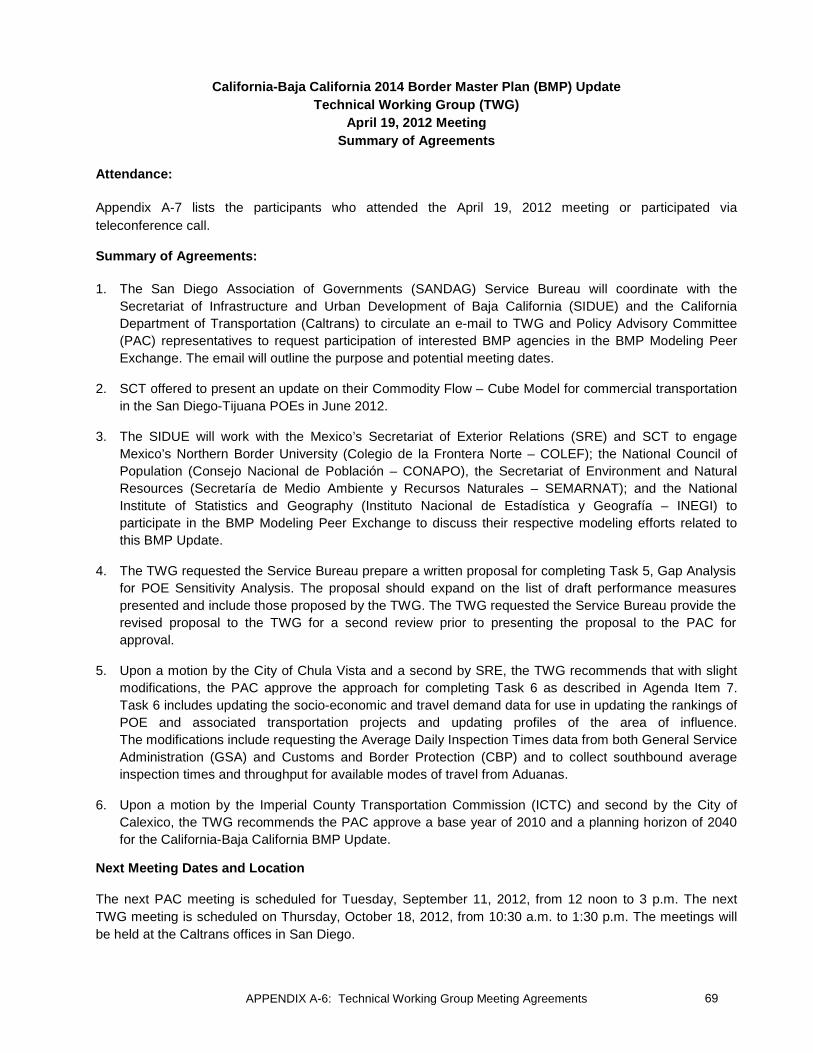
APPENDIX A-6: Technical Working Group Meeting Agreements
California-Baja California 2014 Border Master Plan (BMP) Update Technical Working Group (TWG)
April 19, 2012 Meeting Summary of Agreements
Attendance:
Appendix A-7 lists the participants who attended the April 19, 2012 meeting or participated via teleconference call. Summary of Agreements:
1. The San Diego Association of Governments (SANDAG) Service Bureau will coordinate with the Secretariat of Infrastructure and Urban Development of Baja California (SIDUE) and the California Department of Transportation (Caltrans) to circulate an e-mail to TWG and Policy Advisory Committee (PAC) representatives to request participation of interested BMP agencies in the BMP Modeling Peer Exchange. The email will outline the purpose and potential meeting dates.
2. SCT offered to present an update on their Commodity Flow – Cube Model for commercial transportation in the San Diego-Tijuana POEs in June 2012.
3. The SIDUE will work with the Mexico’s Secretariat of Exterior Relations (SRE) and SCT to engage Mexico’s Northern Border University (Colegio de la Frontera Norte – COLEF); the National Council of Population (Consejo Nacional de Población – CONAPO), the Secretariat of Environment and Natural Resources (Secretaría de Medio Ambiente y Recursos Naturales – SEMARNAT); and the National Institute of Statistics and Geography (Instituto Nacional de Estadística y Geografía – INEGI) to participate in the BMP Modeling Peer Exchange to discuss their respective modeling efforts related to this BMP Update.
4. The TWG requested the Service Bureau prepare a written proposal for completing Task 5, Gap Analysis for POE Sensitivity Analysis. The proposal should expand on the list of draft performance measures presented and include those proposed by the TWG. The TWG requested the Service Bureau provide the revised proposal to the TWG for a second review prior to presenting the proposal to the PAC for approval.
5. Upon a motion by the City of Chula Vista and a second by SRE, the TWG recommends that with slight modifications, the PAC approve the approach for completing Task 6 as described in Agenda Item 7. Task 6 includes updating the socio-economic and travel demand data for use in updating the rankings of POE and associated transportation projects and updating profiles of the area of influence. The modifications include requesting the Average Daily Inspection Times data from both General Service Administration (GSA) and Customs and Border Protection (CBP) and to collect southbound average inspection times and throughput for available modes of travel from Aduanas.
6. Upon a motion by the Imperial County Transportation Commission (ICTC) and second by the City of Calexico, the TWG recommends the PAC approve a base year of 2010 and a planning horizon of 2040 for the California-Baja California BMP Update.
Next Meeting Dates and Location
The next PAC meeting is scheduled for Tuesday, September 11, 2012, from 12 noon to 3 p.m. The next TWG meeting is scheduled on Thursday, October 18, 2012, from 10:30 a.m. to 1:30 p.m. The meetings will be held at the Caltrans offices in San Diego.
69

APPENDIX A-6: Technical Working Group Meeting Agreements
California-Baja California 2014 Border Master Plan (BMP) Update Technical Working Group (TWG) Meeting
August 2, 2012 Summary of Agreements
Attendance:
Appendix A-7 lists the participants who attended the August 2, 2012 meeting or participated via teleconference call.
Summary of Agreements:
1. The Secretariat of Communications and Transportation (SCT) agreed to share information with Caltrans and the SANDAG Service Bureau on the Intelligent Transportation Systems (ITS) being implemented in Mexico. SCT explained that this system will have a focus on northbound and southbound border crossings and also measure wait times and queue lengths. The TWG requested that the Service Bureau incorporate information received from SCT into the technical memo on the modeling effort.
2. It was announced that the Mexican agencies of the National Council of Population (Consejo Nacional de Población – CONAPO), the Secretariat of Environment and Natural Resources (Secretaría de Medio Ambiente y Recursos Naturales – SEMARNAT); and the National Institute of Statistics and Geography (Instituto Nacional de Estadística y Geografía – INEGI) and Mexico’s Northern Border University (Colegio de la Frontera Norte – COLEF) expressed a desire to review the demographics and socio-economic projections for Baja California. SCT will coordinate with the agencies to ensure their review occurs in a timely manner.
3. U.S. General Services Administration (GSA) agreed to provide documentation on the methodology GSA uses for forecasting bus and pedestrian crossing to Caltrans and the SANDAG Service Bureau within two weeks, so that Service Bureau can incorporate information into the gap analysis technical memo.
4. SCT recommended two additional indicators/measurements for developing “green facilities” and benchmarking energy consumption for existing and new Ports of Entry (POE) be incorporated into the BMP report. These proposed indicators/measurements are partially based on Leadership in Energy and Environmental Design (LEED) Certification strategies for clean energy usage and sustainability:
a. Of the total energy being consumed at each POE facility, what percentage is from “clean energy” sources such as solar?
b. Out of the total number of POE facilities in California and in Baja California, how many of the POEs are LEED certified?
The Institute of Administration and Estimates of National Real Estate (INDAABIN) and Aduanas stated that they believe that their agencies have the information to address these two criteria by POE and they will provide information to Caltrans and the SANDAG Service Bureau in two weeks. GSA stated that some information may be available for new POE facilities where energy surveys have been conducted. GSA stated that they will check to see if this information is available by POE and they will get back to Caltrans and the SANDAG Service Bureau.
70

APPENDIX A-6: Technical Working Group Meeting Agreements
In addition, INDAABIN, Aduanas, and GSA agreed to share energy strategies and/or energy plans for POEs.
The SANDAG Service Bureau will review the information from INDAABIN, Aduanas, and GSA and report back on how to incorporate the clean energy information into the BMP report at the next TWG meeting.
5. Due to lack of time, instead of presenting highlights for Agenda Item 5, Current and projected Demographic, Socio-economic, and Land Use Profile—DRAFT, the TWG agreed to review and provide comments, if needed.
6. Upon a motion from the City of Chula Vista and second by GSA the TWG agreed to use single estimates for the 2040 projections to be provided by Caltrans.
7. The TWG approved the cancellation of the September 11, 2012 Policy Advisory Committee (PAC) meeting. This will allow the Service Bureau time to clarify TWG responses to the questionnaires and collect missing information needed to present more complete technical memos to the TWG and PAC at the regularly scheduled meetings on October 18, and November 15, respectively. This additional time will also allow the Service Bureau to complete the tasks related to modeling efforts to present at these meetings.
8. The TWG expressed concerns about the border wait times data presented, as data were lower than those observed. The TWG agreed to give two weeks for the TWG representatives to provide input on how to address the issue of measuring northbound border wait times. The SANDAG Service Bureau will consider all input provided and show relative ranking of wait times at the POEs at the next meeting in October.
9. The U.S. Federal Highway Administration (FHWA) agreed to share the list of strategies, developed by the U.S.-Mexico Joint Working Committee (JWC), aimed at reducing border crossing wait times for TWG agencies to provide feedback.
Next Meeting Dates and Location:
The next TWG meeting is scheduled for Thursday, October 18, 2012, from 10:30 a.m. to 1:30 p.m. The next PAC meeting is scheduled on Thursday, November 15, 2012, from 10:30 a.m. to 1:30 p.m. (The September 11, 2012, PAC meeting has been canceled.) The meetings will be held at the Caltrans offices in San Diego.
71

APPENDIX A-6: Technical Working Group Meeting Agreements
California-Baja California 2014 Border Master Plan (BMP) Update Technical Working Group Meeting
October 18, 2012 Summary of Agreements
Attendance:
Appendix A-7 lists the participants who attended the October 18, 2012 meeting or participated via teleconference call.
Summary of Agreements:
1. Agenda Item 2, Approve TWG Meeting Agreements from August 2, 2012: The Technical Working Group (TWG) approved the August 2, 2012 meeting agreements as described in Agenda Item 2. (Secretariat of Foreign Relations (SRE)/U.S. Department of State (DOS))
2. Agenda Item 4, Review Approach for Task 7 – Updating Project Lists and Re-Ranking POE and Transportation Projects: The recommendations were as follows:
A. The TWG recommended the PAC approve the use of Option 4 methodology for ranking projects. Option 4 is a new option crafted by the TWG during the meeting. The flowchart for Option 4 is illustrated in Attachment 1. It includes both construction and funding screening criteria. The factors for Option 4 are listed below. (SRE/DOS)
a. The definition of short-, medium-, and long-term periods represents “date open to traffic.” b. Short-term projects are not ranked. c. Projects that are under construction at some point during the short-term period (2013-2014) will
not be ranked even if open to traffic date is after Dec. 31, 2014. d. Projects that are fully funded will not be ranked regardless of the time period.
B. The TWG recommended the PAC approve the definitions of short-term (2013-2014); medium-term (2015-2020); and long-term (2021-2040) time periods as outlined in Agenda Item 4. (City of Chula Vista/San Diego Association of Governments [SANDAG])
3. Agenda Item 5, Discuss Approach for Task 8 – Infrastructure Projects for Non-motorized Modes of Crossborder Travel: The TWG recommended the PAC approve the definition for non-motorized projects and proposed approach for incorporating these projects into the BMP Update, including cataloguing but not ranking the projects, with the following modification: Service Bureau to allow for other types of bicycle and pedestrian projects that were not specified in Agenda Item 5 to be submitted. (U. S. General Services Administration (GSA)/SANDAG)
4. Agenda item 6, Discuss Approach for Task 9 – Short-term Operational and Capital Investment Projects for Reducing Border Wait Times: The TWG recommended the PAC approve the definition of short-term operational and minor capital investment projects and the approach for conducting the work, including cataloguing but not ranking the projects, as described in Agenda Item 6. (GSA/SRE)
5. Agenda Item 7, Discuss Training on Web-based System for Updating Project Information: The TWG requested Caltrans and SIDUE postpone the technical training for using the Web-based data entry system from December 4 and 5, 2012 until early February 2013. The TWG felt that having the training in February would allow BMP agencies in Mexico time to finalize staff changes resulting from the transition to the new presidential administration. The TWG acknowledged that this would delay the project schedule.
72

APPENDIX A-6: Technical Working Group Meeting Agreements
6. Agenda Item 8, Discuss Task 5 – Updated Draft Analysis of a Future Model to Conduct POE Sensitivity Analysis: The TWG recommended the PAC accept the framework, performance measures, gap analysis, cost estimates, schedule, and recommendations regarding a future transportation demand model that could also perform sensitivity analyses as outlined in Agenda item 8, with the following modifications: Add a range around the cost estimate and add phasing to tasks outlined in the schedule. (SRE/GSA)
7. Agenda Item 9, Discuss Task 6 – Updated Draft on Existing POE Capacity and Travel Demand and Border Wait Times. The recommendations were as follows:
A. The TWG recommended the PAC: (GSA/SANDAG)
a. Accept the data and information for use in the POE profiles
b. Accept the northbound travel demand estimates for 2010 and 2040 for use in the evaluation criteria for ranking projects
c. Accept the northbound value and volume of trade data for use in the evaluation criteria for ranking projects
B. The TWG recommended the PAC approve the use of the POE relative order of northbound border wait times in the evaluation criteria for ranking projects. (DOS/City of Calexico)
8. Agenda Item 10, Discuss Task 6 – Updated Draft on Current and Projected Socio-Economic and Land Use Profiles. The TWG did not make a recommendation on this item, but rather, the data and information will be included in the draft BMP report and approved as part of the report at a later date.
Next Meeting Dates and Location:
The next PAC meeting is scheduled for Thursday, November 15, 2012, from 10:30 a.m. to 1:30 p.m. The meeting will be held at the Caltrans offices in San Diego.
73

APPENDIX A-6: Technical Working Group Meeting Agreements
Attachment 1
California-Baja California 2014 Border Master Plan (BMP) Update Flowchart for Option 4 Approach for Ranking Projects Construction and Funding Screening Criteria Applied
74

APPENDIX A-6: Technical Working Group Meeting Agreements
California-Baja California Border Master Plan (BMP) Update Technical Working Group (TWG) Meeting
February 27, 2013 Summary
Attendance:
Appendix A-7 lists the participants who attended the February 27, 2013, meeting or participated via teleconference call.
TWG representatives were encouraged to invite staff who may assist with project entry to participate in the meeting and training session either in person or via teleconferencing and Webinar services.
Summary:
• A review of the evaluation criteria used for ranking Port of Entry (POE) and related transportation projects was presented.
• Training on the Online Data Management Portal for entering POE and related transportation projects was provided. Two training sessions were conducted—one in English and one in Spanish.
• TWG representatives were requested to submit projects using the Online Data Management Portal by Friday, March 29, 2013. After the cut-off date, the Service Bureau would download all projects and rank them according to the approved evaluation criteria.
• User manuals in English and Spanish were provided at the training sessions and were emailed to all TWG representatives. User Guides are also available on the Web Portal under the “Reports and Resources” tab.
Follow up:
• SANDAG Service Bureau will email agency-specific user names and passwords for accessing the Web Portal to all TWG representatives.
Next Meeting Dates and Location:
The next TWG meeting is scheduled for Thursday, June 20, 2013. The next PAC meeting is scheduled for Thursday, July 25, 2013. Meeting times are from 10:30 a.m. to 1:30 p.m. The meetings will be held at the Caltrans offices in San Diego.
75
APPENDIX A-6: Technical Working Group Meeting Agreements
California-Baja California 2014 Border Master Plan (BMP) Update Technical Working Group (TWG)
June 20, 2013 Meeting Summary of Agreements
Attendance:
Appendix A-7 lists the participants who attended the June 20, 2013 meeting or participated via conference call.
Meeting Summary and Agreements:
The San Diego Association of Governments (SANDAG) Service Bureau presented the rankings of medium- and long-term Port of Entry (POE) and connecting transportation projects for roadway, interchange, and rail improvements. The rankings were produced in accordance with the evaluation criteria and methodology approved at the Policy Advisory Committee (PAC) meeting on November 15, 2012. The Service Bureau reviewed the findings, which included a review of whether planning and implementation of POE and connecting transportation facilities appeared to be taking place in a coordinated manner or whether there were gaps in reported project schedules.
In addition, the Service Bureau summarized listings of projects that were not ranked through the BMP Update, which include short-term projects, fully funded projects1, projects under construction, non-motorized projects, and short-term operational and minor capital investment projects to reduce cross border wait times.
Following are the agreements from the meeting:
1. The California Department of Transportation (Caltrans) and the Secretariat of Communications and Transportation (SCT) agree to harmonize the Otay Mesa East – Mesa de Otay II POE project schedule and coordinate the date for both facilities to Open to Traffic. Mexico’s SRE noted that there was no need for both countries to exchange Diplomatic Notes in this regard.
2. The Secretariat of Infrastructure and Urban Development of Baja California (SIDUE) agrees to contact the Municipal Planning Institute of Mexicali (IMIP) to request they provide information on the Bus Rapid Transit (BRT) project that provides connectivity between Mexicali I POE and Mexicali II POE. This project will not be ranked and will be included on one of the short-term projects lists.
3. The General Services Administration (GSA) agrees to provide information on the proposed northbound and southbound pedestrian crossing at Virginia Avenue and associated intermodal transportation center. This project will not be ranked and will be included on one of the short-term project lists.
4. SANDAG Service Bureau agrees to upload all of the project maps onto the BMP Web site. The TWG agrees to review the maps for accuracy and give feedback, if any, to the Service Bureau within a week.
1 At the request of the PAC, the Service Bureau would create a second list that ranks fully funded projects. The purpose of this list is to demonstrate the ranking of projects to be used in case a project loses funding and new efforts are needed to pursue lost funding. This list will be included in the appendix of the final report and will be referred to as BMP 2014 Expanded List of Ranked Projects (including Funded and Not Funded Projects).
76

APPENDIX A-6: Technical Working Group Meeting Agreements
5. Upon a motion by City of Calexico and second by GSA, the TWG recommended the PAC approve the following: a. POE project rankings for new POEs b. POE project rankings for the modernization of existing POEs c. Ranking of roadway, interchange, and rail projects associated with POEs
Next Meeting Dates and Location
The next PAC meeting is scheduled for Thursday, July 25, 2013, from 10:30 a.m. to 1:30 p.m. The meeting will be held at the Caltrans District Offices in San Diego, California.
77

APPENDIX A-6: Technical Working Group Meeting Agreements
California-Baja California 2014 Border Master Plan (BMP) Update Technical Working Group Meeting (TWG)
April 10, 2014 Summary of Agreements
Attendance: Appendix A-7 lists the participants who attended the June 20, 2013 meeting or participated via conference call. Objectives of the Meeting:
Review Draft California-Baja California 2014 BMP Update Report including highlights of the major tasks, findings, and recommendations. The TWG is asked to provide verbal agreements at this meeting and written comments on the draft to the Service Bureau by April 25, 2014.
Summary of Agreements:
1. The TWG recommended that the Policy Advisory Committee (PAC) approve the California-Baja California 2014 BMP Update report, which will address today’s agreements and those written comments to be provided by the TWG by April 25, 2014.
[Motion by City of Chula Vista/ Second by City of Calexico]
2. Based on a suggestion by the Federal Highway Administration (FHWA), the TWG recommended that California Department of Transportation (Caltrans) and Secretariat of Infrastructure and Urban Development (SIDUE) include a letter signed by the directors of Caltrans District 11 and SIDUE, in the final BMP report to thank the BMP agencies for their participation and highlight the importance of the BMP effort.
3. SIDUE will submit two rail projects that were omitted during the project submission phase. These projects will be added to the BMP Project Inventory List. They will be catalogued only and will not be ranked. The first project is a trolley line for passenger service in a segment between the cities of Tijuana and Tecate. The second project is a freight rail project connecting the Tijuana-Tecate railroad line to El Sauzal, in the Municipality of Ensenada. Both projects will initially be shown as dashed lines on the maps. With PAC concurrence, the dashed lines will be converted to solid lines for the final report. The technical data for these projects will be included in the Appendix and the projects will be listed in the report. These two projects are included in various planning documents in Mexico, which is a pre-requisite for submitting projects.1
4. The TWG supported the proposal from Caltrans and SIDUE to invite the North American Development Bank (NADBANK) to the next BMP PAC meeting. Caltrans will invite a NADBANK representative.
1 Both projects are included in the Programa de Ordenamiento Territorial de la Zona Metropolitana Tijuana-Playas de Rosarito-Tecate y Ensenada, 2012 and the Plan Estratégico de Baja California, 2013-2019. In addition, the passenger train in Tijuana (trolley) also is included in the Programa de Desarrollo Urbano de Centro de Población de Tijuana; 2010. The Tecate - Ensenada rail line also is included in the Plan Estatal de Desarrollo Urbano de Baja California, 2010.
78
APPENDIX A-6: Technical Working Group Meeting Agreements
5. The TWG supported the proposal from SIDUE to invite the Secretariat of Agrarian, Territorial and Urban Development (SEDATU) to the next BMP PAC meeting. In addition, because the planning responsibilities have moved from the Secretariat of Social Development (SEDESOL) to SEDATU, SIDUE will request the PAC replace SEDESOL with SEDATU as a participating BMP agency for future BMP updates. This proposal will be discussed at the next PAC meeting.
6. Based on a suggestion by the Metropolitan Planning Institute of Tijuana (IMPlan), the TWG requested that Caltrans and SIDUE explore the possibility of obtaining an acknowledgement from the California and Baja California state governments on the California-Baja California BMP effort.
7. County of San Diego requested that the interchange at SR-125 and Lonestar be reassigned from the Otay Mesa – Mesa de Otay Port of Entry (POE) to the new proposed Otay Mesa East – Mesa de Otay II POE.
8. Caltrans and SIDUE will invite interested BMP agencies to participate in an ad hoc work group to develop a process to make the California-Baja California BMP a living document.
Next Meeting Dates and Location The next PAC meeting is scheduled for Tuesday, June 12, 2014 from 10:30 a.m. to 1:30 p.m. Meeting will be held at the Caltrans offices in San Diego. The PAC will be asked to approve the California-Baja California 2014 BMP report at this meeting.
79

This page intentionally left blank

Agency First Name Last NamePAC / ALT / TWG / Other
TWG Meeting
4/19/2012
TWG Meeting 8/2/12
TWG Meeting 10/18/12
TWG Meeting 2/27/13
TWG Meeting 6/20/13
TWG Meeting 4/10/14
California Department of Transportation (Caltrans)
Laurie Berman PAC
Bill Figge ALT √ √ √ √ √ √
Sergio Pallares TWG √ √ √ √ √ √
Anthony Aguirre √ √ √
Mario Orso √
Maurice Eaton √ √
Pat Landrum √ √ √
Roger Sanchez-Rangel √ √ √
Jose Marquez √ √ √
City of Calexico
Oscar Rodriquez PAC
Nick Servin ALT/TWG √ √ √ √
Nick Fenley √
Alejandro Espinoza TWG (former) √
City of Chula Vista
Gary Halbert PAC
Tom Adler ALT √ √
David Kaplan TWG √ √ √ √ √ √
City of El Centro
Ruben Duran PAC
Abraham Campos ALT/ TWG
City of Holtville
Alexander Meyerhoff PAC
Nick Wells ALT/ TWG
City of Imperial Beach
Gary Brown PAC
Greg Wade ALT/ TWG
City of National City
Leslie Deese PAC
Steve Manganiello ALT/ TWG
Kenneth Fernandez TWG √ √ √ √ √
CALIFORNIA-BAJA CALIFORNIA 2014 BMP UPDATE TECHNICAL WORKING GROUP MEETINGS Participant Attendance Sheet
(agencies listed in alphabetical order)
UNITED STATES
APPENDIX A-7: Technical Working Group Meetings: Attendance 81
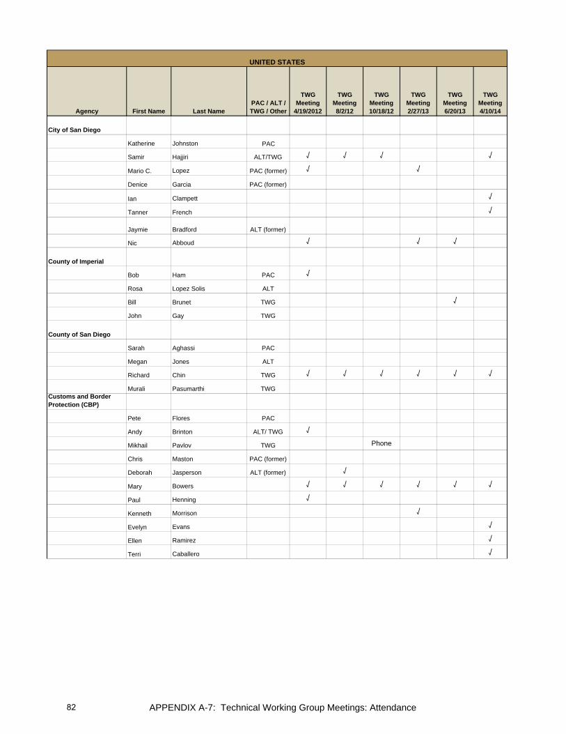
Agency First Name Last NamePAC / ALT / TWG / Other
TWG Meeting
4/19/2012
TWG Meeting 8/2/12
TWG Meeting 10/18/12
TWG Meeting 2/27/13
TWG Meeting 6/20/13
TWG Meeting 4/10/14
UNITED STATES
City of San Diego
Katherine Johnston PAC
Samir Hajjiri ALT/TWG √ √ √ √
Mario C. Lopez PAC (former) √ √
Denice Garcia PAC (former)
Ian Clampett √
Tanner French √
Jaymie Bradford ALT (former)
Nic Abboud √ √ √
County of Imperial
Bob Ham PAC √
Rosa Lopez Solis ALT
Bill Brunet TWG √
John Gay TWG
County of San Diego
Sarah Aghassi PAC
Megan Jones ALT
Richard Chin TWG √ √ √ √ √ √
Murali Pasumarthi TWGCustoms and Border Protection (CBP)
Pete Flores PAC
Andy Brinton ALT/ TWG √
Mikhail Pavlov TWG Phone
Chris Maston PAC (former)
Deborah Jasperson ALT (former) √
Mary Bowers √ √ √ √ √ √
Paul Henning √
Kenneth Morrison √
Evelyn Evans √
Ellen Ramirez √
Terri Caballero √
APPENDIX A-7: Technical Working Group Meetings: Attendance82
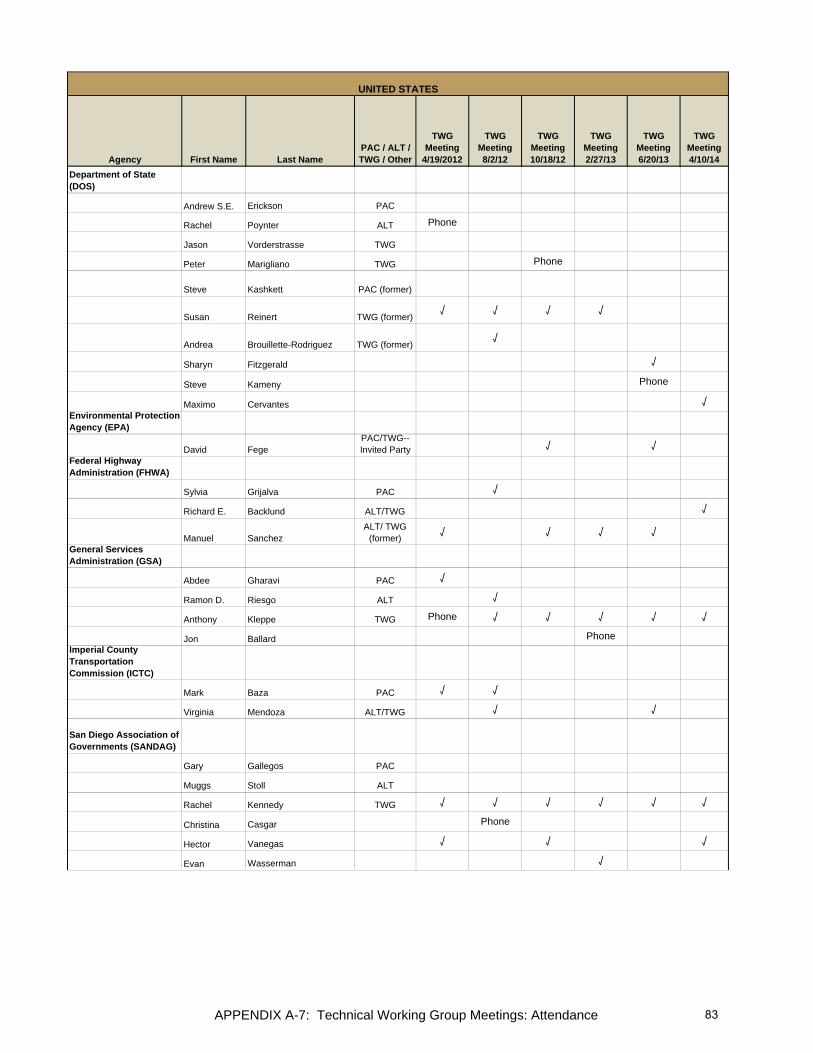
Agency First Name Last NamePAC / ALT / TWG / Other
TWG Meeting
4/19/2012
TWG Meeting 8/2/12
TWG Meeting 10/18/12
TWG Meeting 2/27/13
TWG Meeting 6/20/13
TWG Meeting 4/10/14
UNITED STATES
Department of State (DOS)
Andrew S.E. Erickson PAC
Rachel Poynter ALT Phone
Jason Vorderstrasse TWG
Peter Marigliano TWG Phone
Steve Kashkett PAC (former)
Susan Reinert TWG (former) √ √ √ √
Andrea Brouillette-Rodriguez TWG (former) √
Sharyn Fitzgerald √
Steve Kameny Phone
Maximo Cervantes √Environmental Protection Agency (EPA)
David FegePAC/TWG--Invited Party √ √
Federal Highway Administration (FHWA)
Sylvia Grijalva PAC √
Richard E. Backlund ALT/TWG √
Manuel SanchezALT/ TWG
(former) √ √ √ √ General Services Administration (GSA)
Abdee Gharavi PAC √
Ramon D. Riesgo ALT √
Anthony Kleppe TWG Phone √ √ √ √ √
Jon Ballard PhoneImperial County Transportation Commission (ICTC)
Mark Baza PAC √ √
Virginia Mendoza ALT/TWG √ √
San Diego Association of Governments (SANDAG)
Gary Gallegos PAC
Muggs Stoll ALT
Rachel Kennedy TWG √ √ √ √ √ √
Christina Casgar Phone
Hector Vanegas √ √ √
Evan Wasserman √
APPENDIX A-7: Technical Working Group Meetings: Attendance 83

Agency First Name Last NamePAC / ALT / TWG / Other
TWG Meeting
4/19/2012
TWG Meeting 8/2/12
TWG Meeting 10/18/12
TWG Meeting 2/27/13
TWG Meeting 6/20/13
TWG Meeting 4/10/14
UNITED STATES
Southern California Association of Governments (SCAG)
Rich Macias PAC
Naresh Amatya ALT
Alan Thompson TWG √ Phone
Mike Jones TWG Phone
Margaret Lin Phone
Tomas Oliva √ √
SANDAG Service Bureau
Elisa Arias √ √ √ √ √
Clint Daniels √ √ √
Andrea Hoff √ √ √ √ √
Cheryl Mason √ √ √ √ √ √
Joaquin Ortega √ √ √
Andy Gordon √
Audomero Ruelas √ √
Smith Sonya √ √
Alfredo Medina √ √ √ √
APPENDIX A-7: Technical Working Group Meetings: Attendance84

Agency First Name Last NamePAC / ALT / TWG / Other
TWG Meeting
4/19/2012
TWG Meeting 8/2/12
TWG Meeting 10/18/12
TWG Meeting 2/27/13
TWG Meeting 6/20/13
TWG Meeting 4/10/14
Consulate General of Mexico in San Diego
Remedios Gómez Arnau PAC √
Juan Carlos Rivas ALT/TWG √ √ √ √ √
Alberto DíazALT/TWG (former) √
General Customs Administration (Aduanas)
Alejandro Zamudio Gómez PAC
Alberto Morales Arechavaleta PAC (former)
Carlos Morales TayavasALT/TWG (former) √ √ √
General Customs Administration (Aduanas) - Tijuana
Alejandro Gonzales Guilbot PAC
Enrique Manjarrez Urarte ALT/TWG
Luis Alfonso Torres Torres PAC (former) √
Elva C. Santibañez ALT (former) √
Angélica Echegoyen FloresALT/TWG (former)
Institute of Administration and Estimates of National Real Estate (INDAABIN)
Carlos de la Fuente PAC
Fernando Mas Roa ALT
Fidel Castañeda Lugo TWG √ √ √
Salvador Lamas TWG √ √
Alejandro Zúñiga Camacho PAC (former)Luisa Fernanda Monica Herrera Martin ALT (former)
Héctor Enrique De Dios Abascal √
Guillermo Villagómez √
Roberto Gámez Aguirre √
CALIFORNIA-BAJA CALIFORNIA 2014 BMP UPDATE TECHNICAL WORKING GROUP Participant Attendance Sheet
(agencies listed in alphabetical order)
MEXICO
APPENDIX A-7: Technical Working Group Meetings: Attendance 85

Agency First Name Last NamePAC / ALT / TWG / Other
TWG Meeting
4/19/2012
TWG Meeting 8/2/12
TWG Meeting 10/18/12
TWG Meeting 2/27/13
TWG Meeting 6/20/13
TWG Meeting 4/10/14
MEXICO
Metropolitan PlanningInstitute of Tijuana(IMPlan)
Daniel Rubio Díaz de la Vega PAC
Rodolfo Argote Gutiérrez ALT √ √
Oscar Cano Sauer TWG √
Francisco Pujol Domínguez TWG (former)
Fausto Armenta √
Elias Sanz √
Municipal Planning Institute of Mexicali (IMIP)
Juventino Perez Brambila PAC √
Maria Adriana Macias Caballero ALT
Jesus Enrique Tapia Galindo TWG √
Inocencio Cuellar López TWG (former)
Elias Paez √ √Phone
(Training)
Eduardo Raya √
Municipality of Mexicali
José Manuel Herrera de León ALT
Municipality of Playas de Rosarito
César Villegas Campoy PAC
Municipality of Tecate
Karla Ivonne Moreno Precido PAC
Ivonne Anaya ALT/TWG √
Gabriel Vázquez Murillo PAC (former) √
Municipality of Tijuana
Roberto Sánchez Martínez PAC
Antonio Cano ALT
APPENDIX A-7: Technical Working Group Meetings: Attendance86

Agency First Name Last NamePAC / ALT / TWG / Other
TWG Meeting
4/19/2012
TWG Meeting 8/2/12
TWG Meeting 10/18/12
TWG Meeting 2/27/13
TWG Meeting 6/20/13
TWG Meeting 4/10/14
MEXICO
Office of the Governor of Baja California
Mario Gerardo Herrera Zárate PAC
Mario Alberto Díaz Solís ALT/TWG
Secretariat of Communications and Transportation (SCT)
Marco Antonio Frias Galvan PAC √ √
Francisco Calvario ALT/TWG √ √ √ √ Phone
Juan José Erazo García Cano PAC (former) √ √
Alberto Fernandez Obviedo PAC (former) √
Humberto Nicolas √
Secretariat of Social Development(SEDESOL)
José Luis Llovera Abreu PAC
Salvador Gómez Rocha ALT/TWG
Secretariat of Infrastructure and Urban Development (SIDUE)
Manuel Guevara Morales PAC
Germán Jesús Lizola Márquez ALT
Carlos López Rodríguez TWG √ √ √
Karlo Limon TWG √ √ √ √
Carlos Flores Vásquez PAC (former)
Sergio E. Montes Montoya ALT (former)
Secretariat of ExteriorRelations(SRE)
Luis Javier Castro Castro PAC
Román Alberto Fernández López ALT/TWGPhone
(Training)
Gabriela Ruíz PAC (former) √ √ √ √
Sean Carlos Cázares PAC (former) √ √ √ √
APPENDIX A-7: Technical Working Group Meetings: Attendance 87

Agency First Name Last NamePAC / ALT / TWG / Other
TWG Meeting
4/19/2012
TWG Meeting 8/2/12
TWG Meeting 10/18/12
TWG Meeting 2/27/13
TWG Meeting 6/20/13
TWG Meeting 4/10/14
MEXICO
SRE--International Boundary and Water Commission
Toribio Cueva
National Immigration Institute of Mexico (INM)
Rodulfo Figueroa PachelcoPAC/ Invited
Party
Raúl Pareyon CastilloALT/TWG
Invited Party
Aide Rosales Invited Party √
APPENDIX A-7: Technical Working Group Meetings: Attendance88

APPENDIX A-8: Transportation Modeling Focus Group (January 18, 2012)
California-Baja California Border Master Plan Update January 18, 2012
Focus Group: BMP Modeling Efforts Summary of Discussion
Participants
The list of the participants who attended the BMP Modeling focus group meeting or participated via teleconference call is included in Attachment A.
Agenda:
The January 18, 2012 focus group meeting agenda is included in Attachment B.
Meeting Objectives
Meeting objectives were:
• Discuss and consider establishing a peer exchange process so technical experts could work together to assist in development of BMP modeling efforts (objective added during the meeting).
• Discuss and agree on the vision of the modeling tasks for the BMP Update, including POE sensitivity analysis, for development of a framework for future refinements to transportation and POE modeling tools for border transportation infrastructure.
• Increase the understanding of existing transportation and POE models, data, and analyses applicable to the border.
Summary of Discussion
• The Modeling Focus Group discussed the importance of forming a peer exchange to share information about the regional transportation related modeling efforts on both sides of the border. Discussion on the need to create of a peer exchange group to assist in the BMP’s modeling effort. Given the scope and limited budget of this project, the peer exchange would include technical experts in the California and Baja California border region and would focus on the modeling framework for the BMP Update.
• The Service Bureau presented the following preliminary definition of sensitivity analysis for the BMP Update and initial framework for conducting the POE sensitivity analysis:
o Sensitivity analysis is defined as a tool that could help assess the impact and elasticity in the capacities of POE and transportation infrastructure investments. The sensitivity analysis would be a model that allows one to study how investments in one POE affect investments in another POE within the same metropolitan area.
o Potential framework: Focus would be primarily on the California-Baja California POEs, Secondly, this effort would highlight major transportation facilities that provide access to the POEs (major east-west and north-south transportation facilities). Finally, transit and non-motorized modes of transportation would be considered.
• The Service Bureau presented an overview of existing transportation and POE models along the California-Baja California border. The Secretariat of Communications and Transportation (SCT) informed the group, they have a model framework under development that includes a model called Cube Cargo (with economic forecasts produced by Global Insight). SCT stated that their agency’s current focus is on the cargo modeling side but that a model focusing on the passenger vehicle side could be developed in the future if resources were available. SCT felt that these models could help the BMP modeling effort move toward a POE sensitivity analysis. SCT agreed
89

APPENDIX A-8: Transportation Modeling Focus Group (January 18, 2012)
to send/or present an executive summary of the SCT Cube Cargo and other models such as Cube Dynasim, and network layers in ArcGIS to Caltrans/SANDAG Service Bureau.
• The group invited SCT to meet for a technical discussion of the specific capabilities of the SCT models in February. This meeting has been set for 2/28/2012 in San Diego. .
• SANDAG offered to share data in a peer exchange process so that other agencies have an understanding of SANDAG sources.
• Service Bureau will update the matrix (attached to the agenda) to include new information about SCT’s models and also new information from IMPLAN-Mexicali models.
• Focus group representatives provided the following input/feedback on the sensitivity analysis modeling effort for the BMP effort:
o The framework of a future sensitivity analysis model should include impacts of queuing near POEs on arterials not just major transportation facilities and impacts to local communities (including transit) not just POE impacts.
o The future model should include binational Peer Exchange and Peer Review processes on model inputs/outputs, common language, common dataset and assumptions. It was emphasized that although the countries should respect their individual modeling processes, it is beneficial to share information and use similar data, if possible. The group also discussed the possibility of looking into an independent third party peer review of data sources from both countries, should this be considered beneficial.
o Both parties need to agree on scenarios that could influence the economic outlook and flows between the countries, including, but not limited to border crossing of people and freight, infrastructure improvements and forecasted demand on the POE (motorized and non-motorized, mass transit), and data sources, and performance measures, and other technical elements as needed..
o Cooperation and possible agreement on data protocols or common set of data that are of common interest is an important aspect of a sustainable long-term binational modeling process.
Next Steps
1. This summary of the Focus Group will be emailed to all BMP agencies 2. SCT will present the Cube Models reference above at the SANDAG offices in San Diego
(subsequently scheduled for February 28, 2012 from 10:00 A.M. to 12:00 Noon.) 3. The next regularly scheduled BMP Technical Working Group meeting is scheduled for Thursday,
April 19, 2012 from 10:30 a.m. to 1:30 p.m. 4. The next regularly scheduled BMP Policy Advisory Committee meeting is scheduled for
Thursday, May 17, 2012 from 10:30 a.m. to 1:30 p.m.
The regularly scheduled BMP meetings (3 and 4 above) will be held at Caltrans in San Diego.
(Summary Prepared 2-28-2012)
90

Ag
ency
Firs
t N
ame
Last
Nam
ePA
C/
ALT
/TW
GA
dd
ress
1A
dd
ress
2C
ity
STZi
p C
od
ePh
on
e
Emai
l
1/18
/12
Mo
del
ing
Fo
cus
Gro
up
CBP
Mar
yBo
wer
s
Cus
tom
s an
d Bo
rder
Pr
otec
tion
2400
0 Av
ila R
oad,
R
oom
502
0La
guna
Nig
uelC
A92
677
(949
) 360
-238
3m
ary.
a.bo
wer
s.cb
p.dh
s.go
vX
CBP
Andy
Brin
ton
TWG
CBP
Offi
ce o
f Fie
ld
Ope
ratio
ns, S
an
Die
go F
ield
Offi
ce61
0 W
. Ash
Stre
et,
Suite
120
0Sa
n D
iego
CA
9210
1(6
19) 6
52-9
966
x141
wal
ter.b
rinto
n@dh
s.go
vP
HO
NE
CBP
Mik
hail
Pavl
ovTW
GC
usto
ms
and
Bord
er
Prot
ectio
n17
17 H
Stre
et N
W,
Suite
800
Was
hing
ton
DC
2000
6(2
02) 3
25-7
015
mik
hail.
a.pa
vlov
@cb
p.dh
s.go
vX
FHW
AM
anue
lSa
nche
zAL
T
Uni
ted
Stat
es
Dep
artm
ent o
f Tr
ansp
orta
tion
401
B St
reet
, Sui
te
800
San
Die
goC
A92
101
(619
) 699
-733
6m
anue
l.san
chez
@do
t.gov
X
GSA
Abde
eG
hara
viPA
CSo
uthe
rn B
orde
r St
atio
n C
ente
r 45
0 G
olde
n G
ate
Ave.
9P
San
Fran
cisc
oC
A94
102
(415
) 522
-308
5ab
dee.
ghar
avi@
gsa.
gov
PH
ON
E
GSA
Anth
ony
Klep
peTW
GG
SA S
outh
ern
Bord
er
Stat
ion
Cen
ter
450
Gol
den
Gat
e Av
e. 9
PSa
n Fr
anci
sco
CA
9410
2(4
15) 5
22-3
442
/ (4
15) 5
22-3
474
anth
ony.
klep
pe@
gsa.
gov
PH
ON
E
Cal
trans
Mau
rice
Eato
nC
altra
ns D
istri
ct 1
140
50 T
aylo
r Stre
etSa
n D
iego
CA
9211
0(6
19) 6
88-3
137
mau
rice_
eato
n@do
t.ca.
gov
X
Cal
trans
Pat
Land
rum
Cal
trans
Dis
trict
11,
G
eosp
atia
l In
form
atio
n Sy
stem
s40
50 T
aylo
r Stre
etSa
n D
iego
CA
9211
0(6
19) 6
88-6
476
pat.j
.land
rum
@do
t.ca.
gov
X
Cal
trans
Serg
ioPa
llare
sTW
GC
altra
ns D
istri
ct 1
1 40
50 T
aylo
r Stre
etSa
n D
iego
CA
9211
0(6
19) 6
88-3
610
serg
io.p
alla
res@
dot.c
a.go
v X
SCAG
Mar
gare
tLi
n(2
13) 2
36-1
866
lin@
scag
.ca.
gov
PHO
NE
SAN
DAG
Wu
Sun
SAN
DAG
401
B St
reet
, Sui
te
800
San
Die
goC
A92
101
(619
)699
-575
7w
su@
sand
ag.o
rg
X
SAN
DAG
Hec
tor
Vane
gas
SAN
DAG
401
B St
reet
, Sui
te
800
San
Die
goC
A92
101
(619
)699
-197
2hv
a@sa
ndag
.org
X
Cou
nty
of S
an
Die
goR
icha
rdC
hin
TWG
Cou
nty
of S
an D
iego
O
pera
tions
Cen
ter
5469
Kea
rny
Villa
R
d., S
uite
201
San
Die
goC
A92
123
(858
) 874
-489
8ric
hard
.chi
n@sd
coun
ty.c
a.go
v X
CA
LIFO
RN
IA-B
AJA
CA
LIFO
RN
IA 2
011/
12 B
OR
DER
MA
STER
PLA
N U
PDA
TE
FOC
US
GR
OU
P: B
MP
MO
DEL
ING
EFF
OR
TS--
JAN
UA
RY
18,
201
2
UN
ITED
STA
TES
APPENDIX A-8: Transportation Modeling Focus Group (January 18, 2012)
ATTACHMENT A
91
Ag
ency
Firs
t N
ame
Last
Nam
ePA
C/
ALT
/TW
GA
dd
ress
1A
dd
ress
2C
ity
STZi
p C
od
ePh
on
e
Emai
l
1/18
/12
Mo
del
ing
Fo
cus
Gro
up
CA
LIFO
RN
IA-B
AJA
CA
LIFO
RN
IA 2
011/
12 B
OR
DER
MA
STER
PLA
N U
PDA
TE
FOC
US
GR
OU
P: B
MP
MO
DEL
ING
EFF
OR
TS--
JAN
UA
RY
18,
201
2
City
of S
an
Die
goSa
mir
Haj
jiri
TWG
City
of S
an D
iego
1222
Firs
t Av,
MS
413
San
Die
goC
A92
101
(619
) 533
-655
1sh
ajjir
i@sa
ndie
go.g
ov
X
City
of C
hula
Vi
sta
Dav
idKa
plan
TWG
City
of C
hula
Vis
ta27
6 Fo
urth
Ave
nue
Chu
la V
ista
CA
9191
0(6
19) 6
91-5
025
dkap
lan@
ci.c
hula
-vis
ta.c
a.us
X
Cou
nty
of
Impe
rial
Bob
Ham
PAC
Cou
nty
of Im
peria
l94
0 W
. Mai
n #2
08El
Cen
troC
A92
243
(760
) 482
-428
2bo
bham
@co
.impe
rial.c
a.us
X
SCT
Juan
Jos
é Er
azo
Gar
cía
Can
oPA
CSC
T
gC
ol. N
oche
buen
aD
eleg
. Ben
ito J
uáre
z,
Piso
10
Mex
ico
D.F
.03
720
(55)
54
82 4
3 67
jera
zog@
sct.g
ob.m
xPH
ON
E
SCT
Fran
cisc
oC
alva
rioAL
TSC
T
gC
ol. N
oche
buen
aD
eleg
. Ben
ito J
uáre
z,
Piso
10
Mex
ico
D.F
.03
720
(55)
54
82 4
2 00
ex
t.160
57 fc
alva
ri@sc
t.gob
.mx
PHO
NE
SID
UE
Vict
orR
ange
l
SID
UE
Edifi
cio
Pode
r Ej
ecut
ivo
3 pi
soC
entro
Cív
ico
Mex
ical
iB.
C.
2100
0(5
5) 6
86-5
58-1
062
vran
gel@
baja
.gob
.mx
X
SID
UE
Karlo
Lim
ón
SID
UE
Edifi
cio
Pode
r Ej
ecut
ivo
3 pi
soC
entro
Cív
ico
Mex
ical
iB.
C.
2100
0(5
5) 6
86-5
58-1
000
Ext.
1476
klim
on@
baja
.gob
.mx
X
Cal
tran
sA
ntho
nyA
guirr
e(6
19) 6
88-3
161
anth
ony_
agui
rre@
dot.c
a.go
vX
SAN
DAG
Se
rvic
e Bu
reau
Clin
tD
anie
ls(6
19) 6
99-6
946
cda@
sand
ag.o
rgX
SAN
DAG
Se
rvic
e Bu
reau
Joaq
uin
Ort
ega
(619
) 699
-486
6jo
r@sa
ndag
.org
X
SAN
DAG
Se
rvic
e Bu
reau
Elis
aA
rias
(619
) 699
-193
6ea
r@sa
ndag
.org
X
SAN
DAG
Se
rvic
e Bu
reau
Sony
aSm
ith(6
19) 6
99-1
925
ssm
@sa
ndag
.org
X
SAN
DAG
Se
rvic
e Bu
reau
Che
ryl
Mas
on(6
19) 6
99-1
951
cma@
sand
ag.o
rgX
MEX
ICO
STA
FF
APPENDIX A-8: Transportation Modeling Focus Group (January 18, 2012)
ATTACHMENT A
92

ATTACHMENT B
APPENDIX A-8: Transportation Modeling Focus Group (January 18, 2012)
California-Baja California Border Master Plan (BMP) Update Focus Group: BMP Modeling Efforts
Please note there will not be simultaneous English/Spanish translation Favor de notar no habrá traducción simultánea
January 18, 2012 10 a.m. to 12 p.m. Caltrans District 11 4050 Taylor Street, San Diego, CA 92110 Gallegos Conference Room Phone Bridge From U.S.: 1-888- 476-6131 From Mexico: (517) 267-1465 Participant code (both counties): 112292
Meeting Objectives: 1. Discuss and agree on the vision of the modeling tasks for the BMP Update, including POE
sensitivity analysis, for development of a framework for future refinements to transportation and POE modeling tools for border transportation infrastructure.
2. Increase the understanding of existing transportation and POE models, data, and analyses applicable to the border
AGENDA Item 1 Welcome, introductions, and meeting objectives (Sergio Pallares / Carlos Lopez)
Item 2 + Review of proposed scope of work for BMP modeling effort (Cheryl Mason) • Definition of POE Sensitivity Analysis
Item 3 + Overview of existing transportation and POE models (Joaquin Ortega)
Item 4 Facilitated discussion on developing a framework for future refinements to the transportation and POE modeling tools for BMP purposes (Elisa Arias/Cheryl Mason)
Item 5 Summary of BMP Agency input (Elisa Arias/Cheryl Mason)
Item 6 Next steps (Cheryl Mason)
+ next to an item indicates an attachment
93

This page intentionally left blank

APPENDIX A-9: Transportation Modeling Cube Model Overview (February 28, 2012)
California-Baja California 2011/12 Border Master Plan (BMP) Update February 28, 2012
BMP Modeling Efforts: Discussion with Secretariat of Communications and Transportation (SCT) Summary of Discussion
Participants The list of the participants who attended the BMP Modeling meeting is included in Attachment A. Meeting Objectives Meeting objective was to increase the understanding of SCT’s existing transportation and Port of Entry (POE) models, data, and analyses applicable to the California-Baja California border to help inform the BMP in its modeling effort to develop a framework /modeling tools for conducting POE and transportation sensitivity analyses in the future.
Summary of Discussion
SCT provided background information regarding their current modeling efforts for infrastructure planning. Every ten years, SCT conducts a comprehensive national planning effort. The current effort is led by the Mexican Institute of Transportation and will conduct an analysis using a 2030 horizon year. After a global search for a modeling platform that could integrate their current models, project to 2030, and serve their planning needs, SCT selected the Cube modeling software for their efforts.
SCT’s methodology for updating the transportation model involves 12 steps. (Attachment B summarizes the steps). They are: 1) Supply information gathering, 2) Zoning of the study area, 3) Demand information gathering, 4) Information gathering from cargo transfer stations, 5) Cost function update, 6) Base year designation and calibration, 7) Results from base scenario, 8) Matrices forecast, 9) New scenario preparation, 10) New scenario designation and analysis, 11) Results from new scenario, 12) Scenario comparison and cost-benefit analysis.
SCT provided information about the scenario analysis that is planned as part of their modeling effort. The analysis will identify the major bottlenecks for freight movement in the transportation system. Two types of projects will be defined at bottleneck locations: 1) Improvement of existing infrastructure and 2) Creation of new capital infrastructure. These project types fit within the two types of transportation funding: maintenance and modernization of existing infrastructure with public funding and new infrastructure with public-private investment.
The analysis will show the total cost of transportation system infrastructure without any improvements (the cost of ‘doing nothing’) and compare that to the savings that should result through investment in infrastructure projects.
The analysis will identify groups of projects according to their top ten strategic economic sectors in Mexico (e.g. maquiladora industrial sector, or electronics sector) and compare the groups in terms of their impact on the national economy and cost of transportation.
The model will function at three levels of analysis. The macro level examines commodity flow at the national level. The intermediate or meso level covers commodity flow at the regional/state level. Finally, the micro level of the flow model will examine commodity flow at the metro area level. One of the main advantages of using Cube is the ability to use the mesoscopic and microscopic models as well as the national level model within the same suite. The Cube suite has eight modules, of which SCT acquired three so far: 1) Cube base (basic model), 2) Cube Voyager, and 3) Cube Cargo.
95
APPENDIX A-9: Transportation Modeling Cube Model Overview (February 28, 2012)
SCT expressed interest in working with SANDAG to run these models in the Tijuana/San Diego area and also suggested using Cube as a basis for the BMP project ranking methodology. In the future, SCT would like to use Cube’s Dynasim model, which would allow analyzing micro simulations and planning the border crossing systems. SCT feels that this could be a powerful tool for the sensitivity analysis for the BMP. Another important tool is the Cloud platform, which allows using the model in different parts of the world since it shares the same data base. Cube is the only suite that has a Cloud platform that can prevent the biased use of the data. Individuals can change variables but not the model.
Facilitated discussion on STC’s transportation and POE modeling tools as they relate to the BMP Update
The following details were provided regarding the Cube modeling platform and its use by SCT:
• Cube is a suite of software products for transportation planning. It allows one to analyze and estimate the impacts of a wide range of infrastructure improvements and operating policies. The suite contains six modules: Base model, Cube Voyager, Cube Cargo, Cube Land, Cube Analyst, and Cube Dynasim. SCT currently uses the first three (Base, Voyager, and Cargo). It uses a Cloud computing platform.
• SCT’s Cube model uses 74 zones within the country of Mexico representing the states and some are disaggregated into two or three zones.
• There are 11 or 12 zones in the U.S. currently located closest to the border (two zones for California). For the California/Baja California area there are about 3 to 5 zones. SCT is trying to identify bottleneck areas and then get more detailed and disaggregated zones/data.
• The costs of transporting different commodities will be identified; it is yet to be determined if the various modes of transportation moving those commodities will be identified.
• The main drivers/indicators for trade growth being applied by SCT in their analysis are based on a study conducted by Global Insight and Wilbur Smith, which projected the growth of specific economic drivers, such as tonnage, GDP, and a commodities forecast (for goods such as maquiladoras/ electronics, auto industry, etc.)
• The model does not determine which types of projects should be implemented according to funding streams (new capital infrastructure versus improvement of existing infrastructure)
• Trip tables change when the cost of the trip changes, not necessarily because improvements are made at one location or another.
• No build versus build scenarios can be compared in terms of CO2 emissions.
• SCT is not using the Cloud platform yet; the Cloud software should be released in March 2012. The Cube Cargo model is planned to be ready for SCT’s use in summer 2012 and then loaded onto the Cloud after that.
• Currently SCT has Cube Cargo, the truck model version, but other parts of the Cube software suite can analyze changes in human behavior at different levels such as route choice, destination choice, mode of travel, etc., as well as decisions about location of activities themselves, where do businesses locate and where do residents chose to live. They are all interrelated and respond to cost. The analysis can also be scaled up or down.
• SCT’s national transportation modeling strategy is to; 1) seek financial resources to fund planning studies, 2) look for the best available tools to meet national transportation planning needs, that are available, like the Cube framework, and 3) recruit academic talent from 60 transportation
96

APPENDIX A-9: Transportation Modeling Cube Model Overview (February 28, 2012)
researchers and the six Mexican public universities located in the U.S.-Mexican border region, like the “Universidad Autonoma de Baja California (UABC)” in the California-Baja California region and their Mexican Border Technology Exchange Center (CETRATES in Spanish).
In discussing next steps, several proposals were mentioned and a recommendation was approved.
Proposals:
• SCT proposed incorporating the tools from the Cube suite to the planning efforts of the BMP at mesoscopic and microscopic levels, in order to give the BMP a legitimate basis for prioritizing projects. Citilabs added that the U.S. could tap into the efforts being done across the border through the Cube’s Cloud tool.
• GSA proposed to present SCT’s recommendation to the Technical Working Group and the Policy Advisory Committee and work through the BMP effort to document what it would take in financial, time, and data resources to incorporate the Cube model. (CHERYL: WILL THIS BE DISCUSSED ON 4/19 AT ALL?) I AM SORRY IF I MISSED THIS DISCUSSION)
• Caltrans suggested that there had been great progress made over the years in sharing information and increasing the understanding of modeling efforts on both sides of the border. Emphasizing that binational modeling takes time, Caltrans suggested that the initial step could be to use the BMP effort to create an action plan to quantify resources, data, and time needed to integrate the Cube model and/or other tools in order to move toward bridging the gap in cross border modeling.
• SIDUE suggested that the U.S. needs to take into account the information that is being generated on the Mexican side to see if it can be beneficial for the U.S.’s modeling and planning efforts. The government of Baja California considers that it is very important to lay the foundations of a model for the BMP that is sustained by sound modeling principles.
Approved Recommendation:
• After discussing all of these proposals, it was agreed that a good approach to move forward would be to create a modeling peer exchange process and to continue working through the modeling tasks that are currently part of the BMP effort to help identify the gap and lay out what steps are needed to develop a crossborder modeling framework. The group agreed that current BMPs modeling tasks may not be able to address all questions and issues but could lay the groundwork for a solution that could be developed by the peer exchange process in the next few years.
Information Sharing Action item:
• SANDAG commented and requested information to better understand SCT’s granularity of the Cube model. SCT agreed to share documentation and methodologies on how the model determines the number of northbound and southbound truck trips that cross through the San Diego zone, zone and network system data (either data or in graphic form), commodity flow matrices including details such as commodity type, tonnage, and value, and reports and studies done on economic drivers and changes in sensitivities or other pertinent topics.
97

APPENDIX A-9: Transportation Modeling Cube Model Overview (February 28, 2012)
ATTACHMENT A
List of Attendees
Francisco Calvario, SCT Juan Jose Erazo, SCT Nestor Valdez, SCT Consultant, NETSS Alberto Brignone, Citilabs Colby Brown, Citilabs Sergio Pallares, Caltrans Oscar Cortes, Caltrans Manuel Sanchez, FHWA Abdee Gharavi, GSA Mario Orso, Caltrans Pat Landrum, Caltrans Maurice Eaton, Caltrans Anthony Aguirre, Caltrans Osmahn Kadri, GSA Anthony Kleppe, GSA Carlos Lopez Rodriguez, Baja California State Government-SIDUE Karlo Omar Limon Gonzales, Baja California State Government-SIDUE Samir Hajjiri, City of San Diego Cheryl Mason, SANDAG Service Bureau Joaquin Ortega, SANDAG Service Bureau Elisa Arias, SANDAG Service Bureau Sonya Smith, SANDAG Marney Cox, SANDAG Domingo Vigil, SANDAG Andrea Hoff, SANDAG Hector Vanegas, SANDAG Rick Curry, SANDAG Wu Sun, SANDAG Clint Daniels, SANDAG
98
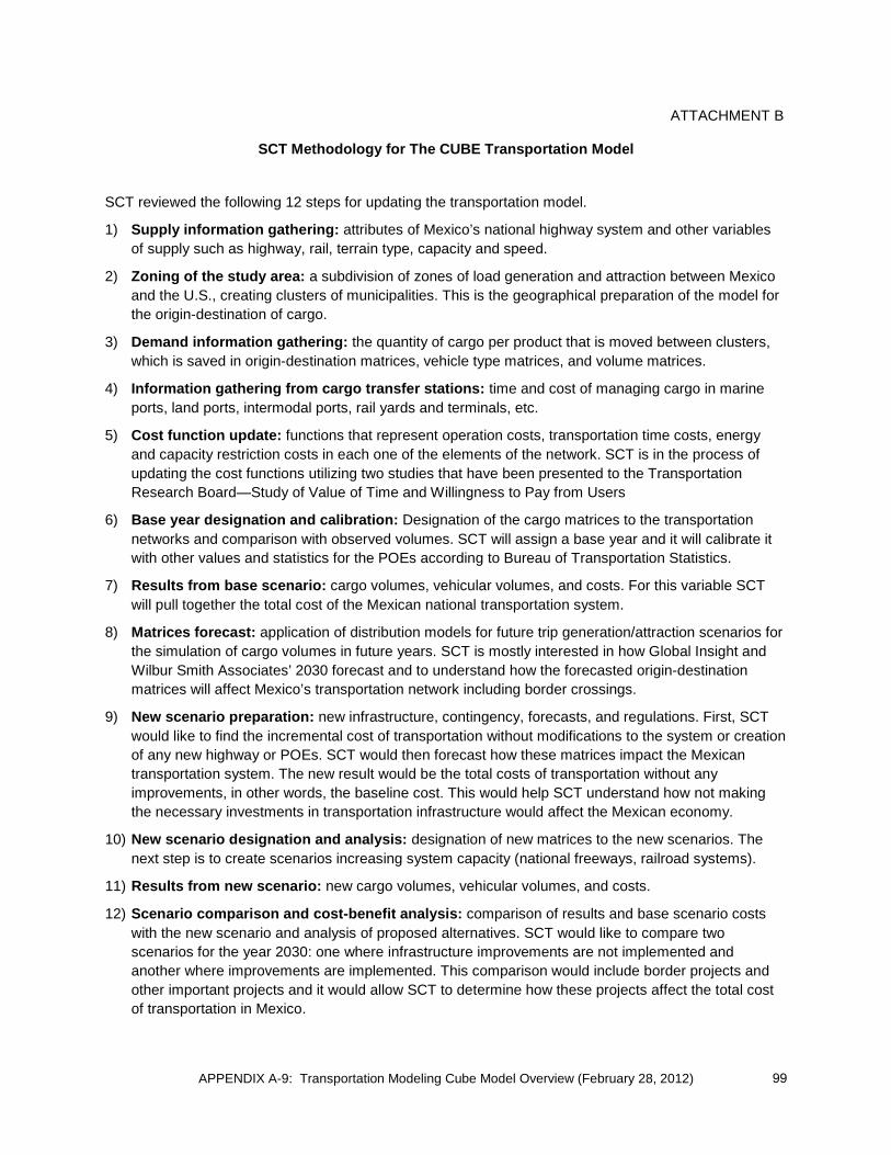
APPENDIX A-9: Transportation Modeling Cube Model Overview (February 28, 2012)
ATTACHMENT B
SCT Methodology for The CUBE Transportation Model
SCT reviewed the following 12 steps for updating the transportation model.
1) Supply information gathering: attributes of Mexico’s national highway system and other variables of supply such as highway, rail, terrain type, capacity and speed.
2) Zoning of the study area: a subdivision of zones of load generation and attraction between Mexico and the U.S., creating clusters of municipalities. This is the geographical preparation of the model for the origin-destination of cargo.
3) Demand information gathering: the quantity of cargo per product that is moved between clusters, which is saved in origin-destination matrices, vehicle type matrices, and volume matrices.
4) Information gathering from cargo transfer stations: time and cost of managing cargo in marine ports, land ports, intermodal ports, rail yards and terminals, etc.
5) Cost function update: functions that represent operation costs, transportation time costs, energy and capacity restriction costs in each one of the elements of the network. SCT is in the process of updating the cost functions utilizing two studies that have been presented to the Transportation Research Board—Study of Value of Time and Willingness to Pay from Users
6) Base year designation and calibration: Designation of the cargo matrices to the transportation networks and comparison with observed volumes. SCT will assign a base year and it will calibrate it with other values and statistics for the POEs according to Bureau of Transportation Statistics.
7) Results from base scenario: cargo volumes, vehicular volumes, and costs. For this variable SCT will pull together the total cost of the Mexican national transportation system.
8) Matrices forecast: application of distribution models for future trip generation/attraction scenarios for the simulation of cargo volumes in future years. SCT is mostly interested in how Global Insight and Wilbur Smith Associates’ 2030 forecast and to understand how the forecasted origin-destination matrices will affect Mexico’s transportation network including border crossings.
9) New scenario preparation: new infrastructure, contingency, forecasts, and regulations. First, SCT would like to find the incremental cost of transportation without modifications to the system or creation of any new highway or POEs. SCT would then forecast how these matrices impact the Mexican transportation system. The new result would be the total costs of transportation without any improvements, in other words, the baseline cost. This would help SCT understand how not making the necessary investments in transportation infrastructure would affect the Mexican economy.
10) New scenario designation and analysis: designation of new matrices to the new scenarios. The next step is to create scenarios increasing system capacity (national freeways, railroad systems).
11) Results from new scenario: new cargo volumes, vehicular volumes, and costs.
12) Scenario comparison and cost-benefit analysis: comparison of results and base scenario costs with the new scenario and analysis of proposed alternatives. SCT would like to compare two scenarios for the year 2030: one where infrastructure improvements are not implemented and another where improvements are implemented. This comparison would include border projects and other important projects and it would allow SCT to determine how these projects affect the total cost of transportation in Mexico.
99

This page intentionally left blank

California-Baja California Border Master Plan (BMP) Update Peer Exchange: BMP Modeling Efforts
Please note there will not be simultaneous English/Spanish translation Favor de notar no habrá traducción simultánea
June 27, 2012 (Wednesday) 10 a.m. to 12:30 p.m. SANDAG 401 B Street, San Diego, CA 92101 7th Floor Conference Room Phone Bridge Call-in numbers and pass code: From U.S.: 1 (888) 204-5987 From Mexico International Toll: 1 (602) 333-2017 Pass code (both countries): 9252950#
Meeting Objectives:
1. Discuss and obtain input on the analysis, data, and tools needed to move toward the development of a model that could help assess the impact and sensitivity of POE and transportation infrastructure investments with technical experts in the California-Baja California region.
2. Discuss definition of performance measures and assessment of the gap analysis, and determine if there are other models and/or sources of data that should be included in the assessment.
3. Discuss 2040 border crossing forecast assumptions and obtain input.
AGENDA Item 1 Welcome, introductions, and meeting objectives (Bill Figge, Caltrans/Carlos Lopez, SIDUE) Item 2 + Facilitated discussion on draft assessment of performance measures and gap analysis for
future transportation and POE modeling tool for BMP purposes (Clint Daniels, Service Bureau) Item 3 2040 border crossing projections: a discussion (Pat Landrum; Caltrans) Item 4: Summary of Peer Exchange input and next steps (Elisa Arias/Cheryl Mason, Service Bureau) + Items with attachments
APPENDIX A-10: Transportation Modeling Peer Exchange (June 27, 2012) 101

AGENDA ITEM 2 California-Baja California BMP Update BMP Modeling Peer Exchange June 27, 2012
1
Task 5: Port of Entry (POE) Sensitivity Analysis Modeling Framework and Gap Analysis
DRAFT for Peer Exchange Discussion
Task 5 of the California-Baja California Border Master Plan (BMP) Update includes identifying the level of analysis, data, tools, and funding needed to move toward the development of a model that could help assess the impact and sensitivity of port of entry (POE) and transportation infrastructure investments. This task focuses on developing a potential modeling framework for use in the future to conduct POE sensitivity analyses for capital improvements in a system of POEs in a metropolitan area. This task includes conducting a gap analysis; that is, to examine the gap between the capabilities of existing models and the future model envisioned in the modeling framework. In other words, the gap analysis intends to answer the question of how do we get from here to there.
The Service Bureau proposed selected key performance indicators that could be evaluated with a future model that would be able to conduct POE sensitivity analyses. These indicators were discussed with the Technical Working Group (TWG) and the Policy Advisory Committee (PAC). The PAC approved the performance measures and approach for completing this task at its May 17, 2012 meeting.
In order to produce a framework for a travel demand model with the ability to conduct POE sensitivity analyses and to produce a gap analysis, the Service Bureau proposes the following steps:
• Develop framework and identify key performance measures / or metrics needed in a future model to measure the “impacts” of infrastructure projects
• Assess whether the existing POE and transportation models are able to generate the necessary metrics
• Determine gaps between the capabilities of existing models and the future model envisioned in the modeling framework
• Develop cost estimate and time frame for a future travel demand model
Assessment of Key Performance Measures
If such a model were to be developed, what performance measures would be necessary for the effort? Clearly, as capacity and operational improvements are evaluated, it is important to develop a consistent set of performance metrics to choose to evaluate the outcomes of each investment. With this in mind, 20 performance measures for both the northbound and southbound directions were identified as necessary metrics for a future model that would be able to conduct POE sensitivity analyses. The following sections describe each of the 20 performance measures including definition, time period for data, historical data, and current forecasting methods. We will also be describing future needs, and the related level of effort required to obtain the data and develop the metric in a subsequent memo. The performance measures for a future model are grouped into the following categories.
APPENDIX A-10: Transportation Modeling Peer Exchange (June 27, 2012)102

AGENDA ITEM 2 California-Baja California BMP Update BMP Modeling Peer Exchange June 27, 2012
2
Key Performance Measures by Category
I. Crossings by POE Performance measures 1-7 1. Person Crossings by Private Operating Vehicle (POV) & Buses by POE 2. POV Crossings by POE 3. Pedestrian Crossings by POE 4. Bus Crossings by POE 5. Commercial Truck Crossings by POE 6. Commercial TEU Crossings by POE (TEU or other measurement) 7. Commodity Flow by POE
II. Wait Times by POE
Performance measures 8-11 8. Wait Time By Passenger Vehicle Regular & FAST/Empresa Certificada Lane by POE 9. Wait Time By Commercial Vehicle Regular & FAST/Empresa Certificada Lane by POE 10. Wait Time by Pedestrian Regular, SENTRI, and Ready Lane by POE 11. Queue Length by Travel Mode (Passenger, Commercial, Pedestrian)
III. Roadway and Transit Performance
Performance measures 12-15 12. Level of Service of Federal and State Highways in Study Area 13. Level of Service of Prime Arterials in immediate Vicinity of POEs 14. Boardings and Alightings by Transit Station near POEs 15. Transit Level of Service at Station and Routes Serving POEs
IV. Air Quality
Performance measures 16-17 16. Community Level Air Quality 17. Greenhouse Gas Emissions
V. Economic Indicators
Performance measures 18-20 18. Regional Gross Domestic Product 19. Job Creation from Project Investment 20. Average Wage of Jobs Created
APPENDIX A-10: Transportation Modeling Peer Exchange (June 27, 2012) 103

AGENDA ITEM 2 California-Baja California BMP Update BMP Modeling Peer Exchange June 27, 2012
3
I. Crossings by POE (Performance Measures 1-7)
1. Person Crossings by Privately Owned Vehicle (POVs) and Buses by POE
Definition
The total number of persons crossing the border during the given time period using a vehicle, excluding freight crossings. For example, a loaded passenger bus may have 60 person crossings for each vehicle crossing. A single occupant automobile would have one person crossing for each vehicle crossing.
Time Period
☒ Average Weekday
☒ Average Peak Period
☒ Average Peak Hour
☒ Average Peak Hour (Seasonal)
☒ Average Weekend
☐ Average Annual
Historic Data
The U.S. Bureau of Transportation Statistics (BTS) Border Crossing/Entry Data provides summary statistics for northbound crossings at the U.S.-Mexico border at the port level. Data are available for passenger crossings in POVs, passenger crossings on buses, and pedestrians entering the United States. Border crossing data are collected at border ports by U.S. Customs and Border Protection (CBP). CBP does not collect comparable data on outbound crossings.1 BTS provides a website where northbound person crossings can be obtained by month back to 1995.
The United States and Mexico do not publicly report southbound crossings at the U.S.-Mexico at the port level. Aduanas does not collect or maintain southbound person crossing information..
2. Passenger Vehicle Crossings by POE
Definition
The total number of non-commercial vehicles crossing the border during the given time period. Non-commercial vehicles may include passenger automobiles, light-duty trucks, and motorcycles, and motor homes. In essence this metric includes any vehicle that does not cross via a commercial POE or bus inspection.
Time Period
☒ Average Weekday
☒ Average Peak Period
☒ Average Peak Hour
☒ Average Peak Hour (Seasonal)
☒ Average Weekend
☐ Average Annual
1 Text extracted directly from Bureau of Transportation Statistics website. <http://www.bts.gov/programs/international/transborder/TBDR_BC/TBDR_BC_Index.html>
APPENDIX A-10: Transportation Modeling Peer Exchange (June 27, 2012)104
AGENDA ITEM 2 California-Baja California BMP Update BMP Modeling Peer Exchange June 27, 2012
4
Historic Data
BTS Border Crossing/Entry Data provides summary statistics for northbound crossings at the U.S.-Mexico border at the port level. Data are available for personal vehicles and passengers. Border crossing data are collected at border ports by CBP. The data reflect the number of vehicles and passengers entering the United States. CBP does not collect comparable data on outbound crossings.2 BTS provides a Web site where northbound personal vehicle crossings can be obtained by month back to 1995.
The United States and Mexico do not publicly report southbound crossings at the U.S.-Mexico border at the port level. However, Aduanas has provided southbound vehicle crossing information in the past for border and economic development studies.
3. Pedestrian Crossings by POE
Definition
The total number of people walking across the border during the given time period. This measurement also includes the total number of cyclist crossing the border as cyclists are required to dismount and walk through the border inspection facility.
Time Period
☒ Average Weekday
☒ Average Peak Period
☒ Average Peak Hour
☒ Average Peak Hour (Seasonal)
☒ Average Weekend
☐ Average Annual
Historic Data
BTS Border Crossing/Entry Data provides summary statistics for northbound crossings at the U.S.-Mexico border at the port level. Data are available for pedestrians. Border crossing data are collected at border ports by CBP. The data reflect the number of pedestrians entering the United States. CBP does not collect comparable data on outbound crossings.3 BTS provides a website where northbound crossings can be obtained by month back to 1995.
The United States and Mexico do not publicly report southbound crossings at the U.S.-Mexico border at the port level. Aduanas does not collect or maintain southbound pedestrian crossing information.
2 Text extracted directly from Bureau of Transportation Statistics website. <http://www.bts.gov/programs/international/transborder/TBDR_BC/TBDR_BC_Index.html> 3 Text extracted directly from Bureau of Transportation Statistics website. <http://www.bts.gov/programs/international/transborder/TBDR_BC/TBDR_BC_Index.html>
APPENDIX A-10: Transportation Modeling Peer Exchange (June 27, 2012) 105

AGENDA ITEM 2 California-Baja California BMP Update BMP Modeling Peer Exchange June 27, 2012
5
4. Bus Crossings by POE
Definition
The total number passenger busses or coaches crossing the border during the given time period. This measurement includes mainly medium and long-distance charter coaches.
Time Period
☒ Average Weekday
☒ Average Peak Period
☒ Average Peak Hour
☒ Average Peak Hour (Seasonal)
☒ Average Weekend
☐ Average Annual
Historic Data
BTS Border Crossing/Entry Data provides summary statistics for northbound crossings at the U.S.-Mexico border at the port level. Data are available for buses. Border crossing data are collected at border ports by CBP. The data reflect the number of vehicles and passengers entering the United States. CBP does not collect comparable data on outbound crossings.4 BTS provides a website where northbound bus crossings can be obtained by month back to 1995.
The United States and Mexico do not publicly report southbound crossings at the U.S.-Mexico border at the port level. However, Aduanas has provided southbound vehicle crossing information in the past for border and economic development studies.
5. Commercial Truck Crossings by POE
Definition
This measurement is the total number commercial vehicles crossing the border during the given time period. This measurement includes both loaded and empty commercial vehicles that move through the international commercial vehicle crossings (i.e., Otay Mesa-Mesa de Otay, Otay Mesa East-Mesa de Otay II, Tecate-Tecate, Calexico East-Mexicali II, and Andrade-Algodones). This measure does not include trains or rail containers.
Time Period
☒ Average Weekday
☒ Average Peak Period
☒ Average Peak Hour
☐ Average Peak Hour (Seasonal)
☒ Average Weekend
☐ Average Annual
4 Text extracted directly from Bureau of Transportation Statistics website. <http://www.bts.gov/programs/international/transborder/TBDR_BC/TBDR_BC_Index.html>
APPENDIX A-10: Transportation Modeling Peer Exchange (June 27, 2012)106
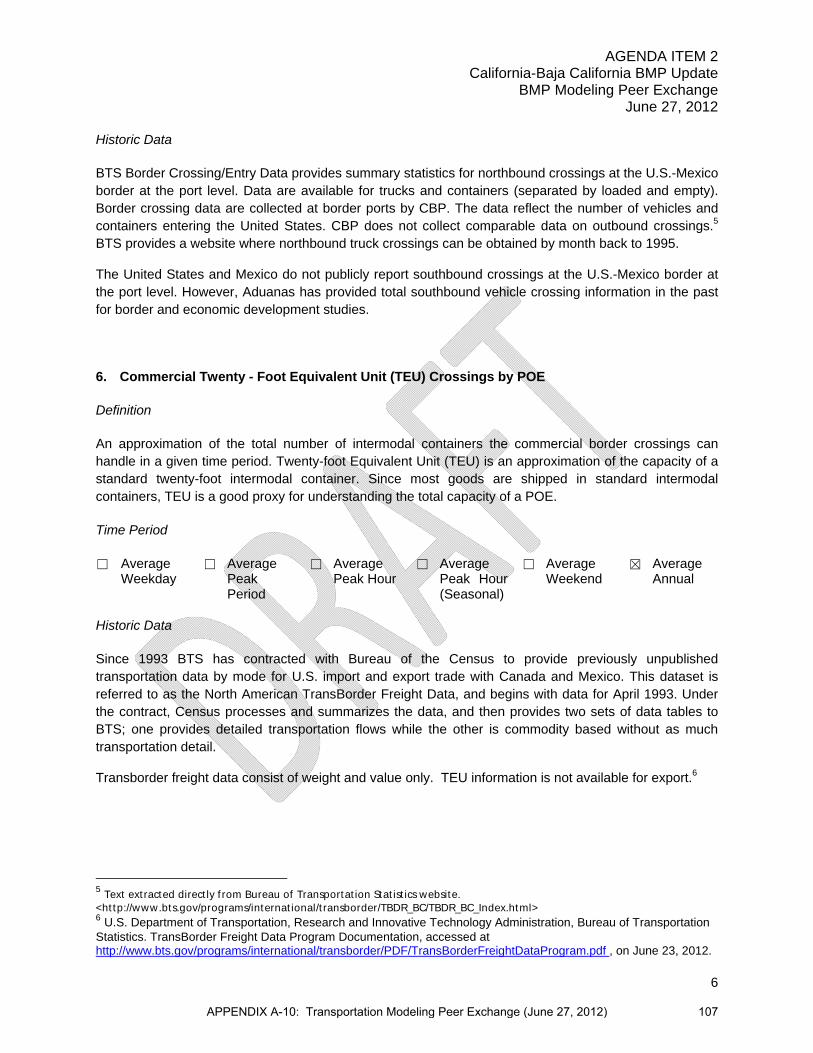
AGENDA ITEM 2 California-Baja California BMP Update BMP Modeling Peer Exchange June 27, 2012
6
Historic Data
BTS Border Crossing/Entry Data provides summary statistics for northbound crossings at the U.S.-Mexico border at the port level. Data are available for trucks and containers (separated by loaded and empty). Border crossing data are collected at border ports by CBP. The data reflect the number of vehicles and containers entering the United States. CBP does not collect comparable data on outbound crossings.5 BTS provides a website where northbound truck crossings can be obtained by month back to 1995.
The United States and Mexico do not publicly report southbound crossings at the U.S.-Mexico border at the port level. However, Aduanas has provided total southbound vehicle crossing information in the past for border and economic development studies.
6. Commercial Twenty - Foot Equivalent Unit (TEU) Crossings by POE
Definition
An approximation of the total number of intermodal containers the commercial border crossings can handle in a given time period. Twenty-foot Equivalent Unit (TEU) is an approximation of the capacity of a standard twenty-foot intermodal container. Since most goods are shipped in standard intermodal containers, TEU is a good proxy for understanding the total capacity of a POE.
Time Period
☐ Average Weekday
☐ Average Peak Period
☐ Average Peak Hour
☐ Average Peak Hour (Seasonal)
☐ Average Weekend
☒ Average Annual
Historic Data
Since 1993 BTS has contracted with Bureau of the Census to provide previously unpublished transportation data by mode for U.S. import and export trade with Canada and Mexico. This dataset is referred to as the North American TransBorder Freight Data, and begins with data for April 1993. Under the contract, Census processes and summarizes the data, and then provides two sets of data tables to BTS; one provides detailed transportation flows while the other is commodity based without as much transportation detail.
Transborder freight data consist of weight and value only. TEU information is not available for export.6
5 Text extracted directly from Bureau of Transportation Statistics website. <http://www.bts.gov/programs/international/transborder/TBDR_BC/TBDR_BC_Index.html> 6 U.S. Department of Transportation, Research and Innovative Technology Administration, Bureau of Transportation Statistics. TransBorder Freight Data Program Documentation, accessed at http://www.bts.gov/programs/international/transborder/PDF/TransBorderFreightDataProgram.pdf , on June 23, 2012.
APPENDIX A-10: Transportation Modeling Peer Exchange (June 27, 2012) 107
AGENDA ITEM 2 California-Baja California BMP Update BMP Modeling Peer Exchange June 27, 2012
7
7. Value of Commodity Crossings by POE
Definition
U.S. Transborder freight by dollar value that entered or exited the United States by surface modes of transport. Import and export value provide a good indication of how a specific POE compares to other POEs beyond the total number of vehicle crossings.
Time Period
☐ Average Weekday
☐ Average Peak Period
☐ Average Peak Hour
☐ Average Peak Hour (Seasonal)
☐ Average Weekend
☒ Average Annual
Historic Data
Since 1993 the BTS has contracted with Bureau of the Census to provide previously unpublished transportation data by mode for U.S. import and export trade with Canada and Mexico. This dataset is referred to as the North American TransBorder Freight Data, and begins with data for April 1993. Under the contract, Census processes and summarizes the data, and then provides two sets of data tables to BTS; one provides detailed transportation flows while the other is commodity based without as much transportation detail. The data consist of import and export value of various commodities identified by the specific POE and mode of transportation. The BTS statistics are available by month or annual average.
A number of changes to improve the quality and usefulness of the data have been implemented since the database was first made available. Beginning with the 1997 data, the North American TransBorder Freight Data represents official U.S. trade with Canada and Mexico for shipments that entered or exited the United States by surface modes of transport (other than air or maritime vessel). In 2007, BTS began providing commodity by POE at the Country level, however, commodity data are not provide by state of origin/destination and by POE due to confidentiality restrictions. 7
II. Wait Times by POE (Performance Measures 8-11)
8. Wait Time by Passenger Vehicles by POE (Regular, SENTRI, and Ready Lanes)
Definition
Wait times by passenger vehicles is defined as the wait time from the end of the queue to primary inspection. In the northbound direction, this measurement will indicate the wait time by passenger vehicles by POE by regular, Secure Trade Program and Secure Electronic Network for Travelers Rapid Inspection (SENTRI), and Ready lanes.In the southbound direction, this measurement will indicate the wait time by southbound passenger vehicles by POE by regular lanes. (The SENTRI and Ready lane programs do not exist in Mexico.) 7 U.S. Department of Transportation, Research and Innovative Technology Administration, Bureau of Transportation Statistics. TransBorder Freight Data Program Documentation, accessed at http://www.bts.gov/programs/international/transborder/PDF/TransBorderFreightDataProgram.pdf , on June 23, 2012.
APPENDIX A-10: Transportation Modeling Peer Exchange (June 27, 2012)108

AGENDA ITEM 2 California-Baja California BMP Update BMP Modeling Peer Exchange June 27, 2012
8
Time Period
☐ Average Weekday
☒ Average Peak Period
☒ Average Peak Hour
☐ Average Peak Hour (Seasonal)
☒ Average Weekend
☐ Average Annual
Historic Data
Northbound passenger vehicle border crossing wait times at POEs along the U.S.-Mexico border are gathered and relayed by CBP. CBP posts current border wait times at all POEs and all modes of transportation on its public website. Border wait times information includes wait times by hour, number of inspection lanes open, and capacity in terms of maximum number of inspection lanes. The information also includes border wait times segregated by different CBP administered programs, such as SENTRI and Ready Lanes.
Historical wait times information (July 2010 to current) is available from SANDAG for northbound crossing times at POEs in the California-Baja California region. On a regular basis, SANDAG scans the CBP reported wait time information from the CBP Web site and stores it in a database for future needs.
Southbound passenger vehicle border crossing wait times at POEs along the U.S.-Mexico border are not compiled. However, crude wait times could be derived for Otay Mesa-Mesa de Otay and San Ysidro-Puerta México POEs from the Caltrans Highway Performance Measurement System (PeMS). The PeMS system provides information on traffic speed and congestion on Caltrans facilities on a minute by minute basis. Historical information is available back to 2001. The chart below from PeMS shows the average speed declining dramatically on I-5 approaching San Ysidro-Puerta México POE on a Friday evening.
APPENDIX A-10: Transportation Modeling Peer Exchange (June 27, 2012) 109

AGENDA ITEM 2 California-Baja California BMP Update BMP Modeling Peer Exchange June 27, 2012
9
These data could provide a rough approximation for southbound border queue lengths and wait times.
9. Wait Time by Commercial Vehicle by POE (Regular and FAST Lanes)
Definition
Commercial vehicle wait time is defined as the time from the end of the queue to primary inspection. For northbound, this measurement will indicate the wait time by commercial vehicles by POE by regular and by FAST (Fast and Secure Trade Program) lanes. In the southbound direction, the measurement will indicate the wait time by southbound commercial vehicles by POE by regular and by Empresa Certificada (similar to FAST) lanes.
Time Period
☐ Average Weekday
☒ Average Peak Period
☒ Average Peak Hour
☐ Average Peak Hour (Seasonal)
☒ Average Weekend
☐ Average Annual
Historic Data
Northbound commercial vehicle border crossing wait times at POEs along the U.S.-Mexico border are gathered and relayed by CBP. CBP posts current border wait times at all commercial POEs and on its
APPENDIX A-10: Transportation Modeling Peer Exchange (June 27, 2012)110

AGENDA ITEM 2 California-Baja California BMP Update BMP Modeling Peer Exchange June 27, 2012
10
public website. Border wait times information includes wait times by hour and capacity in terms of maximum number of inspection lanes. The information also includes border wait times segregated by different CBP administered programs, such as the Free and Secure Trade (FAST) program.
Historical wait times information (July 2010 to current) is available from SANDAG for northbound crossing times at POEs in the California-Baja California region. On a regular basis, SANDAG scans the CBP reported wait time information from the CBP Web site and stores it in a database for future needs.
Southbound commercial vehicle border crossing wait times at POEs along the U.S.-Mexico border are not collected.
10. Wait Time for Pedestrians by POE (Regular, SENTRI, and Ready Lanes)
Definition
Pedestrian wait time is defined as the time from the end of the queue to primary inspection. In the northbound direction, this measurement will indicate the wait time for pedestrians by regular, SENTRI, and Ready lanes.
In the southbound direction, this measurement will indicate the wait time for southbound pedestrians by POE by regular lanes. (The SENTRI and Ready lane programs do not exist in Mexico.)
Time Period
☐ Average Weekday
☒ Average Peak Period
☒ Average Peak Hour
☐ Average Peak Hour (Seasonal)
☒ Average Weekend
☐ Average Annual
Historic Data
Northbound pedestrian border crossing wait times at POEs along the U.S.-Mexico border are gathered and relayed by CBP. CBP posts current border wait times for pedestrians at all POEs on its public website. Border wait times information includes wait times by hour and capacity in terms of maximum number of inspection lanes. The information also includes border wait times segregated by different CBP administered programs, such as SENTRI and Ready Lanes.
Historical wait times information (July 2010 to current) is available from SANDAG for northbound crossing times at POEs in the California-Baja California region. On a regular basis, SANDAG scans the CBP reported wait time information from the CBP Web site and stores it in a database for future needs.
Southbound pedestrian wait times at POEs along the U.S.-Mexico border are not collected.
APPENDIX A-10: Transportation Modeling Peer Exchange (June 27, 2012) 111
AGENDA ITEM 2 California-Baja California BMP Update BMP Modeling Peer Exchange June 27, 2012
11
11. Queue Length by Mode (Passenger Vehicle, Commercial, and Pedestrian lanes)
Definition
This measurement will calculate the length of queues at the POE during the peak period and peak hour for the select transportation mode.
Time Period
☐ Average Weekday
☒ Average Peak Period
☒ Average Peak Hour
☐ Average Peak Hour (Seasonal)
☐ Average Weekend
☐ Average Annual
Historic Data
No official information is collected on queue length in either the northbound or southbound direction. Crude historical estimations could be made using historical northbound border wait times and PeMS data for southbound queues.
III. Roadway and Transit Performance (Performance Measures 12-15)
12. Level of Service on Federal and State Highways in Study Area
Definition
This measurement will use the Transportation Research Board’s Highway Capacity Manual’s definition of highway level of service to measure the impacts of POE investments.
Time Period
☐ Average Weekday
☒ Average Peak Period
☒ Average Peak Hour
☐ Average Peak Hour (Seasonal)
☐ Average Weekend
☐ Average Annual
Historic Data
Historic information in the United States is available back to 2001 through the Caltrans Performance Measurement System (PeMS).
13. Level of Service on Prime Arterials in Immediate Vicinity of POE
Definition
This measurement will use the Transportation Research Board’s Highway Capacity Manual’s definition of arterial level of service to measure the impacts of POE investments.
APPENDIX A-10: Transportation Modeling Peer Exchange (June 27, 2012)112

AGENDA ITEM 2 California-Baja California BMP Update BMP Modeling Peer Exchange June 27, 2012
12
Time Period
☐ Average Weekday
☒ Average Peak Period
☒ Average Peak Hour
☐ Average Peak Hour (Seasonal)
☐ Average Weekend
☐ Average Annual
Historic Data
Historic information in the United States is available on a limited basis from the local jurisdictions or regional planning agency whose jurisdiction covers the facility.
14. Transit Boardings and Alightings near POE
Definition
This is a measurement of the total number of transit boardings and alightings near transit stations. In the United States, this measurement will be limited to boardings and alightings on the San Diego Metropolitan System (MTS) trolley and buses. In Mexico, this measurement will include officially licensed buses..
Time Period
☒ Average Weekday
☒ Average Peak Period
☒ Average Peak Hour
☐ Average Peak Hour (Seasonal)
☒ Average Weekend
☐ Average Annual
Historic Data
In the United States, MTS and Imperial Valley Transit (IVT) provide historical transit boardings and alightings for the trolley and local busses serving the border region.
In Mexico, the Metropolitan Planning Institute of Tijuana (IMPLAN) and the Municipal Institute of Research and Planning of Mexicali (IMIP) provide historical transit boardings and alightings for all officially sanctioned buses and private jitneys near the border region.
15. Transit Level of Service near POE
Definition
This measure will use methodologies outlined in the Transportation Research Board’s (TRB) Transit Cooperative Research Program (TCRP) Report 100: Transit Capacity and Quality of Service Manual, 2nd Edition. This report outlines deriving a comprehensive transit level of service based on transit accessibility, frequency, and load.
APPENDIX A-10: Transportation Modeling Peer Exchange (June 27, 2012) 113

AGENDA ITEM 2 California-Baja California BMP Update BMP Modeling Peer Exchange June 27, 2012
13
Time Period
☒ Average Weekday
☒ Average Peak Period
☒ Average Peak Hour
☐ Average Peak Hour (Seasonal)
☒ Average Weekend
☐ Average Annual
Historic Data
While no agency provides a comprehensive, single transit level of service indicator, most transit operators provide some components of level of service like frequency and load factors.
IV. Air Quality (Performance Measures 16-17)
16. Community Air Quality
Definition
This is a measurement of the average daily amount of smog forming pollutant and particular matter produced by the on-road transportation sector before and after the POE investment. This measurement will gauge the ambient air quality near a proposed project.
Time Period
☒ Average Weekday
☐ Average Peak Period
☐ Average Peak Hour
☐ Average Peak Hour (Seasonal)
☐ Average Weekend
☐ Average Annual
Historic Data
17. Greenhouse Gas Emissions
Definition
This is a measurement of the annual amount of carbon dioxide equivalent emissions produced by the on-road transportation sector before and after the POE investment. This measurement includes greenhouse gas emissions for both the SB 375 vehicle types as well as medium-heavy duty and heavy-heavy duty trucks.
Time Period
☐ Average Weekday
☐ Average Peak Period
☐ Average Peak Hour
☐ Average Peak Hour (Seasonal)
☐ Average Weekend
☒ Average Annual
APPENDIX A-10: Transportation Modeling Peer Exchange (June 27, 2012)114
AGENDA ITEM 2 California-Baja California BMP Update BMP Modeling Peer Exchange June 27, 2012
14
Historic Data
Researchers at San Diego State University have performed localized air quality assessments near in Tijuana near the San Ysidro POE. Researchers identified higher localized air pollution near the POE than in the city of Tijuana as a whole.8
California Air Resources Board (CARB) has conducted studies that may be useful.
V. Economic Indicators (Performance Measures 18-20)
18. Regional Gross Domestic Product (GDP)
Definition
This is the value of all goods and services produced within the border region.
Time Period
☐ Average Weekday
☐ Average Peak Period
☐ Average Peak Hour
☐ Average Peak Hour (Seasonal)
☐ Average Weekend
☒ Average Annual
Historic Data
Historic GDP information for San Diego County is available from the U.S. Bureau of Economic Analysis. Data for Imperial County are not produced by any government source.
In Mexico, data are available at the statewide level from Instituto Nacional de Estadística y Geografía (INEGI).
19. Job Creation from Project Investment
Definition
The number of jobs created due to the investment of border infrastructure. These would include the direct jobs induced by the investment (e.g., border agents, truck drivers, manufacturing jobs) and the indirect jobs (e.g., restaurant and service) resulting shopping and spending from those directly employed due to the investment.
8 Greening Transportation at the Border. U.S./Mexico Joint Working Committee on Transportation Planning.
APPENDIX A-10: Transportation Modeling Peer Exchange (June 27, 2012) 115

AGENDA ITEM 2 California-Baja California BMP Update BMP Modeling Peer Exchange June 27, 2012
15
Time Period
☐ Average Weekday
☐ Average Peak Period
☐ Average Peak Hour
☐ Average Peak Hour (Seasonal)
☐ Average Weekend
☒ Average Annual
Historic Data
20. Average Wage of Jobs Created
Definition
The average annual salary of the jobs created due to the investment of border infrastructure. These would include the direct jobs induced by the investment (e.g., border agents, truck drivers, manufacturing jobs) and the indirect jobs (e.g., restaurant and service) resulting shopping and spending from those directly employed due to the investment.
Time Period
☐ Average Weekday
☐ Average Peak Period
☐ Average Peak Hour
☐ Average Peak Hour (Seasonal)
☐ Average Weekend
☒ Average Annual
Historic Data
While economic impacts of border waits have been estimated in the past by SANDAG, no government organization has attempted to quantify the average wage of a job created by investing infrastructure.
APPENDIX A-10: Transportation Modeling Peer Exchange (June 27, 2012)116

CA
LIF
OR
NIA
.BA
JA
CA
LIF
OR
NIA
201
1112
BO
RD
ER
MA
ST
ER
PLA
N U
PD
AT
EF
OC
US
GR
OU
P:
BM
P M
OD
ELI
NG
E
FF
OR
TS
--P
EE
R E
XC
HA
NG
E..J
UN
E 2
7,20
.I2
APPENDIX A-10: Transportation Modeling Peer Exchange (June 27, 2012) 117

CA
LIF
OR
NIA
.BA
JA
CA
TIF
OR
NIA
201
11'1
2 E
OR
DE
R M
AS
TE
R
PLA
N U
PD
AT
E
FO
CU
S G
RO
UP
: B
MP
MO
DE
LIN
G E
FF
OR
TS
--P
EE
R E
XC
HA
NG
E..J
UN
E 2
7,20
12
Sity
of
San
Die
ooS
amlr
laiii
riT
WG
)ity
of S
an D
iego
1222
Firs
tAv,
MS
413
San
Die
go92
101
'619
) 53
3-65
51rh
aiiir
i@sa
ndie
qo.
oov
@C
ity o
f C
hula
Vis
taD
ave
l(apl
anT
WG
:ity
of C
hula
Vis
ta27
6 F
ourt
h A
ve.
lhul
a V
ista
t191
0:6
19)
691-
5025
Jkao
lan@
ci.c
hula
-vis
ta.c
a.
usLE
KC
ity o
f C
alex
ico
Nic
kS
ervi
n\L
Tiit
v of
Cal
exic
oLt
9r/€
E ?
.tlss
&et
?22t
t73
4*/
-7r'a
tls
ervi
nl@
@!e
xi@
!ajg
\L4
APPENDIX A-10: Transportation Modeling Peer Exchange (June 27, 2012)118

CA
LIF
OR
NIA
-BA
JA
CA
TIF
OR
NIA
201
1112
BO
RD
ER
MA
ST
ER
PIA
N U
PD
AT
EF
OC
US
GR
OU
P:
8MP
MO
DE
LIN
G
EF
FO
RT
S--
PE
ER
EX
CH
AN
GE
-.IU
NE
27
, 20
12
drrz
o.€r
2oct
- Q
bgo'
APPENDIX A-10: Transportation Modeling Peer Exchange (June 27, 2012) 119

APPENDIX A-10: Transportation Modeling Peer Exchange (June 27, 2012)120

California-Baja California 2014 Border Master Plan (BMP) Update
Peer Exchange:
U.S. – Mexico Border Master Planning for Port of Entry and Connecting Transportation Infrastructure: Why and How to Fund this Borderwide Process
October 24, 2013
(Final Summary, February 27, 2014)
Overview:
On behalf of the California Department of Transportation (Caltrans) and the Secretariat of Infrastructure and Urban Development of the State of Baja California (SIDUE), the San Diego Association of Government (SANDAG) Service Bureau conducted a peer exchange in October 2013, entitled, “U.S. – Mexico Border Master Planning for Port of Entry and Connecting Transportation Infrastructure: Why and How to Fund this Borderwide Process.”
As the title implies, the focus of the Peer Exchange was broader than the California-Baja California region and it encompassed the border master planning for international land ports of entry (POE) and connecting transportation infrastructure for the entire U.S.-Mexico border region. The Peer Exchange brought together staff from federal agencies as well as from state, regional, and local agencies involved in the border master planning processes at the ten U.S.-Mexico border states and both federal governments. Federal attendees provided their perspective on border master planning and funding strategies and state representatives who have completed or are conducting BMP studies provided a statewide perspective. The goal of seeking this broader participation was to learn from the perspectives and experiences on border master planning beyond the California-Baja California region and also share the California-Baja California BMP practices with the other border regions, and to start a border-wide/binational process leading to identifying and securing long term, sustainable funding for BMPs.
This peer exchange identified issues and ideas that could be used in the development of a U.S.-Mexico borderwide strategy to ensure continuity and secure long-term funding for the border master planning process. This paper documents its summary, and it will be shared with the U.S.-Mexico Joint Working Committee (JWC) for its consideration to develop and advance a potential binational BMP funding strategy.
Participating Agencies:
Participating federal agencies:
United States: Department of State (DOS); General Services Administration (GSA); Customs and Border Protection (CBP); Federal Highway Administration (FHWA); Environmental Protection Agency (EPA)
Mexico: Secretariat of Foreign Relations (SRE); Secretariat of Communications and Transportation (SCT); Institute of Administration and Estimates of National Real Estate (INDAABIN); and the National Immigration Institute (INM)
Binational: North American Development Bank (NADBANK)
APPENDIX A-11: BMP Funding Peer Exchange (October 24, 2013) 121

Participating state, regional, and local agencies:
United States: Arizona Department of Transportation (ADOT), Caltrans, New Mexico Department of Transportation (NMDOT) (submitted written comments), Texas Department of Transportation (TDOT), San Diego Association of Governments (SANDAG), Imperial County Transportation Commission (ICTC), County of San Diego, City of San Diego, City of National City, City of Calexico,
Mexico: SIDUE, State of Tamaulipas (reported on efforts in Chihuahua, Coahuila, Nuevo Leon and Tamaulipas), and Metropolitan Planning Institute of Tijuana (IMPlan).
Appendix 1 lists the participants who attended the October 24, 2013 peer exchange or participated via teleconference call.
Background and Objectives of the Meeting (Agenda Item 2)
As stated above, the objective of the Peer Exchange was to discuss and obtain input on developing a U.S.-Mexico borderwide strategy to ensure continuity and secure long-term funding for the border master planning process. Up to this point, each U.S-Mexico state pair or border region has sought funding for its own BMP’s on a “case-by-case” basis. Most of the funding has come from the FHWA via the U.S.-Mexico JWC. Some States have contributed with own State Planning and Research (SPR), in kind staff time, and, other federal funds, including own state match from federal allocations. State representatives have expressed interest in securing on-going or more regular sustainable funding to ensure continuity and certainty in the binational border master planning process. Federal agencies also have been receptive to exploring future borderwide funding opportunities. This Peer Exchange intended to capture these ideas and “Kick-Off” a formal dialogue toward a future U.S.-Mexico borderwide strategy to ensure continuity and fund the border master planning process.
Two schools of thought on funding were highlighted:
1. “Build it and they will come.” The rationale under this approach is that developing useful planning documents would lead to the allocation (or re-allocation) of future funding to conduct periodic updates from available sources on an “ad- hoc” basis;
2. Designated BMP funding from traditional planning processes. The BMP effort is the only binational planning process for POE and transportation infrastructure that includes a methodology that is accepted on both sides of the border and results in a level playing field for evaluation and prioritization of projects. However, this binational process does not have a long-term sustainable funding source that would allow for continuity and certainty of BMP updates. A stable funding source would be needed to convert the next generation of BMPs into a continuing planning process, thus allowing on-going certainties that give added value to investments in technical capabilities and improvements to this newly created series of regional studies. .
The discussion focused on the vision for border master planning for POE and connecting transportation infrastructure. Questions considered included: Are the states’ visions the same as the federal vision? Is the BMP planning process needed? If so, what is the strategy for long-term planning and funding processes?
APPENDIX A-11: BMP Funding Peer Exchange (October 24, 2013)122
Federal Perspective on Border Master Planning Process (Agenda Item 3)
The following representatives provided remarks on the federal perspective:
• Luis Javier Castro Castro (SRE) and Steven Kameny (DOS) focused on the Binational Bridges and Border Crossings Group (BBBXG) relative to the U.S.-Mexico High Level Economic Dialogue (HLED); and
• Sylvia Grijalva (FHWA) and Marco Antonio Frias Galvan (SCT) focused on the U.S.-Mexico Joint Working Committee (JWC).
U.S.-Mexico High Level Economic Dialogue (HLED)
• Luis Javier Castro Castro provided an overview of the High Level Economic Dialogue (HLED or Diálogo Económico de Alto Nivel (DEAN, in Spanish) as it pertained to BMPs. Highlights are:
o To elevate and strengthen the dynamic bilateral commercial and economic relationship, between U.S. and Mexico, President Obama and President Peña Nieto have agreed to establish a High Level Economic Dialogue (HLED). A meeting between U.S. Vice President Biden and representatives from SRE, SCT, and the Ministry of Finance and Public Credit (Secretaría de Hacienda y Crédito Público (SHCP) took place on September 20, 2013 to launch the HLED. The HLED, which will be led at the Cabinet level, is envisioned as a flexible platform intended to advance strategic economic and commercial priorities central to promoting mutual economic growth, job creation, and global competitiveness. The HLED will explore ways to promote competitiveness through enhanced cooperation in specific sectors that connect our economies, including the areas of transportation, telecommunications, and energy, as well as promoting greater two-way investment.
o SCT, SRE, and other agencies are working together to implement actions to accomplish the goals of HLED.
o HLED includes areas that specifically relate to BMPs. Trends show that the flow of cargo at border crossings will grow faster in the short term. Therefore, the BMPs need to:
Address a strategy for the identification and integration of national corridors to networks within the cities that allow fast and efficient flows within the urban areas surrounding border crossings.
Improve the mechanisms and instruments that are already included in the BMPs, but which must be perfected and updated. In the long run, this would promote local economic development and binational competitiveness.
Strengthen efforts to identify key logistics corridors and coordinate national planning of goods movement with the regional BMPs in order to provide a context for investment decisions at the national level to support binational trade flows.
o SRE noted that the BMPs should find a process that is compatible with the new proposed HLED that the U.S. and Mexico are implementing. SRE proposed establishing a common methodology and process be adopted for all the BMPs.
o NADBANK uses a 300 kilometer (km) bandwidth south of the border and can contribute funding to projects that meet the program’s requirements within the 300 km bandwidth.
APPENDIX A-11: BMP Funding Peer Exchange (October 24, 2013) 123

SRE proposed that BMPs consider a study area of 300 km on the Mexican side for consistency with NADBANK’s established boundary and for projects to be eligible for NADBANK funding and loans.
BBBXG and Other Federal Mechanisms:
• Steve Kameny (DOS) presented an overview of the Binational Bridges and Border Crossings Group (BBBXG), other federal mechanisms, and the role of the State Department. Highlights are as follows:
o BBBXG is a technical group that convenes federal and state agencies to discuss aspects of current and proposed infrastructure projects related to international POEs. The BMP process informs in this effort. The BMPs provide a broad regional outlook that incorporates the views of many regional stakeholders and give policy makers additional tools for decision making.
o The 21st Century Border Management Executive Steering Committee is a federal binational committee chaired on the U.S. side by the National Security Staff and on the Mexican side by the Secretariat of Foreign Relations. The Executive Steering Committee works in a collaborative and coordinated fashion across a wide-range of border-related activities, and has a high-level perspective for binational border management. The BMP provides local outlook and perspective to the Executive Steering Committee.
o The DOS role is generally to coordinate and convene, but its major technical function is to coordinate Federal action related to the issuance and amendment of Presidential permits, as outlined in Executive Order 11423. Project sponsors proposing new POEs or significant changes to existing ones need a Presidential permit. The processing of Presidential permit applications can be a multi-year procedure. The review process is to determine if the proposed new POE or modification is in the national interest. This decision is informed by many stakeholders and DOS consults with a number of federal agencies to make a determination as to whether the issuance of a permit is in the national interest. The BMP contributes to this process by providing state and local input and insight.
U.S.-Mexico Joint Working Committee (JWC)
• Sylvia Grijalva (FHWA) and Marco Antonio Frias Galvan (SCT) presented an overview of the U.S. Mexico JWC. Highlights are as follows:
o The JWC was created after the passage of NAFTA in 1994. Its main function is to promote effective communication and coordination on border transportation networks. The JWC focuses on activities that help the planning of POEs and related transportation projects.
o The initial purpose of the BMPs was for stakeholders at the federal, state and local levels, to establish and agree on the priorities using criteria important to them. The BMP process is a systematic approach for prioritizing BMP facilities and planning processes. It helps improve coordination among federal and state and local processes. Robust data from both sides of the border are needed for this type of planning and ideally the data will continue to improve as efforts progress with the BMPs.
APPENDIX A-11: BMP Funding Peer Exchange (October 24, 2013)124

o Federal, state, and local agencies need to partner to develop funding strategies so that they can accommodate the needs for POEs.
o BMPs are a valuable tool to identify issues and needs at the national and local level suggested that the BMP process consider standardizing the methodology among all state BMPs. SCT sees the benefit of a common methodology across all plans and it would allow Mexico to make decisions at a national level.
State Perspective Border Master Planning Process (Agenda Item 4):
The following representatives provided remarks on the state perspective:
• Rudy Perez (ADOT) on the Arizona-Sonora BMP;
• Sergio Pallares (Caltrans) and Carlos Lopez (SIDUE) on the California-Baja California BMP;
• Eduardo Hagert (TDOT) and Miguel San Martin (State of Tamaulipas) on the Texas- Chihuahua-Coahuila-Nuevo Leon-Tamaulipas BMPs (three BMP efforts); and
• Homer Bernal (NMDOT) provided written responses to the questions, which were circulated to participants after the meeting.
The State representatives were asked to comment on the following themes.
1. How did you fund your current BMP effort (completed or ongoing)? What was the budget for your most recent plan? If under development, when is your current plan scheduled for completion?
2. How often do you plan to update your BMP? How do you plan to fund the next update and what is the estimated cost? Does your plan include a mechanism for monitoring the progress and implementation of projects in between updates?
3. What does your plan recommend regarding institutionalizing the border master planning process? In your opinion, why is it important to institutionalize it? What issues do you think it would resolve?
4. Do you feel a permanent funding source is needed to support the border master planning process? What benefits or advantages could result from permanent funding?
5. How was your BMP been incorporated into federal, state, or regional planning efforts or initiatives?
Responses from each state pair are documented in Appendix 2.
Facilitated Discussion: Where do we go from here? (Agenda Item 5a)
Current BMPs are mostly focusing on needs and priorities for new POEs or expansion of existing POEs and the connecting transportation facilities. This topic explore the vision for future BMPs. Will BMPs evolve into plans that focus on operational efficiencies and state of good repair? How can agencies make better use of current infrastructure and maintain the investments already made? Are current modeling tools capable of informing this type of planning? How do you gauge the success of the BMP?
APPENDIX A-11: BMP Funding Peer Exchange (October 24, 2013) 125

Many ideas were discussed by panelists. The ideas are grouped by major theme below and based on the input from the presentations and discussion of the panelists.
Vision of future BMPs
1. BMP should continue to be a systematic binational approach for regional border planning and resource maximization and providing a level playing field for project prioritization. BMPs are currently the only binational regional prioritization process for POE and connecting infrastructure projects. They allow for planning to transcend changes in federal and state administrations in the U.S. and in Mexico.
2. Future BMPs should continue to look at the improvements to POEs and the transportation access to them. But they should also expand the vision to look at pedestrian access to the POE and amenities that without detriment of national security issues, could improve the cross border experience for people waiting in long lines at international border crossings, including bike and pedestrian-friendly paths for crossing the border and sun and rain coverings plus other amenities like bathrooms, benches and designated access for the handicapped. .
3. Future BMPs may evolve from a focus on strategic planning for new POE and infrastructure projects into a focus on monitoring operational efficiencies of the projects.
4. Future BMPs should consider including an operational analysis to assess if regions are maximizing infrastructure that is already in place and optimizing the use of the existing POE facilities and infrastructure. This is especially important in light of limited funds for border infrastructure and will help reassure ourselves that we’re getting as much out of the facilities as we can without opening a new POE. For example, in San Ysidro-Puerta México, efforts include double stacking booths. But at end of day, if there is not sufficient funding to have the POE fully staffed, then we won’t get improved results. Another area could be to develop mechanisms related to advance traffic segmentation to facilitate vehicle inspection work entering the POEs. So some operational analysis needs to be done to match staff needs, new or improved infrastructure and traffic management principles—maybe there are efficiencies to be had with the existing infrastructure and investments that taxpayers have already made.
Data-driven BMP planning documents
5. BMPs need to be validated, data-driven documents in order to make them more valuable and important tools. A data-driven effort is objective and helps create a baseline which will help measure success as BMPs move forward.
6. Improving the availability of data on the Mexico side of the border is needed to match that of the U.S, in order to apply concurrent methodologies and analyses.
7. BMPs need to develop and incorporate more sophisticated and robust (transportation and POE throughput capacity) modeling data and practices into the BMP to conduct POE and connecting transportation network sensitivity analysis. The ability of the BMP to help develop better models will help prevent agencies from building bigger facilities than needed to, or, to fund transportation projects that may be not correctly sized or that may be in a different priority order. A tool that provides objective, validated data could be useful in Public Private Partnership (3Ps) applications. This kind of modeling is very expensive and that a lack of data in Mexico may prevent agencies from doing this kind of modeling. However, it is important to start thinking about next steps to keep the momentum moving toward this goal.
APPENDIX A-11: BMP Funding Peer Exchange (October 24, 2013)126

o Note: The California-Baja California BMP Update looked at developing a high level framework for what is needed to develop appropriate modeling tools. It focuses on a “handshake” between models in California and Baja California and strives to attain agreement on volume of cross border travel across POE facilities. The high level framework recommends looking at San Diego-Tijuana/Tecate as one border metropolitan area and Imperial-Mexicali as another border metropolitan area.
o Note: It appears that the culture of transportation modeling is different in the US and in Mexico. For instance, local planning agencies in Mexico have used transportation models in the past primarily in support of specific projects or studies, but there are no known on-going processes to support ongoing modeling process. In the U.S., regional and state agencies have developed travel demand models that are maintained, enhanced, and used regularly in the planning process. Agencies in both countries would have to coordinate on these efforts to align data, systems, approaches, land use. The Modeling tools for sensitivity analysis will need to be ongoing systematic processes which could help us all on address needs on a project-by-project basis.
8. Incorporate credible border wait time data into BMPs to help with prioritization of projects and identify POEs with operational deficiencies and/or infrastructure needs. Future BMP could use data from new tools that scientifically and objectively measure border wait times. A scientific way of measuring north bound cross border wait times for commercial vehicles has been developed in Texas. Some goals could be to report these data on the CBP Web site in the future as well as southbound cross border wait times into Mexico on appropriate Web Site(s).
9. BMP should consider incorporating relevant data from other studies such as those conducted by EPA/Secretariat of Environment and Natural Resources (SEMARNAT); GSA/INDAABIN; and CBP/Aduanas in order to build on work already completed. This could include studies on economic impact of border waits or studies measuring the impacts on air quality at the border and the relationship between cross-border wait times and emissions. As more environmental data are developed, especially emissions from idling trucks and cars to cross the border, the information could play a larger role in the BMP decision-making process.
o Note: FHWA U.S.–Mexico JWC has developed a template that relates emissions from idling vehicles to wait times. It has been tested at the El Paso POE, but specific POE wait time data and other variables need to be added to make emission estimates for other ports. Once the template is established for a port, it can also be used to test various operation scenarios to estimate the impact on emissions. This could feed into the BMP process. EPA may be able to fund the use of the FHWA model for one POE in Arizona/Sonora and one in California/Baja California this fiscal year.
Is a common methodology needed among all BMPs?
10. BMP entities in the ten states should consider standardizing the methodologies and processes used in BMPs. This would allow all the plans and projects at the regional level to be compared easily and it align with vision of HLED. Discussion should consider that the BMPs are already quite similar and that plans that include the uniqueness of each area is an important part of the process. This suggestion could be explored by the JWC as BMPs move forward.
11. For the four U.S. border states, a similar methodology could allow all the needs identified through the BMP process to be rolled up and used to inform federal policy makers about the importance of the border infrastructure and efficient borders to the nation not just the four U.S. border states .
APPENDIX A-11: BMP Funding Peer Exchange (October 24, 2013) 127

This would allow infrastructure needs to be articulated as a “regional state to state border” rather than as individual states, or one federal borderwide set.
12. The four U.S. border states DOTs that used to form the Southwest Border Transportation Alliance (Arizona, California, New Mexico and Texas) in partnership with appropriate Mexican agencies could explore ways harmonize BMP methodologies so that infrastructure needs could be jointly presented to federal agencies and policy makers.
Disconnect among Federal Agencies and the Regional and Local Agencies. Could the BMP help fill the void between the “bottom up” and the “top down” approaches?
13. BMPs could help fill the void between the “bottom up” and the “top down” lines of communication and coordination. There appears to be a disconnect that calls for greater coordination between federal agencies and regional and local agencies. That is, incorporating a “Bottom Up” approach with a “Top Down” approach. This does not appear to be the case between federal and state agencies and between state and regional and local agencies. The BMP is a bottom up approach. It is a collaborative, open process with representatives from federal, state, regional, and local agencies.
14. The white paper that was included as part of the agenda entitled, “Border Master Planning: U.S.-Mexico Binational Entities and Other Binational Mechanisms,” (Appendix 3) does not include local entities on the list of binational mechanisms. Municipalities are not necessarily represented in these established bi-national efforts, yet the local entities deal with the impact from lack of infrastructure on the border on a day to day basis. A mechanism that allows cities to participate in the binational dialogue is important. There has been an effort with the border cities to create a unified voice, called “Border Mayors Association” that has expressed interest in participating in binational forums discussing border issues. This organization intended to meet twice a year but has not met regularly. The organization should resume efforts once new leadership comes into office.
15. The BMP process may be the vehicle that better connects the “top downs” and the “bottom ups,” especially if federal agencies adopt the practices and use the plans in their own federal processes. This would allow entities at the local level to better connect their work with decision makers at the federal level.
16. BMPs could play an important role in the coordination between the national and the state, regional and local visions. Federal agencies should consider state, regional and local priorities when establishing national priorities for coordinated transportation and POE planning and operation needs, so visions for all levels of government are aligned.
17. GSA could elevate federal agency discussions on how to use the BMPs.
How do you ensure the continuity of the BMP process? How do you measure success of the BMPs?
18. The BMP process has resulted in improved coordination and communication between local and federal agencies of the same country and binational efforts between local and federal agencies in U.S. and Mexico. Coordination and consensus on agreed upon priorities results in better coordination and improved project development.
19. BMPs need to be used at all appropriate levels of related planning process; beginning at the local level and up to the federal level. It is important to have by-in and a commitment from all of the
APPENDIX A-11: BMP Funding Peer Exchange (October 24, 2013)128

various entities that they will consider the BMP in planning practices and to prioritize their border region’s projects, whether it is at local or federal planning level. A commitment at all levels for using the prioritized project lists is needed for the BMP.
20. BMP has to be incorporated into planning documents and people need to start seeing it referenced. Need commitment from agencies at all levels of government to invest in the effort to incorporate the BMP into internal processes. This will help institutionalize the BMP, help gauge its success and allow continuous and evolving improvements to optimize investments.
21. BMP needs to be incorporated in the working tables of the Border Governors Conference and other related efforts—an important component to institutionalize the BMP process. (It was noted that BMPs are discussed at the work tables, but the recommendations at the Border Governors Conferences have to be applicable to the entire U.S.-Mexico border, not specific to a particular region.)
22. BMPs could consider developing a mechanism to monitor the progress of the projects in future efforts. The monitoring of completed projects could help assess whether they accomplished their goals, e.g., alleviated congestion or provided the service that was intended.
23. BMPs could consider having each state sign a Declaration of Cooperation to help institutionalize BMPs. This was done successfully in Arizona-Sonora (signed by each state’s transportation agency and governor). (Refer to Appendix 4.)
In Mexico, discussion on expanding the BMP study to a 300 km bandwidth
24. Consider expanding the BMP study boundary in Mexico to 300 km south of the border to be aligned with the NADBANK boundary. NADBANK could provide support for BMP projects that are located within the 300 km boundary approved by HLED. There was much discussion about applying the NADBANK 300 km geographic boundary to the BMP and concerns about expanding the study area 300 km north of the border expressed by several agencies.
25. The proposed increase in geographical area of coverage for BMPs could mean significant additional data needs, modeling frameworks and overall costs of future BMPs, and, in light of current funding, data availability and technical limitations, a secure and sustainable on-going funding source would be needed including a robust binational dialogue on the purpose and need of BMP would be necessary.
26. There have been great advances in BMP efforts in U.S. and Mexico, including binational meetings with federal, state and local agencies and a focus on binational corridors. Nonetheless, the 300 km may not fit well for Baja California as 300 km doesn’t correspond with an economic corridor in this state. But it is important to acknowledge that the 300 km may work for other states like Chihuahua or Coahuila where the economic corridors are larger. Regional planning is distinct. The geographical boundaries differ among the states. Flexibility in border planning allow the different regions to consider these different geographical needs.
27. Flexibility of the BMP process allows participating representatives from federal, state, regional and local agencies from both sides of the border defined the study area in their particular region.
28. There is a difference between the BMP “study area” and the “focused study area.” Only projects within the focused study area were included in the BMPs. The study area is larger and is used to develop a demographic and economic profile. The focused study area, which is used for evaluation of projects, is more narrowly defined. These geographic definitions were determined and approved by each policy committee within each U.S.-Mexico state pair.
APPENDIX A-11: BMP Funding Peer Exchange (October 24, 2013) 129

Facilitated Discussion: Funding Strategy for Border Master Planning Process (Agenda Item 5b)
The cost of preparing BMPs across the U.S.-Mexico border is shown below. Currently, no dedicated and ongoing sustainable funding sources exist for the border master planning process. What benefits or advantages could result from a long-term, sustainable BMP process? What are existing federal, state, and other funding sources that could be pursued to develop future BMPs? Should new funding sources be explored?
Panelists were asked to share their ideas on these topics mentioned above. The ideas are grouped by major theme below and based on the input from the presentations and discussion of the panelists.
Current cost of BMPs
1. Border master plans have been developed or are under development in all states along the U.S.-Mexico border. Although they generally followed the California-Baja California model, all states tailored certain aspects of the studies to the goals of their leadership. For instance, some states established very large policy advisory committees, while others held additional stakeholder meetings with the community and/or private sector. Arizona-Sonora allocated a large portion of the funding toward developing a GIS-based system for monitoring the progress of projects. Funding levels varied depending on the components included in the BMPs.
Table 1 Costs for Preparing BMPs in Different Regions of US. and Mexico
U.S.-Mexico Regions Cost for
Initial BMP Cost for
BMP Update
Arizona-Sonora 2012 BMP $1,000,000
California-Baja California 2008 BMP California-Baja California 2014 BMP Update (under development)
$349,000 $306,000
Laredo-Coahuila/Nuevo León/Tamaulipas 2012 BMP $375,000
El Paso/Santa Teresa-Chihuahua 2013 BMP $660,250
Lower Rio Grande Valley – Tamaulipas BMP (under development) $362,000
New Mexico – Chihuahua BMP (planning) $250,000
What benefits or advantages could result from an ongoing, sustainable BMP process?
2. BMPs reduce uncertainty for investment decisions. If private sector is going to be more involved in funding projects, the private sector banks will need to be confident that the planning that took place was done in a credible way and that both counties are in agreement with the established priorities. Continuity and reliability in planning is needed so that funders feel confident that regardless of changes in federal and state administrations in the U.S. and Mexico, the project rankings remain.
3. BMP need to continuously improve in order to incorporate better data as available for making more informed decisions. BMPs are a systematic way of making decisions. The decisions are
APPENDIX A-11: BMP Funding Peer Exchange (October 24, 2013)130

supported by a sound methodology, modeling, and data. This can provide the private sector certainty and reliability.
4. Efficient POEs and connecting roadways are vital for the economic well-being at the state and national levels of both countries.
Funding Strategy for Border Master Planning Process and possible funding sources
5. Identify what strategies need to be developed to educate congressional representatives on both sides of the border about the BMP’s projects, priorities and infrastructure needs. What is/are the appropriate entity(s) that could take the BMP data and project priorities and move them forward? For example, in the Arizona-Sonora BMP solicited assistance from an existing group, the Arizona-Mexico Commission, to advance the BMP. How do we get the right people to make decisions on border infrastructure?
6. In an environment of reduced public funds for border transportation and POE facilities, we need to pursue innovative financing mechanisms including funding from Public Private Partnerships (3P). To have access to 3P strategies, BMP entities need to be sure that the data and products produced in the BMPs are useful to both, public and the private sectors. Good data is needed to aid this process and it is important to be sure the different entities are using a consistent set of assumptions and data. P3 opportunities may be potential funding for future POE projects.
7. BMP stakeholder agencies need to convince policy makers that BMPs are important and that a share of transportation and POE dollars received from federal sources should be set aside to continue and update the BMP planning process on a regular basis. This topic could be considered at pertinent binational forums such as Border Governors Conferences, HLED, BBBXG, and JWC.
8. FHWA and SCT could support and fund permanent binational regional border master planning processes (with state match required). For instance, explore if FHWA could include a requirement that some funding in the next U.S. transportation bill be designated for border planning (with state match required) in all four border states in U.S. A similar request could come from Mexico in this regard.
9. Mexico needs to participate in funding the BMPs. Funding sources on the Mexican side need to be identified and incorporated.
o It was noted that Mexico has a complicated process for funding. At a federal level, funding is segregated into separate agencies. SCT may fund some efforts, while other agencies may fund different efforts The projects need to be matched with the appropriate agency and each agency has a different process and different funding cycle. It takes time to develop a funding strategy in Mexico.
10. Consideration should be given to incorporating BMP updates into existing planning processes such as the RTP performed by municipal and regional planning organizations in the U.S. Incorporating the BMP into the larger planning process could ensure they are updated on a regular basis and incorporated into larger planning efforts. It was noted that in the U.S. this action could require a change in federal law to include the BMP requirement in RTPs. A similar mechanism would be needed in Mexico.
11. NADBANK may be able to provide loans for project implementation if the NADBANK Board of Directors determines that a project listed in the BMP is financially feasible and meets the NADBANK’s mandate for projects with environmental benefit. NADBANK also provides technical
APPENDIX A-11: BMP Funding Peer Exchange (October 24, 2013) 131

assistance. The NADBANK had agreed to conduct a study of border infrastructure needs. The scope is still being defined but it is expected to focus on assessing the feasibility of the projects in moving forward, and identifying possible financing mechanisms. There is a need to coordinate on both sides of the border and it is important to create a tool where we can all share financial information and be on the same page, together with using the same information and data. This cross data coordination will be helpful to provide information to policy makers and result in beneficial decisions.
12. Continue to seek for funding resources for the BMP process. If funding is not available, agencies could each contribute and leverage resources to make the best use of available funds and resources. On the U.S. side, this includes continuing to use existing sources such as State Planning and Research (SPR) or Coordinated Border Infrastructure (CBI) Program funds and local matches, and seek other grants for funding the planning process. On the Mexico side, this includes sources such as Metropolitan Fund (Fondo Metropolitano), Secretariat of Agricultural, Territorial and Urban Development, (Secretaría de Desarrollo Agrario, Territorial y Urbano, SEDATU) and National Infrastructure Fund (Fondo Nacional de Infraestructura, FONADIN), and others as appropriate.
13. Explore other possible alternative sources of funding such as Crowdfunding. Funding discussions tend to be focused on institutions. Crowdfunding approaches individuals rather than institutions via social media to raise monies for specific initiatives or projects. Additional information on the Security Exchange Commission proposed rules for Crowdfunding would be shared with the group in a separate email. [Note: on behalf of Caltrans and SIDUE, the SANDAG Service Bureau emailed information on 11/7/13.]
Concluding Remarks and Next Steps (Agenda Item 6)
• Under the direction of Caltrans and SIDUE, the SANDAG Service Bureau will summarize the findings from this Peer Exchange and circulate the draft to the California-Baja California BMP agencies and other agencies that participated in this effort. Next steps would be for Caltrans and SIDUE to share the summary with the U.S.-Mexico JWC to advance and more fully develop a funding strategy, if desired.
Appendices: 1: List of Participants 2: Responses from State Agencies on State Perspective 3: White Paper on Border Master Planning: U.S.-Mexico Binational Entities and Other Binational
Mechanisms 4. Declaration of Cooperation, Governors of Arizona and Sonora
APPENDIX A-11: BMP Funding Peer Exchange (October 24, 2013)132
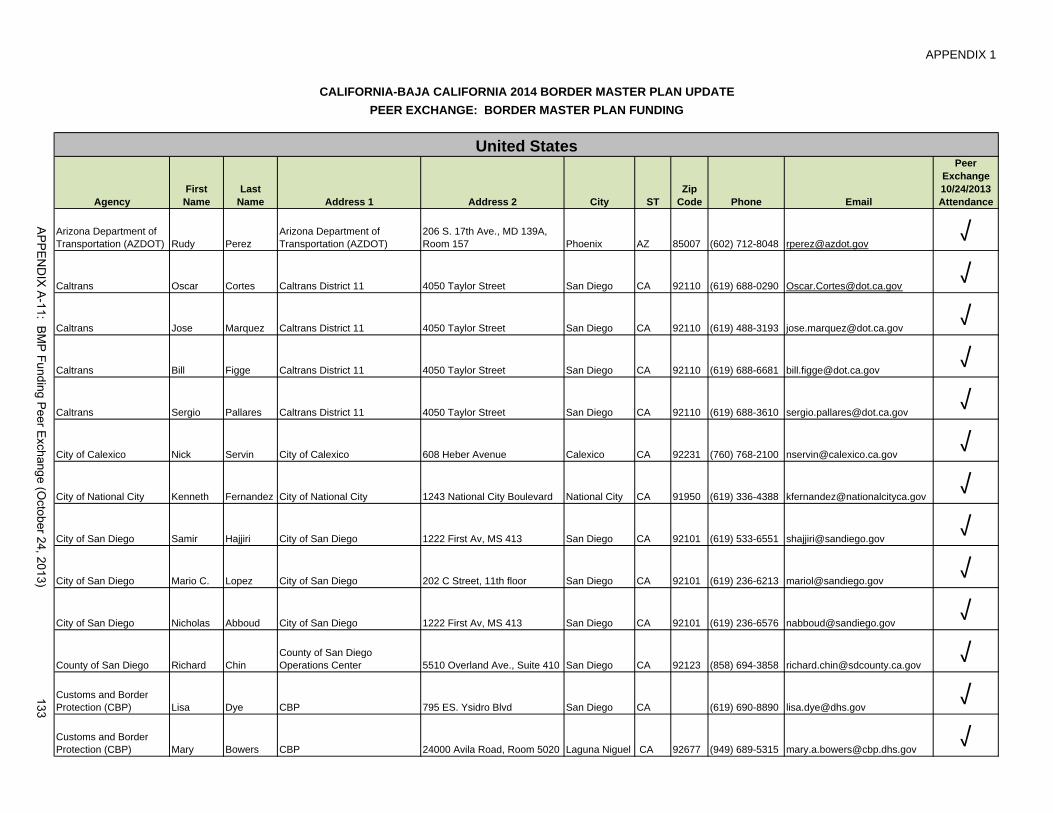
APPENDIX 1
AgencyFirst Name
Last Name Address 1 Address 2 City ST
Zip Code Phone Email
Peer Exchange 10/24/2013Attendance
Arizona Department of Transportation (AZDOT) Rudy Perez
Arizona Department of Transportation (AZDOT)
206 S. 17th Ave., MD 139A, Room 157 Phoenix AZ 85007 (602) 712-8048 [email protected] √
Caltrans Oscar Cortes Caltrans District 11 4050 Taylor Street San Diego CA 92110 (619) 688-0290 [email protected] √
Caltrans Jose Marquez Caltrans District 11 4050 Taylor Street San Diego CA 92110 (619) 488-3193 [email protected] √
Caltrans Bill Figge Caltrans District 11 4050 Taylor Street San Diego CA 92110 (619) 688-6681 [email protected] √
Caltrans Sergio Pallares Caltrans District 11 4050 Taylor Street San Diego CA 92110 (619) 688-3610 [email protected] √
City of Calexico Nick Servin City of Calexico 608 Heber Avenue Calexico CA 92231 (760) 768-2100 [email protected] √
City of National City Kenneth Fernandez City of National City 1243 National City Boulevard National City CA 91950 (619) 336-4388 [email protected] √
City of San Diego Samir Hajjiri City of San Diego 1222 First Av, MS 413 San Diego CA 92101 (619) 533-6551 [email protected] √
City of San Diego Mario C. Lopez City of San Diego 202 C Street, 11th floor San Diego CA 92101 (619) 236-6213 [email protected] √
City of San Diego Nicholas Abboud City of San Diego 1222 First Av, MS 413 San Diego CA 92101 (619) 236-6576 [email protected] √
County of San Diego Richard ChinCounty of San Diego Operations Center 5510 Overland Ave., Suite 410 San Diego CA 92123 (858) 694-3858 [email protected] √
Customs and Border Protection (CBP) Lisa Dye CBP 795 ES. Ysidro Blvd San Diego CA (619) 690-8890 [email protected] √Customs and Border Protection (CBP) Mary Bowers CBP 24000 Avila Road, Room 5020 Laguna Niguel CA 92677 (949) 689-5315 [email protected] √
CALIFORNIA-BAJA CALIFORNIA 2014 BORDER MASTER PLAN UPDATE
United States
PEER EXCHANGE: BORDER MASTER PLAN FUNDING
AP
PE
ND
IX A
-11: BM
P Funding P
eer Exchange (O
ctober 24, 2013)133

APPENDIX 1
AgencyFirst Name
Last Name Address 1 Address 2 City ST
Zip Code Phone Email
Peer Exchange 10/24/2013Attendance
CALIFORNIA-BAJA CALIFORNIA 2014 BORDER MASTER PLAN UPDATE
United States
PEER EXCHANGE: BORDER MASTER PLAN FUNDING
Department of State (DOS) Steve Kameny
Border Affairs Officer, Mexico Desk 2201 C St. NW Washington DC 20520 (202) 647 9894 [email protected] √
Environmental Protection Agency (EPA) David Fege EPA--San Diego Border Office
610 West Ash Street, Suite 905 San Diego CA 92101 (619) 235-4769 [email protected] √
Federal Highway Administration (FHWA) Manuel Sanchez
California Division United States Department of Transportation 401 B Street, Suite 800 San Diego CA 92101 (619) 699-7336 [email protected] √
Federal Highway Administration (FHWA) Sylvia Grijalva
Federal Highway AdministrationOffice of Planning
4000 North Central Ave. Suite 1500 Phoenix AZ 85012 (602) 510-7986 [email protected] √
General Services Administration (GSA) Anthony Kleppe
GSA Southern Border Station Center 450 Golden Gate Ave. 3rd fl E. San Francisco CA 94102
(415) 522-3442 /(415) 522-3474 [email protected] √
General Services Administration (GSA) Ramon D. Riesgo
National Office of Design and Construction 880 Front Street, Room 4236 San Diego CA 92101 (619) 557-5092 [email protected] √
Imperial County Transportation Commission (ICTC) Mark Baza
Imperial County Transportation Commission (ICTC) 1405 North Imperial Ave Ste. 1 El Centro CA 92243
(760) 592-4494 x201 [email protected] √
SANDAG Gary Gallegos SANDAG 401 B Street, Suite 800 San Diego CA 92101 (619) 699-1900 [email protected] √
SANDAG Muggs StollLand Use and Transportation Planning Department 401 B Street, Suite 800 San Diego CA 92101 (619) 699-6945 [email protected] √
SANDAG Christina Casgar SANDAG 401 B Street, Suite 800 San Diego CA 92101 (619) 699-1982 [email protected] √
SANDAG Jose Nuncio Finance 401 B Street, Suite 800 San Diego CA 92101 (619) 699-1908 [email protected] √Texas Department of Transportation (TxDOT) Eduardo Hagert
Texas Department of Transportation (TxDOT) Cagt 12th Street, Austin, TX Austin TX (512) 578-9346 [email protected] √
AP
PE
ND
IX A
-11: BM
P Funding P
eer Exchange (O
ctober 24, 2013)134

APPENDIX 1
AgencyFirst Name
Last Name Address 1 Address 2 City ST
Zip Code Phone Email
Peer Exchange 10/24/2013Attendance
CALIFORNIA-BAJA CALIFORNIA 2014 BORDER MASTER PLAN UPDATE
United States
PEER EXCHANGE: BORDER MASTER PLAN FUNDING
Service Bureau and SANDAG Binational Programs Hector Vanegas
Service Bureau and SANDAG Binational Programs 401 B Street, Suite 800 San Diego CA 92101 (619) 699-1972 [email protected]
√SANDAG Service Bureau Alfredo Medina Service Bureau 401 B Street, Suite 800 San Diego CA 92101 (619) 595-5366 [email protected] √SANDAG Service Bureau Elisa Arias Service Bureau 401 B Street, Suite 800 San Diego CA 92101 (619) 699-1936 [email protected] √SANDAG Service Bureau Cheryl Mason Service Bureau 401 B Street, Suite 800 San Diego CA 92101 (619) 699-1951 [email protected] √
AP
PE
ND
IX A
-11: BM
P Funding P
eer Exchange (O
ctober 24, 2013)135

APPENDIX 1
AgencyFirst Name Last Name Address 1 Address 2 City ST Zip Code Phone Email
Peer Exchange 10/24/2013Attendance
IMPLAN Alma Sevilla IMPLAN Tijuana B.C.01152664 6866241 [email protected] √
INDAABIN Salvador Lamas INDAABIN Linea Internacional S/N, Col. Federal Tijuana B.C. 22010 (664) 682- 8426 [email protected] √
INDAABIN Carlos de la Fuente INDAABIN [email protected] √
INDAABIN EliseoRosales Avalos INDAABIN √
INDAABIN Guillermo Villagómez INDAABIN Av Revolucion 642San Pedro de los Pinos Mexico D.F. 3801
(55) 56 63 26 99 ext. 112 [email protected] √
Instituto Nacional de Migracion (INAMI) Raul Pareyon
Instituto Nacional de Migracion (INAMI) Baja California Baja B.C. (664) 674-5129 [email protected] √
SCTMarco Antonio
Frias Galvan SCT
Insurgentes Sur 1089 Col. NochebuenaDeleg. Benito Juárez, Piso 10 Mexico D.F. 03720
(55) 54 82 42 00 ext 16813 [email protected] √
SIDUE Karlo Limon SIDUEEdificio Poder Ejecutivo 3 pisoCentro Cívico Mexicali B.C. 21000
(55) 686-558-1000 Ext. 1476 [email protected] √
SRE Luis JavierCastro Castro SRE
Av. Juarez #20 Piso 18, Colonia Centro Deleg. Cuauhtémoc México D.F. 06010
(55) 36 86 58 36 [email protected] √
SRERomán Alberto
Fernández López SRE
Av. Juárez #20, Colonia Centro Piso 18, Deleg. Cuauhtémoc México D.F. 06010
(55) 36 86 51 00 ext. 7630 [email protected] √
State of Tamaulipas Vicente San Martin State of Tamualipas [email protected]
Binational: NADBANK
Jose Miguel Tellechea NADBANK (Binational) [email protected]
CALIFORNIA-BAJA CALIFORNIA BORDER MASTER PLAN UPDATE PEER EXCHANGE: BORDER MASTER PLAN FUNDING
Mexico
AP
PE
ND
IX A
-11: BM
P Funding P
eer Exchange (O
ctober 24, 2013)136
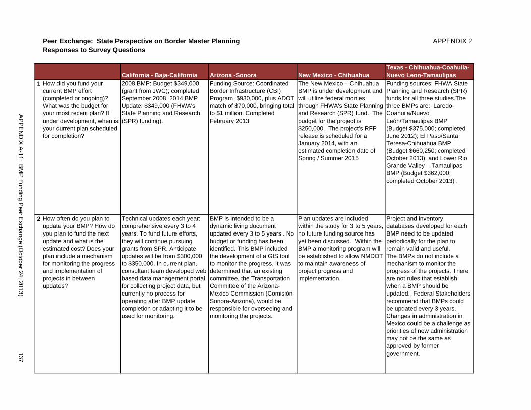
Peer Exchange: State Perspective on Border Master Planning APPENDIX 2Responses to Survey Questions
California - Baja-California Arizona -Sonora New Mexico - ChihuahuaTexas - Chihuahua-Coahuila-Nuevo Leon-Tamaulipas
1 How did you fund your current BMP effort (completed or ongoing)? What was the budget for your most recent plan? If under development, when is your current plan scheduled for completion?
2008 BMP: Budget $349,000 (grant from JWC); completed September 2008. 2014 BMP Update: $349,000 (FHWA's State Planning and Research (SPR) funding).
Funding Source: Coordinated Border Infrastructure (CBI) Program $930,000, plus ADOT match of $70,000, bringing total to $1 million. Completed February 2013
The New Mexico – Chihuahua BMP is under development and will utilize federal monies through FHWA's State Planning and Research (SPR) fund. The budget for the project is $250,000. The project’s RFP release is scheduled for a January 2014, with an estimated completion date of Spring / Summer 2015
Funding sources: FHWA State Planning and Research (SPR) funds for all three studies.The three BMPs are: Laredo-Coahuila/Nuevo León/Tamaulipas BMP(Budget $375,000; completed June 2012); El Paso/Santa Teresa-Chihuahua BMP (Budget $660,250; completed October 2013); and Lower Rio Grande Valley – Tamaulipas BMP (Budget $362,000; completed October 2013) .
2 How often do you plan to update your BMP? How do you plan to fund the next update and what is the estimated cost? Does your plan include a mechanism for monitoring the progress and implementation of projects in between updates?
Technical updates each year; comprehensive every 3 to 4 years. To fund future efforts, they will continue pursuing grants from SPR. Anticipate updates will be from $300,000 to $350,000. In current plan, consultant team developed web based data management portal for collecting project data, but currently no process for operating after BMP update completion or adapting it to be used for monitoring.
BMP is intended to be a dynamic living document updated every 3 to 5 years . No budget or funding has been identified. This BMP included the development of a GIS tool to monitor the progress. It was determined that an existing committee, the Transportation Committee of the Arizona-Mexico Commission (Comisión Sonora-Arizona), would be responsible for overseeing and monitoring the projects.
Plan updates are included within the study for 3 to 5 years, no future funding source has yet been discussed. Within the BMP a monitoring program will be established to allow NMDOT to maintain awareness of project progress and implementation.
Project and inventory databases developed for each BMP need to be updated periodically for the plan to remain valid and useful. The BMPs do not include a mechanism to monitor the progress of the projects. There are not rules that establish when a BMP should be updated. Federal Stakeholders recommend that BMPs could be updated every 3 years. Changes in administration in Mexico could be a challenge as priorities of new administration may not be the same as approved by former government.
AP
PE
ND
IX A
-11: BM
P Funding P
eer Exchange (O
ctober 24, 2013)137

California - Baja-California Arizona -Sonora New Mexico - ChihuahuaTexas - Chihuahua-Coahuila-Nuevo Leon-Tamaulipas
3 What does your plan recommend regarding institutionalizing the border master planning process? In your opinion, why is it important to institutionalize it? What issues do you think it would resolve?
The 2008 BMP recommended that the PAC would meet every year and would reach out to JWC, BBBXG and Border Liaison Mechanisms and Border Governors Conferences to request funding. Building new POEs is finite; BMPs may migrate into operations for optimizing POE infrastructure and model development for conducting sensitivity analysis. It is important to institutionalize the BMPs as they provide a systematic approach to binational border planning at all levels of governments. It facilitates resource maximization for land POEs and connecting transportation facilities. It provides continuity in the project development and planning in a continuously changing environment. It levels the playing field among the projects and the communities that they serve. The BMP is the only known binational prioritization effort for POEs and connecting transportation projects so this adds importance to institutionalizing the effort.
Declaration of Cooperation. Governor Brewer from Arizona and Governor Padres from Sonora. Federal, State and Regional Planning. JWC, BBBXG, State Transportation Improvement Program (STIP). Arizona-Mexico Commission (AMC) Yuma Metropolitan Planning Organization (YMPO) Pima Association of Governments (PGA)
Institutionalizing a border master planning process can provide a more efficient method of overseeing projects with a creation of a single database for projects. Also, by institutionalizing the process the overseeing agency can become an advocate for funding sources, and possible activist for political awareness and assistance.
BMP opens lines of communication with stakeholders. All three BMPs recommend an annual meeting of local Policy Advisory Committees (PAC) or Binational Advisory Committee (BNAC) – voting members - to review and determine the need of updating the each planInstitutionalizing the process would allow to always have an updated quick reference guide regarding border infrastructure and key projects to the State of Texas
AP
PE
ND
IX A
-11: BM
P Funding P
eer Exchange (O
ctober 24, 2013)138

California - Baja-California Arizona -Sonora New Mexico - ChihuahuaTexas - Chihuahua-Coahuila-Nuevo Leon-Tamaulipas
4 Do you feel a permanent funding source is needed to support the border master planning process? What benefits or advantages could result from permanent funding?
Permanent funding is needed. In this environment of limited public funds, we will need to seek out innovative financing. The private sector and the banks require certainty in investments and without a systematic and reliable planning process, there is no money from the private sector. So it is a way for both countries to leverage pubic efforts with the pursuit of private sector partnerships.
Yes. A single permanent funding source could provide a quicker and easier method to access funding for BMP updates or future BMP studies. Instead of each state having to proceed with their individual funding processes, which for some states it can delay the project, a single permanent funding source could provide a faster avenue for a funding.
A permanent funding source is recommended.Possibly establishing an independent funding account, such as the Border Technology Exchange Program (BTEP) funds that could be set aside every year or bi-annually to fund BMP updates and ensure continuation of these binational efforts.Permanent BMP funding allows agencies to keep updated and aware of all binational border initiatives and projects, and ranked regional priorities.BMP documents provide a technical ground to pursue and apply for federal funding. .
AP
PE
ND
IX A
-11: BM
P Funding P
eer Exchange (O
ctober 24, 2013)139

California - Baja-California Arizona -Sonora New Mexico - ChihuahuaTexas - Chihuahua-Coahuila-Nuevo Leon-Tamaulipas
5 How was your BMP incorporated into federal, state, or regional planning efforts or initiatives?
Caltrans has used the BMP in the Caltrans District System Management Plan. It is an input to the California Transportation Plan and to the California Freight Mobility Plan. SANDAG has referenced the BMP into its legislative program that the SANDAG Board approves every year to evaluate legislative proposals It is referenced in the Regional Transportation Plan that is updated every four years. ICTC uses BMP to prioritize all types of transportation projects. It allowed ICTC to be consistent with their long range transportation plan and improve communication with federal and state agencies for planning purposes. Strategic plans in Baja California consider the BMP including the Plan Estratégico Metropolitano. IMPlan has referenced the BMP in local plans.
Arizona includes the projects in their State Transportation Improvement Program and Arizona’s Five Year Construction Program of ADOT. Transportation committee of the Arizona-Mexico Commission (Comisión Sonora-Arizona) meets four times a year and will be responsible for ensuring the monitoring and updating the BMP project information. Also in addition to the two states coordinating each other and they also coordinate with the MPOs and COGs including the Yuma Metropolitan Planning Organization, Pima Association of Governments, and the Southeastern Arizona Governments Organization (SEAGO). Their intent was to have as many BMP projects as possible be included in the MPO transportation plans too.
The New Mexico-Chihuahua BMP has been incorporated into the NMDOT 2014 State Annual Planning Work Program.
Border master plan efforts are currently JWC initiatives. They are not regulated by code. Could have more stability if regulated. Although included in the list of border priorities negotiated at the presidential level (Bilateral Action Plans) the plans have not yet been mandated/ regulated by code.Thus, no formal incorporation is required. Recommends that the preparation of BMPs be incorporated into a law so there will be more stability.
AP
PE
ND
IX A
-11: BM
P Funding P
eer Exchange (O
ctober 24, 2013)140
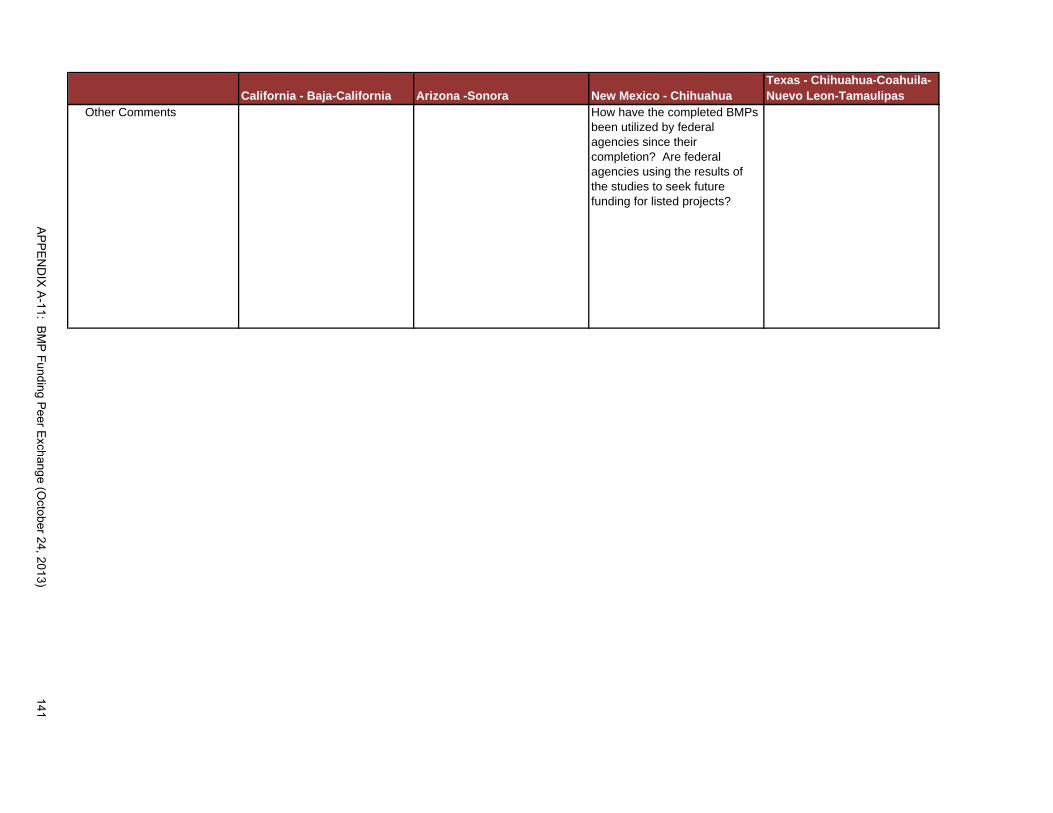
California - Baja-California Arizona -Sonora New Mexico - ChihuahuaTexas - Chihuahua-Coahuila-Nuevo Leon-Tamaulipas
Other Comments How have the completed BMPs been utilized by federal agencies since their completion? Are federal agencies using the results of the studies to seek future funding for listed projects?
AP
PE
ND
IX A
-11: BM
P Funding P
eer Exchange (O
ctober 24, 2013)141
APPENDIX 3
White Paper Border Master Planning:
U.S.-Mexico Binational Entities and Other Binational Mechanisms Revised Draft, February 27, 2014
Border master planning efforts have taken place in the past few years to help improve efficiency and effectiveness of port of entry (POE) and transportation facilities across the international border and to align priorities and efforts in both countries. Ensuring the continuity of the regional border master planning process is a natural next step while addressing the dynamic nature of the international border. A discussion on elaborating on the need and value of the border master planning process and how to fund it moving forward has become relevant. These topics will be explored in the peer exchange panel.
This paper includes a list of the Border Master Plans (BMPs) that are under development or completed along the U.S.-Mexico border and provides examples of binational entities established to address diverse binational issues. This white paper is meant to serve as background information for the peer exchange.
BORDER MASTER PLAN (BMP) STUDIES
Crossborder travel at the land POEs along the U.S.-Mexico international border has grown significantly over the years. Efforts to improve the capacity and operations of the current infrastructure is critical to decrease traffic congestion and delays, facilitate international trade, and improve the quality of life for residents in the border region.
The U.S.-Mexico Joint Working Committee (JWC) is working in collaboration with partner agencies to create a compendium of regional master plans with a comprehensive and prioritized assessment of POE and transportation needs and projects along the U.S.-Mexico border in each region. BMP studies along the border have been completed or are currently under development. These efforts are done in collaboration with the JWC; U.S. Department of State (DOS); U.S. Federal Highway Administration (FHWA); Mexico Secretariat of Foreign Relations (Secretaría de Relaciones Exteriores (SRE)); Mexico Secretariat of Communications and Transportation (Secretaría de Comunicaciones y Transportes (SCT)); and well as other federal, state, regional, and local governments. Following is a list of the BMP efforts that have been completed or that are under development.
• Arizona-Sonora BMP (Completed 2012)
• California-Baja California BMPs o Initial report (Completed 2008) o 2014 BMP Update (Under Development)
• New Mexico-Chihuahua BMP (Under Development)
• Texas and Coahuila-Nuevo León-Tamaulipas-Chihuahua BMPs o Laredo—Coahuila/Nuevo León/Tamaulipas (Completed 2012) o El Paso/Santa Teresa—Chihuahua (Completed 2013) o Lower Rio Grand Valley—Tamaulipas (Under Development)
APPENDIX A-11: BMP Funding Peer Exchange (October 24, 2013)142

APPENDIX 3 U.S.-MEXICO BINATIONAL ENTITIES AND MECHANISMS
The section provides a concise summary of the history, mission and objectives, scope of work, membership and organization, and funding structure of binational border institutional collaboration mechanisms that have been created between Mexico and the United States in order to address important joint issues. This section is divided into two parts. The first part describes binational entities and the second discusses other binational mechanisms.
Binational Entities
Border Environment Cooperation Commission (BECC) or Comisión de Cooperación Ecológica Fronteriza (COCEF)
History: The Border Environment Cooperation Commission (BECC), or La Comisión de Cooperación Ecológica Fronteriza (COCEF) in Spanish, is a binational institution created by the U.S. and Mexico in 1993 under an environmental side-agreement to the North American Free Trade Agreement (NAFTA).
Mission: BECC’s mission is “to preserve and enhance environmental conditions and quality of life for people living along the U.S.-Mexico border” by effectively applying binational policies and programs that support the sustainable development of environmental infrastructure in the border region.
Objectives and Scope of Work: The original mandate focused on water pollution and conservation, wastewater, waste management and recycling, and was later expanded to include air quality, clean and efficient energy, public transportation and municipal planning and development. More recently, the following sectors have been added to the scope of BECC’s mandate: International border crossings; energy transmission and distribution; production of goods and services to enhance or protect the environment; and infrastructure projects to minimize future negative environmental impacts in the region. The institution’s objectives include the following: certifying the technical feasibility and the environmental - health impacts of projects; ensuring transparency and promoting community-based support for projects; and providing technical assistance for project development. Project jurisdiction in the border region is defined as the area located within 100 kilometers (about 62 miles) north of the international boundary and 300 kilometers (about 186 miles) south of the border. As of March, 2013, BECC has completed 209 certified projects, corresponding to $6.387 billion dollars in environmental infrastructure projects in Mexico and the U.S.
Membership and Organization: BECC shares a Board of Directors with its sister institution, the North American Development Bank (NADB). The Board is a structure of binational organizations in which civil society is represented. The Board consists of the following five member agencies from Mexico: Ministry of Finance and Public Credit (Secretaría de Hacienda y Crédito Público (SHCP)); Ministry of Foreign Affairs (Secretaría de Relaciones Exteriores (SRE)); Ministry of the Environment and Natural Resources (Secretaría de Medio Ambiente y Recursos Naturales (SEMARNAT)); a border state representative from the State of Baja California; and a border public representative. U.S. member agencies are the following: Department of The Treasury; Department of State; Environmental Protection Agency (EPA) a border state representative; and a border public representative. The chairmanship of the board alternates between U.S. and Mexican representatives every year.
Under the direction of the joint BECC-NADB Board of Directors, day-to-day operations at BECC are overseen by a general manager and a deputy general manager. This leadership team is comprised of a national of either the U.S. or Mexico, enforcing the model for binational teamwork. BECC and NADB also work closely with other border stakeholders including federal, state, and local agencies, the private-sector
APPENDIX A-11: BMP Funding Peer Exchange (October 24, 2013) 143

APPENDIX 3 and civil society to identify, develop, finance and implement environmental infrastructure projects on both sides of the U.S.-Mexico border.
Funding Structure: BECC's operating budget is funded by federal contributions from Mexico, through SEMARNAT, and from the U.S., through the Department of State.
In addition to its operating budget, BECC manages the Project Development Assistance Program (PDAP), and the Border Environmental Infrastructure Fund (BEIF), which allocate grants from the EPA for municipal drinking water and wastewater projects through the U.S.-Mexico Border Water Infrastructure Program. These grant programs help supplement loans and guaranties for communities that cannot afford to fund projects solely through credit financing. In addition, BECC manages several environmental management initiatives funded by the EPA through the Border 2012 Program. To ensure funds are used efficiently, BECC and the EPA conduct a biannual prioritization process to rank project funding applications. To off-set the resources required to manage these border programs, EPA provides an administrative subsidy to BECC, which supplements its normal operating budget.
Another source of funding for BECC projects on both sides of the border is NADB, which was created at the same time as BECC in order to concentrate on project financing and oversight for project implementation. NADB offers direct low-cost financing in the form of loans and grants to public and private entities for the implementation of BECC certified projects. Currently, NADB has four lending mechanisms to support environmental infrastructure projects: a traditional loan program offering low or at market interest rates; a Border Environmental Infrastructure Fund (BEIF), which allocates grants from the EPA for municipal drinking water and wastewater projects; a Solid Waste Environmental Program (SWEP); and a Water Conservation Investment Fund (WCIF). The total authorized capital of NADB is $3 billion with equal commitments from the United States and Mexico.
The North American Development Bank (NADB) or El Banco de Desarrollo de América del Norte (BDAN)
History: The North American Development Bank (NADB), or El Banco de Desarrollo de América del Norte (BDAN) in Spanish, was created by Mexico and the U.S. in 1993 under a side environmental agreement to the North American Free Trade Agreement (NAFTA). NADB was created to serve as the financing arm of its sister institution, The Border Environment Cooperation Commission (BECC) or La Comisión de Cooperación Ecológica Fronteriza (COCEF) in Spanish, described above. NADB began operations in November, 1994, with the initial capital subscriptions of the U.S. and Mexican governments.
Mission: NADB’s mission is a joint effort with BECC “to preserve and promote the health and welfare of the border environment and its residents.” Its specific role is to facilitate financing for the development, execution and operation of environmental infrastructure projects that have been certified by BECC. The institution’s services include acting as a financial advisor and strategist, an investment banker and lender. Its objectives are: “To assist border communities in making a gradual transition from projects that are fully subsidized by grants and government budget allocations to projects that are fiscally sound and locally sustainable; and to build “strong partnerships with stakeholders at every level, including border residents, project sponsors, municipal utility managers, local, state, and federal elected officials, government agencies and programs, non-governmental organizations, and the private sector.”
Objectives and Scope of Work: NADB is authorized to finance projects within the U.S.-Mexico border region, defined as the area within 100 kilometers (about 62 miles) north of the international boundary and 300 kilometers (about 186 miles) south of the border. Under the charter between BECC and NADB, amended in August 2004, NADB is “authorized to finance projects that will prevent, control or reduce environmental pollutants or contaminants, improve the drinking water supply, or protect flora and fauna, so as to improve human health, promote sustainable development, or contribute to a higher quality of
APPENDIX A-11: BMP Funding Peer Exchange (October 24, 2013)144

APPENDIX 3 life.” NADB typically finances the following types of projects: water, waste management, cleaner and renewable energy, air quality, industrial and hazardous waste, and energy efficiency. Since its inception, NADB has managed approximately $1.91 billion to finance 171 certified projects estimated to cost of $5.12 billion to build.
Membership and Organization: NADB’s Board of Directors is a joint Board with BECC. See section under BECC for a description of the membership and management.
Funding Structure: The total authorized capital of NADB amounts to $3 billion, with equal commitments from the U.S. and Mexico. Each country authorized the subscription of 150,000 shares of the bank’s capital stock with a par value of $10,000 per share. 15 percent of the authorized capital is in the form of paid-in capital, which consists of actual cash funds contributed to the NADB by the two governments. The remaining 85 percent is in the form of callable capita, which is composed of funds, which the governments must provide to the NADB in the future, if required to meet outstanding debt obligations of the NADB or guaranties issued by the NADB.
As established in its charter, 90 percent of NADB’s authorized capital is used to finance environmental infrastructure projects in the border region, and 10 percent of the capital subscribed by each country is used to finance community adjustment and investment throughout the United States and Mexico in support of the purposes of NAFTA. Of the $450 million in paid-in capital, $405 million relates to the environmental infrastructure program, while the remaining $45 million was evenly divided between the two countries for their respective domestic program. The costs of borrowing and bank operations, as well as credit risk coverage, determine the rate at which the NADB can lend.
International Boundary and Water Commission (IBWC) or La Comisión Internacional de Límites y Aguas (CILA)
History: The International Boundary and Water Commission, United States and Mexico (IBWC) wasfirst established as the International Boundary Commission in 1889 by the two countries to address boundary and related issues along the U.S. Mexico border established by the 1848 Treaty of Hidalgo. The IBWC is an international body composed of two national sections, the Spanish-language name for the IBWC is La Comisión Internacional de Límites y Aguas or CILA.
The IBWC emerged into its modern form as a result of the 1944 Treaty concerning "Utilization of Waters of the Colorado and Tijuana Rivers and of the Rio Grande." The treaty established that the IBWC shall in all respects have the status of an international body and that the head of each Section be an Engineer Commissioner and that wherever Treaty provisions called for joint action or joint agreement by the two Governments, such matters would be handled by or through the Department of State of the United States and the Ministry of Foreign Affairs of Mexico (Secretaría de Relaciones Exteriores (SRE)).
Mission: The IBWC’s overall is “to apply the boundary and water treaties between the two countries and to settle any differences that arise in their application.”
Objectives and Scope of Work: The organization’s specific objective is to “apply the rights and obligations which the Governments of the U.S. and Mexico assume under the numerous boundary and water treaties and related agreements, and to do so in a way that benefits the social and economic welfare of the peoples on the two sides of the boundary and improves relations between the two countries.” As provided for in the treaties and agreements, those ‘rights and obligations’ include: distribution between the two countries of the waters of the Rio Grande (named Río Bravo in Mexico) and of the Colorado River; regulation and conservation of the waters of the Rio Grande for their use by the two countries by joint construction; operation and maintenance of international storage dams and reservoirs and plants for generating hydroelectric energy at the dams; regulation of the Colorado River
APPENDIX A-11: BMP Funding Peer Exchange (October 24, 2013) 145

APPENDIX 3 waters allocated to Mexico; protection of lands along the river from floods by levee and floodway projects; solution of border sanitation and other border water quality problems; preservation of the Rio Grande and Colorado River as the international boundary; and demarcation of the land boundary.
Membership and Organization: The IBWC is an international body composed of the U.S. Section and the Mexican Section, each headed by an Engineer-Commissioner appointed by his/her respective president. Each Section is administered independently of the other. The U.S. Section is a federal government agency and is headquartered in El Paso, Texas and operates under the foreign policy guidance of the Department of State. The Mexican Section is under the administrative supervision of SRE and is headquartered in Ciudad Juárez, Chihuahua, Mexico.
Each Section maintains its own engineering staff, a secretary and legal advisers. Each Section also has field offices strategically located along the border to operate and maintain joint works and provide support in resolving binational issues.
Funding Structure: Each Government funds the cost of the operation of its Section of the IBWC, while the cost of joint projects is generally shared between the U.S. and Mexican Governments; the two Governments share the total costs of the projects in proportion to their respective benefits therefrom.In cases of man-made works or operations in one country country causing or threatening to cause damage in the other country, the cost is borne by the Government in whose territory the problem originated.
U.S. – Mexico Border Health Commission (BHC)
History: In recognition of the need for an international commission to address border health issues, the U.S.-Mexico Border Health Commission (BHC) was created as a binational health commission in July 2000, with the signing of an agreement by the Secretary of Health and Human Services of the U.S. and the Secretary of Health of Mexico. In December, 2004, the BHC was designated as a Public International Organization by Executive Order of the President.
Mission: The mission of the BHC is: “To provide international leadership for developing coordinated and binational actions that optimize health and quality of life along the U.S.-Mexico border; and “to eliminate health disparities through an effort that focuses attention on regional health issues.” The BHC works to promote sustainable partnerships, bringing together government and non-governmental organizations, academic institutions, and public and private stakeholders.
Objectives and Scope of Work: The BHC’s two primary objectives are to institutionalize a domestic focus on border health that can transcend political changes, and to create an effective venue for binational discussion to address the public health issues and problems affecting the U.S.-Mexico border populations. To accomplish these goals, the BHC facilitates identification of public health issues; supports studies and research on border health, and brings effective federal, state, and local public/private resources together by forming dynamic partnerships and alliances to improve the health of the border populations through creative, multi-sectorial approaches.
Key priority areas for the BHC include access to care, obesity and diabetes, tuberculosis, strategic planning, infectious disease and public health emergencies, research, data collection, and academic alliances.
Membership and Organization: The BHC is comprised of the federal secretaries of health, the chief health officers of the ten border states, and prominent community health professionals from both nations. The Mexican Section of the BHC is composed of: The Mexican Secretary of Health or his/her delegate, as Commissioner; one member from each of the six border states, who is designated by Mexico’s Secretary of Health; and the State Secretaries of Health of Baja California, Sonora, Chihuahua, Coahuila, Tamaulipas, and Nuevo León, or their respective delegates. The U.S. Section of the BHC is composed of:
APPENDIX A-11: BMP Funding Peer Exchange (October 24, 2013)146

APPENDIX 3 The U.S. Secretary of Health and Human Services, or his/her delegate, as Commissioner; two individuals from each of the border states, who are nominated by their respective governor and appointed by the U.S. President; and The Commissioner of Health or Chief Health Officer from the States of Arizona, California, New Mexico and Texas, or their respective delegates.
Practicing health care professionals or members of the academic/research community also contribute as individual members to offer an important cross-section of border population health needs and experiences at the local level and link with a multitude of stakeholders within a given community.
The ten state health officers from the border states act as ex-officio members, addressing current and emerging public health challenges, enabling states’ health policymakers and technical experts to share experiences and lessons learned, and implementing changes within their respective states in a more coordinated approach regarding border health issues. The state health officers and the health departments they represent have extensive contacts and networks with multi-community stakeholders from the public and private sectors that enable dialogue and information exchange at the local level.
The Office of Global Affairs within the Office of the Secretary, U.S. Department of Health and Human Services (HHS) in Washington D.C., and the General Directorate for International Relations of the Mexican Ministry of Health (Secretaría de Salud (SS)) in Mexico, D.F., serve as the federal points of coordination for the BHC.
Funding Structure: The BHC receives ongoing annual federal appropriations and support for its Work Plan and Budgets through HHS on the U.S. side and the SS on the Mexican side.
Other Binational Mechanisms
U.S. - Mexico Joint Working Committee (JWC)
History: The U.S.-Mexico JWC has its roots in the onset of the North American Free Trade Agreement (NAFTA) between the U.S., Canada, and Mexico, which entered into force on January 1, 1994. In anticipation of expanding economic and commercial relations associated with the NAFTA, the U.S. and Mexico recognized the need for a well-coordinated transportation planning process in the border region. On April 29, 1994, the U.S. Department of Transportation (DOT) and the Mexican Ministry of Communications and Transportation (Secretaría de Comunicaciones y Transportes, (SCT)), signed a Memorandum of Understanding (MOU), which established the JWC. A second binational MOU was signed in October 2000. This MOU was developed to strengthen the working relationship developed over the years and provided direction for the group in the future. Goals of the second MOU included stimulating and promoting innovative methods to improve the safe, efficient, and economical crossborder movement of people and goods and closely coordinating between the entities involved in the JWC.
Mission: The JWC’s primary focus is to facilitate efficient, safe, and economical crossborder transportation movements and cooperate on land transportation planning.
Objectives and Scope of Work: The JWC’s main objectives are to promote effective communication and coordination; analyze current and future transportation infrastructure needs; and evaluate transportation demand and infrastructure impacts. A chief area of focus for the JWC is the development and coordination of Regional Border Master Plans between the United States and Mexico. The JWC is working with partner agencies to create a compendium of border-wide regional master plans with a comprehensive and prioritized assessment of transportation needs along the border including the POEs. Another recent activity includes conducting workshops on greening transportation at the border. The workshops focused on four border transportation themes: green technology, performance/reliability measures, livability/sustainability, and green financing/industry. Other JWC work plan priorities include a
APPENDIX A-11: BMP Funding Peer Exchange (October 24, 2013) 147

APPENDIX 3 U.S.-Mexico Border Wait-time Peer Exchange Roundtable, with the goal being to reduce border wait-times and congestion at international border POEs, as well as an analysis between border wait times and emissions to evaluate environmental impacts.
Membership and Organization: The group is mostly comprised of transportation professionals from the FHWA and the SCT, and also includes representatives from the U.S. Department of State (DOS), the Mexican Ministry of Foreign Affairs of Mexico (Secretaría de Relaciones Exteriores (SRE)), the four U.S. border states DOTs, and the six Mexico border States. The General Services Administration (GSA) and Customs and Border Protection (CBP) of the Department of Homeland Security also participate in JWC meetings, as well as their Mexican counterparts. The members meet twice a year to develop and implement work plans and address border issues. For purposes of coordination and information, the JWC keeps the United States - Mexico Bilateral Committee on Bridges and Border Crossings informed of its findings by formal presentations twice a year and interim reports as necessary.
Funding Structure: According to the MOU, each member country contributes towards the budget of the JWC by paying its respective costs.
U.S.-Mexico Binational Bridges and Border Crossings Group (BBBXG)
Mission: To provide a forum for a binational effort to manage the planning, construction, and maintenance of planned, ongoing or new border crossing projects and POEs along the 1,952 mile U.S.-Mexico border.
Objectives and Scope of Work: The purpose of the BBBXG’s semi-annual meetings is to discuss operational matters involving existing and proposed bridges and border crossings and their related infrastructure, and to exchange views on policy as well as technical information. Related issues involving facilitation of travel between the two countries, such as border region highways and other infrastructure projects, are also discussed.
Membership and Organization: This group is co-chaired by the Department of State and the Mexican Ministry of Foreign Affairs of Mexico (Secretaría de Relaciones Exteriores (SRE)), and is attended by federal agencies with an interest in border crossings such as: Customs and Border Protection (CBP); Department of Homeland Security (DHS); General Services Administration (GSA); U.S. Coast Guard; Animal Plant Health Inspection Service (APHIS); Food and Drug Administration (FDA); Federal Highway Administration (FHWA); Federal Railroad Administration, (FRA); International Boundary and Water Commission (IBWC); the respective departments of transportation and border authorities of the Border States and their corresponding agencies in Mexico. The State Department is the U.S. co-chair because it is the federal agency responsible for the Presidential permitting process required for new crossings and substantial modifications to existing border crossings. The ten U.S. and Mexican border states are active participants in these meetings.
The BBBXG holds annual meetings at locations along the border, rotating between the states and countries. BBBXG meetings generally consist of three separate sections: Separate U.S. and Mexican delegation meetings where general issues are discussed; a public session individuals or organizations can make presentations to the group, including proposals for new crossings; and a government-only technical session, where the binational group discusses the status of ongoing border crossing projects and related issues. There is one border-wide BBBXG meeting and two regional BBBXG meetings annually.
Funding Structure: The SRE and the Department of State alternate hosting the BBBXG’s meeting venues. Attendees fund their own participation.
APPENDIX A-11: BMP Funding Peer Exchange (October 24, 2013)148
APPENDIX 3 Border Liaison Mechanism (BLM)
History: The Border Liaison Mechanism (BLM) was developed in response to a growing need for institutionalized border cooperation. It was established in 1992 as a result of a bilateral agreement between the U.S. and Mexico calling for the formation of crossborder meetings of federal, state and local authorities organized and chaired by principal officers from both countries. The BLM was established in the San Diego-Tijuana region in 1993.
Mission: To enhance crossborder communication, ensure that unique local issues are not overlooked by the federal governments and address local issues directly without guidance from the capitals.
Objectives and Scope of Work: To enable the consuls of Mexico and the U.S. in the border cities to convene state, local, and federal agency representatives and others from both sides of the border to formally discuss matters of mutual interest, including ports of entry security, public health, immigration, public safety coordination, natural resources, health, and the environment. BLMs hold both regularly-scheduled meetings and emergency meetings in the event of any important border incident; emergency meetings have dealt with problems arising from bridge blockades and incidences of violence.
The BLM in the San Diego-Tijuana-Tecate region has worked for years on transborder water issues, including shared water infrastructure and water resource management.
Membership and Organization: Chaired by U.S. and Mexican consuls, the BLMs include U.S. and Mexican civic leaders, inspection agency representatives and law enforcement contacts who meet to share information and discuss problems. The meetings were to be alternatively held on the American and Mexican sides of the border, with each principal officer jointly responsible for determine the agendas. The BLMs operate in "sister city" pairs, which exist in Tijuana-San Diego, Calexico-Mexicali, Nogales-Hermosillo, Ciudad Juárez-El Paso, Laredo-Nuevo Laredo, Matamoros-McAllen, and Matamoros-Brownsville. Additional BLMs are being planned. Due to the increasing number of issues dealt with by the BLM, and the length of the plenary meetings, subgroups or baskets focused on issues such as border security, migration, bridges and border crossings and the environment were created.
Funding Structure: No specific details on funding were found, however, federal funds are appropriated to the BLM through respective U.S. and Mexican federal agencies.
Border Governors Conference (BGC)
History: The U.S.-Mexico Border Governors Conference (BGC) first convened in the 1960’s and was formalized in 1980, and consists of annual binational meetings between the governors of the four American states and the six Mexican states that form the U.S.-Mexico border region.
Mission: To establish a mechanism for ongoing dialogue and consultation, as well as a close working relationship among the border Governors in order to generate binational cooperation between the states, for the prosperity and improvement of the quality of life for the inhabitants of the region.
Objectives and Scope of Work: At BGC conferences, Governors discuss state and regional issues and opportunities and coordinate policy-making efforts by signing letters and Memorandums of Understanding, which are typically addressed to the federal governments of each country. Governors also identify objectives for their agendas through the signing of a joint declaration. The Governors agreed on focusing on the following topics: Agriculture; Water; Tourism; Science and Technology; Border Crossings; Economic Development; Education; Energy; Environment; Wildlife Health; Border Security; and Tourism.
Membership and Organization: The BGC does not have a permanent staff or headquarters, but holds annual binational meetings including the ten border state Governors from both sides of U.S.-Mexican
APPENDIX A-11: BMP Funding Peer Exchange (October 24, 2013) 149
APPENDIX 3 border, along with their respective Secretaries, Directors, Commissioners and designated staff, as well as other stakeholders of both countries. The chair and vice chair of the BGC alternate between U.S. and Mexico border states, and the chair typically hosts the meeting in their respective state. At the Conferences, the BGC policy strategies are developed, evaluated and implemented through the Border Governors Representatives and Work Tables, comprised by key state officials from each of the border states, under the four policy areas. The conferences typically last two to three days and the location alternates between the member states. In addition to the annual conference, the worktables meet at least twice during the year to discuss and develop the worktable’s recommendations and action plans.
Funding Structure: No specific details on funding were found.
U.S. - Mexico Binational Commission (BNC)
History: In May, 1977, U.S. President Carter and Mexican President Lopez Portillo established the precursor to the U.S.-Mexico Binational Commission (BNC) to provide better coordination of U.S.-Mexico relations. Then called the U.S. Mexico Consultative Mechanism, it had three broad working groups: political, social and economics; and subgroups within each of these. The BNC was renamed and established by Presidents Reagan and Lopez Portillo in 1981 to serve as a forum for meetings between cabinet-level officials from both countries.
Mission: The BNC is a forum established by the U.S. and Mexico to allow for regular exchanges at the cabinet-level on a wide range of issues critical to relations between the two countries.
Objectives and Scope of Work: The BNC has working groups on agriculture; border cooperation; business development, fisheries, and tourism; education and cultural affairs; energy; environment and natural resources; fiscal, financial, and customs issues; health; labor; legal affairs and anti-narcotic issues; migration and consular affairs; science and technology; trade and investment; and transportation. Some accomplishments of the BNC include improved trade cooperation which led to greater market access for some U.S. products. Other accomplishments include Mexico’s commitment to improve border inspection services for U.S. livestock and grains. The group also established plans of actions to continue the exchange of information on new development between topics such as agricultural biotechnology, animal health law, and the electronic transfer of documents.
Membership and Organization: The BNC is composed of numerous U.S. cabinet members, agency chiefs, and their Mexican counterparts, who meet for intensive one-or-two-day discussions on an annual basis.
Funding Structure: Mexico and the U.S. bear the respective cost of their participation and implementation of the BNC, including the expenses of personnel who participate in any activity undertaken on the basis of it. For the training of personnel, the transfer of equipment and the construction of installations related to the BNC, the two countries may agree on a special modality of financing.
Border Legislative Conference (BLC)
History: The Border Legislative Conference (BLC) was created based on the Border Legislative Initiative (BLI), a joint effort on behalf of the Council of State Governments (CSG) - WEST and its regional partner in the South, the Southern Legislative Conference (SLC). The BLC’s inaugural forum took place in San Diego, California on March 18-19, 2002, where public and private sector representatives from the U.S. and Mexico who briefed state legislators from both nations.
Mission: To serve “as a mechanism for on-going dialogue in order to enhance the collaboration and communication among state legislators of the U.S. and Mexico.”
APPENDIX A-11: BMP Funding Peer Exchange (October 24, 2013)150

APPENDIX 3 Objectives and Scope of Work: The BLC “fosters the development of shared solutions along the border region through joint consideration of common problems and exchange of information. The BLC also seeks to establish efficient and strategic collaborative efforts with multi-level governments and non-governmental organizations to the end that border communities and state governments on both sides of the border may be strengthened and improved.” BLC forums are conducted at least twice during a calendar year and may also sponsor periodic regional issue conferences, the focus and frequency of which shall be determined by the officers. The BLC works through the following committees: Economic Development, Environment, Health, Agricultural, and Border Security. The membership of the BLC may also, from time to time, establish task forces in substantive areas of continuing interest to the member states and affiliate members.
Membership and Organization: The BLC is comprised of legislators from the ten states along the U.S. - Mexico border. Up to four members may be selected by each state, including two alternates. Membership may, upon the approval of the Border Legislative Conference members, be expanded to include non-border states as “affiliate members” from both the U.S. and Mexico, though voting privileges are reserved for legislators representing U.S.-Mexico border states. The chair and vice chair positions rotate between U.S. and Mexico border states. The staff of CSG-WEST and the SLC provide the administrative support of the program, including the coordination and organization of forums, preparation of recommendations and analysis, and the implementation of policies and actions as directed by participating legislators. Program staff consists of a Director of International Programs, two International Project Coordinators and support staff from CSG’s Western, Southern and Washington, D.C. offices.
Funding Structure: Financial support for the program is provided by a grant from the U.S. Agency for International Development (USAID).
Twenty-First Century Border Bilateral Executive Steering Committee (ESC)
History: In April, 2010, the governments of Mexico and the U.S. issued a Declaration on Twenty-First Century Border Management, based on “a shared interest in creating a border that promotes their economic competitiveness and enhances their security through the secure, efficient, rapid, and lawful movement of goods and people.” The two countries agreed to work in a collaborative and coordinated fashion across a wide-range of border-related activities. In order to coordinate and facilitate the work required to meet the goals of the Declaration, the Twenty-First Century Border Bilateral Executive Steering Committee (ESC) was formed as the implementation and oversight mechanism.
Mission: To coordinate and facilitate the work required to meet the goals of the Declaration on 21st Century Border Management.
Objectives and Scope of Work: The ESC is committed to improving infrastructure, facilitating legitimate trade and travel, and strengthening security cooperation on our common border. Under the ESC, there are three working groups: Infrastructure, Secure Flows, and Law Enforcement and Security Cooperation.
Membership and Organization: The ESC, chaired on the U.S. side by the National Security Staff and on the Mexican side by the Secretaria de Relaciones Exteriores, is composed of representatives from the following U.S. federal departments: State, Homeland Security, Justice, Transportation, Agriculture, Commerce, Interior, Defense, and the Office of the United State Trade Representative. Mexico is represented by the Ministries of Foreign Relations, Interior, Finance and Public Credit, Economy, Public Security, Communications and Transportation, Agriculture, and the Office of the Attorney General of the Republic. The ESC meets periodically and creates annual action plans, through which Mexico and the U.S. collaborate improve infrastructure, develop joint security strategies and facilitate the secure and efficient flow of goods and people.
APPENDIX A-11: BMP Funding Peer Exchange (October 24, 2013) 151
APPENDIX 3 Funding Structure: Each agency funds its own participation.
Mexico - U.S. Interparliamentary Group (IPG)
History: The creation of the Mexico - U.S. Interparliamentary Group (IPG) began in 1959 when the Mexican Congress approved legislation authorizing its members to meet annually with their U.S. counterparts to discuss issues of mutual concern. The U.S. Congress approved similar legislation in 1960, and the first annual meeting was held in February, 1961.
Mission: To strengthen the bonds of friendship and understanding between the two nations and capitalize on opportunities for collaboration.
Objectives and Scope of Work: The IPG is the official dialogue mechanism between the U.S. each chamber of the US Congress and its Mexican counterparts and is tasked with holding meetings at which issues of shared concern such can be addressed, and joint solutions can be agreed upon. IPG policy priorities include bolstering border security, combating cartel infiltration and violence, detecting and stopping human trafficking, reforming Mexico's judicial system and strengthening bilateral trade, economic and energy relations, including reforms to Pemex, Mexico's state-run petroleum company.
Membership and Organization: A maximum of 24 members of Congress are appointed to meet jointly and at least once annually with representatives of the Chamber of Deputies and Chamber of Senators of the Mexican Congress for discussion of common problems in the interests of relations between the U.S. and Mexico. Of the members of the Congress to be appointed,, half are appointed by the Speaker of the House from Members of the House (not less than four of whom shall be from the Foreign Affairs Committee), and half are appointed by the President of the Senate upon recommendations of the majority and minority leaders of the Senate from Members of the Senate (not less than four of whom shall be from the Foreign Relations Committee). Such appointments shall be for the period of each meeting of the IPG except for the four members of the Foreign Affairs Committee, and the four members of the Foreign Relations Committee, whose appointments shall be for the duration of each Congress. The Chairman or Vice Chairman of the House delegation is a Member from the Foreign Affairs Committee, and, unless the President of the Senate, upon the recommendation of the Majority Leader, determines otherwise, the Chairman or Vice Chairman of the Senate delegation shall be a Member from the Foreign Relations Committee.
Funding Structure: An appropriation of $120,000 is authorized annually for the U.S. subchapter, $60,000 of which shall be for the House delegation and $60,000 for the Senate delegation, or so much thereof as may be necessary, to assist in meeting the expenses of the U.S. group of the Mexico-United States IPG for each fiscal year for which an appropriation is made.
Commission of the Californias or Comisión de las Californias (COMCAL)
History: The Commission of the Californias or Comisión de las Californias (COMCAL) was created by an initiative of California Governor, Edmund Brown, and was established on June 25, 1964 by Governor Esquivel Eligio Mendez of Baja California and Governor Brown. In January 1967, Baja California Sur was invited to join the commission, and was recognized at a General Assembly meeting in February, 1968. Annual meetings were held regularly until the mid-1990s, when they began taking place with less frequency, and the Commission became inactive. COMCAL was re-installed in 1999 by Gov. Davis, joined by Gov. Alejandro Gonzalez Alconcer of Baja California Norte and Gov. Leonel Efrain Cota Montano of Baja California Sur, but only held a few meetings before again becoming inactive.
APPENDIX A-11: BMP Funding Peer Exchange (October 24, 2013)152

APPENDIX 3 Mission: To promote binational interstate exchange between Baja California, Baja California Sur and California, and to create a platform for negotiation to resolve differences and analyze joint economic, social and environmental projects.
Objectives and Scope of Work: COMCAL held annual meetings and was composed of committees on Agriculture, Intergovernmental Affairs, Cultural and Social Affairs, Drug Abuse, Economic Affairs, Environment and Tourism. The Commission was tasked to tackle specific problems concerning the border and binational relationship. In this sense, progress in mitigating conflicts associated with accidents, fires, relief programs, tourist services, educational exchange programs and social support. One of The Commission’s great achievements was the opening of the Otay Mesa-Mesa de Otay POE, to relieve the crossborder traffic associated with trade between Tijuana and San Diego.
Membership and Organization: The Commission was comprised of the Governors and delegates from the State Governments of California, Baja California Norte, and Baja California Sur, as well as representatives from the private sector and academia.
Funding Structure: No details on funding mechanisms were found.
APPENDIX A-11: BMP Funding Peer Exchange (October 24, 2013) 153

APPENDIX 3 SOURCES
BECC/COCEF: http://water.epa.gov/infrastructure/wastewater/mexican/, http://www.epw.senate.gov/public/index.cfm?FuseAction=Files.View&FileStore_id=6c5818ed-b3e4-4121-9c34-cdb4c6d73c22, http://www.cocef.org/, BECC 2012 Annual Report (hardcopy)
NADB/BDAN: http://www.calepa.ca.gov/border/Documents/nadb.pdf, http://www.nadbank.org/about/capitalization.asp IBWC/CILA: http://www.ibwc.state.gov/home.html, http://www.state.gov/documents/organization/156215.pdf,http://www.sre.gob.mx/cila/, http://thomas.loc.gov/cgibin/cpquery/?&dbname=cp112&sid=cp1123oft0&refer=&r_n=sr172.112&item=&&&sel=TOC_89322&, http://www.apartados.hacienda.gob.mx/presupuesto/temas/pef/2013/temas/tomos/05/r05_reurgfpp.pdf
BHC: http://www.borderhealth.org/files/res_1614.pdf, http://sandiegohealth.org/border/res_67.pdf, http://www.sandiegohealth.org/border/res_227.pdf JWC: http://www.borderplanning.fhwa.dot.gov/mexico.asp, http://www.canamex.org/wp-content/uploads/2013/02/FHWA_border.pdf BNC: http://www.state.gov/p/wha/ci/mx/c10787.htm, http://www.fas.usda.gov/itp/bnc/us-mexico/usmexico.html, http://iipdigital.usembassy.gov/st/english/article/2003/11/20031110173139nesnom0.9037592.html#axzz2eoDskH00, http://www.channelingreality.com/nau/La_Paz_Agreement.htm BLM: http://www.globalsecurity.org/military/world/mexico/foreign-relations-us-border.htm, http://www.swhydro.arizona.edu/archive/V4_N5/feature8.pdf, https://www.ncjrs.gov/ondcppubs/publications/enforce/border/state.html BBBXG: http://www.borderplanning.fhwa.dot.gov/current.asp, http://2001-2009.state.gov/r/pa/prs/ps/2001/2318.htm BGC: http://www.gobernadoresfronterizos2011.org/ingles/index.html, http://www.azmc.org/border-governors/, http://www.calema.ca.gov/ChiefofStaff/Pages/Border-Governors-Conference.aspx BLC: http://www.borderlegislators.org/, http://www.csg.org/knowledgecenter/docs/infra/sgn0208PluggingTheHoles.pdf ESC: http://ndn.org/programs/21st-century-border-initiative, http://www.state.gov/p/wha/rls/fs/2013/208585.htm, http://www.whitehouse.gov/the-press-office/declaration-government-united-states-america-and-government-united-mexican-states-c, http://www.mexidata.info/id3602.html IPG: http://archive.org/stream/medstat00unit#page/n0/mode/2up, http://www.usembassy-mexico.gov/bbf/ReunInterparlamentarias.pdf COMCAL: http://www.icbc.gob.mx/attachments/635_seccion-economia.pdf, http://irsc.sdsu.edu/docs/3CA_ExecutiveSummary_Spanish.pdf
APPENDIX A-11: BMP Funding Peer Exchange (October 24, 2013)154

APPENDIX A-11: BMP Funding Peer Exchange (October 24, 2013) 155

APPENDIX A-11: BMP Funding Peer Exchange (October 24, 2013)156

APPENDIX A-11: BMP Funding Peer Exchange (October 24, 2013) 157

APPENDIX A-11: BMP Funding Peer Exchange (October 24, 2013)158
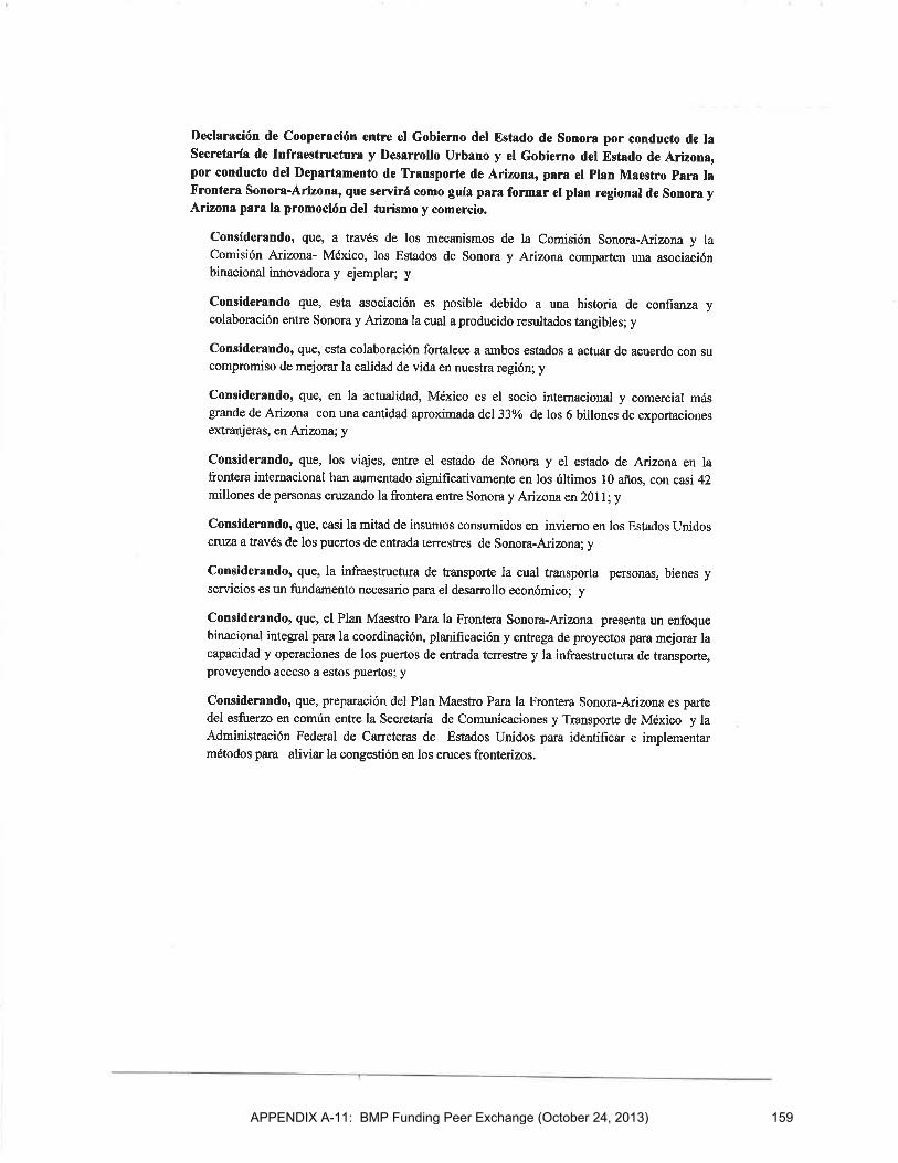
APPENDIX A-11: BMP Funding Peer Exchange (October 24, 2013) 159
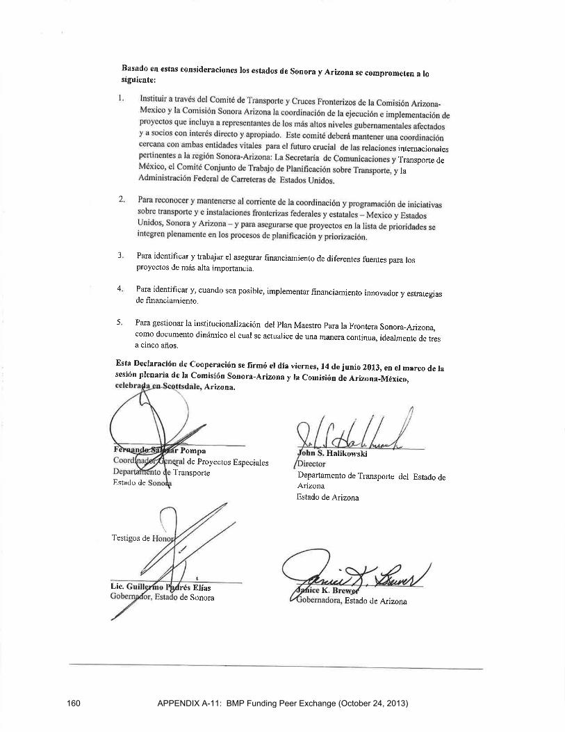
APPENDIX A-11: BMP Funding Peer Exchange (October 24, 2013)160
APPENDIX A-12: BMP Acknowledgements – Other than PAC and TWG
ACKNOWLEDGEMENTS
The California-Baja California 2014 Border Master Plan (BMP) Update was prepared with the assistance of many individuals from the BMP agencies.
(Current representatives of the Policy Advisory Committee (PAC) and Technical Working Group (TWG) are acknowledged separately in the BMP report. Individuals who contributed other than PAC and TWG
representatives are listed below.) U.S. Representatives (as of June 2014) (Agencies listed in alphabetical order) Arizona Department of Transportation (ADOT) Rudy Perez California Department of Transportation (Caltrans) Anthony Aguirre Trent Clark Oscar Cortes Maurice Eaton Yasnaia Florentino Marisa Hampton Beth Landrum Pat Landrum Jose I. Marquez-Chavez Kyle Nelson Mario Orso Alma Sanchez Rogelio Sanchez-Rangel Kathie Tirado Barby Valentine City of Calexico Alejandro Espinoza Nick Fenley City of Chula Vista Scott Tulloch City of Imperial Beach Gary Brown City of San Diego Nic Abboud Denice Garcia Nancy Gudino Mario C. Lopez
County of Imperial Bob Ham Customs and Border Protection (CBP) Mary Bowers Terri Caballero Lisa Dye Evelyn Evans Andrea Granados Paul Henning Deborah Jasperson Chris Maston Kenneth Morrison John Nigro Oscar Preciado Ellen Ramirez Brad Zerwas Department of State (DOS) Andrea Brouillette-Rodriguez Maximo Cervantes Sharyn Fitzgerald Giscard Guilloteau Steve Kashkett Peter Marigliano Susan Reinert Federal Highway Administration (FHWA) Manuel Sanchez Supin Yoder General Services Administration (GSA) Jon Ballard Abdee Gharavi New Mexico Department of Transportation (NMDOT) Homerio Bernal
161

ACKNOWLEDGEMENTS (CONT.)
APPENDIX A-12: BMP Acknowledgements – Other than PAC and TWG
San Diego Association of Governments (SANDAG) Christina Casgar Kim Kawada Jose Nuncio Elias Sanz Wu Sun Hector Vanegas Evan Wasserman SANDAG Service Bureau Elisa Arias Shane Babineaux Grace Chung Clint Daniels Koman Diabate Michael Garcia Tom Goggin Andy Gordon Jeffery Harns Andrea Hoff Karen Lamphere Cheryl Mason Alfredo Medina Joaquin Ortega Audomero Ruelas Sonya Smith Tim Sutherland Karyn Thompson Francesca Webb
Southern California Association of Governments (SCAG) Mike Ainsworth Naresh Amatya Margaret Lin Rich Macias Tomás Oliva Alan Thompson Texas Department of Transportation (TxDOT) Eduardo Hagert
162

ACKNOWLEDGEMENTS (CONT.)
APPENDIX A-12: BMP Acknowledgements – Other than PAC and TWG
Mexico Representatives (as of June 2014) (Agencies listed in alphabetical order)
Consulate General of Mexico in San Diego Alberto Díaz Elvira Felix Francisco Javier Olavarría General Customs Administration (Aduanas) Carlos Morales Tayavas General Customs Administration (Aduanas)-Tijuana Angélica Echegoyen Flores Elva C. Santibañez Luis Alfonso Torres Torres Institute of Administration and Estimates of National Real Estate (INDAABIN) Héctor Enrique De Dios Abascal Roberto Gámez Aguirre Luisa Fernanda Monica Herrera Martin Luis Enrique Mendez Ramirez Eliseo Rosales Avalos Guillermo Villagómez Alejandro Zúñiga Camacho Metropolitan Planning Institute of Tijuana (IMPlan) Fausto Armenta Alma Sevilla Municipal Planning Institute of Mexicali (IMIP) Inocencio Cuellar López Elias Paez Eduardo Raya Municipality of Mexicali Eduardo Contreras Alva Municipality of Playas de Rosarito César Villegas Campoy
Municipality of Tecate Gabriel Vázquez Murillo Office of the Governor of Baja California Mario Gerardo Herrera Zárate Mario Alberto Díaz Solís National Immigration Institute of Mexico (INM)
Aide Rosales Secretariat of Communications and Transportation (SCT)
Juan José Erazo García Cano Alberto Fernandez Obviedo Secretariat of Exterior Relations (SRE) Sean Carlos Cázares Gabriela Ruíz Secretariat of Infrastructure and Urban Development (SIDUE) Carlos Flores Vásquez Sergio Eduardo Montes Montoya Delia Moreno America Robles Blanca Leticia Rodriguez Ninfa Ornelas SRE - International Boundary and Water Commission Toribio Cueva State of Tamaulipas Vicente San Martin
Binational Representatives (as of June 2014) North American Development Bank (NADBANK)
Jose Miguel Tellechea
163

This page intentionally left blank
Comments and Responses on April 2014 Draft ReportCalifornia-Baja California 2014 BMP Update
APPENDIX A-13: Comments and Responses on Draft Report
No. Date Name/ Agency Ref. Comment Response
1 4/10/2014 Technical Working Group (TWG)
General Comment
Based on a suggestion by the Federal Highway Administration (FHWA), the TWG recommended that California Department of Transportation (Caltrans) and Secretariat of Infrastructure and Urban Development (SIDUE) include a letter signed by the directors of Caltrans District 11 and SIDUE, in the final BMP report to thank the BMP agencies for their participation and highlight the importance of the BMP effort.
A letter signed by the Director of Caltrans, District 11 and the Secretary of SIDUE will be included in the Final 2014 BMP Update report.
2 4/10/2014 FHWA General Comment
FHWA asked whether a risk-based approach is part of the BMP methodlogy to evaluate projects and programs.
BMP agencies identify projects for the BMP but not programs at this time.
3 4/10/2014 SIDUE Chapter 4 SIDUE will submit two rail projects that were omitted during the project submission phase. These projects will be added to the BMP Project Inventory List. They will be catalogued only and will not be ranked. The first project is a trolley line for passenger service in a segment between the cities of Tijuana and Tecate. The second project is a freight rail project connecting the Tijuana-Tecate railroad line to El Sauzal, in the Municipality of Ensenada. Both projects will initially be shown as dashed lines on the maps. With PAC concurrence, the dashed lines will be converted to solid lines for the final report. The technical data for these projects will be included in the Appendix and the projects will be listed in the report. These two projects are included in various planning documents in Mexico, which is a pre-requisite for submitting projects.
The trolley line for passenger service in a segment between the cities of Tijuana and Tecate will be shown on Figure 4.5, Transit Projects, in Chapter 4. The freight rail project connecting the Tijuana-Tecate railroad line to El Sauzal, in the Municipality of Ensenada will be shown on a new freight rail map in Chapter 4 for the Tecate-Tecate POE. Both projects are shown as dashed lines on the maps. With Policy Advisory Committee (PAC) concurrence, the dashed lines will be converted to solid lines for the final report. Both projects will be listed in the Project Inventory List.
165
Comments and Responses on April 2014 Draft ReportCalifornia-Baja California 2014 BMP Update
APPENDIX A-13: Comments and Responses on Draft Report
No. Date Name/ Agency Ref. Comment Response
4 4/10/2014 BMP Technical Working Group
General Comment
The TWG supported the proposal from Caltrans and SIDUE to invite the North American Development Bank (NADBANK) to the next BMP PAC meeting. Caltrans will invite a NADBANK representative.
Caltrans sent an email to NADBANK to invite a representative to attend the June 12, 2014 BMP PAC meeting.
5 4/10/2014 SIDUE General Comment
The TWG supported the proposal from SIDUE to invite the Secretariat of Agrarian, Territorial and Urban Development (SEDATU) to the next BMP PAC meeting. In addition, because the planning responsibilities have moved from the Secretariat of Social Development (SEDESOL) to SEDATU, SIDUE will request the PAC replace SEDESOL with SEDATU as a participating BMP agency for future BMP updates. This proposal will be discussed at the next PAC meeting.
SIDUE invited the Secretariat of Agrarian, Territorial and Urban Development (SEDATU) to attend the June 12, 2014 BMP PAC meeting. The proposal to replace SEDESOL with SEDATU as a participating BMP agency for future BMP updates will be discussed at the next PAC meeting.
6 4/10/2014 TWG General Comment
Based on a suggestion by the Metropolitan Planning Institute of Tijuana (IMPlan), the TWG requested that Caltrans and SIDUE explore the possibility of obtaining an acknowledgement from the California and Baja California state governments on the California-Baja California BMP effort.
Action item for Caltrans and SIDUE is noted.
7 4/10/2014 County of San Diego
Chapter 4, page 4-53
County of San Diego requested that the interchange at SR-125 and Lonestar be reassigned from the Otay Mesa – Mesa de Otay Port of Entry (POE) to the new proposed Otay Mesa East – Mesa de Otay II POE and be included on the map.
This project was reassigned from the Otay Mesa – Mesa de Otay Port of Entry (POE) to the new proposed Otay Mesa East – Mesa de Otay II POE. It was also added to the map in Figure 4.2 for Otay Mesa East – Mesa de Otay II in Chapter 4.
166
Comments and Responses on April 2014 Draft ReportCalifornia-Baja California 2014 BMP Update
APPENDIX A-13: Comments and Responses on Draft Report
No. Date Name/ Agency Ref. Comment Response
8 4/10/2014 Caltrans and SIDUE
General Comment
Caltrans and SIDUE will invite interested BMP agencies to participate in an ad hoc work group to develop a process to make the California-Baja California BMP a living document.
Action item for Caltrans and SIDUE is noted.
9 4/15/2014 City of Chula Vista
Figure 4.4 on page 4-33
My understanding is that SANDAG de-funded the 4 HOVs on I-805 as shown on quite a few of the figures. I think the next RTP will show 8+2HOV instead of the 8+4ML on I-805 but only between SR54 and SR905. Request to revisit the footnote we included in the draft report to make sure it is as clear as possible and pertains to the correct freeway segments. Also add appropriate footnote to the figures.
The footnotes in the tables in Chapter 4 and in appropropriate sections of the Appendix have been revised as follows: Project No. 1020009, I-805 + 4ML (SR 905 to Palomar St.): This segment will be revised from 8F + 4 ML to 8F + 2 HOV in the SANDAG 2050 RTP Update. Project No. 1020010, I-805 + 4ML (Palomar St. to SR 94): The segment between Palomar St. and SR 54 will be revised from 8F + 4 ML to 8F + 2 HOV in the SANDAG 2050 RTP Update. Similar footnotes were added to the map in Figure 4.4 in Chapter 4.
10 4/22/2014 SANDAG Chapter 5, Performance measure 8-11:
The SANDAG ABM cannot forecast POE wait times currently. The ability to forecast POE wait times by mode is dependent on federal agencies maintaining and further developing the BorderWizard model. The need for training and local calibration might also arise in order for MPO/Caltrans staff to adequately impute future wait times from BorderWizard into the SANDAG ABM. The future binational model for each metropolitan area intends to forecast POE wait times by mode.
Chapter 5 has been revised to add these clarifications.
167

Comments and Responses on April 2014 Draft ReportCalifornia-Baja California 2014 BMP Update
APPENDIX A-13: Comments and Responses on Draft Report
No. Date Name/ Agency Ref. Comment Response
11 4/22/2014 SANDAG Chapter 5, Performance measures 12-13
In light of SB743, it might be prudent to mention that LOS, in the future, may no longer be an acceptable performance measure for certain applications. I’m not sure an alternative to LOS is needed at this moment for this report.
The following text has been added to the definitions of performance measures 12 and 13: " This metric could be revisited as the model is developed to determine if it is still a valid measure given California State legislation SB743."
12 4/25/2014 CBP Executive Summary (ES)-37, Table ES.2, Goal 1.3
With regard to the following statement, “Subject to funding availability, comprehensive California- Baja California BMP updates would take place every four to six years. Caltrans and SIDUE would lead efforts to seek funding and manage these updates, in collaboration with the California- Baja California BMP Policy Advisory Committee, and, within the framework of the U.S.-Mexico Joint Working Committee (JWC).” CBP commented: How far in advance of the funding request is collaboration with the PAC and JWC expected to commence? Is this expected to be an ongoing process included within the proposed working group activities?
Yes. The PAC agreed to pursue the mechanisms to allow the BMP to become an ongoing binational process with sustainable funding sources. Caltrans and SIDUE will pursue this goal until otherwise advised by the PAC. Collaboration between SIDUE and Caltrans with the JWC will be ongoing. The PAC will meet annually until the next BMP update begins. As stated in BMP Recommendation 1.1 in Chapter 7, Caltrans and SIDUE will convene a working group to develop a process to make the BMP a living document. This ad hoc working group will meet separately from the annual PAC meetings.
13 4/25/2014 SCAG Chapter 5, Page 5-35
Suggest adding a sentence to make it clear that the cost estimate does not include data development/acquisition costs. Additional needed travel surveys and other data may represent a substantial cost (note – costs may be absorbed by the appropriate governmental agency, but data related costs should be acknowledged).
The following text was added to the section called Summary of Cost Estimates in Chapter 5: "It should be noted that cost estimates do not include data development and acquisition costs. Additional needed travel surveys and other data may represent a substantial additional cost to model development."
14 4/25/2014 SCAG Chapter 5, Page 5-41
"“SCAG is currently developing an ABM”. Please change to - “SCAG is currently developing an Activity Based Model, due for release in May 2016.”
The text in Chapter 5 has been updated to reflect this change.
168
Comments and Responses on April 2014 Draft ReportCalifornia-Baja California 2014 BMP Update
APPENDIX A-13: Comments and Responses on Draft Report
No. Date Name/ Agency Ref. Comment Response
15 4/25/2014 SCAG Chapter 5 General comment: Transportation models are generally calibrated to replicate user’s current travel behaviors. A border model’s future forecast is also driven by international policies. Therefore, the final border model needs to include sensitivities to various policy changes that might affect the model’s forecast.
While traditional transportation models are generally calibrated to replicate user’s current travel behavior, the future binational border model cannot be driven by international policies. However the future model should provide opportunities to model, via sensitivity analsyis, changes in national policies impacting future cross border movements of people and goods. The text in Chapter 5 has been updated to reflect this comment.
16 4/28/2014 SANDAG General Various suggestions related to wording and grammar were noted.
Various grammatical and style edits were made.
17 4/28/2014 SANDAG General Maps
The maps would better demonstrate delineations and jurisdictions if more color were used to demarcate areas
Maps have been revised to better demarcate delineations and other features.
18 4/30/2014 ICTC Chapter 4, Page 4-41, 1st paragraph, 3rd sentence
Can you revise the sentence to read, “ In the U.S., the corresponding projects are not planned to be open to traffic until 2020 and 2022, due to budget and funding shortfalls. The U.S. is hopeful for a Congressional appropriation in the FY 2014-2015 budget for Phase 1.” Can you also replace the last sentence of this paragraph to read: “The Imperial and Mexicali stakeholders continue to coordinate dates and interim solutions to facilitate the movement of pedestrians and passenger vehicle traffic.”
Chapter 4 text has been revised as follows: In the United States, the corresponding projects are not planned to be open to traffic until 2020 and 2022 due to budget and funding shortfalls. This could potentially be addressed through a Congressional appropriation in the FY 2014-2015 budget for Phase 1. In the meantime, an interim pedestrian processing facility in the U.S. is planned for completion in 2017, the same year the pedestrian facility in Mexico should be open. The Imperial and Mexicali stakeholders continue to coordinate dates and interim solutions to facilitate the movement of pedestrians and passenger vehicle traffic.
169
Comments and Responses on April 2014 Draft ReportCalifornia-Baja California 2014 BMP Update
APPENDIX A-13: Comments and Responses on Draft Report
No. Date Name/ Agency Ref. Comment Response
19 4/30/2014 ICTC Chapter 4, Page 4-63, 5th paragraph 5, 1st sentence:
This sentence begins with the term “Rail” projects, could you begin using the term “Transit” instead? For Imperial or Mexicali, I don’t believe either of us have any rail improvements proposed at the POEs.
Chapter 4 text has been revised to reflect this change and read Mass Transit.
20 4/30/2014 Caltrans ES Reduce Executive Summary to 5 or 6 pages. Since it will not be a stand alone Executive Summary it should be higher-level. Remove POE-specific maps.
Executive Summary has been revised; only the POE ranking maps have been included.
21 4/30/2014 Caltrans General Various suggestions related to wording, grammar, consistency, and style.
Various grammatical and style edits were made.
22 4/30/2014 Caltrans ES and Chapter 1
Include more information on the 2008 BMP to link the initial effort and the update. This will be helpful to readers who have not read the 2008 BMP
Background information was added to the Executive Summary and Chapter 1 to provide information on the initial 2008 effort.
23 4/30/2014 Caltrans Chapter 4 Caltrans suggested that the maps in Chapter 4 need more color to clearly show area of influence, focused study area, and to distinguish between existing, future and potential POEs. Also: 1) enlarge freeway shields so they are easier to read, 2) add legend to distinguish the transit projects on the maps, and 3) add dashed or shading to designate the focused study area on the maps.
The maps have been revised to reflect these changes.
24 4/30/2014 Caltrans Chapter 4 Include a reference so that the reader understands what the project numbers are on the maps.
The map legends have been revised to reference project numbers.
170

Appendix B: Survey of BMP Agencies


AGENDA ITEM 6 California-Baja California BMP Update KICK-OFF MEETING 11-29-11
401 B Street, Suite 800, San Diego, CA 92101-4231 Phone 619.699.1900 Fax 619.699.1905 Online www.sandag.org/servicebureau
APPENDIX B-1: Survey Response Summary
November 29, 2011
TO: California-Baja California Border Master Plan Update Policy Advisory Committee and Technical Working Group
FROM: SANDAG Service Bureau
SUBJECT: Task 1: Survey for California-Baja California 2011/12 Border Master Plan Update Task 1 of the California-Baja California 2011/12 Border Master Plan (BMP) Update Scope of Work has the objective of making this BMP to be of use for all participating agencies. Hence, Task 1 calls for 1) documenting how BMP agencies have used the 2008 BMP and 2) obtaining written input on the tasks in the preliminary Scope of Work for the 2011/12 BMP Update. This is an important task as the 2011/12 BMP Update requires input from, and collaboration with, many U.S. and Mexico local, regional, state, and federal stakeholders who will contribute to this effort. The first task in the project is devoted to obtaining their input regarding essential elements of the BMP Scope of Work. A final Scope of Work is being developed through a scoping process that has included informal meetings with nearly all of the BMP agencies to gauge their interest in participating in the BMP Update, review the preliminary Scope of Work, and obtain input to help develop the final Scope of Work. In addition to these informal meetings, a two-part questionnaire was distributed to the BMP agencies. The first part of the questionnaire focused on how agencies have used the 2008 BMP. The second part of the questionnaire focused on the areas of study agencies would like to include as part of the final Scope of Work for the 2011/12 BMP Update. The survey included both quantitative and qualitative questions. This memorandum summarizes the responses to the questionnaire, beginning with anoverview of key findings, followed by descriptions of how respondents answered each question. The purpose of this memorandum is to provide information to the BMP PAC to assist them in providing final direction and approval of the final Scope of Work for this Study. Overview of Findings The questionnaire was distributed to 31 agencies and 26 agencies responded. Nearly 70 percent of
respondents stated that they used the 2008 BMP in their planning activities in some way. Responses indicated that agencies valued the BMP as an important planning tool, policy guide, and reference document.
173
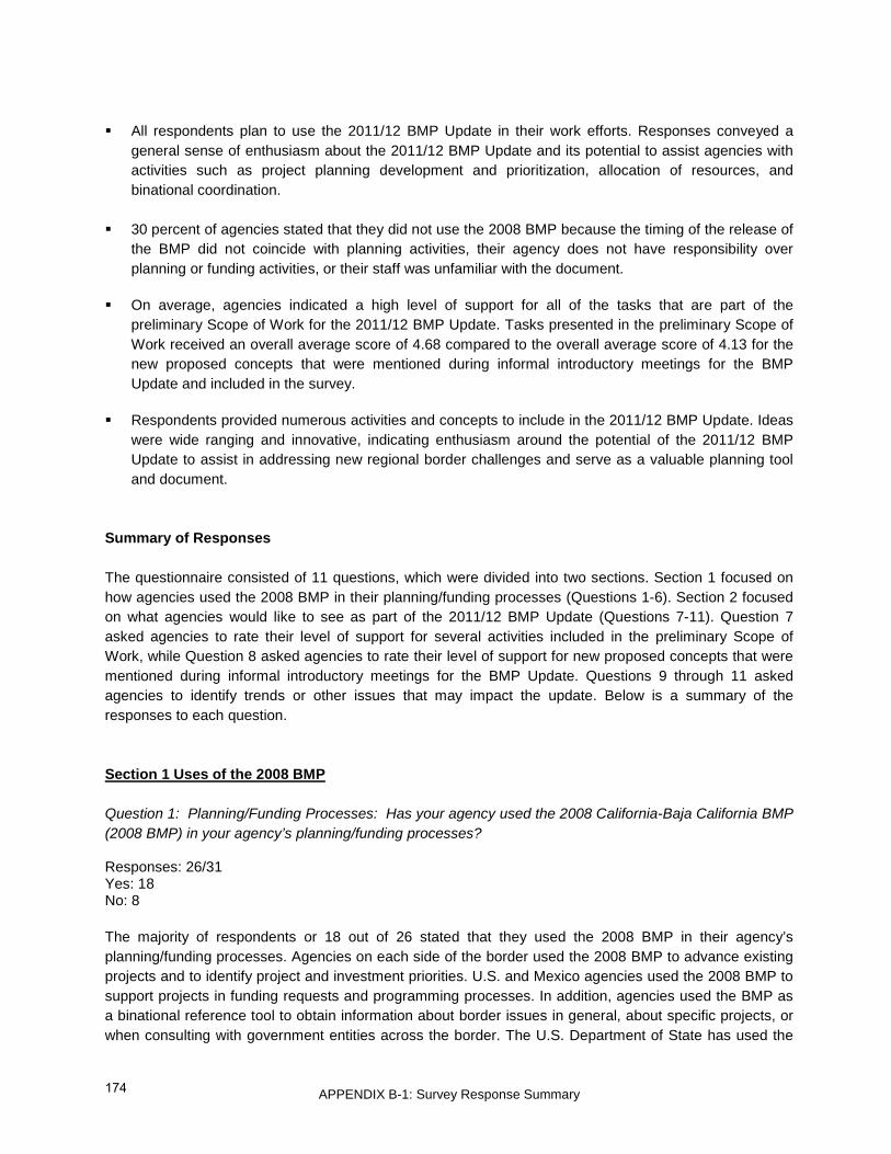
APPENDIX B-1: Survey Response Summary
All respondents plan to use the 2011/12 BMP Update in their work efforts. Responses conveyed a general sense of enthusiasm about the 2011/12 BMP Update and its potential to assist agencies with activities such as project planning development and prioritization, allocation of resources, and binational coordination.
30 percent of agencies stated that they did not use the 2008 BMP because the timing of the release of
the BMP did not coincide with planning activities, their agency does not have responsibility over planning or funding activities, or their staff was unfamiliar with the document.
On average, agencies indicated a high level of support for all of the tasks that are part of the
preliminary Scope of Work for the 2011/12 BMP Update. Tasks presented in the preliminary Scope of Work received an overall average score of 4.68 compared to the overall average score of 4.13 for the new proposed concepts that were mentioned during informal introductory meetings for the BMP Update and included in the survey.
Respondents provided numerous activities and concepts to include in the 2011/12 BMP Update. Ideas
were wide ranging and innovative, indicating enthusiasm around the potential of the 2011/12 BMP Update to assist in addressing new regional border challenges and serve as a valuable planning tool and document.
Summary of Responses The questionnaire consisted of 11 questions, which were divided into two sections. Section 1 focused on how agencies used the 2008 BMP in their planning/funding processes (Questions 1-6). Section 2 focused on what agencies would like to see as part of the 2011/12 BMP Update (Questions 7-11). Question 7 asked agencies to rate their level of support for several activities included in the preliminary Scope of Work, while Question 8 asked agencies to rate their level of support for new proposed concepts that were mentioned during informal introductory meetings for the BMP Update. Questions 9 through 11 asked agencies to identify trends or other issues that may impact the update. Below is a summary of the responses to each question. Section 1 Uses of the 2008 BMP Question 1: Planning/Funding Processes: Has your agency used the 2008 California-Baja California BMP (2008 BMP) in your agency’s planning/funding processes? Responses: 26/31 Yes: 18 No: 8 The majority of respondents or 18 out of 26 stated that they used the 2008 BMP in their agency’s planning/funding processes. Agencies on each side of the border used the 2008 BMP to advance existing projects and to identify project and investment priorities. U.S. and Mexico agencies used the 2008 BMP to support projects in funding requests and programming processes. In addition, agencies used the BMP as a binational reference tool to obtain information about border issues in general, about specific projects, or when consulting with government entities across the border. The U.S. Department of State has used the
174

APPENDIX B-1: Survey Response Summary
2008 BMP when reviewing Presidential Permit Applications and in federal policy meetings. Agencies in both countries have incorporated aspects of the BMP into their state, regional, and metropolitan plans. Several agencies did not use the BMP in their planning/funding processes because the timing of the release of the BMP did not coincide with planning activities. Other agencies noted that their agency does not have responsibility over planning or funding activities, while others mentioned staff being unfamiliar with the document. Question 2: Planning/Funding Documents: Has your agency included aspects of the 2008 California- Baja California BMP into your agency’s planning/funding-related documents? Responses: 26/31 Yes: 16 No: 10 The majority of agencies (62%) used the 2008 BMP in their planning/funding-related documents. Agencies have incorporated aspects of the 2008 BMP into their investment plans, state and local improvement plans, system planning documents, general plans, metropolitan plans, regional transportation plans, grant applications, and funding requests. Specific documents cited by agencies that used the 2008 BMP included the following:
• Metropolitan Strategic Plan for Tijuana-Tecate-Playas de Rosarito • Baja California State Development Plan • 2008-2012 Investment Strategy of the Secretariat of Communications and Transportation • County of Imperial General Plan • 2050 San Diego Regional Transportation Plan • Caltrans District 11 Goods Movement Business Plan • District 11 System Management Plan • San Diego and Imperial Counties Transportation Concept Corridor Reports • San Diego and Imperial Counties Transportation System Development Plan • Jacumba-Jacumé Programming documents
Question 3: Evaluation Criteria: Has your agency included any of the BMP evaluation criteria for prioritizing projects into your agency’s planning process? Responses: 25/31 Yes: 8 No: 17 Most agencies (68%) did not use evaluation criteria from the 2008 BMP in their planning processes. Reasons included that agency roles and activities do not include criteria ranking of projects, or there was a lack of staff familiarity with the BMP. Those that have used BMP evaluation criteria listed the following specific measures and aspects used: accident data, truck percent share, cost effectiveness, environmental benefits and impacts, economic benefits, throughput/capacity, travel demand, congestion, project performance, project readiness, regional benefit, average annual daily traffic, levels of service, and border wait times.
175

APPENDIX B-1: Survey Response Summary
Question 4: Funding Requests: Has your agency used the 2008 BMP to obtain funding for specific projects? Responses: 25/31 Yes: 10 No: 15 More than half or 15 out of 25 agencies did not use the 2008 BMP for funding requests. Those agencies cited reasons including timing of the BMP release, lack of staff familiarity with the plan, and lack of authority or responsibility for making funding requests. Ten agencies used the BMP to request funding for the following projects and project types:
• San Ysidro Port of Entry (POE) Phase I construction • San Ysidro Intermodal Transit Center Study • Imperial Avenue Interchange and Imperial Avenue extension to McCabe Road • Otay Mesa East POE and State Route 11 • Otay Mesa East POE Intelligent Transportation System Study • SR 905/805 Interchange • Calexico West POE and surrounding local roads and highways • Baja California POE projects and nearby roadways and land acquisition • Avenida México, Tecate • Concessions and Public Private Partnerships
Question 5: Please describe any other ways your agency has used the 2008 BMP. Responses: 15/31 Agencies at all levels of government used the 2008 BMP other ways not mentioned earlier in the responses to the questionnaire. Federal agencies on both sides of the border have promoted the 2008 BMP as a model for other border states to follow. Agencies have used the 2008 BMP to substantiate investment choices and make recommendations to policy makers. The BMP has been used as an education tool to inform policy makers about the border region and its planning. Several agencies have used data images, maps, and information contained in the plan for reports and presentations. Finally, the 2008 BMP served to stimulate dialogue about border issues andborder region planning and projects. Question 6: If your agency has not used the 2008 BMP, please describe why not. Responses: 9/31 Nine agencies provided reasons why they did not use the 2008 BMP in their planning/funding processes. Two stated that timing of the release of the 2008 BMP did not coincide with their funding request periods
176
APPENDIX B-1: Survey Response Summary
or planning activities. Four agencies stated that their staff was not fully aware of the BMP and three agencies stated that they do not have the authority or responsibility to implement or independently promote BMP projects. Section 2 Scope of Work for 2011/12 BMP Update Starting on Question 7, Section 2 of the questionnaire focused on what activities agencies would like to conduct as part of the 2011/12 BMP Update. First, agencies were asked to rate the importance of activities in the existing proposed Scope of Work using a Likert or rating scale of 1 to 5, with 5 being “strongly support” and 1 being “do not support at all”. Next, agencies were asked to rate the level of support for new proposed concepts for the 2011/12 BMP Update using the same Likert scale (Question 8). The new proposed concepts were suggested by BMP agencies during the information meetings. Questions 9 through 11 were open-ended and asked how agencies would like to see the 2011/12 BMP Update developed and used. Below is a summary of Section 2 of the questionnaire. Question 7: Existing Tasks in the Proposed Scope of Work Please indicate how important you feel it is to include the following tasks in the BMP Update by marking “X” in the appropriate box, where 5 is strongly support and 1 is do not support at all Respondents were asked to score tasks in the currently proposed preliminary Scope of Work. Attachment 1 shows the average scores respondents gave to each of the tasks in the proposed Scope of Work and lists them in order of support. Responses showed that agencies support all tasks in the preliminary Scope of Work. All tasks received an average score of 4 or above. Tasks were ranked as follows, from highest to lowest average score:
• Task 6 Conduct Data Gap Analysis for BMP POE Sensitivity Analysis • Task 7 Identifying Funding Issues and Opportunities • Task 5 Inventory and Evaluate BMP Data, Sources, and Capabilities • Task 4 Update Project Lists • Task 8 Draft Recommendations.
Question 8: New Proposed Concepts for the BMP Update Please indicate how important you feel it is to include the following tasks in the BMP Update by marking “X” in the appropriate box, where 5 is strongly support and 1 is do not support at all Agencies were asked to score new proposed concepts for the 2011/12 BMP Update mentioned during the informal preparatory meetings. Attachment 2 shows the average scores respondents gave to each of the 15 new proposed concepts in order of support. All 15 of the proposed concepts received score of 3 and above, indicating a high level of support for most new proposed concepts. The three highest scoring concepts were:
• Include a discussion of north-bound and south-bound short term operational improvements at the border to reduce wait times (e.g., FAST and express lanes). (average score of 4.62)
177

APPENDIX B-1: Survey Response Summary
• Include infrastructure projects for non-motorized modes of cross border travel. (average score of 4.46)
• Include a discussion of north-bound and south-bound short term capital investments at the border to reduce wait times (e.g., use of ready lanes, tandem booths, and strategies focused on pedestrians).( average score of 4.42)
Agencies gave four of the new proposed concepts an average score of less than 4. Those concepts with the lowest scores are (listed from highest to lowest average score)
• re-ranking transportation projects based on updated information (3.92) • review and revise evaluation criteria for roadway, interchange, and rail projects (3.92) • establish a new base year and planning horizon year (3.50) • consider the potential of creating an entity to serve as a border clearing house for border related
issues and/or as a tolling authority and develop a possible framework for an expenditure plan. (3.48)
Although there was some variation among scores, it is notable that no concept received an average score lower than 3, which indicates that agencies on average support all of the new proposed concepts. Question 9: How would your agency most likely use the 2011/12 BMP Update? Responses: 25/31 More agencies plan to use the 2011/12 BMP Update than those that used the 2008 BMP. The 2011/12 BMP Update may be used by the U.S. Department of State as a reference tool given substantial weight during consideration of Presidential Permit Applications. Federal government agencies in the U.S and Mexico anticipate using the 2011/12 BMP Update to identify capital investment priorities and allocate resources, and as a planning tool for binational coordination of border projects. State and regional agencies plan to incorporate the findings of the BMP into their long-range transportation plans and systems planning documents. Local government agencies on both sides of the border expect to use the BMP Update as a reference tool or data source and to seek funding opportunities and promote specific projects. In Mexico, the Consulate General plans to use the information to further discuss and evaluate POE and border infrastructure projects at the binational U.S.-Mexico Border Liaison Mechanism meetings and SEDESOL anticipates using the update toidentify infrastructure projects for non-motorized modes and integrating alternative modes of transportation into local urban planning processes.
Question 10: Please share specific ideas your agency would like to see incorporated as part of the BMP Update. Responses: 21/31 Agencies provided significant and varied ideas for the 2011/12 BMP Update. Several ideas were echoed in earlier part of the questionnaire. Additional ideas not mentioned previously included:
• List and prioritize low cost, high impact projects to improve the POEs • Promote small projects by showing their interrelationship with surrounding transit and roadway
improvement projects
178

APPENDIX B-1: Survey Response Summary
• Capture the latest socio-economic developments in the region in order to ensure the continued legitimacy of the BMP as an objective, defensible mechanism for project prioritization
• Clearly identify the causes and effects of proposed border expansion projects on existing and proposed facilities, as well as the benefits of past projects
• Focus on innovative financing of border infrastructure projects • Integrate the BMP with the California Interregional Blueprint (formally known as California
Transportation Plan”) • Focus on alternative modes of transportation, including public transit, pedestrian, bike, rail, and
commuter ferry or other water transportation • Study Intelligent Transportation System (ITS) strategies to increase efficiency at the border • Include new sections in the document containing:
o formal approvals of participating agencies o information about interagency/government coordination needed for project implementation o role and function of the BMP with regard to local planning, infrastructure activities, and
funding/grant requests • Consider developing POEs at Border State Park and Jacumba-Jacumé • Promote tourism of sites and facilities in nearby communities through way finding or other traveler
information at the POEs • Develop a systematic approach to POE planning and design • Incorporate intermodal system integration and Traffic Management Centers into border ITS
Question 11: Please describe any new issues and/or trends your agency would like to be considered in this BMP Update… Responses: 18 Agencies provided numerous ideas about new issues and trends that they felt could be considered as part of the 2011/12 BMP Update. Issues and trends identified include the following (not in priority order):
• Infrastructure implications of southbound inspections at POE facilities • Resource limitations at U.S. federal level • Certification of Mexican trucks in U.S. by Federal Motor Carrier Safety Administration • New mandates and interest regarding Green House Gas emissions reduction, Complete
Streets,Smart Growth, and sustainability • New finance and delivery mechanisms for border infrastructure projects • The proposed San Diego-Tijuana Airport Cross Border Facility and its potential impacts on cross
border traffic; need to provide access to the facility • Increased travel southbound for employment • Analysis of ‘fenced’ borders between the U.S. and Mexico • Focus on alternative modes of travel and truly multi-national projects such as trails and bike paths • Case studies of best practices from other urban and rural POEs • Analysis of operational improvements and POE expansion projects • Coordinationof plans between POE projects and local city projects • Security issues at POEs • Value of cross border commerce to the region and implications for infrastructure investments (e.g.
regional investment in SR 125)
179

APPENDIX B-1: Survey Response Summary
• Coordinated analysis of environmental mitigation and land use in areas around POEs • Analysis of project funding schedules and phased implementation plans • Possible increased access to Border State Park • Analysis of San Ysidro expansion project, including potential impacts of implementation schedule
of Phases 2 and 3 on wait times and consideration of proposed connection routes to El Chaparral gate in Mexico
• Proposed Jacumba-JacuméPOE • Examination of cross border freight rail • Innovative and dynamic tolling systems • Integrated operational systems within POE inspection processes and examination of guaranteed
crossing times • Use of technologies to enhance and expedite crossing times on both sides of the border • Exploration of cooperative agreements among states to commit to funding future updates of the
BMP
Conclusion and Next Steps
In general, agencies that responded to the questionnaire indicated their use and support for the 2008 BMP and support for the 2011/12 BMP Update. Agencies have and plan to continue to use the BMP in their border region planning, funding, policy making, and project development processes. This Technical Memorandum summarizes results from the survey. Under a separate cover, individual agency responses are documented and compiled. The survey results were used to develop three possible scenarios for the 2011/12 BMP Update scope of work. These three scenarios are summarized in the separate Technical Memorandum “Task 2: Scenarios for Scope of Work for the 2011/12 California-Baja California Border Master Plan (BMP) Update” as part of the agenda for the California-Baja California 2011/12 BMP November 29, 2011 meeting.
180

APPENDIX B-1: Survey Response Summary
ATTACHMENT 1 Question 7: Existing Tasks in the Proposed Scope of Work Summary of Average Scores
Task (In Order of Support)
No. of Agencies that Answered Question
Average Score
Task 6: Conduct Data Gap Analysis for BMP POE Sensitivity Analysis: Identify the level of analysis, data, tools, and funding needed to move toward the development of modeling capabilities that could help assess the impact and sensitivity of different POE and transportation infrastructure investments within a POE system in a metropolitan area. 26 4.81 Task 7: Identify Funding Issues and Opportunities: Identify possible funding opportunities and sources including legislation or regulations needed for the California-Baja California BMP to become a permanent, long-range and ongoing binational process. 26 4.73 Task 5: Inventory and Evaluate BMP Data, Sources, and Capabilities: Review, evaluate, and query data sources currently available and inventory existing data and capacities of current transportation models for California-BajaCalifornia.
26 4.69 Task 4: Update Project Lists: Update data on existing POE and related transportation improvement projects using a web-based data entry system to provide an opportunity for BMP agencies to incorporate information on new planned projects, transmit changes to projects already submitted, and report on completed projects. 26 4.65 Task 8: Draft Recommendations: Prepare recommendations for next steps in the BMP process. 26 4.50 OVERALL 26 4.68 5 = Strongly Support 1 = Do Not Support at All
181

APPENDIX B-1: Survey Response Summary
ATTACHMENT 2 Question 8: New Proposed Concepts for the BMP Update Summary of Average Scores
Proposed Concept (In Order of Support)
No. of Agencies that Answered Question
Average Score
Include a discussion of north-bound and south-bound short term operational improvements at the border to reduce wait times (e.g., FAST and express lanes). 26 4.62 Include infrastructure projects for non-motorized modes of cross border travel. 26 4.46
Include a discussion of north-bound and south-bound short term capital investments at the border to reduce wait times (e.g., use of ready lanes, tandem booths, and strategies focused on pedestrians). 26 4.42 Update existing and forecasted travel demand data for use in POE evaluation criteria for scoring the POE projects. 26 4.38 Discuss current status of short-term projects. 26 4.35 Update existing cross border wait times for use in POE evaluation criteria for scoring the POE projects. 26 4.31 Develop efficiency performance indicators to measure border wait times over time. 26 4.31 Discuss potential of creating a web portal to provide updated information on cross border projects and efforts. 26 4.15
Prepare specific recommendations and action items for appropriate agencies regarding implementing the findings as part of the next steps in the BMP process. 25 4.12 Re-rank the POE projects based on updated information. 26 4.04 Review and revise existing evaluation criteria for POE projects. 26 4.04 Re-rank the transportation projects based on updated information. 26 3.92 Review and revise existing evaluation criteria for roadway, interchange, and rail projects. 26 3.92 Establish new base year and planning horizon year (currently 2005-2030). 26 3.50
Consider potential of creating an entity to serve as a border clearing house for border related issues and/or as tolling authority and develop a possible framework for an expenditure plan. 25 3.48 OVERALL 26 4.13 5 = Strongly Support 1 = Do Not Support at All
182

APPENDIX B-2: Survey Results Packet
CALIFORNIA-BAJA CALIFORNIA BORDER MASTER PLAN UPDATE
Task 1
Survey of Border Master Plan Agencies Detailed Survey Results Packet
Contents:
• Survey Questionnaire
• Responses to Quantitative Portion (Question 7)
• Responses to Quantitative Portion (Question 8)
• Responses to Qualitative Portion (Questions 1-6; 9-11)
183

APPENDIX B-2: Survey Results Packet
184

APPENDIX B-2: Survey Results Packet
Survey Questionnaire
185

APPENDIX B-2: Survey Results Packet
186
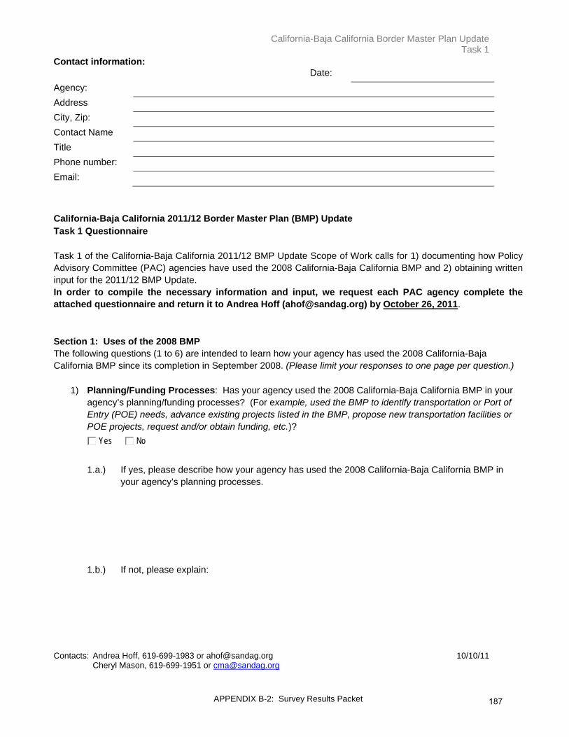
California-Baja California Border Master Plan Update Task 1
APPENDIX B-2: Survey Results Packet
Contact information: Date: Agency: Address City, Zip: Contact Name Title Phone number: Email:
California-Baja California 2011/12 Border Master Plan (BMP) Update Task 1 Questionnaire Task 1 of the California-Baja California 2011/12 BMP Update Scope of Work calls for 1) documenting how Policy Advisory Committee (PAC) agencies have used the 2008 California-Baja California BMP and 2) obtaining written input for the 2011/12 BMP Update. In order to compile the necessary information and input, we request each PAC agency complete the attached questionnaire and return it to Andrea Hoff ([email protected]) by October 26, 2011. Section 1: Uses of the 2008 BMP The following questions (1 to 6) are intended to learn how your agency has used the 2008 California-Baja California BMP since its completion in September 2008. (Please limit your responses to one page per question.)
1) Planning/Funding Processes: Has your agency used the 2008 California-Baja California BMP in your agency’s planning/funding processes? (For example, used the BMP to identify transportation or Port of Entry (POE) needs, advance existing projects listed in the BMP, propose new transportation facilities or POE projects, request and/or obtain funding, etc.)?
Yes No
1.a.) If yes, please describe how your agency has used the 2008 California-Baja California BMP in
your agency’s planning processes. 1.b.) If not, please explain:
Contacts: Andrea Hoff, 619-699-1983 or [email protected] 10/10/11 Cheryl Mason, 619-699-1951 or [email protected]
187

California-Baja California Border Master Plan Update Task 1
APPENDIX B-2: Survey Results Packet
2) Planning/Funding Documents: Has your agency included aspects of the 2008 California- Baja California BMP into your agency’s planning/funding-related documents1?
Yes No
2.a.) If yes, please describe: 2.b.) If not, please explain:
3) Evaluation Criteria: Has your agency included any of the BMP evaluation criteria for prioritizing projects into your agency’s planning process?
Yes No
3.a.) If yes, please describe: 3.b) If not, please explain:
4) Funding Requests: Has your agency used the 2008 BMP to obtain funding for specific projects? Yes No
4.a) If yes, please describe: 4.b.) If not, please explain:
5) Please describe any other ways your agency has used the 2008 BMP.
6) If your agency has not used the 2008 BMP, please describe why not.
1 Examples of Planning Documents: City/County General Plan Circulation Elements, City/County Community Plan Transportation Elements, Municipal Development Plans, Municipal Partial Programs, Regional Transportation Plans, State or National Development Plans, State Transportation Plans, Capital Improvement Plans (local, state, federal), Transportation Sector Programs, Border Crossing or Border Station Plans.
188

California-Baja California Border Master Plan Update Task 1
APPENDIX B-2: Survey Results Packet
Section 2: Scope of Work 2.A.) Existing Tasks in the Proposed Scope of Work The following questions pertain to the Proposed Scope of Work for the 2011/12 BMP Update. The Scope of Work is attached to this questionnaire for your reference.
7) Please indicate how important you feel it is to include the following tasks in the BMP Update by marking “X” in the appropriate box, where 5 is strongly support and 1 is do not support at all.
Strongly Support
Do Not Support
at All 5 4 3 2 1 Task 4: Update Project Lists Update data on existing POE and related transportation improvement projects using a web-based data entry system to provide an opportunity for BMP agencies to incorporate information on new planned projects, transmit changes to projects already submitted, and report on completed projects
Task 5: Inventory and Evaluate BMP Data, Sources, and Capabilities Review, evaluate, and query data sources currently available and inventory existing data and capacities of current transportation models for California-Baja California.
Task 6: Conduct Data Gap Analysis for BMP POE Sensitivity Analysis Identify the level of analysis, data, tools, and funding needed to move toward the development of modeling capabilities that could help assess the impact and sensitivity of different POE and transportation infrastructure investments within a POE system in a metropolitan area.
Task 7: Identify Funding Issues and Opportunities Identify possible funding opportunities and sources including legislation or regulations needed for the California-Baja California BMP to become a permanent, long-range and ongoing binational process.
Task 8: Draft Recommendations Prepare recommendations for next steps in the BMP process
189

California-Baja California Border Master Plan Update Task 1
APPENDIX B-2: Survey Results Packet
2.B.) New Proposed Concepts for the BMP Update During the informal meetings with PAC agencies, several ideas were suggested for inclusion in the 2011/12 BMP Update. These ideas are not currently part of the scope of work and, with the purpose of sharing and assessing the importance of these ideas, they are presented below.
8) Please indicate how important you feel it is to include the following tasks in the BMP Update by marking
“X” in the appropriate box, where 5 is strongly support and 1 is do not support at all.
Strongly Support
Do Not Support
at All 5 4 3 2 1 Consider potential of creating an entity to serve as a border clearing house for border related issues and/or as tolling authority and develop a possible framework for an expenditure plan
Discuss potential of creating a web portal to provide updated information on cross border projects and efforts
Re-rank the POE projects based on updated information Re-rank the transportation projects based on updated information Review and revise existing evaluation criteria for POE projects Review and revise existing evaluation criteria for roadway, interchange, and rail projects
Update existing and forecasted travel demand data for use in POE evaluation criteria for scoring the POE projects
Update existing cross border wait times for use in POE evaluation criteria for scoring the POE projects
Establish new base year and planning horizon year (currently 2005-2030) Please write in proposed planning horizon below:
Include a discussion of north-bound and south-bound short term capital investments at the border to reduce wait times (e.g., use of ready lanes, tandem booths, and strategies focused on pedestrians)
Include a discussion of north-bound and south-bound short term operational improvements at the border to reduce wait times (e.g., FAST and express lanes)
Develop efficiency performance indicators to measure border wait times over time
Discuss current status of short-term projects Include infrastructure projects for non-motorized modes of cross border travel
Prepare specific recommendations and action items for appropriate agencies regarding implementing the findings as part of the next steps in the BMP process
190

California-Baja California Border Master Plan Update Task 1
APPENDIX B-2: Survey Results Packet
9) How would your agency most likely use the 2011/12 BMP Update?
10) Please share specific ideas your agency would like to see incorporated as part of the BMP Update. (Please limit to one page and include uses for your ideas and types of related information/data your agency could provide.)
11) Please describe any new issues and/or trends your agency would like to be considered in this BMP Update. Please let us know how you think these issues may impact this BMP Update. Some examples include new policy and economic issues, legislation, and infrastructure completed and planned since the 2008 BMP. THANK YOU FOR YOUR SUPPORT AND FOR SENDING THE COMPLETED
QUESTIONNAIRE NO LATER THAN OCTOBER 26, 2011.
191
Actualización del Plan Maestro Fronterizo California-Baja California Tarea 1
APPENDIX B-2: Survey Results Packet
Datos de Contacto: Fecha:
Organismo: Domicilio Ciudad, C.P.: Nombre del Contacto:
Puesto: Teléfono: Correo-e:
Actualización del Plan Maestro Fronterizo (BMP) California-Baja California 2011/12 Cuestionario para la Tarea 1 La Tarea 1 de la Actualización del Alcance de Trabajo del BMP California-Baja California 2011/12, busca a) documentar la manera en que las dependencias que constituyen el Comité Asesor de Reglamentos/Políticas (PAC, por sus siglas en inglés) han utilizado el BMP California-Baja California 2008, y b) obtener sus comentarios por escrito respecto de la Actualización del BMP 2011/12. Para fines de recopilar los datos y comentarios necesarios, solicitamos a cada dependencia integrante del PAC ser tan gentil de llenar el cuestionario adjunto y enviarlo a Andrea Hoff ([email protected]) a más tardar el 26 de octubre de 2011. Sección 1: Usos del BMP 2008 Las siguientes preguntas tienen la finalidad de conocer la manera en que la dependencia que Usted representa ha utilizado el BMP California-Baja California 2008 desde que se finalizó en septiembre de 2008 (favor de limitar sus respuestas a una página por pregunta.)
1) Procesos relacionados con la Planeación y Financiamiento: ¿Ha utilizado la dependencia que Usted representa el BMP California-Baja California 2008 en sus procesos de planificación o financiamiento? (por ejemplo, haber utilizado el BMP para identificar necesidades de transporte o de alguna garita, avanzar en proyectos existentes incluidos en el BMP, proponer nuevas instalaciones de transporte o proyectos de garitas, etc.)
Si No
1.a) Si respondió que sí, por favor describa la manera en que su dependencia utilizó el BMP
California-Baja California en sus procesos de planificación y financiamiento. 1.b) En caso contrario, favor de explicar:
Contactos: Andrea Hoff, 619-699-1983 ó [email protected] 10/11/11
192

Actualización del Plan Maestro Fronterizo California-Baja California Tarea 1
APPENDIX B-2: Survey Results Packet
Cheryl Mason, 619-699-1951 ó [email protected]
2) Documentos de Planificación y Financiamiento: ¿Ha incluido su dependencia aspectos del BMP California-Baja California 2008 en los documentos de planificación o financiamiento de su dependencia1?
Si No 2.a) Si respondió afirmativamente, favor de describir: 2.b) De lo contrario, favor de explicar:
3) Criterios de evaluación: ¿Ha incluido su dependencia alguno de los criterios de evaluación del BMP para priorización de proyectos en el proceso de planificación de su dependencia?
Si No 3.a.) De ser así, favor de describir: 3.b.) En caso contrario, favor de explicar:
4) Solicitudes de financiamiento: ¿Ha utilizado su dependencia el BMP 2008 para obtener fondos para proyectos específicos?
Si No 4.a) De ser así, favor de describir: 4.b) En caso contrario, favor de explicar:
5) Por favor describa otras maneras en que su dependencia ha utilizado el BMP 2008.
6) En el caso de que su dependencia no haya hecho uso del BMP 2008, favor de describir el motivo de no haberlo hecho.
1 Ejemplos de documentos de planificación: Elementos de Circulación del Plan General del Municipio o Condado; Elementos de transporte de Planes Comunitarios del municipio o del condado; Programas Parciales Municipales; Planes Regionales de Transporte; Planes de Desarrollo regionales o nacionales; Planes Estatales de Transporte; Planes de Mejoras de Infraestructura (municipales, estatales, federales); Programas Sectoriales de Transporte; Planes de Garitas o Cruces fronterizos.
193

Actualización del Plan Maestro Fronterizo California-Baja California Tarea 1
APPENDIX B-2: Survey Results Packet
Sección 2: Alcance de Trabajo 2.A) Retroalimentación sobre las Tareas que incluidas en el Alcance de Trabajo propuesto Las siguientes preguntas son en referencia al Alcance de Trabajo propuesto para la Actualización del BMP California-Baja California 2011/12. Se anexa el Alcance de Trabajo al presente cuestionario para su referencia.
7) Favor de indicar qué tan importante considera que se incluyan las siguientes tareas en la actualización del BMP marcando con una “X” el recuadro correspondiente, donde el 5 representa que apoya fuertemente que se incluya y el 1 que no lo apoya en absoluto.
Lo
apoyo fuerte-mente
No lo apoyo
en absoluto
5 4 3 2 1 Tarea 4: Actualizar listados del proyecto Actualizar datos respecto de proyectos existentes de cruces fronterizos y proyectos de mejora de transporte usando un sistema de captura de datos en línea (por Internet) con el fin de brindar a las dependencias que forman parte del BMP la oportunidad de incorporar información respecto de nuevos proyectos que se tienen planeados, hacer cambios en proyectos que se ya habían registrado e informar acerca de proyectos terminados.
Tarea 5: Inventario y evaluación de datos, fuentes y capacidades del BMP Revisión, evaluación e investigación de fuentes de datos disponibles actualmente y realizar un inventario de datos existentes y capacidades de los modelos de transporte actuales para California-Baja California.
Tarea 6: Realizar análisis de brechas de información para el Análisis de Sensibilidad del BMP y las Garitas Identificar el nivel de análisis, los datos, las herramientas y el financiamiento necesarios para avanzar en el desarrollo de un modelo que coadyuve en la evaluación del impacto y sensibilidad de inversiones en cruces fronterizos e infraestructura de transporte dentro de un sistema de Garitas en un área metropolitana.
Tarea 7: Identificar retos y oportunidades de financiamiento Identificar posibles fuentes y oportunidades de financiamiento, entre ello legislación o normatividad necesaria para que el BMP se convierta en un proceso binacional permanente y continuo de largo plazo.
Tarea 8: Redacción de recomendaciones Preparar recomendaciones sobre los siguientes pasos en el proceso del BMP.
194
Actualización del Plan Maestro Fronterizo California-Baja California Tarea 1
APPENDIX B-2: Survey Results Packet
2.B) Propuesta de nuevos conceptos para la Actualización del BMP Durante las reuniones informales con las dependencias que constituyen el PAC, se sugirieron varias ideas para su inclusión en la Actualización 2011/12 del BMP. Actualmente, esas ideas no están incluidas en el alcance de trabajo original. Con el propósito de compartir y poderar esas ideas, éstas se presentan en el listado abajo.
8) Favor de indicar qué tan importante considera que se incluyan las siguientes tareas en la actualización del BMP marcando con una “X” el recuadro correspondiente, donde el 5 representa que apoya fuertemente que se incluya y el 1 que no lo apoya en absoluto.
Lo
apoyo fuerte-mente
No lo apoyo
en absoluto
5 4 3 2 1 Comentar las posibilidades para la creación de un organismo que funja como un observatorio fronterizo y/o autoridad para cobro de peaje, para el desarrollo de posibles esquemas de cooperación en asuntos relacionados con la frontera, incluyendo planes de gastos.
Comentar el potencial de crear un portal en línea con el fin de brindar información actualizada respecto de proyectos y esfuerzos transfronterizos
Volver a ponderar los proyectos de garritas en función de información actualizada
Volver a ponderar los proyectos de vialidades, conectores viales y ferroviarios en función de información actualizada
Revisar y actualizar los criterios de evaluación vigentes para proyectos de cruces fronterizos
Revisar y actualizar los criterios de evaluación vigentes para proyectos de vialidades, conectores viales y ferroviarios.
Actualizar datos sobre la demanda de traslados y tiempos de espera en garitas actual y pronosticada, para su uso en criterios de evaluación de proyectos de garitas con el fin de calificar dichos proyectos.
Actualizar datos sobre los tiempos de espera en garitas actual y pronosticada, para su uso en criterios de evaluación de proyectos de garitas con el fin de calificar dichos proyectos.
Establecer un nuevo año base y un nuevo horizonte de planeación (actualmente es 2005-2030). Por favor escriba su horizonte propuesto:
Incluir diálogo sobre los inversiones capitales en proyectos de corto o mediano plazo para reducir esperas en ambos lados de la frontera (p. ej., aumentar el uso de carriles “ready-lane”, doble caseta, estrategias centradas a peatones)
Incluir diálogo sobre los mejoramientos en operaciones a corto o mediano plazo para reducir esperas en ambos lados de la frontera (p. ej., aumentar el uso de FAST, carriles exprés)
195

Actualización del Plan Maestro Fronterizo California-Baja California Tarea 1
APPENDIX B-2: Survey Results Packet
Lo apoyo fuerte-mente
No lo apoyo
en absoluto
5 4 3 2 1 Desarrollar indicadores de desempeño de eficiencia para medir los tiempos de cruce a lo largo del tiempo.
Discutir el estado actual de proyectos a corto plazo Inclusión de proyectos de infraestructura para modalidades no motorizadas de traslado transfronterizo
Preparar recomendaciones específicas y puntos de acción para las agencias encargadas de la implementación de resultantes, y su consideración en el desarrollo de los siguientes pasos en el proceso del BMP
9) ¿De qué manera le gustaría a su agencia hacer uso de la Actualización del BMP 2011/12?
10) Por favor comparta las ideas que a su dependencia le gustaría ver incorporadas como parte de la Actualización del BMP. (Por favor limítese a una página e incluya formas de cómo se usarían sus ideas y los tipos de información y datos relacionados que su agencia podría ofrecer.)
11) Por favor describa cualquier asunto nuevo o tendencia que su agencia quisiera fuera considerado en esta actualización del BMP. Por favor déjenos saber cómo piensa que esos asuntos puedan impactar la actualización del BMP. Algunos ejemplos, sin que sean limitantes, pueden ser asuntos de política o económicos, legislación e infraestructura que ha sido terminada y planeada desde el BMP 2008.
¡GRACIAS POR SU APOYO Y POR ENVIAR EL CUESTIONARIO CONTESTADO NO DESPUÉS DEL 26 DE OCTUBRE DE 2011!
196

Responses to Quantitative Portion
(Question 7)
APPENDIX B-2: Survey Results Packet197

[This page was left intentionally blank]
APPENDIX B-2: Survey Results Packet198
2011/12, California-Baja California Border Master Plan (BMP) UpdateSummary of Responses to Quantitative Portion (Question 7)Survey Section 2A: Existing Tasks in the Proposed Scope of Work
Task (Ranked from High to Low Score)No. of Agencies that Answered Question
Average Score
Importance Rank
Task 6: Conduct Data Gap Analysis for BMP POE Sensitivity Analysis: Identify the level of analysis, data, tools, and funding needed to move toward the development of modeling capabilities that could help assess the impact and sensitivity of different POE and transportation infrastructure investments within a POE system in a metropolitan area.
26 4.81 1Task 7: Identify Funding Issues and Opportunities: Identify possible funding opportunities and sources including legislation or regulations needed for the California-Baja California BMP to become a permanent, long-range and ongoing binational process.
26 4.73 2Task 5: Inventory and Evaluate BMP Data, Sources, and Capabilities: Review, evaluate, and query data sources currently available and inventory existing data and capacities of current transportation models for California-Baja California.
26 4.69 3Task 4: Update Project Lists: Update data on existing POE and related transportation improvement projects using a web-based data entry system to provide an opportunity for BMP agencies to incorporate information on new planned projects, transmit changes to projects already submitted, and report on completed projects.
26 4.65 4Task 8: Draft Recommendations: Prepare recommendations for next steps in the BMP process. 26 4.50 5OVERALL 26 4.685 = Strongly Support1 = Do Not Support at All
APPENDIX B-2: Survey Results Packet199
Section 22.A.) Existing Tasks in the Proposed Scope of Work
7) Please indicate how important you feel it is to include the following tasks in the BMP Update by marking “X” in the appropriate box, where 5 is strongly support and 1 is do not support at all (Note SANDAG input into spreadsheet and statistical computation included actual answer by Agency).
Name of Agency ScoreAverage Score
U.S. Department of State (DOS) 5Customs and Border Protection (CBP) 5General Services Administration (GSA) 4FHWA Office of Planning 5California Department of Transportation (Caltrans) 5Imperial County Transportation Commission (ICTC) 4San Diego Association of Governments (SANDAG) 5Southern California Association of Governments (SCAG) 5County of Imperial 5City of Calexico 5City of El Centro 4City of Holtville 5County of San Diego 5City of Chula Vista 4City of Imperial Beach 5City of National City 5City of San Diego 4Secretariat of Exterior Relations (SRE)Consulate General of Mexico in San Diego 5Secretariat of Communications and Transportation (SCT) 5General Customs Administration (Administración General de Aduanas) México D.F. 5General Customs Administration (Administración General de Aduanas) Tijuana B.C.Secretariat of Social Development (SEDESOL) 5Institute of Administration and Estimates of National Real Estate (INDAABIN)Office of the Governor of Baja California 5Secretariat of Infrastructure and Urban Development (SIDUE) 5Municipal Planning Institute of Tijuana (IMPLAN) 5Municipality of Mexicali 5Municipality of RosaritoMunicipality of Tecate 5Municipality of TijuanaTotal 26 4.815 = Strongly Support1 = Do Not Support at All
Task 6: Conduct Data Gap Analysis for BMP POE Sensitivity Analysis: Identify the level of analysis, data, tools, and funding needed to move toward the development of modeling capabilities that could help assess the impact and sensitivity of different POE and transportation infrastructure investments within a POE system in a metropolitan area.
APPENDIX B-2: Survey Results Packet200
Section 22.A.) Existing Tasks in the Proposed Scope of Work
7) Please indicate how important you feel it is to include the following tasks in the BMP Update by marking “X” in the appropriate box, where 5 is strongly support and 1 is do not support at all (Note SANDAG input into spreadsheet and statistical computation included actual answer by Agency).
Name of Agency ScoreAverage Score
U.S. Department of State (DOS) 5Customs and Border Protection (CBP) 5General Services Administration (GSA) 4FHWA Office of Planning 4California Department of Transportation (Caltrans) 5Imperial County Transportation Commission (ICTC) 5San Diego Association of Governments (SANDAG) 5Southern California Association of Governments (SCAG) 4County of Imperial 5City of Calexico 5City of El Centro 4City of Holtville 5County of San Diego 5City of Chula Vista 5City of Imperial Beach 5City of National City 5City of San Diego 5Secretariat of Exterior Relations (SRE)Consulate General of Mexico in San Diego 5Secretariat of Communications and Transportation (SCT) 5General Customs Administration (Administración General de Aduanas) México D.F. 3General Customs Adminsitration (Administración General de Aduanas) Tijuana B.C.Secretariat of Social Development (SEDESOL) 5Institute of Administration and Estimates of National Real Estate (INDAABIN)Office of the Governor of Baja California 5Secretariat of Infrastructure and Urban Development (SIDUE) 5Municipal Planning Institute of Tijuana (IMPLAN) 4Municipality of Mexicali 5Municipality of RosaritoMunicipality of Tecate 5Municipality of TijuanaTotal 26 4.735 = Strongly Support1 = Do Not Support at All
Task 7: Identify Funding Issues and Opportunities: Identify possible funding opportunities and sources including legislation or regulations needed for the California-Baja California BMP to become a permanent, long-range and ongoing binational process.
APPENDIX B-2: Survey Results Packet201

Section 22.A.) Existing Tasks in the Proposed Scope of Work
7) Please indicate how important you feel it is to include the following tasks in the BMP Update by marking “X” in the appropriate box, where 5 is strongly support and 1 is do not support at all (Note SANDAG input into spreadsheet and statistical computation included actual answer by Agency).
Name of Agency ScoreAverage Score
U.S. Department of State (DOS) 5Customs and Border Protection (CBP) 5General Services Administration (GSA) 5FHWA Office of Planning 5California Department of Transportation (Caltrans) 5Imperial County Transportation Commission (ICTC) 5San Diego Association of Governments (SANDAG) 4Southern California Association of Governments (SCAG) 4County of Imperial 5City of Calexico 5City of El Centro 5City of Holtville 5County of San Diego 5City of Chula Vista 4City of Imperial Beach 3City of National City 5City of San Diego 5Secretariat of Exterior Relations (SRE)Consulate General of Mexico in San Diego 4Secretariat of Communications and Transportation (SCT) 5General Customs Adminsitration (Administración General de Aduanas) México D.F. 4General Customs Administration (Administración General de Aduanas) Tijuana B.C.Secretariat of Social Development (SEDESOL) 5Institute of Administration and Estimates of National Real Estate (INDAABIN)Office of the Governor of Baja California 5Secretariat of Infrastructure and Urban Development (SIDUE) 5Municipal Planning Institute of Tijuana (IMPLAN) 5Municipality of Mexicali 5Municipality of RosaritoMunicipality of Tecate 4Municipality of TijuanaTotal 26 4.695 = Strongly Support1 = Do Not Support at All
Task 5: Inventory and Evaluate BMP Data, Sources, and Capabilities: Review, evaluate, and query data sources currently available and inventory existing data and capacities of current transportation models for California-Baja California.
APPENDIX B-2: Survey Results Packet202

Section 22.A.) Existing Tasks in the Proposed Scope of Work
Name of Agency ScoreAverage Score
U.S. Department of State (DOS) 5Customs and Border Protection (CBP) 5General Services Administration (GSA) 4FHWA Office of Planning 4California Department of Transportation (Caltrans) 5Imperial County Transportation Commission (ICTC) 5San Diego Association of Governments (SANDAG) 4Southern California Association of Governments (SCAG) 5County of Imperial 5City of Calexico 5City of El Centro 5City of Holtville 5County of San Diego 5City of Chula Vista 5City of Imperial Beach 3City of National City 5City of San Diego 5Secretariat of Exterior Relations (SRE)Consulate General of Mexico in San Diego 5Secretariat of Communications and Transportation (SCT) 5General Customs Adminsitration (Administración General de Aduanas) México D.F. 5General Customs Administration (Administración General de Aduanas) Tijuana B.C.Secretariat of Social Development (SEDESOL) 5Institute of Administration and Estimates of National Real Estate (INDAABIN)Office of the Governor of Baja California 3Secretariat of Infrastructure and Urban Development (SIDUE) 3Municipal Planning Institute of Tijuana (IMPLAN) 5Municipality of Mexicali 5Municipality of RosaritoMunicipality of Tecate 5Municipality of TijuanaTotal 26 4.655 = Strongly Support1 = Do Not Support at All
Task 4: Update Project Lists: Update data on existing POE and related transportation improvement projects using a web-based data entry system to provide an opportunity for BMP agencies to incorporate information on new planned projects, transmit changes to projects already submitted, and report on completed projects.
7) Please indicate how important you feel it is to include the following tasks in the BMP Update by marking “X” in the appropriate box, where 5 is strongly support and 1 is do not support at all (Note SANDAG input into spreadsheet and statistical computation included actual answer by Agency).
APPENDIX B-2: Survey Results Packet203

Section 22.A.) Existing Tasks in the Proposed Scope of Work
7) Please indicate how important you feel it is to include the following tasks in the BMP Update by marking “X” in the appropriate box, where 5 is strongly support and 1 is do not support at all (Note SANDAG input into spreadsheet and statistical computation included actual answer by Agency).
Name of Agency ScoreAverage Score
U.S. Department of State (DOS) 4Customs and Border Protection (CBP) 5General Services Administration (GSA) 5FHWA Office of Planning 4California Department of Transportation (Caltrans) 5Imperial County Transportation Commission (ICTC) 5San Diego Association of Governments (SANDAG) 4Southern California Association of Governments (SCAG) 5County of Imperial 4City of Calexico 5City of El Centro 4City of Holtville 5County of San Diego 5City of Chula Vista 4City of Imperial Beach 4City of National City 5City of San Diego 5Secretariat of Exterior Relations (SRE)Consulate General of Mexico in San Diego 5Secretariat of Communications and Transportation (SCT) 4General Customs Administration (Administración General de Aduanas) México D.F. 4General Customs Adminsitration (Administración General de Aduanas) Tijuana B.C.Secretariat of Social Development (SEDESOL) 5Institute of Administration and Estimates of National Real Estate (INDAABIN)Office of the Governor of Baja California 4Secretariat of Infrastructure and Urban Development (SIDUE) 4Municipal Planning Institute of Tijuana (IMPLAN) 4Municipality of Mexicali 5Municipality of RosaritoMunicipality of Tecate 4Municipality of TijuanaTotal 26 4.505 = Strongly Support1 = Do Not Support at All
Task 8: Draft Recommendations: Prepare recommendations for next steps in the BMP process.
APPENDIX B-2: Survey Results Packet204

Responses to Quantitative Portion
(Question 8)
APPENDIX B-2: Survey Results Packet205

[This page was left intentionally blank]
APPENDIX B-2: Survey Results Packet206

2011/12 California-Baja California Border Master Plan (BMP) UpdateSummary of Responses to Quantitative Portion (Question 8)New Proposed Concepts for the BMP Update
Proposed Concept (Ranked In Order of Importance)No. of Agencies that Answered Question
Average Score
Importance Rank
Include a discussion of north-bound and south-bound short term operational improvements at the border to reduce wait times (e.g., FAST and express lanes). 26 4.62 1Include infrastructure projects for non-motorized modes of cross border travel. 26 4.46 2Include a discussion of north-bound and south-bound short term capital investments at the border to reduce wait times (e.g., use of ready lanes, tandem booths, and strategies focused on pedestrians). 26 4.42 3Update existing and forecasted travel demand data for use in POE evaluation criteria for scoring the POE projects. 26 4.38 4Discuss current status of short-term projects. 26 4.35 5Update existing cross border wait times for use in POE evaluation criteria for scoring the POE projects. 26 4.31 6Develop efficiency performance indicators to measure border wait times over time. 26 4.31 6Discuss potential of creating a web portal to provide updated information on cross border projects and efforts. 26 4.15 7
Prepare specific recommendations and action items for appropriate agencies regarding implementing the findings as part of the next steps in the BMP process. 25 4.12 8Re-rank the POE projects based on updated information. 26 4.04 9Review and revise existing evaluation criteria for POE projects. 26 4.04 9Re-rank the transportation projects based on updated information. 26 3.92 10
Review and revise existing evaluation criteria for roadway, interchange, and rail projects. 26 3.92 10Establish new base year and planning horizon year (currently 2005-2030). 26 3.50 11
Consider potential of creating an entity to serve as a border clearing house for border related issues and/or as tolling authority and develop a possible framework for an expenditure plan. 25 3.48 12OVERALL 26 4.135 = Strongly Support1 = Do Not Support at All
Question 8: New Proposed Concepts for the BMP Update
APPENDIX B-2: Survey Results Packet207

Section 1:2.B.) New Proposed Concepts for the BMP Update
8) Please indicate how important you feel it is to include the following tasks in the BMP Update by marking “X” in the appropriate box, where 5 is strongly support and 1 is do not support at all (Note SANDAG input into spreadsheet and statistical computation included actual answer by Agency).
During the informal meetings with PAC agencies, several ideas were suggested for inclusion in the 2011/12 BMP Update. These ideas are not currently part of the scope of work and, with the purpose of sharing and assessing the importance of these ideas, they are presented below.
Name of Agency ScoreAverage Score
U.S. Department of State (DOS) 4Customs and Border Protection (CBP) 5General Services Administration (GSA) 5FHWA Office of Planning 5California Department of Transportation (Caltrans) 5Imperial County Transportation Commission (ICTC) 5San Diego Association of Governments (SANDAG) 4Southern California Association of Governments (SCAG) 3County of Imperial 4City of Calexico 4City of El Centro 3City of Holtville 5County of San Diego 4City of Chula Vista 5City of Imperial Beach 5City of National City 4City of San Diego 5Secretariat of Exterior Relations (SRE)Consulate General of Mexico in San Diego 5Secretariat of Communications and Transportation (SCT) 5General Customs Adminsitration (Administración General de Aduanas) México D.F. 5General Customs Administration (Administración General de Aduanas) Tijuana B.C.Secretariat of Social Development (SEDESOL) 5Institute of Administration and Estimates of National Real Estate (INDAABIN)Office of the Governor of Baja California 5Secretariat of Infrastructure and Urban Development (SIDUE) 5Municipal Planning Institute of Tijuana (IMPLAN) 5Municipality of Mexicali 5Municipality of RosaritoMunicipality of Tecate 5Municipality of TijuanaTotal 26 4.625 = Strongly Support1 = Do Not Support at All
Proposed Concept: Include a discussion of north-bound and south-bound short term operational improvements at the border to reduce wait times (e.g., FAST and express lanes).
APPENDIX B-2: Survey Results Packet208

Section 1:2.B.) New Proposed Concepts for the BMP Update
8) Please indicate how important you feel it is to include the following tasks in the BMP Update by marking “X” in the appropriate box, where 5 is strongly support and 1 is do not support at all (Note SANDAG input into spreadsheet and statistical computation included actual answer by Agency).
During the informal meetings with PAC agencies, several ideas were suggested for inclusion in the 2011/12 BMP Update. These ideas are not currently part of the scope of work and, with the purpose of sharing and assessing the importance of these ideas, they are presented below.
Name of Agency ScoreAverage Score
U.S. Department of State (DOS) 5Customs and Border Protection (CBP) 4General Services Administration (GSA) 5FHWA Office of Planning 4California Department of Transportation (Caltrans) 5Imperial County Transportation Commission (ICTC) 5San Diego Association of Governments (SANDAG) 5Southern California Association of Governments (SCAG) 5County of Imperial 4City of Calexico 4City of El Centro 2City of Holtville 5County of San Diego 3City of Chula Vista 5City of Imperial Beach 5City of National City 4City of San Diego 5Secretariat of Exterior Relations (SRE)Consulate General of Mexico in San Diego 4Secretariat of Communications and Transportation (SCT) 5General Customs Adminsitration (Administración General de Aduanas) México D.F. 4General Customs Administration (Administración General de Aduanas) Tijuana B.C.Secretariat of Social Development (SEDESOL) 5Institute of Administration and Estimates of National Real Estate (INDAABIN)Office of the Governor of Baja California 4Secretariat of Infrastructure and Urban Development (SIDUE) 4Municipal Planning Institute of Tijuana (IMPLAN) 5Municipality of Mexicali 5Municipality of RosaritoMunicipality of Tecate 5Municipality of TijuanaTotal 26 4.465 = Strongly Support1 = Do Not Support at All
Proposed Concept: Include infrastructure projects for non-motorized modes of cross border travel.
APPENDIX B-2: Survey Results Packet209
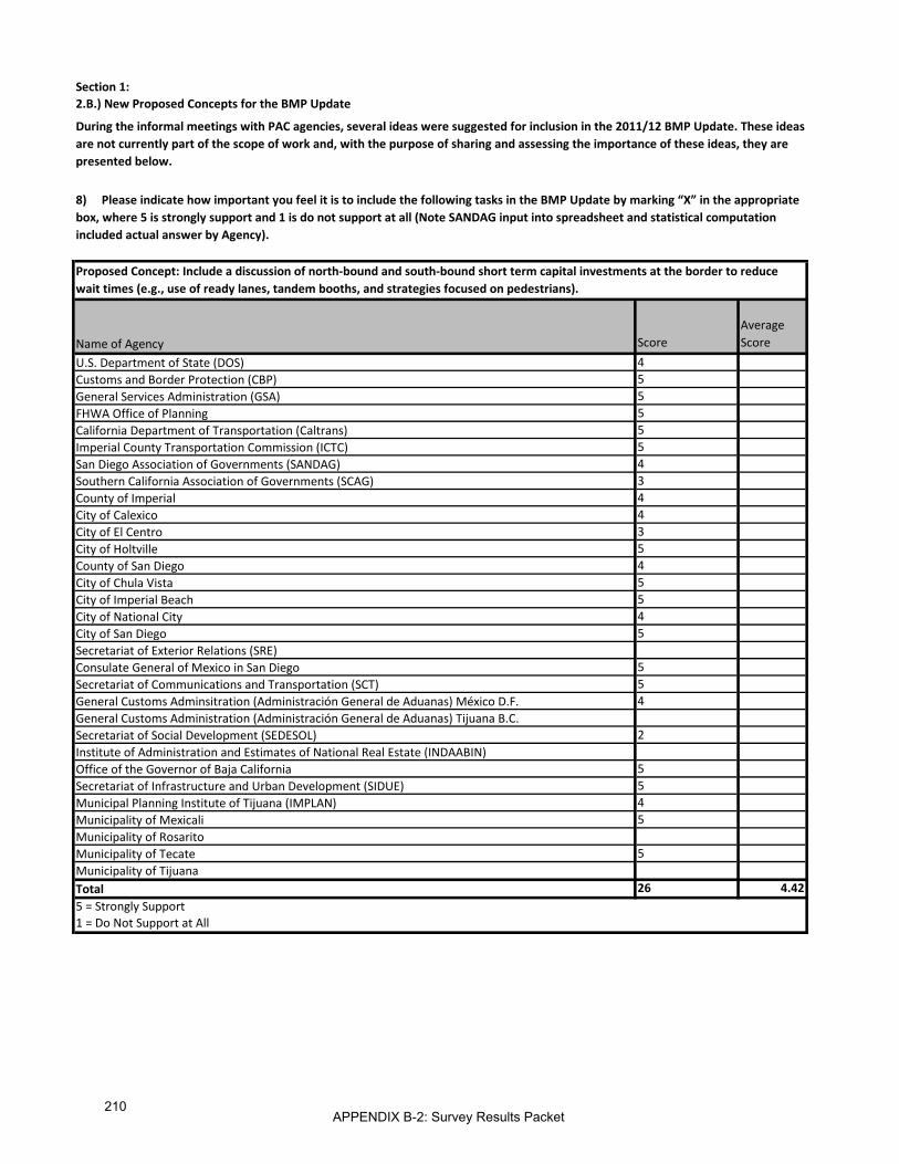
Section 1:2.B.) New Proposed Concepts for the BMP Update
8) Please indicate how important you feel it is to include the following tasks in the BMP Update by marking “X” in the appropriate box, where 5 is strongly support and 1 is do not support at all (Note SANDAG input into spreadsheet and statistical computation included actual answer by Agency).
During the informal meetings with PAC agencies, several ideas were suggested for inclusion in the 2011/12 BMP Update. These ideas are not currently part of the scope of work and, with the purpose of sharing and assessing the importance of these ideas, they are presented below.
Name of Agency ScoreAverage Score
U.S. Department of State (DOS) 4Customs and Border Protection (CBP) 5General Services Administration (GSA) 5FHWA Office of Planning 5California Department of Transportation (Caltrans) 5Imperial County Transportation Commission (ICTC) 5San Diego Association of Governments (SANDAG) 4Southern California Association of Governments (SCAG) 3County of Imperial 4City of Calexico 4City of El Centro 3City of Holtville 5County of San Diego 4City of Chula Vista 5City of Imperial Beach 5City of National City 4City of San Diego 5Secretariat of Exterior Relations (SRE)Consulate General of Mexico in San Diego 5Secretariat of Communications and Transportation (SCT) 5General Customs Adminsitration (Administración General de Aduanas) México D.F. 4General Customs Administration (Administración General de Aduanas) Tijuana B.C.Secretariat of Social Development (SEDESOL) 2Institute of Administration and Estimates of National Real Estate (INDAABIN)Office of the Governor of Baja California 5Secretariat of Infrastructure and Urban Development (SIDUE) 5Municipal Planning Institute of Tijuana (IMPLAN) 4Municipality of Mexicali 5Municipality of RosaritoMunicipality of Tecate 5Municipality of TijuanaTotal 26 4.425 = Strongly Support1 = Do Not Support at All
Proposed Concept: Include a discussion of north-bound and south-bound short term capital investments at the border to reduce wait times (e.g., use of ready lanes, tandem booths, and strategies focused on pedestrians).
APPENDIX B-2: Survey Results Packet210

Section 1:2.B.) New Proposed Concepts for the BMP Update
8) Please indicate how important you feel it is to include the following tasks in the BMP Update by marking “X” in the appropriate box, where 5 is strongly support and 1 is do not support at all (Note SANDAG input into spreadsheet and statistical computation included actual answer by Agency).
During the informal meetings with PAC agencies, several ideas were suggested for inclusion in the 2011/12 BMP Update. These ideas are not currently part of the scope of work and, with the purpose of sharing and assessing the importance of these ideas, they are presented below.
Name of Agency ScoreAverage Score
U.S. Department of State (DOS) 5Customs and Border Protection (CBP) 5General Services Administration (GSA) 5FHWA Office of Planning 5California Department of Transportation (Caltrans) 2Imperial County Transportation Commission (ICTC) 4San Diego Association of Governments (SANDAG) 2Southern California Association of Governments (SCAG) 4County of Imperial 5City of Calexico 4City of El Centro 4City of Holtville 4County of San Diego 3City of Chula Vista 5City of Imperial Beach 4City of National City 4City of San Diego 5Secretariat of Exterior Relations (SRE)Consulate General of Mexico in San Diego 4Secretariat of Communications and Transportation (SCT) 5General Customs Adminsitration (Administración General de Aduanas) México D.F. 5General Customs Administration (Administración General de Aduanas) Tijuana B.C.Secretariat of Social Development (SEDESOL) 5Institute of Administration and Estimates of National Real Estate (INDAABIN)Office of the Governor of Baja California 5Secretariat of Infrastructure and Urban Development (SIDUE) 5Municipal Planning Institute of Tijuana (IMPLAN) 5Municipality of Mexicali 5Municipality of RosaritoMunicipality of Tecate 5Municipality of TijuanaTotal 26 4.385 = Strongly Support1 = Do Not Support at All
Proposed Concept: Update existing and forecasted travel demand data for use in POE evaluation criteria for scoring the POE projects.
APPENDIX B-2: Survey Results Packet211
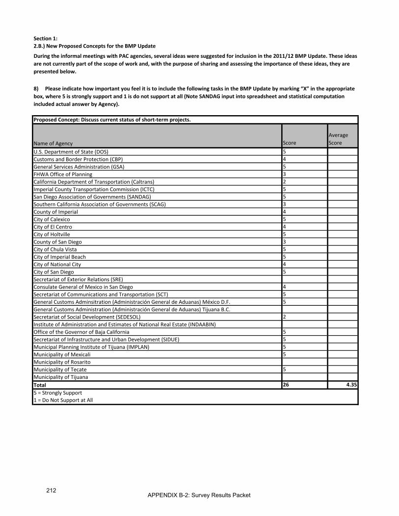
Section 1:2.B.) New Proposed Concepts for the BMP Update
8) Please indicate how important you feel it is to include the following tasks in the BMP Update by marking “X” in the appropriate box, where 5 is strongly support and 1 is do not support at all (Note SANDAG input into spreadsheet and statistical computation included actual answer by Agency).
During the informal meetings with PAC agencies, several ideas were suggested for inclusion in the 2011/12 BMP Update. These ideas are not currently part of the scope of work and, with the purpose of sharing and assessing the importance of these ideas, they are presented below.
Name of Agency ScoreAverage Score
U.S. Department of State (DOS) 5Customs and Border Protection (CBP) 4General Services Administration (GSA) 5FHWA Office of Planning 3California Department of Transportation (Caltrans) 2Imperial County Transportation Commission (ICTC) 5San Diego Association of Governments (SANDAG) 5Southern California Association of Governments (SCAG) 3County of Imperial 4City of Calexico 5City of El Centro 4City of Holtville 5County of San Diego 3City of Chula Vista 5City of Imperial Beach 5City of National City 4City of San Diego 5Secretariat of Exterior Relations (SRE)Consulate General of Mexico in San Diego 4Secretariat of Communications and Transportation (SCT) 5General Customs Adminsitration (Administración General de Aduanas) México D.F. 5General Customs Administration (Administración General de Aduanas) Tijuana B.C.Secretariat of Social Development (SEDESOL) 2Institute of Administration and Estimates of National Real Estate (INDAABIN)Office of the Governor of Baja California 5Secretariat of Infrastructure and Urban Development (SIDUE) 5Municipal Planning Institute of Tijuana (IMPLAN) 5Municipality of Mexicali 5Municipality of RosaritoMunicipality of Tecate 5Municipality of TijuanaTotal 26 4.355 = Strongly Support1 = Do Not Support at All
Proposed Concept: Discuss current status of short-term projects.
APPENDIX B-2: Survey Results Packet212

Section 1:2.B.) New Proposed Concepts for the BMP Update
8) Please indicate how important you feel it is to include the following tasks in the BMP Update by marking “X” in the appropriate box, where 5 is strongly support and 1 is do not support at all (Note SANDAG input into spreadsheet and statistical computation included actual answer by Agency).
During the informal meetings with PAC agencies, several ideas were suggested for inclusion in the 2011/12 BMP Update. These ideas are not currently part of the scope of work and, with the purpose of sharing and assessing the importance of these ideas, they are presented below.
Name of Agency ScoreAverage Score
U.S. Department of State (DOS) 4Customs and Border Protection (CBP) 5General Services Administration (GSA) 5FHWA Office of Planning 5California Department of Transportation (Caltrans) 1Imperial County Transportation Commission (ICTC) 4San Diego Association of Governments (SANDAG) 2Southern California Association of Governments (SCAG) 5County of Imperial 5City of Calexico 4City of El Centro 4City of Holtville 5County of San Diego 4City of Chula Vista 4City of Imperial Beach 4City of National City 4City of San Diego 5Secretariat of Exterior Relations (SRE)Consulate General of Mexico in San Diego 4Secretariat of Communications and Transportation (SCT) 5General Customs Adminsitration (Administración General de Aduanas) México D.F. 5General Customs Administration (Administración General de Aduanas) Tijuana B.C.Secretariat of Social Development (SEDESOL) 5Institute of Administration and Estimates of National Real Estate (INDAABIN)Office of the Governor of Baja California 4Secretariat of Infrastructure and Urban Development (SIDUE) 4Municipal Planning Institute of Tijuana (IMPLAN) 5Municipality of Mexicali 5Municipality of RosaritoMunicipality of Tecate 5Municipality of TijuanaTotal 26 4.315 = Strongly Support1 = Do Not Support at All
Proposed Concept: Update existing cross border wait times for use in POE evaluation criteria for scoring the POE projects.
APPENDIX B-2: Survey Results Packet213
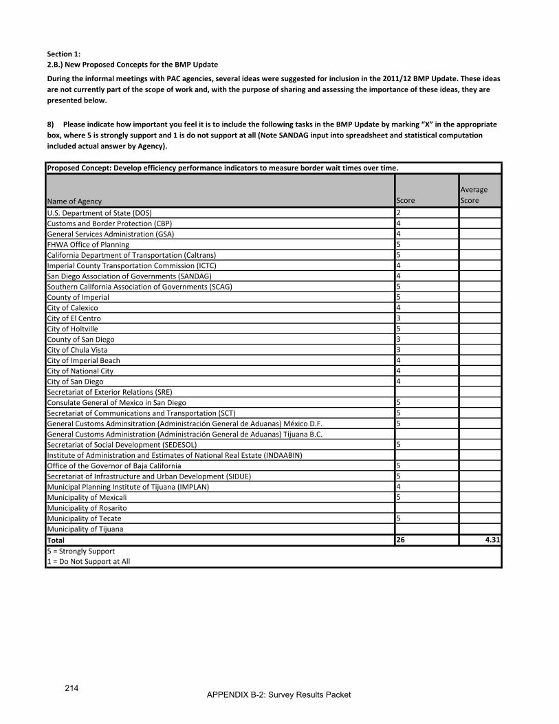
Section 1:2.B.) New Proposed Concepts for the BMP Update
8) Please indicate how important you feel it is to include the following tasks in the BMP Update by marking “X” in the appropriate box, where 5 is strongly support and 1 is do not support at all (Note SANDAG input into spreadsheet and statistical computation included actual answer by Agency).
During the informal meetings with PAC agencies, several ideas were suggested for inclusion in the 2011/12 BMP Update. These ideas are not currently part of the scope of work and, with the purpose of sharing and assessing the importance of these ideas, they are presented below.
Name of Agency ScoreAverage Score
U.S. Department of State (DOS) 2Customs and Border Protection (CBP) 4General Services Administration (GSA) 4FHWA Office of Planning 5California Department of Transportation (Caltrans) 5Imperial County Transportation Commission (ICTC) 4San Diego Association of Governments (SANDAG) 4Southern California Association of Governments (SCAG) 5County of Imperial 5City of Calexico 4City of El Centro 3City of Holtville 5County of San Diego 3City of Chula Vista 3City of Imperial Beach 4City of National City 4City of San Diego 4Secretariat of Exterior Relations (SRE)Consulate General of Mexico in San Diego 5Secretariat of Communications and Transportation (SCT) 5General Customs Adminsitration (Administración General de Aduanas) México D.F. 5General Customs Administration (Administración General de Aduanas) Tijuana B.C.Secretariat of Social Development (SEDESOL) 5Institute of Administration and Estimates of National Real Estate (INDAABIN)Office of the Governor of Baja California 5Secretariat of Infrastructure and Urban Development (SIDUE) 5Municipal Planning Institute of Tijuana (IMPLAN) 4Municipality of Mexicali 5Municipality of RosaritoMunicipality of Tecate 5Municipality of TijuanaTotal 26 4.315 = Strongly Support1 = Do Not Support at All
Proposed Concept: Develop efficiency performance indicators to measure border wait times over time.
APPENDIX B-2: Survey Results Packet214

Section 1:2.B.) New Proposed Concepts for the BMP Update
8) Please indicate how important you feel it is to include the following tasks in the BMP Update by marking “X” in the appropriate box, where 5 is strongly support and 1 is do not support at all (Note SANDAG input into spreadsheet and statistical computation included actual answer by Agency).
During the informal meetings with PAC agencies, several ideas were suggested for inclusion in the 2011/12 BMP Update. These ideas are not currently part of the scope of work and, with the purpose of sharing and assessing the importance of these ideas, they are presented below.
Name of Agency ScoreAverage Score
U.S. Department of State (DOS) 4Customs and Border Protection (CBP) 5General Services Administration (GSA) 2FHWA Office of Planning 4California Department of Transportation (Caltrans) 4Imperial County Transportation Commission (ICTC) 3San Diego Association of Governments (SANDAG) 3Southern California Association of Governments (SCAG) 5County of Imperial 5City of Calexico 4City of El Centro 4City of Holtville 5County of San Diego 4City of Chula Vista 4City of Imperial Beach 3City of National City 4City of San Diego 5Secretariat of Exterior Relations (SRE)Consulate General of Mexico in San Diego 5Secretariat of Communications and Transportation (SCT) 5General Customs Administration (Administración General de Aduanas) México D.F. 4General Customs Administration (Administración General de Aduanas) Tijuana B.C.Secretariat of Social Development (SEDESOL) 5Institute of Administration and Estimates of National Real Estate (INDAABIN)Office of the Governor of Baja California 3Secretariat of Infrastructure and Urban Development (SIDUE) 3Municipal Planning Institute of Tijuana (IMPLAN) 5Municipality of Mexicali 5Municipality of RosaritoMunicipality of Tecate 5Municipality of TijuanaTotal 26 4.155 = Strongly Support1 = Do Not Support at All
Proposed Concept: Discuss potential of creating a web portal to provide updated information on cross border projects and efforts.
APPENDIX B-2: Survey Results Packet215

Section 1:2.B.) New Proposed Concepts for the BMP Update
8) Please indicate how important you feel it is to include the following tasks in the BMP Update by marking “X” in the appropriate box, where 5 is strongly support and 1 is do not support at all (Note SANDAG input into spreadsheet and statistical computation included actual answer by Agency).
During the informal meetings with PAC agencies, several ideas were suggested for inclusion in the 2011/12 BMP Update. These ideas are not currently part of the scope of work and, with the purpose of sharing and assessing the importance of these ideas, they are presented below.
Name of Agency ScoreAverage Score
U.S. Department of State (DOS) 5Customs and Border Protection (CBP) 4General Services Administration (GSA) 3FHWA Office of Planning 3California Department of Transportation (Caltrans) 3Imperial County Transportation Commission (ICTC) 4San Diego Association of Governments (SANDAG) 5Southern California Association of Governments (SCAG) 5County of Imperial 5City of Calexico 4City of El Centro 3City of Holtville 5County of San Diego 4City of Chula Vista 5City of Imperial Beach 4City of National City 3City of San DiegoSecretariat of Exterior Relations (SRE)Consulate General of Mexico in San Diego 4Secretariat of Communications and Transportation (SCT) 3General Customs Adminsitration (Administración General de Aduanas) México D.F. 4General Customs Administration (Administración General de Aduanas) Tijuana B.C.Secretariat of Social Development (SEDESOL) 5Institute of Administration and Estimates of National Real Estate (INDAABIN)Office of the Governor of Baja California 4Secretariat of Infrastructure and Urban Development (SIDUE) 4Municipal Planning Institute of Tijuana (IMPLAN) 4Municipality of Mexicali 5Municipality of RosaritoMunicipality of Tecate 5Municipality of TijuanaTotal 25 4.125 = Strongly Support1 = Do Not Support at All
Proposed Concept: Prepare specific recommendations and action items for appropriate agencies regarding implementing the findings as part of the next steps in the BMP process.
APPENDIX B-2: Survey Results Packet216

Section 1:2.B.) New Proposed Concepts for the BMP Update
8) Please indicate how important you feel it is to include the following tasks in the BMP Update by marking “X” in the appropriate box, where 5 is strongly support and 1 is do not support at all (Note SANDAG input into spreadsheet and statistical computation included actual answer by Agency).
During the informal meetings with PAC agencies, several ideas were suggested for inclusion in the 2011/12 BMP Update. These ideas are not currently part of the scope of work and, with the purpose of sharing and assessing the importance of these ideas, they are presented below.
Name of Agency ScoreAverage Score
U.S. Department of State (DOS) 5Customs and Border Protection (CBP) 5General Services Administration (GSA) 5FHWA Office of Planning 5California Department of Transportation (Caltrans) 2Imperial County Transportation Commission (ICTC) 5San Diego Association of Governments (SANDAG) 2Southern California Association of Governments (SCAG) 5County of Imperial 5City of Calexico 4City of El Centro 4City of Holtville 5County of San Diego 3City of Chula Vista 4City of Imperial Beach 3City of National City 4City of San Diego 5Secretariat of Exterior Relations (SRE)Consulate General of Mexico in San Diego 3Secretariat of Communications and Transportation (SCT) 5General Customs Administration (Administración General de Aduanas) México D.F. 5General Customs Administration (Administración General de Aduanas) Tijuana B.C.Secretariat of Social Development (SEDESOL) 5Institute of Administration and Estimates of National Real Estate (INDAABIN)Office of the Governor of Baja California 1Secretariat of Infrastructure and Urban Development (SIDUE) 1Municipal Planning Institute of Tijuana (IMPLAN) 5Municipality of Mexicali 5Municipality of RosaritoMunicipality of Tecate 4Municipality of TijuanaTotal 26 4.045 = Strongly Support1 = Do Not Support at All
Proposed Concept: Re-rank the POE projects based on updated information.
APPENDIX B-2: Survey Results Packet217
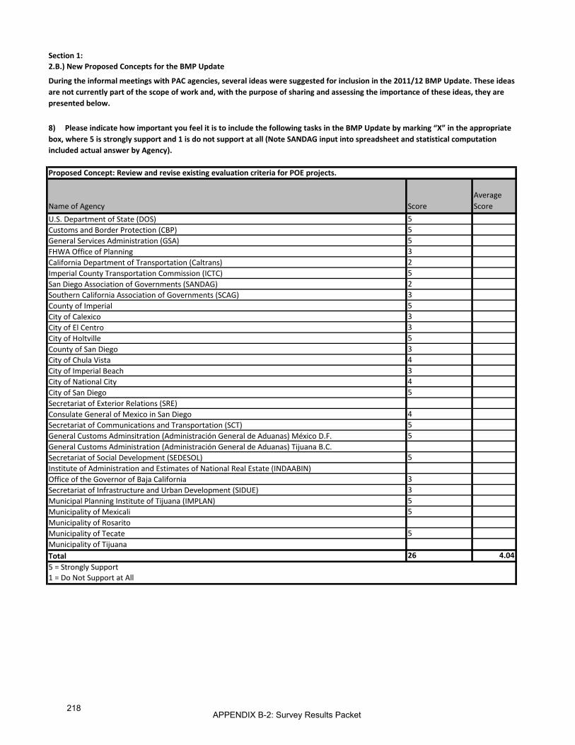
Section 1:2.B.) New Proposed Concepts for the BMP Update
8) Please indicate how important you feel it is to include the following tasks in the BMP Update by marking “X” in the appropriate box, where 5 is strongly support and 1 is do not support at all (Note SANDAG input into spreadsheet and statistical computation included actual answer by Agency).
During the informal meetings with PAC agencies, several ideas were suggested for inclusion in the 2011/12 BMP Update. These ideas are not currently part of the scope of work and, with the purpose of sharing and assessing the importance of these ideas, they are presented below.
Name of Agency ScoreAverage Score
U.S. Department of State (DOS) 5Customs and Border Protection (CBP) 5General Services Administration (GSA) 5FHWA Office of Planning 3California Department of Transportation (Caltrans) 2Imperial County Transportation Commission (ICTC) 5San Diego Association of Governments (SANDAG) 2Southern California Association of Governments (SCAG) 3County of Imperial 5City of Calexico 3City of El Centro 3City of Holtville 5County of San Diego 3City of Chula Vista 4City of Imperial Beach 3City of National City 4City of San Diego 5Secretariat of Exterior Relations (SRE)Consulate General of Mexico in San Diego 4Secretariat of Communications and Transportation (SCT) 5General Customs Adminsitration (Administración General de Aduanas) México D.F. 5General Customs Administration (Administración General de Aduanas) Tijuana B.C.Secretariat of Social Development (SEDESOL) 5Institute of Administration and Estimates of National Real Estate (INDAABIN)Office of the Governor of Baja California 3Secretariat of Infrastructure and Urban Development (SIDUE) 3Municipal Planning Institute of Tijuana (IMPLAN) 5Municipality of Mexicali 5Municipality of RosaritoMunicipality of Tecate 5Municipality of TijuanaTotal 26 4.045 = Strongly Support1 = Do Not Support at All
Proposed Concept: Review and revise existing evaluation criteria for POE projects.
APPENDIX B-2: Survey Results Packet218

Section 1:2.B.) New Proposed Concepts for the BMP Update
8) Please indicate how important you feel it is to include the following tasks in the BMP Update by marking “X” in the appropriate box, where 5 is strongly support and 1 is do not support at all (Note SANDAG input into spreadsheet and statistical computation included actual answer by Agency).
During the informal meetings with PAC agencies, several ideas were suggested for inclusion in the 2011/12 BMP Update. These ideas are not currently part of the scope of work and, with the purpose of sharing and assessing the importance of these ideas, they are presented below.
Name of Agency ScoreAverage Score
U.S. Department of State (DOS) 5Customs and Border Protection (CBP) 4General Services Administration (GSA) 4FHWA Office of Planning 5California Department of Transportation (Caltrans) 2Imperial County Transportation Commission (ICTC) 5San Diego Association of Governments (SANDAG) 2Southern California Association of Governments (SCAG) 5County of Imperial 5City of Calexico 3City of El Centro 4City of Holtville 5County of San Diego 3City of Chula Vista 4City of Imperial Beach 3City of National City 4City of San Diego 5Secretariat of Exterior Relations (SRE)Consulate General of Mexico in San Diego 3Secretariat of Communications and Transportation (SCT) 5General Customs Adminsitration (Administración General de Aduanas) México D.F. 4General Customs Administration (Administración General de Aduanas) Tijuana B.C.Secretariat of Social Development (SEDESOL) 5Institute of Administration and Estimates of National Real Estate (INDAABIN)Office of the Governor of Baja California 1Secretariat of Infrastructure and Urban Development (SIDUE) 1Municipal Planning Institute of Tijuana (IMPLAN) 5Municipality of Mexicali 5Municipality of RosaritoMunicipality of Tecate 5Municipality of TijuanaTotal 26 3.925 = Strongly Support1 = Do Not Support at All
Proposed Concept: Re-rank the transportation projects based on updated information.
APPENDIX B-2: Survey Results Packet219

Section 1:2.B.) New Proposed Concepts for the BMP Update
8) Please indicate how important you feel it is to include the following tasks in the BMP Update by marking “X” in the appropriate box, where 5 is strongly support and 1 is do not support at all (Note SANDAG input into spreadsheet and statistical computation included actual answer by Agency).
During the informal meetings with PAC agencies, several ideas were suggested for inclusion in the 2011/12 BMP Update. These ideas are not currently part of the scope of work and, with the purpose of sharing and assessing the importance of these ideas, they are presented below.
Name of Agency ScoreAverage Score
U.S. Department of State (DOS) 5Customs and Border Protection (CBP) 4General Services Administration (GSA) 3FHWA Office of Planning 3California Department of Transportation (Caltrans) 2Imperial County Transportation Commission (ICTC) 5San Diego Association of Governments (SANDAG) 2Southern California Association of Governments (SCAG) 4County of Imperial 5City of Calexico 3City of El Centro 3City of Holtville 5County of San Diego 3City of Chula Vista 4City of Imperial Beach 4City of National City 4City of San Diego 5Secretariat of Exterior Relations (SRE)Consulate General of Mexico in San Diego 3Secretariat of Communications and Transportation (SCT) 5General Customs Adminsitration (Administración General de Aduanas) México D.F. 4General Customs Administration (Administración General de Aduanas) Tijuana B.C.Secretariat of Social Development (SEDESOL) 5Institute of Administration and Estimates of National Real Estate (INDAABIN)Office of the Governor of Baja California 3Secretariat of Infrastructure and Urban Development (SIDUE) 3Municipal Planning Institute of Tijuana (IMPLAN) 5Municipality of Mexicali 5Municipality of RosaritoMunicipality of Tecate 5Municipality of TijuanaTotal 26 3.925 = Strongly Support1 = Do Not Support at All
Proposed Concept: Review and revise existing evaluation criteria for roadway, interchange, and rail projects.
APPENDIX B-2: Survey Results Packet220
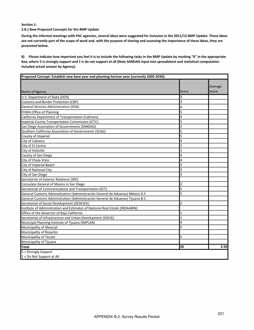
Section 1:2.B.) New Proposed Concepts for the BMP Update
8) Please indicate how important you feel it is to include the following tasks in the BMP Update by marking “X” in the appropriate box, where 5 is strongly support and 1 is do not support at all (Note SANDAG input into spreadsheet and statistical computation included actual answer by Agency).
During the informal meetings with PAC agencies, several ideas were suggested for inclusion in the 2011/12 BMP Update. These ideas are not currently part of the scope of work and, with the purpose of sharing and assessing the importance of these ideas, they are presented below.
Name of Agency ScoreAverage Score
U.S. Department of State (DOS) 3Customs and Border Protection (CBP) 3General Services Administration (GSA) 4FHWA Office of Planning 5California Department of Transportation (Caltrans) 4Imperial County Transportation Commission (ICTC) 5San Diego Association of Governments (SANDAG) 2Southern California Association of Governments (SCAG) 5County of Imperial 5City of Calexico 4City of El Centro 2City of Holtville 1County of San Diego 4City of Chula Vista 4City of Imperial Beach 2City of National City 3City of San Diego 5Secretariat of Exterior Relations (SRE)Consulate General of Mexico in San Diego 2Secretariat of Communications and Transportation (SCT) 5General Customs Adminsitration (Administración General de Aduanas) México D.F. 5General Customs Administration (Administración General de Aduanas) Tijuana B.C.Secretariat of Social Development (SEDESOL) 2Institute of Administration and Estimates of National Real Estate (INDAABIN)Office of the Governor of Baja California 1Secretariat of Infrastructure and Urban Development (SIDUE) 1Municipal Planning Institute of Tijuana (IMPLAN) 4Municipality of Mexicali 5Municipality of RosaritoMunicipality of Tecate 5Municipality of TijuanaTotal 26 3.505 = Strongly Support1 = Do Not Support at All
Proposed Concept: Establish new base year and planning horizon year (currently 2005-2030).
APPENDIX B-2: Survey Results Packet221

Section 2: Scope of Work2.B.) New Proposed Concepts for the BMP Update
Establish new base year and planning horizon year (currently 2005-2030).
Please write in proposed planning horizon below:
Name of Agency ScoreU.S. Department of State (DOS) - U.S. Consulate General - Tijuana
Customs and Border Protection (CBP)General Services Administration (GSA) Given the long lead time for these
major projects, the horizon should be a 20 – 25 year look forward.
FHWA Office of Planning 2045California Department of Transportation (Caltrans) 2011-2050 to match SANDAG’s RTP
UpdateImperial County Transportation Commission (ICTC) 2035San Diego Association of Governments (SANDAG) 2050Southern California Association of Governments (SCAG) 2035County of Imperial Update according to current RTP
planning years.City of CalexicoCity of El CentroCity of HoltvilleCounty of San Diego 2050City of Chula VistaCity of Imperial BeachCity of National CityCity of San DiegoSecretariat of Exterior Relations (SRE)Consulate General of Mexico in San DiegoSecretariat of Communications and Transportation (SCT) 2040General Customs Adminsitration (Administración General de Aduanas) México D.F.
2012-2018
General Customs Administration (Administración General de Aduanas) Tijuana B.C.Secretariat of Social Development (SEDESOL)Institute of Administration and Estimates of National Real Estate (INDAABIN)Office of the Governor of Baja CaliforniaSecretariat of Infrastructure and Urban Development (SIDUE)Municipal Planning Institute of Tijuana (IMPLAN) 2012-2037Municipality of Mexicali 2050Municipality of RosaritoMunicipality of TecateMunicipality of TijuanaNational Immigration Institute (INM)Secretariat of Economic Development Baja CaliforniaBaja California Secretariat of TourismSecretariat of Municipal Economic Development TijuanaTotal 12
APPENDIX B-2: Survey Results Packet222
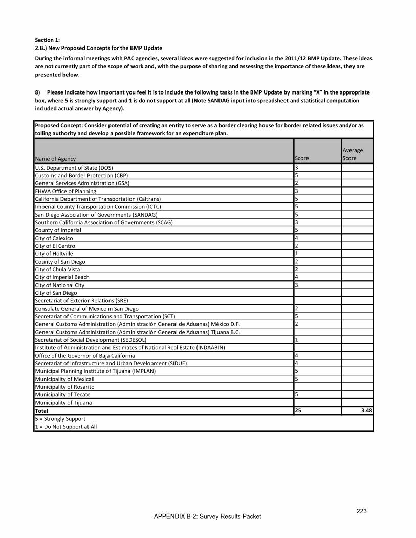
Section 1:2.B.) New Proposed Concepts for the BMP Update
Name of Agency ScoreAverage Score
U.S. Department of State (DOS) 3Customs and Border Protection (CBP) 5General Services Administration (GSA) 2FHWA Office of Planning 3California Department of Transportation (Caltrans) 5Imperial County Transportation Commission (ICTC) 5San Diego Association of Governments (SANDAG) 5Southern California Association of Governments (SCAG) 3County of Imperial 5City of Calexico 4City of El Centro 2City of Holtville 1County of San Diego 2City of Chula Vista 2City of Imperial Beach 4City of National City 3City of San DiegoSecretariat of Exterior Relations (SRE)Consulate General of Mexico in San Diego 2Secretariat of Communications and Transportation (SCT) 5General Customs Administration (Administración General de Aduanas) México D.F. 2General Customs Administration (Administración General de Aduanas) Tijuana B.C.Secretariat of Social Development (SEDESOL) 1Institute of Administration and Estimates of National Real Estate (INDAABIN)Office of the Governor of Baja California 4Secretariat of Infrastructure and Urban Development (SIDUE) 4Municipal Planning Institute of Tijuana (IMPLAN) 5Municipality of Mexicali 5Municipality of RosaritoMunicipality of Tecate 5Municipality of TijuanaTotal 25 3.485 = Strongly Support1 = Do Not Support at All
8) Please indicate how important you feel it is to include the following tasks in the BMP Update by marking “X” in the appropriate box, where 5 is strongly support and 1 is do not support at all (Note SANDAG input into spreadsheet and statistical computation included actual answer by Agency).
During the informal meetings with PAC agencies, several ideas were suggested for inclusion in the 2011/12 BMP Update. These ideas are not currently part of the scope of work and, with the purpose of sharing and assessing the importance of these ideas, they are presented below.
Proposed Concept: Consider potential of creating an entity to serve as a border clearing house for border related issues and/or as tolling authority and develop a possible framework for an expenditure plan.
APPENDIX B-2: Survey Results Packet223

[This page was left intentionally blank]
APPENDIX B-2: Survey Results Packet224

Responses to Quantitative Portion (Questions 1-6; 9-11)
APPENDIX B-2: Survey Results Packet225

[This page was left intentionally blank]
APPENDIX B-2: Survey Results Packet226

Question 1: Planning/Funding Processes: Has your agency used the 2008 California-Baja California BMP in your agency’s planning/funding processes? (For example, used the BMP to identify transportation or Port of Entry (POE) needs, advance existing projects listed in the BMP, propose new transportation facilities or POE projects, request and/or obtain funding, etc.)?
Agency Yes or no? a. If yes, please describe how your agency has used the
2008 California-Baja California BMP in your agency’s planning processes?
b. If not, please explain
U.S. Department of State (DOS)
Yes US Department of State has used the 2008 CA-Baja CA BMP as a reference in binational border crossing consultations with the Government of Mexico, in federal policy meetings in Washington, and in its review of recent Presidential Permit applications.
-
U.S. Customs and Border Protection (CBP)
Yes CBP has relied on the findings of the 2008 California-Baja California BMP to identify LPOE capital construction priorities in the region and advance those projects to the extent of the available federal appropriations.
-
U.S. General Services Administration (GSA)
Yes The General Services Administration uses resources like the BMP to document regional support for our projects. Information like the BMP assists GSA and our customer agencies with prioritizing our projects.
-
U.S. Federal Highway Administration (FHWA)
Yes In coordination with Caltrans, FHWA has used the findings from the 2008 California-Baja California BMP to identify and prioritize the region’s needs, ensuring the efforts are consistent with Mexico’s border plans. The information from the BMP is implemented in state and local improvement plans which is a Federal aid requirement when applying Federal-aid funds to a project.
Also, we have use the California BMP as an example for the other bother regions. FHWA is advocating Binational Regional Border Master plans for the entire border.
-
APPENDIX B-2: Survey Results Packet227

Question 1: Planning/Funding Processes: Has your agency used the 2008 California-Baja California BMP in your agency’s planning/funding processes? (For example, used the BMP to identify transportation or Port of Entry (POE) needs, advance existing projects listed in the BMP, propose new transportation facilities or POE projects, request and/or obtain funding, etc.)?
Agency Yes or no? a. If yes, please describe how your agency has used the
2008 California-Baja California BMP in your agency’s planning processes?
b. If not, please explain
California Department of Transportation (Caltrans)
Yes Caltrans has used the BMP in the following activities:
• Coordination on the development of Regional Transportation Plans for SANDAG and SCAG
• Long-term projections of trucking patterns
• Proposing Intelligent Transportation Systems (ITS) solutions within the D-11 ITS Master Plan
• Identifying action items in the annual Caltrans Goods Movement (Freight Planning) Business Plan
• Supporting miscellaneous data analysis requests and research
-
Imperial County Transportation Commission (ICTC)
Yes Transportation priorities in BMP have been incorporated into Imperial County's proposed Revenue Constrained and Unconstrained priorities for the 2012 Southern California Association Governments (SCAG) RTP in progress and scheduled for approval in April 2012.
Also, as our primary reference for advancing POE and connecting roadway infrastructure with Imperial's border region.
-
APPENDIX B-2: Survey Results Packet228

Question 1: Planning/Funding Processes: Has your agency used the 2008 California-Baja California BMP in your agency’s planning/funding processes? (For example, used the BMP to identify transportation or Port of Entry (POE) needs, advance existing projects listed in the BMP, propose new transportation facilities or POE projects, request and/or obtain funding, etc.)?
Agency Yes or no? a. If yes, please describe how your agency has used the
2008 California-Baja California BMP in your agency’s planning processes?
b. If not, please explain
San Diego Association of Governments (SANDAG)
Yes SANDAG used the 2008 BMP to assist with planning for the new Otay Mesa East Port of Entry project, which ranked number one among POEs in the BMP. The BMP served as formal documentation of the region’s priorities regarding border infrastructure and therefore helped provide justification for the new border crossing.
SANDAG used information contained in the BMP to assist with the development of the 2050 Regional Transportation Plan (RTP): Our Region Our Future. The 2008 BMP is described in Chapter 6 of the 2050 RTP, including the ranking of the port of entry projects (Page 6-74).
The BMP has been used as a means of providing information to stakeholders about the border region. The Plan provides a useful definition of the border region as well as descriptions of projects in the area.
N/A
Southern California Association of Governments (SCAG)
Yes Used in development of the congestion management process for the 2012 Regional Transportation Plan
-
APPENDIX B-2: Survey Results Packet229

Question 1: Planning/Funding Processes: Has your agency used the 2008 California-Baja California BMP in your agency’s planning/funding processes? (For example, used the BMP to identify transportation or Port of Entry (POE) needs, advance existing projects listed in the BMP, propose new transportation facilities or POE projects, request and/or obtain funding, etc.)?
Agency Yes or no? a. If yes, please describe how your agency has used the
2008 California-Baja California BMP in your agency’s planning processes?
b. If not, please explain
County of Imperial
Yes The County of Imperial has greatly benefitted from the 2008 California-Baja California BMP as justification when seeking funding for local projects; including lobbying Congress for the funds for the construction of the Calexico West Land POE. In addition, projects that involve the local transportation system.
-
City of Calexico No - 2008 California-Baja California BMP has not being taken in consideration because the staff that was involved with this 2008 study no longer works in the city and said report final report never made to this office.
City of El Centro
Yes As support for requesting funding from grants -
City of Holtville Yes The City of Holtville utilized the 2008 BMP in the city’s transportation planning and land use planning program.
-
APPENDIX B-2: Survey Results Packet230

Question 1: Planning/Funding Processes: Has your agency used the 2008 California-Baja California BMP in your agency’s planning/funding processes? (For example, used the BMP to identify transportation or Port of Entry (POE) needs, advance existing projects listed in the BMP, propose new transportation facilities or POE projects, request and/or obtain funding, etc.)?
Agency Yes or no? a. If yes, please describe how your agency has used the
2008 California-Baja California BMP in your agency’s planning processes?
b. If not, please explain
County of San Diego
No N/A
Many of the same land use and infrastructure assumptions utilized in the development of the 2008 BMP were previously incorporated into the County’s General Plan Update and East Otay Mesa Specific Plan. By September of 2008 when the BMP was finalized, the County had already completed the bulk of the land use plan for the General Plan Update and begun preparation and review of the EIR for the General Plan Update. The General Plan was adopted by the Board of Supervisors in August of 2011. Future updates to the County’s General Plan and East Otay Mesa Specific Plan will take into consideration the Findings and Recommendations of the BMP.
City of Chula Vista
No - There is a general lack of understanding of the relationship and relevance of the BMP to local planning and funding actions. If jurisdictions were better briefed and/or the document contained a section describing local applications, it would be beneficial.
City of Imperial Beach
No - Didn’t know enough about it to make use of it. Imperial Beach is not on the main routes to and from POEs.
City of National City
No - We were not made aware of the 2008 California-Baja California BMP.
APPENDIX B-2: Survey Results Packet231

Question 1: Planning/Funding Processes: Has your agency used the 2008 California-Baja California BMP in your agency’s planning/funding processes? (For example, used the BMP to identify transportation or Port of Entry (POE) needs, advance existing projects listed in the BMP, propose new transportation facilities or POE projects, request and/or obtain funding, etc.)?
Agency Yes or no? a. If yes, please describe how your agency has used the
2008 California-Baja California BMP in your agency’s planning processes?
b. If not, please explain
City of San Diego
No - While we have not used the BMP, the Otay Mesa and San Ysidro community plans include references to the ports of entry in these communities, along with land use policies for properties in close proximity to the ports.
SRE
Consulate of Mexico in San Diego
No The Consulate General doesn’t have the responsibility to conduct planning or financing activities, these are solely functions of the Secretariat of Foreign Affairs
-
Secretaría de Comunicaciones y Transporte (SCT)
Yes Was utilized to define investment programs for the short, medium, and long terms.
-
General Customs Administration
(Administración General de Aduanas)
México D.F.
Yes Advance existing projects, in accordance with results of prioritization
-
APPENDIX B-2: Survey Results Packet232
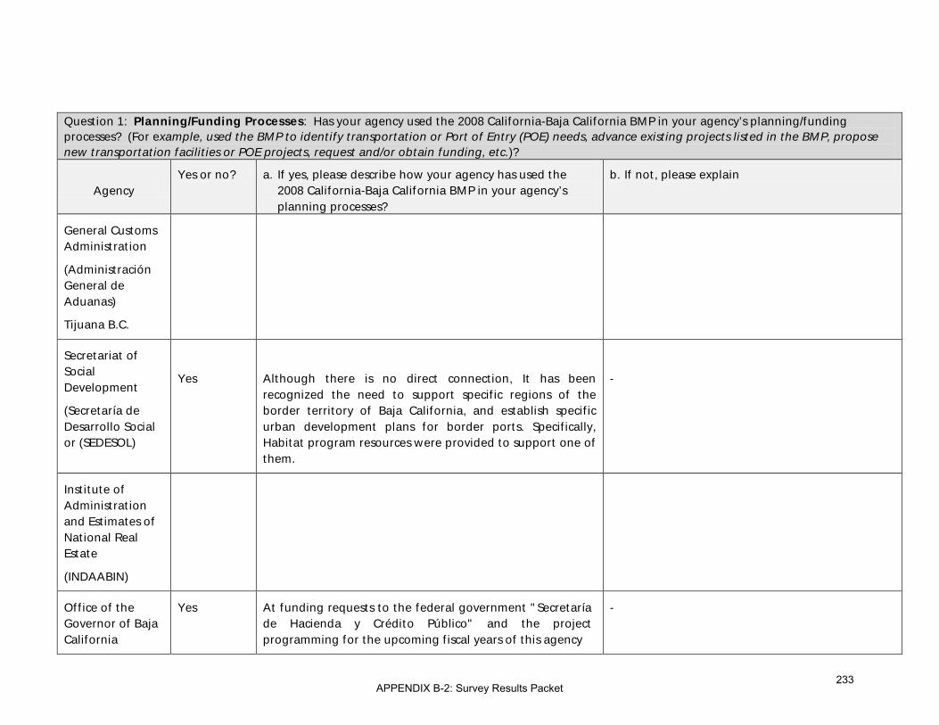
Question 1: Planning/Funding Processes: Has your agency used the 2008 California-Baja California BMP in your agency’s planning/funding processes? (For example, used the BMP to identify transportation or Port of Entry (POE) needs, advance existing projects listed in the BMP, propose new transportation facilities or POE projects, request and/or obtain funding, etc.)?
Agency Yes or no? a. If yes, please describe how your agency has used the
2008 California-Baja California BMP in your agency’s planning processes?
b. If not, please explain
General Customs Administration
(Administración General de Aduanas)
Tijuana B.C.
Secretariat of Social Development
(Secretaría de Desarrollo Social or (SEDESOL)
Yes
Although there is no direct connection, It has been recognized the need to support specific regions of the border territory of Baja California, and establish specific urban development plans for border ports. Specifically, Habitat program resources were provided to support one of them.
-
Institute of Administration and Estimates of National Real Estate
(INDAABIN)
Office of the Governor of Baja California
Yes At funding requests to the federal government "Secretaría de Hacienda y Crédito Público" and the project programming for the upcoming fiscal years of this agency
-
APPENDIX B-2: Survey Results Packet233

Question 1: Planning/Funding Processes: Has your agency used the 2008 California-Baja California BMP in your agency’s planning/funding processes? (For example, used the BMP to identify transportation or Port of Entry (POE) needs, advance existing projects listed in the BMP, propose new transportation facilities or POE projects, request and/or obtain funding, etc.)?
Agency Yes or no? a. If yes, please describe how your agency has used the
2008 California-Baja California BMP in your agency’s planning processes?
b. If not, please explain
Secretariat of Infrastructure and Urban Development (SIDUE)
Yes At funding requests to the federal government "Secretaría de Hacienda y Crédito Público" and the project programming for the upcoming fiscal years of this agency
-
Institúto Municipal de Planeación de Tijuana (IMPLAN)
Yes It was used in the Update of the Development Urban Population Center Plan Tijuana, B.C. (2010-2030), published in 2010.
It was used as a planning reference for the Update of the Decree of Otay Mesa Destination, which was recently published in the Official Gazette of the State Government of Baja California.
-
Municipality of Mexicali
No The Federal and State governments undertake studies and projects on this field; the municipality only supports them.
-
Municipality of Rosarito
Municipality of Tecate
Yes Is an input that has helped the definition of projects of municipal interest such as: “Ducto Fiscal”- enabling “Avenida México Oriente” to channel export cargo traffic
-
APPENDIX B-2: Survey Results Packet234

Question 1: Planning/Funding Processes: Has your agency used the 2008 California-Baja California BMP in your agency’s planning/funding processes? (For example, used the BMP to identify transportation or Port of Entry (POE) needs, advance existing projects listed in the BMP, propose new transportation facilities or POE projects, request and/or obtain funding, etc.)?
Agency Yes or no? a. If yes, please describe how your agency has used the
2008 California-Baja California BMP in your agency’s planning processes?
b. If not, please explain
Municipality of Tijuana
APPENDIX B-2: Survey Results Packet235

Question 2: Planning/Funding Documents: Has your agency included aspects of the 2008 California- Baja California BMP into your agency’s planning/funding-related documents1?
Agency Yes or no? b. If yes, please describe c. If not, please explain
U.S. Department of State (DOS)
No - US Dept of State uses the BMP to review and coordinate other agencies’ work, but is not itself involved in funding or building projects on the border.
U.S. Customs and Border Protection (CBP)
Yes CBP’s investment plans and planning documentation are in close correlation with the recommendations of the 2008 California-Baja California BMP in terms of the LPOE projects focus and priority setting in the region.
-
U.S. General Services Administration (GSA)
No - Land ports of entry have long lead times in development and the 2008 BMP endorsed a number of projects already in the pipeline. That said, GSA hopes the next iteration of the BMP will include smaller dollar projects. In light of funding limitations in the foreseeable future, we believe a well drafted BMP will help GSA and CBP target limited budgets to projects endorsed in a regional document like the San Diego BMP.
U.S. Federal Highway Administration (FHWA)
Yes In coordination with Caltrans, FHWA has used the findings from the 2008 California-Baja California BMP to identify and prioritize the region’s needs, ensuring the efforts are consistent with Mexico’s border plans. The information from the BMP is implemented in state and local improvement plans which is a Federalaid requirement when applying Federal-aid funds to a project.
-
1 Examples of Planning Documents: City/County General Plan Circulation Elements, City/County Community Plan Transportation Elements, Municipal Development Plans, Municipal Partial Programs, Regional Transportation Plans, State or National Development Plans, State Transportation Plans, Capital Improvement Plans (local, state, federal), Transportation Sector Programs, Border Crossing or Border Station Plans.
APPENDIX B-2: Survey Results Packet236

Question 2: Planning/Funding Documents: Has your agency included aspects of the 2008 California- Baja California BMP into your agency’s planning/funding-related documents1?
Agency Yes or no? b. If yes, please describe c. If not, please explain
California Department of Transportation (Caltrans)
Yes The Caltrans District 11 Planning Division includes BMP projects in our System Planning documents. These products include Transportation Concept Corridor Reports (TCCRs) and the proposed Transportation System Development Plan (TSDP). The proposed District System Management Plan (DSMP) will also include an International Border Component, which will utilize some aspects of the BMP.
In addition, the BMP is part of the District 11 Planning Division’s Annual Goods Movement Business Plan, which establishes projected actions and accomplishments for the coming fiscal cycle.
-
Imperial County Transportation Commission (ICTC)
Yes 2012 SCAG RTP; TIGER II and III grant proposals; and State and Federal Transportation Improvement Programs.
-
San Diego Association of Governments (SANDAG)
Yes SANDAG used aspects of the BMP in the 2050 RTP. Please see detailed response under 3.a.
-
Southern California Association of Governments (SCAG)
Yes 2012 Regional Transportation Plan -
APPENDIX B-2: Survey Results Packet237

Question 2: Planning/Funding Documents: Has your agency included aspects of the 2008 California- Baja California BMP into your agency’s planning/funding-related documents1?
Agency Yes or no? b. If yes, please describe c. If not, please explain
County of Imperial
Yes The County of Imperial has used the 2008 California-Baja California BMP to update the General Plan.
-
City of Calexico No - See Section 1.b)
City of El Centro
Yes Only as support for grants. -
City of Holtville No - -
County of San Diego
No N/A
Most BMP listed roadway projects within the County’s jurisdiction lie within the County’s East Otay Mesa Specific Plan area. The Specific Plan area is heavily dependent upon private development and growth in the region. As private development occurs in the region, development projects may be conditioned to mitigate traffic impacts and implement BMP related projects. Future developments and Specific Plans in the region may utilize and/or reference the BMP to ensure the County is incorporating the BMP’s Finding and Recommendations.
City of Chula Vista
No - See response to 1b.
City of Imperial Beach
No - Same as 1b
APPENDIX B-2: Survey Results Packet238

Question 2: Planning/Funding Documents: Has your agency included aspects of the 2008 California- Baja California BMP into your agency’s planning/funding-related documents1?
Agency Yes or no? b. If yes, please describe c. If not, please explain
City of National City
No - See response to Question #1.
City of San Diego
Yes The City’s needs list includes infrastructure improvements (funded and unfunded) along surface streets to facilitate regional transportation needs to/from the ports of entry that are in sync with some aspects of the BMP.
In coordination with SANDAG, several sources of funding (local, regional, state and federal) have been used to plan, design and implement some surface street improvements. Furthermore, in coordination with SANDAG, additional funding is being sought to plan, design and implement an intermodal transportation center (ITC) in San Ysidro.
-
SRE
Consulate of Mexico in San Diego
No The Consulate General doesn’t have the responsibility to conduct planning or financing activities, these are solely functions of the Secretariat of Foreign Affairs.
-
Secretaría de Comunicaciones y Transporte (SCT)
Yes 2008-2012 Investment Strategy of the Secretariat of Communications and Transportation
-
APPENDIX B-2: Survey Results Packet239

Question 2: Planning/Funding Documents: Has your agency included aspects of the 2008 California- Baja California BMP into your agency’s planning/funding-related documents1?
Agency Yes or no? b. If yes, please describe c. If not, please explain
General Customs Administration
(Administración General de Aduanas)
México D.F.
Yes It included the importance and impact of projects to be executed
-
General Customs Administration
(Administración General de Aduanas)
Tijuana B.C.
Secretariat of Social Development
(Secretaría de Desarrollo Social or (SEDESOL)
No - As mentioned above, not in any other case
Institute of Administration and Estimates of National Real Estate
(INDAABIN)
APPENDIX B-2: Survey Results Packet240

Question 2: Planning/Funding Documents: Has your agency included aspects of the 2008 California- Baja California BMP into your agency’s planning/funding-related documents1?
Agency Yes or no? b. If yes, please describe c. If not, please explain
Office of the Governor of Baja California
Yes The 2008 BMP ranking was included in the State Development Plan and has been mentioned in technical reports to seek funding from the Federal Government.
-
Secretariat of Infrastructure and Urban Development (SIDUE)
Yes The 2008 BMP ranking was included in the State Development Plan and has been mentioned in technical reports to seek funding from the Federal Government.
-
Instituto Municipal de Planeación de Tijuana (IMPLAN)
Yes Currently it’s being considered as an information source for the Strategic Metropolitan Plan Tijuana-Tecate-Playas de Rosarito, especially regarding deadlines for carrying out the executive projects for border crossings
-
Municipality of Mexicali
Yes In supporting documents for promoting Studies and Projects in these areas.
-
Municipality of Rosarito
Municipality of Tecate
Yes Yes, they have been included in the border crossing project “Jacumba-Jacumé”, and in a diagnostic program for the Tijuana, Tecate, Rosarito Metropolitan Plan.
-
Municipality of Tijuana
APPENDIX B-2: Survey Results Packet241

Question 3: Evaluation Criteria: Has your agency included any of the BMP evaluation criteria for prioritizing projects into your agency’s planning process?
Agency Yes or no? a. If yes, please describe b. If not, please explain
U.S. Department of State (DOS)
No - N/A
U.S. Customs and Border Protection (CBP)
Yes The 2008 California-Baja California BMP evaluation criteria have been used by CBP in its planning process to identify LPOE capital investment priorities and ensure the agency’s available resources are directed to the area(s) of greatest need in the region.
-
U.S. General Services Administration (GSA)
No - See above.[response to question 2b)
U.S. Federal Highway Administration (FHWA)
Yes In coordination with Caltrans, FHWA has used the findings from the 2008 California-Baja California BMP to identify and prioritize the region’s needs, ensuring the efforts are consistent with Mexico’s border plans. The information from the BMP is implemented in state and local improvement plans which is a Federal aid requirement when applying Federal-aid funds to a project.
-
APPENDIX B-2: Survey Results Packet242

Question 3: Evaluation Criteria: Has your agency included any of the BMP evaluation criteria for prioritizing projects into your agency’s planning process?
Agency Yes or no? a. If yes, please describe b. If not, please explain
California Department of Transportation (Caltrans)
No - We do not include BMP evaluation criteria for prioritizing projects in our planning process. Our previously mentioned System Planning core documents (TCCR, TSDP, DSMP) do not prioritize projects. Priorities are established in later stages of Project Development that are conducted by Divisions other than Planning.
Imperial County Transportation Commission (ICTC)
Yes See items 1a and 2a. -
San Diego Association of Governments (SANDAG)
Yes The Highway Project Evaluation criteria used to rank highway projects included in the 2050 RTP has some common criteria with the BMP. For example, the 2050 RTP criteria evaluated accident data, truck percent share, cost effectiveness, environmental benefits (habitat/residential), economic benefits (access to jobs). The Freight Project Evaluation criteria for the 2050 RTP also included common variables, such as throughput, cost effectiveness, minimizing community and environmental impacts.
-
APPENDIX B-2: Survey Results Packet243

Question 3: Evaluation Criteria: Has your agency included any of the BMP evaluation criteria for prioritizing projects into your agency’s planning process?
Agency Yes or no? a. If yes, please describe b. If not, please explain
Southern California Association of Governments (SCAG)
No - Prioritizing of individual border related projects would be done by Imperial County.
County of Imperial
No - The County of Imperial has not incorporated the criteria as means of prioritizing, rather the County maintains a list of projects and those projects get funding depending on grants received and their specifications.
City of Calexico No - See Section 1.b)
City of El Centro
No - -
City of Holtville No - -
APPENDIX B-2: Survey Results Packet244
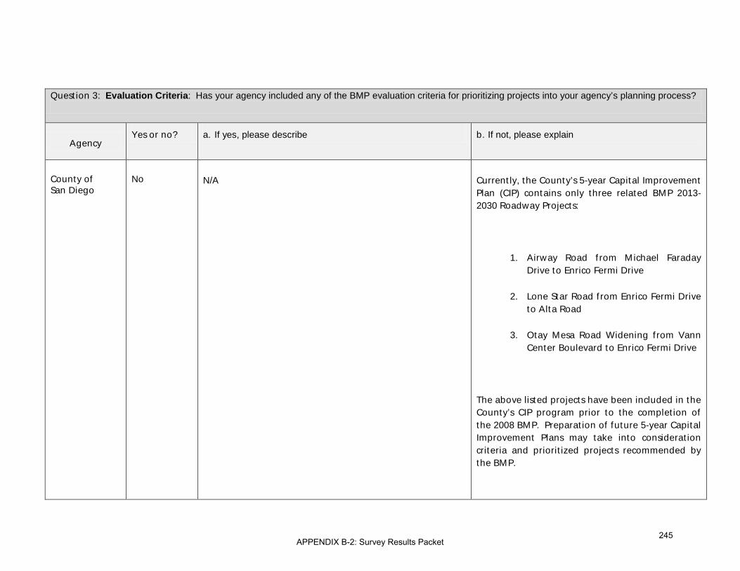
Question 3: Evaluation Criteria: Has your agency included any of the BMP evaluation criteria for prioritizing projects into your agency’s planning process?
Agency Yes or no? a. If yes, please describe b. If not, please explain
County of San Diego
No N/A
Currently, the County’s 5-year Capital Improvement Plan (CIP) contains only three related BMP 2013-2030 Roadway Projects:
1. Airway Road from Michael Faraday Drive to Enrico Fermi Drive
2. Lone Star Road from Enrico Fermi Drive to Alta Road
3. Otay Mesa Road Widening from Vann Center Boulevard to Enrico Fermi Drive
The above listed projects have been included in the County’s CIP program prior to the completion of the 2008 BMP. Preparation of future 5-year Capital Improvement Plans may take into consideration criteria and prioritized projects recommended by the BMP.
APPENDIX B-2: Survey Results Packet245

Question 3: Evaluation Criteria: Has your agency included any of the BMP evaluation criteria for prioritizing projects into your agency’s planning process?
Agency Yes or no? a. If yes, please describe b. If not, please explain
City of Chula Vista
No - See response to 1b.
City of Imperial Beach
No - same as 1b
City of National City
Yes Travel demand, congestion, project performance, readiness and regional benefit
-
City of San Diego
Yes Since these facilities carry a regional function, the City has been coordinating with SANDAG and Caltrans on prioritization under different programs.
-
SRE
Consulate of Mexico in San Diego
No - The Consulate General doesn’t have the responsibility to conduct planning or financing activities, these are solely functions of the Secretariat of Foreign Affairs.
APPENDIX B-2: Survey Results Packet246

Question 3: Evaluation Criteria: Has your agency included any of the BMP evaluation criteria for prioritizing projects into your agency’s planning process?
Agency Yes or no? a. If yes, please describe b. If not, please explain
Secretaría de Comunicaciones y Transporte (SCT)
Yes Annual Average Daily Traffic, Level of Service, capacity, etc.
-
General Customs Administration
(Administración General de Aduanas)
México D.F.
Yes Border wait times and service time to cross checkpoints -
General Customs Administration
(Administración General de Aduanas)
Tijuana B.C.
APPENDIX B-2: Survey Results Packet247

Question 3: Evaluation Criteria: Has your agency included any of the BMP evaluation criteria for prioritizing projects into your agency’s planning process?
Agency Yes or no? a. If yes, please describe b. If not, please explain
Secretariat of Social Development
(Secretaría de Desarrollo Social or (SEDESOL)
No - Same as question number two.
Institute of Administration and Estimates of National Real Estate
(INDAABIN)
Office of the Governor of Baja California
No - It was not included since the Secretary’s Project Management Division has its own criteria
Secretariat of Infrastructure and Urban Development (SIDUE)
No - It was not included since the Secretary’s Project Management Division has its own criteria
APPENDIX B-2: Survey Results Packet248

Question 3: Evaluation Criteria: Has your agency included any of the BMP evaluation criteria for prioritizing projects into your agency’s planning process?
Agency Yes or no? a. If yes, please describe b. If not, please explain
Instituto Municipal de Planeación de Tijuana (IMPLAN)
- - -
Municipality of Mexicali
No - -
Municipality of Rosarito
Municipality of Tecate
No - No, we are just recently getting familiar with this document; we have not employed it at that level yet.
Municipality of Tijuana
APPENDIX B-2: Survey Results Packet249

Question 4: Funding Requests: Has your agency used the 2008 BMP to obtain funding for specific projects?
Agency Yes or no? a. If yes, please describe b. If not, please explain
U.S. Department of State (DOS)
No - N/A
U.S. Customs and Border Protection (CBP)
Yes San Ysidro, CA Phase I Construction. We are also working closely with the project proponents on advancing the Otay Mesa East LPOE project, currently in development.
-
U.S. General Services Administration (GSA)
No - See above [response to question 2b]
U.S. Federal Highway Administration (FHWA)
No - FHWA does not obtain funding for specific projects. The Federal-aid program is managed by the state or local agencies. We have used the information the California/Baja California Master plan to advocate for the projects in Binational meetings such as in the 21st Century Border IPC meetings.
APPENDIX B-2: Survey Results Packet250

Question 4: Funding Requests: Has your agency used the 2008 BMP to obtain funding for specific projects?
Agency Yes or no? a. If yes, please describe b. If not, please explain
California Department of Transportation (Caltrans)
Yes TIGER I funds are being used to complete the final interchange linking SR-905 with I-805. The TIGER grant ($20,200,000.00) is four percent of the total $449 million cost of completing SR-905.
Caltrans submitted additional requests for TIGER funding indentified in BMP projects for Port of Entry and border transportation projects. Among these projects are the Cesar Chavez Blvd. / Calexico-West Port of Entry (POE) Congestion Improvements, the Imperial Avenue Interchange Reconstruction and Imperial Avenue extension to McCabe Road, the San Ysidro Intermodal Transportation Center planning study, and the new SR-11 connector to SR-905 (part of the Border Infrastructure Improvements).
As part of the SR-11/Otay Mesa East project development, FHWA awarded SANDAG a grant to conduct an Intelligent Transportation Systems (ITS) Pre-Deployment Study for the project. This study will create a Concept of Operations or blueprint for what ITS strategies should be implemented at the new border crossing.
-
Imperial County Transportation Commission (ICTC)
Yes See items 1a and 2a. -
APPENDIX B-2: Survey Results Packet251

Question 4: Funding Requests: Has your agency used the 2008 BMP to obtain funding for specific projects?
Agency Yes or no? a. If yes, please describe b. If not, please explain
San Diego Association of Governments (SANDAG)
No - -
Southern California Association of Governments (SCAG)
No - Funding requests would be initiated by Imperial County.
County of Imperial
Yes The County of Imperial has used the 2008 California-Baja California BMP to seek funding for the Calexico West Land POE and numerous local roads and highways.
-
City of Calexico No - See Section 1.b)
City of El Centro Yes We have incorporated reference to projects listed in the plan to grant solicitation
-
APPENDIX B-2: Survey Results Packet252

Question 4: Funding Requests: Has your agency used the 2008 BMP to obtain funding for specific projects?
Agency Yes or no? a. If yes, please describe b. If not, please explain
City of Holtville No - The City of Holtville will use the 2008 BMP to obtain funding for regional transportation and infrastructure projects.
County of San Diego
No N/A No funding has been obtained related to BMP projects within the County’s jurisdiction.
City of Chula Vista
No - See response to 1b.
City of Imperial Beach
No - Same as 1b
City of National City
No - See response to Question #1.
City of San Diego Yes See response to 3a-. -
SRE
APPENDIX B-2: Survey Results Packet253

Question 4: Funding Requests: Has your agency used the 2008 BMP to obtain funding for specific projects?
Agency Yes or no? a. If yes, please describe b. If not, please explain
Consulate of Mexico in San Diego
No - The Consulate General doesn’t have the responsibility to conduct planning or financing activities.
Secretaría de Comunicaciones y Transporte (SCT)
Yes Concessions and Public Private Partnerships -
General Customs Administration
(Administración General de Aduanas)
México D.F.
No - Projects are planned and funding is with our own resources
General Customs Administration
(Administración General de Aduanas)
APPENDIX B-2: Survey Results Packet254

Question 4: Funding Requests: Has your agency used the 2008 BMP to obtain funding for specific projects?
Agency Yes or no? a. If yes, please describe b. If not, please explain
Tijuana B.C.
Secretariat of Social Development
(Secretaría de Desarrollo Social or (SEDESOL)
No - Due to the nature of the projects that our agency promotes (SEDESOL) don’t have anything to do with any specific transportation nor Port of Entry related projects.
Institute of Administration and Estimates of National Real Estate
(INDAABIN)
Office of the Governor of Baja California
Yes At the Investment Unit of the SHCP, for complementary projects at Baja California border crossings, land acquisition, and for road access projects to the ports of entry.
-
APPENDIX B-2: Survey Results Packet255

Question 4: Funding Requests: Has your agency used the 2008 BMP to obtain funding for specific projects?
Agency Yes or no? a. If yes, please describe b. If not, please explain
Secretariat of Infrastructure and Urban Development (SIDUE)
Yes At the Investment Unit of the SHCP, for complementary projects at Baja California border crossings, land acquisition, and for road access projects to the ports of entry.
-
Instituto Municipal de Planeación de Tijuana (IMPLAN)
- - -
Municipality of Mexicali
No - The consideration of border issues is exercised through the State and Federal governments.
Municipality of Rosarito
Municipality of Tecate
Yes Yes, in the project to enable “Avenida México” as a fiscal state and federal level channel.
-
Municipality of Tijuana
APPENDIX B-2: Survey Results Packet256

Question 5: Please describe any other ways your agency has used the 2008 BMP.
Agency Response
U.S. Department of State (DOS)
The Department of State is a strong federal advocate for binational regional master plans, and has used the 2008 BMP repeatedly as an example of what needs to be (and finally is being) done all along the border. Without the example of the CA-Baja plan to explain the use and success of the concept, we would not have been able to make so much progress so quickly.
U.S. Customs and Border Protection (CBP)
CBP has used the 2008 California-Baja California BMP to substantiate its investment choices in response to internal and external inquiries.
U.S. General Services Administration (GSA)
-
U.S. Federal Highway Administration (FHWA)
As stated earlier, FHWA is using this BMP as examples for other border regions to use a guide for the development of the Regional BMP.
APPENDIX B-2: Survey Results Packet257
Question 5: Please describe any other ways your agency has used the 2008 BMP.
Agency Response
California Department of Transportation (Caltrans)
The 2008 BMP was utilized to provide recommendations at the Border Governors Conference for advancing transportation needs throughout the U.S./Mexico border area. In addition, information from the BMP was included in the U.S.-Mexico Binational Group on Bridges and Border Crossings for the purpose of supporting the Otay Mesa East / State Route 11 Port of Entry project.
The Departments of Transportation in California, Nevada, Arizona, and Utah – members of the Interstate 15 Corridor Alliance – agreed that the Otay Mesa East border crossing and related connectors are high-priority, “early action projects” needed to make the I-15 more successful and efficient. A Corridor System Master Plan (draft) describes how improved border mobility depends on the I-15.
Imperial County Transportation Commission (ICTC)
Generally, we have used it to promote the advancement to prioritized projects within our region.
San Diego Association of Governments (SANDAG)
The 2008 BMP has been an important education tool for border stakeholders, including policy makers. Updates on the BMP during its development provided by staff helped keep policy makers informed about work happening in the border region in addition to providing a framework to discuss borders issues and projects.
The 2008 BMP has also served to generate discussions about border issues and projects. The project rankings included in the BMP generated dialogue about effective implementation of border infrastructure and regional priorities.
Images, maps, and other information contained in the 2008 BMP have been used in various presentations as informational material regarding the border region.
APPENDIX B-2: Survey Results Packet258

Question 5: Please describe any other ways your agency has used the 2008 BMP.
Agency Response
Southern California Association of Governments (SCAG)
-
County of Imperial Data provided within the 2008 California-Baja California BMP has been used by the County of Imperial in various grant applications, recommendations, etc.
City of Calexico -
City of El Centro -
City of Holtville -
County of San Diego
N/A
City of Chula Vista i. As a general reference in determining what is going on at the border and what is planned at the border.
APPENDIX B-2: Survey Results Packet259

Question 5: Please describe any other ways your agency has used the 2008 BMP.
Agency Response
City of Imperial Beach
-
City of National City
None.
City of San Diego Indirectly, the City has been coordinating with SANDAG and Caltrans on the planning, design and implementation of regional projects identified in the BMP.
SRE
Consulate of Mexico in San Diego
-
Secretaría de Comunicaciones y Transporte (SCT)
To promote the development of similar exercises in other important border areas
APPENDIX B-2: Survey Results Packet260

Question 5: Please describe any other ways your agency has used the 2008 BMP.
Agency Response
General Customs Administration
(Administración General de Aduanas)
México D.F.
Mainly to promote projects and program priority projects that could provide benefits for both countries.
General Customs Administration
(Administración General de Aduanas)
Tijuana B.C.
Secretariat of Social Development
(Secretaría de Desarrollo Social or (SEDESOL)
As was mentioned above in question number one.
APPENDIX B-2: Survey Results Packet261

Question 5: Please describe any other ways your agency has used the 2008 BMP.
Agency Response
Institute of Administration and Estimates of National Real Estate
(INDAABIN)
Office of the Governor of Baja California
-
Secretariat of Infrastructure and Urban Development (SIDUE)
-
Institúto Municipal de Planeación de Tijuana (IMPLAN)
-
Municipality of Mexicali
-
APPENDIX B-2: Survey Results Packet262
Question 5: Please describe any other ways your agency has used the 2008 BMP.
Agency Response
Municipality of Rosarito
Municipality of Tecate
It has not been used in other ways; however, we expect to use it as an input because it is a document of international importance.
Municipality of Tijuana
APPENDIX B-2: Survey Results Packet263

Question 6: If your agency has not used the 2008 BMP, please describe why not.
Agency Response
U.S. Department of State (DOS)
-
U.S. Customs and Border Protection (CBP)
-
U.S. General Services Administration (GSA)
Again, most of the projects GSA is working on in the San Diego region were already in process when the 2008 BMP was released.
U.S. Federal Highway Administration (FHWA)
-
California Department of Transportation (Caltrans)
-
Imperial County Transportation Commission (ICTC)
-
APPENDIX B-2: Survey Results Packet264

Question 6: If your agency has not used the 2008 BMP, please describe why not.
Agency Response
San Diego Association of Governments (SANDAG)
N/A
Southern California Association of Governments (SCAG)
-
County of Imperial -
City of Calexico
2008 California-Baja California BMP has not being taken in consideration because the staff that was involved with this 2008 study no longer works in the city and said report final report never made to this office. But for future reference this report may be use full in current grant applications that the city is applying.
City of El Centro -
City of Holtville -
APPENDIX B-2: Survey Results Packet265

Question 6: If your agency has not used the 2008 BMP, please describe why not.
Agency Response
County of San Diego Current documents and projects which the County has approved or started had begun development prior to the implementation of the 2008 BMP. Finding and Recommendations in the updated BMPs will be incorporated into future documents and projects when they are next updated.
City of Chula Vista i See response to 1b.
City of Imperial Beach The existence of the BMP wasn’t know or well known to people in our agency. See 1b.
City of National City See response to Question #1.
City of San Diego -
SRE
Consulate of Mexico in San Diego
The Consulate General doesn’t have this responsibility.
APPENDIX B-2: Survey Results Packet266

Question 6: If your agency has not used the 2008 BMP, please describe why not.
Agency Response
Secretaría de Comunicaciones y Transporte (SCT)
-
General Customs Administration
(Administración General de Aduanas)
México D.F.
-
General Customs Administration
(Administración General de Aduanas)
Tijuana B.C.
APPENDIX B-2: Survey Results Packet267

Question 6: If your agency has not used the 2008 BMP, please describe why not.
Agency Response
Secretariat of Social Development
(Secretaría de Desarrollo Social or (SEDESOL)
To answer this question please see to question number four.
Institute of Administration and Estimates of National Real Estate
(INDAABIN)
Office of the Governor of Baja California
-
Secretariat of Infrastructure and Urban Development (SIDUE)
-
APPENDIX B-2: Survey Results Packet268

Question 6: If your agency has not used the 2008 BMP, please describe why not.
Agency Response
Instituto Municipal de Planeación de Tijuana (IMPLAN)
-
Municipality of Mexicali
We channel our border issues through the State and Federal governments
Municipality of Rosarito
Municipality of Tecate
-
Municipality of Tijuana
APPENDIX B-2: Survey Results Packet269

Question 9: How would your agency most likely use the 2011/12 BMP Update? .
Agency Response
U.S. Department of State (DOS)
The update will be a reference tool given substantial weight during consideration of Presidential Permit applications for all projects in the region.
U.S. Customs and Border Protection (CBP)
CBP will use the 2011/12 BMP Update in its planning process to identify LPOE capital investment priorities and ensure the agency’s available resources are directed to the area(s) of greatest need in the region.
U.S. General Services Administration (GSA)
As a planning tool to assist us in allocating / prioritizing limited resources for our LPOE projects.
U.S. Federal Highway Administration (FHWA)
Federal Highway Administration uses the BMP as a planning tool for binational coordination of border
projects and regional future needs. The BMP provides a foundation for state and local planning
organizations for implementation of resources.
California Department of Transportation (Caltrans)
The Caltrans District 11 Planning Division may utilize information from the 2011/12 BMP in our core System Planning products mentioned previously (TCCRs, TSDP, and DSMP). In addition, the BMP information may be used for Goods Movement/Freight Planning, including the development of the Goods Movement Action Plan (GMAP). BMP information could also be used for Geographic Information Systems (GIS) coverages in the border area, as well as Transportation Modeling and Forecasting. Lastly, BMP information could be included in California Business, Transportation, and Housing Agency reports to the California Governor’s office, and also provided to third parties and external transportation partners.
APPENDIX B-2: Survey Results Packet270

Question 9: How would your agency most likely use the 2011/12 BMP Update? .
Agency Response
Imperial County Transportation Commission (ICTC)
Similar to past actions identified in items 1a and 2a.
San Diego Association of Governments (SANDAG)
SANDAG would likely continue to use the BMP update as a reference for information about border projects. Recommendations would be evaluated for future implementation in the regional planning process.
Southern California Association of Governments (SCAG)
To the extent possible after the BMP is published, to incorporate aspects of it into the 2016 Regional Transportation Plan
County of Imperial The County of Imperial would use the update to continue the current efforts of seeking various funding opportunities.
City of Calexico City of Calexico being a border city using the 201/12 BMP will be used full instrument for future planning within the city. This study will help the city project better planning for transportation, growth projection, integration with other border related infrastructure.
City of El Centro To continue efforts to locate funding sources for projects in the list.
APPENDIX B-2: Survey Results Packet271

Question 9: How would your agency most likely use the 2011/12 BMP Update? .
Agency Response
City of Holtville To assist in infrastructure planning.
County of San Diego The BMP Update would likely be used as a reference document in prioritizing future projects and/or in planning documents. Funding/grant requests for projects in the region may highlight projects prioritized in the BMP.
City of Chula Vista i. Evaluate regional funding priorities in future RTP's.
ii. Awareness of planned improvements ancl timing for POE and transportation facilities along the border.
iii. Evaluation of cross border commute and commerce traffic volumes on local roadways/infrastructure and local economic effects
City of Imperial Beach
To work with other stakeholders to ensure that traffic flows aren’t negatively by affected on I-5 north by POE operations.
City of National City Obtain funding for specific transportation projects.
Use analysis and recommendations from the 2011/12 BMP Update to promote transportation projects that improve traffic congestion and stimulate the local and regional economy
APPENDIX B-2: Survey Results Packet272
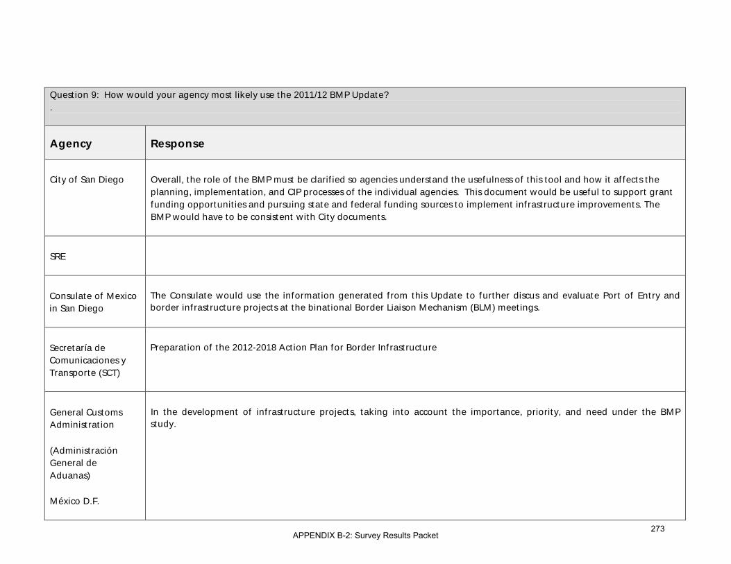
Question 9: How would your agency most likely use the 2011/12 BMP Update? .
Agency Response
City of San Diego Overall, the role of the BMP must be clarified so agencies understand the usefulness of this tool and how it affects the planning, implementation, and CIP processes of the individual agencies. This document would be useful to support grant funding opportunities and pursuing state and federal funding sources to implement infrastructure improvements. The BMP would have to be consistent with City documents.
SRE
Consulate of Mexico in San Diego
The Consulate would use the information generated from this Update to further discus and evaluate Port of Entry and border infrastructure projects at the binational Border Liaison Mechanism (BLM) meetings.
Secretaría de Comunicaciones y Transporte (SCT)
Preparation of the 2012-2018 Action Plan for Border Infrastructure
General Customs Administration
(Administración General de Aduanas)
México D.F.
In the development of infrastructure projects, taking into account the importance, priority, and need under the BMP study.
APPENDIX B-2: Survey Results Packet273

Question 9: How would your agency most likely use the 2011/12 BMP Update? .
Agency Response
General Customs Administration
(Administración General de Aduanas)
Tijuana B.C.
Secretariat of Social Development
(Secretaría de Desarrollo Social or (SEDESOL)
Especially the addition of infrastructure projects for non-motorized modes of cross-border transportation is an area of great interest to our agency because of their high social impacts. It is also essential that the development of the different modes of transportation and border infrastructure is closely linked to the regional and urban planning process.
Institute of Administration and Estimates of National Real Estate
(INDAABIN)
APPENDIX B-2: Survey Results Packet274

Question 9: How would your agency most likely use the 2011/12 BMP Update? .
Agency Response
Office of the Governor of Baja California
The State responsibility towards the national government in terms of requesting funds and promoting projects has not finished; that is why I think is paramount the Border Master Plan Update. Currently not all the funds have been identified and there is uncertainty about the status of projects. We also need to consider the current development of other Master Plans along the Border; I believe that we have an advantage over other states that must be seized.
Secretariat of Infrastructure and Urban Development (SIDUE)
The State responsibility towards the national government in terms of requesting funds and promoting projects has not finished; that is why I think is paramount the Border Master Plan Update. Currently not all the funds have been identified and there is uncertainty about the status of projects. We also need to consider the current development of other Master Plans along the Border; I believe that we have an advantage over other states that must be seized.
Instituto Municipal de Planeación de Tijuana (IMPLAN)
-
Municipality of Mexicali
In the information management for the current and the planned long- term urban area.
Municipality of Rosarito
APPENDIX B-2: Survey Results Packet275
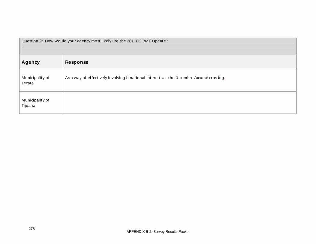
Question 9: How would your agency most likely use the 2011/12 BMP Update? .
Agency Response
Municipality of Tecate
As a way of effectively involving binational interests at the-Jacumba- Jacumé crossing.
Municipality of Tijuana
APPENDIX B-2: Survey Results Packet276

Question 10: Please share specific ideas your agency would like to see incorporated as part of the BMP Update. (Please limit to one page and include uses for your ideas and types of related information/data your agency could provide.) .
Agency Response
U.S. Department of State (DOS)
-
U.S. Customs and Border Protection (CBP)
CBP’s interest is to ensure the 2011/12 Update captures the latest socioeconomic developments in the region to enable the BMP to continue to serve as an objective, defensible mechanism for LPOE project prioritization that integrates the regional planning expertise and bilateral, multi-stakeholder input.
U.S. General Services Administration (GSA)
• Listing and prioritization of small cost high impact projects to improve the LPOEs.
• A similar list of traffic and transit projects that could improve the efficiency of LPOEs
U.S. Federal Highway Administration (FHWA)
A clear understanding of the cause and effect proposed border expansions will have on existing and proposed facilities. In other words, ensure our investment in proposed expansions yields the highest benefit to the travelling public.
APPENDIX B-2: Survey Results Packet277

Question 10: Please share specific ideas your agency would like to see incorporated as part of the BMP Update. (Please limit to one page and include uses for your ideas and types of related information/data your agency could provide.) .
Agency Response
California Department of Transportation (Caltrans)
Above all, the BMP needs to focus on developing strategies for innovative financing of transportation projects. The OME tolling is going to be a great experiment that should be followed closely for viable funding. The border region has an opportunity to take advantage of its unique location that will deliver benefits to both sides if planned cooperatively and diplomatically. Part of the BMP needs to explore how to overcome jurisdictional and other obstacles inherent in border projects. The stakeholders must need to reach some agreement on incentives and penalties for deploying BMP-identified projects.
Coordination with the new statewide “California Interregional Blueprint” transportation planning effort could be the best way to ensure that border priorities have been properly recognized at the State level.
Cross-border linkage to the State’s intercity passenger rail and bus network could be further explored.
A commuter ferry and other types of water transportation for people and goods between San Diego and Baja California might be another way to reduce congestion at land ports.
Imperial County Transportation Commission (ICTC)
No suggestions at this time.
San Diego Association of Governments (SANDAG)
Please see priorities shown in section 2.b).
APPENDIX B-2: Survey Results Packet278
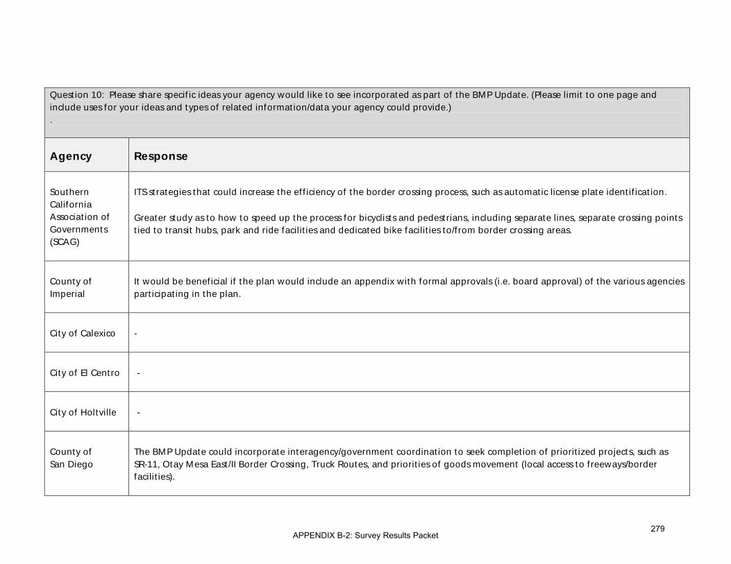
Question 10: Please share specific ideas your agency would like to see incorporated as part of the BMP Update. (Please limit to one page and include uses for your ideas and types of related information/data your agency could provide.) .
Agency Response
Southern California Association of Governments (SCAG)
ITS strategies that could increase the efficiency of the border crossing process, such as automatic license plate identification.
Greater study as to how to speed up the process for bicyclists and pedestrians, including separate lines, separate crossing points tied to transit hubs, park and ride facilities and dedicated bike facilities to/from border crossing areas.
County of Imperial
It would be beneficial if the plan would include an appendix with formal approvals (i.e. board approval) of the various agencies participating in the plan.
City of Calexico -
City of El Centro -
City of Holtville -
County of San Diego
The BMP Update could incorporate interagency/government coordination to seek completion of prioritized projects, such as SR-11, Otay Mesa East/II Border Crossing, Truck Routes, and priorities of goods movement (local access to freeways/border facilities).
APPENDIX B-2: Survey Results Packet279

Question 10: Please share specific ideas your agency would like to see incorporated as part of the BMP Update. (Please limit to one page and include uses for your ideas and types of related information/data your agency could provide.) .
Agency Response
City of Chula Vista
i. Next generation of document should clarify if border crossing facility expansions are intended to increase flow and reduce delays or are they intended to increase security screening capacities, or both.
ii. Include a future section that clearly explains the role and function of the BMP and when/how the BMP is relevant to and useful in local planning and infrastructure activities. This should include any relations to supporting various local, regional, state and lor federal funding/grant requests.
City of Imperial Beach
a. Ensure rapid travel through POEs
b. Consider entry at Border State Park as a POE
c. At the POEs promote tourism of sites and facilities in nearby communities.
d. Promote different ways to cross the border—walk, bike, extend rail lines,
City of National City
Forecasts on traffic, goods movements, employment and economic stimulus as a result of the proposed POE, interchange, roadway, transit and freight projects.
Benefits realized from completion of past border-related projects.
City of San Diego
The City could offer the Climate Action Plan and its EIR and technical studies that are scheduled to be completed in 2012.
APPENDIX B-2: Survey Results Packet280

Question 10: Please share specific ideas your agency would like to see incorporated as part of the BMP Update. (Please limit to one page and include uses for your ideas and types of related information/data your agency could provide.) .
Agency Response
SRE
Consulate of Mexico in San Diego
• Online web-portal to provide updated information on border projects and efforts.
• Review and update existing evaluation criteria for Port of Entry projects.
• Include a dialogue on short- or medium-term operations improvements to reduce wait times at both sides of the border (e.g., Increase the use of FAST, express lanes).
Secretaría de Comunicaciones y Transporte (SCT)
1. Redesign a systematic approach focusing in Ports of Entry.
2. Complement Intermodal Transit Center Studies and Incorporate Systems and Traffic Management Centers.
General Customs Administration
(Administración General de Aduanas)
México D.F.
Short time project prioritization.
APPENDIX B-2: Survey Results Packet281
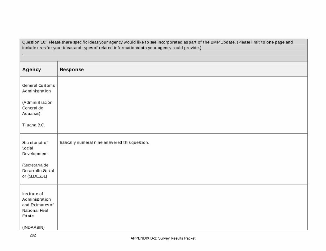
Question 10: Please share specific ideas your agency would like to see incorporated as part of the BMP Update. (Please limit to one page and include uses for your ideas and types of related information/data your agency could provide.) .
Agency Response
General Customs Administration
(Administración General de Aduanas)
Tijuana B.C.
Secretariat of Social Development
(Secretaría de Desarrollo Social or (SEDESOL)
Basically numeral nine answered this question.
Institute of Administration and Estimates of National Real Estate
(INDAABIN)
APPENDIX B-2: Survey Results Packet282

Question 10: Please share specific ideas your agency would like to see incorporated as part of the BMP Update. (Please limit to one page and include uses for your ideas and types of related information/data your agency could provide.) .
Agency Response
Office of the Governor of Baja California
The recommendations and opinions we have issued have been already taken into account, such as to include short-term actions, and the projects that already ground-braked that were included in the 2008 Plan, and the impacts that these will have on other projects.
Secretariat of Infrastructure and Urban Development (SIDUE)
The recommendations and opinions we have issued have been already taken into account, such as to include short-term actions, and the projects that already ground-braked that were included in the 2008 Plan, and the impacts that these will have on other projects.
Instituto Municipal de Planeación de Tijuana (IMPLAN)
-
Municipality of Mexicali
See attachment.
Municipality of Rosarito
APPENDIX B-2: Survey Results Packet283

Question 10: Please share specific ideas your agency would like to see incorporated as part of the BMP Update. (Please limit to one page and include uses for your ideas and types of related information/data your agency could provide.) .
Agency Response
Municipality of Tecate
a. Currently the crossings at the metropolitan region comprising the municipalities of Rosarito, Tecate, and Tijuana have focus in the Tijuana region. However, due to the growth of the economy in Ensenada and the metropolitan region it is necessary to provide a strategic crossing at Jacumba-Jacume. A crossing port that has been discussed to for at least six years due to advantages for both sides of the border due to its proximity in the U.S. side to Interstate 8 thus quickly and efficiently connecting it into the California highway network. Also, south of the border there is an excellent link to the federal free highway number 2 and the toll highway Mexicali-Tijuana, in addition to a future road that will eventually link these highways with the Ensenada-San Felipe highway. Moreover, and in to reduce traffic jams that is caused by the concentration of border crossings at the Otay area this new crossing (which previously was in use as an pedestrian port) could be an important trigger for the creation of a development center for Jacumé and El Hongo; region with the necessary resources for the development of wind energy and who has access to water supply from the Rio Colorado-Tijuana aqueduct.
b. Another project of great interest to the municipality of Tecate is the rehabilitation of the customs border crossing at the railway line that crosses from Tijuana into California by Joe Bill. This is an asset, which has not been properly used to facilitate rail freight border crossings. Currently, is a route that has not yet completed its rehabilitation to receive railroad cars adequately; these necessary improvements will efficiently link us to the United States rail network.
Municipality of Tijuana
APPENDIX B-2: Survey Results Packet284

Question 11: Please describe any new issues and/or trends your agency would like to be considered in this BMP Update. Please let us know how you think these issues may impact this BMP Update. Some examples include new policy and economic issues, legislation, and infrastructure completed and planned since the 2008 BMP.
Agency Response
U.S. Department of State (DOS)
Review of the inspection and transportation infrastructure needed to facilitate southbound inspections.
U.S. Customs and Border Protection (CBP)
-
U.S. General Services Administration (GSA)
Given the limited resources available to our projects, we think the BMP could provide us with a good tool for helping the GSA to prioritize our limited small dollar capital projects by showing how they can relate to improvements made to area transit and roadway improvement projects.
U.S. Federal Highway Administration (FHWA)
Federal Motor Carrier Safety Administration is currently working to certify Mexican carriers in the United States. How will this affect border crossings and regional border transportation infrastructure?
California Department of Transportation (Caltrans)
One issue that greatly impacts travelers is unanticipated delays incurred at checkpoints on our freeways. Unpredictability of inspections at peak travel times cause avoidable congestion well beyond the border. Better consensus and communication among agency stakeholders and the traveling public could result in fewer unnecessary stops, as well as reduce the economic impact for commerce on heavily-used routes.
The State has new policies and mandates on planning from greenhouse gas emissions to “complete streets” and “smart growth” among others for consideration.
Case studies of “best practices” from other metro and rural border crossings are needed.
APPENDIX B-2: Survey Results Packet285

Question 11: Please describe any new issues and/or trends your agency would like to be considered in this BMP Update. Please let us know how you think these issues may impact this BMP Update. Some examples include new policy and economic issues, legislation, and infrastructure completed and planned since the 2008 BMP.
Agency Response
Imperial County Transportation Commission (ICTC)
For POE evaluation criteria I would like some consideration for separating operational improvements and major POE expansions
San Diego Association of Governments (SANDAG)
Consider the evaluation of new models to finance and deliver border transportation infrastructure.
Southern California Association of Governments (SCAG)
I can’t think of anything.
County of Imperial
APPENDIX B-2: Survey Results Packet286

Question 11: Please describe any new issues and/or trends your agency would like to be considered in this BMP Update. Please let us know how you think these issues may impact this BMP Update. Some examples include new policy and economic issues, legislation, and infrastructure completed and planned since the 2008 BMP.
Agency Response
City of Calexico The city of Calexico is currently working with a consultant to in the preliminary engineering of Cesar Chavez Boulevard to accommodate the proposed new West POE. City anticipates that environmental clearance & plans and specs will be finish by the 4th quarter 2012. What we have encounter in the early stage of this project that there was lack of communication with GSA engineering consultant and the city of Calexico. GSA engineering consultant never approach the city of Calexico to see in what ways their design could accommodate the city needs with these new POE. The city knowing we needed to be prepare for when the new POE was to open the city proceeded with design on Cesar Chavez Boulevard preliminary design. After first coordination meeting with GSA we encounter some problems with their design at the intersection of Cesar Chavez Boulevard & 2nd street that will not work effectively for city. GSA claims their plans where 90 percent done and it will be impossible to change the plans when city still needed additional right-of-way, intersection alignment with their facility to accommodate the new west POE building. Currently the city has request additional right-of-way and consideration to realign one of their entrances so Cesar Chavez & 2nd street operation run more efficient. So BMP should well address the importance of coordination with all other entities especially when one facility might impact a city.
City of El Centro
City of Holtville
County of San Diego • Security at Border Crossings
• Environmental Mitigation in Border Area
APPENDIX B-2: Survey Results Packet287
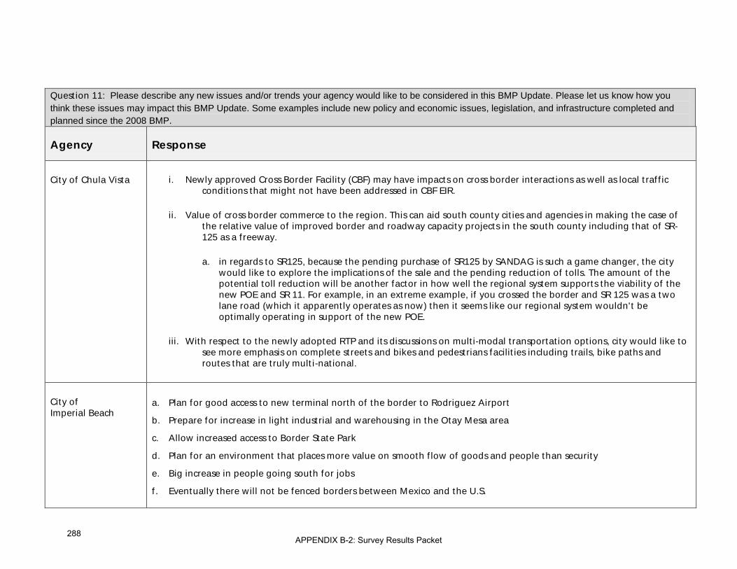
Question 11: Please describe any new issues and/or trends your agency would like to be considered in this BMP Update. Please let us know how you think these issues may impact this BMP Update. Some examples include new policy and economic issues, legislation, and infrastructure completed and planned since the 2008 BMP.
Agency Response
City of Chula Vista i. Newly approved Cross Border Facility (CBF) may have impacts on cross border interactions as well as local traffic conditions that might not have been addressed in CBF EIR.
ii. Value of cross border commerce to the region. This can aid south county cities and agencies in making the case of the relative value of improved border and roadway capacity projects in the south county including that of SR-125 as a freeway.
a. in regards to SR125, because the pending purchase of SR125 by SANDAG is such a game changer, the city would like to explore the implications of the sale and the pending reduction of tolls. The amount of the potential toll reduction will be another factor in how well the regional system supports the viability of the new POE and SR 11. For example, in an extreme example, if you crossed the border and SR 125 was a two lane road (which it apparently operates as now) then it seems like our regional system wouldn't be optimally operating in support of the new POE.
iii. With respect to the newly adopted RTP and its discussions on multi-modal transportation options, city would like to see more emphasis on complete streets and bikes and pedestrians facilities including trails, bike paths and routes that are truly multi-national.
City of Imperial Beach
a. Plan for good access to new terminal north of the border to Rodriguez Airport
b. Prepare for increase in light industrial and warehousing in the Otay Mesa area
c. Allow increased access to Border State Park
d. Plan for an environment that places more value on smooth flow of goods and people than security
e. Big increase in people going south for jobs
f. Eventually there will not be fenced borders between Mexico and the U.S.
APPENDIX B-2: Survey Results Packet288

Question 11: Please describe any new issues and/or trends your agency would like to be considered in this BMP Update. Please let us know how you think these issues may impact this BMP Update. Some examples include new policy and economic issues, legislation, and infrastructure completed and planned since the 2008 BMP.
Agency Response
City of National City See response to Question #10.
City of San Diego • Address GHG and the reduction of short and long term impacts
• Consider land use analysis in proximity to the ports of entry
• Address fiscal analysis, funding schedule and phased implementation
• Address mitigation at the community level of the regional impacts
SRE
Consulate of Mexico in San Diego
The Consulate General shares the opinion that a central aspect to consider in updating the BMP is the expansion project of the Port of Entry in San Ysidro and the corresponding connection routes to the Port of El Chaparral that Mexico is contemplating in the short term. To the extent that there is no secured funding to complete Phases 2 and 3 in the U.S. and to finish this project could continue for years, it is necessary to evaluate the impact of this delay will have on wait times to cross the border into Mexico. To the extent that the San Ysidro Port of Entry is the largest in the United States-Mexico border, delaying the expansion project will impact sensitive investments on border crossings and transportation infrastructure within a port of entry system in a metropolitan area that is part of the scope of the BMP.
APPENDIX B-2: Survey Results Packet289

Question 11: Please describe any new issues and/or trends your agency would like to be considered in this BMP Update. Please let us know how you think these issues may impact this BMP Update. Some examples include new policy and economic issues, legislation, and infrastructure completed and planned since the 2008 BMP.
Agency Response
Secretaría de Comunicaciones y Transporte (SCT)
• Integrate customs and border protection operations and border crossings wait times
• Innovative and dynamic toll systems
• Creation of a system of “Green” and sustainable POE’s
• Private financing for projects
• Social responsibility of infrastructure projects
General Customs Administration
(Administración General de Aduanas)
México D.F.
The use of technologies to enhance and expedite crossing times on both sides of the border.
General Customs Administration
(Administración General de Aduanas)
Tijuana B.C.
APPENDIX B-2: Survey Results Packet290

Question 11: Please describe any new issues and/or trends your agency would like to be considered in this BMP Update. Please let us know how you think these issues may impact this BMP Update. Some examples include new policy and economic issues, legislation, and infrastructure completed and planned since the 2008 BMP.
Agency Response
Secretariat of Social Development
(Secretaría de Desarrollo Social or (SEDESOL)
-
Institute of Administration and Estimates of National Real Estate
(INDAABIN)
Office of the Governor of Baja California
Funding this study is a key topic to keep its usefulness prevails in time; maybe a cooperation agreements between the states strictly directed to the Border Master Plan that commits funding resources for future updates could be signed.
Secretariat of Infrastructure and Urban Development (SIDUE)
Funding this study is a key topic to keep its usefulness prevails in time; maybe a cooperation agreements between the states strictly directed to the Border Master Plan that commits funding resources for future updates could be signed.
APPENDIX B-2: Survey Results Packet291
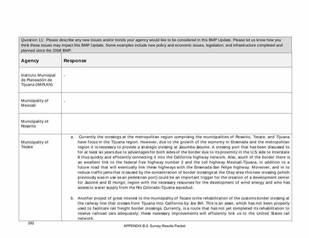
Question 11: Please describe any new issues and/or trends your agency would like to be considered in this BMP Update. Please let us know how you think these issues may impact this BMP Update. Some examples include new policy and economic issues, legislation, and infrastructure completed and planned since the 2008 BMP.
Agency Response
Instituto Municipal de Planeación de Tijuana (IMPLAN)
-
Municipality of Mexicali
-
Municipality of Rosarito
Municipality of Tecate
a. Currently the crossings at the metropolitan region comprising the municipalities of Rosarito, Tecate, and Tijuana have focus in the Tijuana region. However, due to the growth of the economy in Ensenada and the metropolitan region it is necessary to provide a strategic crossing at Jacumba-Jacume. A crossing port that has been discussed to for at least six years due to advantages for both sides of the border due to its proximity in the U.S. side to Interstate 8 thus quickly and efficiently connecting it into the California highway network. Also, south of the border there is an excellent link to the federal free highway number 2 and the toll highway Mexicali-Tijuana, in addition to a future road that will eventually link these highways with the Ensenada-San Felipe highway. Moreover, and in to reduce traffic jams that is caused by the concentration of border crossings at the Otay area this new crossing (which previously was in use as an pedestrian port) could be an important trigger for the creation of a development center for Jacumé and El Hongo; region with the necessary resources for the development of wind energy and who has access to water supply from the Rio Colorado-Tijuana aqueduct.
b. Another project of great interest to the municipality of Tecate is the rehabilitation of the customs border crossing at the railway line that crosses from Tijuana into California by Joe Bill. This is an asset, which has not been properly used to facilitate rail freight border crossings. Currently, is a route that has not yet completed its rehabilitation to receive railroad cars adequately; these necessary improvements will efficiently link us to the United States rail network.
APPENDIX B-2: Survey Results Packet292

Question 11: Please describe any new issues and/or trends your agency would like to be considered in this BMP Update. Please let us know how you think these issues may impact this BMP Update. Some examples include new policy and economic issues, legislation, and infrastructure completed and planned since the 2008 BMP.
Agency Response
Municipality of Tijuana
APPENDIX B-2: Survey Results Packet293

This page intentionally left blank
294

Appendix C: Border Crossing and Border Wait Time Data

This page intentionally left blank
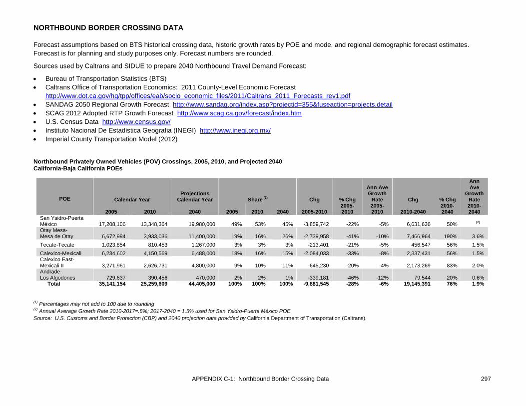
APPENDIX C-1: Northbound Border Crossing Data 297
NORTHBOUND BORDER CROSSING DATA
Forecast assumptions based on BTS historical crossing data, historic growth rates by POE and mode, and regional demographic forecast estimates. Forecast is for planning and study purposes only. Forecast numbers are rounded.
Sources used by Caltrans and SIDUE to prepare 2040 Northbound Travel Demand Forecast:
• Bureau of Transportation Statistics (BTS) • Caltrans Office of Transportation Economics: 2011 County-Level Economic Forecast
http://www.dot.ca.gov/hq/tpp/offices/eab/socio_economic_files/2011/Caltrans_2011_Forecasts_rev1.pdf • SANDAG 2050 Regional Growth Forecast http://www.sandag.org/index.asp?projectid=355&fuseaction=projects.detail • SCAG 2012 Adopted RTP Growth Forecast http://www.scag.ca.gov/forecast/index.htm • U.S. Census Data http://www.census.gov/ • Instituto Nacional De Estadistica Geografia (INEGI) http://www.inegi.org.mx/ • Imperial County Transportation Model (2012)
Northbound Privately Owned Vehicles (POV) Crossings, 2005, 2010, and Projected 2040 California-Baja California POEs
POE Calendar Year Projections
Calendar Year Share (1) Chg % Chg
Ann Ave Growth
Rate Chg % Chg
Ann Ave
Growth Rate
2005 2010 2040 2005 2010 2040 2005-2010 2005-2010
2005-2010 2010-2040
2010-2040
2010-2040
San Ysidro-Puerta México 17,208,106 13,348,364 19,980,000 49% 53% 45% -3,859,742 -22% -5% 6,631,636 50% (2) Otay Mesa- Mesa de Otay 6,672,994 3,933,036 11,400,000 19% 16% 26% -2,739,958 -41% -10% 7,466,964 190% 3.6% Tecate-Tecate 1,023,854 810,453 1,267,000 3% 3% 3% -213,401 -21% -5% 456,547 56% 1.5% Calexico-Mexicali 6,234,602 4,150,569 6,488,000 18% 16% 15% -2,084,033 -33% -8% 2,337,431 56% 1.5% Calexico East-Mexicali II 3,271,961 2,626,731 4,800,000 9% 10% 11% -645,230 -20% -4% 2,173,269 83% 2.0% Andrade- Los Algodones 729,637 390,456 470,000 2% 2% 1% -339,181 -46% -12% 79,544 20% 0.6% Total 35,141,154 25,259,609 44,405,000 100% 100% 100% -9,881,545 -28% -6% 19,145,391 76% 1.9%
(1) Percentages may not add to 100 due to rounding (2) Annual Average Growth Rate 2010-2017=.8%; 2017-2040 = 1.5% used for San Ysidro-Puerta México POE. Source: U.S. Customs and Border Protection (CBP) and 2040 projection data provided by California Department of Transportation (Caltrans).

298 APPENDIX C-1: Northbound Border Crossing Data
Northbound Bus Crossings, 2005, 2010, and Projected 2040 California-Baja California POEs
POE Calendar Year
Projections Calendar
Year Share (2) Chg % Chg Ann Ave
Growth Rate Chg % Chg
Ann Ave Growth
Rate
2005 2010 2040 (1) 2005 2010 2040 2005-2010 2005-2010 2005-2010
2010-2040
2010-2040
2010-2040
San Ysidro- Puerta México 105,930 70,548 119,000 72% 65% 65% -35,382 -33% -7.8% 48,452 69% 1.8% Otay Mesa- Mesa de Otay 39,203 34,630 58,300 26% 32% 32% -4,573 -12% -2% 23,670 68% 1.8% Tecate-Tecate 351 230 360 0% 0% 0% -121 -34% -8% 130 56% 1.5% Calexico-Mexicali 2,217 0 1,485 1% 0% 1% -2,217 -100% -100% 1,485 N/A N/A Calexico East- Mexicali II 284 1,897 1,815 0% 2% 1% 1,613 568% 46% -82 -4% -0.1% Andrade- Los Algodones 14 0 N/A 0% 0% N/A -14 -100% -100% N/A N/A N/A Total (2) 147,999 107,305 180,960 100% 100% 100% -40,694 -27% -6% 73,655 69% 1.75%
(1) Buses began primarily using Calexico East POE beginning in 2008. 2040 estimate assumes resumed bus crossing at Calexico West POE once modernization is complete. This could change depending on final design of POE. (2) Percentages may not add to 100 due to rounding Source: U.S. Customs and Border Protection (CBP) and 2040 projection data provided by California Department of Transportation (Caltrans).

APPENDIX C-1: Northbound Border Crossing Data 299
Northbound Pedestrian Crossings, 2005, 2010, and Projected 2040 California-Baja California POEs
POE Calendar Year Projections
Calendar Year Share (1) Chg % Chg Ann Ave
Growth Rate Chg % Chg
Ann Ave Growth
Rate
2005 2010 2040 2005 2010 2040 2005-2010 2005-2010 2005-2010 2010-2040 2010-2040
2010-2040
San Ysidro- Puerta México 8,156,350 6,439,952 12,751,132 50% 44% 53% -1,716,398 -21% -4.6% 6,311,180 98% 2.3% Otay Mesa- Mesa de Otay 1,496,196 2,251,021 3,389,619 9% 15% 14% 754,825 50% 9% 1,138,598 51% 1.4% Tecate-Tecate 471,046 507,940 730,815 3% 3% 3% 36,894 8% 2% 222,875 44% 1.2% Calexico-Mexicali 4,481,014 4,586,846 5,994,272 27% 31% 25% 105,832 2% 0% 1,407,426 31% 0.9% Calexico East- Mexicali II 1,456 58,771 206,313 0% 0% 1% 57,315 3936% 110% 147,542 251% 4.3% Andrade- Los Algodones 1,856,273 895,746 1,141,509 11% 6% 5% -960,527 -52% -14% 245,763 27% 0.8% Total 16,462,335 14,740,276 24,213,660 100% 100% 100% -1,722,059 -10% -2% 9,473,384 64% 1.7%
(1) Percentages may not add to 100 due to rounding Source: U.S. Customs and Border Protection (CBP) and 2040 projection data provided by Secretariat of Infrastructure and Urban Development of Baja California (SIDUE).

300 APPENDIX C-1: Northbound Border Crossing Data
Northbound Truck Crossings, 2005, 2010, and Projected 2040 California-Baja California POEs
POE (1) Calendar Year
Projections Calendar
Year Share (3) Chg % Chg Ann Ave
Growth Rate Chg % Chg Ann Ave
Growth Rate 2005 2010 2040 (2) 2005 2010 2040 2005-2010 2005-2010 2005-2010 2010-2040 2010-2040 2010-2040
Otay Mesa- Mesa de Otay 730,253 729,605 864,000 65% 67% 59% -648 0% 0% 134,395 18% 0.6% Tecate-Tecate 69,586 55,208 86,000 6% 5% 6% -14,378 -21% -5% 30,792 56% 1.5% Calexico East-Mexicali II 320,212 303,552 526,000 29% 28% 36% -16,660 -5% -1% 222,448 73% 1.8% Andrade- Los Algodones 2,733 N/A N/A 0% N/A N/A N/A N/A N/A N/A N/A N/A Total 1,122,784 1,088,365 1,476,000 100% 100% 100% -34,419 -3% -1% 387,635 36% 1.4%
(1) The San Ysidro-Puerta México and Calexico-Mexicali I POEs do not serve commercial trucks. The Andrade-Los Algodones POE processed about 2,700 commercial vehicles in 2005 but it no longer process trucks. (2) Forecast based on SR-11 and Otay East POE Final Tier II Environmental Impact Report (EIR) - March 2012. http://www.dot.ca.gov/dist11/Env_docs/SR11/Final_tech.html. Assumes 60/40 split between the Otay Mesa-Mesa de Otay and Otay Mesa East-Otay de Mesa II POEs. (3) Percentages may not add to 100 due to rounding Source: U.S. Customs and Border Protection (CBP) and 2040 projection data provided by California Department of Transportation (Caltrans).
Northbound Rail Car Crossings (1) 2005, 2010, and Projected 2040 California-Baja California POEs
POE (2) Calendar Year Projections
Calendar Year Share (3) Chg % Chg Ann Ave
Growth Rate Chg % Chg
Ann Ave Growth
Rate 2005 2010 2040 2005 2010 2040 2005-2010 2005-2010 2005-2010 2010-2040 2010-2040 2010-2040
San Ysidro- Puerta México 5,891 4,375 6,800 32% 43% 47% -1,516 -26% -5.8% 2,425 55% 1.5% Tecate-Tecate 64 0 0 0% 0% 0% -64 -100% -100% -- -- -- Calexico-Mexicali 12,358 5,903 7,800 67% 57% 53% -6,455 -52% -14% 1,897 32% 0.9% Total 18,313 10,278 14,600 100% 100% 100% -8,035 -44% -11% 4,322 42% 1.2%
(1) Rail crossings = loaded + empty rail cars (2) CBP reports rail crossings at the Calexico East-Mexicali II POE, but actual rail crossings occur at Calexico-Mexicali POE. Likewise, CBP reports rail crossings at the Otay Mesa-Mesa de Otay POE, but actual rail crossings occur at San Ysidro-Puerta México. This table shows rail crossing at the POE where crossings actually occur. (3) Percentages may not add to 100 due to rounding Source: U.S. Customs and Border Protection (CBP) and 2040 projection data provided by California Department of Transportation (Caltrans).

APPENDIX C-1: Northbound Border Crossing Data 301
Northbound Train Crossings, 2005, 2010, and Projected 2040 California-Baja California POEs
POE (1) Calendar Year
Projections Calendar Year Share Chg % Chg Ann Ave Growth Rate Chg % Chg Ann Ave
Growth Rate 2005 2010 2040 2005 2010 2040 2005-2010 2005-2010 2005-2010 2010-2040 2010-2040 2010-2040
San Ysidro- Puerta México 239 226 -- 33% 48% -- -13 -5% -1.1% -- -- -- Tecate-Tecate 73 0 -- 10% 0% -- -73 -100% -100% -- -- -- Calexico-Mexicali 415 243 -- 57% 52% -- -172 -41% -10% -- -- -- Total 727 469 -- 100% 100% -- -258 -35% -8% -- -- --
(1) CBP reports rail crossings at the Calexico East-Mexicali II POE, but actual rail crossings occur at Calexico-Mexicali POE. Likewise, CBP reports rail crossings at the Otay Mesa-Mesa de Otay POE, but actual rail crossings occur at San Ysidro-Puerta México. This table shows rail crossing at the POE where crossings actually occur. Source: U.S. Customs and Border Protection (CBP). 2040 data were not provided. Northbound POV and Truck Crossings, 2005 and Projected 2040 Otay Mesa East-Mesa de Otay POE
POE
Projections Calendar
Year 2005 2040 (1)
POV -- 7,600,000 Truck -- 576,000
(1) Forecast based on SR-11 and Otay East POE Final Tier II Environmental Impact Report (EIR) - March 2012. http://www.dot.ca.gov/dist11/Env_docs/SR11/Final_tech.html. Assumes 60/40 split between the Otay Mesa-Mesa de Otay and Otay Mesa East-Otay de Mesa II POEs. Source: California Department of Transportation (Caltrans).

302 APPENDIX C-1: Northbound Border Crossing Data
Good Movement: Value and Volume of Trade
Total Value of Goods by Truck (in millions of USD), 2005 and 2010 California-Baja California POEs
Total Value (Imports and Exports) Share Change Pct. Chg.
POE (1) 2005 2010 2005 2010 2005-2010 2005-2010 Otay Mesa-Mesa de Otay $24,400,618,960 $30,745,984,194 68% 74% $6,345,365,234 26%
Tecate-Tecate $1,152,246,335 $942,505,700 3% 2% -$209,740,635 -18%
Calexico East-Mexicali II $10,434,678,241 $10,127,019,335 29% 24% -$307,658,906 -3%
Total $35,987,543,536 $41,815,509,229 100% 100% $5,827,965,693 16% (1) The San Ysidro/Virginia Avenue-Puerta México/El Chaparral, Calexico-Mexicali I, and Andrade-Los Algodones POEs do not process commercial trucks. Source: U.S. Department of Transportation, Research and Innovative Technology Administration, Bureau of Transportation Statistics, TransBorder Freight Data.
Northbound Volume of Goods by Truck (Metric Tons), 2005 and 2010 (1) California-Baja California POEs
Volume (metric tons) Share (2) Change Pct. Chg.
POE (3) 2005 2010 2005 2010 2010-2005 2010-2005 Otay Mesa-Mesa de Otay 2,739,386 3,257,670 57% 66% 518,284 19%
Tecate-Tecate 313,169 239,880 7% 5% -73,288 -23%
Calexico East-Mexicali II 1,721,309 1,469,903 36% 30% -251,406 -15%
Total 4,773,863 4,967,453 100% 100% 193,589 4%
Source: U.S. Department of Transportation, Research and Innovative Technology Administration, Bureau of Transportation Statistics, TransBorder Freight Data. Notes (1) Data for southbound volumes are not available. (2) Percentages may not add to 100 due to rounding. (3) The San Ysidro/Virginia Avenue-Puerta México/El Chaparral, Calexico-Mexicali I, and Andrade-Los Algodones POEs do not process commercial trucks.

APPENDIX C-1: Northbound Border Crossing Data 303
Total Value of Goods by Rail (in millions of USD), 2005 and 2010 California-Baja California POEs (1)
Total Value (Imports and Exports) Share Change Pct. Chg.
2005 2010 2005 2010 2005-2010 2005-2010
San Ysidro-Puerta México $162,978,657 $189,099,275 50.2% 59.7% $26,120,618 16.0%
Tecate-Tecate (2) $3,528,528 $0 1.1% 0.0% -$3,528,528 -100.0%
Calexico-Mexicali I $158,398,917 $127,478,617 48.8% 40.3% -$30,920,300 -19.5%
Total $324,906,102 $316,577,892 100.0% 100.0% -$8,328,210 -2.6%
(1) CBP reports rail crossings at the Calexico East-Mexicali II POE, but actual rail crossings occur at Calexico-Mexicali POE. Likewise, CBP reports rail crossings at the Otay Mesa-Mesa de Otay POE, but actual rail crossings occur at San Ysidro-Puerta México. This table shows rail crossing at the POE where crossings actually occur. (2) Rail service ceased at the Tecate-Tecate POE in 2009. Source: U.S. Department of Transportation, Research and Innovative Technology Administration, Bureau of Transportation Statistics, TransBorder Freight Data.
Northbound Volume of Goods by Rail (Metric Ton), 2005 and 2010 (1) California-Baja California POEs
Volume (metric tons) Share (2) 2005-2010
POE 2005 2010 2005 2010 Change Pct. Chg. San Ysidro-Puerta México 2,493 109 3% 0% -2,384 -96%
Tecate-Tecate (3) 360 0 0% 0% -360 -100%
Calexico-Mexicali I 93,843 38,267 97% 100% -55,576 -59%
Total 96,695 38,376 100% 100% -58,320 -60% (1) Data for southbound volumes are not available. (2) Percentages may not add to 100 due to rounding. (3) Rail service ceased at the Tecate-Tecate POE in 2009. Source: U.S. Department of Transportation, Research and Innovative Technology Administration, Bureau of Transportation Statistics, TransBorder Freight Data.

This page intentionally left blank

APPENDIX C-2: Northbound Border Wait Times 305
NORTHBOUND BORDER WAIT TIMES DATA
Relative Wait Time for Average Daily Peak Period Wait Times California-Baja California POEs
Northbound Weekday Peak Period POV (Regular Lanes) Weekday (Mon-Fri), October 27, 2011 – August 09, 2012
Source: U.S. Customs and Border Protection (CBP), data compiled by SANDAG
Northbound Weekday Peak Period Pedestrian (Regular Lanes) Weekday (Mon-Fri), October 27, 2011 – August 09, 2012
Source: U.S. Customs and Border Protection (CBP), data compiled by SANDAG.
POE Wait Time (minutes) Relative Wait Time
San Ysidro-Puerta México 91 Longest Wait=100%
Otay Mesa-Mesa de Otay 50 55%
Tecate-Tecate 32 35%
Calexico-Mexicali 55 60%
Calexico East-Mexicali II 50 55%
Andrade-Los Algodones 24 26%
POE Wait Time (minutes) Relative Wait Time
San Ysidro-Puerta México 44 Longest Wait=100%
Otay Mesa-Mesa de Otay 22 50%
Tecate-Tecate 4 9%
Calexico-Mexicali 17 39%
Calexico East-Mexicali II 0 0%
Andrade-Los Algodones 4 9%

306 APPENDIX C-2: Northbound Border Wait Times
Northbound Weekday Peak Period Commercial (Regular Lanes) Weekday (Mon-Fri), October 27, 2011 – August 09, 2012
POE Wait Time (minutes) Relative Wait Time
Otay Mesa-Mesa de Otay 39 Longest Wait=100
Calexico East-Mexicali II 31 79%
Tecate-Tecate 8 21%
Source: U.S. Customs and Border Protection (CBP), data compiled by SANDAG.

Appendix D: Online Data Management Portal User Guide

This page intentionally left blank

APPENDIX D-1: User Guide (English) 309
ONLINE DATA MANAGEMENT PORTAL
USER GUIDE
California-Baja California Border Master Plan Update (2014)
February 2013

310 APPENDIX D-1: User Guide (English)

APPENDIX D-1: User Guide (English) 311
TABLE OF CONTENTS
INTRODUCTION ........................................................................................................................................ 313
Background .......................................................................................................................................... 313
WEB SITE ACCESS AND OVERVIEW ......................................................................................................... 315
How do I Access the Web Site? ........................................................................................................... 315
What is the Navigation Menu? ........................................................................................................... 315
How do I log in? ................................................................................................................................... 316
What is my User Name? ....................................................................................................................... 317
What is my password? ......................................................................................................................... 317
What do I do if I forget my password? .............................................................................................. 317
How do I log out? ................................................................................................................................ 318
What is the Menu Bar? ........................................................................................................................ 318
What is the Submission Deadline? ..................................................................................................... 319
What is a Project Type? ....................................................................................................................... 320
CONTACT AN ADMINISTRATOR .............................................................................................................. 321
HOW TO VIEW MY PROJECTS ................................................................................................................. 322
HOW TO VIEW PROJECTS OF OTHERS .................................................................................................... 323
HOW TO EDIT PROJECTS: ........................................................................................................................ 324
Instruction Button ................................................................................................................................ 325
Currency Conversion Button ............................................................................................................... 325
HOW TO ADD NEW PROJECTS: ............................................................................................................... 327
HOW TO SUBMIT PROJECTS: ................................................................................................................... 329
Can I make changes to a project after I submitted it? ...................................................................... 329
HOW DO I MAP MY PROJECTS? .............................................................................................................. 330
Existing Project ..................................................................................................................................... 331
Add Project ........................................................................................................................................... 331
HOW TO VIEW REPORTS AND RESOURCES ............................................................................................ 332
DETAILED INSTRUCTION FOR ENTERING PROJECT DATA ..................................................................... 333
Port of Entry (POE) Projects ................................................................................................................. 333
Rail Projects .......................................................................................................................................... 335
Interchange Projects ............................................................................................................................ 337
Roadway Projects ................................................................................................................................. 339
Non-motorized Modes of Cross Border Travel .................................................................................. 342
Short-term Operational and Minor Capital Investment Projects to Reduce Border Wait Times ... 343
APPENDIX A: USER NAMES .................................................................................................................... 345

312 APPENDIX D-1: User Guide (English)
APPENDIX D-1: User Guide (English) 313
User Guide for the California-Baja California Border Master Plan Online Data Management Portal
INTRODUCTION
This User Guide includes information on navigating the online data management portal as well as detailed instructions for entering project data.
If you have any questions, please don’t hesitate to contact Andrea Hoff (619.699.1983 or [email protected]) or Cheryl Mason (619.699.1951 or [email protected]) directly, or click on “Contact Administrator” in the Menu Bar to send an email. Thank you for updating your agency’s projects in this California-Baja California Border Master Plan (BMP) Online Data Management Portal.
Background
Task 7 of the California-Baja California BMP Update calls for updating data for Ports of Entry (POE) and related transportation projects and re-ranking medium- and long-term projects following the evaluation criteria and methodology used in the 2008 BMP effort with modifications approved by the Policy Advisory Committee (PAC) on November 15, 2012. POE projects will be classified in two categories: (1) new POEs and (2) modernization of existing POEs. Short-term projects will be catalogued but not ranked.
At its November 15, 2012 meeting, the PAC approved the following approach.
1. The definition of time periods for use in the BMP Update is as follows.
Short-term: 2013-2014 Medium-term: 2015-2020 Long-term: 2021-2040
2. A Construction Phase and Funding Status screening criteria for determining which projects are ranked will be incorporated. The process is outlined below.
The time periods for short-, medium-, and long-term represent “date open to traffic.”
Short-term projects will not be ranked; they will be catalogued for information purposes.
Projects that are under construction during the short-term period (2013-2014) will not be ranked even if open to traffic date is after Dec. 31, 2014.

314 APPENDIX D-1: User Guide (English)
Projects that are fully funded will not be ranked regardless of the time period.
At the request of the PAC, the SANDAG Service Bureau will create a second list that will rank fully funded projects. The purpose of this list is to be able to demonstrate the ranking of the project if a project loses funding and new efforts are needed to pursue funding in the future. This list will be included in the appendix of the final report and will be referred to as BMP 2013-2014 Expanded List of Ranked Projects.
The process for submitting POE and related transportation projects is outlined below:
• POE and transportation projects to be submitted by BMP agencies will be limited to the bandwidth of the “Focused Study Area,” which is the area ten miles north and ten miles south of the California-Baja California International Border. Projects should be included in an existing and approved planning document.
• POE projects will be classified in two main categories: (1) new POE and (2) modernization of existing POEs. POE projects will be ranked separately within these two categories. BMP agencies will be responsible for determining if projects are new POEs or modernization of existing POEs.
• Projects will be grouped into short-, medium-, and long-term time periods. Short-term projects will be catalogued, but will not be ranked. Medium-term and long-term POE, roadway, rail, and interchange projects will be ranked.
• TWG representatives will submit projects into a Web-based data entry system created especially for the BMP Update. The established deadline is shown in the California-Baja California BMP Online Data Management Portal. The system does not allow submittal of project data after the deadline.
• After the deadline, the SANDAG Service Bureau will download all projects and rank them according to the evaluation criteria established in the 2008 BMP effort and the additional screening criteria and modifications approved by the PAC.

APPENDIX D-1: User Guide (English) 315
WEB SITE ACCESS AND OVERVIEW
How do I Access the Web Site?
1. Open your Internet browser using Google Chrome, Mozilla, or Firefox. (It also works on Internet Explorer but performance is better on other browsers.)
2. Type: http://bmp.sandag.org/ into the address bar.
What is the Navigation Menu?
The Navigation Menu (on the left side of the screen) provides background on the California-Baja California BMP.
A brief explanation of the main categories is as follows:
Border Master Plan Overview of the 2008 California-Baja California BMP
Agencies Director of participating agencies in the 2014 California-Baja California BMP Update
Navigation Menu

316 APPENDIX D-1: User Guide (English)
Technical Update (2014) Brief overview of the 2014 California-Baja California BMP Update
My Account Allows user to log into the system and manage projects
Contact Us Allows user to send an email to the Administrator
How do I log in?
Click on “My Account” in the Navigation Menu on the left hand side of the screen to log in.

APPENDIX D-1: User Guide (English) 317
What is my User Name?
Your User Name is the abbreviated name of your agency (e.g., “sandag,” or “sidue” or “tijuana”). (See User Name Name List in Appendix A.)
Please note user name is case sensitive. Use lower case letters.
What is my password?
Your password will be assigned and emailed directly to the Technical Working Group representative. You will have one user name and password per agency.
Once you log in, the following screen will appear:
What do I do if I forget my password?
If you forget your password, contact the contact administrator. See section “Contact Administrator” below for instructions.

318 APPENDIX D-1: User Guide (English)
How do I log out?
To logout at any time, click on the “Logout” button in the upper right corner of the screen.
What is the Menu Bar?
The Menu Bar (at the upper part of the screen) allows you to choose from any of the available options.
Submission Deadline
Menu Bar

APPENDIX D-1: User Guide (English) 319
The options available from the Menu Bar are described below.
View My Projects This is a view only mode for projects submitted by the agency to which the user belongs. The user can make use of the dropdown list of project type to toggle between different types of projects.
View Others Projects This is a view only mode for projects submitted by all the other agencies except the projects submitted by the user’s agency. This information is useful to the agency to maintain proper coordination between different agencies.
Edit My Projects In this view, the user can update or deletion projects already included in the list of projects.
Add New Project This option is chosen when the user wants to add a new project.
Submit Projects This option is chosen when the user is ready to officially submit projects to be included in the BMP Update.
Reports and Resources This option will allow user to download a variety of documents. It will include the User Guide and other reference documents.
Contact Administrator This option is chosen when you need to contact an administrator by email.
What is the Submission Deadline?
The submission deadline for entering project data is shown in red in the middle of the screen (above the Menu Bar). (See image above.) The system does not allow submittal of project data after the deadline.
After the cut-off date, the SANDAG Service Bureau will download all projects and rank them according to the evaluation criteria established in the 2008 BMP effort and the additional screening criteria and modifications approved by the PAC.

320 APPENDIX D-1: User Guide (English)
What is a Project Type?
Most of the tabs on the Menu Bar contain a drop down menu that lists project types. Projects are grouped into six categories or project types.
The projects submitted should be included in an approved planning document of one or more BMP participating agencies. (See exception for short-term operational and minor capital investment projects explained in the table below.)
The six project types are:
POE Port of Entry projects
Railroad Railroad projects could include rail grade separations and trolley or bus rapid transit projects
Interchange Interchange projects by jurisdiction
Roadway Roadway capital roadway projects by jurisdiction
Non-motorized Mode Non-motorized projects are walking and bicycling capital infrastructure projects. These projects will be cataloged for reference but not ranked.
Short-term Operational & Minor Capital Investments
Short-term operational and minor capital investment projects are projects that intend to facilitate federal processing of pedestrians and vehicles at the POEs and thus expedite the flow of people and cargo. Minor capital investment projects are infrastructure improvements that have a relatively low monetary cost and may be stand-alone projects or associated with an operational
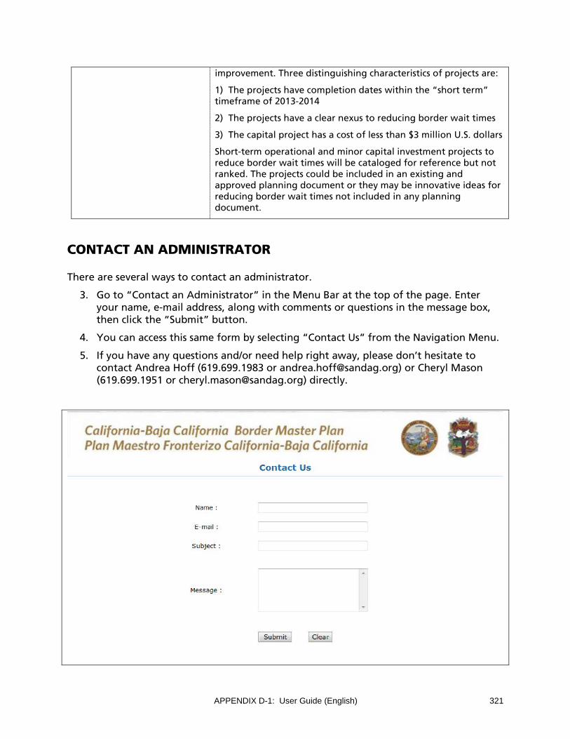
APPENDIX D-1: User Guide (English) 321
improvement. Three distinguishing characteristics of projects are:
1) The projects have completion dates within the “short term” timeframe of 2013-2014
2) The projects have a clear nexus to reducing border wait times
3) The capital project has a cost of less than $3 million U.S. dollars
Short-term operational and minor capital investment projects to reduce border wait times will be cataloged for reference but not ranked. The projects could be included in an existing and approved planning document or they may be innovative ideas for reducing border wait times not included in any planning document.
CONTACT AN ADMINISTRATOR
There are several ways to contact an administrator.
3. Go to “Contact an Administrator” in the Menu Bar at the top of the page. Enter your name, e-mail address, along with comments or questions in the message box, then click the “Submit” button.
4. You can access this same form by selecting “Contact Us” from the Navigation Menu.
5. If you have any questions and/or need help right away, please don’t hesitate to contact Andrea Hoff (619.699.1983 or [email protected]) or Cheryl Mason (619.699.1951 or [email protected]) directly.

322 APPENDIX D-1: User Guide (English)
HOW TO VIEW MY PROJECTS
1. Go to “View My Projects” in the Menu Bar at the top of the page.
2. Below “View My Projects”, click on the Project Type’s drop down list. Select the Project Type you would like to view.
3. Click on the “View” link next to the project you wish to view. Use the “Next” button to navigate through the project description boxes to review the information.
4. Click on the “Map” link to view the project location.
Note: You will not be allowed to make edits, only view data for existing projects.

APPENDIX D-1: User Guide (English) 323
HOW TO VIEW PROJECTS OF OTHERS
1. Go to “View Others Projects” in the Menu Bar at the top of the page.
2. Click on the Project Type drop down list. Select the Project Type you would like to view.
3. Click on the “View” link next to the project you wish to view. Use the “Next” button to navigate through the project description boxes to review the information. Projects submitted by your agency will not be listed here.
Note: You will not able to change the data for projects submitted by other agencies.

324 APPENDIX D-1: User Guide (English)
HOW TO EDIT PROJECTS:
Projects submitted by your agency during the 2008 were preloaded into the Web-based data base. In this view, you can update or delete projects already included in the list of projects.
Please review all projects in the “Edit My Projects” tab and delete any that have been completed or that are no longer proposed. If the project is still an existing project, you can use this “Edit My Projects” option to update the information for the project.
If the project has changed significantly from when it was submitted in the 2008 BMP, e.g. changed from one large project into project phases, then please delete the original project and enter the new project data for each phase using the “New Projects” tab.
1. Go to “Edit My Projects” in the Menu Bar at the top of the page.
2. Click on the Project Type drop down list. Select the Project Type.
3. Review list of projects and delete any that have been completed or that are no longer proposed.
4. Click on “Edit” or “Delete” on the left hand side of the project and revise accordingly.
Note: As you edit the project, you’ll notice that some data entry fields (Project ID and date fields) are automatically assigned by the system.

APPENDIX D-1: User Guide (English) 325
5. Once you have updated the project data, the following messages will appear:
Thank you for using the BMP Data Management Portal. Project has been successfully updated.
If you have not updated or added your project location, please go to “Edit My Projects” tab and click Map button to map project location.
Are you ready to submit? Please go to “Submit Projects” tab so that your project is ranked/listed.
6. To map the location of the project, click on “>>Back” button to return to “Edit My
Projects” tab.
7. Click on “Map” for the particular project to view a map of project location.
8. Follow instructions for updating project location in “How do I Map My Projects?” later in this User Guide. Instructions for mapping project locations are also included online.
Reminder: It is very important that after the project data have been entered and the project locations mapped, that all projects be submitted. Be sure to go to “Submit Projects” tab so that your project is ranked/listed. Projects must be submitted by the Submission Deadline in order to be ranked/listed.
Instruction Button
For a detailed instructions on data fields, click on the “Instructions” button. Note: instructions are also included at the end of this User Guide. See “Detailed Instructions for Entering Project Data.
Currency Conversion Button
A currency converter is provided to convert between 2010 Mexican Pesos and U.S. Dollars. Please report all project costs in U.S. dollars. It is not necessary to use this tool if project costs are already in U.S. dollars. This tool is more for projects with costs in Mexican Pesos.
1. Click on the Currency Converter button to access this tool.
2. Select the conversion type, enter the amount, then click “Convert.”

326 APPENDIX D-1: User Guide (English)
3. Please copy and paste the US dollar amount into the Project Cost field.

APPENDIX D-1: User Guide (English) 327
HOW TO ADD NEW PROJECTS:
All new projects are to be entered using the “Add New Projects” tab.
1. Go to “Add New Projects” in the Menu Bar at the top of the screen.
2. Click on the Project Type drop down list. Select the Project Type.
3. Complete data fields per the instructions. Use the “Next” button to navigate through the data screens. Please answer as much information as possible as the data are important for ranking projects.
4. Once you have completed data entry, click on the “Add to My List” button to add the project to your list.
Note: As you edit the project, you’ll notice that some data entry fields (Project ID and date fields) are automatically assigned by the system.
For a detailed explanation of data fields and currency conversion tools, see “Instructions” and “Currency Conversion” in the “How to Edit Projects” section of this User Guide. The

328 APPENDIX D-1: User Guide (English)
detailed explanation of data fields is also included at the end of this User Guide. See “Detailed Instructions for Entering Project Data.
5. After clicking the “Add to My List” button, the following messages will appear:
Thank you for using the BMP Data Management Portal. Project has been successfully added.
Please go to “Edit My Projects” tab and click Map button to add project location.
6. To map the location of the project, click on “>>Back” button.
7. Click on “Map” for the particular project to view a map of project location.
8. Follow instructions for updating project location in “How do I Map My Projects?” later in this User Guide. Instructions for mapping project locations are also included online.
Reminder: It is very important that after the project data have been entered and the project locations mapped, that all projects be submitted. Be sure to go to “Submit Projects” tab so that your project is ranked/listed. Projects must be submitted by the Submission Deadline in order to be ranked/listed.

APPENDIX D-1: User Guide (English) 329
HOW TO SUBMIT PROJECTS:
It is very important that after the project data have been entered and the project locations mapped, that all projects be submitted. Be sure to go to “Submit Projects” tab so that your project is ranked/listed.
Projects must be submitted by the Submission Deadline in order to be ranked/ listed.
1. Go to “Submit Projects” in the Menu Bar at the top of the page.
2. Click on the “Project Type” drop down list. Select the Project Type you would like to submit.
3. Click on the “Submit” button. Once submitted, your project will disappear from the list. You can still see your project in the “View My Projects” and in the “Edit My Projects” tabs.
Can I make changes to a project after I submitted it?
If, at any time during the open submission period, you submit your project, and then realize that a correction is needed, go to the “Edit My Project” tab and edit the project as needed. Your project will reappear on the “Submit Projects” tab and you can resubmit it.
The system will not permit projects to be edited or submitted after the submission date has been closed.
330 APPENDIX D-1: User Guide (English)
HOW DO I MAP MY PROJECTS?
After entering in the project data, you are asked to map the project location.
1. Go to “Edit My Project” tab.
2. Select “Map” to map project location.
3. Follow instructions for mapping project locations for Existing Projects or New Projects. Instructions are shown below as well.

APPENDIX D-1: User Guide (English) 331
Existing Project
1. Click on the project to activate.
2. A pop-up window will appear.
a. Is project displayed correctly?
b. If yes, select “Yes” in drop down menu and click “OK” to save.
c. If no, please click on “Delete,” then click on “ADD/AGREGAR” tab to redraw project. Follow instructions in the “ADD/AGREGAR” tab.
Note: To exit mapping, click “X” in upper right hand corner.
Add Project
1. Zoom into project location.
2. Select “line” tool or “point” tool.
3. If drawing a line,
a. Click to start drawing.
b. Click to continue drawing.
c. Double click to complete.
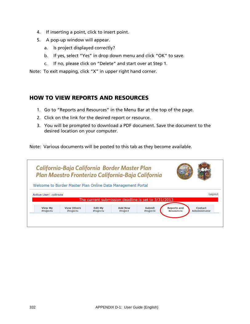
332 APPENDIX D-1: User Guide (English)
4. If inserting a point, click to insert point.
5. A pop-up window will appear.
a. Is project displayed correctly?
b. If yes, select “Yes” in drop down menu and click “OK” to save.
c. If no, please click on “Delete” and start over at Step 1.
Note: To exit mapping, click “X” in upper right hand corner.
HOW TO VIEW REPORTS AND RESOURCES
1. Go to “Reports and Resources” in the Menu Bar at the top of the page.
2. Click on the link for the desired report or resource.
3. You will be prompted to download a PDF document. Save the document to the desired location on your computer.
Note: Various documents will be posted to this tab as they become available.

APPENDIX D-1: User Guide (English) 333
DETAILED INSTRUCTION FOR ENTERING PROJECT DATA
The following detailed instructions are intended to help TWG representatives enter project information into the Online Data Management Portal. These instructions are also available by clicking on the “Instructions” button.
Port of Entry (POE) Projects
The following detailed instructions are intended to help TWG representatives enter project information into the Online Data Management Portal.
POE Projects Description of Data Fields
County or Jurisdiction Please provide the name of the county or municipality where the project is located.
Project Name and Location Please provide the project name and POE where projected is located.
Project Description Please provide a brief description of the project including additional number of lanes, lane types, or new facilities that will be provided by this project.
Existing Condition Please describe the existing condition including current number of lanes and lane types.
Condition after Project Completion (2040) Please describe the condition after project improvement.
Projected (2040) Total Numbe of Northbound Lanes into US
Please type in the projected number of northbound lanes that correspond to the project. For instance, if the project will expand the number of passenger vehicle lanes, please provide the total number of lanes for passenger vehicles, SENTRI, READY, and bus. If the project is an expansion of truck lanes, then provide the total number of lanes for regular trucks, FAST, and if available, number of “empty only” truck lanes. If it is a new POE, then provide projected number of lanes for all lane types. In order to rank the projects against the criteria, it is important that only one value for each type of lane be provided; therefore, please do not include ranges.
Projected (2040) Average Daily Vehicles/ Pedestrians/ Trucks Processed (Throughput)
Please type in the projected 2040 average daily throughput that corresponds to the project. For instance, if the project will expand the number of passenger vehicle lanes, please provide daily throughput for passenger vehicles, SENTRI, READY, and bus. If the project is an expansion of truck lanes, then provide the daily throughput for regular trucks and FAST. If it is a new POE, then provide projected average daily throughput for all lane types. In order to rank the projects against the criteria, it is important that only one value for each type of lane be provided; therefore, please do not include ranges.
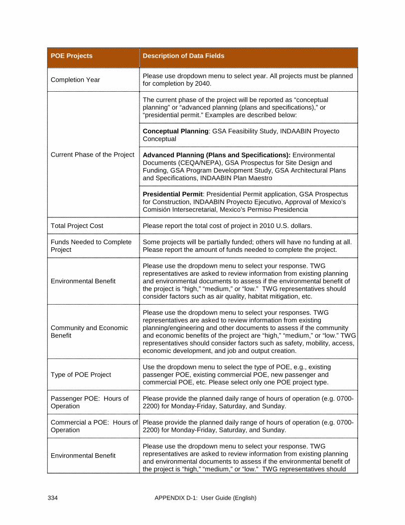
334 APPENDIX D-1: User Guide (English)
POE Projects Description of Data Fields
Completion Year Please use dropdown menu to select year. All projects must be planned for completion by 2040.
Current Phase of the Project
The current phase of the project will be reported as “conceptual planning” or “advanced planning (plans and specifications),” or “presidential permit.” Examples are described below:
Conceptual Planning: GSA Feasibility Study, INDAABIN Proyecto Conceptual
Advanced Planning (Plans and Specifications): Environmental Documents (CEQA/NEPA), GSA Prospectus for Site Design and Funding, GSA Program Development Study, GSA Architectural Plans and Specifications, INDAABIN Plan Maestro
Presidential Permit: Presidential Permit application, GSA Prospectus for Construction, INDAABIN Proyecto Ejecutivo, Approval of Mexico’s Comisión Intersecretarial, Mexico’s Permiso Presidencia
Total Project Cost Please report the total cost of project in 2010 U.S. dollars.
Funds Needed to Complete Project
Some projects will be partially funded; others will have no funding at all. Please report the amount of funds needed to complete the project.
Environmental Benefit
Please use the dropdown menu to select your response. TWG representatives are asked to review information from existing planning and environmental documents to assess if the environmental benefit of the project is “high,” “medium,” or “low.” TWG representatives should consider factors such as air quality, habitat mitigation, etc.
Community and Economic Benefit
Please use the dropdown menu to select your responses. TWG representatives are asked to review information from existing planning/engineering and other documents to assess if the community and economic benefits of the project are “high,” “medium,” or “low.” TWG representatives should consider factors such as safety, mobility, access, economic development, and job and output creation.
Type of POE Project Use the dropdown menu to select the type of POE, e.g., existing passenger POE, existing commercial POE, new passenger and commercial POE, etc. Please select only one POE project type.
Passenger POE: Hours of Operation
Please provide the planned daily range of hours of operation (e.g. 0700-2200) for Monday-Friday, Saturday, and Sunday.
Commercial a POE: Hours of Operation
Please provide the planned daily range of hours of operation (e.g. 0700-2200) for Monday-Friday, Saturday, and Sunday.
Environmental Benefit Please use the dropdown menu to select your response. TWG representatives are asked to review information from existing planning and environmental documents to assess if the environmental benefit of the project is “high,” “medium,” or “low.” TWG representatives should
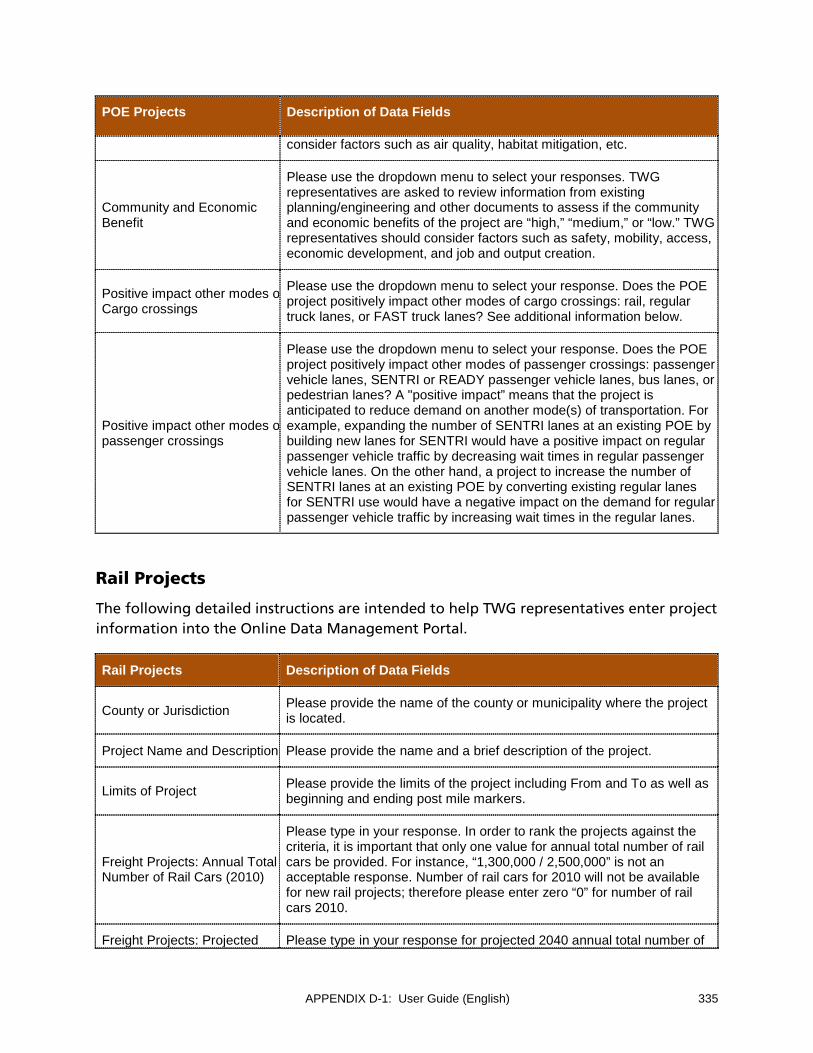
APPENDIX D-1: User Guide (English) 335
POE Projects Description of Data Fields
consider factors such as air quality, habitat mitigation, etc.
Community and Economic Benefit
Please use the dropdown menu to select your responses. TWG representatives are asked to review information from existing planning/engineering and other documents to assess if the community and economic benefits of the project are “high,” “medium,” or “low.” TWG representatives should consider factors such as safety, mobility, access, economic development, and job and output creation.
Positive impact other modes o Cargo crossings
Please use the dropdown menu to select your response. Does the POE project positively impact other modes of cargo crossings: rail, regular truck lanes, or FAST truck lanes? See additional information below.
Positive impact other modes o passenger crossings
Please use the dropdown menu to select your response. Does the POE project positively impact other modes of passenger crossings: passenger vehicle lanes, SENTRI or READY passenger vehicle lanes, bus lanes, or pedestrian lanes? A "positive impact” means that the project is anticipated to reduce demand on another mode(s) of transportation. For example, expanding the number of SENTRI lanes at an existing POE by building new lanes for SENTRI would have a positive impact on regular passenger vehicle traffic by decreasing wait times in regular passenger vehicle lanes. On the other hand, a project to increase the number of SENTRI lanes at an existing POE by converting existing regular lanes for SENTRI use would have a negative impact on the demand for regular passenger vehicle traffic by increasing wait times in the regular lanes.
Rail Projects
The following detailed instructions are intended to help TWG representatives enter project information into the Online Data Management Portal.
Rail Projects Description of Data Fields
County or Jurisdiction Please provide the name of the county or municipality where the project is located.
Project Name and Description Please provide the name and a brief description of the project.
Limits of Project Please provide the limits of the project including From and To as well as beginning and ending post mile markers.
Freight Projects: Annual Total Number of Rail Cars (2010)
Please type in your response. In order to rank the projects against the criteria, it is important that only one value for annual total number of rail cars be provided. For instance, “1,300,000 / 2,500,000” is not an acceptable response. Number of rail cars for 2010 will not be available for new rail projects; therefore please enter zero “0” for number of rail cars 2010.
Freight Projects: Projected Please type in your response for projected 2040 annual total number of
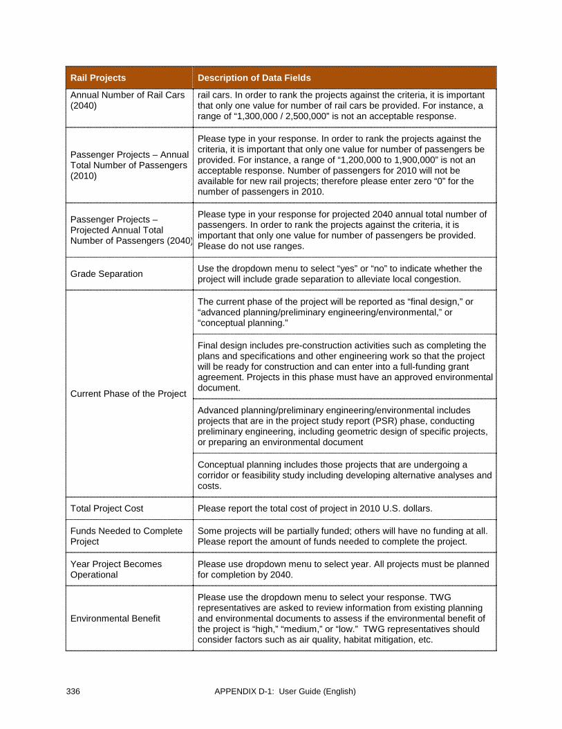
336 APPENDIX D-1: User Guide (English)
Rail Projects Description of Data Fields
Annual Number of Rail Cars (2040)
rail cars. In order to rank the projects against the criteria, it is important that only one value for number of rail cars be provided. For instance, a range of “1,300,000 / 2,500,000” is not an acceptable response.
Passenger Projects – Annual Total Number of Passengers (2010)
Please type in your response. In order to rank the projects against the criteria, it is important that only one value for number of passengers be provided. For instance, a range of “1,200,000 to 1,900,000” is not an acceptable response. Number of passengers for 2010 will not be available for new rail projects; therefore please enter zero “0” for the number of passengers in 2010.
Passenger Projects – Projected Annual Total Number of Passengers (2040)
Please type in your response for projected 2040 annual total number of passengers. In order to rank the projects against the criteria, it is important that only one value for number of passengers be provided. Please do not use ranges.
Grade Separation Use the dropdown menu to select “yes” or “no” to indicate whether the project will include grade separation to alleviate local congestion.
Current Phase of the Project
The current phase of the project will be reported as “final design,” or “advanced planning/preliminary engineering/environmental,” or “conceptual planning.”
Final design includes pre-construction activities such as completing the plans and specifications and other engineering work so that the project will be ready for construction and can enter into a full-funding grant agreement. Projects in this phase must have an approved environmental document.
Advanced planning/preliminary engineering/environmental includes projects that are in the project study report (PSR) phase, conducting preliminary engineering, including geometric design of specific projects, or preparing an environmental document
Conceptual planning includes those projects that are undergoing a corridor or feasibility study including developing alternative analyses and costs.
Total Project Cost Please report the total cost of project in 2010 U.S. dollars.
Funds Needed to Complete Project
Some projects will be partially funded; others will have no funding at all. Please report the amount of funds needed to complete the project.
Year Project Becomes Operational
Please use dropdown menu to select year. All projects must be planned for completion by 2040.
Environmental Benefit
Please use the dropdown menu to select your response. TWG representatives are asked to review information from existing planning and environmental documents to assess if the environmental benefit of the project is “high,” “medium,” or “low.” TWG representatives should consider factors such as air quality, habitat mitigation, etc.

APPENDIX D-1: User Guide (English) 337
Rail Projects Description of Data Fields
Community and Economic Benefit
Please use the dropdown menu to select your responses. TWG representatives are asked to review information from existing planning/engineering and other documents to assess if the community and economic benefits of the project are “high,” “medium,” or “low.” TWG representatives should consider factors such as safety, mobility, access, economic development, and job and output creation.
POE Primarily Served by the Project
Use the dropdown menu to select the POE that the project primarily serves. Please select only one POE. You may type in the name of a new POE if it is not listed in the dropdown menu.
Has Terminus or Connects to Rail Line that has a Terminus at International Border
Use the dropdown menu to select your response. Select “Has a terminus at international border” if the project is on a segment of rail line that crosses or has a terminus at the international border. Select “Connects to a rail line with a terminus at the international border” if the project does not terminate at the international border but does connect to a terminus facility. Select “Neither” if neither situation applies.
How Serves a POE Please explain how the project serves an International POE.
Interchange Projects
The following detailed instructions are intended to help TWG representatives enter project information into the Online Data Management Portal.
Interchange Projects Description of Data Fields
County or Jurisdiction Please provide the name of the county or municipality where the project is located.
Project Name and Description
Please provide the name and a brief description of the project.
Ramp Please provide the direction of the ramp.
Existing Condition by Ramp (2010)
Please describe the current number of lanes by ramp.
Condition After Project Completion (2040)
Please describe the projected number of lanes by ramp.
Name of Nearest interchange
For new interchanges, please report 2010 data for the nearest interchange. Please list the name of the nearest interchange and use data for this facility where necessary.
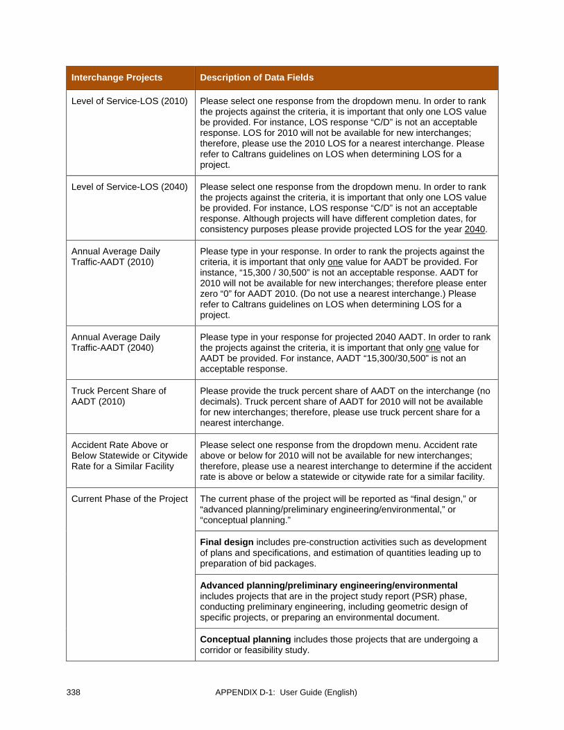
338 APPENDIX D-1: User Guide (English)
Interchange Projects Description of Data Fields
Level of Service-LOS (2010) Please select one response from the dropdown menu. In order to rank the projects against the criteria, it is important that only one LOS value be provided. For instance, LOS response “C/D” is not an acceptable response. LOS for 2010 will not be available for new interchanges; therefore, please use the 2010 LOS for a nearest interchange. Please refer to Caltrans guidelines on LOS when determining LOS for a project.
Level of Service-LOS (2040) Please select one response from the dropdown menu. In order to rank the projects against the criteria, it is important that only one LOS value be provided. For instance, LOS response “C/D” is not an acceptable response. Although projects will have different completion dates, for consistency purposes please provide projected LOS for the year 2040.
Annual Average Daily Traffic-AADT (2010)
Please type in your response. In order to rank the projects against the criteria, it is important that only one value for AADT be provided. For instance, “15,300 / 30,500” is not an acceptable response. AADT for 2010 will not be available for new interchanges; therefore please enter zero “0” for AADT 2010. (Do not use a nearest interchange.) Please refer to Caltrans guidelines on LOS when determining LOS for a project.
Annual Average Daily Traffic-AADT (2040)
Please type in your response for projected 2040 AADT. In order to rank the projects against the criteria, it is important that only one value for AADT be provided. For instance, AADT “15,300/30,500” is not an acceptable response.
Truck Percent Share of AADT (2010)
Please provide the truck percent share of AADT on the interchange (no decimals). Truck percent share of AADT for 2010 will not be available for new interchanges; therefore, please use truck percent share for a nearest interchange.
Accident Rate Above or Below Statewide or Citywide Rate for a Similar Facility
Please select one response from the dropdown menu. Accident rate above or below for 2010 will not be available for new interchanges; therefore, please use a nearest interchange to determine if the accident rate is above or below a statewide or citywide rate for a similar facility.
Current Phase of the Project The current phase of the project will be reported as “final design,” or “advanced planning/preliminary engineering/environmental,” or “conceptual planning.”
Final design includes pre-construction activities such as development of plans and specifications, and estimation of quantities leading up to preparation of bid packages.
Advanced planning/preliminary engineering/environmental includes projects that are in the project study report (PSR) phase, conducting preliminary engineering, including geometric design of specific projects, or preparing an environmental document.
Conceptual planning includes those projects that are undergoing a corridor or feasibility study.

APPENDIX D-1: User Guide (English) 339
Interchange Projects Description of Data Fields
Total Project Cost Please report the total cost of project in 2010 U.S. dollars.
Funds Needed to Complete Project
Some projects will be partially funded; others will have no funding at all. Please report the amount of funds needed to complete the project.
Year Project Becomes Operational
All projects must be planned for completion between 2013 and 2040.
Mulitmodal Benefits Use the dropdown menu to select “yes” or “no” for each travel mode the project will accommodate: bicycle lanes/paths, high occupancy vehicle (HOV)/transit lanes, and/or pedestrian walkways.
Environmental Benefit Please use the dropdown menu to select your response. TWG representatives are asked to review information from existing planning and environmental documents to assess if the environmental benefit of the project is “high,” “medium,” or “low.” TWG representatives should consider factors such as air quality, habitat mitigation, etc.
Community and Economic Benefit
Please use the dropdown menu to select your responses. TWG representatives are asked to review information from existing planning/engineering and other documents to assess if the community and economic benefits of the project are “high,” “medium,” or “low.” TWG representatives should consider factors such as safety, mobility, access, economic development, and job and output creation.
POE Primarily Served by the Project
Use the dropdown menu to select the POE that the project primarily serves. Please select only one POE. You may type in the name of a new POE if it is not listed in the dropdown menu.
Terminus Facility or Connected to a Terminus Facility
Use the dropdown menu to select your response. Select “On a terminus facility” if the project is on a segment that has a terminus at a POE (called a “terminus facility.”) Select “Connects to a terminus facility” if the project does not terminate at a POE but does connect to a terminus facility. Select “Neither” if neither situation applies.
How Serves a POE Please explain how the project serves a POE.
Roadway Projects
The following detailed instructions are intended to help TWG representatives enter project information into the Online Data Management Portal.
Roadway Projects Description of Data Fields
County or Jurisdiction Please provide the name of the county or municipality where the project is located.
Project Name and Description
Please provide the name and a brief description of the project.
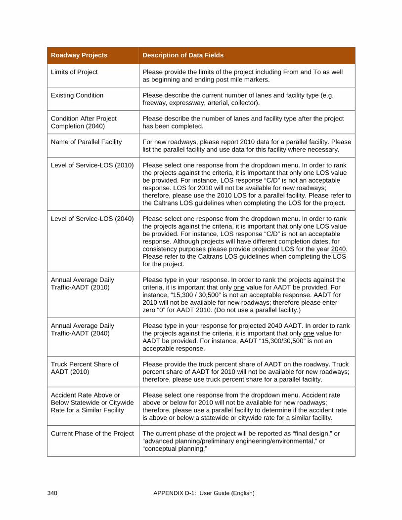
340 APPENDIX D-1: User Guide (English)
Roadway Projects Description of Data Fields
Limits of Project Please provide the limits of the project including From and To as well as beginning and ending post mile markers.
Existing Condition Please describe the current number of lanes and facility type (e.g. freeway, expressway, arterial, collector).
Condition After Project Completion (2040)
Please describe the number of lanes and facility type after the project has been completed.
Name of Parallel Facility For new roadways, please report 2010 data for a parallel facility. Please list the parallel facility and use data for this facility where necessary.
Level of Service-LOS (2010) Please select one response from the dropdown menu. In order to rank the projects against the criteria, it is important that only one LOS value be provided. For instance, LOS response “C/D” is not an acceptable response. LOS for 2010 will not be available for new roadways; therefore, please use the 2010 LOS for a parallel facility. Please refer to the Caltrans LOS guidelines when completing the LOS for the project.
Level of Service-LOS (2040) Please select one response from the dropdown menu. In order to rank the projects against the criteria, it is important that only one LOS value be provided. For instance, LOS response “C/D” is not an acceptable response. Although projects will have different completion dates, for consistency purposes please provide projected LOS for the year 2040. Please refer to the Caltrans LOS guidelines when completing the LOS for the project.
Annual Average Daily Traffic-AADT (2010)
Please type in your response. In order to rank the projects against the criteria, it is important that only one value for AADT be provided. For instance, “15,300 / 30,500” is not an acceptable response. AADT for 2010 will not be available for new roadways; therefore please enter zero “0” for AADT 2010. (Do not use a parallel facility.)
Annual Average Daily Traffic-AADT (2040)
Please type in your response for projected 2040 AADT. In order to rank the projects against the criteria, it is important that only one value for AADT be provided. For instance, AADT “15,300/30,500” is not an acceptable response.
Truck Percent Share of AADT (2010)
Please provide the truck percent share of AADT on the roadway. Truck percent share of AADT for 2010 will not be available for new roadways; therefore, please use truck percent share for a parallel facility.
Accident Rate Above or Below Statewide or Citywide Rate for a Similar Facility
Please select one response from the dropdown menu. Accident rate above or below for 2010 will not be available for new roadways; therefore, please use a parallel facility to determine if the accident rate is above or below a statewide or citywide rate for a similar facility.
Current Phase of the Project The current phase of the project will be reported as “final design,” or “advanced planning/preliminary engineering/environmental,” or “conceptual planning.”

APPENDIX D-1: User Guide (English) 341
Roadway Projects Description of Data Fields
Final design includes pre-construction activities such as development of plans and specifications, and estimation of quantities leading up to preparation of bid packages.
Advanced planning/preliminary engineering/environmental includes projects that are in the project study report (PSR) phase, conducting preliminary engineering, including geometric design of specific projects, or preparing an environmental document.
Conceptual planning includes those projects that are undergoing a corridor or feasibility study.
Total Project Cost (2010$USD)
Please report the total cost of project in 2010 U.S. dollars.
Funds Needed to Complete Project
Some projects will be partially funded; others will have no funding at all. Please report the amount of funds needed to complete the project.
Year Project Becomes Operational
All projects must be planned for completion between 2013 and 2040.
Mulitmodal Benefits Use the dropdown menu to select “yes” or “no” for each travel mode the project will accommodate: bicycle lanes/paths, high occupancy vehicle (HOV)/transit lanes, and/or pedestrian walkways. It is anticipated that most arterial roadway projects would accommodate pedestrians and bicycle traffic in 2040.
Environmental Benefit Please use the dropdown menu to select your response. TWG representatives are asked to review information from existing planning and environmental documents to assess if the environmental benefit of the project is “high,” “medium,” or “low.” TWG representatives should consider factors such as air quality, habitat mitigation, etc.
Community and Economic Benefit
Please use the dropdown menu to select your responses. TWG representatives are asked to review information from existing planning/engineering and other documents to assess if the community and economic benefits of the project are “high,” “medium,” or “low.” TWG representatives should consider factors such as safety, mobility, access, economic development, and job and output creation.
POE Primarily Served by the Project
Use the dropdown menu to select the POE that the project primarily serves. Please select only one POE. You may type in the name of a new POE if it is not listed in the dropdown menu.
Terminus Facility or Connected to a Terminus Facility
Use the dropdown menu to select your response. Select “On a terminus facility” if the project is on a segment that has a terminus at a POE (called a “terminus facility.”) Select “Connects to a terminus facility” if the project does not terminate at a POE but does connect to a terminus facility. Select “Neither” if neither situation applies.
How Serves a POE Please explain how the project serves a POE.

342 APPENDIX D-1: User Guide (English)
Non-motorized Modes of Cross Border Travel
Non-motorized projects are walking and bicycling capital infrastructure projects.
Projects for the non-motorized modes of cross border travel category would be cataloged for reference but not ranked. The projects submitted should be included in an existing and approved planning document of one or more BMP participating agency.
The following detailed instructions are intended to help TWG representatives enter project information into the Online Data Management Portal.
Non-motorized Modes Description of Data Fields
County or Jurisdiction Please provide the name of the county or municipality where the project is located.
Project Name and Description
Please provide the name and a brief description of the project.
Project Type Please select either "bicycle" or "pedestrian"
Project Location Please provide the location of the project (POE or city)
Limits of Project Please provide the limits of the project including From and To as well as beginning and ending post mile markers if appropriate.
Existing Condition Please describe the existing condition.
Condition After Project Completion (2040)
Please describe the condition after project improvement.
Current Phase of the Project The current phase of the project will be reported as “final design,” or “advanced planning/preliminary engineering/environmental,” or “conceptual planning.”
Final design includes pre-construction activities such as development of plans and specifications, and estimation of quantities leading up to preparation of bid packages.
Advanced planning/preliminary engineering/environmental includes projects that are in the project study report (PSR) phase, conducting preliminary engineering, including geometric design of specific projects, or preparing an environmental document.
Conceptual planning includes those projects that are undergoing a corridor or feasibility study.
Total Project Cost (2010$USD)
Please report the total cost of project in 2010 U.S. dollars.
Funds Needed to Complete Project
Some projects will be partially funded; others will have no funding at all. Please report the amount of funds needed to complete the project.

APPENDIX D-1: User Guide (English) 343
Non-motorized Modes Description of Data Fields
Year Project Becomes Operational
All projects must be planned for completion between 2013 and 2040.
POE Primarily Served by the Project
Select the POE that the project primarily serves. Please select only one POE. You may type in the name of a new POE if it is not listed in the dropdown menu.
Terminus Facility or Connected to a Terminus Facility
Select “On a terminus facility” if the project is on a segment that has a terminus at a POE (called a “terminus facility.”) Select “Connects to a terminus facility” if the project does not terminate at a POE but does connect to a terminus facility. Select “Neither” if neither situation applies.
How Serves a POE Please explain how the project serves a POE.
Short-term Operational and Minor Capital Investment Projects to Reduce Border Wait Times
Short-term operational and minor capital investment projects are projects that intend to facilitate federal processing of pedestrians and vehicles at the POEs and thus expedite the flow of people and cargo. Minor capital investment projects are infrastructure improvements that have a relatively low monetary cost and may be stand-alone projects or associated with an operational improvement.
Three distinguishing characteristics of these projects are:
1) The projects have completion dates within the “short term” timeframe of 2013-2014 2) The projects have a clear nexus to reducing border wait times 3) The capital project has a cost of less than $3 million U.S. dollars Short-term operational and minor capital investment projects to reduce border wait times would be cataloged for reference but not ranked. The projects could be included in an existing and approved planning document or they may be innovative ideas for reducing border wait times not included in any planning document.
The following detailed instructions are intended to help TWG representatives enter project information into the Online Data Management Portal.
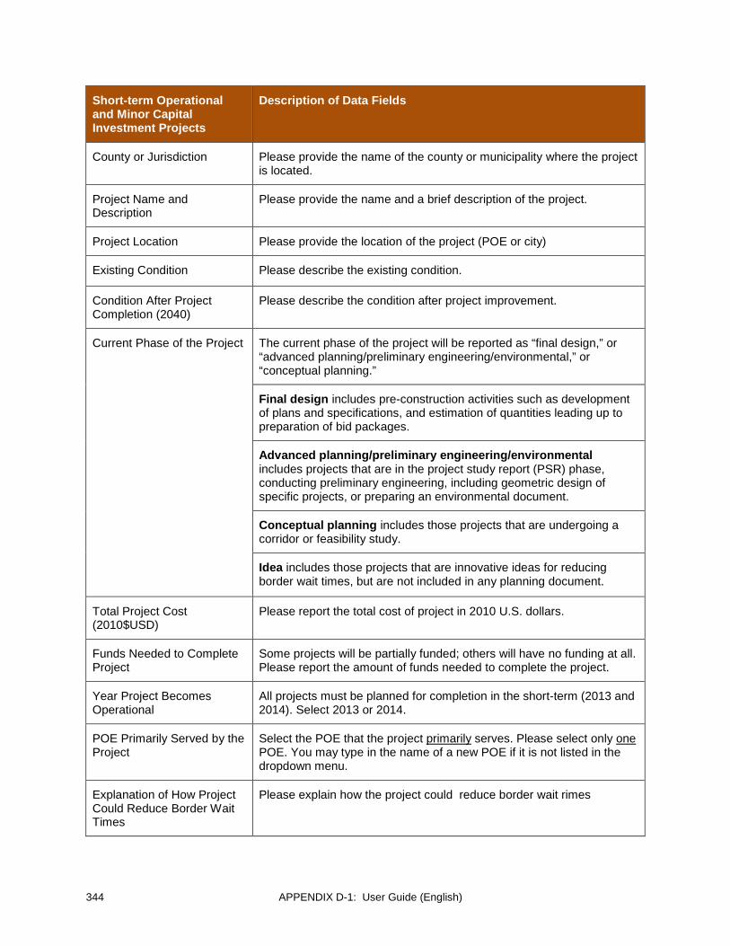
344 APPENDIX D-1: User Guide (English)
Short-term Operational and Minor Capital Investment Projects
Description of Data Fields
County or Jurisdiction Please provide the name of the county or municipality where the project is located.
Project Name and Description
Please provide the name and a brief description of the project.
Project Location Please provide the location of the project (POE or city)
Existing Condition Please describe the existing condition.
Condition After Project Completion (2040)
Please describe the condition after project improvement.
Current Phase of the Project The current phase of the project will be reported as “final design,” or “advanced planning/preliminary engineering/environmental,” or “conceptual planning.”
Final design includes pre-construction activities such as development of plans and specifications, and estimation of quantities leading up to preparation of bid packages.
Advanced planning/preliminary engineering/environmental includes projects that are in the project study report (PSR) phase, conducting preliminary engineering, including geometric design of specific projects, or preparing an environmental document.
Conceptual planning includes those projects that are undergoing a corridor or feasibility study.
Idea includes those projects that are innovative ideas for reducing border wait times, but are not included in any planning document.
Total Project Cost (2010$USD)
Please report the total cost of project in 2010 U.S. dollars.
Funds Needed to Complete Project
Some projects will be partially funded; others will have no funding at all. Please report the amount of funds needed to complete the project.
Year Project Becomes Operational
All projects must be planned for completion in the short-term (2013 and 2014). Select 2013 or 2014.
POE Primarily Served by the Project
Select the POE that the project primarily serves. Please select only one POE. You may type in the name of a new POE if it is not listed in the dropdown menu.
Explanation of How Project Could Reduce Border Wait Times
Please explain how the project could reduce border wait rimes
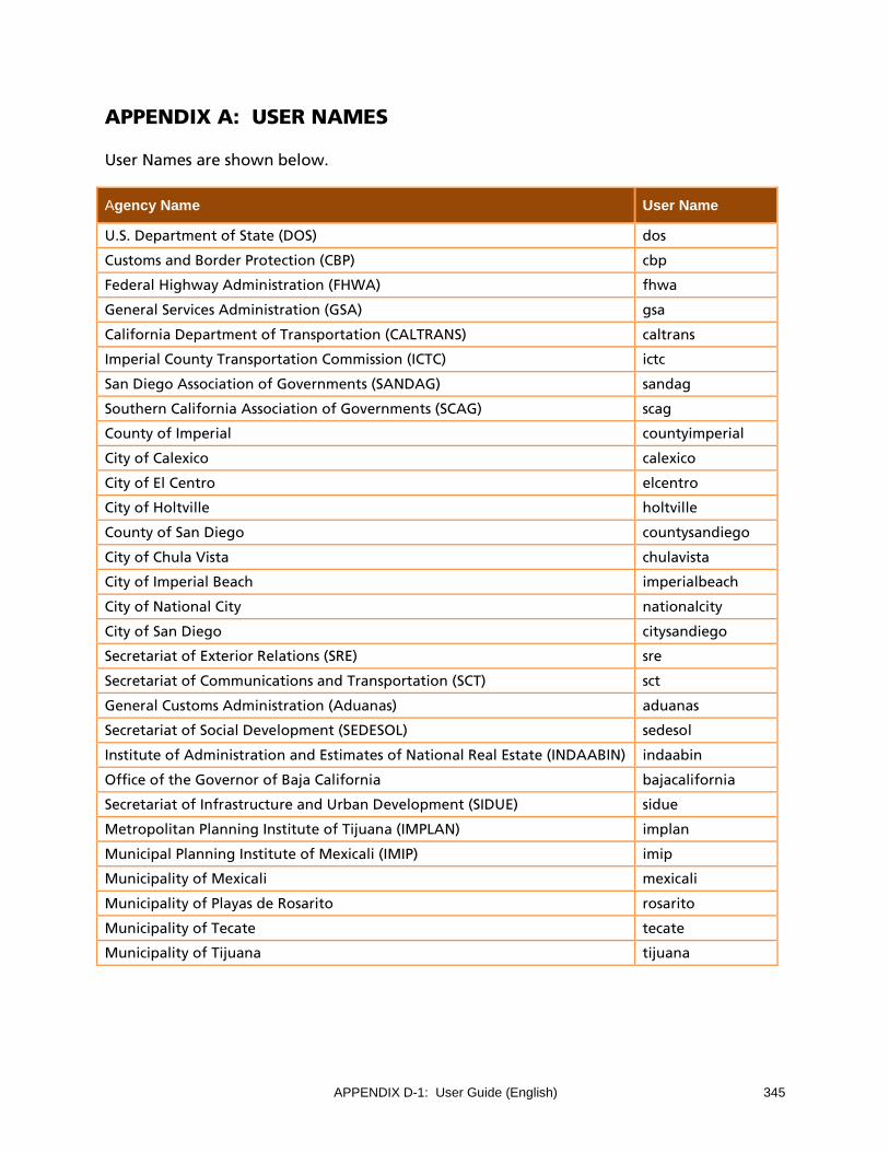
APPENDIX D-1: User Guide (English) 345
APPENDIX A: USER NAMES
User Names are shown below.
Agency Name User Name
U.S. Department of State (DOS) dos
Customs and Border Protection (CBP) cbp
Federal Highway Administration (FHWA) fhwa
General Services Administration (GSA) gsa
California Department of Transportation (CALTRANS) caltrans
Imperial County Transportation Commission (ICTC) ictc
San Diego Association of Governments (SANDAG) sandag
Southern California Association of Governments (SCAG) scag
County of Imperial countyimperial
City of Calexico calexico
City of El Centro elcentro
City of Holtville holtville
County of San Diego countysandiego
City of Chula Vista chulavista
City of Imperial Beach imperialbeach
City of National City nationalcity
City of San Diego citysandiego
Secretariat of Exterior Relations (SRE) sre
Secretariat of Communications and Transportation (SCT) sct
General Customs Administration (Aduanas) aduanas
Secretariat of Social Development (SEDESOL) sedesol
Institute of Administration and Estimates of National Real Estate (INDAABIN) indaabin
Office of the Governor of Baja California bajacalifornia
Secretariat of Infrastructure and Urban Development (SIDUE) sidue
Metropolitan Planning Institute of Tijuana (IMPLAN) implan
Municipal Planning Institute of Mexicali (IMIP) imip
Municipality of Mexicali mexicali
Municipality of Playas de Rosarito rosarito
Municipality of Tecate tecate
Municipality of Tijuana tijuana

This page intentionally left blank

APPENDIX D-2: User Guide (Spanish) 347
GUÍA DEL USUARIO PARA EL PORTAL DE GESTIÓN DE DATOS
Actualización del Plan Maestro Fronterizo California-Baja California (2014)
Febrero del 2013

348 APPENDIX D-2: User Guide (Spanish)

APPENDIX D-2: User Guide (Spanish) 349
TABLE OF CONTENTS
INTRODUCCIÓN ........................................................................................................................................... 351
Antecedentes .......................................................................................................................................... 351
ACCESO AL SITIO Y RESEÑA ....................................................................................................................... 353
¿Cómo accedo al Portal? ........................................................................................................................ 353
¿Qué es el Menú de Navegación? ......................................................................................................... 353
¿Cómo inicio sesión? ............................................................................................................................... 354
¿Cuál es mi Nombre de Usuario? ........................................................................................................... 355
¿Cuál es mi contraseña? ......................................................................................................................... 355
¿Qué hago si olvidé mi contraseña? ...................................................................................................... 355
¿Cómo cierro la sesión? .......................................................................................................................... 356
¿Qué es la Barra de Menú? .................................................................................................................... 356
¿Cuál es la fecha límite de presentación? ............................................................................................. 357
¿Qué es un Tipo de Proyecto?................................................................................................................ 357
CONTACTAR A UN ADMINISTRADOR ........................................................................................................ 359
CÓMO VER MIS PROYECTOS ...................................................................................................................... 360
CÓMO VER PROYECTOS DE OTRAS DEPENDENCIAS ................................................................................ 361
CÓMO EDITAR PROYECTOS: ...................................................................................................................... 362
Botón de Instrucciones ........................................................................................................................... 363
Botón para Conversión de Moneda ...................................................................................................... 364
CÓMO AGREGAR NUEVOS PROYECTOS: ................................................................................................... 365
CÓMO SOMETER UN PROYECTO: .............................................................................................................. 367
¿Es posible hacer cambios a un proyecto una vez que lo presente? .................................................. 367
¿CÓMO CAPTURO LA UBICACIÓN DE MI PROYECTO? ............................................................................. 368
Proyecto Actual ....................................................................................................................................... 369
Agregar un Nuevo Proyecto................................................................................................................... 369
CÓMO VER INFORMES Y RECURSOS .......................................................................................................... 371
INSTRUCCIONES DETALLADAS PARA LA CAPTURA DE DATOS DEL PROYECTO .................................... 372
Proyectos de Garitas ............................................................................................................................... 372
Proyectos Ferroviarios ............................................................................................................................. 375
Proyectos de Intercambios (Intersecciones) .......................................................................................... 377
Proyectos de Caminos ............................................................................................................................. 380
Proyectos de infraestructura para viajes transfronterizos no-motorizados ....................................... 383
Inversiones menores de capital y operativas a corto plazo para reducir los tiempos de espera en los cruces fronterizos .................................................................................................................................... 385
APÉNDICE A: NOMBRES DE USUARIO ....................................................................................................... 388
APPENDIX D-2: User Guide (Spanish) 351
Guía del Usuario para el Portal de Gestión de Datos del Plan Maestro Fronterizo California-Baja California
INTRODUCCIÓN
La presente Guía del Usuario incluye información respecto de cómo navegar dentro del portal de gestión de datos, así como instrucciones detalladas para ingresar datos de proyectos.
En caso de cualquier duda, por favor comunicarse directamente con Andrea Hoff (619.699.1983 ó [email protected]) o Cheryl Mason (619.699.1951 ó [email protected]) o seleccione la opción de “Contactar al Administrador” en la barra de menú para enviar un correo. Gracias de antemano por actualizar los proyectos correspondientes a su dependencia en el Portal de Gestión de Datos del Plan Maestro Fronterizo.
Antecedentes
La Tarea 7 de la Actualización del Plan Maestro Fronterizo California-Baja California (BMP, por su siglas en inglés) solicita que se actualicen los datos de proyectos de garitas terrestres y proyectos de transporte relacionados con los mismos y ajustar la priorización de proyectos a mediano y largo plazo según los criterios de evaluación y la metodología utilizados en el esfuerzo del BMP 2008 y las modificaciones que aprobó el Comité Asesor en Políticas (PAC, por sus siglas en inglés) el 15 de noviembre de 2012. Los proyectos de garitas terrestres se clasificarán en dos categorías principales: (1) garitas nuevas y (2) modernización de garitas existentes. Proyectos a corto plazo deberán catalogarse pero no jerarquizarse.
Durante su reunión celebrada el 15 de noviembre de 2012, el PAC aprobó la siguiente metodología:
1. La definición de plazos para fines de la Actualización del BMP será la siguiente.
Corto plazo: 2013-2014 Mediano plazo: 2015-2020 Largo plazo: 2021-2040
2. Se incorporarán criterios de monitoreo en función de Fase de Construcción y Estado del Financiamiento cuya finalidad será determinar cuáles proyectos deben calificarse para fines de priorización. Dicho proceso se detalla a continuación.
Los plazos para clasificar como corto, mediano y largo plazo se refieren a la fecha “de apertura al tránsito.”
352 APPENDIX D-2: User Guide (Spanish)
No se priorizarán proyectos a corto plazo; se catalogarán para fines informativos.
Aquellos proyectos que se encuentren en obra durante el periodo de corto plazo (2013-2014) no se priorizarán, incluso si su fecha de apertura al tránsito es posterior al 31 de diciembre de 2014.
Aquellos proyectos que cuenten con financiamiento completo no se priorizarán no obstante su plazo.
A solicitud del PAC, la Oficina de Servicios de SANDAG creará un segundo listado en el que se priorizarán proyectos que cuenten con financiamiento completo. La finalidad de esto es tener la capacidad de demostrar el lugar que ocupa el proyecto en la priorización en caso que un proyecto pierda financiamiento y por ende sean necesarios nuevos esfuerzos para procurar fondos a futuro. Dicho listado deberá incluirse en el apéndice del informe final y se le denominará el Listado Ampliado de Proyectos Priorizados para el BMP 2013-2014.
El proceso para someter proyectos de garitas y proyectos relacionados de transporte será el siguiente:
• Proyectos de garitas y proyectos relacionados de transporte a someterse por parte de dependencias participantes en el BMP deberán limitarse a aquellos dentro de la franja del “Área Enfocada de Estudio”, misma que se define como la zona de 10 millas (16 km.) al norte y 10 millas (16 km.) al sur de la frontera internacional entre Baja california y California. Los proyectos deberán incluirse dentro de un documento de planeación existente y aprobado.
• Proyectos de garitas deberán clasificarse dentro de una de dos categorías principales: (1) garitas nuevas y (2) modernización de garitas existentes. Los proyectos de garitas se priorizarán de manera independiente en cada una de estas dos categorías. Las dependencias participantes en el BMP se harán responsables de determinar si un proyecto se trata de una garita nueva o modernización de una garita existente.
• Los proyectos se agruparán de acuerdo a su cronograma como corto, mediano y largo plazo. Los proyectos a corto plazo deberán catalogarse mas no priorizarse. Proyectos a mediano y largo plazo para garitas, vialidades, ferrocarriles e intersecciones deberán priorizarse.
• Los representantes del Grupo Técnico de Trabajo registrarán los proyectos en un sistema en línea para la captura de datos creado exclusivamente para la Actualización del BMP. La fecha límite establecida aparece en el Portal de Gestión de Datos del BMP California-Baja California. El sistema no permite la presentación de proyectos de manera posterior a la fecha límite.
• Una vez que venza la fecha límite, la Oficina de Servicios de SANDAG descargará todos los proyectos y los priorizará según los criterios de evaluación que se establecieron en el esfuerzo del BMP 2008 y los criterios adicionales revisados y aprobados por el PAC.